Embed Size (px)
Citation preview
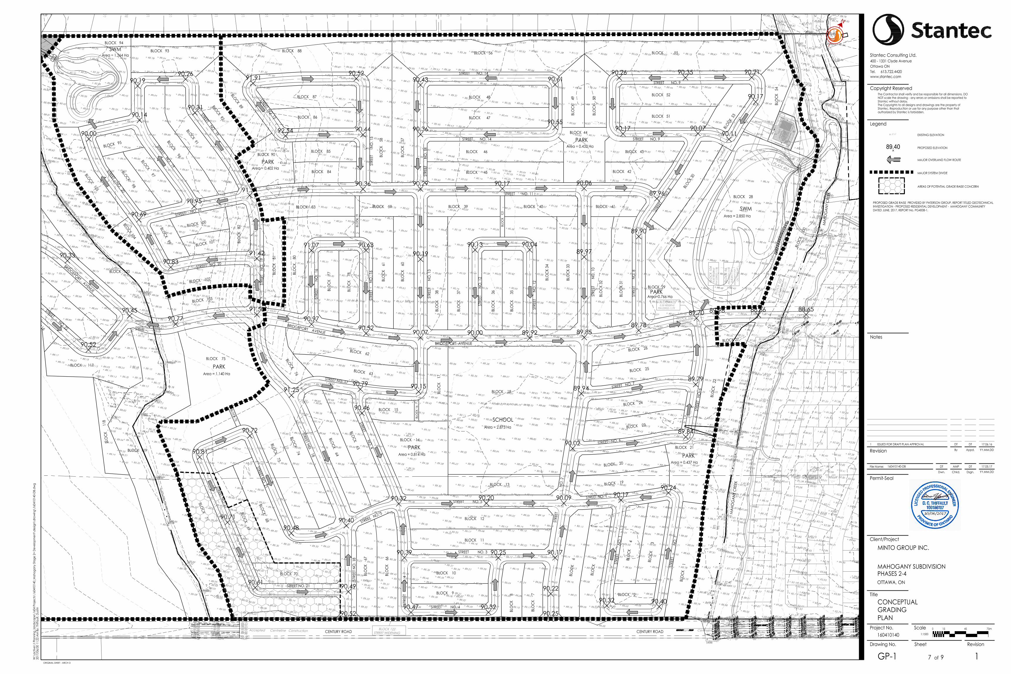
LOT 2
0
LOT 1
9
BLO
CK
40
LOT 1
8
LOT 1
7
LOT 1
6
LOT 1
5
LOT 1
4
LOT 1
3
LOT 1
2
LOT 1
1
LOT 1
0
LOT 9
LOT 8
LOT 7
LOT 6
LOT 5
LOT 4
LOT 3
LOT 2
LOT 1
LOT 2
7
LOT 2
6
Approximate Centreline of Drainage Ditch
Approximate C
entreline of Tributary
BLO
CK
100
SCHOOL
PARK
PARK
PARK
SWM
PARK
PARK
PARK
SWM
BLO
CK
1
STRE
ET
NO
. 1
STRE
ET
NO. 1
STREET NO. 1
BLOCK 2
BLO
CK
3
BLO
CK
4
BLO
CK
5
BLO
CK
6
STRE
ET
N
O. 2
BLO
CK
7
BLO
CK
8BLOCK 9
BLOCK 10
BLOCK 12
BLOCK 11
BLOCK 14
BLOCK 15
BLOCK 18BLO
CK
17
BLO
CK
16
BLOCK 13 BLOCK 19
BLOCK 20
BLOCK 21
BLO
CK
22
BLOCK 23
BLOCK 24
BLOCK 25
BLOCK 26
STREET NO. 3
STREET NO. 4
STRE
ET
NO. 4
STREET NO. 5
STREET NO. 4
STREET NO. 7
STREET NO. 6
STRE
ET
NO. 6
BRIDGEPORT AVENUE BLOCK 27
BLOCK 29
BLO
CK
31
BLO
CK
32BLO
CK
33
BLO
CK
34
BLO
CK
3
5
BLO
CK
3
6
BLO
CK
3
7
BLO
CK
3
8
BLOCK 39 BLOCK 40 BLOCK 41
BLOCK 28
BLOCK 3
0
BLO
CK
54
BLOCK 42
BLOCK 43
BLOCK 44
BLOCK 45
BLOCK 46
BLOCK 47
BLOCK 48
BLO
CK
49
BLO
CK
50
BLOCK 51
BLOCK 52
BLOCK
53
BLOCK 55BLOCK 56
STRE
ET
N
O. 8
STRE
ET
N
O. 1
0
STREET NO. 9
STREET NO. 9
STREE
T
NO. 8
STREET NO. 11
STRE
ET
N
O. 1
2
STRE
ET
N
O. 1
2
STRE
ET
N
O. 1
3ST
REET
NO
. 14
STREET NO. 14
STREET NO. 14
BLO
CK
57
BLO
CK
58
BLOCK 59
BLO
CK
60
BLO
CK
61
BLOCK 62
BLOCK 63
BLOCK 65
BLOCK 64
BLO
CK
66
BLO
CK
67
BLOCK 70
BLOCK 71
BLOCK 69
BLOCK 68
BLOCK 72
BLOCK 74
BLOCK 73
BLOCK 75 BLOCK 76
BLO
CK
79
BLO
CK
77
BLO
CK
78BL
OC
K
81
BLO
CK
80
BLO
CK
82
BLOCK 83
BLOCK 90BLOCK 85
BLOCK 84
BLOCK 87
BLOCK 86
BLOCK 88
BLOCK 89
BLOCK 92
BLOCK 91
BLOCK 93
BLOCK 94
STREET NO. 11
STRE
ET
N
O. 1
5
STREETNO. 15
STRE
ET
N
O.
16
STRE
ET
N
O.
16
BRIDGEPORT AVENUE
BRIDGEPORT AVENUE
STREET NO. 17
STREET NO. 18
STRE
ET N
O. 1
8
STRE
ET
NO
. 19
STREET NO. 19
STREET NO. 19STREET NO. 20
STREET NO. 20
STREET NO. 21
STREET NO. 21
STREET NO. 21
STREET NO. 5
STREET NO. 22
BLOCK 95 BLOCK 96BLOCK 97
BLOCK 98
BLOCK 99
BLOCK 100
BLOCK 101
BLOCK 102
BLOCK 103
BLOCK 104
BLOCK 105
BLOCK 116
BLOCK 117
BLO
CK
1
18
Area = 0.814 Ha
Area = 2.873 Ha
Area = 0.437 Ha
Area = 2.850 Ha
Area = 0.432 Ha
Area = 0.402 Ha
Area = 1.140 Ha
Area = 1.264 Ha
Area=0.766 Ha
BLOCK 119
BLOCK 120
BLO
CK
121
BLOCK 101
BLOCK 1060.30 RESERVE
PIN 03902-1180
BLO
CK
103
0.30
RES
ERVE
PIN
039
02-1
177BLO
CK
104
0.30
RES
ERV
EPI
N 0
3902
-117
8
BLO
CK
96PI
N 0
3902
-117
0
BLOCK 1050.30 RESERVE
PIN 03902-1179
PIN 03902-1175
Accepted Centreline Construction Accepted Centreline ConstructionBLOCK 122STREET WIDENING
Not
Par
tof
this
Plan
LOT 4LOT 5
SUBJ
ECT
TO
e
asem
ent
inst.
O
C15
0817
1
PIN 03902-1072
REGISTEREDPLAN 4M-1494
SUBJ
ECT
TOea
sem
ent i
nst.
OC
1508
169
BLOCK 97PIN 03902-1171SUBJECT TO
easement inst.OC1508169
Centreline of D
rain
Centreline of D
rain
Centreline of D
rain
Centreline of D
rain
App
roxim
ate
Edge
of
W
ater
90.09 90.1790.24
90.4090.32
90.25
90.22
90.1790.25
90.3290.47
90.39
90.32 90.20
90.79 90.15
90.07 90.00 89.92
90.13 90.04
89.85
89.94
90.02
89.84
89.79
89.70
89.78
88.65
89.96
89.90
89.97
90.0690.29 90.17
90.19
90.43 90.61
90.5590.36 90.17
90.26 90.21
90.17
90.1190.0790.44
90.5291.91
92.54
90.3691.34
90.31
90.2690.19
90.14
90.95
90.69
90.00
90.8391.42
91.5090.77
90.45
90.52
90.62
90.33
91.25
90.4090.48
90.72
90.81
90.61 90.49
90.52
90.71
90.9790.52
91.07 90.63
88.86
90.35
89.98
90.46
MAH
OG
ANY
CRE
EK
MAH
OG
ANY
CRE
EK
CENTURY ROAD CENTURY ROAD
Copyright ReservedThe Contractor shall verify and be responsible for all dimensions. DO NOT scale the drawing - any errors or omissions shall be reported to
The Copyrights to all designs and drawings are the property of
authorized by Stantec is forbidden.
Stantec without delay.
Stantec. Reproduction or use for any purpose other than that
Legend
Notes
Permit-SealChkd.Dwn. Dsgn. YY.MM.DD
File Name: 160410140-DB DT AMP DT 17.05.17
ByRevision Appd. YY.MM.DD1 ISSUED FOR DRAFT PLAN APPROVAL DT DT 17.06.16
ORIGINAL SHEET - ARCH D
Drawing No.
Scale
Revision
Title
Client/Project
Project No.
Sheet
of
MINTO GROUP INC.
MAHOGANY SUBDIVISIONPHASES 2-4OTTAWA, ON
CONCEPTUALGRADINGPLAN
160410140
GP-1 17 9W:\
activ
e\1
Plan
ning
_land
scap
e\16
04 P
roje
cts\
1604
1014
0_M
ahog
any
Stag
e 2+
Dev
elop
men
t\de
sign\
draw
ing\
1604
1014
0-DB
.dw
g20
17/0
6/30
11:
22 A
M By:
Thiff
ault,
Dus
tin
www.stantec.comTel.
Stantec Consulting Ltd.400 - 1331 Clyde AvenueOttawa ON
613.722.4420
0 15 45 75m1:1500
N
EXISTING ELEVATION
PROPOSED ELEVATION
87.65
MAJOR OVERLAND FLOW ROUTE
MAJOR SYSTEM DIVIDE
89.40
AREAS OF POTENTIAL GRADE RAISE CONCERN
PROPOSED GRADE RAISE PROVIDED BY PATERSON GROUP, REPORT TITLED GEOTECHNICALINVESTIGATION - PROPOSED RESIDENTIAL DEVELOPMENT - MAHOGANY COMMUNITYDATED JUNE, 2017, REPORT No. PG4008-1.


![Index [] Item Section Page A Abbreviations GP-1.04 2 Acceptance for Maintenance GP-5.13 33 Accidents GP-7.13 45 1 1 8 1](https://img.pdfslide.us/doc/110x75/5b17fc907f8b9a19258b5be0/index-item-section-page-a-abbreviations-gp-104-2-acceptance-for-maintenance.jpg)