Embed Size (px)
Citation preview
Submeter SystemThe standard GIR1000 Submeter Systemtypically obtains 2.5 foot (75cm) accuracy. Thisaccuracy remains available when occupying apoint location for a single second, as well as indynamic mode when recording line and areafeatures.
Decimeter SystemThe GIR1000 Decimeter System's receiver pro-cesses both the code and carrier data transmittedby GPS satellites to achieve accuracies compa-rable to survey-grade systems. When stationary inan open environment, the GIR1000 DecimeterSystem can achieve centimeter-level accuracy. Inother settings—such as mapping point, line andarea features—the System is accurate to 4 inches(10cm).
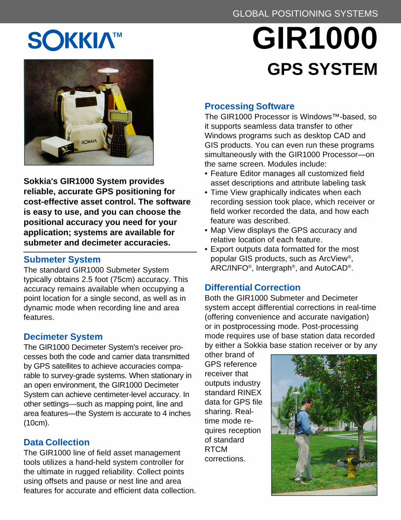
Data CollectionThe GIR1000 line of field asset managementtools utilizes a hand-held system controller forthe ultimate in rugged reliability. Collect pointsusing offsets and pause or nest line and areafeatures for accurate and efficient data collection.
Processing SoftwareThe GIR1000 Processor is Windows™-based, soit supports seamless data transfer to otherWindows programs such as desktop CAD andGIS products. You can even run these programssimultaneously with the GIR1000 Processor—onthe same screen. Modules include:• Feature Editor manages all customized field
asset descriptions and attribute labeling task• Time View graphically indicates when each
recording session took place, which receiver orfield worker recorded the data, and how eachfeature was described.
• Map View displays the GPS accuracy andrelative location of each feature.
• Export outputs data formatted for the mostpopular GIS products, such as ArcView®,ARC/INFO®, Intergraph®, and AutoCAD®.
Differential CorrectionBoth the GIR1000 Submeter and Decimetersystem accept differential corrections in real-time(offering convenience and accurate navigation)or in postprocessing mode. Post-processingmode requires use of base station data recordedby either a Sokkia base station receiver or by anyother brand ofGPS referencereceiver thatoutputs industrystandard RINEXdata for GPS filesharing. Real-time mode re-quires receptionof standardRTCMcorrections.
SOKKIA GIR1000GPS SYSTEM
GLOBAL POSITIONING SYSTEMS
Sokkia's GIR1000 System providesreliable, accurate GPS positioning forcost-effective asset control. The softwareis easy to use, and you can choose thepositional accuracy you need for yourapplication; systems are available forsubmeter and decimeter accuracies.
TM

System Accuracy (RMS)• Submeter: 2.5 ft. (75cm) instantaneous/static or
dynamic; 1.6 ft. (50cm) with 1 min. occupation• Decimeter: 11.8 in. (30cm) static or dynamic when
satellite lock is maintained for > 5 min.; 4 in.(1Ocm) static or dynamic when satellite lock ismaintained for > 20 min.; 0.4 in. (1cm) with optionalsoftware, static or dynamic when satellite lock ismaintained for > 45 min.
Accuracies assume PDOP<4, minimum of 5 satel-lites. Obstructions from building/foliage, highmultipath areas and periods of strong ionosphericfluctuations will degrade accuracies.
Equipment and Accessories• Standard: 12 channel "all-in-view" GPS receiver,
compact GPS antenna, rugged backpack carryingsystem, 2 rechargeable receiver batteries for 12-hr.operation, battery charger (120 VAC input), multi-use data cable, magnetic mount; (Decimeter sys-tem also includes hard-shell carrying case. 2-meterrange pole, controller bracket, and point)
• Optional: HUSKY FS/2™ hand-held controller withFAMLOG™ software; (Submeter system also hasan optional hard-shell carrying case, 2-meter rangepole and point)
GIR1000 Processor Software Capabilities• Pre-mission planning for satellite availability• Feature file creation/editing for customizing feature
and attribute libraries• Waypoint Editor• Data transfer• Data collection session management• Differential correction of GPS data• Time View for displaying when field units were
collecting data• Map View for displaying position and feature data• Datum conversion and coordinate transformation• RINEX conversion• Database, CAD and GIS formatting
GIR1000 GPS Receiver• Tracking: 12 parallel channels, L1 C/A code (carrier
optional)• Size: 1.9" H x 3.7" W x 6.5" D (4.8cm H x 9.4cm W
x 16.5cm D)• Weight: 1.5 lbs. (0.68kg)• Power: 6-15 VDC, 3.5 watts• Temperatures: Operating -4° to +131°F (-20° to
+55°C); Storage -22° to +167°F (-30° to +75°C)• Memory: 4.5Mb (up to 40 hrs of 6 satellite data at 5
sec. intervals, or 8 hrs at 1 sec. intervals)• Update Rate: selectable 1-999 sec.• Warranty: 1 year (extended warranty available)
Marine IV GPS Antenna (microstrip)• Size: 7" Dia. x 3" H (17.8cm Dia. x 7.6cm H)• Weight: 0.9 lbs. (0.4kg)• Temperatures: Operating and Storage -40° to
+160°F (-40° to +71 °C)Impervious to wind-driven rain and dust
HUSKY FS/2 Controller• General: MS-DOS based hand-held computer, 8-
line x 40-character backlit LCD screen, separatealpha and numeric keypads, die-cast magnesiumalloy case
• Size: 9.3" x 5" x 1.7" (23.6cm x 12.7cm x 4.3cm)• Weight: 1.6 lbs. (0.7kg)• Temperatures: Operating -22° to +130°F (-30° to
+55°C); Storage -22° to +140°F (-30 to +60°C)Waterproof against accidental immersion.Designed to withstand 6 ft. (2m) drop.
GIR1000 Specifications
SOKKIA CORPORATION9111 Barton, Box 2934Overland Park, KS 66201 USATel: 1-800-4-SOKKIA or (913) 492-4900Fax: (913) 492-0188
© 1996 Sokkia Corporation. Sokkia is a trademark of Sokkia. Windows is a trademark of Microsoft Corporation. ArcView and ARC/INFO are registered trademarks of Environmental Systems Research Institute, Inc. AutoCAD is a registered trademark of AutoDesk,Inc. Intergraph is a registered trademark of Intergraph Corporation. Husky FS/2 is a trademark of Husky Computers Inc. Marine IVand FAMLOG are trademarks of Ashtech, Inc.
Design and specifications are subject to change without notice.