Embed Size (px)
Citation preview
AIG Journal – Applied geoscientific research and practice in Australia
Paper 2000-05 April 2000 1
GIS LINKING TO EXTERNAL DATA SETS AND PROCESSES
Ken Moule
Exa-Min Resource Industry Consultants Pty Ltd
ABSTRACT
This paper investigates models for management of extended Geosciences data sets, based on experience collating historic and current data sets to build a three dimensional model of the Gympie Eldorado Mine. Rather than migrate all data to restrictive GIS data structures, the consultants integrated a range of specialist and “off-the-shelf” applications, into a unified data management model. The GeoBasemap MapLinker product is being deployed to provide active, two-way links between the MapInfo GIS and third party applications. This model accommodates extended data types such as images, word processor documents and spreadsheets, as well as managing interaction with sensitive data via database forms, rather than allowing uncontrolled edit of attributes through traditional GIS interfaces. Exa-Min’s experience in managing the complex Gympie data set has led to further refinement of the MapLinker product, that is now being deployed in the wider GIS community.
INTRODUCTION
On behalf of Gympie Gold (formerly Devex Pty Ltd), Exa-Min is building a three dimensional model of all current and historic workings. While the primary work process is digitising of mine layouts from plan, and building these into three dimensional models, project management and due diligence has required maintenance of a database of all plans, and provision of hot-link between GIS and database representation of those plans. The project leverages off both and GIS and database technologies, and is building towards a total geosciences and mine information management system.
Historically the Gympie Goldfield was a very significant gold producer. The field provided the economic backbone that underpinned Queensland’s transition to statehood. Over a 60-year period, more than three million ounces of gold was produced from many hundreds of shafts, many of them reaching depths of over 500 metres.
Two styles of orebody have been identified. The bulk of historic production came from “Gympie Veins” emplaced at the intersection of a vertical fault set with carbonaceous sedimentary horizons. These small but persistent structures typically return head grades of around 25 grams per tonne. Larger scale but lower grade mineralisation is emplaced along the Inglewood fault and associated peel-off structures.
Major exploration work and shaft renovation, was carried out by BHP and by Freeport in the period 1980 to 1991, under farm out arrangement. The project reverted back to Gympie Gold, who are now successfully producing gold from both Inglewood and Gympie vein structures.
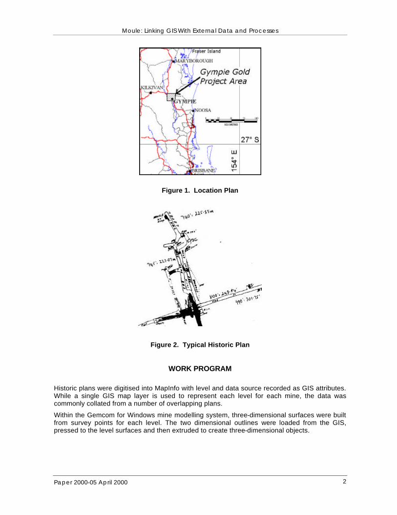
Exa-Min has been involved in the project for over two years. The three dimensional model was commissioned, both to identify exploration targets, and to minimise the hazards that could arise were the mine to unexpectedly breach abandoned workings. The primary data set is a collection of almost 500 historic plans, many dating back to before the turn of the century.
Moule: Linking GIS With External Data and Processes
Paper 2000-05 April 2000 2
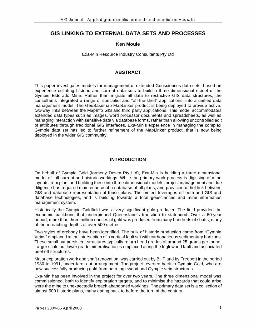
Figure 1. Location Plan
Figure 2. Typical Historic Plan
WORK PROGRAM
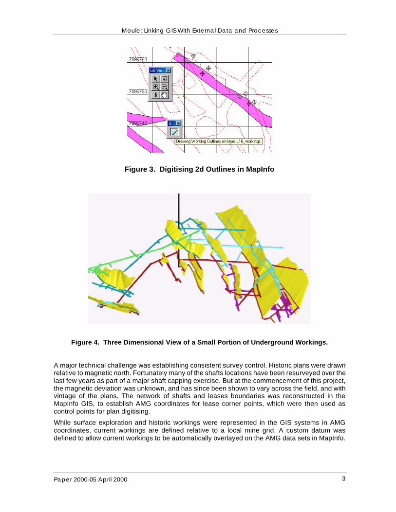
Historic plans were digitised into MapInfo with level and data source recorded as GIS attributes. While a single GIS map layer is used to represent each level for each mine, the data was commonly collated from a number of overlapping plans.
Within the Gemcom for Windows mine modelling system, three-dimensional surfaces were built from survey points for each level. The two dimensional outlines were loaded from the GIS, pressed to the level surfaces and then extruded to create three-dimensional objects.
Moule: Linking GIS With External Data and Processes
Paper 2000-05 April 2000 3
Figure 3. Digitising 2d Outlines in MapInfo
Figure 4. Three Dimensional View of a Small Portion of Underground Workings.
A major technical challenge was establishing consistent survey control. Historic plans were drawn relative to magnetic north. Fortunately many of the shafts locations have been resurveyed over the last few years as part of a major shaft capping exercise. But at the commencement of this project, the magnetic deviation was unknown, and has since been shown to vary across the field, and with vintage of the plans. The network of shafts and leases boundaries was reconstructed in the MapInfo GIS, to establish AMG coordinates for lease corner points, which were then used as control points for plan digitising.
While surface exploration and historic workings were represented in the GIS systems in AMG coordinates, current workings are defined relative to a local mine grid. A custom datum was defined to allow current workings to be automatically overlayed on the AMG data sets in MapInfo.
Moule: Linking GIS With External Data and Processes
Paper 2000-05 April 2000 4
TECHNOLOGIES
The Gympie GIS database now contains over 1000 data layers. Managing and documenting these layers and the plans from which they were digitised, escalates the project into the realms of a serious IT data management exercise, even before you add the potential for other Geoscience data sets such as face mapping, drilling, and imagery.
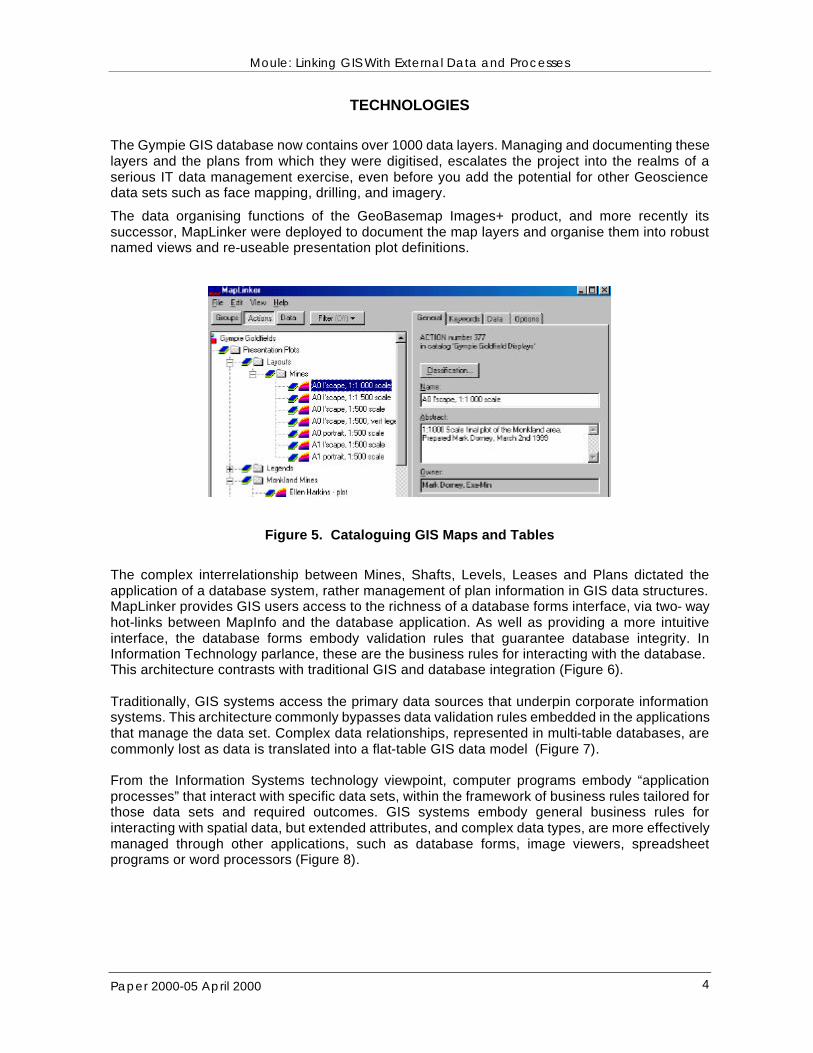
The data organising functions of the GeoBasemap Images+ product, and more recently its successor, MapLinker were deployed to document the map layers and organise them into robust named views and re-useable presentation plot definitions.
Figure 5. Cataloguing GIS Maps and Tables
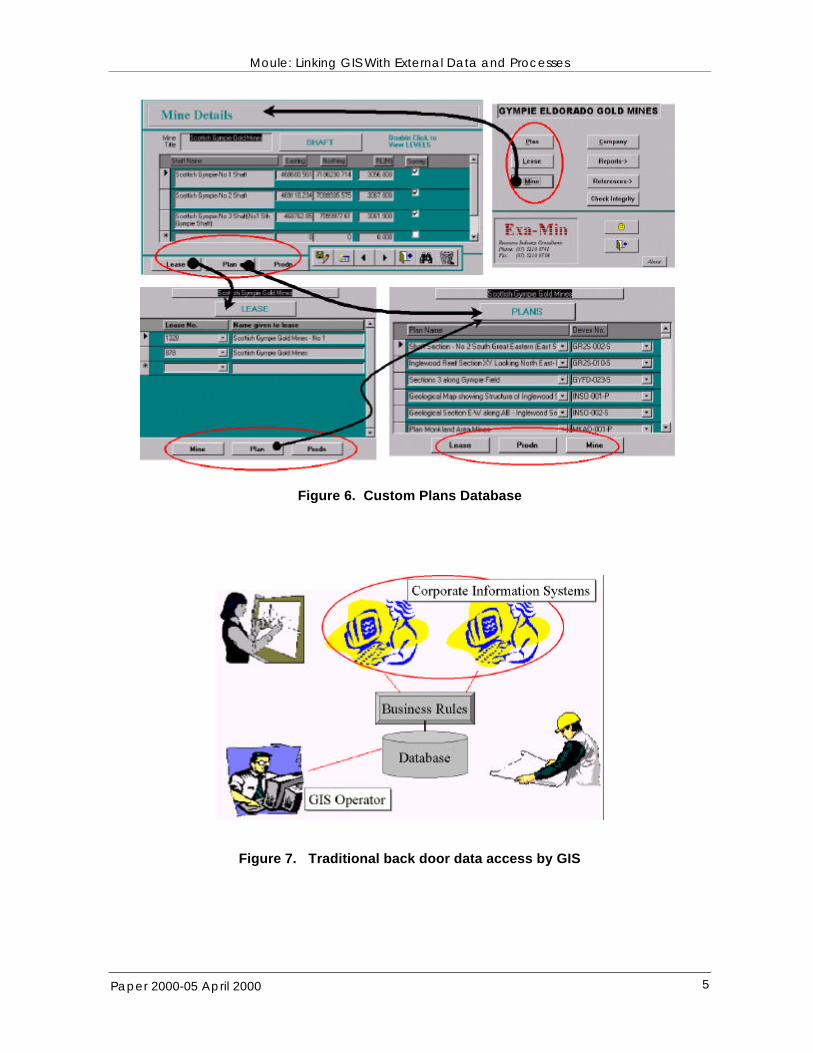
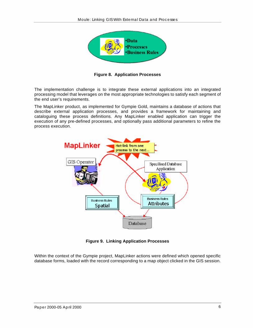
The complex interrelationship between Mines, Shafts, Levels, Leases and Plans dictated the application of a database system, rather management of plan information in GIS data structures. MapLinker provides GIS users access to the richness of a database forms interface, via two- way hot-links between MapInfo and the database application. As well as providing a more intuitive interface, the database forms embody validation rules that guarantee database integrity. In Information Technology parlance, these are the business rules for interacting with the database. This architecture contrasts with traditional GIS and database integration (Figure 6). Traditionally, GIS systems access the primary data sources that underpin corporate information systems. This architecture commonly bypasses data validation rules embedded in the applications that manage the data set. Complex data relationships, represented in multi-table databases, are commonly lost as data is translated into a flat-table GIS data model (Figure 7). From the Information Systems technology viewpoint, computer programs embody “application processes” that interact with specific data sets, within the framework of business rules tailored for those data sets and required outcomes. GIS systems embody general business rules for interacting with spatial data, but extended attributes, and complex data types, are more effectively managed through other applications, such as database forms, image viewers, spreadsheet programs or word processors (Figure 8).
Moule: Linking GIS With External Data and Processes
Paper 2000-05 April 2000 5
Figure 6. Custom Plans Database
Figure 7. Traditional back door data access by GIS
Moule: Linking GIS With External Data and Processes
Paper 2000-05 April 2000 6
Figure 8. Application Processes The implementation challenge is to integrate these external applications into an integrated processing model that leverages on the most appropriate technologies to satisfy each segment of the end user’s requirements.
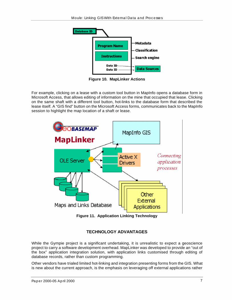
The MapLinker product, as implemented for Gympie Gold, maintains a database of actions that describe external application processes, and provides a framework for maintaining and cataloguing these process definitions. Any MapLinker enabled application can trigger the execution of any pre-defined processes, and optionally pass additional parameters to refine the process execution.
Figure 9. Linking Application Processes
Within the context of the Gympie project, MapLinker actions were defined which opened specific database forms, loaded with the record corresponding to a map object clicked in the GIS session.
Moule: Linking GIS With External Data and Processes
Paper 2000-05 April 2000 7
Figure 10. MapLinker Actions
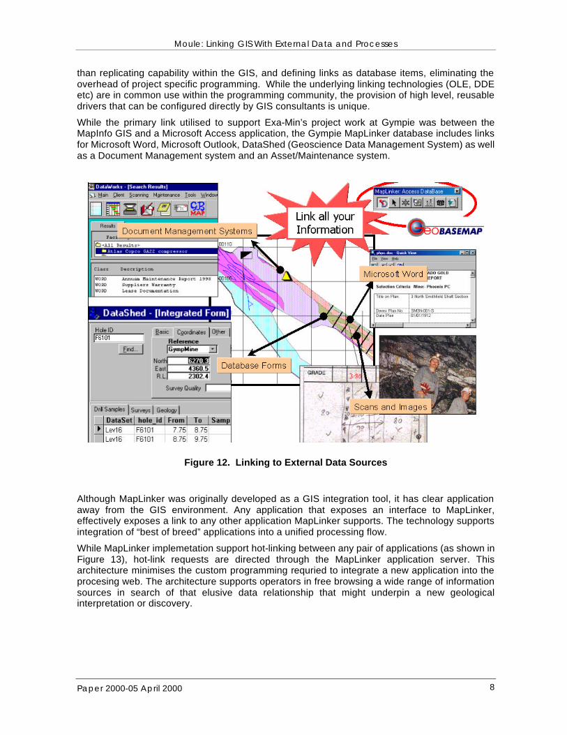
For example, clicking on a lease with a custom tool button in MapInfo opens a database form in Microsoft Access, that allows editing of information on the mine that occupied that lease. Clicking on the same shaft with a different tool button, hot-links to the database form that described the lease itself. A “GIS find” button on the Microsoft Access forms, communicates back to the MapInfo session to highlight the map location of a shaft or lease.
Figure 11. Application Linking Technology
TECHNOLOGY ADVANTAGES
While the Gympie project is a significant undertaking, it is unrealistic to expect a geoscience project to carry a software development overhead. MapLinker was developed to provide an “out of the box” application integration solution, with application links customised through editing of database records, rather than custom programming.
Other vendors have trialed limited hot-linking and integration presenting forms from the GIS. What is new about the current approach, is the emphasis on leveraging off external applications rather
Moule: Linking GIS With External Data and Processes
Paper 2000-05 April 2000 8
than replicating capability within the GIS, and defining links as database items, eliminating the overhead of project specific programming. While the underlying linking technologies (OLE, DDE etc) are in common use within the programming community, the provision of high level, reusable drivers that can be configured directly by GIS consultants is unique.
While the primary link utilised to support Exa-Min’s project work at Gympie was between the MapInfo GIS and a Microsoft Access application, the Gympie MapLinker database includes links for Microsoft Word, Microsoft Outlook, DataShed (Geoscience Data Management System) as well as a Document Management system and an Asset/Maintenance system.
Figure 12. Linking to External Data Sources
Although MapLinker was originally developed as a GIS integration tool, it has clear application away from the GIS environment. Any application that exposes an interface to MapLinker, effectively exposes a link to any other application MapLinker supports. The technology supports integration of “best of breed” applications into a unified processing flow.
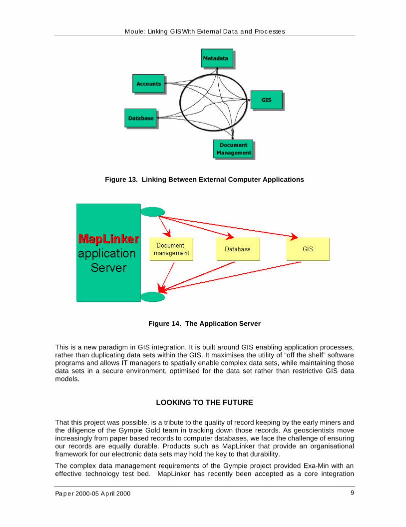
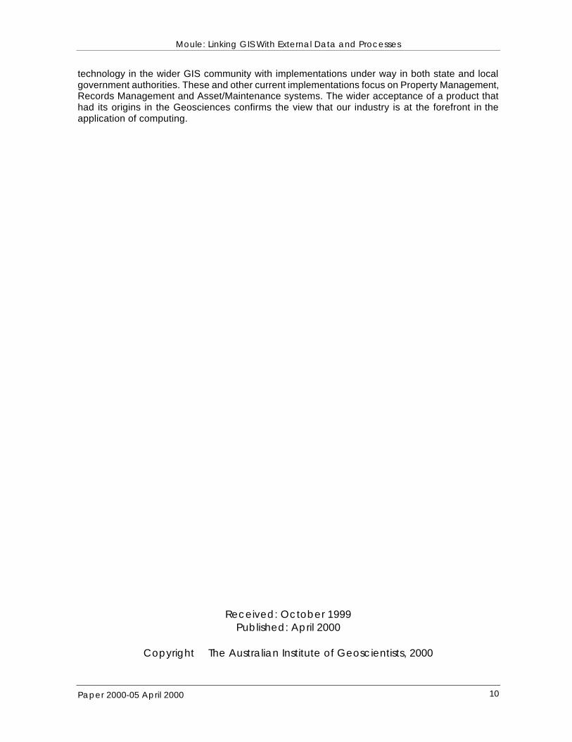
While MapLinker implemetation support hot-linking between any pair of applications (as shown in Figure 13), hot-link requests are directed through the MapLinker application server. This architecture minimises the custom programming requried to integrate a new application into the procesing web. The architecture supports operators in free browsing a wide range of information sources in search of that elusive data relationship that might underpin a new geological interpretation or discovery.
Moule: Linking GIS With External Data and Processes
Paper 2000-05 April 2000 9
Figure 13. Linking Between External Computer Applications
Figure 14. The Application Server
This is a new paradigm in GIS integration. It is built around GIS enabling application processes, rather than duplicating data sets within the GIS. It maximises the utility of “off the shelf” software programs and allows IT managers to spatially enable complex data sets, while maintaining those data sets in a secure environment, optimised for the data set rather than restrictive GIS data models.
LOOKING TO THE FUTURE
That this project was possible, is a tribute to the quality of record keeping by the early miners and the diligence of the Gympie Gold team in tracking down those records. As geoscientists move increasingly from paper based records to computer databases, we face the challenge of ensuring our records are equally durable. Products such as MapLinker that provide an organisational framework for our electronic data sets may hold the key to that durability.
The complex data management requirements of the Gympie project provided Exa-Min with an effective technology test bed. MapLinker has recently been accepted as a core integration
Moule: Linking GIS With External Data and Processes
Paper 2000-05 April 2000 10
technology in the wider GIS community with implementations under way in both state and local government authorities. These and other current implementations focus on Property Management, Records Management and Asset/Maintenance systems. The wider acceptance of a product that had its origins in the Geosciences confirms the view that our industry is at the forefront in the application of computing.
Received: October 1999 Published: April 2000
Copyright The Australian Institute of Geoscientists, 2000