Embed Size (px)
Citation preview
Gorgon Gas Development Fourth Train Expansion Project, Geophysical and Geotechnical Site Survey Page 1 Environment Plan Public Summary
GEOPHYSICAL AND GEOTECHNICAL SITE SURVEY
GORGON GAS DEVELOPMENT FOURTH TRAIN EXPANSION PROJECT ENVIRONMENT PLAN: PUBLIC SUMMARY
This summary of the Environment Plan for the Gorgon Gas Development Fourth Train Expansion Project Geophysical and Geotechnical Site Survey, which will be acquired on the North West Shelf (NWS) offshore from Western Australia (WA), has been submitted to the National Offshore Petroleum Safety and Environmental Management Authority (NOPSEMA), to comply with Regulations 11(7) and 11(8) of the Offshore Petroleum and Greenhouse Gas Storage (Environment) Regulations 2009.
INTRODUCTION
The geophysical and geotechnical survey company Fugro Survey Pty Ltd proposes to undertake a geophysical and geotechnical site survey (Geophysical and Geotechnical Site Survey, Gorgon Gas Development Fourth Train Expansion Project), on the NWS offshore from WA. The proposed geophysical and geotechnical site survey comprise both shallow and deep water components in Commonwealth waters offshore from Barrow Island (Figure 1), and will be conducted to support marine aspects of Chevron’s Gorgon Gas Development Fourth Train Expansion Project. The key objective of the site survey is to gather sufficient geophysical and geotechnical information to provide Chevron with detailed data for the design and location of subsea structures and pipelines. The geophysical and geotechnical site survey is scheduled to occur in the period between November 2012 and April 2013, with expected durations of approximately eight weeks for the geophysical fieldwork and 12 weeks for the geotechnical fieldwork.
COORDINATES OF THE PROPOSED ACTIVITY
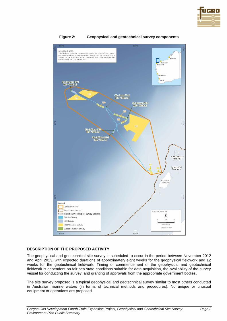
The proposed geophysical and geotechnical site survey will take place within a number of areas associated with the Gorgon Gas Development Fourth Train Expansion Project in Commonwealth waters on the NWS, offshore from Barrow Island, WA. This will include both shallow water (water depth range 25-200 m) and deep-water (water depth range 200-1,397 m) components (Figure 1). Data acquisition will take place in an operational area that covers ~7,180 km
2, which overlaps parts of 35 petroleum titles. Boundary coordinates
for the operational area polygon, which encompasses all of the proposed site survey areas (Figure 2), are provided in Table 1 below.
Table 1: Geophysical and geotechnical site survey operational area – boundary coordinates
Point Latitude (S) Longitude (E)
Degrees Minutes Seconds Degrees Minutes Seconds
A 19 46 36.01 114 05 02.95
B 19 46 36.01 114 02 09.59
C 19 32 46.39 114 03 12.34
D 19 31 09.25 114 07 14.08
E 19 30 38.22 114 10 55.72
F 19 35 21.82 114 30 04.17
G 19 58 10.57 115 11 22.77
H 20 40 14.11 115 20 56.38
I 20 41 58.54 115 12 26.84
J 20 38 13.24 115 07 28.03
K 20 11 18.58 114 41 20.16
Datum: WGS84

Gorgon Gas Development Fourth Train Expansion Project, Geophysical and Geotechnical Site Survey Page 2 Environment Plan Public Summary
Figure 1: Location map – geophysical and geotechnical site survey, Gorgon Gas Development Fourth Train Expansion Project
At the closest point (Point H – see Figure 1), the geophysical and geotechnical site operational area is situated at a minimum distance of approximately 1.2 km from the WA State waters boundary, and approximately 7.3 km from the west coast of Barrow Island. All components of the operational area are located in Commonwealth waters. At the closest point, the inshore components of the operational area located approximately 6.5 km from the northern boundary of the Barrow Island Marine Park, and approximately 1.2 km from the boundary of the Barrow Island Marine Management Area. Water depths in the operational area range from ~25-1,397 m. There are no emergent features or shallow shoals or banks within the operational area (Figure 1).
Gorgon Gas Development Fourth Train Expansion Project, Geophysical and Geotechnical Site Survey Page 3 Environment Plan Public Summary
Figure 2: Geophysical and geotechnical survey components
DESCRIPTION OF THE PROPOSED ACTIVITY
The geophysical and geotechnical site survey is scheduled to occur in the period between November 2012 and April 2013, with expected durations of approximately eight weeks for the geophysical fieldwork and 12 weeks for the geotechnical fieldwork. Timing of commencement of the geophysical and geotechnical fieldwork is dependent on fair sea state conditions suitable for data acquisition, the availability of the survey vessel for conducting the survey, and granting of approvals from the appropriate government bodies. The site survey proposed is a typical geophysical and geotechnical survey similar to most others conducted in Australian marine waters (in terms of technical methods and procedures). No unique or unusual equipment or operations are proposed.
Gorgon Gas Development Fourth Train Expansion Project, Geophysical and Geotechnical Site Survey Page 4 Environment Plan Public Summary
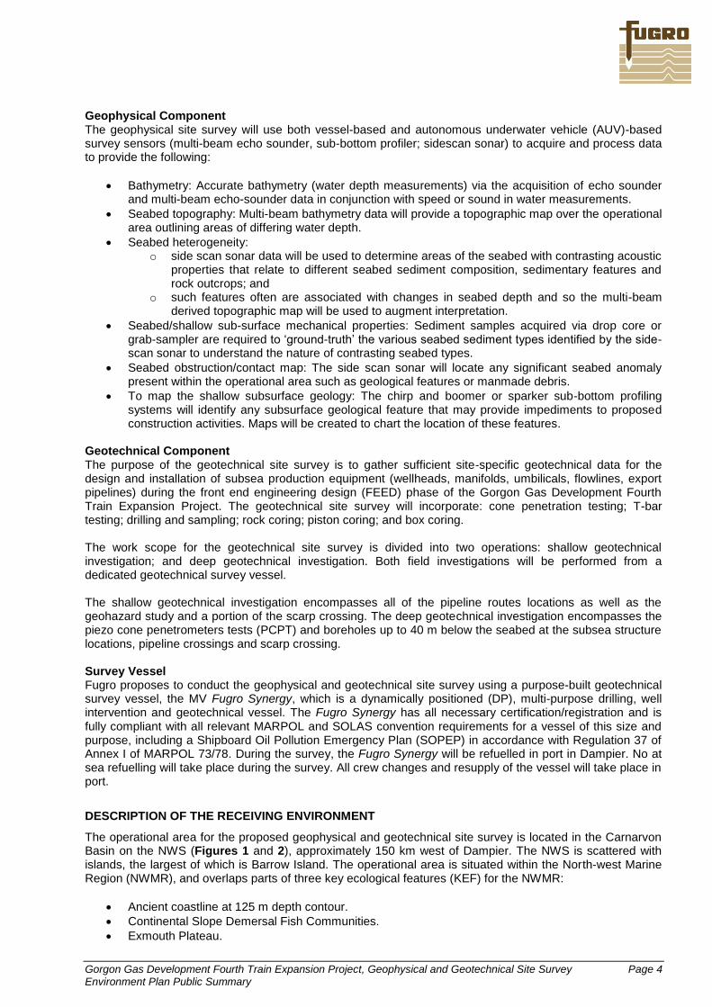
Geophysical Component The geophysical site survey will use both vessel-based and autonomous underwater vehicle (AUV)-based survey sensors (multi-beam echo sounder, sub-bottom profiler; sidescan sonar) to acquire and process data to provide the following:
Bathymetry: Accurate bathymetry (water depth measurements) via the acquisition of echo sounder and multi-beam echo-sounder data in conjunction with speed or sound in water measurements.
Seabed topography: Multi-beam bathymetry data will provide a topographic map over the operational area outlining areas of differing water depth.
Seabed heterogeneity: o side scan sonar data will be used to determine areas of the seabed with contrasting acoustic
properties that relate to different seabed sediment composition, sedimentary features and rock outcrops; and
o such features often are associated with changes in seabed depth and so the multi-beam derived topographic map will be used to augment interpretation.
Seabed/shallow sub-surface mechanical properties: Sediment samples acquired via drop core or grab-sampler are required to ‘ground-truth’ the various seabed sediment types identified by the side-scan sonar to understand the nature of contrasting seabed types.
Seabed obstruction/contact map: The side scan sonar will locate any significant seabed anomaly present within the operational area such as geological features or manmade debris.
To map the shallow subsurface geology: The chirp and boomer or sparker sub-bottom profiling systems will identify any subsurface geological feature that may provide impediments to proposed construction activities. Maps will be created to chart the location of these features.
Geotechnical Component The purpose of the geotechnical site survey is to gather sufficient site-specific geotechnical data for the design and installation of subsea production equipment (wellheads, manifolds, umbilicals, flowlines, export pipelines) during the front end engineering design (FEED) phase of the Gorgon Gas Development Fourth Train Expansion Project. The geotechnical site survey will incorporate: cone penetration testing; T-bar testing; drilling and sampling; rock coring; piston coring; and box coring. The work scope for the geotechnical site survey is divided into two operations: shallow geotechnical investigation; and deep geotechnical investigation. Both field investigations will be performed from a dedicated geotechnical survey vessel. The shallow geotechnical investigation encompasses all of the pipeline routes locations as well as the geohazard study and a portion of the scarp crossing. The deep geotechnical investigation encompasses the piezo cone penetrometers tests (PCPT) and boreholes up to 40 m below the seabed at the subsea structure locations, pipeline crossings and scarp crossing. Survey Vessel Fugro proposes to conduct the geophysical and geotechnical site survey using a purpose-built geotechnical survey vessel, the MV Fugro Synergy, which is a dynamically positioned (DP), multi-purpose drilling, well intervention and geotechnical vessel. The Fugro Synergy has all necessary certification/registration and is fully compliant with all relevant MARPOL and SOLAS convention requirements for a vessel of this size and purpose, including a Shipboard Oil Pollution Emergency Plan (SOPEP) in accordance with Regulation 37 of Annex I of MARPOL 73/78. During the survey, the Fugro Synergy will be refuelled in port in Dampier. No at sea refuelling will take place during the survey. All crew changes and resupply of the vessel will take place in port.
DESCRIPTION OF THE RECEIVING ENVIRONMENT
The operational area for the proposed geophysical and geotechnical site survey is located in the Carnarvon Basin on the NWS (Figures 1 and 2), approximately 150 km west of Dampier. The NWS is scattered with islands, the largest of which is Barrow Island. The operational area is situated within the North-west Marine Region (NWMR), and overlaps parts of three key ecological features (KEF) for the NWMR:
Ancient coastline at 125 m depth contour.
Continental Slope Demersal Fish Communities.
Exmouth Plateau.

Gorgon Gas Development Fourth Train Expansion Project, Geophysical and Geotechnical Site Survey Page 5 Environment Plan Public Summary
Physical Environment The Pilbara Region is characterised by two seasons: summer (September–April) and winter (May–August). The southern portion of the NWS region, including Barrow Island, is characterised by an arid, subtropical climate. In summer, mean daily temperatures range between 20°C and 34°C. During winter, mean daily temperatures range between 17°C and 26°C. Relative humidity at Barrow Island ranges from 61% in the winter months (September) to 70% in the summer (February). Meteorological records from Barrow Island are detailed and are likely to be indicative for the region. Given its position in relation to the operational area, meteorological conditions on Barrow Island are considered to provide a good proxy for conditions likely to be encountered in the operational area. Rainfall on Barrow Island varies significantly each year and is dependent on rain-bearing low-pressure systems, thunderstorm activity, and the passage of tropical cyclones (which generally occur from November to April). Average annual rainfall at Barrow Island is 306 mm with most rain (85%) occurring between January and July. The mean ambient wind speed around Barrow Island during summer is 6.6 m/s, and the maximum summer wind speed is 16.2 m/s. The dominant wind directions during summer are from the south-west and west. During winter, winds approach from the east, south, and south-west and have a mean speed of 5.8 m/s and a maximum speed of 19.4 m/s. An average of five tropical cyclones per year occur in the Pilbara Region, with an average of two per year passing through the Barrow Island area. According to the Bureau of Meteorology, the Australian tropical cyclone season runs from 1 November to 30 April, with cyclones most common between December and March. Tropical cyclones are unpredictable in occurrence, intensity, and behaviour and can generate extreme seas and swell. Large increases in precipitation are associated with cyclones, and the Bureau of Meteorology reports that rainfall totals greater than 100 mm are common with tropical lows that move over land. In the deep waters of the operational area, water temperatures at depths greater than 500 m range from a summer peak of approximately 10°C to a winter low of about 4°C. The mean temperature for depths between 200 and 250 m is approximately 10°C. Surface water temperatures offshore range between approximately 20°C in winter and 31°C in summer. Water circulation in the region is influenced by the southward-flowing Leeuwin Current and the Indonesian Throughflow. Currents in the operational area are principally driven by semidiurnal tidal forcing. The direction of tidal currents is a flood flow towards the south-west and an ebb flow towards the north-east. Local winds can influence water circulation, more so in the upper 200 m of the water column. Maximum current speeds in upper regions of the water column (surface to 100 m deep) near the operational area are predicted to range from 0.33 to 0.8 m/s in non-cyclonic conditions and may occasionally approach 1.1 m/s under extreme storm conditions. The region typically experiences a persistent winter swell of around 2 m, generated by low-pressure systems in southern latitudes. During winter, strong easterly winds can also generate 2 m seas. Both swell and seas tend to be smaller during summer. Astronomical tides on the NWS are semidiurnal and generally quite large, ranging from 0.95 m near Exmouth to more than 3 m on the inner shelf near Broome. Maximum spring tide amplitudes range from just over 2 m at Exmouth, 2.5 m at Onslow, 4.5 m at Dampier, to nearly 6 m at Port Hedland. The continental slope (the scarp), extends from 300 m to 1,200 m water depth and is divided into an upper, middle and lower slope based on distinctive changes in the seabed gradient and morphology. At the base of the scarp, maximum seabed slopes of up to 80° can be found. Average slopes in the upper scarp are 4° to 5°, while the average slope of the middle and lower scarp is more benign (2° to 5°). Biological Environment The operational area for the geophysical and geotechnical site survey includes deep-water environments (up to 1,397 m deep) at the most north-easterly point in the adjacent to the Io/Jansz gas field and, closer to Barrow Island, shallow water marine habitats in water as shallow as 25 m. The deep-water habitats of the operational area are generally depauperate and typical of the low abundance, richness and diversity observed in other deep areas of the NWS. However, there are areas of increased infaunal abundance in deeper water depths, as evidenced by areas of heavily bioturbated sediments, indicating an active infaunal assemblage (see below). Benthic surveys conducted in depths ranging from 212 m to more than 1,300 m, showed that no epifauna (i.e. fauna living on the seabed) were recorded from the majority of samples (63%) and infauna, where present, were in low abundance, with low richness and

Gorgon Gas Development Fourth Train Expansion Project, Geophysical and Geotechnical Site Survey Page 6 Environment Plan Public Summary
diversity. Surveys conducted in the scarp region found that the soft sediment in the area was often marked by burrow holes made by unidentified organisms (thought to be small fish or crustaceans); these soft sediments supported some benthic life, including solitary sea pens, holothurians, and hydroids. Soft corals were present and were found to be most abundant at depths between approximately 550 and 700 m, with Alcyonian soft corals being the most common taxa identified. At these sites, the soft corals were found in mixed communities with bryozoans, sponges, and hydroids. The benthic habitats in State waters off the west coast of Barrow Island largely comprise unvegetated or bare sand, or alternatively, sand covering a gently sloping limestone pavement. Macroalgae cover represents the dominant ecological element and the dominant habitat assemblage in the shallow State Waters off the west coast of Barrow Island, with macroalgal taxa common within the local area and the Pilbara Region. Corals in the area are present in low abundances and only sparsely scattered colonies of species such as the hard coral Turbinaria spp. were recorded. Coral reefs are limited to the southern and central parts of the west coast. Biggada Reef on the central west coast of Barrow Island is an extensive, largely intertidal coral reef that extends to the subtidal zone. Two rocky reef sections occur approximately 25 km and 12 km from Barrow Island, in 50–55 m and 40 m water depths, respectively. The inner platform reef supports scattered corals and sponges, although the area is too deep to support well-developed benthic primary producer assemblages. The outer reef supports encrusting sponges and scattered deep water coral. Small, sparse patches of seagrass occur on sand veneers at a few locations in shallow waters on the west coast of Barrow Island and at low levels of percentage cover, growing in mixed assemblages with macroalgae and occasionally benthic macroinvertebrates. No mangroves were recorded on the west coast of Barrow Island. Small pelagic fish are believed to comprise a significant proportion of the fish biomass throughout the region, feeding on pelagic phytoplankton and zooplankton and providing a food source for a wide variety of predators including large pelagic fish, sharks, seabirds, and marine mammals. Fish species of the inner shelf include lizardfish, goatfish, trevally, angelfish, and tuskfish. Large pelagic fish (such as tuna, deep lizardfish, deep goatfish, ponyfish, deep threadfin bream, adult trevally, billfish, mackerel, swordfish, and marlin) are also found in the region, mainly in water depths of 100 to 200 m, and occasionally on the continental shelf. The region also contains a rich variety of chondrichthyan fish (sharks, skates and rays), which occupy a broad range of shallow and deep-water habitats, as well as being distributed throughout the water column. The NWS region is associated with important populations of demersal fish species, including commercial species such as snappers, emperors, and groupers, which are distributed across a number of distinct depth ranges, specifically areas of the upper slope (225–500 m water depth) and mid slope (750–1,000 m water depth). More than 508 fish species have been identified on the slope in this area, of which 64 species are endemic. Demersal fish surveys were undertaken off the west coast of Barrow Island as part of the Gorgon Foundation Project, in macroalgal, soft sediments with sessile non-coral benthic macroinvertebrates, and unvegetated sand communities. These surveys were undertaken in water depths between 12 and 22 m. During the first survey in March 2009, a total of 698 individuals from 58 species and 28 families were recorded; in February/March 2010, 1,266 individuals from 71 species and 31 families were recorded. The results from surveys undertaken in 2008 and 2009 indicated that different shallow water marine habitats surrounding Barrow Island were generally characterised by different species compositions and richness. Elasmobranch species, including sharks and possibly sawfish, are likely to be present in the geophysical and geotechnical site survey operational area.
Protected Marine Fauna A review of the Environment Protection and Biodiversity Conservation Act 1999 (EPBC Act) database (Protected Matters search tool) held by the Department of Sustainability, Environment, Water, Population and Communities (DSEWPaC) was conducted for the geophysical and geotechnical site survey operational area polygon (Figure 2). The 10 listed Threatened species that may occur in, or relate to, the operational area are:
1. the southern giant petrel; 2. the blue whale; 3. the humpback whale; 4. the short-nosed sea snake

Gorgon Gas Development Fourth Train Expansion Project, Geophysical and Geotechnical Site Survey Page 7 Environment Plan Public Summary
5. the loggerhead turtle; 6. the green turtle; 7. the leatherback turtle; 8. the hawksbill turtle; 9. the flatback turtle; and 10. the whale shark.
The operational area is not considered a habitat that is critical to the survival of any listed species. Similarly, there are no EPBC Act-listed threatened ecological communities (TECs) in the vicinity of the operational area. Whales and Dolphins The EPBC Act database lists 26 cetacean species that may occur in, or may relate to, the operational area, all of which are protected under the Act; one of which is also classified as Endangered, one as Vulnerable and eight as Migratory species. There are no known feeding or breeding areas for these listed species within the geophysical and geotechnical site survey operational area, so these species are likely to be transient. Humpback whales are regular visitors to Pilbara offshore waters, moving through Barrow Island waters between June and October on their annual migration between their feeding grounds in Antarctic waters and their calving grounds in the more northerly Pilbara and Kimberley waters. Northbound humpback whales tend to remain on or within 200 m water depth, while southbound whales tend to come closer to Barrow Island, generally occurring between 50 m and 200 m water depth. Humpback whales are more common in waters off the west coast of Barrow Island (Figure 3), but also visit the east coast. Another species of whale that may be occur in, or relate to, the operational area as indicated from the EPBC Act database search is the blue whale. Blue whales are widely distributed throughout the worlds’ oceans. This species has been recorded offshore in all states excluding the Northern Territory. Their migration paths are widespread and do not clearly follow coastlines or particular oceanographic features. The blue whale is rarely present in large numbers outside recognised aggregation areas. Blue whales are believed to calve in tropical waters in winter and births peak in May to June, however the exact breeding grounds of this species are unknown. The operational area and adjacent waters do not include any known blue whale feeding, breeding or resting areas. In the NWMR, pygmy blue whales migrate along the 500 m to 1,000 m depth contour on the edge of the slope, and are likely to be feeding on ephemeral krill aggregations. The northward component of this migration takes place from May to mid-August, with a peak in July-August, and the southward component occurs from late October to November-December, with a few isolated individuals moving south in January. The migration appears to be centred on the 500 m depth contour. Consequently, it is possible that blue whales may be encountered in the operational area and adjacent waters, given the proposed survey timing and the water depth range in the deeper parts of the operational area (200-1,397 m). Other cetacean species whose broad distributions cover the region include whales that are infrequently observed usually restricted to cooler or deeper waters (e.g. killer and Bryde’s whales) and are unlikely to be encountered in the operational area during the survey in significant numbers. Sperm whales tend to be found in offshore waters and may occasionally visit the shelf waters offshore of Barrow Island. Dugong Dugong are known to occur around Barrow Island, the Lowendal Islands, and the Montebello Islands. Population estimates suggest that approximately 2,000 individuals of this species occur in the region. Dugong populations are greater in Exmouth Gulf and Shark Bay than around offshore islands. Dugongs have been observed in the shallow waters surrounding Barrow Island, including in the vicinity of the shallower waters of the geophysical and geotechnical site survey operational area. Due to the absence of significant seagrass habitats, dugongs are likely to frequent the operational area only during transit to feeding grounds elsewhere in the Pilbara Region.

Gorgon Gas Development Fourth Train Expansion Project, Geophysical and Geotechnical Site Survey Page 8 Environment Plan Public Summary
Figure 3: Humpback whale migration routes in the vicinity of the operational area for the site survey
Turtles Barrow Island is a regionally important nesting area for green turtles and flatback turtles. Flatback turtle nesting on Barrow Island is concentrated on the mid-east coast on deep, sandy, low-sloped beaches with wide, shallow, intertidal zones. The nesting period for flatback turtles extends from October to March, with a peak nesting period in December and January. Flatback turtle hatchlings emerge from their nests six to eight weeks after eggs are laid. The hatching period occurs from January to April, with the peak hatching period in February and March. The green turtle reproductive population at Barrow Island is estimated at around 20,000 females, comprising an important proportion of the NWS genetic stock. Mating aggregations occur along the west coast of Barrow Island from August to January, with the peak period from September to December. Green turtles tend to nest on the west, north, and north-east coasts of Barrow Island where beaches are high-energy, deep, steeply
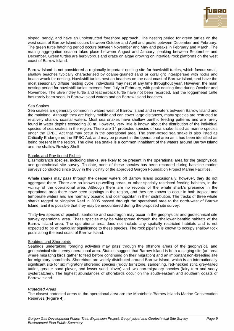
Gorgon Gas Development Fourth Train Expansion Project, Geophysical and Geotechnical Site Survey Page 9 Environment Plan Public Summary
sloped, sandy, and have an unobstructed foreshore approach. The nesting period for green turtles on the west coast of Barrow Island occurs between October and April and peaks between December and February. The green turtle hatching period occurs between November and May and peaks in February and March. The mating aggregation season takes place between August and January, peaking between September and December. Green turtles are herbivorous and graze on algae growing on intertidal rock platforms on the west coast of Barrow Island. Barrow Island is not considered a regionally important nesting site for hawksbill turtles, which favour small, shallow beaches typically characterised by coarse-grained sand or coral grit interspersed with rocks and beach wrack for nesting. Hawksbill turtles nest on beaches on the east coast of Barrow Island, and have the most seasonally diffuse nesting cycle; individuals may nest at any time throughout year. However, the main nesting period for hawksbill turtles extends from July to February, with peak nesting time during October and November. The olive ridley turtle and leatherback turtle have not been recorded, and the loggerhead turtle has rarely been seen, in Barrow Island waters and on Barrow Island beaches. Sea Snakes Sea snakes are generally common in waters west of Barrow Island and in waters between Barrow Island and the mainland. Although they are highly mobile and can cover large distances, many species are restricted to relatively shallow coastal waters. Most sea snakes have shallow benthic feeding patterns and are rarely found in water depths exceeding 30 m. However, very little is known about the distribution of the individual species of sea snakes in the region. There are 14 protected species of sea snake listed as marine species under the EPBC Act that may occur in the operational area. The short-nosed sea snake is also listed as Critically Endangered the EPBC Act, and may be present in the operational area as it has been identified as being present in the region. The olive sea snake is a common inhabitant of the waters around Barrow Island and the shallow Rowley Shelf. Sharks and Ray-finned Fishes Elasmobranch species, including sharks, are likely to be present in the operational area for the geophysical and geotechnical site survey. To date, none of these species has been recorded during baseline marine surveys conducted since 2007 in the vicinity of the approved Gorgon Foundation Project Marine Facilities. Whale sharks may pass through the deeper waters off Barrow Island occasionally; however, they do not aggregate there. There are no known up-welling areas, or other spatially restricted feeding habitats, in the vicinity of the operational area. Although there are no records of the whale shark’s presence in the operational area there have been sightings in the region, and they are known to occur in both tropical and temperate waters and are normally oceanic and cosmopolitan in their distribution. The tracks of three whale sharks tagged at Ningaloo Reef in 2005 passed through the operational area to the north-west of Barrow Island, and it is possible that they may be encountered during the proposed site survey. Thirty-five species of pipefish, seahorse and seadragon may occur in the geophysical and geotechnical site survey operational area. These species may be widespread through the shallower benthic habitats of the Barrow Island area. The operational area does not include any spatially restricted habitats and is not expected to be of particular significance to these species. The rock pipefish is known to occupy shallow rock pools along the east coast of Barrow Island. Seabirds and Shorebirds Seabirds undertaking foraging activities may pass through the offshore areas of the geophysical and geotechnical site survey operational area. Studies suggest that Barrow Island is both a staging site (an area where migrating birds gather to feed before continuing on their migration) and an important non-breeding site for migratory shorebirds. Shorebirds are widely distributed around Barrow Island, which is an internationally significant site for six migratory shorebird species (ruddy turnstone, sanderling, red-necked stint, grey-tailed tattler, greater sand plover, and lesser sand plover) and two non-migratory species (fairy tern and sooty oystercatcher). The highest abundances of shorebirds occur on the south-eastern and southern coasts of Barrow Island.
Protected Areas The closest protected areas to the operational area are the Montebello/Barrow Islands Marine Conservation Reserves (Figure 4).

Gorgon Gas Development Fourth Train Expansion Project, Geophysical and Geotechnical Site Survey Page 10 Environment Plan Public Summary
Figure 4: Montebello/Barrow Islands Marine Conservation Reserves
These reserves are comprised of three separately vested reserves, namely the Montebello Islands Marine Park, Barrow Island Marine Park and Barrow Island Marine Management Area, which were gazetted in 2004. The social values of these conservation areas include hydrocarbon exploration and production, pearling, nature-based tourism, commercial fishing, recreational fishing, water sports, European history/maritime heritage, and scientific research. Many of these social values are highly dependent upon the maintenance of the above mentioned ecological values. With the exception of Barrow Island (which does not have public access), these conservation areas attract visitors who participate in activities such as fishing, diving, wildlife viewing, island exploration, and surfing. Visitor numbers to the conservation areas are low and are concentrated around the Montebello Islands. At the closest point, the inshore components of the geophysical and geotechnical site operational area (Point H, see Figure 1) are located approximately 6.5 km from the northern boundary of the Barrow Island Marine

Gorgon Gas Development Fourth Train Expansion Project, Geophysical and Geotechnical Site Survey Page 11 Environment Plan Public Summary
Park, and approximately 1.2 km from the boundary of the Barrow Island Marine Management Area (Figure 4). The Commonwealth Government has finalised its proposal to gazette the Montebello Commonwealth Marine Reserve, north-west of Barrow Island (Figure 4). The proposed marine reserve covers over an area of approximately 3,413 km
2, in waters depths ranging from approximately 15 m to 150 m. The key ecological
feature of the proposed reserve is the ancient coastline, which is a unique seabed feature that provides areas of enhanced biological productivity. The area acts as a foraging area for migratory seabirds and for marine turtles, and also includes part of the migratory pathway of the humpback whale. The proposed reserve includes shallow shelf environments and provides protection for shelf and slope habitats, as well as pinnacle and terrace seabed features. The rocky reef occurring approximately 12 km west from Barrow Island is located within the proposed reserve. The operational area for the proposed geophysical and geotechnical site survey overlaps a portion of the western side of the proposed Commonwealth marine reserve, within petroleum exploration permit area WA-391-P (Figure 4). Socio-Economic Environment
Commercial Fisheries Although commercial fishing is limited in the Montebello/Barrow Islands marine conservation reserves commercial fishing does occur in the broader Pilbara Region, including areas within the operational area for the proposed geophysical and geotechnical site survey. These fisheries include the:
Commonwealth Managed Fisheries: North West Slope Trawl Fishery, Western Tuna and Billfish Fishery, Southern Bluefin Tuna Fishery, Western Skipjack Tuna Fishery, and Western Deepwater Trawl Fishery.
State Managed Fisheries: Northern Demersal Scalefish (Pilbara Region), North Coast Shark Fishery, Pearl Oyster Managed Fishery, Beche-de-mer Fishery, Marine Aquarium Fish Managed Fishery.
Other regional fisheries: Exmouth Gulf Prawn Managed Fishery, Gascoyne Demersal Scalefish Fishery, and Gascoyne and Pilbara Coast Blue Swimmer Crab Fishery.
Pearling activities are also undertaken in the region north of Barrow Island. However, there are no pearling areas/zones crossed by the operational area. The nearest active pearl farm is located near the Montebello Islands, ~23 km from the closest boundary of the site survey operational area. The Commonwealth fisheries are managed by the Australian Fisheries Management Authority (AFMA). Of these five fisheries listed above, only the North West Slope Trawl Fishery (NWSTF) is active in the deeper continental slope waters off the NWS. The NWSTF operates off north-western Australia from 114°E to 125°E, roughly between the 200 m isobath and the outer boundary of the Australian Fishing Zone. The NWSTF has traditionally targeted scampi and deep-water prawns. However, in recent years, Australian scampi has been the main target of the fishery. Demersal trawl gear is used in the NWSTF. Fishing for scampi occurs over soft, muddy sediments or sandy habitats, typically at depths of 350–600 m on the continental slope. Two vessels were active in the fishery in 2009–10, with Australian scampi being the main target. Recent effort in the fishery has been dominated by a small number of vessels based in WA. Whilst the operational area for the geophysical and geotechnical site survey overlaps a small part the south-western area fished by the two vessels operating in the NWSTF in 2009-2010, it is apparent that most of the effort and catch within the fishery occurs in shallower, upper slope waters (350-600 m) well to the north-east of the operational area—especially to the south-west and north-east of the Rowley Shoals.
Recreational Fisheries
Recreational fishing is a popular pursuit among local residents of the Pilbara Region—it is managed by the WA Department of Fisheries through a variety of management tools that aim to limit catches to sustainable levels. Closer to Barrow Island, recreational fishing is less common, mainly due to the remoteness of the area. The areas of highest recreational fishing activity in the Montebello/Barrow Island Marine Conservation Reserves are reported to be off the north-eastern end of Trimouille Island and in the waters south of the Montebello group. No recreational fishing is expected to occur in the deeper, offshore waters of the operational area.

Gorgon Gas Development Fourth Train Expansion Project, Geophysical and Geotechnical Site Survey Page 12 Environment Plan Public Summary
Petroleum Exploration and Production The proposed geophysical and geotechnical site survey overlap parts of 35 petroleum titles. Petroleum exploration and production, including seismic surveys and the drilling of exploration wells, is an ongoing activity within many of these title areas. There are a number of subsea pipelines and wellhead platforms within or adjacent to operational area for the site survey, including:
East Spar manifold and pipeline and John Brookes unmanned platform and pipeline; and
Wonnich and Harriet pipelines (with their associated topside monopods and wellhead platforms).
Shipping There are shipping channels in the waters surrounding Barrow Island and overlapping the operational area for the proposed geophysical and geotechnical site survey. These shipping channels are required for the existing WA Oil operation activities on Barrow Island, the Gorgon Foundation Project, and the shipping activities from Dampier and Port Hedland. Figure 5 shows the areas of increased commercial vessel activity within and adjacent to the operational area.
Figure 5: Areas of increased commercial vessel activity
Cultural Heritage Archival sources suggest that a number of significant vessels have been lost in the Barrow Island region and there is potential for lugger shipwreck sites in the vicinity of Barrow Island. The earliest known shipwreck of European origin within Australian waters (the Trial, wrecked around 1622) is located approximately 43 km north of Barrow Island and 17 km north-west of North West Island in the Montebello Islands (Figure 6). The Trial wreck site is located ~12 km from the boundary of the operational area for the site survey. Another historic shipwreck site in the vicinity of the proposed operations is that of the Wild Wave, a Chinese brig wrecked in 1873. This shipwreck site is located ~50 north-west of the Montebello Islands, just inside the geophysical and geotechnical site survey operational area (Figure 6). Records indicate that there are no known shipwreck sites along the Gorgon Foundation Project subsea pipeline routes, and marine underwater video survey work and reviews of the side-scan sonar results support this.
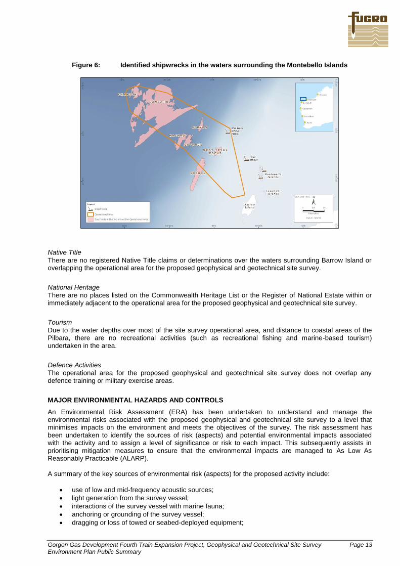
Gorgon Gas Development Fourth Train Expansion Project, Geophysical and Geotechnical Site Survey Page 13 Environment Plan Public Summary
Figure 6: Identified shipwrecks in the waters surrounding the Montebello Islands
Native Title
There are no registered Native Title claims or determinations over the waters surrounding Barrow Island or overlapping the operational area for the proposed geophysical and geotechnical site survey.
National Heritage There are no places listed on the Commonwealth Heritage List or the Register of National Estate within or immediately adjacent to the operational area for the proposed geophysical and geotechnical site survey.
Tourism Due to the water depths over most of the site survey operational area, and distance to coastal areas of the Pilbara, there are no recreational activities (such as recreational fishing and marine-based tourism) undertaken in the area.
Defence Activities The operational area for the proposed geophysical and geotechnical site survey does not overlap any defence training or military exercise areas.
MAJOR ENVIRONMENTAL HAZARDS AND CONTROLS
An Environmental Risk Assessment (ERA) has been undertaken to understand and manage the environmental risks associated with the proposed geophysical and geotechnical site survey to a level that minimises impacts on the environment and meets the objectives of the survey. The risk assessment has been undertaken to identify the sources of risk (aspects) and potential environmental impacts associated with the activity and to assign a level of significance or risk to each impact. This subsequently assists in prioritising mitigation measures to ensure that the environmental impacts are managed to As Low As Reasonably Practicable (ALARP). A summary of the key sources of environmental risk (aspects) for the proposed activity include:
use of low and mid-frequency acoustic sources;
light generation from the survey vessel;
interactions of the survey vessel with marine fauna;
anchoring or grounding of the survey vessel;
dragging or loss of towed or seabed-deployed equipment;
Gorgon Gas Development Fourth Train Expansion Project, Geophysical and Geotechnical Site Survey Page 14 Environment Plan Public Summary
drilling and coring of the seabed;
emissions to atmosphere from the survey vessel;
discharge of ballast water and survey vessel biological fouling;
routine discharge of wastewater and waste to the ocean from the survey vessel;
accidental discharge of hydrocarbons and chemicals to the ocean from the survey vessel;
vessel collisions resulting in fuel and oil spills, and/or damage to benthic habitats;
interactions with commercial fishing and shipping; and
operation of the survey vessel within, or in the vicinity of, protected and heritage areas. A summary of the potential environmental impacts associated with the above sources of environmental risk include:
disturbance to marine fauna including cetaceans, turtles, fish and benthic epifauna;
disturbance to the seabed and benthic habitats and communities;
localised reduction in water quality from drilling and coring activities;
reduced air quality from atmospheric emissions as a result of operation of machinery and use of internal combustion engines;
introduction of invasive marine species as a result of ballast water discharge and vessel biological fouling;
marine pollution from routine discharges including sewage water, bilge water and other solid wastes;
marine pollution from accidental discharges including hydrocarbon spills and hazardous materials;
disturbance to social and community values due to interactions with commercial fishing vessels and shipping; and
disturbance to heritage and conservation values. The environmental aspects of the geophysical and geotechnical site survey that have the potential to cause significant environmental effects have been determined through an evaluation of the proposed activity, the surrounding environment including specific sensitivities and values, and legislative requirements. These environmental aspects are:
accidental discharge of hazardous materials;
accidental fuel and oil spills from the survey vessel; and
vessel collisions, resulting in fuel and oil spills and/or damage to benthic habitats. Implemented control measures documented in Table 2 ensures that the environmental risks associated with these impacts are maintained at ALARP levels, while maintaining economic viability for the proposed activity. These control measures are taken into consideration in calculating the residual risk associated with the potential environmental impacts.
MANAGEMENT APPROACH
The design and execution of the proposed geophysical and geotechnical site survey will be conducted under the framework of the Fugro-TSM Environmental Policy and Vessel Management System. The geophysical/geotechnical survey programme will be supported by Fugro Marine Services Emergency Response Manual Vessel, and a project-specific HSE Plan, that has been compiled by Fugro Survey. Fugro will apply a tiered approach to optimising the environmental performance of the project and ensuring that Fugro’s environmental standards and performance objectives are achieved. The approach involves identification of local and regional environmental sensitivities, prioritisation of risks, determination of appropriate practices and procedures to reduce those risks, and clear designation of roles and responsibilities for implementation. A series of plans, procedures and work instructions will be used for the proposed geophysical and geotechnical site survey to ensure that appropriate management measures are applied as required to minimise the risk of environmental disturbance from operations. The plans, procedures and work instructions are documented within corporate systems/manuals developed by Fugro as well as documents written specifically for the site survey (e.g. project-specific HSE Plan). Many of the procedures apply to all vessels in the Fugro fleet, however the associated work instructions are generally vessel specific.
Gorgon Gas Development Fourth Train Expansion Project, Geophysical and Geotechnical Site Survey Page 15 Environment Plan Public Summary
Fugro is responsible for ensuring that the proposed geophysical and geotechnical site survey is managed in accordance with the Implementation Strategy described in the Environment Plan and the Fugro-TSM Vessel Management System. Given the control measures that will be implemented for all environmental aspects of the survey, the risk of significant adverse environmental effects from the proposed geophysical and geotechnical site survey has been assessed as low for all aspects, apart from discharge of hazardous materials, fuel and oil spills and vessel collisions, which have been assessed as medium. The implementation of specific marine fauna monitoring and encounter procedures will be used to minimise the potential for any adverse effects to whales. These procedures are consistent with applicable requirements of the Australian Commonwealth Government Guidelines: EPBC Act Policy Statement 2.1 – Interaction between offshore seismic exploration and whales (September 2008). A precautionary 300 m shutdown zone for whales will be applied for use of low and mid-frequency acoustic sources during the site survey—i.e. if a whale/s is sighted or enters within 300 m of the survey vessel or surface towed geophysical equipment, the acoustic source will be shut down completely. Specific vessel-whale interaction procedures will also be applied for non-acoustic source operations. Owing to their migratory habits, all five species of turtle that may occur in the operational area and surrounding waters have the potential to be present in open ocean habitats throughout the operational area, albeit in low densities. Whilst the shallow water areas of the operational area do include features that may be feeding areas for turtles (i.e. coral reef areas), the density of animals is likely to be low, and as such the probability of impacts on turtles is also low. It is unlikely that turtles would use this area for any significant period of time and survey activities are unlikely to significantly affect the population of any marine turtle species. The operational area is not located close to any locations important for seabird or shorebird breeding or feeding. The survey is unlikely to have any significant effects on benthic communities due to the water depths across most of the operational area, and the absence of any significant or sensitive benthic habitats or communities. Anchoring of the survey vessel will only occur in emergency circumstances, and the vessel is fitted with highly sophisticated position fixing equipment. Shallow water geotechnical operations during the site survey will involve a seabed blockdrive PCPT, gravity piston coring and box coring. Deep-water geotechnical operations during the will involve use of the drilling system aboard the Fugro Synergy. Drilling will be performed using standard straight flush rotary methods without a riser, and seawater or guar gum will be used as a drilling fluid (water-based mud - WBM). The seabed in the inshore and offshore components of the operational area will be subject to localised physical disturbance during PCPT, coring and drilling operations. The area of seabed to be disturbed at each site during seabed sampling and/or testing operations is very small and comprises of the borehole and the footprint of the cores/samples taken. It is expected that any impacts on the seabed as a result of the survey activities will be minor and have only a short-term effect. The geotechnical sampling and testing programme is of low intensity and affects only a very small area of seabed at each location. The geotechnical site survey will involve the discharge of a small amount of drill cuttings and mud to the marine environment. There is potential for drill cuttings to smother a small area of seabed and as such possibly generate anoxic conditions in the sediments over time. However, any smothering effects on the sparse benthic communities in the operational area would be highly localised and on a small scale, particularly given the borehole depths only range from 20–40 m and the borehole diameter is ~25 cm. As the seabed sediments and benthic communities in the operational area are uniform and widespread throughout the NWS, the consequences of changes to these communities in the vicinity of the drilling locations can be considered to be low. During the survey, the Fugro Synergy will be refuelled in port in Dampier. No at sea refuelling will take place during the survey. Hence, the probability of diesel fuel spills from transfer operations is zero. The risk assessment and mitigation/management measures described in the Environment Plan clearly demonstrate that the environmental impacts and risks of fuel and oil spills associated with the proposed geophysical and geotechnical site survey have been reduced to ALARP, and that these impacts and risks are of an acceptable level. This conclusion has been reached on the basis of a number of factors, including:
the low likelihood of a large diesel spill occurring in the first place;
the low probability of exposure of sensitive resources (e.g. green turtles and coral communities on the west coast of Barrow Island) to surface slicks or entrained oil;

Gorgon Gas Development Fourth Train Expansion Project, Geophysical and Geotechnical Site Survey Page 16 Environment Plan Public Summary
the very conservative thresholds applied in the risk assessment for surface slicks or entrained oil—i.e. there is a very low probability that surface slicks or entrained oil at these concentrations would cause significant environmental effects to any sensitive resources; and
the limited spatial and temporal extent of survey activities in the south-east corner of the operational area, close to shallow waters and shorelines, relative to the overall extent and duration of the activity (i.e. operations in shallow, inshore waters close to Barrow Island represent only a small proportion of overall survey activities).
CONSULTATION PLAN
Consultation with stakeholder groups concerning Fugro’s proposed geophysical and geotechnical site survey for the Gorgon Gas Development Fourth Train Expansion Project has taken place, primarily within the commercial fishing industry, during the preparation of the Environment Plan, and prior to the commencement of the survey. The following organisations have been contacted and informed of the proposed operations:
A Raptis and Sons
Austral Fisheries
Australian Fisheries Management Authority
Australian Hydrographic Service
Australian Maritime Safety Authority
Centre for Whale Research
Commonwealth Fisheries Association
Department of Broadband, Communications and the Digital Economy
Department of Sustainability, Environment, Water, Population and Communities
Geoscience Australia
MG Kailis
National Native Title Tribunal
Northern Fishing Companies Association
Recfishwest
Shark Bay Seafoods
Telstra
TunaWest
WA Department of Environment and Conservation
WA Department of Fisheries
WA Department of Mines and Petroleum
WA Department of Transport
WA Fishing Industry Council
WA Marine Parks and Reserves Authority
WestMore Seafoods Consultation with all of the stakeholders listed above, plus any others identified during the consultation process, will continue during and after the survey, if necessary.

Gorgon Gas Development Fourth Train Expansion Project, Geophysical and Geotechnical Site Survey Page 17 Environment Plan Public Summary
Table 2: Summary of environmental risks and management approach for key aspects of the proposed geophysical and geotechnical site survey
Impact category Potential impacts Control and mitigation measures Residual risk level
Disturbance to marine fauna
Cetaceans - behavioural reactions (avoidance, diving, increased dive times) Disturbance to marine turtles, fish communities, and seabirds
Adherence to EPBC Act Policy Statement 2.1: 300 m shut-down zone for acoustic sources
Application of vessel-whale interaction procedures for non-acoustic energy source operations
External lighting of survey vessel will be minimized to that required for navigation, vessel safety and safety of deck operations, except in the case of emergency
Operational area is located at least 7.3 km away from any beaches and adjacent shallow waters important for turtle nesting, hatching and breeding
Operational area is not located close to any locations important for seabird or shorebird breeding or feeding
Survey will not be operating over critical habitat for feeding, spawning, breeding or migrating fish populations
Low
Disturbance to benthic habitats
Small localised disturbance to epibiota in event of loss of equipment
Survey will be conducted in water depths of ~25-1,397 m away from any shallow water areas or significant/sensitive benthic habitats and communities
No anchoring of the survey vessel will take place during survey unless in an emergency
All reasonable efforts taken to retrieve lost equipment
Recording and reporting of all items lost overboard
Low
Introduction of invasive marine species
Introduction and establishment of invasive marine species with consequent impacts on benthic communities, fisheries etc.
Survey vessel required for the proposed activity will not discharge ballast water
Adherence the Australian Ballast Water Management Requirements, if necessary
The survey vessel has all the necessary AQIS clearances to operate unrestricted anywhere in Australian waters
Low
Marine pollution from routine discharges
Localised temporary decrease in ambient water quality from discharge of sewage, grey water, putrescible wastes and bilge water
All sewage and putrescible wastes will be handled and disposed of in accordance with MARPOL Annex IV
Discharge of sewage and putrescibles waste will be of short duration with high dispersion and biodegradability
Sewage and putrescible wastes macerated where possible prior to disposal
All sewage and putrescible waste treatment systems and holding tanks are to be fully operational prior to survey commencement
Relevant discharge requirements for treated and untreated sewage are adhered to (>3 nm from land for treated sewage; >12 nm from land for untreated sewage)
Low
Marine pollution from accidental discharges
Acute toxicity effects on marine fauna, such as marine turtles, fishes and seabirds, from accidental discharges of hazardous materials
Harmful Packaged Substances handled and disposed of in accordance with MARPOL Annex V
Waste Stream Management Plan in place detailing wastes generated and disposal requirements
No discharge of plastics or plastic products of any kind from survey vessel
All solid, liquid and hazardous wastes (other than sewage, grey water and putrescible
Medium
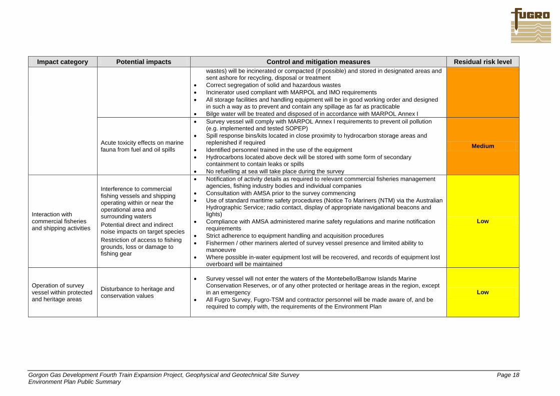
Gorgon Gas Development Fourth Train Expansion Project, Geophysical and Geotechnical Site Survey Page 18 Environment Plan Public Summary
Impact category Potential impacts Control and mitigation measures Residual risk level
wastes) will be incinerated or compacted (if possible) and stored in designated areas and sent ashore for recycling, disposal or treatment
Correct segregation of solid and hazardous wastes
Incinerator used compliant with MARPOL and IMO requirements
All storage facilities and handling equipment will be in good working order and designed in such a way as to prevent and contain any spillage as far as practicable
Bilge water will be treated and disposed of in accordance with MARPOL Annex I
Acute toxicity effects on marine fauna from fuel and oil spills
Survey vessel will comply with MARPOL Annex I requirements to prevent oil pollution (e.g. implemented and tested SOPEP)
Spill response bins/kits located in close proximity to hydrocarbon storage areas and replenished if required
Identified personnel trained in the use of the equipment
Hydrocarbons located above deck will be stored with some form of secondary containment to contain leaks or spills
No refuelling at sea will take place during the survey
Medium
Interaction with commercial fisheries and shipping activities
Interference to commercial fishing vessels and shipping operating within or near the operational area and surrounding waters
Potential direct and indirect noise impacts on target species
Restriction of access to fishing grounds, loss or damage to fishing gear
Notification of activity details as required to relevant commercial fisheries management agencies, fishing industry bodies and individual companies
Consultation with AMSA prior to the survey commencing
Use of standard maritime safety procedures (Notice To Mariners (NTM) via the Australian Hydrographic Service; radio contact, display of appropriate navigational beacons and lights)
Compliance with AMSA administered marine safety regulations and marine notification requirements
Strict adherence to equipment handling and acquisition procedures
Fishermen / other mariners alerted of survey vessel presence and limited ability to manoeuvre
Where possible in-water equipment lost will be recovered, and records of equipment lost overboard will be maintained
Low
Operation of survey vessel within protected and heritage areas
Disturbance to heritage and conservation values
Survey vessel will not enter the waters of the Montebello/Barrow Islands Marine Conservation Reserves, or of any other protected or heritage areas in the region, except in an emergency
All Fugro Survey, Fugro-TSM and contractor personnel will be made aware of, and be required to comply with, the requirements of the Environment Plan
Low
Gorgon Gas Development Fourth Train Expansion Project, Geophysical and Geotechnical Site Survey Page 19 Environment Plan Public Summary
FURTHER DETAILS
For further information about the proposed Fugro proposed geophysical and geotechnical site survey, Gorgon Gas Development Fourth Train Expansion Project, which will take place on the NWS offshore from the Pilbara coastline, please contact: Ian Bloys Executive Project Manager Fugro Survey Pty Ltd 24 Geddes Street Balcatta WA 6021 Phone: (08) 6477 4400 Fax: (08) 6477 4499 Email: [email protected]