Embed Size (px)
Citation preview

Geomorphic Effects of the Retreat of Jamapa Glacier, Pico de Orizaba Volcano (Mexico)Author(s): D. Palacios and L. Vazquez-SelemSource: Geografiska Annaler. Series A, Physical Geography, Vol. 78, No. 1 (1996), pp. 19-34Published by: Blackwell Publishing on behalf of the Swedish Society for Anthropology andGeographyStable URL: http://www.jstor.org/stable/521132Accessed: 12/01/2010 16:42
Your use of the JSTOR archive indicates your acceptance of JSTOR's Terms and Conditions of Use, available athttp://www.jstor.org/page/info/about/policies/terms.jsp. JSTOR's Terms and Conditions of Use provides, in part, that unlessyou have obtained prior permission, you may not download an entire issue of a journal or multiple copies of articles, and youmay use content in the JSTOR archive only for your personal, non-commercial use.
Please contact the publisher regarding any further use of this work. Publisher contact information may be obtained athttp://www.jstor.org/action/showPublisher?publisherCode=black.
Each copy of any part of a JSTOR transmission must contain the same copyright notice that appears on the screen or printedpage of such transmission.
JSTOR is a not-for-profit service that helps scholars, researchers, and students discover, use, and build upon a wide range ofcontent in a trusted digital archive. We use information technology and tools to increase productivity and facilitate new formsof scholarship. For more information about JSTOR, please contact [email protected].
Swedish Society for Anthropology and Geography and Blackwell Publishing are collaborating with JSTOR todigitize, preserve and extend access to Geografiska Annaler. Series A, Physical Geography.
http://www.jstor.org
GEOMORPHIC EFFECTS OF THE RETREAT OF JAMAPA GLACIER, PICO DE ORIZABA VOLCANO
(MEXICO)
BY D. PALACIOS and L. VAZQUEZ-SELEM 2
Department of A.G.R. and Physical Geography, Complutense University, Madrid, Spain 2 Institute of Geography, National Autonomous University of Mexico,
Ciudad Universitaria, Mexico, D.E, Mexico
Palacios, D. and Vdzquez-Selem, L., 1996: Geomorphic ef- fects of the retreat of Jamapa Glacier, Pico de Orizaba Vol- cano (Mexico). Geogr. Ann. 78 A (1): 19-34. © Scandinavian University Press on licence from the Swedish Society for Anthropology and Geography.
ABSTRACT. Pico de Orizaba (5,700 m), on the eastern edge of the Transmexican Volcanic Belt, is an active volcano whose most recent eruption took place in 1687. Its summit is now covered by an ice cap from which several glaciers form. As on other mountains of central Mexico, the glaciers of Pico de Orizaba have retreated considerably during the past century and, in particular, during the last decades. This study focuses on the recent evolution of Jamapa Glacier, on the northern part of the mountain. It analyzes the geomor- phologic processes in relation to the rapid retreat of the gla- cier snout and the intense periglacial activity on the valley sidewalls. The paper presents data on the thermic regime of ice cover deposits and their contrast with that of the glacier. At the end, it summarizes a model of the geomorphic evolu- tion of the area below a retreating glacier.
Introduction Pico de Orizaba volcano, also called Citlaltepetl, is on the eastern part of the Transmexican Volcanic Belt, at 19° 01' N and 97° 16' W, less than 100 kilometers west of the coast of the Gulf of Mexico (Fig. 1). Its altitude has never been accurately de- termined and current references range from 5,675 to 5,700 m. Pico de Orizaba is one of the three Mexican stratovolcanoes that still has glaciers. The other two volcanoes are Popocatepetl (5,450 m) and Iztaccihuatl (5,286 m). Pico de Orizaba and Popocatepetl have had recent and also, pre- sent day volcanic activity, but it was mainly during the Recent Pleistocene and the Holocene that vol- canic and glacier activity interacted. This has gen- erated distinctive types of processes and land- forms. During the last century the retreat of the glaciers became evident, and in the valleys and ba-
sins that were exposed after the ice withdrew, a peculiar type of erosive process took place that was conditioned mainly by the kind of volcanic rock found there.
Robin and Cantagrel (1982) defined the overall volcanic history of Pico de Orizaba. Robin, Can- tagrel and Vicent (1983) Hoskuldsson and Robin (1993), Siebe et al. (1991, 1993) and Carrasco- Nufiez et al. (1993) studied various eruptive events of the Late Pleistocene and Holocene in detail. Heine (1975a, 1988) identified several moraine complexes of the Late Pleistocene and Holocene on Pico de Orizaba and correlated them to those of other mountains of central Mexico. He also re- ported the presence of permafrost in the proximity of Jamapa Glacier (Heine 1975b). Lorenzo (1964) surveyed and mapped the glaciers of the volcano and made some observations on the youngest mo- raines.
This paper analyzes the geomorphic processes developed during past decades in the most impor- tant glacier valley of Pico de Orizaba: the Jamapa Valley. These processes are due to the rapid retreat of the glacier and to the characteristics of the vol- canic materials. Local bibliography and aerial photographs from different periods were used to study the volcano-glacial evolution of Pico de Orizaba. Fieldwork carried out in February 1994 produced an accurate geomorphologic map and data on the sedimentary and thermic characteris- tics of the retreating glacier and derived deposits. On this basis a hypothesis was developed on the re- cent geomorphic evolution and the types of pro- cesses operating today.
Volcano-glacial context of the study area Pico de Orizaba is on the eastern edge of the Trans-
Geografiska Annaler * 78 A (1996) · 1 19
D. PALACIOS AND L. VAZQUEZ-SELEM
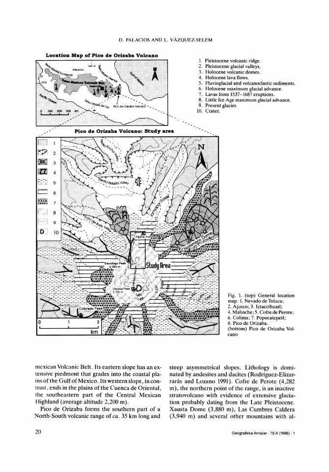
Location Map of Pico de Orizaba Volcl
Pico de Orizaba Volcano: Study area
I II =- km -
'SK-a StRdynrea ' > 5.080m Sj u re
~'y:-- ' ~ "~' t t ' - ------
i Wi '*t:, .'
i'.'-t -"/\-A - - - - - -
Orizaba Peak Va *
: ~
U M lNtB
mexican Volcanic Belt. Its eastern slope has an ex- tensive piedmont that grades into the coastal pla- ins of the Gulf of Mexico. Its western slope, in con- trast, ends in the plains of the Cuenca de Oriental, the southeastern part of the Central Mexican
Highland (average altitude 2,200 m). Pico de Orizaba forms the southern part of a
North-South volcanic range of ca. 35 km long and
1. Pleistocene volcanic ridge. 2. Pleistocene glacial valleys. 3. Holocene volcanic domes. 4. Holocene lava flows. 5. Fluvioglacial and volcanoclastic sediments. 6. Holocene maximum glacial advance. 7. Lavas from 1537-1687 eruptions. 8. Little Ice Age maximum glacial advance. 9. Present glacier.
10. Crater.
I} il i ii!i
::::- :: map. 1. Nevado:deToluca;
. . . . . . . . . . . . . .. . -o-t.
2. Ajusco 3. Iztaccihuat; -- . -Cofre de Perote
-..... 6. Colima; 7. Popocatepetl. 8. Pico de Orizaba.
ima (bottom) Pic. o de Orizaba Vl-
6. Colima; 7. Pocanot : cano
steep asymmetrical slopes. Lithology is domi- nated by andesites and dacites (Rodriguez-Elizar- raras and Lozano 1991). Cofre de Perote (4,282 m), the northern point of the range, is an inactive stratovolcano with evidence of extensive glacia- tion probably dating from the Late Pleistocene. Xausta Dome (3,880 m), Las Cumbres Caldera
(3,940 m) and several other mountains with al-
Geografiska Annaler * 78 A (1996) * 1 20
GEOMORPHIC EFFECTS OF THE RETREAT OF JAMAPA GLACIER, (MEXICO)
titudes over 3,800 m located between Cofre de Per- ote and Pico de Orizaba have similar morphologic evidence of glaciation.
The eruptive history of Pico de Orizaba has been divided in three stages (Robin and Cantagrel 1982). During the first one, which lasted 1 million years, the entire base of the stratovolcano de- veloped. During the second stage (100,000 to ca. 33,000 yr BP) the formation of a large caldera was followed by large andesitic and dacitic domes and numerous blocks and ash flows (Robin and Can- tagrel 1982; Hoskuldsson 1990; Hoskuldsson and Robin 1993). The third phase began 19,000 yr BP with the formation of the new cone, which covers most of the wall of the caldera and the inner domes. It consisted of several alternated phases of andesitic lava flows and pyroclastic eruptions (Hoskuldsson and Robin 1993). An episode of de- bris avalanche that was transformed into lahar, seemingly due to the presence of glacier ice took place at ca. 13,000 yr BP on the eastern slope (Car- rasco-Nufiez et al. 1993). A series of pyroclastic flows were channeled through a glacier cirque and formed a wide fan on the western slope between 4,660 and 4,040 yr BP (Siebe et al. 1993). The last eruptive phase (700 A.D. to 1687 A.D.) included seven separately identifiable eruptions. They were effusive, with the exception of one plinian event (Mooser et al. 1958; Simkin et al. 1981; Robin and Cantagrel 1982; Cantagrel et al. 1984; and Hos- kuldsson and Robin 1993). The historic lavas were emitted from the upper crater and flowed down in all directions. They advanced through the ravines and glacier valleys and in some cases filled them completely. In 1537 the lava flowed on the north and northeastern sides, while in 1545, 1566 and 1613 it flowed on the south side. The activity con- tinued until 1687 with weak explosive eruptions. Since then, there has only been mixed fumarole activity (Hoskuldsson and Robin 1993).
According to Heine (1975a, 1983, 1988) the maximum advance of the glaciers prior to the ad- vent of Holocene conditions took place between 10,000 and 8,500 yr BP on Pico de Orizaba and in general in Mexico. He also identified signs of only two Neoglacial advances. The first one is evi- denced by morainic loops around the base of the terminal cone at 4,000-4,400 m, which were depo- sited prior to 1730 + 85 yr BP and probably be- tween 3,000 and 2,000 yr BP (Heine 1983, 1988). The second Neoglacial advance is from the L.I.A. (Little Ice Age), which reached its limit of influ- ence in Mexico by the middle of the 19th century
and formed a series of moraines between 4,400 and 4,800 m on Pico de Orizaba (Heine 1975a, 1983, 1988). In both Neoglacial episodes, the gla- ciers extended mainly on the northern and west- ern slopes.
It is interesting to point out that the end of the last eruptive episode coincided with the beginning of the L.I.A., so the eruptions would have de- stroyed the existing glaciers. Subsequently the gla- ciers of the L.I.A. formed on top of the new lava.
Geomorphology of the north face of Pico de Orizaba A major feature of the northern slope of Pico de Orizaba is Sarc6fago Peak (5,080 m), a remnant of an older cone which collapsed to the north (Hos- kuldsson and Robin 1993) (Figs 2 and 3). A large amphitheater on the west side of the peak has been interpreted as the result of a more recent col- lapse (Hoskuldsson 1990; Hoskuldsson et al. 1990) and also as a glacial cirque which channeled a series of block and ash flows between 4,600 and 4,040 yr BP (Siebe et al. 1993). The eastern wall of Sarcofago exposes many andesitic lava flows inter- spersed with pyroclastic flow and fall deposits. It limits the north face of the modern terminal cone. A lava flow of large dimensions descends from the crater and covers nearly the entire north face of the cone. It is the youngest formation of the north- ern slope and has been related to the eruption of 1537 A.D. and called Jamapa Lava Flow by Hos- kuldsson and Robin (1993). The lava moved from the crater and formed well developed levees. Its upper portion is concealed by an ice cap, whose longest snout is called Jamapa Glacier (Lorenzo 1964). The glacier now lies atop part of the lava, but during the L.I.A. it covered it completely (Figs 2 and 3).
The entire surface of the lava flow shows evi- dence of glacial abrasion. Above 4,500 m there are no remains of glacial sediments, but beyond this elevation the lava lies beneath various morainic formations that were earlier identified as belong- ing to the L.I.A. (Heine 1975a, 1983, 1988). Dur- ing the main advance the morainic material ac- cumulated along all of the frontal portion of Jamapa Glacier, except on the western margin where the glacier was confined by the wall of Sar- c6fago. Remains of the corresponding lateral mo- raine appear at an altitude of 4,737 m on the east- ern margin of the former glacier tongue. The fron- tal moraine is better preserved. Its inner area is
Geografiska Annaler - 78 A (1996) · 1 21

D. PALACIOS AND L. VAZQUEZ-SELEM
BBRBiiS~-iiiiiiiiii B jE R ji..SR < :i.~ir: O ........'....
t) 'f'~
4
0iri:r 1 C 0 2 003C 4C mi-i:.iirXitir' 10
.Src-fao Peak b ---t.- Sff s~~~~~~~~ -'- ___3
..2. Volcanoclastic and glacial sediment
complex area.
4. Glacially smoothed surfaces on layers of lava flows.
0 ; ~ ~ ~ ~ ~ ~ ~ ~ ~ ~~~- 5. 1537-1687 lava flows. 7
Oriizaba Peak8. Subglacial moraine, affected by gullies.
10. Outwash deposits. 11. Nivation holl ow
12. Rockfall talus covering glacier ice.
13. Initial rock glaciers. 14. Stream incisions.
16. Present glacier. Fig. 2 Geomorphoogic map of Jamapa area (North face of Pico de Orizaba volcano).
".iii~~:-- :-.-I---:-.--:--~... 7.O ; 7 X <of lava-flows ~~;r z r--l ............ 7. L I A moraine.ridges
,m ii,iiltii~iiiiiii alc om le are a.
...--.-. i. i -..... .. -.
Fig. 2. Geomorphologic map L.I.A.mor ain Jamapa a ( co o O b.
concave and includes a small terminal basin now opened by gully incision. The crest is well defined and its lowest elevation is at 4,395 m. This point marks the lowest level to which the glaciers on Pico de Orizaba advanced during the L.I.A. The outer portion of the morainic formation consists of
a large ramp that reaches down to 4,200 m and was created by glacial pushing and the additional acti- on of proglacial waters. Subsequently, intense al- pine debris flow processes developed on top of the ramp. Following the debris flow stage, a gully inci- sion process began that continues today.
Geografiska Annaler * 78 A (1996) * 1 22

GEOMORPHIC EFFECTS OF THE RETREAT OF JAMAPA GLACIER, (MEXICO)
Pico de Orizaba
Fig. 3. Block-diagram of upper Jamapa valley (North face of Pico de Orizaba volcano).
Almost parallel to the aforementioned morainic
ridge is a second one with similar characteristics, but developed only in the central part (Figs 2 and 3). It indicates that the glacier front readvanced to an altitude of 4,460 m. A third ridge, smaller and located at higher elevation, is confined by the western levee of the large andesitic lava flow of 1537 and a prominent step formed on earlier lava flows. It suggests a third readvance of the glacier tongue that reached 4,485 m. These morainic ridges are composed of heterometric materials ranging from abundant great blocks (1.5 m in dia- meter) to fine particles, primarily ash. The central lava flow contributed little load to the glacier. Ac- cording to a rough estimate, about two thirds of the fragments in the central part of the lowest ridge came from the walls of Sarc6fago. Once the ice recedes from the base of the wall, a lot of mate- rial generated by erosion accumulates on the large taluses and traps glacial ice in their interior as dis- cussed below (Heine 1975b).
Partially covered by this lava flow, is another flow located to the east, with similar lithologic and
morphologic characteristics formed during the same eruption (Hoskuldsson and Robin 1993). It also has well developed levees and a gently sloping central surface that channeled the ice cap, creating
a large glacier tongue during its farthest advance in the L.I.A. A large frontal morainic ridge is also visible here and ends in a wide outwash. The front of the ice cap is now found on the upper part of the lava flow (Fig. 2 and 3). In contrast to the north side, the retreat of the glacier has left a vast, thick layer of subglacial moraine on the lava flow. The surface of this layer has an irregular pattern of de- formations and creates a series of small crests oriented in the direction of the flow. The deposits are heterometric, although there is a lot of fine ma- terial, mainly in the form of ash. Their origin could be linked to a pyroclastic layer now covered by the ice cap in higher slopes. In 1975 the interior of this moraine was frozen (Heine 1975b).
Between the levees of the two recent lava flows described above, there is a very noticeable nival hollow (Fig. 2). The floor of the hollow is strewn with blocks that have fallen from the walls of the levees and from volcanic levels under the lava flows, thus forming a protalus rampart.
The ramp that formed below the frontal morai- ne during the maximum glacier advances in the L.I.A., entered the floor of Jamapa Pleistocene glacial valley. A glacier from the first Neoglacial advance (3,000-2,000 yr BP) had covered the upper part of the valley (Heine 1975a, 1983, 1988), but its moraines can only be partially traced. The valley has a very clear U-shaped morphology and its floor is covered with recent volcanic material. On the left side, close to the alpine hut (Fig. 2), a lateral moraine morphology is displayed but is now covered by pumitic fall deposits. The pumice extends over all the areas not affected by the ero- sive processes of the L.I.A.
A series of L.I.A. deposits consisting of a mas- sive main moraine (ca. 4300 m) and three to four smaller recessional positions (between 4430 and 4540) was described in Iztaccihuatl (Whitel962). They are very similar to those of Pico de Orizaba both in morphology and altitude. The L.I.A. re- cessional moraines of Iztaccihuatl were interpre- ted by Heine (1975a) as a result of short periods of increased precipitation between ca. 1850 and 1950.
Recent retreat of Jamapa and other Orizaba glaciers The glaciers on Pico de Orizaba have steadily re- treated during this century (Fig. 4). Heine consid- ers that they reached their maximum L.I.A. ad- vance in 1850. Jamapa Valley moraine of the main
Geografiska Annaler * 78 A (1996) * 1 23

1. L.I.A. maximum advance (Heine 1988; and personal photo-interpretation and fieldwork).
2. The glaciers in 1945 (aerial photo; World Data Center A. at Boulder, CO. USA, and other anonymous photographs).
3. The glaciers in 1958 (Lorenzo 1964).
4. The glaciers in 1971/75 (aerial photo, CETENAL, 11-1971 and 08-1975; and Heine 1975b).
5. The glaciers in 1988 (aerial oblique photo, Zambrano 1988).
6. The glaciers in 1994 (per- sonal observations).
7. Minimum altitude. 8. Year of the data.
Fig. 4. Recent evolution of Pico de Orizaba glaciers (names of glaciers after Lorenzo 1964).
Geografiska Annaler · 78 A (1996) · 1
D. PALACIOS AND L. VAZQUEZ-SELEM
24
GEOMORPHIC EFFECTS OF THE RETREAT OF JAMAPA GLACIER, (MEXICO)
L.I.A. advance is found at 4,395 m and recessional positions at 4,460 and 4,485 m.
The extent of the glacier area in 1945 was deter- mined through the use of a collection of aerial photographs (World Data Center A, Boulder, CO, USA), supplemented with other photos from un- known sources found in different archives and col- lections. By 1945, the glacier had been reduced to an ice cap whose center lay on the northern side of the new upper cone of Pico de Orizaba. A number of tongues extended from the upper cap, the longest of which is Jamapa Glacier, with a length of 6,000 m from the summit (names of glaciers ac- cording to Lorenzo 1964). The end of the tongue was divided into three small tongues separated by the levees of the recent andesitic lava flows de- scribed in the foregoing section. The western ton- gue reached an elevation of 4,590 m and was pro- tected by the wall of Sarc6fago Peak. Another ton- gue located to the east of Jamapa Glacier moved down over the other recent lava flow to an eleva- tion of ca. 4,725 m. It is called Chichimeco Gla- cier. On the eastern side of the cone Oriental Gla- cier (Eastern Glacier) tongue reached an altitude of 4,900 m and was separated from the ice cap by a narrow corridor. A complex of several glacier tongues on the west side of the cone, was channel- led between rocky spurs and even managed to clear steep cliffs. The northwestern tongue, Toro Glacier, descended to nearly 4,600 m. Farther south was a great cascade of seracs that ended at 4,700 m. Two large tongues appeared to the south- west and, despite less favorable aspect conditions, moved down the gentle slope of the recent lavas to 4,900 m.
In 1958 Jose L. Lorenzo headed a topographic survey of these glaciers (Lorenzo 1964). The changes between 1945 and 1958 are of little signifi- cance. Jamapa and Chichimeco tongues had barely receded, although Jamapa was narrower. The glacier which had once covered the youngest lava flows of the north side, only covered its cen- tral portion and western edge. Two small tongues at the front were separated by the western levee of the youngest lava flow. The tongue farthest east had advanced to 4,650 m while the western one reached 4,640 m. A space had begun to appear be- tween the western border of the glacier and the wall of Sarc6fago Peak, and a debris talus was forming there. Chichimeco Glacier was also be- coming narrower and had retreated to 4,750 m. The front of Oriental Glacier had retreated to 5,070 m. The major differences are more apparent
on the western glaciers. The cascades had disap- peared and the front of the glaciers were located at the edge of great cliffs. The big blocks of ice that piled up at the base were no longer able to regener- ate the glacier. Toro Glacier only reached 4,970 m. The southwestern glaciers had retreated (4,980 m) creating a sharp step in the slope in this sector.
The following information is from 1971 and 1975 aerial photographs (CETENAL, XI 71 and VIII 75) and fieldwork conducted during these years by Heine (1975b) (Fig. 4). The observed changes are not very significant, and they probably illustrate the general tendency of other Mexican glaciers to reach a positive balance at the beginning of the 1970's (White 1981). Jamapa Glacier retreated only slightly, and the tongue that was located in the middle of the lava flow extended down to 4,655 m. A much more conspicuous space appeared be- tween the glacier and the wall of Sarc6fago peak, where a great debris talus was forming with glacier ice in its interior (Heine 1975b). The Chichimeco tongue was severely reduced, due in part to the gentle slope of the underlying lava. Its front re- treated to 4,930 m. A subglacial moraine appeared that was frozen inside (Heine 1975b). Neither Oriental Glacier nor the northwestern glaciers re- gistered significant changes since 1958. The south- western glaciers, however, had almost completely disappeared.
The next reference is a series of detailed oblique aerial photographs taken in 1988 (Zambrano 1988). Jamapa Glacier had retreated only slightly (4,660 m), while Chichimeco Glacier had disap- peared leaving a subglacial moraine. The north- western and western glaciers had not retreated, but their steep fronts had disappeared. The more than 60 m high cliff formed at the snout had been reduced to a gentle ramp of ice with a front edge that is only 2 to 5 m high. The southwestern gla- ciers continued to disappear, making it difficult to differentiate between different tongues.
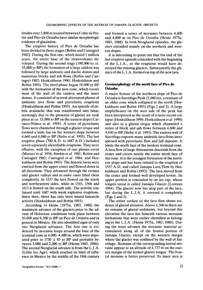
During February 1994, the authors conducted fieldwork at the volcano to determine the exten- sion of Jamapa Glacier with the aid of precision al- timeters. Conditions were favorable because there was virtually no snow. According to local climbers, a rocky threshold appeared in 1989 between the ice cap and Jamapa tongue. By 1994 the tongue had been reduced to two patches. The upper edge of the western patch is at 5,013 m (rocky threshold) and splits into two small tongues below the highest visible point of the levee (4,760 m): one tongue is between the levee and the wall of
Geografiska Annaler · 78 A (1996) * 1 25

D. PALACIOS AND L. VAZQUEZ-SELEM
Sarcofago Peak and reaches a minimum altitude of 4,718 m; the other one, to the east, ends at 4,745 m. The other patch is about 50 meters to the east, between 4,965 m and 4,735 m. Chichimeco Gla- cier has completely disappeared, so the ice cap on Pico de Orizaba has no tongues on its eastern and northern slopes. The ice cap extends to 5,037 m on the north side. The Oriental Glacier still exists al- though it is quite small. Its head is still on the edge of the crater but its minimum altitude is 5,100 m. The northwestern glaciers show less differences in their extension. The thickness of ice is probably, at most, a few meters thick and apparently has lost its capacity to flow.
In conclusion, the glaciers of Pico de Orizaba have undergone marked transformations in the last decades. At the beginning of the 20th century, they formed a glacial dome with many tongues that extended in all directions, except to the south. Gradually, the tongues disappeared until the dome was transformed into a simple ice cap with no tongues in the early nineties. Some of these changes were no doubt influenced by critical climatic changes, but topography also controls the pace of the retreating glaciers. For example, a sud- den retreat may occur when the glacier moves over a rocky escarpment and cannot regenerate any- more at the base of the latter. This happened to the western glaciers and to the Oriental glacier be- tween 1945 and 1958. The opposite might also ex- plain a sudden retreat. When the slope is gentle the glacier does not retreat much over a given time, but its thickness does diminish. When loss is substantial, the glacier retreats very quickly. This was the case of the southwestern glaciers and Chichimeco Glacier between 1975 and 1988. The same process is operating, but in an earlier phase, on the northwestern and western glaciers, which are apparently moving much slower but still have their tongues.
Jamapa Glacier has retreated very little in the last decades in comparison with the rest. Never- theless, the thickness of Jamapa Glacier has been greatly reduced. The rocky threshold that now separates the tongue from the ice cap has cut off the lower part of the glacier from its source. The two patches described earlier are now made up of stagnant ice, which will most likely disappear in 5 tolO years.
Geomorphology and geomorphic processes in the recent deglaciated area The snout of Jamapa Glacier has retreated from 4,590 m in the 1940's to 5,037 m in February 1994, and has left two residual ice patches between these elevations. As a result, approximately 0.5 sq km of glaciated surface is now exposed (Figs 2, 3, 4 and 5).
Almost all this deglaciated surface corresponds to the andesitic lava flows of 1537. The levees of the lava flows show signs of intense glacial abra- sion. As a result, the inner sides of the levees are smooth. The ice caused no quarrying effect, and only after it had retreated did a network of decom- pression fractures appear that destroyed the smoothness and formed sheeting structures that ran parallel to the surface. The outer sides of the levees have vertical slopes, which intersect the base of the lava flow exposing a layer of autobrec- ciated material. This allowed intense undermining of the edges of the lava flow during and after the peak glacial period. When the ice retreated, gravi- tational processes set in. At present the edges of the lava flow are covered by a strip of gravity de- posits composed of great blocks (between 1 and 5 m in diameter) that fall from the massive part of the lava flow as the base collapses.
Once the ice retreated, the surface of the central part showed a succession of thresholds and basins that largely correspond to original features of the lava flow , modified in detail by the glacier. The thresholds have a small base that measures no more than 30 m in length with a relative height of 15 to 20 m. The summit is sharp and the slopes are steep (60°-75° avg.). The thresholds form a dense labyrinth of pinnacles among small basins. The sur- face of the thresholds is scarred by abrasion. Some- times they form roches moutonnees or whale- backs. The numerous fractures on the pinnacles are associated with the decompression process that begins as the ice retreats and forms sheeting structures parallel to the glacial surface. The ba- sins are not filled with till sediment, since is very little of this material available, but there are some large blocks present that have recently fallen from the thresholds. Since the rock is permeable, stream action is very limited.
There is a small basin between the lava flow and the eastern escarpment of Sarc6fago Peak (Figs 2 and 3). The escarpment exposes a thick series of al- ternating lava flows and pyroclastic deposits. A 50 m thick dacitic lava flow appears at the base of the wall and has been severely scoured by glacial abra-
Geografiska Annaler 78 A (1996) * 1 26
GEOMORPHIC EFFECTS OF THE RETREAT OF JAMAPA GLACIER, (MEXICO)
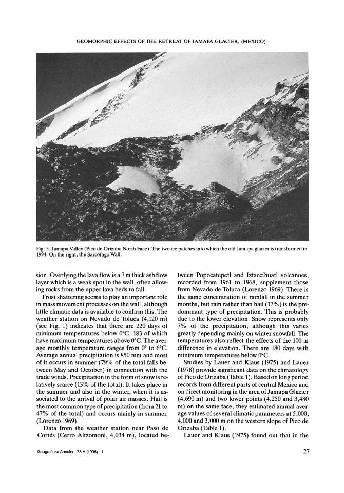
Fig. 5. Jamapa Valley (Pico de Orizaba North Face). The two ice patches into which the old Jamapa glacier is transformed in 1994. On the right, the Sarc6fago Wall.
sion. Overlying the lava flow is a 7 m thick ash flow layer which is a weak spot in the wall, often allow- ing rocks from the upper lava beds to fall.
Frost shattering seems to play an important role in mass movement processes on the wall, although little climatic data is available to confirm this. The weather station on Nevado de Toluca (4,120 m) (see Fig. 1) indicates that there are 220 days of minimum temperatures below 0°C, 183 of which have maximum temperatures above 0°C. The aver- age monthly temperature ranges from 0° to 6°C. Average annual precipitation is 850 mm and most of it occurs in summer (79% of the total falls be- tween May and October) in connection with the trade winds. Precipitation in the form of snow is re- latively scarce (13% of the total). It takes place in the summer and also in the winter, when it is as- sociated to the arrival of polar air masses. Hail is the most common type of precipitation (from 21 to 47% of the total) and occurs mainly in summer. (Lorenzo 1969)
Data from the weather station near Paso de Cortes (Cerro Altzomoni, 4,034 m), located be-
tween Popocatepetl and Iztaccihuatl volcanoes, recorded from 1961 to 1968, supplement those from Nevado de Toluca (Lorenzo 1969). There is the same concentration of rainfall in the summer months, but rain rather than hail (17%) is the pre- dominant type of precipitation. This is probably due to the lower elevation. Snow represents only 7% of the precipitation, although this varies greatly depending mainly on winter snowfall. The temperatures also reflect the effects of the 100 m difference in elevation. There are 180 days with minimum temperatures below 0°C.
Studies by Lauer and Klaus (1975) and Lauer (1978) provide significant data on the climatology of Pico de Orizaba (Table 1). Based on long period records from different parts of central Mexico and on direct monitoring in the area of Jamapa Glacier (4,690 m) and two lower points (4,250 and 3,480 m) on the same face, they estimated annual aver- age values of several climatic parameters at 5,000, 4,000 and 3,000 m on the western slope of Pico de Orizaba (Table 1).
Lauer and Klaus (1975) found out that in the
Geografiska Annaler · 78 A (1996) 1 27
D. PALACIOS AND L. VAZQUEZ-SELEM
N A 0 50 100 150m A A . -.
-:-::t 't-'-:-\ -- L,,, t1114 745 01 ' : : i:i: ? i:: i::: :::!,- ::!:i:i:i:i?i:i:i:i:: : :1 *, _ , * F :.............. ::: : .......... . . . . %::~ii~
!;¥:-Z:;'". .- " .......... : :- :--....... -- ! !::,:::::::::::.-------------- -::::::--:-:::-: :::::::::· ............ - ---.- ......- ...." -... ......... :~~~~~i : :: r..tg': . .. iii! .......!!!i!!'::::i!i!ii:;:;;i;? :; ...-.- ....__ * * . E :?;.-.-:-' :-:: : :-;- -[':j_| .,............................
- - :-: r.<. . ,. ;^ xz< Q ~~~~~~~~~~~~~~~~~~~~L -------I . ::::::::: ........::::::. . '
^
1 234..... 78911.. . ................
. ;'' '.. ' '' ' ' W w ............ * ' * * ' Us ' ' ' 1w
-... -.- .- .-.- *.........I· * _ ------ts ZE-
SS_***b**1-·- -·--- ··---- - - -- { J | t\t _--_-_-~-P______
1 2 3 4 5 6 7 ~ ~~~8 9 10 1 1 12 13 14
1994 4,745 I-, 15 16 17 18
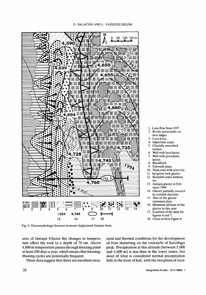
Fig. 6. Geomorphologic features in recent deglaciated Jamapa Area.
area of Jamapa Glacier the changes in tempera- ture affect the rock to a depth of 70 cm. Above 4,000 m temperature passes through freezing point at least 200 days a year, which means that freezing- thawing cycles are potentially frequent.
These data suggest that there are excellent struc-
1. Lava flow from 1537. 2. Roche moutonnee on
lava ridges. 3. Lava levee. 4. Important scarp. 5. Glacially smoothed
surface. 6. Wall with lava layers. 7. Wall with pyroclastic
layers. 8. Blockfield. 9. Outwash plain.
10. Talus cone with cover ice. 11. Incipient rock glacier. 12. Rockfall cones without
ice. 13. Jamapa glacier in Feb-
ruary 1994. 14. Glacier partially covered
by rockfall deposits. 15. Year of the glacier
extension data. 16. Minimum altitude of the
glacier in this year. 17. Location of the data for
figures 6 and 7. 18. Cross section Figure 8.
tural and thermal conditions for the development of frost shattering on the rockwalls of Sarc6fago peak. Precipitation at this altitude (between 5,000 and 4,600 m) is less than in the lower zones, but most of what is considered normal precipitation falls in the form of hail, with the exception of occa-
Geografiska Annaler * 78 A (1996) 1 28

GEOMORPHIC EFFECTS OF THE RETREAT OF JAMAPA GLACIER, (MEXICO)
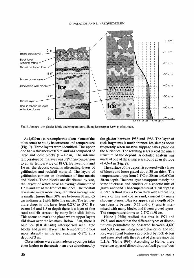
m
Fig. 7. Jamapa rock glacier fab- ric and temperatures. Slump ice scarp at 4,639 m of altitude.
K | | - -- --| -
- ::: i
I
:- :----'- -- -- -- I
-3m .__.. 50 4 - + - -- -
I I I F,20 ::.
!1 : i'' '- ---Loose block layer
" "1':--: :-----' - Block layer :-:: - , -: with fine matrix
"-..>.. i - - < Gravel and sand layer
iS?£*~~·¥' >s~ 5*>^ - < Old gelifluxion lobes
'**4f" -: ;f:;:i: '' Fine sand and silt layer with slide planes
-1 -2° -30 -4°0 5° C \ Frozen gravel layer
Glacier Ice with blocks
sional heavy snowfalls. Thanks to the step-like shape of the wall, snow patches form on the ledges. When they melt, they provide the base of the wall with a year round supply of water. The se- verely fractured structure of the lava is highly permeable, but water remains stagnant at the con- tact with less permeable strata of pyroclastic de- posits. The snow patches are also a source of fre- quent snow avalanches that occur after heavy snowfalls and often carry large amounts of debris. These conditions have fostered the rapid develop- ment of talus slopes that cover the entire base of the wall and grow as the glacier retreats. They form so fast that when the glacial ice can no longer flow, they trap and incorporate the ice within the de- posit.
Fabric and thermal characteristics of talus on the upper Jamapa Valley The talus is formed by a sequence of coalescent talus cones (Fig. 6). When the glacier moved along the base of the wall, rock and snow slides contribu- ted to the major part of the rock load of the glacier (see section on the L.I.A. moraines above).
Today, it is possible to observe the transition from the most developed talus cones (north), to the incipient talus cones near the glacier (south). The former are situated in the area abandoned by the glacier between 1945 and 1958. Flow oriented in the direction of the valley slope deformed the base of the talus cones evolving into incipient rock glaciers. Sharply pointed concentric ridges of ca. 1 m high are a result of these flow structures.
Table 1 Climatic data of Pico de Orizaba (from Lauer and Klaus 1975 and Lauer 1978)
Altitudes in meters 5,000 4,000 3,000 2,500
Mean annual temperature in °C 0 5 10 15 Mean January temperature in °C -1 3 7 11 Mean July temperature in °C 1 7 13 18 Mean annual temperature variation -2 -4 -5.5 Average number of days with minimum
temperature below freezing point 360 200 120 50 Average number of days with maximum
temperature below freezing point 160 45 0 0
Total precipitacion in mm 800 900 1,200 1,000 _~~~~~~~~~~~~~~~~~~iiiiii . i . i
Geografiska Annaler · 78 A (1996) I 1 29
D. PALACIOS AND L. VAZQUEZ-SELEM
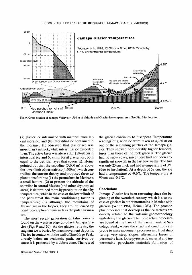
- - - -I- - 4. - --- - -
N-d-,
0 m Loose block layer
Block layer with fine matrix
Gravel and sand layer
-2 m
Frozen gravel layer
Glacier Ice with blocks--
-4 m Gravel layer
Fine sand and silt layer with slide planes
-6 m
0 cm
-10cm
-20 cm
-30 cm
.. . --50 cm
-60 cm
3°I2° -70 cm 30 20 10 00 -10-2 50 cm 3° 2° o· 0o .lO.2o_ 3oc
Fig. 8. Jamapa rock glacier fabric and temperatures. Slump ice scarp at 4,694 m of altitude.
At 4,639 m a core sample was taken in one of the talus cones to study its structure and temperature (Fig. 7). Three layers were identified. The upper one had a thickness of 0.5 m and was composed of large and loose blocks (L=1.2 m). The internal temperature of this layer was 0.2°C (in comparison to an air temperature of 18°C). Between 0.5 and 1.6 m, the deposit contains alternating layers of gelifluxion and rockfall material. The layers of gelifluxion contain an abundance of fine matrix and blocks. These blocks are distributed by size, the largest of which have an average diameter of 1.2 m and are at the front of the lobes. The rockfall layers are much more irregular. Their average size is smaller (more than 50% are between 30 and 65 cm in diameter) with little fine matrix. The temper- ature drops in this layer from 0.2°C to -3°C. Be- tween 1.6 and 1.8 m depth there is a layer of fine sand and silt crosscut by many little slide joints. This seems to mark the place where upper layers slid down over the ice mass. Below 1.8 m, there is blue ice (0.8 density) interspersed with large blocks and gravel layers. The temperature drops more abruptly in the ice, reaching -5.2°C at a depth of 3 m.
Observations were also made on a younger talus cone farther to the south in an area abandoned by
the glacier between 1958 and 1988. The layer of rock fragments is much thinner. Ice slumps occur frequently when massive slippage takes place on the buried ice. The resulting scars reveal the inner structure of the deposit. A detailed analysis was made of one of the slump scars found at an altitude of 4,694 m (Fig. 8).
The surface of the deposit is covered with a layer of blocks and loose gravel about 30 cm thick. The temperature drops from 2.4°C at 20 cm to 0.6°C at 30 cm depth. The next layer has approximately the same thickness and consists of a chaotic mix of gravel and sand. The temperature at 60 cm depth is -0.5°C. A third layer is 15 cm thick with alternating layers of fine and coarse sand, crosscut by many slippage planes. Blue ice appears at a depth of 59 cm (density between 0.75 and 0.8) and is inter- mixed with many blocks and frozen gravel layers. The temperature drops to -2.2°C at 80 cm.
Heine (1975b) studied this area in 1971 and 1975, and stated that the different types of discon- tinuous permafrost he observed between 4,600 and 5,000 m, including buried glacier ice and soil ice, were fossil features protected by rock debris and associated with the retreat of glaciers since the L.I.A. (Heine 1994). According to Heine, there were two types of discontinuous fossil permafrost:
Geografiska Annaler * 78 A (1996) 1
, _ _I_ _ L _ -
I I
1 14.
30
GEOMORPHIC EFFECTS OF THE RETREAT OF JAMAPA GLACIER, (MEXICO)
30 cm
.
l I I i
I I
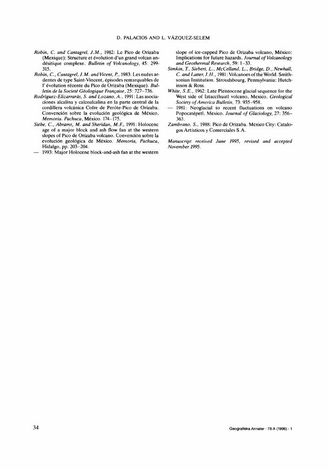
0 --1- -·: ·il- -- Jamapa Glacier Temperatures
l l l l
I I I I I
I
,. lr:
-30 cm__ , I . .
Loose blocl lay r
-60 cm ._'
1° 0.8° 0.6° 0.4° o.2° 0'
Glacier Ice with blocks
(February 14th, 1994; 12,00 Local Time; 100% Cloudy Sky; 6.7°C Environmental Temperature)
Ice covered by sediments
Rockfall talus Glacier ice Fine sand and silt layer covered by with notorlus slide planes . blocks
'
ers of rcofago i -ill
Lava tiOW at 1 53 / M
0 m ice patches, remains of 100 m
Jamapa Glacier 200 m
,4,800
_4,775
_4,750 m
300 m
Fig. 9. Cross-section of Jamapa Valley at 4,750 m of altitude and Glacier ice temperatures. See Fig. 6 for location.
(a) glacier ice intermixed with material from lat- eral moraine; and (b) interstitial ice contained in the moraine. He observed that glacier ice was more than 7 m thick, while interstitial ice exceeded 10 m. The active layer was always thin (10-20 cm in interstitial ice and 60 cm in fossil glacier ice, both
equal to the detritial layer that covers it). Heine
pointed out that the snowline (5,000 m) is above the lower limit of permafrost (4,600 m), which con- tradicts the current theory, and proposed three ex-
planations for this: (1) the permafrost in Mexico is a fossil feature; (2) at present the altitude of the snowline in central Mexico (and other dry tropical areas) is determined more by precipitation than by temperature, while in the case of the lower limit of the permafrost the main conditioning factor is
temperature; (3) although the mountains of Mexico are in the tropics, they are influenced by non-tropical phenomena such as the polar air mas- ses.
The most recent generation of talus cones is found on the western edge of today's Jamapa Gla- cier (Figs 9 and 10). As the glacier retreats, the stagnant ice is buried by mass movement deposits. The ice in contact with the wall of Sarcofago Peak, directly below an avalanche path, survives be- cause it is protected by a debris cone. The rest of
the glacier continues to disappear. Temperature readings of glacier ice were taken at 4,760 m on one of the remaining patches of the Jamapa gla- cier. They showed considerably higher tempera- tures than those of the rock glaciers. The glacier had no snow cover, since there had not been any significant snowfall in the last few weeks. The firn was only 25 cm thick and had a temperature of 0°C
(due to insolation). At a depth of 58 cm, the ice had a temperature of -0.6°C. The temperature at 90 cm was -0.9°C.
Conclusions
Jamapa Glacier has been retreating since the be-
ginning of the twentieth century, which is also the case of glaciers in other mountains in Mexico with
glaciers (White 1981, Heine 1983). The geomor- phic processes that develop as the ice retreats are
directly related to the volcanic geomorphology underlying the glacier. The most active processes are found at the base of the eastern wall of Sar-
c6fago Peak, where the structural conditions are
prone to mass movement processes and frost shat-
tering: very steep slopes; alternating layers of
permeable lava, loose pyroclastic material and im-
permeable pyroclastic material; formation of
Geografiska Annaler · 78 A (1996) · 1
.............. I I I f
I I I I II I I I I I I I
,--1--+-- I I I I I I I
I I I
i it t I I I n--~--T--T--
I I
- I I
),2° -0.4-0.6°-0.8° -1 0
31

D. PALACIOS AND L. VAZQUEZ-SELEM
Fig. 10. Slump scar on ice cover debris. Blocks and gravel layers are intercalated in the ice. See hammer for scale. A silt layer, with several slide planes, is cov- ering the ice. On top, a pebble and block layer.
Pico de Orizaba
C.-The presence of btried ice causes frequent ice slumps and
debris slides that arc also fostered by the steepness of the
colles.
Figure 11. Evolution model of Jamapa Valley.
D.-Due to the rock load on the ice. iassive flows of ice and
itoc are produced. forming small lock glaciers at the foot of
the conles
Geografiska Annaler * 78 A (1996) * 1 32

GEOMORPHIC EFFECTS OF THE RETREAT OF JAMAPA GLACIER, (MEXICO)
structural steps where snow accumulates year long and provides a constant source of water to the wall; and frequent snow avalanches that originate from the snow that accumulates on the steps.
The climatic conditions make this wall an ideal place for frost shattering processes. Temperature passes through the freezing point at least 200 days a year. The eastern exposure and the rocky wall make these maximums and minimums even more extreme (Lauer 1978).
The retreat of the glacier creates a sequence in the formation of rock talus (Fig. 11). While the gla- cier still has the capacity to flow and move along the base of the wall, it drags material with it that has fallen from the wall, which is the major source of the rock load (Fig. 11A). When the glacier can no longer flow or when its front retreats, the ice re- mains below the fall deposits and first forms a pro- longed surface at the bottom of the wall (Fig. 11B). Later, when the glacier ceases to flow, the ac- cumulation of material from the wall glacier ice is
preserved under thick debris cones and melts on the rest of the footslope.
The presence of buried ice causes frequent ice slumps and debris slides that are also fostered by the steepness of the cones (Fig. 11C). Due to the rock load on the ice, massive flows of ice and rock are produced, forming small rock glaciers at the foot of the cones (Fig. 11D).
The sequence of processes described occurs only where the sidewalls contribute enough debris to fossilize the motionless ice of the retreating gla- cier snouts. This explains the fact that the recent retreat of the glaciers has not been followed by the fossilization of glacier ice on most of the slopes of the volcano. The same applies to other mountains of central Mexico (Popocat6petl and Iztacci- huatl), where the retreat of glaciers has not led to the development of rock glaciers.
The mechanism described here can lead to the formation of small ice-cored rock glaciers. Despite their position at the foot of a talus, these rock gla- ciers could be erroneously interpreted as ice- cemented rock glaciers (Martin and Whalley 1987) unrelated to glacier ice. Studies of fossil rock gla- ciers formed from talus on deglaciated valley walls should consider the possible presence of glacier ice as a mechanism of rock glacier formation.
David Palacios, Department of A. G.R. and Physi- cal Geography, Complutense University, 28040 Madrid, Spain.
Lorenzo Vdzquez-Selem, Institute of Geography, National Autonomous University of Mexico, Ciu- dad Universitaria, 04510 Mexico, D. F, Mexico.
References Cantagrel, J.M., Gourgaud, A. and Robin, C., 1984: Repeti-
tive mixing events and Holocene pyroclastic activity at Pico de Orizaba and Popocatepetl (Mexico). Bulletin of Volcanology, 47-4(1): 735-748.
Carrasco-Niunez, G., Vallance, W.J. and Rose, WI. 1993: A voluminous avalanche-induced lahar from Pico de Orizaba volcano, Mexico: Implications for hazard as- sessment. Journal of Volcanology and Geothermal Re- search, 59: 35-46.
Heine, K., 1975a: Studien zur jungquartaren Glazialmor- phologie mexikanischer Vulkane. In: Lauer, W. (ed.) Das Mexiko-Projekt der deutschen Forschungsgemein- schaft, 7: 1-178.
- 1975b: Permafrost am Pico de Orizaba, Mexiko. Eiszeit- alter und Gegenwart, 6: 212-217.
- 1983: Mesoformen der Periglazialstufe der semihumi- den Randtropen, dargestellt an Beispilen der Cordillera Neovolcanica, Mexiko. Abh. Akademie der Wissenschaf- ten in Gottingen, Mathematisch-Physicalische Klasse, Series III, 35: 403-424.
- 1988: Late Quaternary Glacial Chronology of the Mexi- can Volcanoes. Die Geowissenschaften, 6: 197-205.
- 1994: Present and past geocryogenic processes in Mexico. Permafrost and Periglacial Processes, 5: 1-12.
Hoskuldsson, A., 1990: Les debris-avalanches du Pico de Orizaba (Mexique). Bulletin de la Section de Vol- canologie de la Societe Geologique Francaise, 19: 5-7.
- 1994: Le complexe volcanique Pico de Orizaba-Sierra Negra-Cerro de las Cumbres (sud-est Mexicain): struc- ture, dynamismes erupyifs et evaluation des aleas. Uni- versite Blaise Pascal, Clermont-Ferrand.
Hoskuldsson, A., Robin, C. and Cantagrel, J.M., 1990: Re- petitive debris avalanche events at Volcano Pico de Orizaba, Mexico and their implications for future hazard zones. IAVCEI International Volcanological Congress, Mainz, FRG, Abstracts.
Hoskuldsson, A. and Robin, C., 1993: Late Pleistocene to Holocene eruptive activity of Pico de Orizaba, Eastern Mexico. Bulletin of Volcanology, 55: 571-587.
Lauer, W., 1978: Timberline studies in Central Mexico. 10: 383-396.
Lauer, W. and Klaus, D., 1975: Geoecological investigations on the timberline of Pico de Orizaba, Mexico. Arctic and Alpine Research, 7: 315-330.
Lorenzo, J. L., 1964: Los glaciares de Mexico. Monografias del Instituto de Geofisica No. 1. Mexico City: UNAM. 1969: Condiciones periglaciares de las altas montafias de Mexico. Mexico City: Instituto Nacional de An- tropologia e Historia.
Martin, H. E. and Whalley, W B., 1987: Rock glaciers. Part 1: Rock glacier morphology: classification and distribu- tion. Progress in Physical Geography, 11: 260-282.
Mooser, E, Meyer, A.H. and McBirney, A.R., 1958: Catalogue of active volcanoes of the World, part VI, Central America. International Volcanic Association, pte. 6: 36 pp.
Geografiska Annaler * 78 A (1996) * 1 33
D. PALACIOS AND L. VAZOUEZ-SELEM
Robin, C. and Cantagrel, J.M., 1982: Le Pico de Orizaba (Mexique): Structure et evolution d'un grand volcan an- desitique complexe. Bulletin of Volcanology, 45: 299- 315.
Robin, C., Cantagrel, J.M. and Vicent, P, 1983: Les nu6es ar- dentes de type Saint-Vincent, 6pisodes remarquables de 1' evolution recente du Pico de Orizaba (Mexique). Bul- letin de la Societe Geologique Fran,aise, 25: 727-736.
Rodriguez-Elizarrards, S. and Lozano, A., 1991: Las asocia- ciones alcalina y calcoalcalina en la parte central de la cordillera volcanica Cofre de Per6te-Pico de Orizaba. Convenci6n sobre la evoluci6n geol6gica de Mexico. Memoria. Pachuca, Mexico. 174-175.
Siebe, C., Abrams, M. and Sheridan, M. , 1991: Holocene age of a major block and ash flow fan at the western slopes of Pico de Orizaba volcano. Convenci6n sobre la evoluci6n geol6gica de Mexico. Memoria, Pachuca, Hidalgo, pp. 203-204.
-1993: Major Holocene block-and-ash fan at the western
slope of ice-capped Pico de Orizaba volcano, Mexico: Implications for future hazards. Journal of Volcanology and Geothermal Research, 59: 1-33.
Simkin, T, Siebert, L., McCelland, L., Bridge, D., Newhall, C. and Latter, J. H., 1981: Volcanoes of the World. Smith- sonian Institution. Stroudsbourg, Pennsylvania: Hutch- inson & Ross.
White, S. E., 1962: Late Pleistocene glacial sequence for the West side of Iztaccihuatl volcano, Mexico. Geological Society of America Bulletin, 73: 935-958.
-1981: Neoglacial to recent fluctuations on volcano Popocatepetl, Mexico. Journal of Glaciology, 27: 356- 363.
Zambrano, S., 1988: Pico de Orizaba. Mexico City: Catalo- gos Artisticos y Comerciales S.A.
Manuscript received June 1995, revised and accepted November 1995.
Geografiska Annaler * 78 A (1996) * 1 34