Embed Size (px)
Citation preview
Geological Setting of Volcanogenic Massive Sulphide Occurrences in theMiddle Paleozoic Sicker Group of the Southeastern Cowichan Lake Uplift
(NTS 092B/13), Southern Vancouver Island1
by T. Ruks2 and J.K. Mortensen2
KEYWORDS: Sicker Group, Pa leo zoic, Van cou ver Is land,Cowichan Lake up lift, VMS de posit, stra tig ra phy, U-Pbzir con geo chron ol ogy, lithogeochemistry
INTRODUCTION
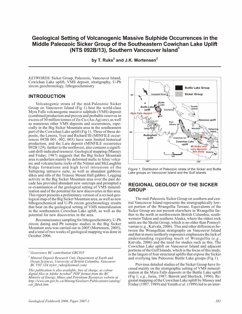
Volcanogenic strata of the mid-Pa leo zoic SickerGroup on Van cou ver Is land (Fig 1) host the world-classMyra Falls volcanogenic mas sive sul phide (VMS) de posit(com bined pro duc tion and proven and prob a ble re serves inex cess of 30 mil lion tonnes of Zn-Cu-(Au-Ag) ore), as wellas nu mer ous other VMS de pos its and oc cur rences, es pe -cially in the Big Sicker Moun tain area in the south east ernpart of the Cowichan Lake up lift (Fig 1). Three of these de -pos its, the Lenora, Tyee and Rich ard III (MINFILE oc cur -rences 092B 001, 002, 003) have seen lim ited his tor i calpro duc tion, and the Lara de posit (MINFILE oc cur rence092B 129), far ther to the north west, also con tains a sig nif i -cant drill-in di cated re source. Geo log i cal map ping (Masseyand Fri day, 1987) sug gests that the Big Sicker Moun tainarea is un der lain mainly by de formed mafic to fel sic vol ca -nic and volcaniclastic rocks of the Nitinat and McLaughlinRidge for ma tions and high level in tru sions of theSaltspring in tru sive suite, as well as abun dant gabbroicdikes and sills of the Tri as sic Mount Hall gab bro. Log gingac tiv ity in the Big Sicker Moun tain area over the past de -cade has pro vided abun dant new out crops and prompted are-ex am i na tion of the geo log i cal set ting of VMS min er al -iza tion and of the po ten tial for new dis cov er ies in this area.This re port pres ents a pre lim i nary ver sion of a re vised geo -log i cal map of the Big Sicker Moun tain area, as well as newlithogeochemical and U-Pb zir con geo chron ol ogy re sultsthat bear on the geo log i cal set ting of VMS min er al iza tionin the south east ern Cowichan Lake uplift, as well as thepotential for new discoveries in the area.
Re con nais sance sam pling for lithogeochemistry, U-Pb zir con dat ing and Pb iso to pic stud ies in the Big SickerMoun tain area was car ried out in 2005 (Mortensen, 2005),and a to tal of two weeks of geo log i cal map ping was done inOctober 2006.
REGIONAL GEOLOGY OF THE SICKERGROUP
The mid-Pa leo zoic Sicker Group on south ern and cen -tral Van cou ver Is land rep re sents the stratigraphically low -est por tion of the Wrangellia Terrane. Equiv a lents of theSicker Group are not pres ent else where in Wrangellia far -ther to the north in north west ern Brit ish Co lum bia, south -west ern Yu kon and south ern Alaska, where the old est rockunits are the Skolai Group, which is no older than Penn syl -va nian (e.g., Katvala, 2006). This and other dif fer ences be -tween the Wrangellian stra tig ra phy on Van cou ver Is landand that in more north erly ex po sures em pha sizes the lack of un der stand ing re gard ing much of Wrangellia (e.g.,Katvala, 2006) and the need for stud ies such as this. TheCowichan Lake up lift on Van cou ver Is land and ad ja centpor tions of the Gulf Is lands, which is the fo cus of this study, is the larg est of four struc tural up lifts that ex pose the Sickerand overlying late Paleozoic Buttle Lake groups (Fig 1).
Pre vi ous de tailed stud ies of the Sicker Group have fo -cused mainly on the strati graphic set ting of VMS min er al -iza tion at the Myra Falls de pos its in the Buttle Lake up lift(Fig 1; e.g., Juras, 1987; Barrett and Sherlock, 1996). Re -gional map ping of the Cowichan Lake up lift by Massey and Fri day (1987, 1989) and Yorath et al. (1999) led to an in ter -
Geo log i cal Field work 2006, Pa per 2007-1 381
1 Geoscience BC con tri bu tion GBC0352 Mineral Deposit Research Unit, Department of Earth and
Ocean Sciences, University of British Columbia, VancouverBC V6T 1Z4 ([email protected])
This publication is also available, free of charge, as colourdigital files in Adobe Acrobat® PDF format from the BCMinistry of Energy, Mines and Petroleum Resources website athttp://www.em.gov.bc.ca/Mining/Geolsurv/Publications/catalog/cat_fldwk.htm
km
0 25 50Victoria
Tofino
PortAlberni
Nanaimo
Sidney
TexadaIsland
Cowichan Lk
ButtleLake
Campbell River
Courtenay
Buttle Lakeuplift
Bedingfielduplift
Cowichan Lakeuplift
SaltspringIsland
Myra Falls deposit
Mt Sicker andLara deposits
Nanoose uplift
Buttle Lake Group
Sicker Group50°
49°
126° 124°
:this study
Fig ure 1. Dis tri bu tion of Pa leo zoic strata of the Sicker and ButtleLake groups on Van cou ver Is land and the Gulf Is lands.
preted strati graphic frame work that may be ap pli ca ble tothe en tire Sicker Group (Fig. 2). This strati graphic frame -work, how ever, is based on map ping in only one of the fourmain up lifts of Sicker Group rocks, and is sup ported by avery lim ited amount of biostratigraphic and iso to pic agedata (e.g., Brandon et al., 1986). Ma jor along and across-strike fa cies changes and geo chem i cal vari a tions are to beex pected in sub ma rine vol ca nic se quences such as the onethat forms the Sicker Group; hence, the re gional ap pli ca bil -ity of the pro posed strati graphic frame work of Yorath et al.(1999) must be tested with de tailed map ping andlithogeochemical and U-Pb dat ing stud ies. This is crit i calfor re gional ex plo ra tion for VMS de pos its within theSicker Group. For ex am ple, the ques tion of whether VMSde pos its and oc cur rences in the Cowichan Lake up lift areall of the same age, and how their hostrocks are di rectly cor -re la tive with those that host the Myra Falls de posit, are ofob vi ous im por tance.
The Sicker Group within the Cowichan Lake up lift ispres ently in ter preted to rep re sent three dis tinct and re gion -ally mappable vol ca nic and volcaniclastic as sem blages that to gether are thought to re cord the evo lu tion of an oce anicmag matic arc (Massey, 1995a, b, c; Yorath et al., 1999).The Duck Lake For ma tion, at the base of the sec tion, con -sists of dom i nantly tholeiitic ba salt, which passes up wardinto calcalkaline lava. The low er most Duck Lake For ma -tion yields mainly nor mal mid-ocean-ridge ba salt (N-MORB) geo chem i cal sig na tures (Massey, 1995a) and is in -ter preted to rep re sent the oce anic crust base ment on whichthe Sicker arc was built. The up per por tions of the DuckLake For ma tion yield tholeiitic to calcalkaline com po si -tions and may rep re sent prim i tive arc rocks. The Duck Lake For ma tion is over lain by the Nitinat For ma tion, whichcom prises mafic, sub ma rine, vol ca nic and volcaniclasticrocks with dom i nantly calcalkaline com po si tions and traceel e ment sig na tures typ i cal of vol ca nic arc set tings. Theserocks are in ter preted to rep re sent an early stage of arc de -vel op ment. The andesitic to mainly dacitic and rhyoliticMcLaughlin Ridge For ma tion that over lies the Nitinat andhosts the Myra Falls de posit re flects a more evolved stageof arc ac tiv ity. Erup tion of Nitinat vol ca nic andvolcaniclastic rocks ap pears to have oc curred from sev eralwidely scat tered cen tres, whereas the McLaughlin RidgeFor ma tion within the Cowichan Lake up lift is thought torep re sent erup tion from one or more ma jor vol ca nic ed i -fices. The abun dance of prox i mal fel sic volcaniclastic
rocks and the pres ence of vo lu mi nous comagmatic fel sicin tru sions (Saltspring in tru sions) in the Saltspring Is landand Duncan area (Fig 1) in di cates that one of these ma jorvol ca nic cen tres was lo cated in this area. Plant ma te rial andtrace fos sils in di cate that at least a mi nor amount of theMcLaughlin Ridge vol ca nism oc curred in a subaerial set -ting. De po si tion of the over ly ing Fourth Lake For ma tion ofthe Buttle Lake Group fol lowed the ces sa tion of Sicker arcmagmatism, and scarce mafic vol ca nic rocks con tainedwithin the Fourth Lake For ma tion yield en riched tholeiiticrather than the calcalkaline com po si tions that char ac ter izethe McLaughlin Ridge. Massey (1995a) speculated that theButtle Lake Group may represent a marginal-basinassemblage that developed on top of the Sicker arc.
Stud ies of the Sicker and Buttle Lake groups on south -ern Saltspring Is land at the south east ern end of theCowichan Lake up lift by Sluggett (2003) and Sluggett andMortensen (2003) pro vided new U-Pb zir con age con -straints on both fel sic vol ca nic rocks of the McLaughlinRidge For ma tion and sev eral bod ies of Saltspring in tru -sions. This work dem on strates that two dis tinct ep i sodes offel sic magmatism oc curred in this por tion of the CowichanLake up lift. One sam ple of fel sic vol ca nic rocks from theMcLaughlin Ridge For ma tion and three sam ples ofSaltspring in tru sions yielded U-Pb ages in the range356.5 to 359.1 Ma. A some what older U-Pb age of369.7 Ma was ob tained from a sep a rate body of theSaltspring in tru sions at Burgoyne Bay on the south westside of Saltspring Is land, in di cat ing that magmatism rep re -sented by the McLaughlin Ridge For ma tion and as so ci atedSaltspring in tru sions oc curred over a time span of at least15 m.y. There is in suf fi cient age con trol avail able at thispoint to de ter mine whether the magmatism was con tin u ousor ep i sodic dur ing this time pe riod. Lithogeochemical datare ported by Sluggett (2003) for sam ples of the McLaughlinRidge and Nitinat for ma tions on Saltspring Is land, to gether with data pre vi ously re ported by Massey (1995a, b, c), pro -vide a geo chem i cal frame work with which to compare thenew results from the Big Sicker Mountain study area.
RESULTS OF NEW MAPPING IN THEBIG SICKER MOUNTAIN AREA
Field Geology
Pre lim i nary map ping of an area of Big Sicker Moun -tain cov er ing ap prox i mately 25 km2 was con ducted over 12 days in Oc to ber 2006 (Fig 3). The map ping con cen tratedpri mar ily in the area of the past-pro duc ing Lenora, Rich ardIII and Tyee VMS de pos its, and nearby MINFILE (2006)oc cur rences. Bed rock out crop on Big Sicker Moun tain isgen er ally poor and is mainly re stricted to log ging-road cutsand slashes. As a re sult, con tact lo ca tions be tween ma jorrock types are mostly inferred.
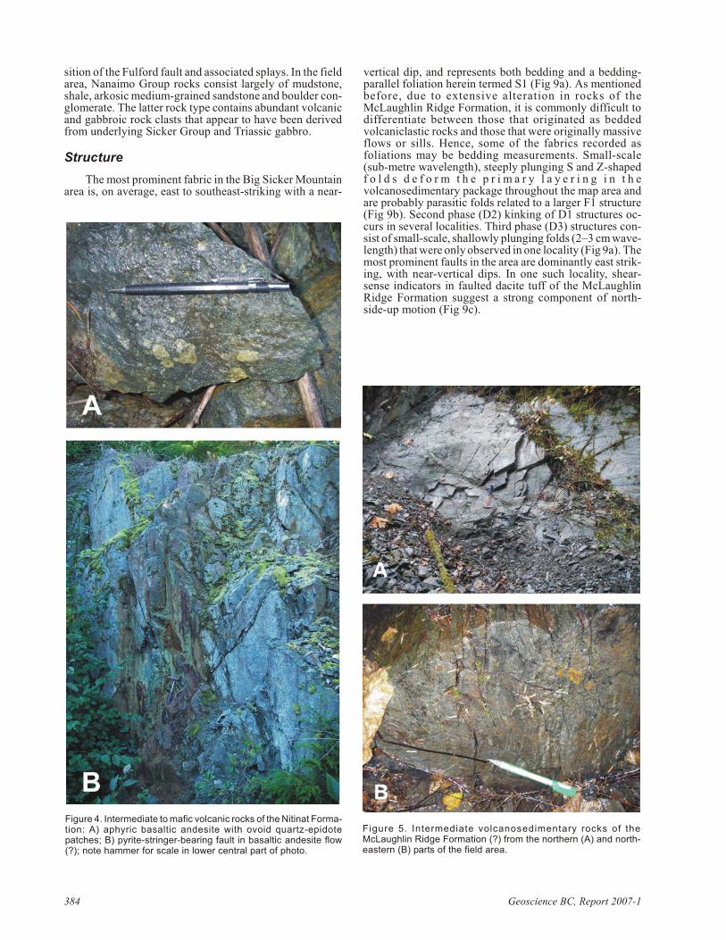
The old est rocks in the Big Sicker Moun tain area aremafic vol ca nic rocks as signed to the Nitinat For ma tion(Massey and Fri day, 1987). Dur ing the course of 2006 map -ping, rocks of the Nitinat For ma tion were en coun tered only in a small area along the west ern flanks of Lit tle SickerMoun tain (Fig 3). They con sist of dark green, dom i nantlyaphyric ba salt with abun dant ovoid epidote-quartz al ter -ation patches up to 4 to 5 cm in di am e ter (Fig 4a). Sul phidemin er al iza tion is ob served in one out crop of Nitinat For ma -tion, and con sists of py rite string ers up to 5 cm in widthhosted in a ver ti cally dip ping fault zone ap prox i mately 2 m
382 Geoscience BC, Re port 2007-1
Fig ure 2. Strati graphic no men cla ture for the Sicker and Buttle Lake groups on Van cou ver Is land.
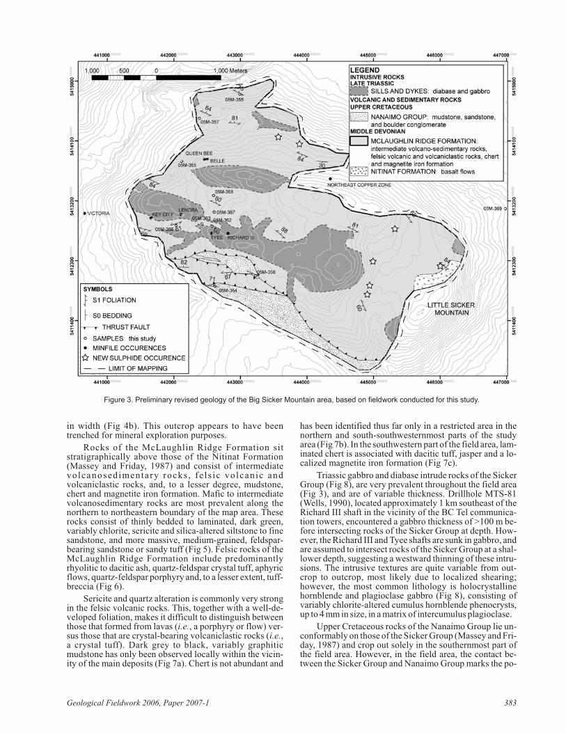
in width (Fig 4b). This out crop ap pears to have beentrenched for mineral exploration purposes.
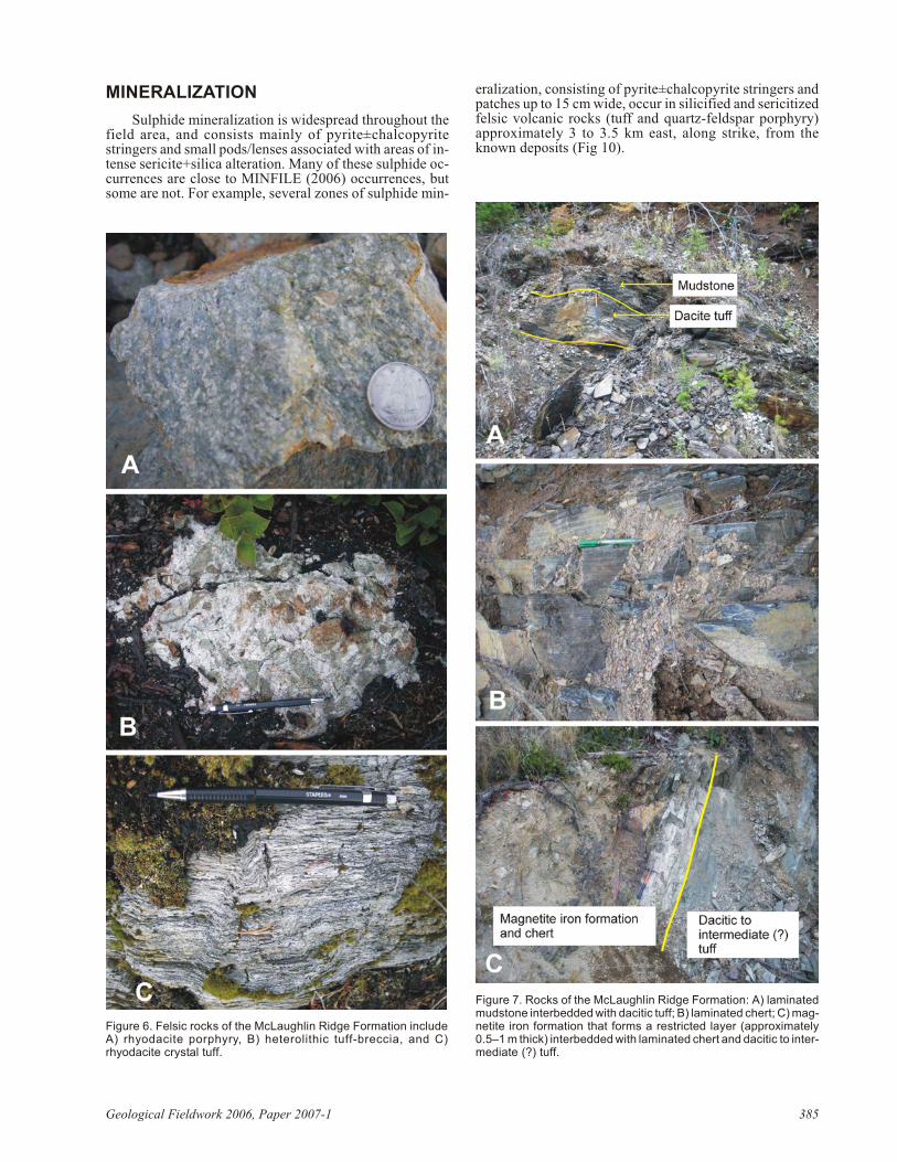
Rocks of the McLaughlin Ridge For ma tion sitstratigraphically above those of the Nitinat For ma tion(Massey and Fri day, 1987) and con sist of in ter me di atevolcanosedimentary rocks , fe l s ic vol ca n ic andvolcaniclastic rocks, and, to a lesser de gree, mudstone,chert and mag ne tite iron for ma tion. Mafic to in ter me di atevolcanosedimentary rocks are most prev a lent along thenorth ern to north east ern bound ary of the map area. Theserocks con sist of thinly bed ded to lam i nated, dark green,vari ably chlorite, seri cite and sil ica-al tered siltstone to finesand stone, and more mas sive, me dium-grained, feld spar-bear ing sand stone or sandy tuff (Fig 5). Fel sic rocks of theMcLaughlin Ridge For ma tion in clude pre dom i nantlyrhyolitic to dacitic ash, quartz-feld spar crys tal tuff, aphyricflows, quartz-feld spar por phyry and, to a lesser extent, tuff-breccia (Fig 6).
Seri cite and quartz al ter ation is com monly very strongin the fel sic vol ca nic rocks. This, to gether with a well-de -vel oped fo li a tion, makes it dif fi cult to dis tin guish be tweenthose that formed from lavas (i.e., a por phyry or flow) ver -sus those that are crys tal-bear ing volcaniclastic rocks (i.e.,a crys tal tuff). Dark grey to black, vari ably gra phiticmudstone has only been ob served lo cally within the vi cin -ity of the main de pos its (Fig 7a). Chert is not abun dant and
has been iden ti fied thus far only in a re stricted area in thenorth ern and south-southwesternmost parts of the studyarea (Fig 7b). In the south west ern part of the field area, lam -i nated chert is as so ci ated with dacitic tuff, jas per and a lo -cal ized magnetite iron formation (Fig 7c).
Tri as sic gab bro and diabase in trude rocks of the SickerGroup (Fig 8), are very prev a lent through out the field area(Fig 3), and are of vari able thick ness. Drillhole MTS-81(Wells, 1990), lo cated ap prox i mately 1 km south east of theRich ard III shaft in the vi cin ity of the BC Tel com mu ni ca -tion tow ers, en coun tered a gab bro thick ness of >100 m be -fore in ter sect ing rocks of the Sicker Group at depth. How -ever, the Rich ard III and Tyee shafts are sunk in gab bro, and are as sumed to in ter sect rocks of the Sicker Group at a shal -lower depth, sug gest ing a west ward thin ning of these in tru -sions. The in tru sive tex tures are quite vari able from out -crop to out crop, most likely due to lo cal ized shear ing;how ever, the most com mon li thol ogy is holocrystallinehornblende and plagioclase gab bro (Fig 8), con sist ing ofvari ably chlorite-al tered cu mu lus hornblende pheno crysts,up to 4 mm in size, in a matrix of intercumulus plagioclase.
Up per Cre ta ceous rocks of the Nanaimo Group lie un -con form ably on those of the Sicker Group (Massey and Fri -day, 1987) and crop out solely in the south ern most part ofthe field area. How ever, in the field area, the con tact be -tween the Sicker Group and Nanaimo Group marks the po -
Geo log i cal Field work 2006, Pa per 2007-1 383
Fig ure 3. Pre lim i nary re vised ge ol ogy of the Big Sicker Moun tain area, based on field work con ducted for this study.
si tion of the Fulford fault and as so ci ated splays. In the fieldarea, Nanaimo Group rocks con sist largely of mudstone,shale, arkosic me dium-grained sand stone and boul der con -glom er ate. The lat ter rock type con tains abun dant vol ca nicand gabbroic rock clasts that ap pear to have been de rivedfrom un der ly ing Sicker Group and Triassic gabbro.
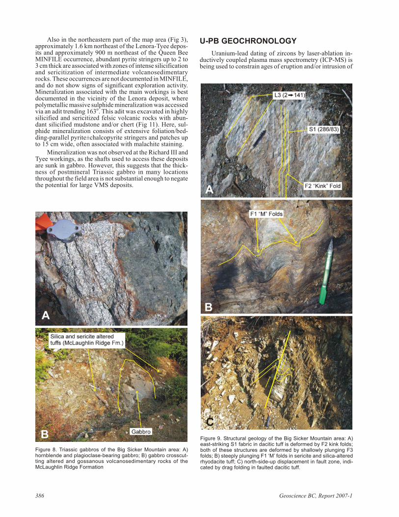
Structure
The most prom i nent fab ric in the Big Sicker Moun tainarea is, on av er age, east to south east-strik ing with a near-
ver ti cal dip, and rep re sents both bed ding and a bed ding-par al lel fo li a tion herein termed S1 (Fig 9a). As men tionedbe fore, due to ex ten sive al ter ation in rocks of theMcLaughlin Ridge For ma tion, it is com monly dif fi cult todif fer en ti ate be tween those that orig i nated as bed dedvolcaniclastic rocks and those that were orig i nally mas siveflows or sills. Hence, some of the fab rics re corded asfoliations may be bed ding mea sure ments. Small-scale(sub-metre wave length), steeply plung ing S and Z-shapedf o l d s d e f o r m t h e p r i m a r y l a y e r i n g i n t h evolcanosedimentary pack age through out the map area andare prob a bly par a sitic folds re lated to a larger F1 struc ture(Fig 9b). Sec ond phase (D2) kink ing of D1 struc tures oc -curs in sev eral lo cal i ties. Third phase (D3) struc tures con -sist of small-scale, shal lowly plung ing folds (2–3 cm wave -length) that were only ob served in one lo cal ity (Fig 9a). The most prom i nent faults in the area are dom i nantly east strik -ing, with near-ver ti cal dips. In one such lo cal ity, shear-sense in di ca tors in faulted dacite tuff of the McLaughlinRidge Formation suggest a strong component of north-side-up motion (Fig 9c).
384 Geoscience BC, Re port 2007-1
Fig ure 4. In ter me di ate to mafic vol ca nic rocks of the Nitinat For ma -tion: A) aphyric ba saltic an de site with ovoid quartz-epidotepatches; B) py rite-stringer-bear ing fault in ba saltic an de site flow(?); note ham mer for scale in lower cen tral part of photo.
Fig ure 5. In ter me di ate volcanosedimentary rocks of theMcLaughlin Ridge For ma tion (?) from the north ern (A) and north -east ern (B) parts of the field area.
MINERALIZATION
Sul phide min er al iza tion is wide spread through out thefield area, and con sists mainly of py rite±chal co py ritestring ers and small pods/lenses as so ci ated with ar eas of in -tense seri cite+sil ica al ter ation. Many of these sul phide oc -cur rences are close to MINFILE (2006) oc cur rences, butsome are not. For ex am ple, sev eral zones of sul phide min -
er al iza tion, con sist ing of py rite±chal co py rite string ers andpatches up to 15 cm wide, oc cur in si lici fied and sericitizedfel sic vol ca nic rocks (tuff and quartz-feld spar por phyry)ap prox i mately 3 to 3.5 km east, along strike, from theknown deposits (Fig 10).
Geo log i cal Field work 2006, Pa per 2007-1 385
Fig ure 6. Fel sic rocks of the McLaughlin Ridge For ma tion in cludeA) rhyodacite por phyry, B) heterolithic tuff-brec cia, and C)rhyodacite crys tal tuff.
Fig ure 7. Rocks of the McLaughlin Ridge For ma tion: A) lam i natedmudstone interbedded with dacitic tuff; B) lam i nated chert; C) mag -ne tite iron for ma tion that forms a re stricted layer (ap prox i mately0.5–1 m thick) interbedded with lam i nated chert and dacitic to in ter -me di ate (?) tuff.
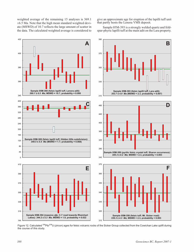
Also in the north east ern part of the map area (Fig 3),ap prox i mately 1.6 km north east of the Lenora-Tyee de pos -its and ap prox i mately 900 m north east of the Queen BeeMINFILE oc cur rence, abun dant py rite string ers up to 2 to3 cm thick are as so ci ated with zones of in tense sili ci fi ca tion and sericitization of in ter me di ate volcanosedimentaryrocks. These oc cur rences are not doc u mented in MINFILE, and do not show signs of sig nif i cant ex plo ra tion ac tiv ity.Min er al iza tion as so ci ated with the main work ings is bestdoc u mented in the vi cin ity of the Lenora de posit, wherepolymetallic mas sive sul phide min er al iza tion was ac cessed via an adit trending 163o. This adit was ex ca vated in highlysi lici fied and sericitized fel sic vol ca nic rocks with abun -dant si lici fied mudstone and/or chert (Fig 11). Here, sul -phide min er al iza tion con sists of ex ten sive fo li a tion/bed -ding-par al lel py rite±chal co py rite stringers and patches upto 15 cm wide, often associated with malachite staining.
Min er al iza tion was not ob served at the Rich ard III andTyee work ings, as the shafts used to ac cess these de pos itsare sunk in gab bro. How ever, this sug gests that the thick -ness of postmineral Tri as sic gab bro in many lo ca tionsthrough out the field area is not sub stan tial enough to ne gate the po ten tial for large VMS deposits.
U-PB GEOCHRONOLOGY
Ura nium-lead dat ing of zir cons by la ser-ab la tion in -duc tively cou pled plasma mass spec trom e try (ICP-MS) isbe ing used to con strain ages of erup tion and/or in tru sion of
386 Geoscience BC, Re port 2007-1
Fig ure 8. Tri as sic gab bros of the Big Sicker Moun tain area: A)hornblende and plagioclase-bear ing gab bro; B) gab bro cross cut -ting al tered and gos sa nous volcanosedimentary rocks of theMcLaughlin Ridge For ma tion
Fig ure 9. Struc tural ge ol ogy of the Big Sicker Moun tain area: A)east-strik ing S1 fab ric in dacitic tuff is de formed by F2 kink folds;both of these struc tures are de formed by shal lowly plung ing F3folds; B) steeply plung ing F1 ‘M’ folds in seri cite and sil ica-al teredrhyodacite tuff; C) north-side-up dis place ment in fault zone, in di -cated by drag fold ing in faulted dacitic tuff.
ig ne ous rock units and to con struct a chrono -stratigraphic frame work for magmatism in theSicker Group. This pa per in cludes pre lim i naryU-Pb zir con ages for six vol ca nic units in thesouth east ern Cowichan Lake up lift. Zir conswere re cov ered from sam ples weigh ing ap prox -i mately 10 kg us ing con ven tional crush ing,grind ing, wet shak ing ta ble, heavy liq uids andmag netic meth ods. Se lected grains weremounted in ther mal-set ting ep oxy; the grainmounts were care fully ground down un til the in -te rior of the in di vid ual grains were ex posed. The ground sur faces were then brought to a high pol -ish us ing se quen tially finer di a mond pastes. Thesur faces of the mounts were then washed withdi lute ni tric acid for ten min utes and rinsed withultrapure wa ter. Anal y ses were done in the Pa -cific Cen tre for Iso to pic and Geo chem i cal Re -search (PCIGR) fa cil ity at the Uni ver sity ofBrit ish Co lum bia (UBC), us ing a New Wave™213 nm Nd-YAG la ser cou pled to a ThermoFinnigan™ Element2 high-res o lu tion ICP-MS.Ab la tion took place within a New Wave‘Supercell’ ab la tion cham ber that is de signed to
achieve very high ef fi ciency en train ment of aero sols intothe car rier gas. He lium was used as the car rier gas for all ex -per i ments, and gas flow rates, to gether with other pa ram e -ters such as torch po si tion, were op ti mized prior to be gin -ning a se ries of anal y ses. A 25 µm spot with 60% la serpower was used, mak ing line scans rather than spot anal y -ses in or der to avoid within-run el e men tal frac tion. Eachanal y sis con sists of a 7 sec ond back ground mea sure ment(la ser off), fol lowed by an ap prox i mately 28 sec ond dataac qui si tion pe riod with the la ser fir ing. A typ i cal an a lyt i calses sion con sists of four anal y ses of the stan dard zir con, fol -lowed by four anal y ses of un known zir cons, two stan dardanal y ses, four un known anal y ses, etc., and fi nally fourstan dard anal y ses. Data were re duced us ing the GLITTERsoft ware, mar keted by the Geo chem i cal Evo lu tion andMetallogeny of Con ti nents (GEMOC) group at Macquarrie Uni ver sity, which au to mat i cally subtracts back groundmea sure ments, prop a gates all an a lyt i cal er rors and cal cu -lates iso to pic ra tios and ages. Fi nal ages for rel a tivelyyoung (Phanerozoic) zir cons are typ i cally based on aweighted av er age of the cal cu lated 206Pb/238U ages for 10 to20 individual analyses. Final interpretation and plotting ofthe analytical results employed the Isoplot software writtenby K.R. Ludwig.
Zir cons re cov ered from all of the Sicker Group vol ca -nic rocks form stubby, subhedral to euhedral pink ish prisms with vague in ter nal growth zon ing but no vis i ble in her itedcores. Ap prox i mately 25 grains were mounted from eachsam ple and 12 to 20 in di vid ual anal y ses were car ried outfor each sam ple. The re sults are plot ted in Fig ure 12, whichshows a com pi la tion of the cal cu lated 206Pb/238U ages forin di vid ual anal y ses with a calculated weighted-averageage.
Sam ple 05M-366 is from strongly fo li ated, sparselyquartz-phyric lapilli tuff col lected 5 m north of the Lenoraadit. Six teen in di vid ual anal y ses were done and there iscon sid er able scat ter in the data (Fig 12a). One of the anal y -ses gives a 206Pb/238U age of 403 Ma and is re jected as prob -a bly a xenocrystic grain in cor po rated into the tuff. A
Geo log i cal Field work 2006, Pa per 2007-1 387
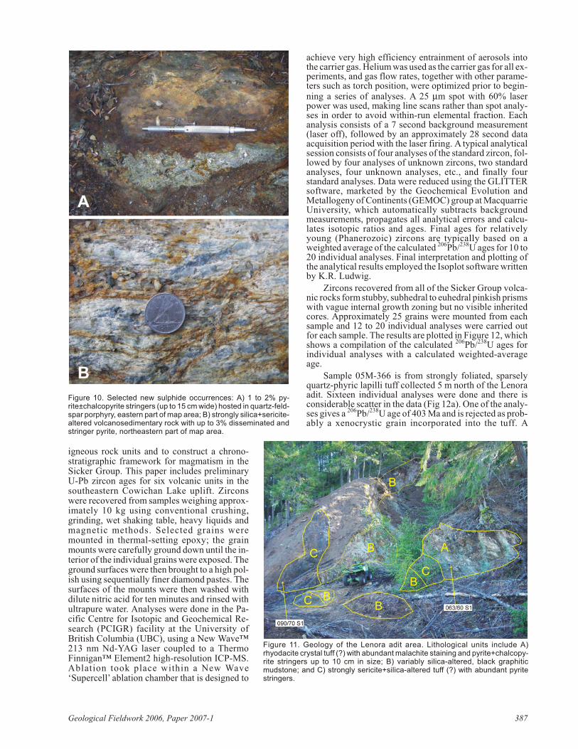
Fig ure 10. Se lected new sul phide oc cur rences: A) 1 to 2% py -rite±chal co py rite string ers (up to 15 cm wide) hosted in quartz-feld -spar por phyry, east ern part of map area; B) strongly sil ica+seri cite-al tered volcanosedimentary rock with up to 3% dis sem i nated andstringer py rite, north east ern part of map area.
Fig ure 11. Ge ol ogy of the Lenora adit area. Lithological units in clude A)rhyodacite crys tal tuff (?) with abun dant mal a chite stain ing and py rite+chal co py -rite string ers up to 10 cm in size; B) vari ably sil ica-al tered, black gra phiticmudstone; and C) strongly seri cite+sil ica-al tered tuff (?) with abun dant py ritestring ers.
weighted av er age of the re main ing 15 anal y ses is 369.1±6.5 Ma. Note that the high mean stan dard weighted de vi -ate (MSWD) of 10.7 re flects the large amount of scat ter inthe data. The cal cu lated weighted av er age is con sid ered to
give an ap prox i mate age for erup tion of the lapilli tuff unitthat partly hosts the Lenora VMS deposit.
Sam ple 05M-393 is a strongly welded quartz and feld -spar-phyric lapilli tuff at the main adit on the Lara prop erty.
388 Geoscience BC, Re port 2007-1
0
40
80
120
160
200
240
280
320
360
400
Sample 05M-369 (felsic lapilli tuff; Hidden Hills subdivision):349.5 ± 5.5 Ma (MSWD = 1.7; probability = 0.068)
310
330
350
370
390
Sample 05M-393 (felsic lapilli tuff, Lara adit):353.7 ± 4.9 Ma (MSWD = 2.3, probability = 0.007)
290
310
330
350
370
390
410
Sample 05M-394 (massive qfp; C-7 road towards RheinhartLakes): 344.2 ± 5.3 Ma; MSWD = 1.9, probability = 0.022
310
320
330
340
350
360
370
Sample 05M-356 (felsic tuff; Mt. Sicker road):339.3 ± 4.3 Ma; MSWD = 2.3, probability = 0.003
240
280
320
360
400
440
480
Sample 05M-389 (pyritic felsic crystal tuff; Sharon occurrence):345.3 ± 8.2 Ma; MSWD = 2.3, probability = 0.003
340
360
380
400
420
Sample 05M-366 (felsic lapilli tuff, Lenora adit):369.1 ± 6.5 Ma; MSWD = 10.7, probability = 0.000
A B
C D
E F
Fig ure 12. Cal cu lated 206Pb/238U (zir con) ages for fel sic vol ca nic rocks of the Sicker Group col lected from the Cowichan Lake up lift dur ingthe course of this study.
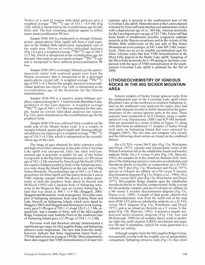
Twelve of a to tal of six teen in di vid ual anal y ses give aweighted av er age 206Pb/238U age of 353.7 ±4.9 Ma (Fig12b), which is in ter preted as the crys tal li za tion age for thisfel sic unit. The four re main ing anal y ses ap pear to re flectmi nor postcrystallization Pb loss.
Sam ple 05M-369 is a mod er ately to strongly fo li ated,py ritic, quartz-phyric fel sic lapilli tuff from a road ex po -sure in the Hid den Hills sub di vi sion, im me di ately east ofthe study area. Eleven of twelve in di vid ual anal y ses(Fig 12c) give a weighted av er age 206Pb/238U age of 349.5±5.5 Ma, which is in ter preted as the crys tal li za tion age forthis unit. One anal y sis gives a much youn ger 206Pb/238U ageand is in ter preted to have suf fered postcrystallization Pbloss.
Sam ple 05M-389 is a strongly fo li ated, py ritic quartz-mus co vite schist with scat tered quartz eyes from theSharon oc cur rence that is in ter preted to be a de formedquartz-phyric crys tal tuff. A weighted av er age 206Pb/238Uage of 345.3 ±8.2 Ma for this sam ple, based on six teen in di -vid ual anal y ses (no re jects; Fig 12d), is in ter preted as thecrys tal li za tion age of the hostrocks for the Sharonmineralization.
Sam ple 05M-394 is a mas sive quartz-feld spar por -phyry ex posed along the C-7 road to wards Rheinhart Lake,north west of the Lara de posit. A weighted av er age206Pb/238U age of 344.2 ±5.3 Ma was ob tained for this sam -ple, based on six teen in di vid ual anal y ses (no re jects;Fig 12e), and is in ter preted as the crys tal li za tion age for theporphyry body.
Sam ple 05M-356 was col lected from a roadcut on thesouth side of the Mount Sicker road. It is a weakly tostrongly fo li ated, quartz-phyric lapilli tuff. Six teen in di vid -ual anal y ses (no re jects) give a weighted av er age 206Pb/238U age of 339.3 ±4.3 Ma, which is in ter preted as the crys tal li -za tion age of this unit.
The range of ages ob tained for fel sic ex tru sive rocksand high-level fel sic in tru sions in this part of the CowichanLake up lift was un ex pected. Only one other well-con -strained age is pres ently avail able for any of the SickerGroup units in the Big Sicker Moun tain area: a U-Pb zir conage of 362 ±2 Ma re ported by Parrish and McNicoll (1992)for a quartz-feld spar por phyry body of the Saltspring in tru -sive suite along the Is land High way on the east side of BigSicker Moun tain. The pre lim i nary age of 369.1 ±6.5 Ma re -ported here for fel sic lapilli tuff that partly hosts the LenoraVMS orebody (sam ple 05M-366 above) is within un cer -tainty of both the por phyry body dated by Parrish andMcNicoll (1992) and a sep a rate body of Saltspring in tru -sions in the Burgoyne Bay area on west ern Saltspring Is -land that was dated at 369.7 ±1.9 Ma (Sluggett, 2003;Sluggett and Mortensen, work in prog ress). Two other sam -ples of Saltspring in tru sions from near Ers kine Point andLake Stowell on Saltspring Is land, which were dated bySluggett (2003) and Sluggett and Mortensen (work in prog -ress), gave U-Pb ages of 359.1 ±1.4 and 356.5 ±1.7 Ma, re -spec tively, and a sam ple of fel sic tuff of the McLaughlinRidge For ma tion near Isabella Point in the south west partof Saltspring Is land gave a U-Pb age of 354.1 ±1.2 Ma.
Pre vi ous work had there fore al ready dem on strated asig nif i cant age range for McLaughlin Ridge and Saltspringintrusive suite magmatism. The new data from this study,how ever, in di cate that fel sic magmatism lasted from ca.370 Ma un til at least as young as 339 Ma. More im por tantly, these data sug gest that VMS min er al iza tion of at least two
sep a rate ages is pres ent in the south east ern part of theCowichan Lake up lift. Min er al iza tion at the Lenora de posit is hosted by fel sic tuff (and interlayered sed i mentary rocks) with a depositional age of ca. 369 Ma, whereas hostrocksfor the Lara de posit give an age of 353.7 Ma. Fel sic tuff thathosts bands of stratabound, pos si bly syngenetic sul phidemin erals at the Sharon oc cur rence and in the vi cin ity of theHid den Hills sub di vi sion on the east side of Big SickerMoun tain are even youn ger, at 345.3 and 349.5 Ma, re spec -tively. There are as yet no re li able crys tal li za tion ages forfel sic vol ca nic rocks that host VMS min er al iza tion at theMyra Falls de posit in the Buttle Lake up lift. Sam pling ofthe Myra Falls hostrocks for U-Pb dat ing to fa cil i tate com -par i son with the ages of VMS min er al iza tion in the south -east ern Cowichan Lake up lift is planned for the fall of2006.
LITHOGEOCHEMISTRY OF IGNEOUSROCKS IN THE BIG SICKER MOUNTAINAREA
Six teen sam ples of Sicker Group ig ne ous rocks fromthe south east ern part of the Cowichan Lake up lift (fromRheinhart Lake on the north west to south ern Saltspring Is -land on the south east) were an a lyzed for ma jor, trace andrare earth el e ments in or der to better char ac ter ize the pet ro -chem is try of the var i ous ig ne ous units in the area. Theseanal y ses were con ducted at ALS Chemex, us ing a com bi -na tion of x-ray flu o res cence (XRF) and ICP-MS meth ods.Data are pre sented in a se ries of plots in Fig ure 13, alongwith data from an ad di tional 11 sam ples of Sicker Grouprock units on Saltspring Is land that were re ported bySluggett (2003). The two data sets com pare very closelyand the fol low ing observations are based on the combineddataset.
On a Zr/TiO2 ver sus Nb/Y plot (Fig 13a; Winchesterand Floyd, 1977), vol ca nic and volcaniclastic rocks of theNitinat For ma tion fall in the subalkaline ba salt and ba saltican de site fields. On a V ver sus Ti plot (Fig 13b; Shervais,1982), the sam ples lie in the is land arc tholeiite field. Sam -ples of the Saltspring in tru sive suite plot as subalkaline andrhyodacite/dacite to rhy o lite in com po si tion on a Zr/TiO2
ver sus Nb/Y plot (Fig 13a; Winchester and Floyd, 1977),and are of vol ca nic arc af fin ity on a Nb ver sus Y tec tonicdis crim i na tion di a gram (Fig 13c; Pearce et al., 1984). On aZr/TiO2 ver sus Nb/Y plot (Fig 13a; Winchester and Floyd,1977), McLaughlin Ridge sam ples span the subalkalinerhyodacite/dacite to rhy o lite compositional fields (ex ceptfor one andesitic sam ple), and are of vol ca nic arc af fin ity on a Nb ver sus Y tec tonic dis crim i na tion di a gram (Fig 13c;Pearce et al., 1984). A sam ple of dark green, chlorite-richvolcanosedimentary rock from the north end of the maparea (05M-355) plots as subalkaline an de site on a Zr/TiO2
ver sus Nb/Y di a gram (Fig 13a; Winchester and Floyd,1977), and as an is land arc tholeiite on a V ver sus Ti di a -gram (Fig 13b; Shervais, 1982). A prim i tive man tle nor -mal ized multi-el e ment di a gram (Fig 13d; Sun andMcDonough, 1989) for all sam ples shows weak to mod er -ate light rare earth el e ment (LREE) en rich ment and neg a -tive Nb and Ti anomalies, typical for rocks generated in avolcanic arc setting.
Al though sam ples from the McLaughlin Ridge For ma -tion par tially over lap with the roughly co eval and prob a blycomagmatic Saltspring in tru sive suite (Fig 13), they show
Geo log i cal Field work 2006, Pa per 2007-1 389
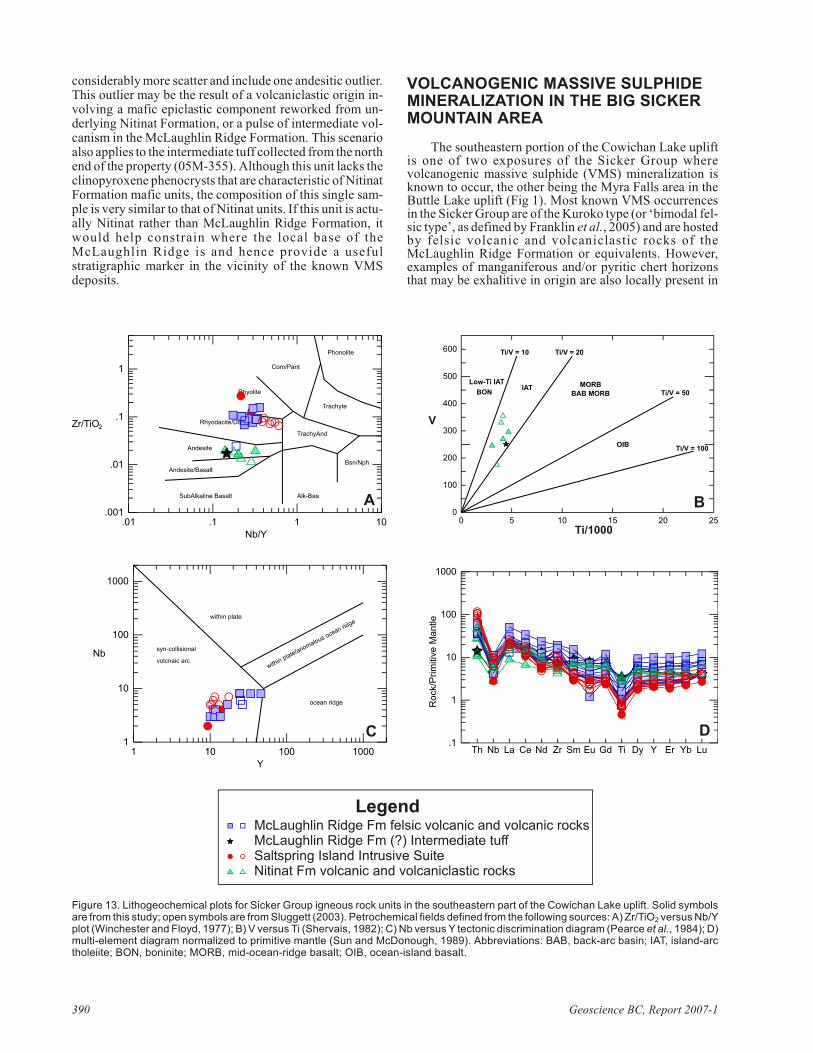
con sid er ably more scat ter and in clude one andesitic out lier. This out lier may be the re sult of a volcaniclastic or i gin in -volv ing a mafic epiclastic com po nent re worked from un -der ly ing Nitinat For ma tion, or a pulse of in ter me di ate vol -ca nism in the McLaughlin Ridge For ma tion. This sce narioalso ap plies to the in ter me di ate tuff col lected from the north end of the prop erty (05M-355). Al though this unit lacks theclinopyroxene pheno crysts that are char ac ter is tic of Nitinat For ma tion mafic units, the com po si tion of this sin gle sam -ple is very sim i lar to that of Nitinat units. If this unit is ac tu -ally Nitinat rather than McLaughlin Ridge For ma tion, itwould help con strain where the lo cal base of theMcLaughlin Ridge is and hence pro vide a use fulstratigraphic marker in the vicinity of the known VMSdeposits.
VOLCANOGENIC MASSIVE SULPHIDEMINERALIZATION IN THE BIG SICKERMOUNTAIN AREA
The south east ern por tion of the Cowichan Lake up liftis one of two ex po sures of the Sicker Group wherevolcanogenic mas sive sul phide (VMS) min er al iza tion isknown to oc cur, the other be ing the Myra Falls area in theButtle Lake up lift (Fig 1). Most known VMS oc cur rencesin the Sicker Group are of the Kuroko type (or ‘bi modal fel -sic type’, as de fined by Frank lin et al., 2005) and are hostedby fel sic vol ca nic and volcaniclastic rocks of theMcLaughlin Ridge For ma tion or equiv a lents. How ever,ex am ples of manganiferous and/or py ritic chert ho ri zonsthat may be exhalitive in or i gin are also lo cally pres ent in
390 Geoscience BC, Re port 2007-1
LegendMcLaughlin Ridge Fm felsic volcanic and volcanic rocksMcLaughlin Ridge Fm (?) Intermediate tuffSaltspring Island Intrusive SuiteNitinat Fm volcanic and volcaniclastic rocks
.1
1
10
100
1000
Th Nb La Ce Nd Zr Sm Eu Gd Ti Dy Y Er Yb Lu
D
Ro
ck/P
rim
itiv
e M
an
tle
A
.01 .1 1 10.001
.01
.1
1
Zr/TiO2
Nb/Y
SubAlkaline Basalt
Andesite/Basalt
Andesite
Rhyodacite/Dacite
Rhyolite
Alk-Bas
TrachyAnd
Com/Pant
Phonolite
Trachyte
Bsn/Nph
1 10 100 10001
10
100
1000
Nb
Y
syn-collisional
volcnaic arc
within plate
ocean ridge
C
within plate/anomalous ocean ridge
0 5 10 15 20 250
100
200
300
400
500
600
V
Ti/1000
Low-Ti IAT
BONIAT MORB
BAB MORB
OIB
Ti/V = 10
B
Ti/V = 20
Ti/V = 50
Ti/V = 100
Fig ure 13. Lithogeochemical plots for Sicker Group ig ne ous rock units in the south east ern part of the Cowichan Lake up lift. Solid sym bolsare from this study; open sym bols are from Sluggett (2003). Pet ro chem i cal fields de fined from the fol low ing sources: A) Zr/TiO2 ver sus Nb/Y plot (Winchester and Floyd, 1977); B) V ver sus Ti (Shervais, 1982); C) Nb ver sus Y tec tonic dis crim i na tion di a gram (Pearce et al., 1984); D)multi-el e ment di a gram nor mal ized to prim i tive man tle (Sun and McDonough, 1989). Ab bre vi a tions: BAB, back-arc ba sin; IAT, is land-arctholeiite; BON, boninite; MORB, mid-ocean-ridge ba salt; OIB, ocean-is land ba salt.
the up per Duck Lake For ma tion and the low er most FourthLake For ma tion (e.g., Massey and Fri day, 1989; thisstudy). Three VMS de pos its have been mined his tor i callyin the Big Sicker Moun tain area: the Lenora, Tyee andRich ard III (MINFILE oc cur rences 092B 001–003, re spec -tively; Fig 1). Pro duc tion data re ported in the MINFILE(2006) min eral in ven tory in di cate that, be tween 1898 and1909, a to tal of 229 221 t of ore were mined from these three de pos its, with re cov ered grades of 4.0% Cu, 4.8 g/t Au and100 g/t Ag. The three de pos its were mined as a sin gle op er -a tion (the Twin J mine) be tween 1942 and 1952; dur ing thatpe riod, a to tal of 48 082 t of ore with a re cov ered grade of7.6% Cu, 3.4% Pb, 1.0 g/t Au and 41.7 g/t Au were mined.Ex plo ra tion of the Big Sicker Moun tain area has been car -ried out spo rad i cally since the early 1960s. The most re centes ti mate of ex ist ing re sources, based on work be tween1967 and 1970, is 317 485 tonnes grad ing 1.6% Cu, 0.7%Pb, 6.6% Zn, 4.1 g/t Au and 140.5 g/t Ag (The North ernMiner, 1969). Ex plo ra tion by Minnova In cor po rated in thelate 1990s (Wells, 1990) in cluded some di a mond-drill ingin the vi cin ity of the old mines but did not lead to a re visedre source es ti mate. Stratiform and stratabound min er al iza -tion in the Lenora, Tyee and Rich ard III de pos its is hostedmainly in cherty fel sic tuff and fine-grained car bo na ceousclastic rocks. Two main ore types are pres ent: 1)polymetallic baritic ore with vari able amounts of fine-grained py rite, sphalerite, chal co py rite and ga lena, and 2)quartz-r ich ore con s ist ing mainly of quartz andchalcopyrite. Ore at the Lenora deposit forms twolenticular orebodies that are contained within foldedsedimentary strata.
Sev eral other min eral oc cur rences that are in ter pretedto be syngenetic in or i gin have also been ex plored his tor i -cally through adits, trench ing and lim ited drill ing in the BigSicker Moun tain area. These in clude the Key City(MINFILE oc cur rence 092B 087), im me di ately north-north west of the Lenora adit; the Queen Bee (MINFILE oc -cur rence 092B 088), ap prox i mately 1 km north of theLenora adit; and the North east Cop per (MINFILE oc cur -rence 092B 099), ap prox i mately 2 km east-north east of theLenora adit (Fig 2). Sul phide min er al iza tion in these oc cur -rences com prises mainly dis sem i nated py rite (±pyrrhotite), chal co py rite and lo cally sphalerite in schis tose andesitic torhyolitic vol ca nic rocks and/or as so ci ated car bo na ceoussedimentary rocks, or in bands of cherty tuff.
The Lara de posit (MINFILE oc cur rence 092B-129) isa polymetallic VMS de posit hosted within the same pack -age of Sicker Group stra tig ra phy and lo cated ap prox i -mately 10 km along strike to the north west from Big SickerMoun tain. The main hostrocks are steeply dip ping, in ter -me di ate to fel sic vol ca nic and volcaniclastic strata of theMcLaughlin Ridge For ma tion. A re source of ap prox i -mately 500 000 t av er ag ing 1.0% Cu, 1.2% Pb, 5.9% Zn,4.3 g/t Au and 90 g/t Ag in two sep a rate min er al ized bod ieshas been re ported (George Cross News Let ter Ltd., 1992;Lara mide Re sources Ltd., 2006). Three dis tinct styles ofmin er al iza tion are rec og nized at the Lara: a mas sive sul -phide fa cies, a banded and lam i nated fa cies and a stringerfa cies. Min er al iza tion oc curs in three main bod ies, and hasbeen traced for a to tal strike length of at least 2 km and adown-dip extent of at least 440 m.
The Sharon oc cur rence (MINFILE oc cur rence 092B040), lo cated ap prox i mately 3.5 km north west of BigSicker Moun tain (be tween the Mount Sicker and Lara de -pos its), has also been tested by three short adits as well as
drill ing and trench ing. Hostrocks in the area com prise py -ritic quartz-mus co vite and chlorite-mus co vite schists thatlo cally pre serve tex tures in di cat ing a mainly lapilli tuffprotolith. Small bod ies of weakly fo li ated quartz-feld sparpor phyry are also pres ent. The Sharon is mainly a cop peroc cur rence, with zones of dis sem i nated to semimassiverecrystallized py rite and mi nor chal co py rite in bands ofstrongly fo li ated and transposed metavolcanic rocks.
The au thors are us ing Pb iso to pic anal y ses of sul phidemin er als from var i ous de pos its and show ings within theSicker Group in the Cowichan Lake up lift to dif fer en ti atebe tween syngenetic min er al iza tion and youn ger epigeneticmin er al iza tion. Pre vi ous stud ies by Godwin et al. (1988)and An drew and Godwin (1989) pro vide an ex cel lentcompositional da ta base for both VMS and epigenetic oc -cur rences hosted by Sicker Group strata on south ern andcen tral Van cou ver Is land, in clud ing data from the MountSicker and Lara de pos its (Fig 3). Lead iso tope anal y ses arepres ently be ing car ry ing out on sul phide min er als from asuite of min er al ized sam ples from through out the south -east ern Cowichan Lake up lift, in clud ing banded sul phidemin er als at the Sharon oc cur rence (MINFILE oc cur rence092B 040), py rite from thin con form able bands of py rite(with mi nor base metal en rich ment; A. Fran cis, pers comm, 2005) within quartz-feld spar-phyric lapilli tuff in the Hid -den Hills sub di vi sion, and sev eral new, pos si bly syngenetic oc cur rences that were dis cov ered dur ing the 2006 fieldwork. The aim of this part of the study is to eval u ate the to tal ex tent of syngenetic min er al iza tion in the Big SickerMoun tain area and to dis tin guish which, if any, of the oc -cur rences are youn ger and un re lated to sub ma rine VMSpro cesses. These new data will make it pos si ble to fit all ofthe def i nite syngenetic oc cur rences in the Big SickerMoun tain area into their cor rect strati graphic con text andeval u ate the true lat eral and ver ti cal ex tent of VMS min er -al iza tion in the area. This approach will subsequently beextended to cover the entire Cowichan Lake uplift.
IMPLICATIONS FOR VMS POTENTIAL IN THE BIG SICKER MOUNTAIN AREA
Eval u at ing the re main ing po ten tial within the vi cin ityof the ex ist ing Lenora, Tyee and Rich ard III mines, and po -ten tial for new, as yet un dis cov ered min er al iza tion else -where in the Big Sicker Moun tain area, is com pli cated bythe dif fi culty in cor re lat ing stra tig ra phy from one area toan other due to the lack of good marker ho ri zons, and alsoby com plex ity im posed by postmineral fold ing and fault -ing. In ad di tion, the three-di men sional ex tent of the Tri as -sic gab bro bod ies must be as cer tained in or der to de ter minethe vol ume of pro spec tive McLaughlin Ridge For ma tionthat ex ists in the subsurface. Fur ther more, the pres ence ofnu mer ous proven or prob a ble syngenetic min eral oc cur -rences scat tered through out the study area, in clud ing theKey City, Queen Bee and North east Cop per oc cur rences(MINFILE oc cur rences 092B 087, 088 and 099, re spec -tively), to gether with un named stratiform sul phide min er -als in the Hid den Hills sub di vi sion and newly dis cov eredoc cur rences in the north ern and east ern parts of the maparea, dem on strate that VMS min er al iza tion is widely de vel -oped within this pack age of Sicker Group strata. The au -thors have not yet been able to es tab lish de fin i tively the di -rec tion of strati graphic younging within the McLaughlinRidge For ma tion in the Big Sicker Moun tain area. This iscrit i cal, be cause some of the styles of min er al iza tion, es pe -
Geo log i cal Field work 2006, Pa per 2007-1 391
cially the quartz-cop per ores, could be interpreted torepresent stringer or vent zone mineralization beneath asyet undiscovered stratiform ore lenses.
PLANNED FUTURE WORK
Work planned for the 2007 field sea son in the im me di -ate Big Sicker Moun tain area will fo cus on un rav el ling thestruc tural and strati graphic com plex ity through on go ingsur face map ping, as well as in te gra tion of all avail able sur -face and subsurface in for ma tion from pre vi ous ex plo ra tionand min ing ac tiv ity in that area into a de tailed three-di men -sional model for the area. In par tic u lar, an at tempt will bemade to place all known stratiform and/or stratabound min -er al iza tion in the area into a volcanological frame work forthis part of the Cowichan Lake up lift. Stud ies will also beex tended far ther to the north west in the Cowichan Lake up -lift, as far as Rheinhart Lake, to en com pass the other mainar eas of known VMS min er al iza tion. In par al lel with thegeo log i cal map ping and syn the sis work, the au thors willalso carry out ad di tional lithogeochemical stud ies and U-Pb dat ing, as well as fo cused geological mapping in keyareas elsewhere in the Cowichan Lake uplift.
ACKNOWLEDGMENTS
This pro ject is funded by a Geoscience BC grant, aswell as a Nat u ral Sci ences and En gi neer ing Re searchCoun cil of Can ada (NSERC) Dis cov ery Grant to the ju niorau thor. We thank Nick Massey for dis cus sions and in sightsinto the ge ol ogy of the Sicker Group, and Dick Tosdal forhav ing pro vided a crit i cal re view of this manu script. Wealso thank sev eral pros pec tors , con sul tants andexplorationists work ing on Van cou ver Is land, es pe ciallyAllen Fran cis, Jacques Houle, Herb McMaster and SyTresierra, for shar ing their time and knowl edge of Sickergeology and mineralization with us.
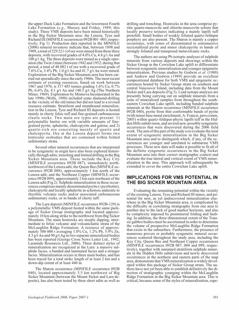
REFERENCES
An drew, A. and Godwin, C.I. (1989): Lead- and stron tium-iso topegeo chem is try of Pa leo zoic Sicker Group and Ju ras sic Bo -nanza Group vol ca nic rocks and Is land in tru sions, Van cou -ver Is land, Brit ish Co lum bia; Ca na dian Jour nal of EarthSci ences, vol ume 26, pages 894–907.
Barrett, T.J. and Sherlock, R.L. (1996): Vol ca nic stra tig ra phy,lithogeochemistry and seafloor set ting of the H-W mas sivesul fide de posit, Myra Falls, Van cou ver Is land, Brit ish Co -lum bia; Ex plo ra tion and Min ing Ge ol ogy, vol ume 5, pages421–458.
Brandon, M.T., Or chard, M.J., Parrish, R.R., Suther land Brown,A. and Yorath, C.J. (1986): Fos sil ages and iso to pic datesfrom the Pa leo zoic Sicker Group and as so ci ated in tru siverocks, Van cou ver Is land, Brit ish Co lum bia; in Cur rent Re -search, Part A, Geo log i cal Sur vey of Can ada, Pa per 86-1A,pages 683–696.
Frank lin, J.M., Gib son, H.L., Jonasson, I.R. and Gal ley, A.G.(2005): Volcanogenic mas sive sul phide de pos its; in Eco -nomic Ge ol ogy 100th An ni ver sary Vol ume, Hedenquist,J.W., Thomp son, J.F.H., Goldfarb, R.J. and Rich ards, J.P.,Ed i tors, Eco nomic Ge ol ogy, pages 523–560.
George Cross News Let ter Ltd. (1992): [ti tle un known]; GeorgeCross News Let ter, num ber 188, Sep tem ber 29, 1992.
Godwin, C.I., Gabites, J.E. and An drew, A. (1988): Leadtable: aga lena lead iso tope da ta base for the Ca na dian Cor dil lera;
BC Min is try of En ergy, Mines and Pe tro leum Re sources, Pa -per 1988-4, 214 pages.
Juras, S.J. (1987): Ge ol ogy of the polymetallic volcanogenicButtle Lake Camp, with em pha sis on the Price Hill side, cen -tral Van cou ver Is land, Brit ish Co lum bia, Can ada; un pub -lished PhD the sis, Uni ver sity of Brit ish Co lum bia,Van cou ver, BC, 279 pages.
Katvala, E.C. (2006): Re ex am in ing the strati graphic andpaleontologic def i ni tion of Wrangellia; Geo log i cal So ci etyof Amer ica, Ab stracts with Pro gram, vol ume 38, page 24.
Lara mide Re sources Ltd. (2006): Lara Pro ject: Van cou ver Is land,Brit ish Co lum bia; Lara mide Re sources Ltd., pro ject de -scrip tion, URL <http://www.lara mide.com/proj_lara.html>[No vem ber 2006].
Massey, N.W.D. (1995a): Ge ol ogy and min eral re sources of theDuncan sheet, Van cou ver Is land, 92B/13; BC Min is try ofEn ergy, Mines and Pe tro leum Re sources, Pa per 1992-4.
Massey, N.W.D. (1995b): Ge ol ogy and min eral re sources of theAlberni-Nanaimo Lakes sheet, Van cou ver Is land, 92F/1W,92F/2E and part of 92F/7E; BC Min is try of En ergy, Minesand Pe tro leum Re sources, Pa per 1992-2.
Massey, N.W.D. (1995c): Ge ol ogy and min eral re sources of theCowichan Lake sheet, Van cou ver Is land, 92C/16; BC Min is -try of En ergy, Mines and Pe tro leum Re sources, Pa per 1992-3.
Massey, N.W.D. and Fri day, S.J. (1987): Ge ol ogy of theChemainus River – Duncan area, Van cou ver Is land (92C/16, 92B/13); BC Min is try of En ergy, Mines and Pe tro leum Re -sources, Pa per 1988-1, pages 81–91.
Massey, N.W.D. and Fri day, S.J. (1989): Ge ol ogy of the Alberni-Nanaimo Lakes area, Van cou ver Is land (92F/1W, 92F/2Eand part of 92F/7); BC Min is try of En ergy, Mines and Pe tro -leum Re sources, Open File 1987-2.
MINFILE (2006): MINFILE BC min eral de pos its da ta base; BCMin is try of En ergy, Mines and Pe tro leum Re sources, URL<http://www.em.gov.bc.ca/Min ing/Geolsurv/Minfile/>[No vem ber 2006].
Mortensen, J.K. (2005): Strati graphic and paleotectonic studies ofthe Mid dle Pa leo zoic Sicker Group and contained VMSoccurrences, Van cou ver Is land, Brit ish Co lum bia; in Geo -log i cal Field work 2005, BC Min is try of En ergy, Mines andPe tro leum Re sources, Pa per 2006-1, pages 331–336.
Mul ler, J.E. (1977): Evo lu tion of the Pa cific mar gin, Van cou ver Is -land and ad ja cent re gions; Ca na dian Jour nal of Earth Sci -ences, vol ume 14, pages 2062–2085.
The North ern Miner Ltd. (1969): [ti tle un known]; The North ernMiner, Sep tem ber 25, 1969.
Parrish, R.R. and McNicoll, V.J. (1992): U-Pb age de ter mi na tionsfrom the south ern Van cou ver Is land area, Brit ish Co lum bia;in Ra dio genic Age and Iso to pic Stud ies: Re port 5, Geo log i -cal Sur vey of Can ada, Pa per 91-2, pages 79–86.
Pearce, J.A., Har ris, N.B.W. and Tindle, A.G. (1984): Trace el e -ment dis crim i na tion di a grams for the tec tonic in ter pre ta tionof gra nitic rocks; Jour nal of Pe trol ogy, vol ume 25, pages956–983.
Shervais, J. W. (1982): Ti-V plots and the petro gen esis of mod ernand ophiolitic lavas; Earth and Plan e tary Sci ence Let ters,vol ume 59, pages 101–118.
Sluggett, C.L. (2003): Ura nium-lead age and geo chem i cal con -straints on Pa leo zoic and Early Me so zoic magmatism inWrangellia Terrane, Saltspring Is land, Brit ish Co lum bia;un pub lished BSc the sis, Uni ver sity of Brit ish Co lum bia,Van cou ver, BC, 56 pages.
Sluggett, C.L. and Mortensen, J.K. (2003): U-Pb age and geo -chem i cal con straints on the paleotectonic evo lu tion of thePa leo zoic Sicker Group on Saltspring Is land, south west ernBrit ish Co lum bia; Geo log i cal As so ci a tion of Can ada – Min -
392 Geoscience BC, Re port 2007-1
er al og i cal As so ci a tion of Can ada, Joint An nual Meet ing,Pro gram with Ab stracts, vol ume 28.
Sun, S.S. and McDonough, W.F. (1989): Chem i cal and iso to picsys tem at ics of oce anic bas alts: im pli ca tions for man tle com -po si tion and pro cesses; in Magmatism in Ocean Bas ins,Saunders, A.D. and Norry, M.J., Ed i tors, Geo log i cal So ci ety of Lon don, pages 313–345.
Wells, G.S. (1990): Di a mond drill ing re port, Mount Sicker prop -erty; BC Min is try of En ergy, Mines and Pe tro leum Re -sources, As sess ment Re port 19754, 15 pages.
Winchester, J.A. and Floyd, P.A. (1977): Geo chem i cal dis crim i na -tion of dif fer ent magma se ries and their dif fer en ti a tion prod -ucts us ing im mo bile el e ments; Chem i cal Ge ol ogy, vol ume20, pages 325–343.
Yorath, C.J., Suther land Brown, A. and Massey, N.W.D. (1999):LITHOPROBE, south ern Van cou ver Is land, Brit ish Co lum -bia: ge ol ogy; Geo log i cal Sur vey of Can ada, Bul le tin 498,145 pages.
Geo log i cal Field work 2006, Pa per 2007-1 393

394 Geoscience BC, Re port 2007-1