Embed Size (px)
Citation preview
2.11249 BEARDY CREEK 010
GEOLOGICAL AND GEOCHEMICAL REPORT
ON THE
BIG TROUT LAKE PROPERTY
PATRICIA MINING DIVISION, ONTARIO
AUGUST - SEPTEMBER, 19B7
LATITUDE 53*40' NORTH
LONGITUDE B9'56' WEST
NTS 53-G/1E
ON BEHALF OF
697895 ONTARIO LTD.
TORONTO, ONTARIORECEIVED
MA\ ?, 7 1988
MINING LANDS SUiJN
CONTWOYTO GOLDFIELDS LIMITED 1BBO, 444 - 5TH AVENUE S.W. CALGARY, ALBERTA TBP ETB
J. GROOTENBOER, Ph. D. MAY 10, 19BB
fj 53H12NWe003 a.11249 BEARDY CREEK
TABLE DF CONTENTS
Page INTRODUCTION. . . . . . . . . . , . . . . . . . . .. . . . . . . . . , . . . . . . . . . . . . . . . . . . . l
Location and Access.. . .. . .... . . . . . . . . . . . . . . . . . . . . . . . . . . . lProperty Status . . . . . .. . .. . . . . . . . . . . . . . . . . . . . . . . . . . . . . . . . lPhysiography.. . . . , . . . . . . . . . . . . . . . . . . . . . . . . , . , . . . . . . . . . . . 2
PREVIOUS WORK. . . . . . . . . . . .. . . . . . . . , . . . . . . . . . . . . . . . . . . . . . . . . . . . E
REGI ONAL GEOLOGY. . . ... . . , .... .. ... . ... , . . . . . . . . .. . . . . . . . . . . . . 3
19B7 SUMMER EXPLORATION PROGRAM. . . . . . . . . . . . . . . . . . . . . . . . . . . . . . 4
GEOLOGICAL MAPPING. . . . . . . . . . . . . . . . . . . . . . . . . . . . . . . . . . . . . . . . . . . 5Mineralization.................... . ....... . .. . . . . . . . . . . . BStructure...,................. . . . . . . . . . . . . . . . . . . . . . . . . . . B
LITHOGEOCHEMISTRY. . . . . . . . . . . . . . . . . . . . . , . . . . . , . . . . . . . . . . . . . , . . B
CONCLUSIONS.. . . . . . . . . . . . . . . . . . . . . .. . . . . . . . . . . . ............... 7
RECOMMENDATIONS. . . . . . . . . . . . . . . . . . . . . . . , . . .. . . . . . . . . . . . . . . . . . . 8
CERTIFICATION. .. . . . . . . .. . . , . . . . . . . . . . . . . . . . . . . . . . . . . . . . . . . , . 9
REFERENCES................................................... 10
APPENDIX I Analytical ResultsII Analytical Techniques
III Summary of Personnel
AFFADAVIT
LIST DF FIGURESFollows Page
l Location Map..........................., . . . . . . l
B C laim flap. . . . . . . . . . . . . . , . . . . . . . . . . . . . . . , . . . . . . l
3 Regional Geology.......... .. . . . . . . . . . . . . . . . . . . 3
010C
LIST DF MAPS
Geology Along South Shore of Big Trout Lake, Ontario1:l,000 Back Pocket
INTRODUCTION
This report was prepared by Contwoyto Goldfields Limited on behalf of 697835 Ontario Ltd. of Toronto Ontario. Contwoyto carried out a program of geological mapping and rock chip sampling during the period August 31 to September 4, 19B7. The work was conducted by the author (See Appendix III).
The property is underlain by the eastern basal part of the Big Trout Lake Complex (BTLC). This layered mafic/ultramafic complex displays many affinities to the "Bushveld" type of stratiform intrusion that is the primary source of chromium and platinum group elements (PGE's) in the world. These affinities, together with reported significant PBE values in the BTLC, indicate that the BTLC exhibits moderate potential for hosting concentrations of PGE's.
Location and Access:
The Big Trout Lake property is situated in extreme northwestern Ontario, E50 km north of the village of Pickle Lake (Figure 1). The claims which were investigated are centered on 53*40' North latitude and 83*56' West longitude, within NTS map-sheet 53G-1E,
Access to the property from Pickle Lake is via float or ski equipped aircraft to Big Trout Lake or to several of the larger lakes on the property. Daily scheduled flights also connect Pickle Lake and Big Trout Lake. Access from the community of Big Trout Lake to Sioux Lookout is via a winter road. The 800 inhabitants of Big Trout Lake are serviced by a small general store and trading post.
Property Status:
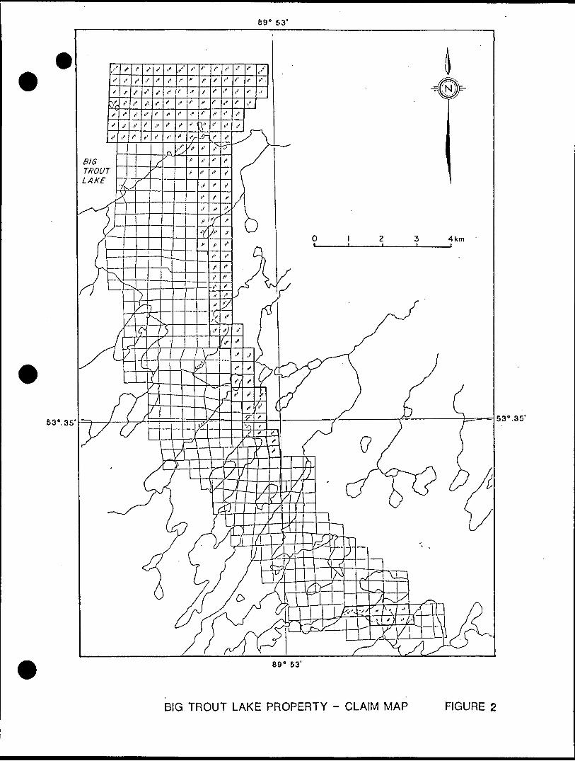
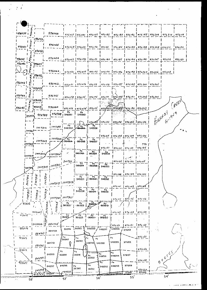
The hammer-shaped Big Trout Lake property comprises 163 claims totalling 6,753 acres. The property is located in the Patricia Mining Division. The claims are shown on Figure B and listed in Table 1.
The property is subject to a Joint venture agreement between Contwoyto Goldfields Limited, Calgary, Alberta, and 637835 Ontario Ltd., a wholly owned Canadian subsidiary of Greater Pacific Investments Ltd., Sydney, Australia.
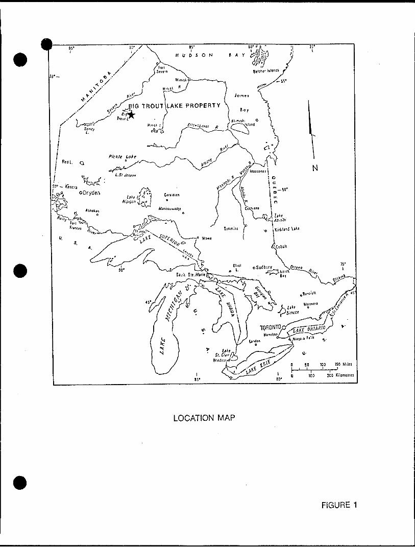
TROUT LAKE PROPERTY
LOCATION MAP
FIGURE 1
69" 53'
53', 35' 53 0 .35'
89" 53'
BIG TROUT LAKE PROPERTY - CLAIM MAP FIGURE 2
TABLE l - CLAIM STA1IST1CB
CI si t Numbers
Pa
Pa
Pa
Pa
Pa
976039-9760BO
976061-976116
976119-976160
976161-976164
976169-976213
Clam
42
36
42
4
J5
hap Area
Beardy Creek
Neseigusabins Lake
Beardy Creek
nemeigusabins Lake
Beardy Creek
Kecordinq
April
April
April
April
April
01,
01,
01,
01,
01,
Date
19B7
19B7
1987
1967
1987
Expiry Date
April
April
April
April
April
01,
01,
01,
01,
01,
19BB
196B
19BB
19BB
19BB
TOTAL: 169 Claiis
Physiography:
The property is characterized by almost flat relief. Topographical variations, mainly attributed to eskers and other surficial deposits, do not exceed 65 meters. Bedrock exposures represent less than l '/, of the total surface area and are almost exclusively confined to lake shores. Large areas of the property do not have any outcrop. Big Trout Lake covers the northern "hammer head" part of the property. The area is principally forested by relatively dispersed, small spruce trees.
PREVIOUS UIDRK
Tyrell (1313) carried out reconnaissance geological mapping in the Big Trout Lake area as part of the Hudson Bay exploring expedition of 191B. Hudec (1964) mapped the area at a scale of l inch ~ 2 miles. The geological map was modified by Sage and Troop (1974) during Operation Winnisk for the Ontario Geological Survey. Ulittacker (1980) studied the general nature of the peridotitic rocks belonging to the Big Trout Lake Complex (BTLC) and the geochemistry of the chromites in the ultramafic rocks. He reported a close association of sulphide grains with chromite and and the presence of net-textured sulphides in the peridotitic rocks. Borthwick and Naldrett (19E3E) investigated the geology and geochemistry of the Big Trout Lake Complex with particular emphasis on the PGE and chromite distribution. Borthwick (19BB) reported on the geology and geochemistry of the BTLC.
Minor exploration activity in the early part of the century was focused on gold showings in the greenstone belt. In the 1970's, Canadian Nickel Company (Inco Ltd.) apparently flew an electromagnetic survey over the area. The results of this survey were not filed for assessment credit. Inco subsequently drill tested (at least nine holes totalling 14,500 feet) the southern extension of of the layered intrusion and intersected peridotite containing chromitite seams. One series of holes, 10 km north of

Nemeigusabins Lake, was designed to evaluate the gross layering of the Big Trout Lake Complex. The chromium potential was evaluated (including beneficiation studies) but the prospect was considered uneconomic at that time.
In 19BO-B3, Canadian Occidental Petroleum Ltd. carried out an exploration program over Five grids covering parts of the Big Trout Lake Complex. An airborne magnetometer survey was mentioned in their report but was not Filed For assessment credit. One oF the grids (#4) was immediately to the west oF the southern part oF the Big Trout Lake property. Canadian Occidental Petroleum Ltd. Filed eight holes For assessment credit but show eleven holes on one oF their maps. Eight chromitite and chromite-rich layers were intersected. A considerable amount oF petrographic and analytical work was done on the core. Several hundred samples were analysed For PGE's.
The land portion oF the previously known ultramafic portion oF the Big Trout Lake Complex was acquired by International Platinum Corporation in 1985.
In late 1385, drilling outlined a 160-foot wide zone oF anomalous PBE values separate from the known chromite horizons (Postle et al, 1986). International Platinum Corporation has recently carried out an airborne and ground electromagnetic/magnetic survey over its property. The airborne survey was filed for assessment credit, but the information is not yet available, pending approval by the Ontario Department of Mines.
In its 19BB Annual Report, International Platinum Corporation reports a previously drilled intersection in the BTLC in which hole Bl-B returned O.EB ounces platinum group metals per ton over B.7 Feet. As well, International Platinum Corporation announced that the First hole oF its 19BB drill programme returned 0.15 ounces per ton platinum group metals over two Feet, with a ratio oF Pd:Pt oF E:l (Mining Journal, March, 19BB).
The property oF International Platinum Corporation adjoins to the south and west, the main claim block in the area under option by Contwoyto SoldFields Limited.
REBIDNAL BEDLDGY
The Big Trout Lake property is located within the Sachigo River greenstone belt (Figure 3). This east-west trending belt is one oF the many that comprise the Archean Superior Province oF the Canadian Shield.
Metavolcanic and metasedimentary rocks are the oldest rocks oF the greenstone belt. The metavolcanic rocks are predominantly maFic to intermediate in composition. The metasedimentary rocks are mainly volcaniclastic in nature while paragneisses oF unknown origin ere common in the Severn Lake area.
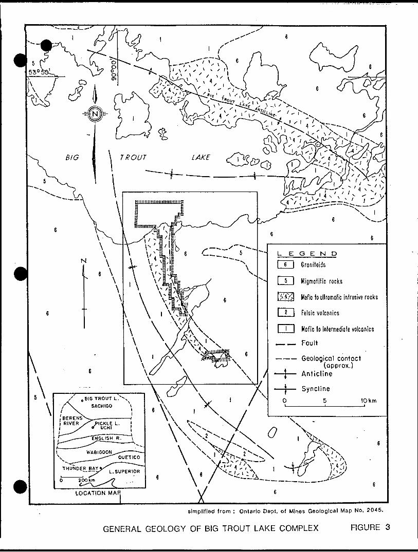
Granitoids
Migmatitic rocks
Mofic to ultromofic intrusive rocks
Felsic volcanics
Mafic to intermediate volcanics
Fault
Geological contact. (approx.)
Anticline
simplified from : Ontario Dept. of Mines Geological Map No. 2045.
GENERAL GEOLOGY OF BIG TROUT LAKE COMPLEX FIGURE 3
The Big Trout Lake Complex (BTLC) intrudes the supracrustal rocks as a sill near the contact between the metavolcanic and metasedimentary rocks. This complex forms a SO km long Z-shaped body along the northern and southern shores of the eastern part of Big Trout Lake. The BTLC is predominantly anorthositic in composition but displays gabbroic and ultramafic phases. A basal unit of chromite-rich peridotite and dunite is overlain by anorthosite, olivine gabbro, gabbro (including a distinctive cumulate unit), and quartz-bearing gabbro. Geophysical evidence suggests that the ultramafic rocks are restricted to the southern limb of the Complex. Banding and cumulate textures have been interpreted by Hudec (1964) as evidence for very slow cooling and fractionation within a large magma chamber.
During the Kenoran Orogeny, the supracrustal rocks and the BTLC were intruded by large granitic batholiths, subjected to several phases of deformation, and regionally metamorphosed to the upper greenschist or lower amphibolite facies.
19B7 SUMMER EXPLORATION PROGRAM
Detailed geological mapping and lithogeochemical sampling were carried out along a single traverse along the south shore of Big Trout Lake. Excellent outcrops represent a cross section of the lower ultramafic/mafic portion of the Big Trout Lake Complex. Several units of ultramafic peridotite and pyroxenite (occasionally pyrite and chalcopyrite bearing) were found to outcrop within the staked area and appear to represent favourable host rock environments for Platinum Group Element (PGE) mineralization.
Only a few representative hand specimens of peridotite and pyroxenite were collected owing to the limited time available and to the dangerous conditions prevailing along certain stretches of the shore-line at the time the work was conducted.
Operations at Big Trout Lake were conducted from the Indian village of the same name where accommodation was provided in a cabin of the Band Office. The Band Office also assisted in hiring an Indian guide and boat for crossing the lake. Owing to unstable weather conditions prevailing in September, the crossing proved difficult and dangerous. It was nevertheless possible to carry out work along the south shore during four days. The limited amount of time available led to only the most critical work (geological mapping, rock chip sampling) being carried out. It also proved to be impossible to investigate the small islands within the claim area. Outcrop conditions along many sections of the south shore are excellent, but conditions are frequently dangerous when the wind is from the north. Some areas could only be investigated superficially and it proved to be especially difficult to obtain petrologicel hand specimens. The area inland from the immediate shore is covered by thick glacial overburden and no outcrops appear to be present at all.
GEOLOGICAL HAPPING:
A E km long stretch of the southern shore of Big Trout Lake was mapped by hipchain and compass at a scale of 1:10,000. The field observations have been compiled onto an uncontrolled map at 1:1,000 scale (Map 1). Isolated outcrops of granite protrude through the beach sand in the eastern extremity of the claim area. The Footwall contact of the Big Trout Lake Complex was not observed in the Field, but lies within a 100 meter wide area devoid oF outcrop.
The lowermost exposed rocks oF the Complex consist oF pitted olivine-bearing peridotites. The peridotites outcrop along the shore over a distance oF 160 meters. The rocks are severely disturbed by UJNW-trending Faults and dykes. Their true stratigraphic thickness is diFFicult to estimate, but could be anywhere From SO to 100 metres. It is thus possible that up to 200 metres stratigraphic thickness oF ultramaFic rocks may be present in the claim area. The peridotites are interbedded with, and Faulted against, rocks oF generally gabbroic composition. Towards the west these gabbros grade into very coarse-grained anorthosites (potato anorthosite).
The central portion oF the area mapped consists oF relatively thinly interbedded anorthosites, pyroxenites, and gabbros. These rocks are all coarse grained and in many cases pegmatitic. Feldspar crystals in the potato anorthosite are Frequently 10-BO cm in diameter, and pyroxenes oF 5-10 cm are not uncommon. A characteristic pegmatitic pyroxenite contains magnetite crystals up to 5 cm in diameter and gives rise to very strong magnetic anomalies. All rocks strike north-south, dips are vertical to steeply to the west, and compositional layering indicates that the stratigraphic top is to the west. Several UNW-trending dykes and Faults are present, oFten showing evidence oF reactivation, as well as intrusion oF late-stage anorthosite. Other similar Faults, dykes and shear zones are inFerred to be present in several areas lacking in outcrop.
The western portion oF the traverse is underlain predominantly by anorthosite, Frequently "potato" anorthosite, interbedded with pyroxenites oF a Few metres thick. Two units oF pegmatitic magnetite-rich pyroxenite are present and are again strongly magnetic. Another magnetic anomaly is associated with a 3 metre wide unit oF pyrite and chalcopyrite-rich pyroxenite CStn 90). A Few thin dess than 3 metres wide) sulphide-bearing peridotites also occur interlayered with pyroxenites. The western portion oF the shore line runs NE to SU), perpendicular to the dominant direction oF Faulting, and numerous Faults and dykes can be observed. The predominant Fault direction is WNU), but several north-south Faults are also present. The rocks generally strike northerly, and dip to the west at 70-85*. Compositional layering suggests the stratigraphic top to be to the west.
Mineralization:
Both pyrite and chalcopyrite were found to be present in minor quantities in most outcrops examined. No chromite was noted, but it is unlikely that minor quantities of chromite, if present, would have been distinguished from the magnetite which is often present.
Significant mineralization was observed only at the following stations (flap 1):
Station SB: Irregular lenses of pyrite and chalcopyrite-bearing pyroxenite occur in anorthosite over a width of E metres.
Station 81: Disseminated sulphides in E metre wide,massive peridotite interlayered with pyroxenites.
Station 90: Zone (3 m wide) of complexly intermixed,sulphide - rich pyroxenite, pegmatitic gabbro, and pegmatitic anorthosite.
Structure:
The layered rocks of the Big Trout Lake Complex generally strike north-south and dip steeply to the west. Uest-northwest-trending faults, dykes and shear zones are prominent, though the displacement on many of these seems to be minor. There is considerable evidence for reactivation of such faults and shears. Discontinuities in outcrops suggest the presence of north-south trending faults, but none could be seen in the outcrop. It is very likely that many of the discontinuities in outcrop along the lakeshore mark the position of further faults and/or shear zones.
LITHDBEDCHEtllSTRYA total of SE representative rock chip samples were collected, with emphasis on the sampling of all peridotite and pyroxenites as well as all sulphide-bearing outcrops. Samples were collected over stratigraphic widths of two metres or less. All samples were shipped to the Ottawa laboratories of Bonder Clegg for sample preparation and analysis for Pt, Pd, Au, Cu, Ni, and Cr.
The analytical results are given in Appendix I and the analytical techniques are given in II. Sample locations are shown on flap 1.
Sample values have been categorized in the following manner:
METAL
Pd
Pt
Cr
Ni
Cu
Au
Cppb)
Cppb)
(ppm)
(ppm)
(ppm)
(ppb)
RANGE
< E
B7
IB
B
4
to B
^5
to E7S
to 116
to 858
to 40
BACK GROUND
< E
OS
50
30
70
E
QUANTITY ABOVE ANOMALOUS
BACKGROUND VALUES > QUANTITY
3 0
0 0
170 7
98 5
EDO IE
11 1
Only three samples returned values above background for PGE's (A-B70E3, A-870E8, A-B7040). Sample AB7040 CB ppb Pd) was also anomalous in Ni (104 ppm).
Four samples CA-87004, A-B7006, A-B7011, A-87015) contained both anomalous Cr and Ni values.
Three samples CA-B701B, A-B70B1, A-870B5) contain anomalous Cu, with above background Au or anomalous Au.
A preliminary evaluation of lithogeochemistry results suggests, From east to west, weak zonation anomalies of Cu-Au, PGE's, and Ni-Cr.
CONCLUSIONS
Ultramafic peridotites and pyroxenites outcrop within the claims under option to Contwoyto Goldfields Limited.
Peridotites are most common near the eastern (basal) contact of the Big Trout Lake Complex and ultramafic rocks with a thickness of up to EDO metres may be present in this area on the property. Detailed ground magnetic surveys should be able to distinguish the peridot!tes from the granites to the east.
In the western half of the area mapped, four separate zones of pyroxenite occur, each of which contains pegmatitic magnetite- bearing pyroxenite layers. Peridotites may be associated with some of these pyroxenite units and were found to outcrop at one locality. Three of the four pyroxenite zones correspond to anomalous or above background values of Cr-Ni, PGE's, and Cu-Au.
Pyrite and chalcopyrite are present in significant quantities at several localities associated with pyroxenite end peridotite,
The presence of peridotites and pyroxenites near the base of the Big Trout Lake Complex suggests good potential for PEE mineralization similar to that located by previous drilling in the area.
RECOMMENDATIONS
It is recommended that the area be explored for PBE mineralization on a systematic basis. The exploration programme should encompass the following elements:
(1) Petrographic analysis of hand specimens collected to date.
(E) Further petrographic sampling.
(3) Compilation of geophysical and borehole data from exploration activities to the south with the view to establishing a relationship between mineralized intersections and magnetic signatures.
(4) Detailed magnetic survey of the area held under claim. An accuracy of E gamma is desirable to distinguish the peridotite granite contact. The survey would aid in tracing lithologies south from the lakeshore, indicate major faults and shears, and provide magnetic data to compare with that compiled under 3) above.
C5) Drilling:
a) If targets cannot be accurately defined, a programme of systematic stratigraphic drilling of peridotite and pyroxenite sequences is recommended.
b) Specific drilling targets should be outlined on the basis of similarities to magnetic data and borehole intersections from exploration activities to the south.
B
CERTIFICATION
I, Jan Grootenboer, of Proveniersplein la, 3033 EA Rotterdam, TheNether] ancls, do hereby certify that:
CI) l obtained a Ph.D. in geology/geochemistry in 1370 From tloilaster University, Hamilton, Ontario, and have practised my profession continuously since graduation.
CEO I have twEinty-three years experience in mineral exploration around the; world and have been employed by major British, South African, and Canadian mining companies.
C3) l have five years experience in platinum exploration, including four yeeirs of experience in exploration for primary platinum deposits of the Bushveld type.
C4) I am the; author of the report entitled "Geological and Beochemical Report on the Big Trout Lake Property, Patricia Mining Division, Ontario, August - September, 13EJ7".
Cb) I am a consulting geologist with offices located in Rotter-dam, The Netherlands.
(CO l do not own nor do l expect to receive any interest (direct or indirect or contingent) in the property described herein, nor- in the securities of Contwoyto Goldfields Limited.
Dated at Rotterdam, this 10th day of May, 1387.
J. Grootenboer, Ph.D.
REFERENCES
Borthwick, A.A.; Naldrett, A.J. (198E): Brant 106 Platinum Group Elements in the Layered Intrusions at Big Trout Lake; Ontario Beological Survey, Miscellaneous Paper 103.
_______ (1986): Platinum Group Elements in Layered Intrusions: The Geology and Geochemistry of the Big Trout Lake Layered Intrusion; Ontario Geological Survey, Open File 55B4.
Hudec, P.P. (1964): Geology of the Big Trout Lake Area, District of Kenora (Patricia Portion); Ontario Department of Mines, Geol Report No. E3.
International Platinum Corporation: 1986 Year-End Report.
Mining Journal, March E5, 1988, London, England, Vol. 310, p. E40.
Ontario Department of Mines: Assessment Files.
Postle,J.T.; et al C19BB): Review of Platinum Group Element Deposits in Ontario: Ontario Ministry Northern Development S Mines; Mineral Policy Background Paper No. E4.
Sage, R.P.; Troop, W.R. (1974): Operation Uinnisk Lake, Big Trout sheet, District of Kenora (Patricia portion); Ontario Dept. Mines, Preliminary Map PBBO.
Tyrell, J.B. (1913): Hudson Bay exploring expedition of 191E; Ontario Bureau of Mines, Vol. XXII, pt. 1.
LUittacker, P. J. (19BO); Chromite Deposits of Ontario; Ont. Beol. Survey, Open File 530B.
10
A F* F* E M D IX I
A, M t* L . V X I C f\ I~ R E S L J L. 'J'S
i* Zlli Ci
Oui.a, Canada K l
053-32
^•^
fi
',-r;;i-j;•' v-'' : '' . ",.
3-:
;-:-v. •- '
We, 7^"^2r/x
F,'
C-'
c•V
(H-
i; V-
"f': r -J *, . i •. - t
c-f]-
C
BONDAR- CLEGG
J .- ?' : y .v- -':. y : : : '::: ; ^ : : :1 -. - ' - .f. ' -\. ;' -r -' -
1 . - -. - .- . : ,- l r ' , . -.-.
1 - - -" -.. ' ' f- i
O' v"/ ' ' ^
"' -
' :
:: -c -li :-' -~.
541(1 Canclck kcl., Oiiaua,.Oni Canada kl| I'ho.ic: (6ll Iflcv. OSJ-JJTT
BONDAR- CLEGG Geochemical Lab Report
,K, r i- ft ut-
C y
IX II
METHODS
APPENDIX II
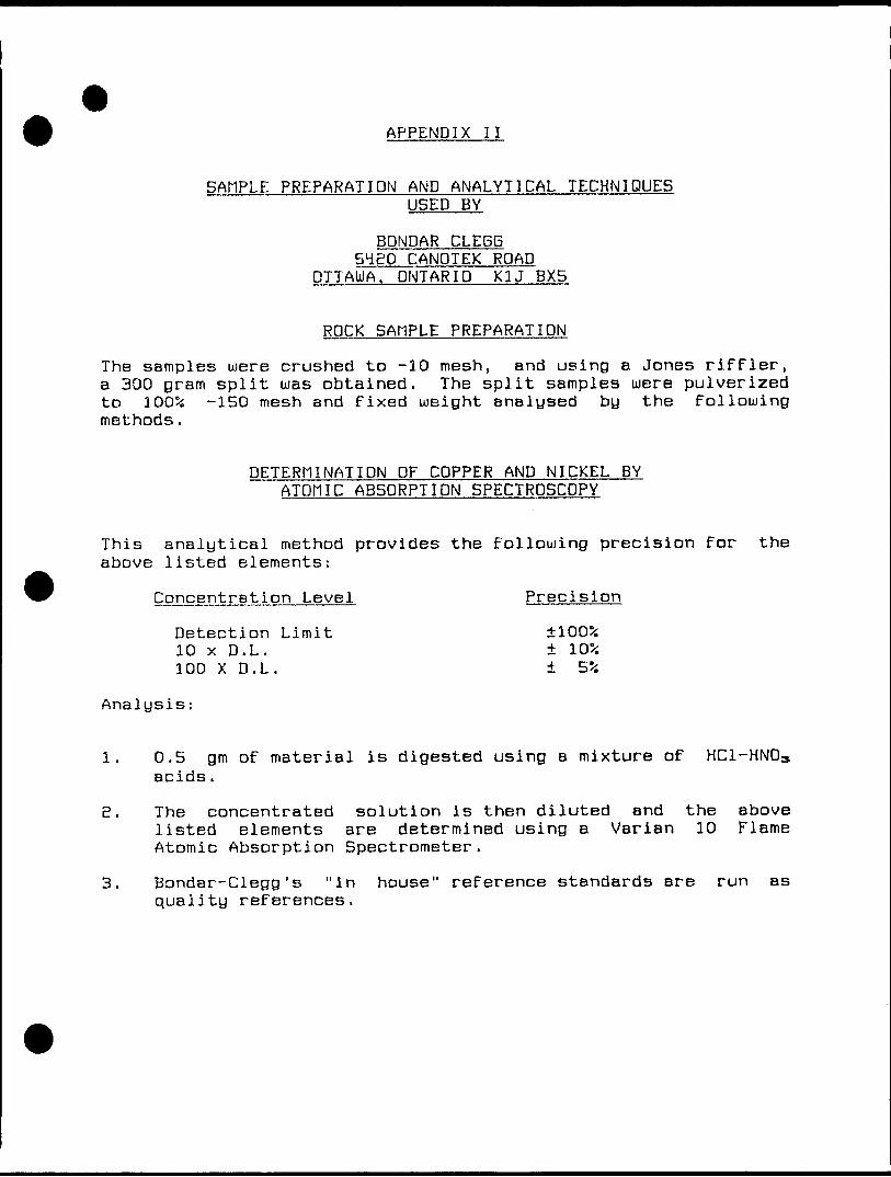
SAMPLE PREPARATION AND ANALYTICAL TECHNIQUESUSED BY
BDNDAR CLE6B 5480 CANDTEK ROAD
DTTAUIA. ONTARIO K3J BX5
ROCK SAMPLE PREPARATION
The samples were crushed to -10 mesh, and using a Jones riffler, a 300 gram split was obtained. The split samples were pulverized to 1005i -150 mesh and fixed weight analysed by the following methods.
DETERMINATION DF COPPER AND NICKEL BY ATOM IC ABSDRPTION SPECTROSCOPY
This analytical method provides the following precision for the above listed elements:
Concentration Level Precision
Detection Limit 1005;10 x D.L. 10?i100 X D. L. 5?i
Analysis:
1. 0.5 gm of material is digested using a mixture of HC1-HN03 acids.
E. The concentrated solution is then diluted end the above listed elements are determined using a Varian 10 Flame Atomic Absorption Spectrometer.
3. Bondar-Clegg's "in house" reference standards are run as quality references.
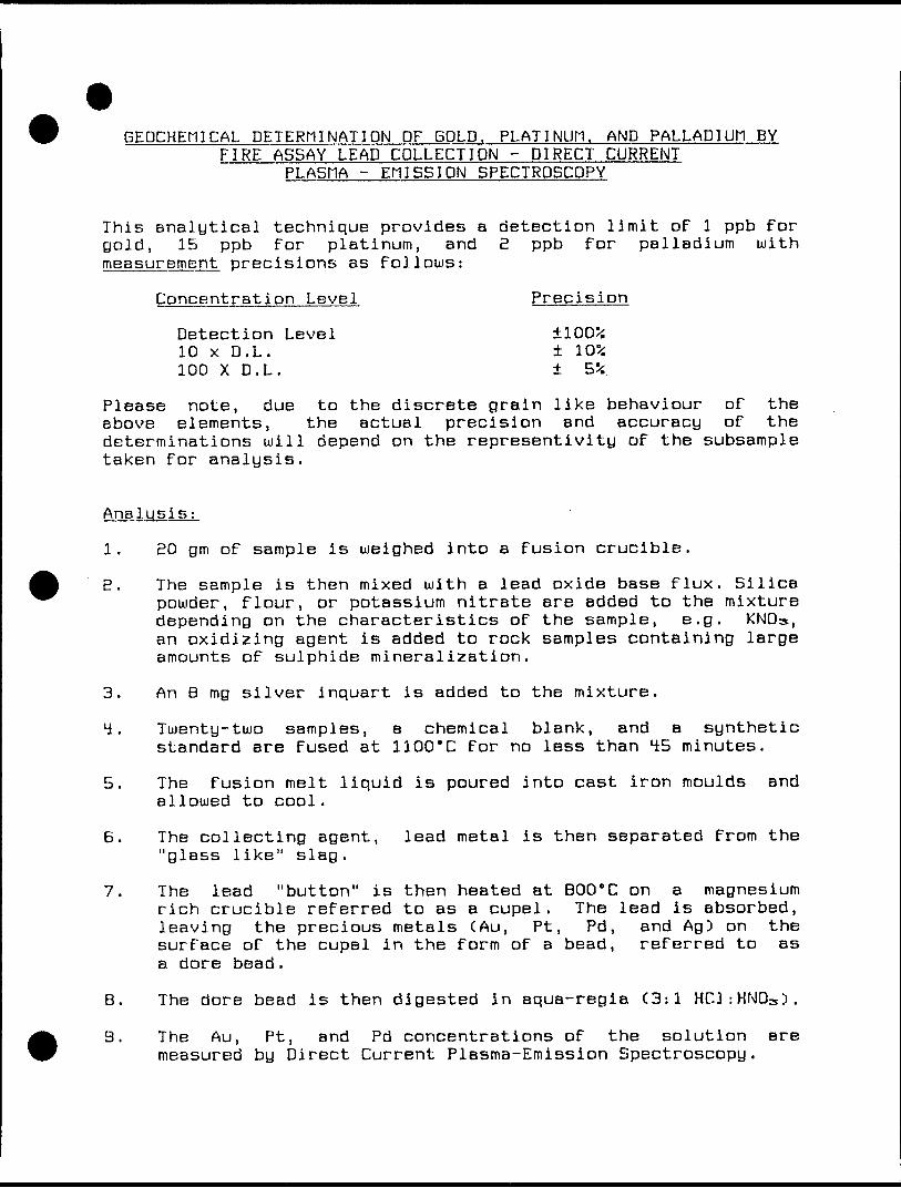
GEDCHEtllCAL DETERMINATION DF GOLD. PLATINUM. AND PALLADIUM BY FIRE ASSAY LEAD COLLECTION - DIRECT CURRENT
PLASMA - EMISSION SPECTRDSCDPY
This analytical technique provides a detection limit of l ppb For gold, 15 ppb for platinum, and 2 ppb For palladium with measurement precisions as Follows:
Concentration Level Precision
Detection Level 100^10 x D.L. 10*100 X D. L. 5*.
Please note, due to the discrete grain like behaviour oF the above elements, the actual precision and accuracy oF the determinations will depend on the representivity oF the subsample taken For analysis.
Analysis;
1. BO gm oF sample is weighed into a Fusion crucible.
S. The sample is then mixed with a lead oxide base Flux. Silica powder, Flour, or potassium nitrate are added to the mixture depending on the characteristics oF the sample, e.g. KNOs, an oxidizing agent is added to rock samples containing large amounts oF sulphide mineralization.
3. An B mg silver inquart is added to the mixture.
4. Twenty-two samples, a chemical blank, and a synthetic standard are Fused at 1100'C For no less than 45 minutes.
5. The Fusion melt liquid is poured into cast iron moulds and allowed to cool.
B. The collecting agent, lead metal is then separated From the "glass like" slag.
7. The lead "button" is then heated at BOO'C on a magnesium rich crucible reFerred to as a cupel. The lead is absorbed, leaving the precious metals CAu, Pt, Pd, and Ag) on the surFace oF the cupel in the Form oF a bead, reFerred to as a dore bead.
B. The dore bead is then digested in aqua-regia C3:l HC1:HND3 ).
3. The Au, Pt, and Pd concentrations oF the solution are measured by Direct Current Plasma-Emission Spectroscopy.
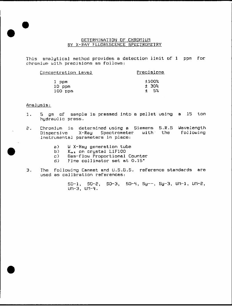
DETERMINATION DF CHROMIUM BY X-RAY FLUORESCENCE SPECTROMETRY
This analytical method provides a detection limit of l ppm for chromium with precisions as follows:
Concentration Level Precisions
l ppm 1005i10 ppm 30*100 ppm S*
Analysis:
l. 5 gm of sample is pressed into a pellet using a 15 ton hydraulic press.
B. Chromium is determined using a Siemens S.R.S Wavelength Dispersive X-Ray Spectrometer with the following instrumental parameters in place:
a) UJ X-Ray generation tubeb) KO.I on crystal LiFlOOc3 Gas-flow Proportional Counterd) Fine collimator set at 0.15*
3. The following Canmet and L).S.G.S. reference standards are used as calibration references:
SD-1, SD-S, SO-3, SO-4, Sy , Sy-3, UM-1, Ufl-E, LJH-3, UM-4.
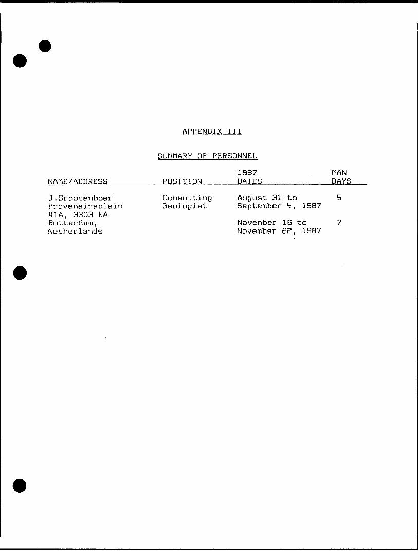
APPENDIX III
SUMMARY DF PERSONNEL
19B7 MANNAtlE/ADDRESS__________POSITION————DATES____________DAYS
J.Grootenboer Consulting August 31 to 5 Proveneirsplein Geologist September 4, 1987 ttlA, 3303 EARotterdam, November 16 to 7 Netherlands November E2, 19B7
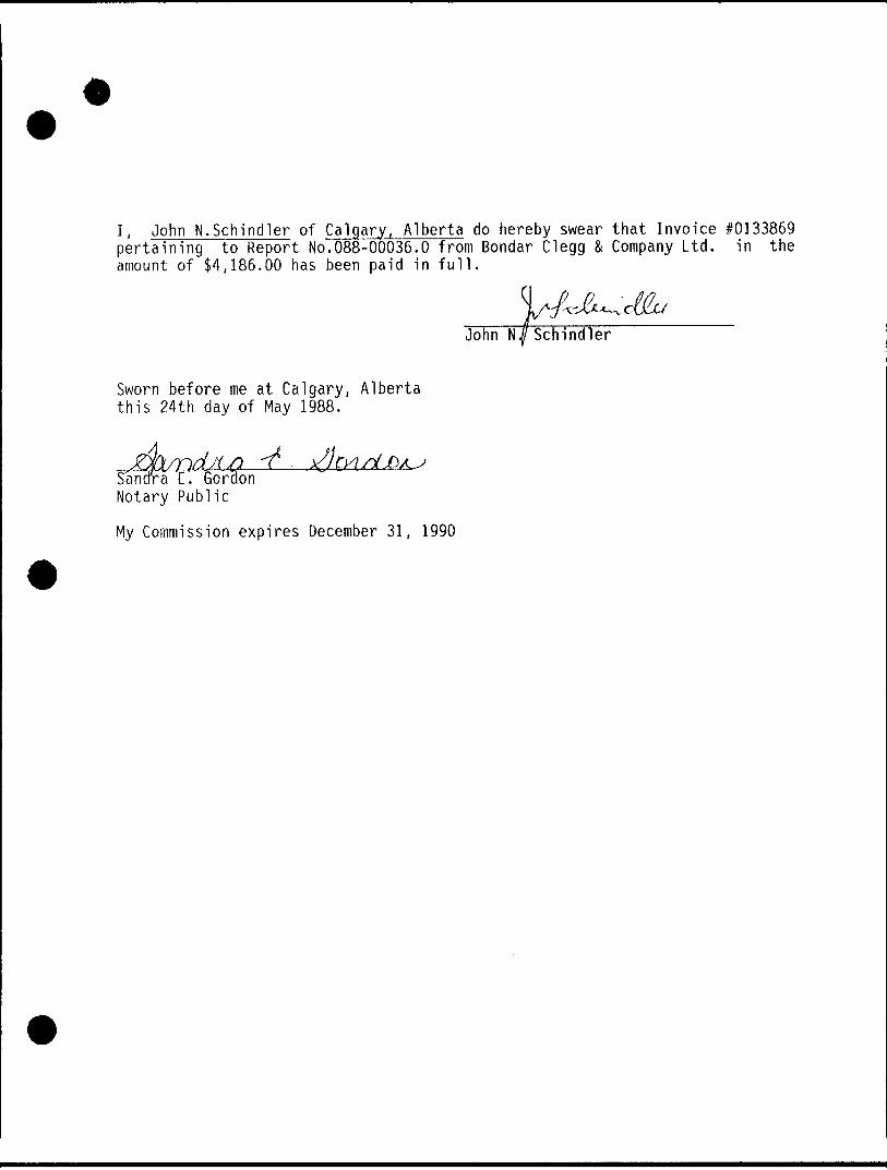
I, John N.Schlndler of Calgary, Alberta do hereby swear that Invoice #0133869 pertaining to Report No.088-00036.O from Bondar Clegg 81 Company Ltd. in the amount of S4,186.00 has been paid in full.
V.John N JI Schindler
Sworn before me at Calgary, Alberta this 24th day of May 1988.
,.Santfra 'E'. Gordon Notary Public
My Commission expires December 31, 1990
'Ministry of ' Northern Development
and Mines Ontario \t
A?irS"j4B*rSa±
Report of Work
{Geophysical, Geological,Geochemical and Expenditures)
DOC
WE
Type of SurveyTs)
Geological, Geochemical'cTaTm'H'oTdTrTs')" "" -.———
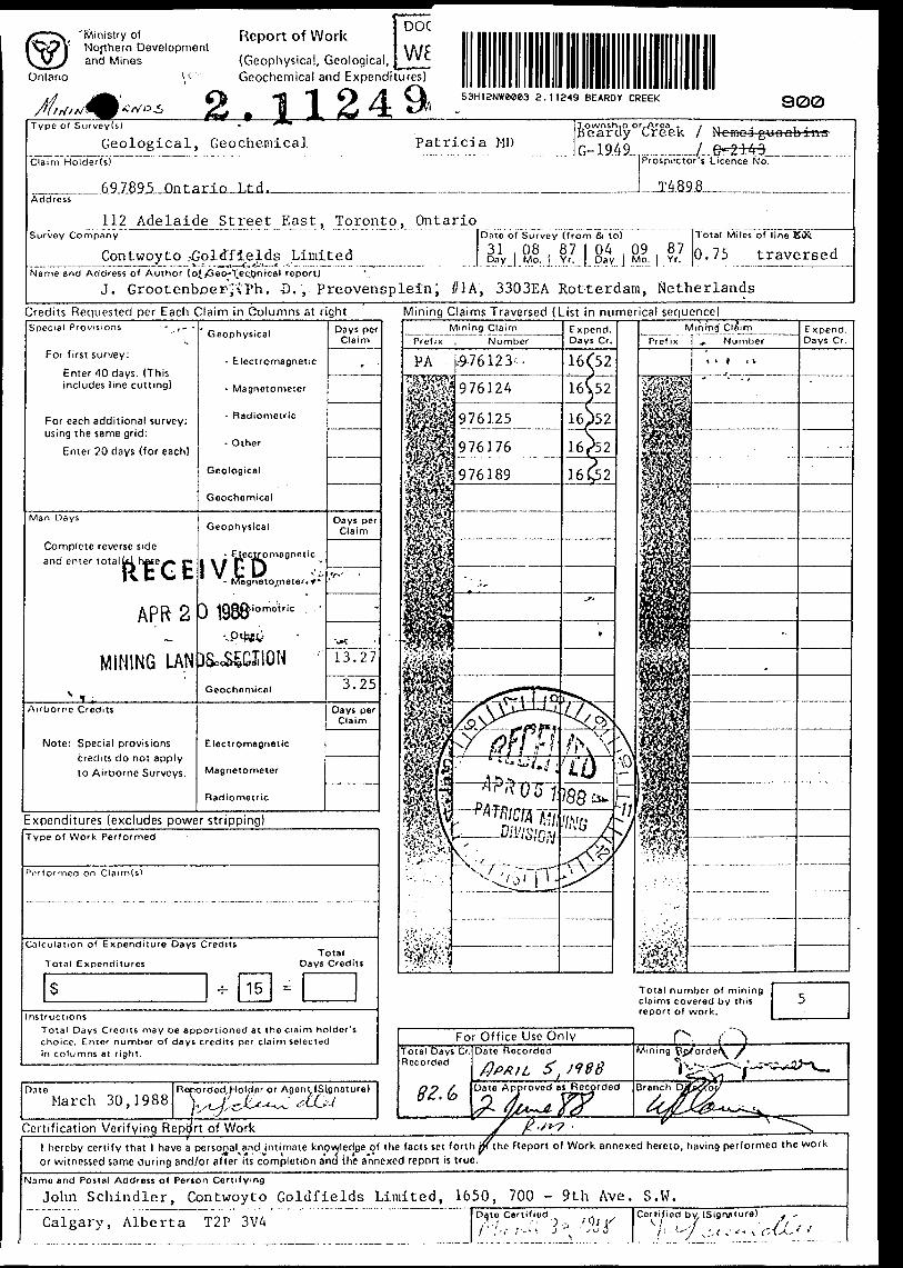
53H12NWe*e3 2.11249 BEARDY CREEK 900
Patricia MDTownship or,Area . , ., , , .Beardy Creek l N omoigUDQbi-ns G-194 9....-.. —-7. ..6=2*49-— —.-
Prospuctor's Licence No.
Address
Survey CompanyAdelaide Street East, Toronto, Ontario
Contwoyto -Goldfields Limited———————————————-L.....— s.-i---.^-^t,*Ln-.': ...--...... —....- .
Date of Survey (from Si to)
31 .08 , 87 l 04 .09 87Day J Mo. J Yr.^J Day | Mo. ) Yr.
Total Miles of line KX
0.75 traversedName and Address of Author (oi/Geo^ec.tjntcal report)
J. Grootenboer-,'x Ph. -D. , Preovensplein; //1A, 3303EA Rotterdam, NetherlandsCredits Requested per Each Claim in Columns at rightSpecial Provisions - ,- -
For first survey:
Enter 40 days. (This includes line cutting)
For each additional survey: using the same grid:
Enter 20 days (for each)
Man Days
Complete reverse side and enter total Ulhecex* P*
lit Vi t
APR 2
MINING LANv , ,
Airborne Credits
Note: Special provisions credits do not apply to Airborne Surveys.
Geophysical
- Electromagnetic
- Magnetometer
- Radiometric
- Other
Geological
Geochemical
Geophysical
- Electromagnetic
- Magneto/Tteter*.^*
D lQWXiomotric IvW
vptfcV
[)SecSgCI!ON
Geochemical
Electromagnetic
Magnetometer
Radiometric
Days per Claim
* '
Days perClaim
rf**
-
•^c .
13.27
3.25
Oays per Claim
Expenditures (excludes power stripping)Type of Work Performed
on Claim(s)
Calculation of Expenditure Days Credits
Total ExpendituresTotal
Days Credits
nstructionsTotal Days Credits may be apportioned at the claim holder's choice. Enter number of days credits por claim selected in columns at right.
D.i t eMarch 30,1988
Certification Verifying Report of Work
Mining Claims Traversed (List in numerical sequence)
976124
976125
976176
Total number of mining claims covered by this report of work.
Date Approved B S R ecorded
l hereby certify that l have a personal^and intimate knowledge of the facts set forth jp( t he Report of Work annexed hereto, having performed or witnessed same during and/or after its completion and the annexed report is true.
the work
Name and Postal Address of Person Certifying
John Schindler, Contwoyto Goldfields Limited, 1650, 700 - 9th Ave. S.W.
Calgary, Alberta T2P 3VA Date Certifiod•' p Certified by, (Sigr\ature)tifl
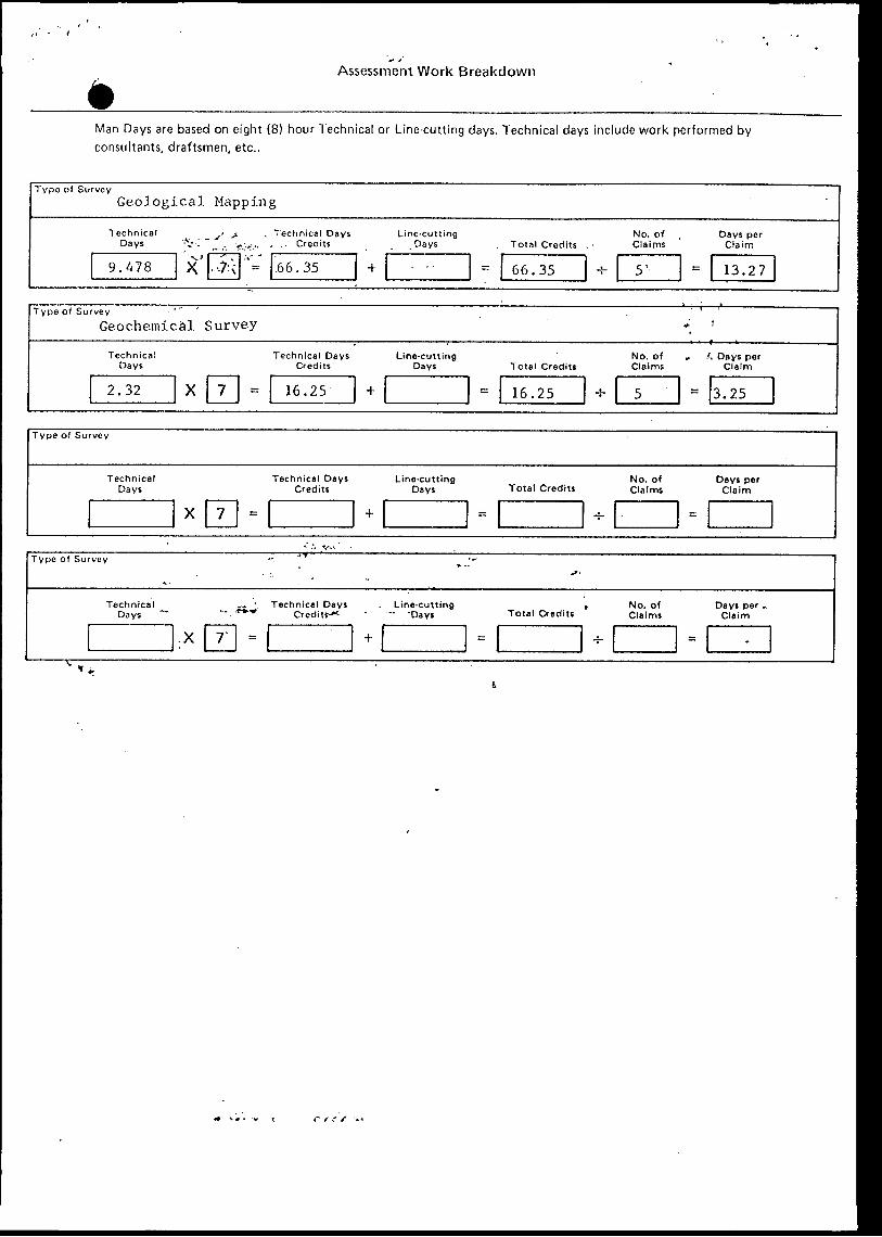
Assessment Work Breakdown
Man Days are based on eight (8) hour Technical or Line-cutting days. Technical days include work performed by consultants, draftsmen, etc..
Type of SurveyGeological Mapping
Technical y Days -Vi "^
9.478 X -0
f . Technical Days Line-cutting r^... , .- Credits . Days
'*i"~ .66.35 +
No. of Total Credits Claims
-- 6 6.35 -t- 5 '
Days per Claim
-- 1 3.27
Type of Survey ' " 'Geochemical Survey *
Technical Days
2.32 X 7 --
Technical Days Line-cutting Credits Days
16.25 *
No. of Total Credits Claims
16.25 4- 5
'* Days per Claim
: 3.25
^. : Technical Days . Line-cutting
/•Ministry of .Northern Development and Mines
Ontario
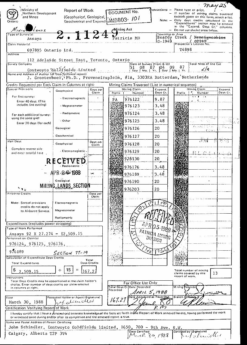
Report of Work H^Sr{Geophysical, Geological, J. Geochemical and "
M,1 H I lining Act
nstfuctions: — Please type or prijn.— If number of mining claims traversed
exceeds space on this form, attach a list. Note: — Only days credits calculated in the
"Expenditures" section may be entered in the "Expend. Days Cr." columns.
— Do not use shaded areas below.Type of Survey(s) J?
Assays *** * ILZ* *SPatricia MDClaim Holder(s)
697895 Ontario Ltd.Address
112 Adelaide Street East, Toronto,Survey Company
j' fContwoyto ^Goldf ie-l-ds
Name and Address of Author (o~f 'Geo- TechnicalJ. Grootenboer j v Ph. D
-Limited
Ontario
Township or AreaBeardy Creek f N emciguoabins jG-1949 7 G21:43
Prospector's Licence No.
T4898
Date of Survey (from & t o) ITotal Miles of line Cut31 08 87 |04 09 87 , i
Day 1 Mo. 1 Yr. Day T Mo. l Yr. j H /Hreport) ,..Proveneirsplein, //1A, 3303EA Rotterdam, "Netherlands
Credits Requested per Each Claim in Columns at right-Spc-ctal Provisions -' '
For first survey:
Enter 40 days. (This includes line cutting)
For each additional survey: using the same grid:
Enter 20 days (for each)
Man Days
Complete reverse side and enter total(s) here .
R~ h
MININAirborne Credits
Note: Special provisions credits do not apply . to Airborne Surveys.
Geophysical
- Electromagnetic
- Magnetometer
- Radiometric
- Other
Geological
Geochemical
Geophysical
- Electromagnetic-.
ECHWD- Radiometric ~
PR- -a®* 1988Geological
3cWlK.,SECTIO
Electromagnetic
Magnetometer
Radiometric
Days perClaim
-
Days per Claim
~
•.x
ii —Days per
Claim
Expenditures (excludes power stripping)Type of Work Performed
Assays 92 X 27.274 ^ $2,509.15Pcrformod on Claim(s)
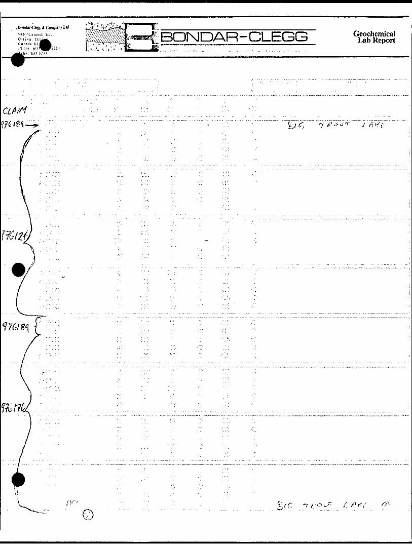
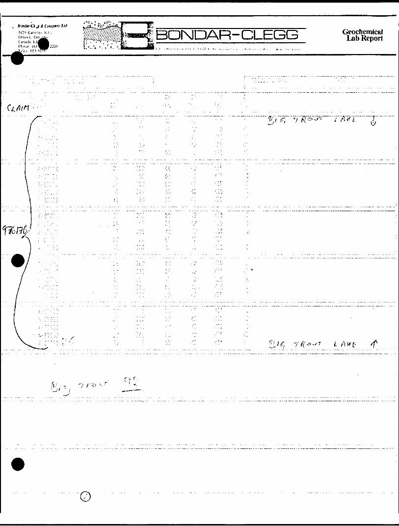
-?.Z6.12ii..,9 7.61.251 ..976176,
97*6189Calculation of Expenditure Days Credits
Total ExpendituresTotal
Days Credits
2.509.15nsiructions
Total Days Credits may bo apportioned at the claim h older's choice. Enter n umber of days c redits per claim selected in c olumns at r ight.
Dote
March 30, 1988Recofdcd Holder or Agont iSia"" tur fl*
/i
Mining Claims Traversed (List in numerical sequepce) t.Mining Claim
Prefix l N umberMining Claim
Prefix *, Number
Total n umber of mining claims c overed by this report of work.
Certification Verifying Repory of Workl hereby certify that l have a pfersonahand Intimate knowledgexif the facts set forth in vme R eport of Work annexed hereto, having performed the work or witnessed same during and/or after its completion and the annexed report is true.
N.imo and Postal Address of Person Certifying
John Schindler, Contwoyto Goldfields Limited, 1650, 700 - 9th Ave. S.W. Calgary, Alberta T2P 3V4 Date Certified
1 9^f/cd by (Signature) , .\ ,.-./ ^A^^-U-
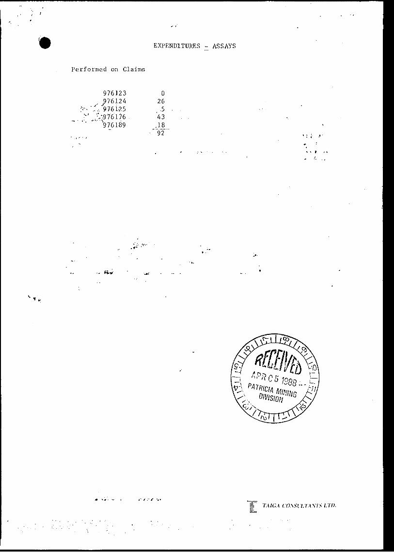
EXPENDITURES - ASSAYS
Performed on Claims
976123576124
:^ ~'',. "9.76 1-25"-\;'.-;976l76"' "" '976189
O 26
.5 43
.18 92
l i T.MCA CO\Sll.T.\MS LTD.
i i-
i-! -r-
j .-i- J
- --i-*
' ——
~-
——
—!,