Embed Size (px)
Citation preview
Maine Geological Survey Evidence of Ice Retreat, Sabattus Pond
Maine Geologic Facts and Localities November, 2002
Evidence of Ice Retreat, East Shore of Sabattus Pond
44° 7‘ 25.14“ N, 70° 5‘ 21.69“ W
Text by Michael E. Foley
Maine Geological Survey
Maine Geological Survey, Department of Agriculture, Conservation & Forestry 1

Maine Geological Survey Evidence of Ice Retreat, Sabattus Pond
Introduction
As you drive north along Pleasant Hill Road and Route 132 from Sabattus into the town of Wales, you come upon a set of distinctive glacial landscape features along the eastern shoreline of Sabattus Pond. Driving northward along this road you will follow the path of the melting ice sheet that once covered
Maine. Read ahead and get a better understanding, albeit brief, of the roadside surficial geology of the Sabattus Pond area, in the hope that it will pique your interest for further forays into Maine's fascinating glacial history. Much of this text is based on a paper by Retelle and Weddle (2001) from which this area
and landscape is described.
Maine Geological Survey, Department of Agriculture, Conservation & Forestry 2

Maine Geological Survey Evidence of Ice Retreat, Sabattus Pond
Location
Figure 1. Topography and location of glaciomarine deposits, Monmouth 7.5' quadrangle. Orange areas are glaciomarine deltas. Yellow are submarine outwash fans. Red lines are end moraines. Heavy blue line is marine shoreline during ice retreat. Dashed line is approximate position of ice margin when delta was deposited, now marking ice-contact slope.
Maine Geological Survey Aft
er R
etel
le a
nd
Wed
dle
, 20
01
Maine Geological Survey, Department of Agriculture, Conservation & Forestry 3
Maine Geological Survey Evidence of Ice Retreat, Sabattus Pond
Glacial History
The glacial deposits found on the east shore of Sabattus Pond are associated with the retreat of the last ice sheet which covered Maine, the late Wisconsinan age Laurentide Ice Sheet, which reached its maximum extent in New England around 25,000 years before present (Stone, 1995). This ice sheet extended well into the Gulf of Maine, and it began its recession northward around 17,000 yr B.P. (Smith and Hunter, 1989). The great weight of the ice sheet depressed the land surface, and as the glacier retreated, the ocean flooded inland, keeping contact with the ice margin. Sea level at the time of deglaciation in the Sabattus Pond area was approximately 330 feet above modern sea level (Thompson and others, 1989). The 330 foot flat-topped surface of the Pleasant Hill and Marr Point deltas approximates this high sea-level stand. As the ice retreated through the Monmouth quadrangle, all the present-day land below about 330 feet was completely submerged, while the areas above 330 feet were islands. The approximate shoreline at the time is shown on Figure 1. As the ice retreated, it did so in an erratic and non-uniform manner. In some instances, it retreated at a steady pace, and no deposition took place along the ice-margin. In other instances, the ice became pinned on highlands and/or grounded in the low areas. When this occurred, the ice retreat either slowed or ceased for an interval of time, causing sediment deposition to take place at the glacier margin.
Maine Geological Survey, Department of Agriculture, Conservation & Forestry 4

Maine Geological Survey Evidence of Ice Retreat, Sabattus Pond
Glacial History
At these ice-marginal positions, end moraines, fans, and deltas were deposited by ice-tunnel or stream discharge, and in some cases modified by ice-push (Ashley and others, 1991). These deposits can be used to give a historical reconstruction of the orientation and relative position of the ice margin, sea level elevations, and as a model for deglaciation within the study area.
Figure 2. A subglacial tunnel in modern day Russell Glacier, West Greenland.
Maine Geological Survey Fro
m w
ww
.pet
ergk
nig
ht.
com
/ph
oto
s/
Maine Geological Survey, Department of Agriculture, Conservation & Forestry 5
Maine Geological Survey Evidence of Ice Retreat, Sabattus Pond
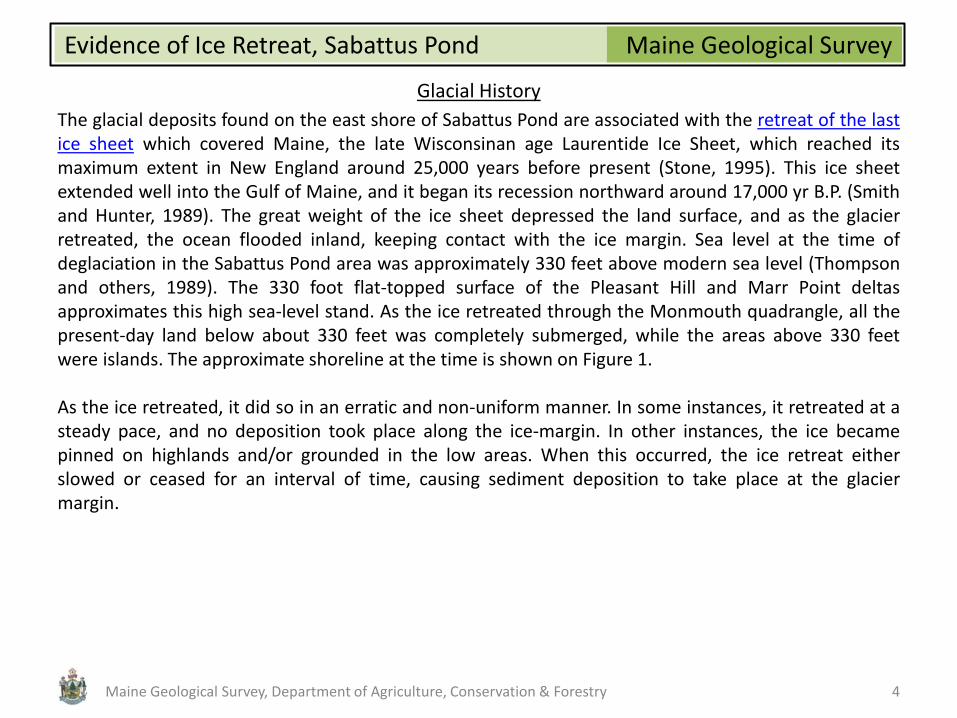
Pleasant Hill Delta
Starting at Drinkwater Corner (Figure 1), as you proceed north on Pleasant Hill Road you will be driving onto the flat-topped surface of the Pleasant Hill delta. Deltas like this one are composed primarily of sorted and stratified sand and gravel deposits graded to the surface of the late-glacial sea and are distinguished by the flat surface and the internal layers of the deposits: the topset, foreset, and bottomset beds (Figure 3).
Figure 3. Internal layers in a delta: topset, foreset, and bottomset beds.
Maine Geological Survey Ph
oto
by
Mai
ne
Geo
logi
cal S
urv
ey
Maine Geological Survey, Department of Agriculture, Conservation & Forestry 6
Maine Geological Survey Evidence of Ice Retreat, Sabattus Pond
Pleasant Hill Delta
The Pleasant Hill delta is characteristic of many ice-contact deltas, with its steep northward-dipping ice-contact slope and lobate kidney-shaped form (Figure 1). It is called a Gilbert-style delta, so named for deltas found in Utah and first described by G. K. Gilbert, a 19th-century geologist with the U. S. Geological Survey. Gilbert deltas in Maine formed where glacial streams discharged coarse sediment (sand and gravel) into lake or ocean waters, and the sediment supply was sufficiently large in proportion to water depth that the deposit built up to the surface of the water body, with horizontal topset beds overlying inclined foreset beds. The foreset beds consist of interbedded fine to coarse sand and gravel. When examining these beds, their orientation can indicate the flow direction of the water which deposited these sand deposits. These are called paleocurrent measurements, and along with other features, they help determine where the edge of the glacier stood when the delta was formed.
Maine Geological Survey, Department of Agriculture, Conservation & Forestry 7

Maine Geological Survey Evidence of Ice Retreat, Sabattus Pond
Pleasant Hill Delta
On the flat surface immediately on the right side of the road is a cemetery (Figure 4). If you park there and walk to the rear of the cemetery you will see a sand and gravel extraction operation (Figure 5), which gives you an opportunity to observe the internal structure of a glaciomarine delta.
Figure 4. View of the Pleasant Hill Cemetery showing the flat surface of the Pleasant Hill delta.
Maine Geological Survey Ph
oto
by
Mai
ne
Geo
logi
cal S
urv
ey
Maine Geological Survey, Department of Agriculture, Conservation & Forestry 8

Maine Geological Survey Evidence of Ice Retreat, Sabattus Pond
Pleasant Hill Delta
Also, you will be overlooking the valley of Maxwell Brook along which the Maine Turnpike runs. You can imagine the valley 13,000 years ago, filled with the ocean nearly up to the cemetery, and not but a short distance behind you the snout of the retreating glacier margin. Maybe walrus would have been sunning themselves on the delta surface, and whales breaching, feeding, and spouting as they swam by the glacier front!
Figure 5. Gravel extraction operation on the east side of the Pleasant Hill delta, as seen from the Pleasant Hill Cemetery. Note the shallow-dipping foreset beds in the center of the photo.
Maine Geological Survey Ph
oto
by
Mai
ne
Geo
logi
cal S
urv
ey
Maine Geological Survey, Department of Agriculture, Conservation & Forestry 9

Maine Geological Survey Evidence of Ice Retreat, Sabattus Pond
Kettle
As you proceed on Pleasant Hill Road, the road will begin to descend and you'll see Round Pond on your left. The descent in slope marks the former position of the ice margin, and is called an ice-contact slope. The sand and gravel of the delta was buttressed against the ice margin, which subsequently melted causing the sand and gravel to collapse. A detached block of ice from the glacier remained at the site of Round Pond, and later melted away to form a kettle hole. This ice-block depression now occupied by Round Pond is a kettle-hole pond (Figure 6).
Figure 6. View of Round Pond, a kettle-hole pond, looking down from the edge of Pleasant Hill Road.
Maine Geological Survey Ph
oto
by
Mai
ne
Geo
logi
cal S
urv
ey
Maine Geological Survey, Department of Agriculture, Conservation & Forestry 10

Maine Geological Survey Evidence of Ice Retreat, Sabattus Pond
Submarine outwash fans
Continue north on Pleasant Hill Road to its intesection with Route 9/126, and cross the intersection. As you travel north, now on Route 132, on the left side you will see a series of mounds and cone-shaped landforms, smaller in size and at lower elevations than the Pleasant Hill delta (Figure 7). These mounds are called submarine outwash fans.
Figure 7. View to the east from Route 132 showing several outwash fans. Note the gravel pit in the fan in the center-left in the photo.
Maine Geological Survey Ph
oto
by
Mai
ne
Geo
logi
cal S
urv
ey
Maine Geological Survey, Department of Agriculture, Conservation & Forestry 11

Maine Geological Survey Evidence of Ice Retreat, Sabattus Pond
Submarine outwash fans
Outwash fans are thick sand and gravel accumulations (Figure 8), and like the delta they formed at the mouth of subglacial tunnels along the receding late Pleistocene ice margin. They are similar to deltas, but either sediment supply was inadequate to build the deposit up to sea-level, water depth was too great, or the speed of ice retreat was too fast to allow time for complete delta formation. Each fan represents a different ice margin position, each successively deposited as the ice margin retreated.
Figure 8. Glaciomarine fan deposits in a coarse to medium sand with low-angle, inclined bedding.
Maine Geological Survey Ph
oto
by
Mai
ne
Geo
logi
cal S
urv
ey
Maine Geological Survey, Department of Agriculture, Conservation & Forestry 12

Maine Geological Survey Evidence of Ice Retreat, Sabattus Pond
Submarine outwash fans
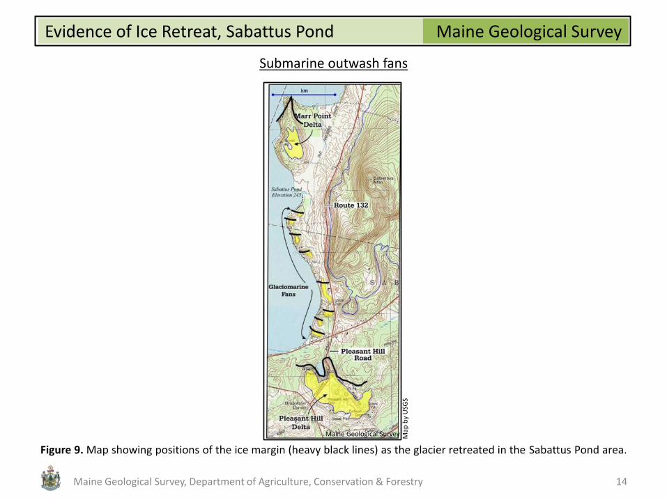
The series of submarine outwash fans along the eastern edge of Sabattus Pond have been named the Sabattus Pond fans (Figure 1). These are a good example of a deposit known as a "beaded esker" (Caldwell and others, 1985). Instead of forming an esker, which is a long uniform ridge of sand and gravel formed by deposition within an ice tunnel, the margin of the glacier retreats rapidly and material from the ice-tunnel is deposited at the margin as a series of segmented fans, or "beads." The Sabattus Pond fans separate two larger deposits, the Marr Point delta, and the Pleasant Hill delta. These larger deltas are part of the same ice tunnel system that deposited the fans, and may represent a period of several years when the ice margin was at a relative stillstand (Figure 9). Alternatively, the deltas could reflect an increase in meltwater discharge from the ice tunnel during ice retreat. Yet another explanation could have the deltas as the winter position of the margin, when ice retreat may have been slowest, and the intervening fans represent the increased retreat rate during the summer season.
Maine Geological Survey, Department of Agriculture, Conservation & Forestry 13
Maine Geological Survey Evidence of Ice Retreat, Sabattus Pond
Submarine outwash fans
Figure 9. Map showing positions of the ice margin (heavy black lines) as the glacier retreated in the Sabattus Pond area.
Maine Geological Survey Map
by
USG
S
Maine Geological Survey, Department of Agriculture, Conservation & Forestry 14

Maine Geological Survey Evidence of Ice Retreat, Sabattus Pond
End moraines
As you continue north approaching Sabattus Mountain, subtle ridges on your left will start to appear, becoming more prominent as you head north (Figure 10).
Figure 10. View west from Route 132 showing end moraine ridges in the foreground. Flat-topped ridge in background at upper left is the Marr Point delta.
Maine Geological Survey Ph
oto
by
Mai
ne
Geo
logi
cal S
urv
ey
Maine Geological Survey, Department of Agriculture, Conservation & Forestry 15

Maine Geological Survey Evidence of Ice Retreat, Sabattus Pond
End moraines
The ridges are end moraines, some of which are aligned adjacent to a submarine fan. The orientation of the moraine is nearly perpendicular to the trend of the ice-tunnel system represented by the fans (Figure 1). End moraines are linear, lobate ridges consisting of sand and gravel interbedded with Presumpscot Formation silty clay. These ice-front deposits are generally parallel to the former margin of the retreating ice sheet (Ashley and others, 1991), and therefore can be used to trace ice-marginal positions during deglaciation. The curvilinear orientation of the moraines around Sabattus Pond, is due to the pinning of the glacier on the uplands of Sabattus Mountain, slowing the glacial retreat, while in the lowlands along the lake the ice retreated faster causing the curvature of the moraine.
Maine Geological Survey, Department of Agriculture, Conservation & Forestry 16
Maine Geological Survey Evidence of Ice Retreat, Sabattus Pond
Glaciomarine delta - Marr Point Delta
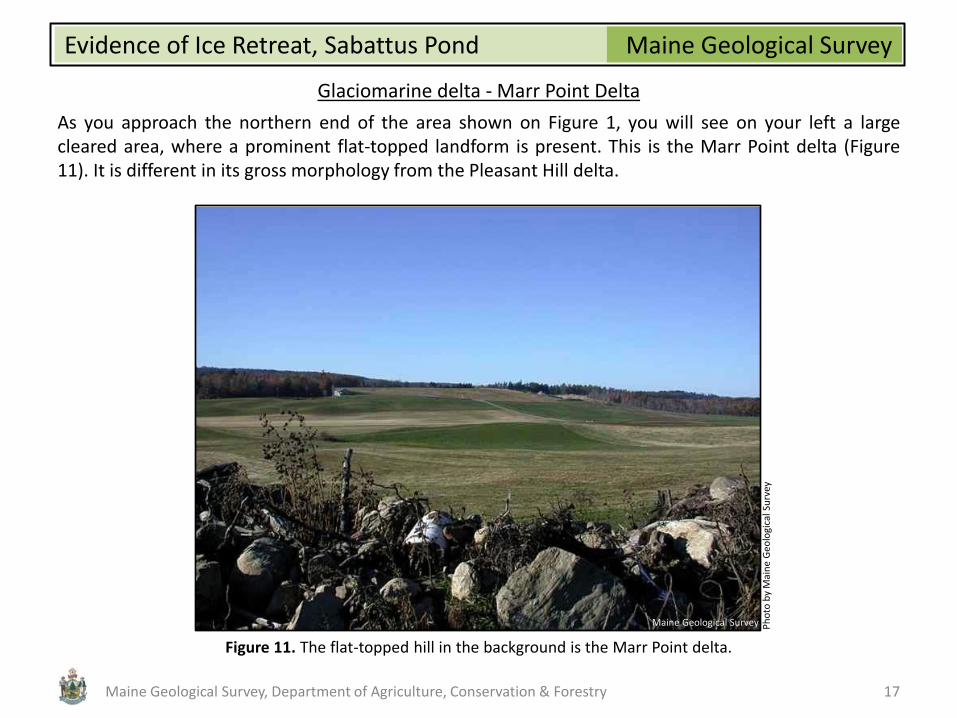
As you approach the northern end of the area shown on Figure 1, you will see on your left a large cleared area, where a prominent flat-topped landform is present. This is the Marr Point delta (Figure 11). It is different in its gross morphology from the Pleasant Hill delta.
Figure 11. The flat-topped hill in the background is the Marr Point delta.
Maine Geological Survey Ph
oto
by
Mai
ne
Geo
logi
cal S
urv
ey
Maine Geological Survey, Department of Agriculture, Conservation & Forestry 17

Maine Geological Survey Evidence of Ice Retreat, Sabattus Pond
Glaciomarine delta - Marr Point Delta
The relatively flat surface elevation of each delta is at about 330 feet above sea level. Both have an elongate northern end, most prominent on the Marr Point delta. A ridge traceable along Pleasant Hill Road enters the northern end of the Pleasant Hill delta just east of Round Pond (a kettle pond). These features represent the position of the ice-tunnel at or near the ice margin, where debris emanated from the tunnel to build the deposits (Figure 12).
Figure 12. Ice tunnel deposit, north end of Marr Point delta.
Maine Geological Survey Ph
oto
by
Mai
ne
Geo
logi
cal S
urv
ey
Maine Geological Survey, Department of Agriculture, Conservation & Forestry 18

Maine Geological Survey Evidence of Ice Retreat, Sabattus Pond
Glaciomarine delta - Marr Point Delta
The Pleasant Hill delta is a kidney-shaped form, more lobate than the Marr Point delta, which is wedge-shaped. The Pleasant Hill delta likely represents laterally migrating and coalescing delta or fan lobes along the ice margin. The Marr Point delta may represent a delta deposited with little or no lateral migration of the tunnel feeder source. Bernatovicz (1994) noted a change in orientation of end moraines near the Marr Point delta front and suggested that the shift from a roughly east-west trend (parallel to the ice margin), to a northwest-southeast trend reflects opening and enlargement of the margin near the ice tunnel, thus allowing lateral expansion of the Marr Point delta. During deglaciation as the ice margin retreated in the Sabattus Pond lowland, it was pinned to the east at Sabattus Mountain, and the shift in moraine trends also represents the influence of the highland as a pinning point as the ice margin passed through the area.
Maine Geological Survey, Department of Agriculture, Conservation & Forestry 19

Maine Geological Survey Evidence of Ice Retreat, Sabattus Pond
References and Additional Information
Ashley, G. M., Boothroyd, J. C., and Borns, H. W., Jr., 1991, Sedimentology of late Pleistocene (Laurentide) deglacial-phase deposits, eastern Maine; an example of a temperate marine grounded ice-sheet margin, in Anderson, J. B., and Ashley, G. M. (editors), Glacial marine sedimentation; paleoclimatic significance: Geological Society of America, Special Paper 261, p. 107-125.
Bernotavicz, A. A., 1994, Glacial and postglacial history of the Sabattus River valley, Sabattus, Maine: B. A. Thesis, Bates College,
Lewiston, Maine, 141 p. Caldwell, D. W., Hanson, L. S., and Thompson, W. B., 1985, Styles of deglaciation in central Maine, in Borns, H. W., Jr., LaSalle, P.,
and Thompson, W. B. (editors), Late Pleistocene history of northeastern New England and adjacent Quebec: Geological Society of America, Special Paper 197, p. 45-57.
Retelle, M. J., and Weddle, T. K., 2001, Deglaciation and relative sea-level shronology, Casco Bay Lowland and lower Androscoggin
River valley, Maine, in Weddle, T. K., and Retelle, M. J. (editors), Deglacial history and relative sea-level changes, northern New England and adjacent Canada: Geological Society of America, Special Paper 351, p. 193-216.
Smith, G. W., and Hunter, L. E., 1989, Late Wisconsinan deglaciation of coastal Maine, in Tucker, R. D., and Marvinney, R. G.,
(editors), Studies in Maine geology, Volume 6 - Quaternary geology: Maine Geological Survey, p. 13-32. Stone, B. D., 1995, Progress toward higher resolution of the Late Wisconsinan deglaciation sidereal chronology of the New
England region, 30 to 13 ka: Geological Society of America, Abstracts with Program, v. 26, no. 3, p. 84. Thompson, W. B., Crossen, K. J., Borns, H. W., Jr., and Anderson, B. G., 1989, Glaciomarine deltas of Maine and their relation to
late Pleistocene-Holocene crustal movements, in Anderson, W. A., and Borns, H. W., Jr. (editors), Neotectonics of Maine: studies in seismicity, crustal warping, and sea-level change: Maine Geological Survey, Bulletin 40, p. 43-67.
Maine Geological Survey, Department of Agriculture, Conservation & Forestry 20