Embed Size (px)
Citation preview
Geodatabase development
Deliverable No.: D.02.02
GA 2. GIS Development, activities 2.3 & 2.5
RESPONSIBLE: TEI of Central Macedonia (LP)
INVOLVED PARTNERS: ALL

Black Sea JOP, “SCInet NatHaz”
GeoDatabase Development
Deliverable-No. D.02.02 Final version
Issue: I.05 Date: 11th July 2014 Page: 2 of 33
Project Details
Programme
Black Sea JOP
Priority and Measure
Priority 2 (Sharing resources and competencies for environmental protection and conservation), Measure 2.1. (Strengthening the joint knowledge and information base needed to address common challenges in the environmental protection of river and maritime systems)
Objective
Development of a Scientific Network
Project Title
A Scientific Network for Earthquake, Landslide and Flood Hazard Prevention
Project Acronym
SCInet NatHaz
Contract No
MIS-ETC 2614
Lead Partner
TEI OF KENTRIKI MAKEDONIA, GREECE
Total Budget
700.000,00 Euro (€)
Time Frame Start Date – End Date
01/05/2013 – 30/04/2015
Book Captain: K. PAPATHEODOROU (TEI KENTRIKI MAKEDONIA) Contributing Authors:
D. Kotzinos, K. Papatheodorou, K. Ntouros, K. Evangelidis, K. Konstantinidou (EPPO)
Black Sea JOP, “SCInet NatHaz”
GeoDatabase Development
Deliverable-No. D.02.02 Final version
Issue: I.05 Date: 11th July 2014 Page: 3 of 33
Document Release Sheet
Book captain: K. PAPATHEODOROU (TEI
CENTRAL MACEDONIA) 11.07.2014
Approval K. PAPATHEODOROU (TEI
CENTRAL MACEDONIA) 11.07.2014
Approval A.ANSAL
(IPA – BU-KOERI)
11.07.2014
Approval N. KLIMIS
(Partner 1 - DUTH) 11.07.2014
Approval V. MARGARIS
(Partner 2 - EPPO) 11.07.2014
Approval V. NENOV
(Partner 3 - Burgas Assen Zlatarov University)
11.07.2014
Approval L. TOFAN
(Partner 4 - Ovidius University of Constanta) 11.07.2014
Approval
A.SIDORENKO (Partner 5 – IEEN
“D.GHITU” Of Academy Of Sciences Of Moldova)
11.07.2014
Approval
K. STEPANOVA (Partner 6 - Ukranian
Environmental Academy Of Sciences, Black Sea
Branch) 11.07.2014
Approved by the Project
Coordinator:
K. PAPATHEODOROU
11.07.2014
Distribution: ALL PARTNERS
Black Sea JOP, “SCInet NatHaz”
GeoDatabase Development
Deliverable-No. D.02.02 Final version
Issue: I.05 Date: 11th July 2014 Page: 4 of 33
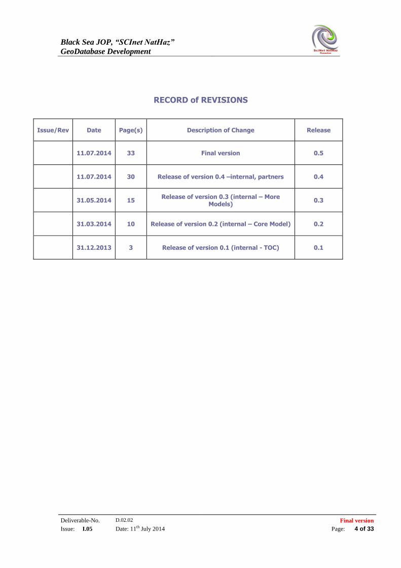
RECORD of REVISIONS
Issue/Rev Date Page(s) Description of Change Release
11.07.2014 33 Final version 0.5
11.07.2014 30 Release of version 0.4 –internal, partners 0.4
31.05.2014 15 Release of version 0.3 (internal – More
Models) 0.3
31.03.2014 10 Release of version 0.2 (internal – Core Model) 0.2
31.12.2013 3 Release of version 0.1 (internal - TOC) 0.1
Black Sea JOP, “SCInet NatHaz”
GeoDatabase Development
Deliverable-No. D.02.02 Final version
Issue: I.05 Date: 11th July 2014 Page: 5 of 33
TABLE OF CONTENTS
1 BACKGROUND OF THE DOCUMENT 7
1.1 SUMMARY 7 1.2 SCOPE AND OBJECTIVES 7 1.3 RELATED DOCUMENTS 8 1.3.1 INPUT 8 1.3.2 OUTPUT 8
2 INTRODUCTION 9
2.1 PRINCIPLES OF INFORMATION INTEGRATION 9 2.2 URI CONSTRUCTION 10
3 THE (GEO) SCIENTIFIC OBSERVATION MODEL 12
3.1 PURPOSE 12 3.1.1 ENABLING OF INFORMATION INTEROPERABILITY AND INTEGRATION 13 3.1.2 AN EXTENSION OF THE CIDOC CRM 13 3.2 CORE MODEL DESCRIPTION 14 3.3 THEME 1: FLOODS CORE MODEL 17 3.4 THEME 2: SEISMIC CORE MODEL 21 3.5 THEME 3: LANDSLIDES CORE MODEL 25
4 EXAMPLE: DETAILED ANALYSIS OF THE SEISMIC DATA THEME 27
4.1 STATIONS AND SENSORS NETWORK 28 4.2 EARTHQUAKE EVENT 29 4.3 SEISMIC RECORDING 30
5 CONCLUSIONS 31
6 REFERENCES 31
7 ANNEX I – DETAILED DESCRIPTION OF THE (GEOSCIENTIFIC
OBSERVATION) CONCEPTUAL MODEL 33
Black Sea JOP, “SCInet NatHaz”
GeoDatabase Development
Deliverable-No. D.02.02 Final version
Issue: I.05 Date: 11th July 2014 Page: 6 of 33
LIST OF FIGURES Figure 1: Basic Concepts [ING12] _______________________________________________________________________ 15 Figure 2: Material and immaterial things [ING12] ____________________________________________________ 16 Figure 3: Flood measurements and related measurement stations ___________________________________ 17 Figure 4: Hydraulic structures and corresponding maps ______________________________________________ 18 Figure 5: Hydraulic structure’s properties _____________________________________________________________ 19 Figure 6: Entities and Networks involved in floods management _____________________________________ 20 Figure 7: Definition of floods’ elements _________________________________________________________________ 21 Figure 8: Observation on earthquakes [ING12] ________________________________________________________ 22 Figure 9: Types of seismic phenomena [ING12] ________________________________________________________ 23 Figure 10: Distribution of an earthquake [ING12] _____________________________________________________ 24 Figure 11: Stations and accelerometers [ING12] ______________________________________________________ 24 Figure 12: Shock wave recording [ING12] _____________________________________________________________ 25 Figure 13: Landslides core model: features ____________________________________________________________ 26 Figure 14: Landslides core model: Observations and Data Evaluation _______________________________ 27 Figure 15: Stations and Sensors Network ______________________________________________________________ 29 Figure 16: Earthquake Event ___________________________________________________________________________ 30 Figure 17: Seismic Recording ___________________________________________________________________________ 31
LIST OF TABLES Table 1. Categories of the different concepts in the Seismic Model ........................................................ 28
Black Sea JOP, “SCInet NatHaz”
GeoDatabase Development
Deliverable-No. D.02.02 Final version
Issue: I.05 Date: 11th July 2014 Page: 7 of 33
1 BACKGROUND OF THE DOCUMENT
1.1 SUMMARY
This document provides an overview of the data modeling activities in the project. The
project adopted and extended substantially an already existing data and metadata model that is
used to describe geospatial events and the geoscientific observations and measurements
around them.
This is an event driven model, which allows for the description of natural geospatial
phenomena as events and associates them with the place and the time span of their
occurrence. This allows for an exact and rich modeling of the information. Additionally the
model is built in a way that facilitates information integration, which allows the integration of
data coming from the different partners, which can follow a different structure and a different
format.
Finally this conceptual model is extensible (which was proven since we extended it to cover
concepts not existing in the original version) and can be easily updated to cover additional
areas around natural hazards.
1.2 SCOPE AND OBJECTIVES
The document aims at describing information integration issues with emphasis on geospatial
information and specifically the area of natural hazards’ management. This is a critical are
since the proper management of such events highly affects the lives of individuals. The
management of such information in an integrated way is critical for the successful reaction
and management of such phenomena. So the main objective of this document is to describe an
integrated conceptual model that allows researchers to integrate different kind of information
that might need to manage together, i.e. the management of tsunami events after an
earthquake becomes more and more common; for the successful management of such
integrated events, integrated models as the proposed one are needed.
The proposed model builds on existing models that have become standards in the
corresponding communities. But with the exception of INSPIRE there is no other data and
metadata model that handles in an integrated way such diverse and rich information. So this
document aims at describing the new concepts introduced by the model around the three main
themes (floods, earthquakes, landslides) that are relevant to the project’s scope and not to
reintroduce all the concepts that have been defined in all other models that are referenced.
When needed the reader is referred to these models descriptions to acquire a more in deep
understanding of certain concepts.
Final the document’s scope is limited to provide a high level description and understanding
for the model’s user of the different concepts, their hierarchy and the relations among them.
The document does not aim at providing in its core a detailed description of each class and
Black Sea JOP, “SCInet NatHaz”
GeoDatabase Development
Deliverable-No. D.02.02 Final version
Issue: I.05 Date: 11th July 2014 Page: 8 of 33
property introduced; this is for the document’s Annex (Annex I), which is delivered with the
document and where all the introduced concepts (both classes and properties) are numbered,
explained conceptually and their position in the hierarchy along with their relations with other
concepts in the model are explained. The reader is urged to refer to the Annex if some
descriptions in the text are deemed not clear. Giving a high level view has been chosen given
the number of diverse scientific disciplines covered by the model and the fact that describing
everything in the outmost detail would be useless for the usual reader who looks to
understand the main concepts of the model and then probably focus on the part that he needs
to use most.
So this document is a high level description of the main (core) concepts of the model along
with the core concepts of the three main themes described by it.
1.3 RELATED DOCUMENTS
1.3.1 Input
List of former deliverables acting as inputs to this document
Document ID Descriptor
D.2.01 Data collection and data processing
1.3.2 Output
List of other deliverables for which this document is an input.
Document ID Descriptor
D.2.03 WebGIS Development
Black Sea JOP, “SCInet NatHaz”
GeoDatabase Development
Deliverable-No. D.02.02 Final version
Issue: I.05 Date: 11th July 2014 Page: 9 of 33
2 INTRODUCTION
2.1 PRINCIPLES OF INFORMATION INTEGRATION
SCInetNatHaz project deals with publishing diverse data that can extend at a large-scale,
which means that many different and diverse datasets will be made available through the
project’s infrastructure. Users of these datasets are usually interested in combining
information crossing through the available datasets regardless of origin, purpose or format.
This means that we need eventually to deal with data integration issues at various levels and
with various degrees of coupling.
Data integration means, among other things, that we need to provide end users with the notion
that a single common well-managed data source exists instead of many – distributed or not –
individual ones. The database community has introduced the concept of integrated data-
spaces ([FHM05], [HFM06], [HFM06]) as a response to this problem. Integrated data-spaces
should make use of techniques that infer relationships between data sources and that refine
them in the light of additional information extracted from related data sources. Although there
do exist a wide range of proposals either for specific components (e.g. [SDH08, JFH08]) or
for complete data-space management systems (e.g. [DS2006], [MCD+07]), there is a lack of
major commonalities since existing proposals stem from quite different application contexts
and data paradigms.
Overcoming this diversity is the objective of the recent W3C Linked Open Data1 (LOD)
initiative for a unifying, machine-readable data representation that makes it possible to
semantically access and interlink heterogeneous but (semi-)structured resources at data level
– no matter what the structure of the data is, who created it, or where it comes from.
Exhibiting a higher degree of interoperability (than documents) and ease of reuse, Linked
Open Data has become a prominent choice for sharing (semi-) structured data on the web
originating from heterogeneous sources (Enterprises, Scientific communities, Press
institutions, but also emerging Social Media applications). Linked Open Data offers great
potential for building innovative applications that create new value from the already collected
data. Thus Linked Open Data is an effort of integrating semantically described data on RDF
and thus, can be used for the creation of semantically interoperable data-spaces.
Using Linked Open Data principles and practices allow easy integration of datasets of the
project with other datasets and the broader Semantic Web. In order to do that we might need
to express our data using tools and languages used by the semantic web. These include but are
not limited to, using RDF or OWL as the main languages of communication and using their
underlying models for the semantic descriptions and the interoperability among the different
datasets and using SPARQL as the main query language for managing the data and the
metadata. Current efforts in the area of geospatial information like the INSPIRE Directive,
although provide a comprehensive coverage of many and diverse domains of information, do
not provide yet a layer of semantic descriptions that can be directly used and exploited on the
1 http://linkeddata.org/
Black Sea JOP, “SCInet NatHaz”
GeoDatabase Development
Deliverable-No. D.02.02 Final version
Issue: I.05 Date: 11th July 2014 Page: 10 of 33
semantic web and for linking with other datasets. Based on that the current document
describes an effort to provide an information integration layer over the existing datasets that
would allow them to retain their existing formats while allowing for seamless information and
query integration for data and metadata models. Similar efforts have been reported in the
literature, e.g. [TSS2011] but usually address the issue at a different (syntactic) level or
assume that our datasets are already INSIRE compliant, which was not the case in our project.
Finally an important part of publishing data as Linked Open Data is the ability to employ
URIs as the unique (and hopefully persistent) identifiers (IDs) for each data object published.
URIs (Universal Resource Identifiers) have been proposed early enough in the semantic web
initiative [BFM05] as the main mean for resource identification. A constant problem, that the
semantic web is facing, is the lack of a global authority that would be responsible to assign
such URIs. Since such a task would definitely have a sequence of implications on the
operation of the semantic web the chosen path of action in this area has been the assignment
of URIs at the highest possible level. A discussion on URI creation issues can be found in the
next subsection..
Thus this document covers the necessary issues to allow the project partners to publish their
datasets and supports publication in a semantic web and especially Linked Open Data
compliant way, which is becoming a de facto requirement in many cases of public data
publication. This document is based on and extends Deliverable 2.2 of the InGeoClouds
Project (www.ingeoclouds.eu), which firstly introduced the described model for their needs.
This model was evaluated and adopted by the SCInet NatHaz projects as it covers the
project’s needs in terms of modeling data regarding earthquakes and landslides and has been
extended to also cover data regarding floods [ING12]. The project believes that extending
work produced by other EU supported projects and reusing existing conceptual data models
contributed to the uniformity of the data production in the scientific areas covered by the
project and provides a more extended validation and visibility of the work. The extensions
provided by SCInet NatHaz project are clearly identified in the text.
2.2 URI CONSTRUCTION
The need for unique identification of data objects has a long tradition stemming from the
relational databases tradition of unique keys. Producing unique ways to identify data allows
for:
Matching information for the data at hand with information declared elsewhere for
the same data
Differentiate a specific data point from others that might have similar characteristics.
In the Semantic Web and Linked Open Data tradition the unique keys have been replaced by
Universal Resource Identifiers (URIs). As also described in [IGC12], a Universal Resource
Identifier (URI) [BFM05, DS06] serves to uniquely identify information objects or real world
entities, be they local or published on the Internet (“Semantic Web”). URLs are a special case
of URIs, with a particular syntax. They normally identify the location of a document on a
Black Sea JOP, “SCInet NatHaz”
GeoDatabase Development
Deliverable-No. D.02.02 Final version
Issue: I.05 Date: 11th July 2014 Page: 11 of 33
server visible on the Internet. Therefore, it is a good practice to identify the document itself by
a location independent URI (more good practices on URI construction can be found at:
http://www.w3.org/2011/gld/wiki/223_Best_Practices_URI_Construction and other generic
suggestions from EU bodies like EU commission regulation No 1089/2010 and EU
commission regulation No 1205/2008 do exist2).
Other relevant forms of URIs are:
Universal Resource Names (URN). Organizations can request a domain name at
IANA3 to be used following the “urn:” prefix, and define their own syntax and
resolution rules.
Digital Object Identifiers (DOI), managed by http://www.doi.org, a central authority
hierarchically delegating subdomains to institutions, but only for digital objects.
Universally Unique IDentifier (UUID): With the help of a random algorithm, a UUID
generator can generate a most likely new identifier without a central authority.
The worst case for information integration is, when everybody declares a new identifier for
something, without others knowing. From a use point of view, we have to consider three basic
questions: (a) how will I know that an object has gotten an identifier at all; (b) who will be
able to confirm that the object is indeed identified by this identifier, and what that means; (c)
how will I be able to find the object if you give me only an identifier. After this, the question
that might appear is what to do if an object has more than one identifier, or if an identifier is
used wrongly in a description.
For the needs of this project, we recommend a mixed approach:
For all items only locally known to a particular dataset, a UUID is the best solution. It
is generated locally, and anybody to use it in the future will learn about the item only
in connection with this identifier, and hence together with the knowledge of the item,
will also have the knowledge of the identifier.
For all items publicly known to belong to a certain institution, the institution can
maintain LOD identifiers, such as for boreholes, measurement equipment,
laboratories, because people will search there for “official identifiers” of those items.
Institutions can apply their own policy (according to LOD guidelines) or follow a
policy specified within their domain or country of origin.
2 In the COMMISSION REGULATION (EU) No 1089/2010 of 23 November 2010 about
“Interoperability of spatial data sets and services”, the definition is given for a ‘identifier’ [of an
object]: means a linguistically independent sequence of characters capable of uniquely and permanently
identifying that with which it is associated, in accordance with EN ISO 19135”. The annex I of the
directive defines a more precise definition of the “External unique object identifier published by the
responsible body, which may be used by external applications “ and describes the attributes of each
identifier:
localID : identifier in the namespace
namespace : Namespace uniquely identifying the data source of the spatial objet
versionID : The identifier of the particular version of the spatial object with a maximum length of
25 character 3 www.iana.org
Black Sea JOP, “SCInet NatHaz”
GeoDatabase Development
Deliverable-No. D.02.02 Final version
Issue: I.05 Date: 11th July 2014 Page: 12 of 33
For industrial products of companies providing scientific equipment, we recommend
the creation of “pseudo LOD identifiers” by a suitable combination of the company’s
web domain, the company’s product identifier (and serial number), as long as they do
not offer LOD identifiers themselves already.
For place names we recommend to use the identifiers of a suitable gazetteer service
(e.g.GeoNames4). If the gazetteer service does not provide URIs, a “pseudo LOD
identifier” can be created from the domain name of the service and the respective
place name identifier.
It is to be expected that organizations introducing identifiers at a later time, will follow a
method, which will allow for automatically matching our “pseudo LOD identifiers” with the
future correct LOD identifiers. It should also be noted that the generation of unique
URIs is not a requirement when the data are kept at a local level and are not directly
shared on the web or not plan to be extensively mixed with a lot of external datasets.
3 THE (GEO) SCIENTIFIC OBSERVATION MODEL
3.1 PURPOSE
This model is built (as it is also stated in [ING12]) as a common specification or an ontology
model that supports data sources integration from different data providers (geospatial
databases) in order to share data. The data providers are all public sector or research bodies
and thus the project is supporting Community policy in the Re-use of Public Sector
Information Directive. In addition to this it will enable a more complete and coherent
implementation of Groundwater and Soils protection Directives. It will directly support
GMES and GEOSS.
The Global Earth Observation System of Systems (GEOSS) is being built by the Group on
Earth Observations (GEO). GEOSS seeks to connect the producers of environmental data and
decision-support tools with the end users of these products, with the aim of enhancing the
relevance of Earth observations to global issues. The end result is to be a global public
infrastructure that generates comprehensive, near-real-time environmental data, information
and analyses for a wide range of users. The earth observation systems consist of instruments
and models designed to measure, monitor and predict the physical, chemical and biological
aspects of the Earth system. Our conceptual model has been created or extended based on
standards in order to answer the needs of this project. Regardless of the fact whether the
project plans or not to publish on the web directly the available datasets we decided that it
will beneficial for all to provide a more state of the art description of the data models and thus
we adopted a paradigm based on the semantic web principles.
4 www.geonames.org
Black Sea JOP, “SCInet NatHaz”
GeoDatabase Development
Deliverable-No. D.02.02 Final version
Issue: I.05 Date: 11th July 2014 Page: 13 of 33
3.1.1 Enabling of information interoperability and integration
Mediation tools and Semantic Web activities require an integrated, shared ontology for the
information accumulated by different scientific domains. In addition, such interrelationships
should be either integrated in common information storage, or at least virtually integrated
through mediation devices that allow a query to be simultaneously launched on distinct
information depositories, which in all cases requires common semantic tools.
The model needs a standard way of publishing the data as RDF and especially, ways of
providing unique URIs are required for the data used within the project. The model is
designed as a generic, extendable and interoperable model, which relies not only to
geographic data but also for the documentation of scientific observation and measurement in
general. It integrates different datasets created from sources w.r.t. their semantics. It is an
event-centric model that captures complex historical contexts where time, place and
participants are associated; so, it is capable to describe complex relationships and to integrate
or connect rich information.
3.1.2 An extension of the CIDOC CRM
CIDOC CRM is explicitly compatible in formalism with the World Wide Web Consortium’s
Resource Description Framework (RDF), which can only be beneficial for our model. This is
also an opportunity to extend the scope of the CIDOC CRM to geo-scientific information.
Consequently, it opens the way for a model to benefit from further extensions of the scope of
CIDOC CRM, such as the scientific heritage of observations and experiments.
3.1.2.1 Sources
CIDOC CRM
The CIDOC CRM5 model was being developed from 1996 under the auspices of the ICOM-
CIDOC (International Council for Museums – International Committee on Documentation)
Documentation Standards Working Group. The definition of the CIDOC CRM model has
now become ISO standard 21127 [CID11].
INSPIRE
INSPIRE Directive is based on the infrastructures for spatial information established and
operated by the 27 Member States of the European Union. The Directive addresses 34 spatial
data themes needed for environmental applications, with key components specified through
technical implementing rules. One of the main tasks of the INSPIRE program is to enable the
interoperability and, where practicable, harmonization of spatial data sets and services within
Europe.
5 “CIDOC CRM” stands for “Comité international de documentation [= International
Committee on Documentation] Conceptual Reference Model,” which, when isolated from any
context, is not particularly meaningful (CIDOC is affiliated to ICOM, the International
Council of Museums).
Black Sea JOP, “SCInet NatHaz”
GeoDatabase Development
Deliverable-No. D.02.02 Final version
Issue: I.05 Date: 11th July 2014 Page: 14 of 33
The text of the INSPIRE Directive is available from the INSPIRE web site
(http://inspire.jrc.ec.europa.eu/) and
(http://eurlex.europa.eu/LexUriServ/LexUriServ.do?uri=CELEX:32007L0002:EN:NOT)
DUBLIN CORE The fifteen-element "Dublin Core" achieved wide dissemination as part of the Open Archives
Initiative Protocol for Metadata Harvesting (OAI-PMH) and has been ratified as IETF RFC
5013, ANSI/NISO Standard Z39.85-2007, and ISO Standard 15836:2009.. The Dublin Core
Metadata Element Set is a vocabulary of fifteen properties for use in resource description. The
name "Dublin" is due to its origin at a 1995 invitational workshop in Dublin, Ohio; "core"
because its elements are broad and generic, usable for describing a wide range of resources.
The fifteen-element "Dublin Core" described in this standard is part of a larger set of metadata
vocabularies and technical specifications maintained by the Dublin Core Metadata Initiative
(DCMI). The full set of vocabularies, DCMI Metadata Terms [DCMI-TERMS], also includes
sets of resource classes (including the DCMI Type Vocabulary [DCMI-TYPE]), vocabulary
encoding schemes, and syntax encoding schemes. Available online at
http://dublincore.org/metadata-basics/
3.2 CORE MODEL DESCRIPTION
The core model is extensively described in [ING12], here we include for completeness of the
text the main elements of its description and connect them with the extensions made; the
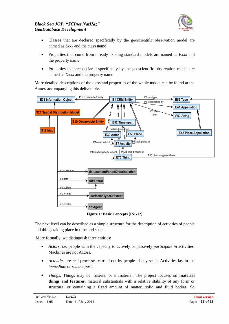
reader is referred to this document if further reading is deemed necessary. As we can see in
Figure 1, the core view of our universe of discourse is presented as consisting of event-centric
processes, rather than of static analysis and classification of products out of the human and
spatiotemporal context. Thus the core model describes fundamental notions of the core model
that answer basic questions of type “who did what when, where with what”, and expressed,
for example, in form of queries, such as “give me all the observations/ measurements made by
actor X at time Y, give me all the tools/software used for the outcome of activity X, give me
all the documents or maps that refer to this event, etc.
We distinguish classes and properties in the sense of the knowledge representation languages
proposed for the Semantic Web such as RDFS. Any particular individual item in the scope of
the model is regarded instance of a class Entity. Any instance of Entity may be further
classified by suitable terms - instances of Type - via the property “has type”. Additionally
any instance of entity can be identified by an appellation or an identifier and can be described
by a short note-description or comment.
For clarity and readability we have followed the following naming scheme throughout the
definition and description of the geoscientific observation model:
Classes that come from already existing standard models are named as Exx and the
class name
Black Sea JOP, “SCInet NatHaz”
GeoDatabase Development
Deliverable-No. D.02.02 Final version
Issue: I.05 Date: 11th July 2014 Page: 15 of 33
Classes that are declared specifically by the geoscientific observation model are
named as Sxxx and the class name
Properties that come from already existing standard models are named as Pxxx and
the property name
Properties that are declared specifically by the geoscientific observation model are
named as Oxxx and the property name
More detailed descriptions of the class and properties of the whole model can be found at the
Annex accompanying this deliverable.
Figure 1: Basic Concepts [ING12]
The next level can be described as a simple structure for the description of activities of people
and things taking place in time and space.
More formally, we distinguish three entities:
Actors, i.e. people with the capacity to actively or passively participate in activities.
Machines are not Actors.
Activities are real processes carried out by people of any scale. Activities lay in the
immediate or remote past.
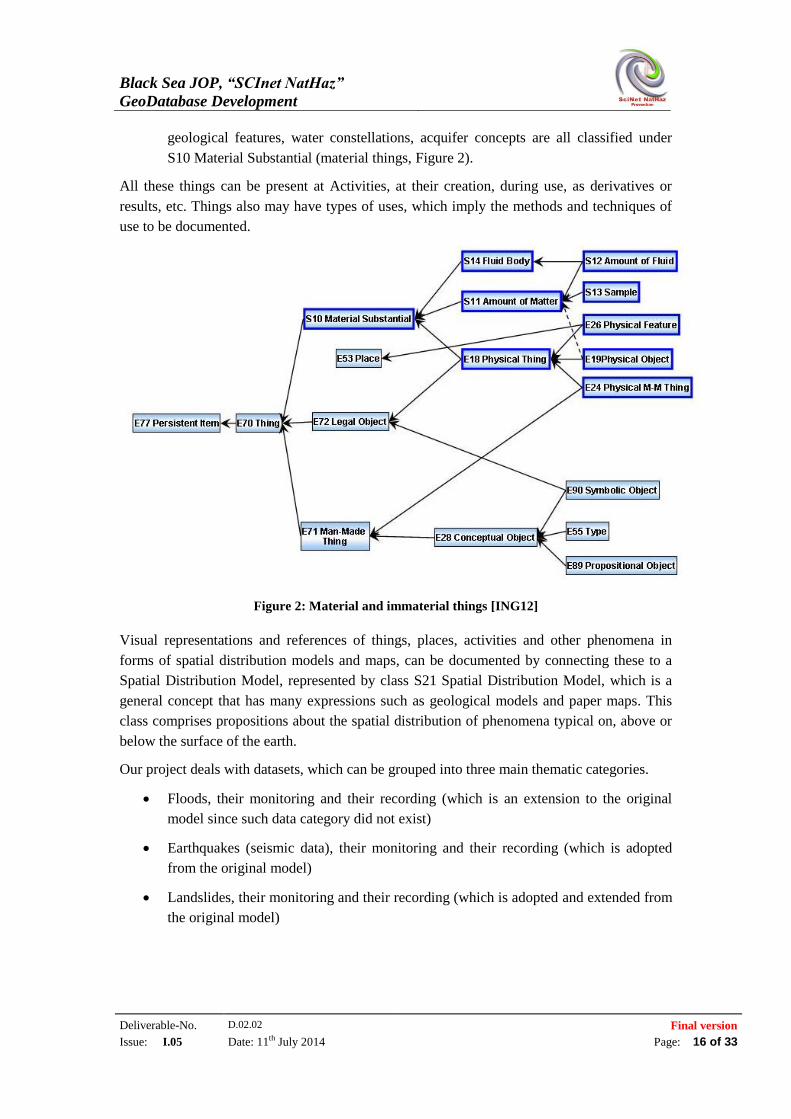
Things. Things may be material or immaterial. The project focuses on material
things and features, material substantials with a relative stability of any form or
structure, or containing a fixed amount of matter, solid and fluid bodies. So
Black Sea JOP, “SCInet NatHaz”
GeoDatabase Development
Deliverable-No. D.02.02 Final version
Issue: I.05 Date: 11th July 2014 Page: 16 of 33
geological features, water constellations, acquifer concepts are all classified under
S10 Material Substantial (material things, Figure 2).
All these things can be present at Activities, at their creation, during use, as derivatives or
results, etc. Things also may have types of uses, which imply the methods and techniques of
use to be documented.
Figure 2: Material and immaterial things [ING12]
Visual representations and references of things, places, activities and other phenomena in
forms of spatial distribution models and maps, can be documented by connecting these to a
Spatial Distribution Model, represented by class S21 Spatial Distribution Model, which is a
general concept that has many expressions such as geological models and paper maps. This
class comprises propositions about the spatial distribution of phenomena typical on, above or
below the surface of the earth.
Our project deals with datasets, which can be grouped into three main thematic categories.
Floods, their monitoring and their recording (which is an extension to the original
model since such data category did not exist)
Earthquakes (seismic data), their monitoring and their recording (which is adopted
from the original model)
Landslides, their monitoring and their recording (which is adopted and extended from
the original model)
Black Sea JOP, “SCInet NatHaz”
GeoDatabase Development
Deliverable-No. D.02.02 Final version
Issue: I.05 Date: 11th July 2014 Page: 17 of 33
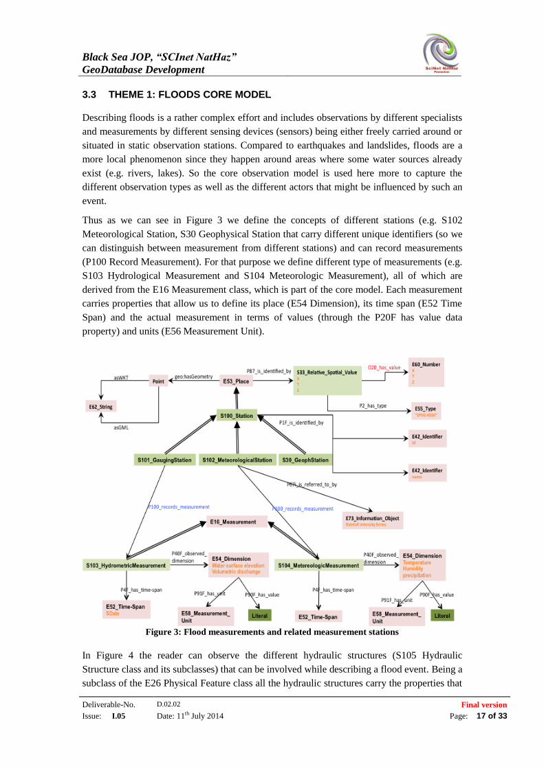
3.3 THEME 1: FLOODS CORE MODEL
Describing floods is a rather complex effort and includes observations by different specialists
and measurements by different sensing devices (sensors) being either freely carried around or
situated in static observation stations. Compared to earthquakes and landslides, floods are a
more local phenomenon since they happen around areas where some water sources already
exist (e.g. rivers, lakes). So the core observation model is used here more to capture the
different observation types as well as the different actors that might be influenced by such an
event.
Thus as we can see in Figure 3 we define the concepts of different stations (e.g. S102
Meteorological Station, S30 Geophysical Station that carry different unique identifiers (so we
can distinguish between measurement from different stations) and can record measurements
(P100 Record Measurement). For that purpose we define different type of measurements (e.g.
S103 Hydrological Measurement and S104 Meteorologic Measurement), all of which are
derived from the E16 Measurement class, which is part of the core model. Each measurement
carries properties that allow us to define its place (E54 Dimension), its time span (E52 Time
Span) and the actual measurement in terms of values (through the P20F has value data
property) and units (E56 Measurement Unit).
Figure 3: Flood measurements and related measurement stations
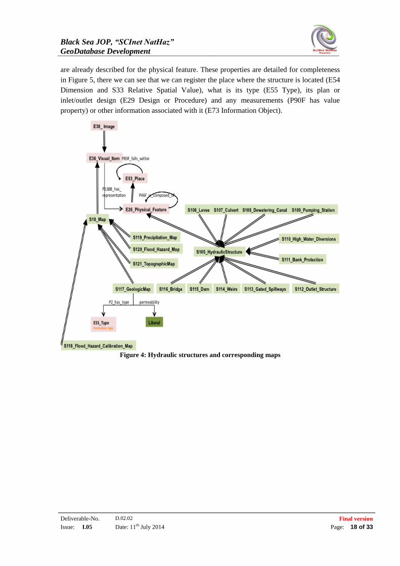
In Figure 4 the reader can observe the different hydraulic structures (S105 Hydraulic
Structure class and its subclasses) that can be involved while describing a flood event. Being a
subclass of the E26 Physical Feature class all the hydraulic structures carry the properties that
Black Sea JOP, “SCInet NatHaz”
GeoDatabase Development
Deliverable-No. D.02.02 Final version
Issue: I.05 Date: 11th July 2014 Page: 18 of 33
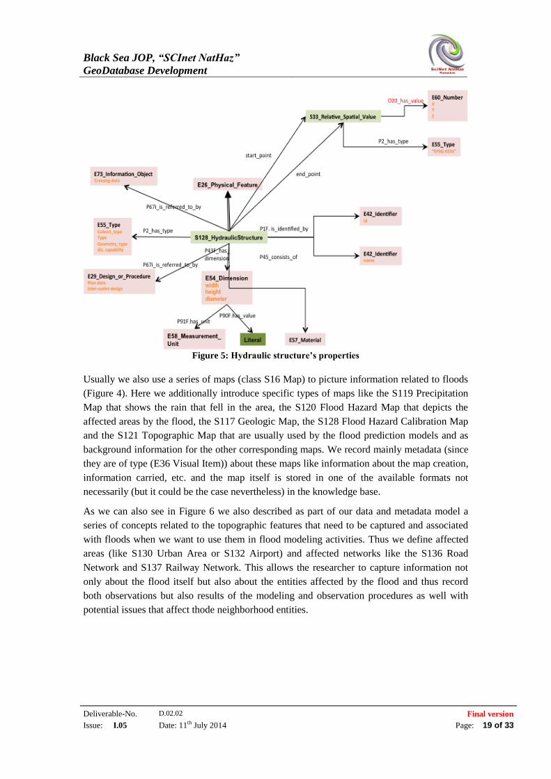
are already described for the physical feature. These properties are detailed for completeness
in Figure 5, there we can see that we can register the place where the structure is located (E54
Dimension and S33 Relative Spatial Value), what is its type (E55 Type), its plan or
inlet/outlet design (E29 Design or Procedure) and any measurements (P90F has value
property) or other information associated with it (E73 Information Object).
Figure 4: Hydraulic structures and corresponding maps
Black Sea JOP, “SCInet NatHaz”
GeoDatabase Development
Deliverable-No. D.02.02 Final version
Issue: I.05 Date: 11th July 2014 Page: 19 of 33
Figure 5: Hydraulic structure’s properties
Usually we also use a series of maps (class S16 Map) to picture information related to floods
(Figure 4). Here we additionally introduce specific types of maps like the S119 Precipitation
Map that shows the rain that fell in the area, the S120 Flood Hazard Map that depicts the
affected areas by the flood, the S117 Geologic Map, the S128 Flood Hazard Calibration Map
and the S121 Topographic Map that are usually used by the flood prediction models and as
background information for the other corresponding maps. We record mainly metadata (since
they are of type (E36 Visual Item)) about these maps like information about the map creation,
information carried, etc. and the map itself is stored in one of the available formats not
necessarily (but it could be the case nevertheless) in the knowledge base.
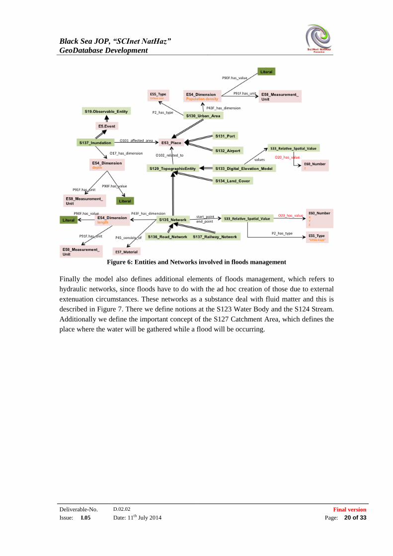
As we can also see in Figure 6 we also described as part of our data and metadata model a
series of concepts related to the topographic features that need to be captured and associated
with floods when we want to use them in flood modeling activities. Thus we define affected
areas (like S130 Urban Area or S132 Airport) and affected networks like the S136 Road
Network and S137 Railway Network. This allows the researcher to capture information not
only about the flood itself but also about the entities affected by the flood and thus record
both observations but also results of the modeling and observation procedures as well with
potential issues that affect thode neighborhood entities.
Black Sea JOP, “SCInet NatHaz”
GeoDatabase Development
Deliverable-No. D.02.02 Final version
Issue: I.05 Date: 11th July 2014 Page: 20 of 33
Figure 6: Entities and Networks involved in floods management
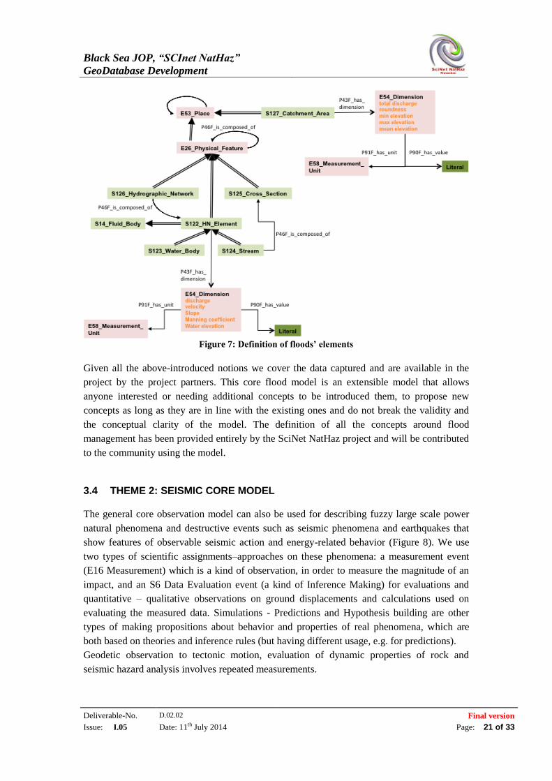
Finally the model also defines additional elements of floods management, which refers to
hydraulic networks, since floods have to do with the ad hoc creation of those due to external
extenuation circumstances. These networks as a substance deal with fluid matter and this is
described in Figure 7. There we define notions at the S123 Water Body and the S124 Stream.
Additionally we define the important concept of the S127 Catchment Area, which defines the
place where the water will be gathered while a flood will be occurring.
Black Sea JOP, “SCInet NatHaz”
GeoDatabase Development
Deliverable-No. D.02.02 Final version
Issue: I.05 Date: 11th July 2014 Page: 21 of 33
Figure 7: Definition of floods’ elements
Given all the above-introduced notions we cover the data captured and are available in the
project by the project partners. This core flood model is an extensible model that allows
anyone interested or needing additional concepts to be introduced them, to propose new
concepts as long as they are in line with the existing ones and do not break the validity and
the conceptual clarity of the model. The definition of all the concepts around flood
management has been provided entirely by the SciNet NatHaz project and will be contributed
to the community using the model.
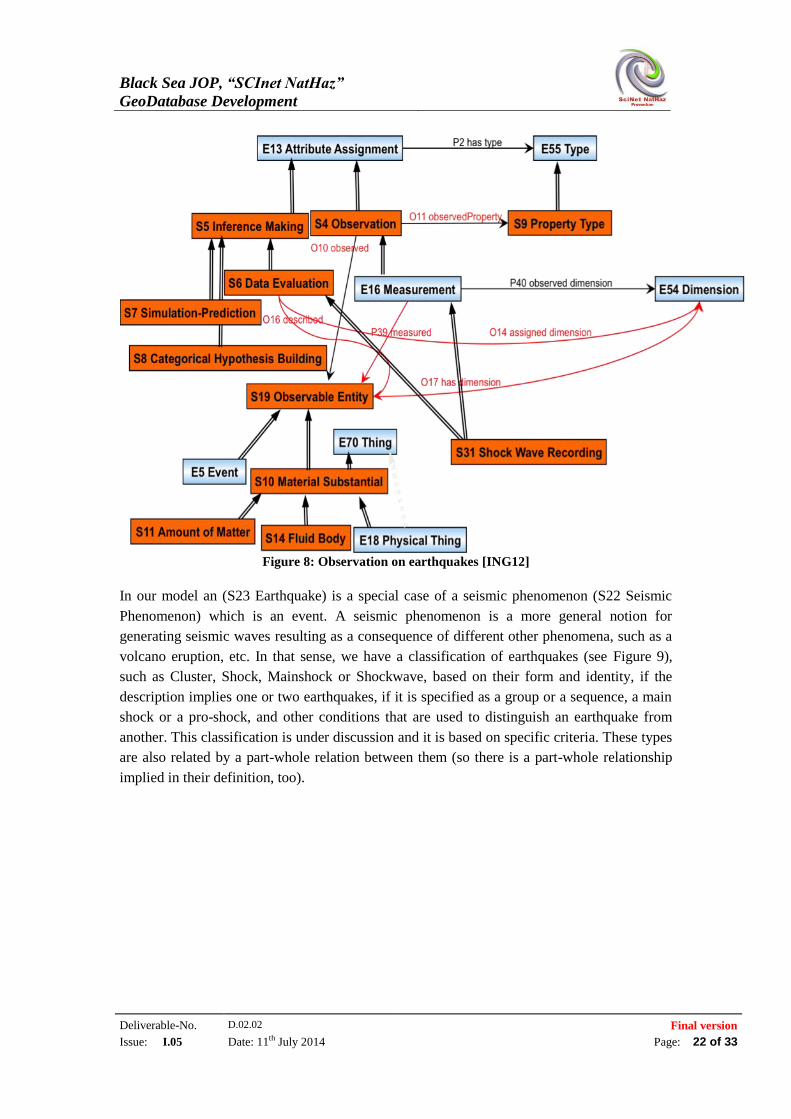
3.4 THEME 2: SEISMIC CORE MODEL
The general core observation model can also be used for describing fuzzy large scale power
natural phenomena and destructive events such as seismic phenomena and earthquakes that
show features of observable seismic action and energy-related behavior (Figure 8). We use
two types of scientific assignments–approaches on these phenomena: a measurement event
(E16 Measurement) which is a kind of observation, in order to measure the magnitude of an
impact, and an S6 Data Evaluation event (a kind of Inference Making) for evaluations and
quantitative – qualitative observations on ground displacements and calculations used on
evaluating the measured data. Simulations - Predictions and Hypothesis building are other
types of making propositions about behavior and properties of real phenomena, which are
both based on theories and inference rules (but having different usage, e.g. for predictions).
Geodetic observation to tectonic motion, evaluation of dynamic properties of rock and
seismic hazard analysis involves repeated measurements.
Black Sea JOP, “SCInet NatHaz”
GeoDatabase Development
Deliverable-No. D.02.02 Final version
Issue: I.05 Date: 11th July 2014 Page: 22 of 33
Figure 8: Observation on earthquakes [ING12]
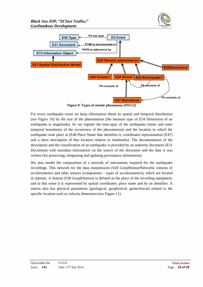
In our model an (S23 Earthquake) is a special case of a seismic phenomenon (S22 Seismic
Phenomenon) which is an event. A seismic phenomenon is a more general notion for
generating seismic waves resulting as a consequence of different other phenomena, such as a
volcano eruption, etc. In that sense, we have a classification of earthquakes (see Figure 9),
such as Cluster, Shock, Mainshock or Shockwave, based on their form and identity, if the
description implies one or two earthquakes, if it is specified as a group or a sequence, a main
shock or a pro-shock, and other conditions that are used to distinguish an earthquake from
another. This classification is under discussion and it is based on specific criteria. These types
are also related by a part-whole relation between them (so there is a part-whole relationship
implied in their definition, too).
Black Sea JOP, “SCInet NatHaz”
GeoDatabase Development
Deliverable-No. D.02.02 Final version
Issue: I.05 Date: 11th July 2014 Page: 23 of 33
Figure 9: Types of seismic phenomena [ING12]
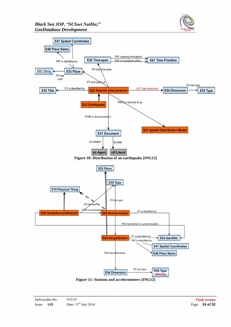
For every earthquake event we keep information about its spatial and temporal distribution
(see Figure 10) by the size of the phenomenon (the measure type of E54 Dimension of an
earthquake is magnitude). So we register the time-span of the earthquake (inner and outer
temporal boundaries of the occurrence of the phenomenon) and the location in which the
earthquake took place at (E48 Place Name that identifies it, coordinates representation (E47)
and a short description of that location relative to landmarks). The documentation of the
description and the classification of an earthquake is provided by an authority document (E31
Document) with metadata information on the source of the document and the date it was
written (for preserving, integrating and updating provenance information).
We also model the composition of a network of instruments required for the earthquake
recordings. This network for the data transmission (S28 GeophSensorNetwork) consists of
accelerometers and other sensors (components – types of accelerometers), which are located
in stations. A Station (S30 GeophStation) is defined as the place of the recording equipment,
and in that sense it is represented by spatial coordinates, place name and by an identifier. A
station also has physical parameters (geological, geophysical, geotechnical) related to the
specific location such as velocity dimension (see Figure 11).
Black Sea JOP, “SCInet NatHaz”
GeoDatabase Development
Deliverable-No. D.02.02 Final version
Issue: I.05 Date: 11th July 2014 Page: 24 of 33
Figure 10: Distribution of an earthquake [ING12]
Figure 11: Stations and accelerometers [ING12]
Black Sea JOP, “SCInet NatHaz”
GeoDatabase Development
Deliverable-No. D.02.02 Final version
Issue: I.05 Date: 11th July 2014 Page: 25 of 33
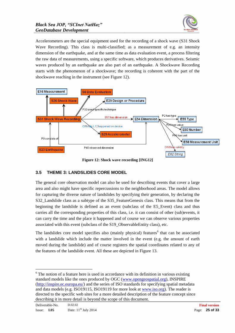
Accelerometers are the special equipment used for the recording of a shock wave (S31 Shock
Wave Recording). This class is multi-classified; as a measurement of e.g. an intensity
dimension of the earthquake, and at the same time as data evaluation event, a process filtering
the raw data of measurements, using a specific software, which produces derivatives. Seismic
waves produced by an earthquake are also part of an earthquake. A Shockwave Recording
starts with the phenomenon of a shockwave; the recording is coherent with the part of the
shockwave reaching in the instrument (see Figure 12).
Figure 12: Shock wave recording [ING12]
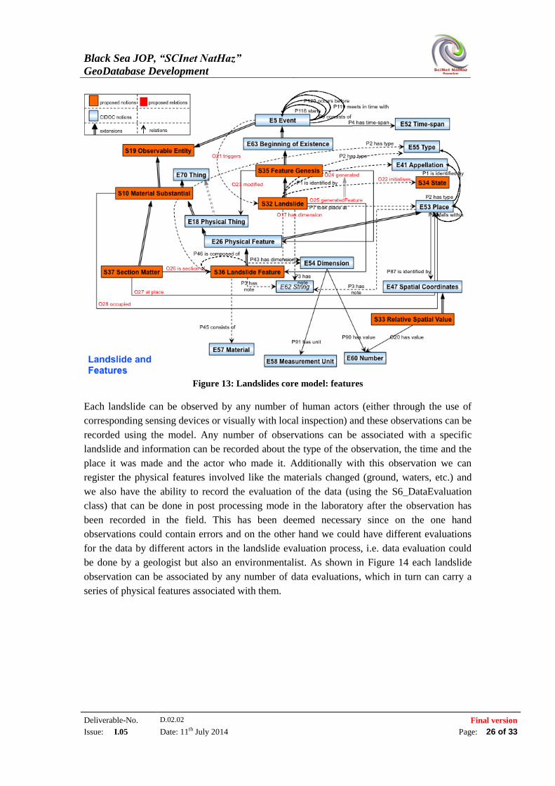
3.5 THEME 3: LANDSLIDES CORE MODEL
The general core observation model can also be used for describing events that cover a large
area and also might have specific repercussions to the neighborhood areas. The model allows
for capturing the diverse nature of landslides by specifying their generation, by declaring the
S32_Landslide class as a subtype of the S35_FeatureGenesis class. This means that from the
beginning the landslide is defined as an event (subclass of the E5_Event) class and thus
carries all the corresponding properties of this class, i.e. it can consist of other (sub)events, it
can carry the time and the place it happened and of course we can observe various properties
associated with this event (subclass of the S19_ObservableEntity class), etc.
The landslides core model specifies also (mainly physical) features6 that can be associated
with a landslide which include the matter involved in the event (e.g. the amount of earth
moved during the landslide) and of course registers the spatial coordinates related to any of
the features of the landslide event. All these are depicted in Figure 13.
6 The notion of a feature here is used in accordance with its definition in various existing
standard models like the ones produced by OGC (www.opengeospatial.org), INSPIRE
(http://inspire.ec.europa.eu/) and the series of ISO standards for specifying spatial metadata
and data models (e.g. ISO19115, ISO19119 for more look at www.iso.org). The reader is
directed to the specific web sites for a more detailed description of the feature concept since
describing it in more detail is beyond the scope of this document.
Black Sea JOP, “SCInet NatHaz”
GeoDatabase Development
Deliverable-No. D.02.02 Final version
Issue: I.05 Date: 11th July 2014 Page: 26 of 33
Figure 13: Landslides core model: features
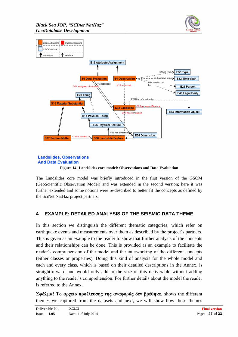
Each landslide can be observed by any number of human actors (either through the use of
corresponding sensing devices or visually with local inspection) and these observations can be
recorded using the model. Any number of observations can be associated with a specific
landslide and information can be recorded about the type of the observation, the time and the
place it was made and the actor who made it. Additionally with this observation we can
register the physical features involved like the materials changed (ground, waters, etc.) and
we also have the ability to record the evaluation of the data (using the S6_DataEvaluation
class) that can be done in post processing mode in the laboratory after the observation has
been recorded in the field. This has been deemed necessary since on the one hand
observations could contain errors and on the other hand we could have different evaluations
for the data by different actors in the landslide evaluation process, i.e. data evaluation could
be done by a geologist but also an environmentalist. As shown in Figure 14 each landslide
observation can be associated by any number of data evaluations, which in turn can carry a
series of physical features associated with them.
Black Sea JOP, “SCInet NatHaz”
GeoDatabase Development
Deliverable-No. D.02.02 Final version
Issue: I.05 Date: 11th July 2014 Page: 27 of 33
Figure 14: Landslides core model: Observations and Data Evaluation
The Landslides core model was briefly introduced in the first version of the GSOM
(GeoScientific Observation Model) and was extended in the second version; here it was
further extended and some notions were re-described to better fit the concepts as defined by
the SciNet NatHaz project partners.
4 EXAMPLE: DETAILED ANALYSIS OF THE SEISMIC DATA THEME
In this section we distinguish the different thematic categories, which refer on
earthquake events and measurements over them as described by the project’s partners.
This is given as an example to the reader to show that further analysis of the concepts
and their relationships can be done. This is provided as an example to facilitate the
reader’s comprehension of the model and the interworking of the different concepts
(either classes or properties). Doing this kind of analysis for the whole model and
each and every class, which is based on their detailed descriptions in the Annex, is
straightforward and would only add to the size of this deliverable without adding
anything to the reader’s comprehension. For further details about the model the reader
is referred to the Annex.
Σφάλμα! Το αρχείο προέλευσης της αναφοράς δεν βρέθηκε. shows the different
themes we captured from the datasets and next, we will show how these themes
Black Sea JOP, “SCInet NatHaz”
GeoDatabase Development
Deliverable-No. D.02.02 Final version
Issue: I.05 Date: 11th July 2014 Page: 28 of 33
correspond to specific usage examples of our General Core Model. In the following
pictures, we mapped the notions, which are used in the datasets on the corresponding
notions of the core model and created the sub - models for each category.
Table 1. Categories of the different concepts in the Seismic Model
Categories
Stations and Sensors Network
Earthquake Event
Seismic Recording
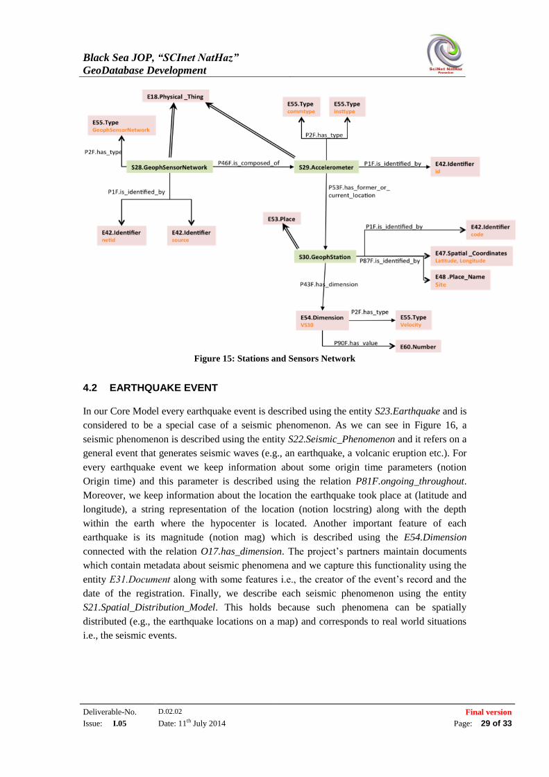
4.1 STATIONS AND SENSORS NETWORK
Seismic events are recorded by geophysical stations. We used the entity S30.GeophStation to
describe the stations and for each station we keep its location (Latitude, Longitude), its name
(notion Site) and we measure the shear-wave velocity between 0 and 30 meters depth (notion
VS30) (see Figure 15). Each station consists of sensors, which are the recording instruments
for earthquakes. Sensors are described using entity S29.Accelerometer and we used the
relation P53F.has_former_or_current_location to show that a sensor belongs in a station.
Each sensor has information about its communication type (analog or digital) using notion
commtype and a description of the instrument type (notion insttype). The available sensors
from a specific station constitute a network, which is described using the notion
S28.GeophSensorNetwork. Every network is identified by a network identifier string (notion
netid) and the agency that maintains each station (notion source).
Black Sea JOP, “SCInet NatHaz”
GeoDatabase Development
Deliverable-No. D.02.02 Final version
Issue: I.05 Date: 11th July 2014 Page: 29 of 33
Figure 15: Stations and Sensors Network
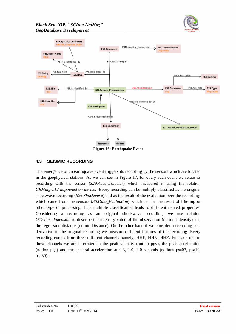
4.2 EARTHQUAKE EVENT
In our Core Model every earthquake event is described using the entity S23.Earthquake and is
considered to be a special case of a seismic phenomenon. As we can see in Figure 16, a
seismic phenomenon is described using the entity S22.Seismic_Phenomenon and it refers on a
general event that generates seismic waves (e.g., an earthquake, a volcanic eruption etc.). For
every earthquake event we keep information about some origin time parameters (notion
Origin time) and this parameter is described using the relation P81F.ongoing_throughout.
Moreover, we keep information about the location the earthquake took place at (latitude and
longitude), a string representation of the location (notion locstring) along with the depth
within the earth where the hypocenter is located. Another important feature of each
earthquake is its magnitude (notion mag) which is described using the E54.Dimension
connected with the relation O17.has_dimension. The project’s partners maintain documents
which contain metadata about seismic phenomena and we capture this functionality using the
entity Ε31.Document along with some features i.e., the creator of the event’s record and the
date of the registration. Finally, we describe each seismic phenomenon using the entity
S21.Spatial_Distribution_Model. This holds because such phenomena can be spatially
distributed (e.g., the earthquake locations on a map) and corresponds to real world situations
i.e., the seismic events.
Black Sea JOP, “SCInet NatHaz”
GeoDatabase Development
Deliverable-No. D.02.02 Final version
Issue: I.05 Date: 11th July 2014 Page: 30 of 33
Figure 16: Earthquake Event
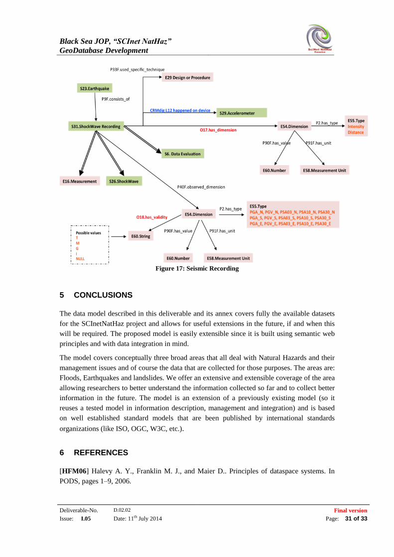
4.3 SEISMIC RECORDING
The emergence of an earthquake event triggers its recording by the sensors which are located
in the geophysical stations. As we can see in Figure 17, for every such event we relate its
recording with the sensor (S29.Accelerometer) which measured it using the relation
CRMdig:L12 happened on device. Every recording can be multiply classified as the original
shockwave recording (S26.Shockwave) and as the result of the evaluation over the recordings
which came from the sensors (S6.Data_Evaluation) which can be the result of filtering or
other type of processing. This multiple classification leads to different related properties.
Considering a recording as an original shockwave recording, we use relation
O17.has_dimension to describe the intensity value of the observation (notion Intensity) and
the regression distance (notion Distance). On the other hand if we consider a recording as a
derivative of the original recording we measure different features of the recording. Every
recording comes from three different channels namely, HHE, HHN, HHZ. For each one of
these channels we are interested in the peak velocity (notion pgv), the peak acceleration
(notion pga) and the spectral acceleration at 0.3, 1.0, 3.0 seconds (notions psa03, psa10,
psa30).
Black Sea JOP, “SCInet NatHaz”
GeoDatabase Development
Deliverable-No. D.02.02 Final version
Issue: I.05 Date: 11th July 2014 Page: 31 of 33
Figure 17: Seismic Recording
5 CONCLUSIONS
The data model described in this deliverable and its annex covers fully the available datasets
for the SCInetNatHaz project and allows for useful extensions in the future, if and when this
will be required. The proposed model is easily extensible since it is built using semantic web
principles and with data integration in mind.
The model covers conceptually three broad areas that all deal with Natural Hazards and their
management issues and of course the data that are collected for those purposes. The areas are:
Floods, Earthquakes and landslides. We offer an extensive and extensible coverage of the area
allowing researchers to better understand the information collected so far and to collect better
information in the future. The model is an extension of a previously existing model (so it
reuses a tested model in information description, management and integration) and is based
on well established standard models that are been published by international standards
organizations (like ISO, OGC, W3C, etc.).
6 REFERENCES
[HFM06] Halevy A. Y., Franklin M. J., and Maier D.. Principles of dataspace systems. In
PODS, pages 1–9, 2006.
Black Sea JOP, “SCInet NatHaz”
GeoDatabase Development
Deliverable-No. D.02.02 Final version
Issue: I.05 Date: 11th July 2014 Page: 32 of 33
[PCF+12] Paton N., Christodoulou K., Fernandes A. Parsia B., Hedeler C.: Pay-as-you-go
Data Integration for Linked Data: opportunities, challenges and architectures. In SWIM 2012,
May 20, 2012, Scottsdale, Arizona, USA.
[MCD+07] Madhavan, J., Cohen, S., Dong, X.L., Halevy, A.Y., Jeffery, S.R., Ko, D., Yu, C.:
Web-scale data integration: You can afford to pay as you go. In: CIDR'07. (2007) 342 – 350
[JFH08] Jeffery, S.R., Franklin, M.J., Halevy, A.Y.: Pay-as-you-go user feedback for
dataspace systems. In: SIGMOD'08, ACM (2008) 847 - 860
[DS2006] Dittrich, J.P., Salles, M.A.V.: idm: A unified and versatile data model for personal
dataspace management. In: VLDB'06, ACM (2006) 367 - 378
[FHM05] Franklin, M., Halevy, A., Maier, D.: From databases to dataspaces: a new
abstraction for information management. SIGMOD Record 34(4) (2005) 27 - 33
[HFM06] Halevy, A., Franklin, M., Maier, D.: Principles of dataspace systems. In: PODS'06,
ACM (2006) 1 - 9
[SDH08] Das Sarma, A., Dong, X., Halevy, A.: Bootstrapping pay-as-you-go data integration
systems. In: SIGMOD'08, ACM (2008) 861 – 874
[BFM05] Berners-Lee T., Fielding R., Masinter L.: Uniform Resource Identifiers (URI):
generic syntax. January 2005. Internet RFC 3986. URL: http://www.ietf.org/rfc/rfc3986.txt
[DS06] Duerst M., Suignard M.: Internationalized Resource Identifiers (IRI). January 2005.
Internet RFC 3987. URL: http://www.ietf.org/rfc/rfc3987.txt
[TSS11] Tschirner S., Scherp A., Staab S.: Semantic access to INSPIRE, How to publish and
query advanced GML data. The 10th Internation Semnatic Web Conference, 23 – 27 October
2011, Bonn, Germany (2011).
[ING12] InGeoCloudS Consortium: Interface of web services and models of data, D2.2,
Version 1.0, Avaiable at: http://www.ingeoclouds.eu/sites/default/files/D2.2-INGC-
IntfWSandDatamodels-V1-Approved_0.pdf
[CID11] ICOM/CIDOC Documentation Standards Group; & CIDOC CRM Special Interest
Group.: Official Version of the CIDOC CRM, the version 5.0.4 of the reference
document. Nick Crofts, Martin Doerr, Tony Gill, Stephen Stead, Matthew Stiff
(editors): Definition of the CIDOC Conceptual Reference Model, December 2011. Available
online at
http://www.cidoc-crm.org/docs/cidoc_crm_version_5.0.4.doc

Black Sea JOP, “SCInet NatHaz”
GeoDatabase Development
Deliverable-No. D.02.02 Final version
Issue: I.05 Date: 11th July 2014 Page: 33 of 33
7 ANNEX I – DETAILED DESCRIPTION OF THE (GEOSCIENTIFIC
OBSERVATION) CONCEPTUAL MODEL