Embed Size (px)
Citation preview
6th GEO European Projects Workshop, CNR, Rome, 7 – 8 May 2012
Michael Nyenhuis
with contributions from
D. Cripe, GEO Secretariat
R. Lawford, IGWCO
GEO European Projects Workshop 2012
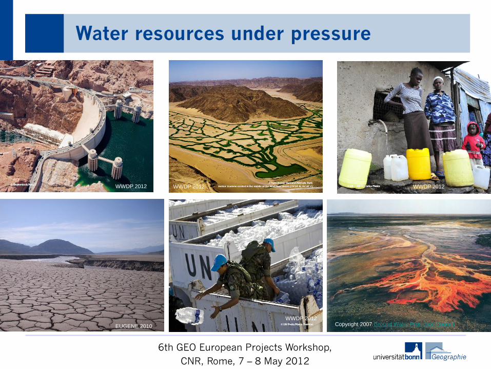
Water resources under pressure
6th GEO European Projects Workshop,
CNR, Rome, 7 – 8 May 2012
Copyright 2007 Ground Water Protection Council
WWDP 2012 WWDP 2012 WWDP 2012
WWDP 2012
EUGENE 2010
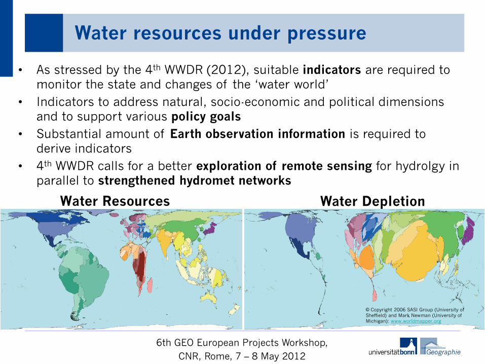
Water Resources
Water resources under pressure
6th GEO European Projects Workshop,
CNR, Rome, 7 – 8 May 2012
Water Depletion
© Copyright 2006 SASI Group (University of
Sheffield) and Mark Newman (University of
Michigan): www.worldmapper.org
• As stressed by the 4th WWDR (2012), suitable indicators are required to
monitor the state and changes of the ‘water world’
• Indicators to address natural, socio-economic and political dimensions
and to support various policy goals
• Substantial amount of Earth observation information is required to
derive indicators
• 4th WWDR calls for a better exploration of remote sensing for hydrolgy in
parallel to strengthened hydromet networks
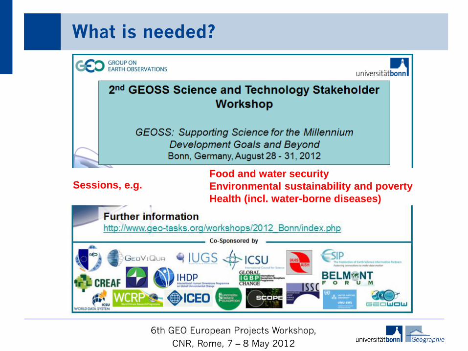
What is needed?
6th GEO European Projects Workshop,
CNR, Rome, 7 – 8 May 2012
• Research to improve knowledge of the water cycle
• Transfer of research results into usable information for
decision-making and to support policy goals
• Sustained Earth observation systems that acquire necessary
water cycle data and make this data available in an
interoperable manner
– Integration of Earth observations from different sources (in-situ
networks, remote sensing systems and models), including innovative
observation technologies, into new, high-quality products
– Exploitation of new technologies and social media to make data and
information more accessible and usable
• Facilitate the dialogue with Earth observation stakeholders
Sessions, e.g. Food and water security
Environmental sustainability and poverty
Health (incl. water-borne diseases)
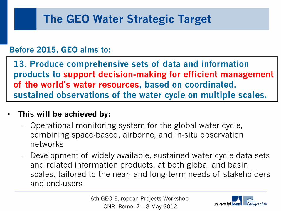
The GEO Water Strategic Target
6th GEO European Projects Workshop,
CNR, Rome, 7 – 8 May 2012
• This will be achieved by:
– Operational monitoring system for the global water cycle,
combining space-based, airborne, and in-situ observation
networks
– Development of widely available, sustained water cycle data sets
and related information products, at both global and basin
scales, tailored to the near- and long-term needs of stakeholders
and end-users
Before 2015, GEO aims to:
13. Produce comprehensive sets of data and information products to support decision-making for efficient management of the world's water resources, based on coordinated, sustained observations of the water cycle on multiple scales.

6th GEO European Projects Workshop,
CNR, Rome, 7 – 8 May 2012
• Task components
– C1: Integrated Water-cycle Products and Services
– C2: Information Systems for Hydro-meteorological Extremes (incl.
Floods & Droughts)
– C3: Information Service for Cold Regions
– C4: Global Water-Quality Products and Services
– C5: Information System Development and Capacity Building
WA-01: Integrated Water Cycle Information (incl. Floods and Droughts)
Improving water-resource management through better understanding of
the water cycle
The GEO Water Task (WP 2012-2015)

Leads: Japan (University of Tokyo), Nigeria (NASRDA), USA (Morgan State University, NASA, USGS), CEOS, ESA, WMO
• Reliable global precipitation datasets (GMES In-situ Component, Virtual Constellations, GPM)
• Improve global evapotranspiration products for different regions
• Develop a global soil-moisture product and service for climate and water management
• Integrate dedicated river gauging networks into a global runoff observation network
• Establish a Global Groundwater Monitoring Network (GGMN)
• Deliver integrated data sets from the Great Lakes basin
• Develop a GEOSS Water Cycle Integrator (WCI) to provide holistic coordination of water cycle information
• Develop end-to-end state of the water-cycle indicators
6th GEO European Projects Workshop,
CNR, Rome, 7 – 8 May 2012
The GEO Water Task (WP 2012-2015)
C1: Integrated Water-cycle Products and Services
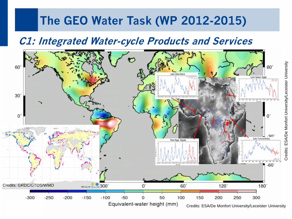
The GEO Water Task (WP 2012-2015)
C1: Integrated Water-cycle Products and Services
6th GEO European Projects Workshop,
CNR, Rome, 7 – 8 May 2012
Credits: ESA/De Monfort University/Leceister University
Credits: GRDC/GTOS/WMO
Cre
dits: E
SA
/De M
onfo
rt U
niv
ers
ity/L
eceis
ter
Univ
ers
ity
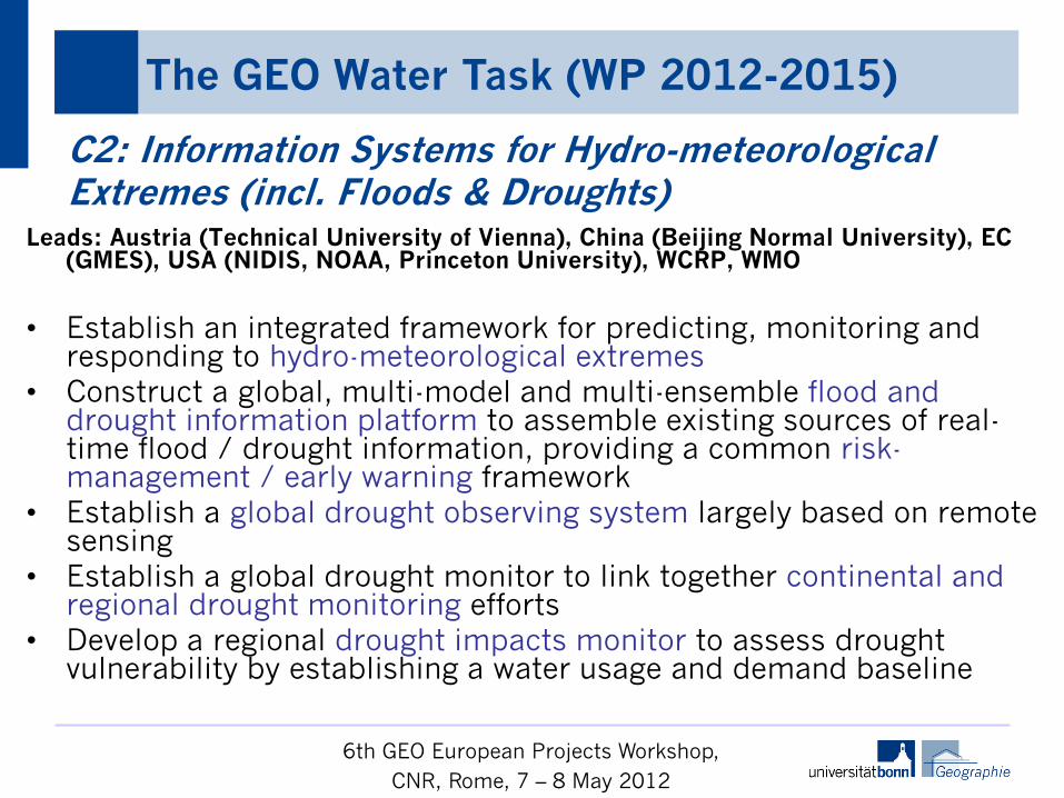
Leads: Austria (Technical University of Vienna), China (Beijing Normal University), EC (GMES), USA (NIDIS, NOAA, Princeton University), WCRP, WMO
• Establish an integrated framework for predicting, monitoring and responding to hydro-meteorological extremes
• Construct a global, multi-model and multi-ensemble flood and drought information platform to assemble existing sources of real-time flood / drought information, providing a common risk-management / early warning framework
• Establish a global drought observing system largely based on remote sensing
• Establish a global drought monitor to link together continental and regional drought monitoring efforts
• Develop a regional drought impacts monitor to assess drought vulnerability by establishing a water usage and demand baseline
6th GEO European Projects Workshop,
CNR, Rome, 7 – 8 May 2012
C2: Information Systems for Hydro-meteorological Extremes (incl. Floods & Droughts)
The GEO Water Task (WP 2012-2015)
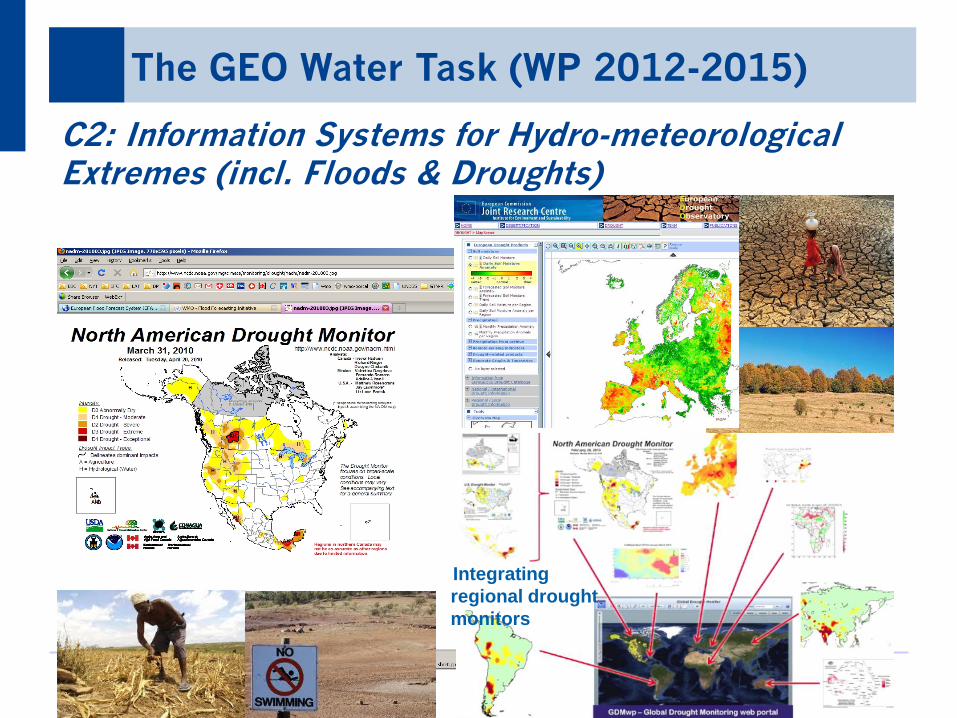
C2: Information Systems for Hydro-meteorological Extremes (incl. Floods & Droughts)
The GEO Water Task (WP 2012-2015)
6th GEO European Projects Workshop,
CNR, Rome, 7 – 8 May 2012
Integrating
regional drought
monitors

Leads: Canada (University of Waterloo), China (Beijing Normal University), Switzerland (WGMS), USA (NASA, NOAA, NSIDC), IEEE, WMO
• Support glacier monitoring, building upon the work of GLIMS, GlobGlacier, and the National Snow and Ice Data Center.
• Archive, manage, and provide access to data measuring frozen ground, glaciers, ice sheets, sea ice, and snow.
• Build a polar data catalogue through integrated observation and modelling data from the broad range of “International Polar Year” research activities
• Support the development of sustained and coordinated pan-Arctic observing and systems that serve societal needs (WMO Global Cryosphere Watch)
• Improve networking among existing observing systems and data sharing sites to create pan-Arctic observing networks
• Establish a Cryosphere Constellation by linking existing and proposed portals of cryospheric information, such as the Polar Data Catalogue, National Snow and Ice Data Centre, and SAON.
6th GEO European Projects Workshop,
CNR, Rome, 7 – 8 May 2012
C3: Information Service for Cold Regions
The GEO Water Task (WP 2012-2015)
Leads: Australia (CSIRO), Estonia (University of Tartu), Germany (University of Bonn), South Africa (CSIR), USA (EPA, NASA, WDNR), UNEP, WHO
• Develop improved Earth observation derived water-quality datasets through algorithm development, atmospheric correction and standardization of data processing and products
• Conduct demonstration projects on the value of Earth observations for water quality management (e.g. expanding the ChloroGIN project)
• Develop a riverine water-quality data assimilation system primarily based on in-situ water quality data from the GEMS/Water archive and constituent transport models. Develop integrative hydrologic/water-quality models focused on sediment and nutrients
• Scope water-quality information systems to collate, manage and provide public access to international water-quality datasets.
• Coordinate efforts of the water-quality community, working with other GEO communities such as Oceans, Health and Biodiversity (related freshwater ecosystems)
6th GEO European Projects Workshop,
CNR, Rome, 7 – 8 May 2012
C4: Global Water-Quality Products and Services
The GEO Water Task (WP 2012-2015)
Leads: Canada (IISD), Japan (University of Tokyo), USA (University of Maryland, NOAA, USAID), ESA, IEEE, UNESCO
• Latin & Caribbean Americas: Program for water-resource management to support the development of infrastructure, decision-support-systems, and training/research applied to the use of Earth observations
• Asia, Africa, L&CA: Competencies among water management practitioners, researchers, and administrators through demonstration projects
• Asia, Africa: Develop information systems based on open-source software infrastructure to promote integrated water resources management (IWRM), transboundary river basin management, and water information sharing
• Africa: Support the African Water Cycle Coordination Initiative (AfWCCI) to develop an independent water management capacity and sustainable water observing networks (build upon TIGER, GMES Africa, SERVIR, etc.)
• Conduct pilot projects for improved water discovery and quality in cooperation with local, regional, and national groups
6th GEO European Projects Workshop,
CNR, Rome, 7 – 8 May 2012
C5: Information System Development and Capacity Building
The GEO Water Task (WP 2012-2015)
6th GEO European Projects Workshop,
CNR, Rome, 7 – 8 May 2012
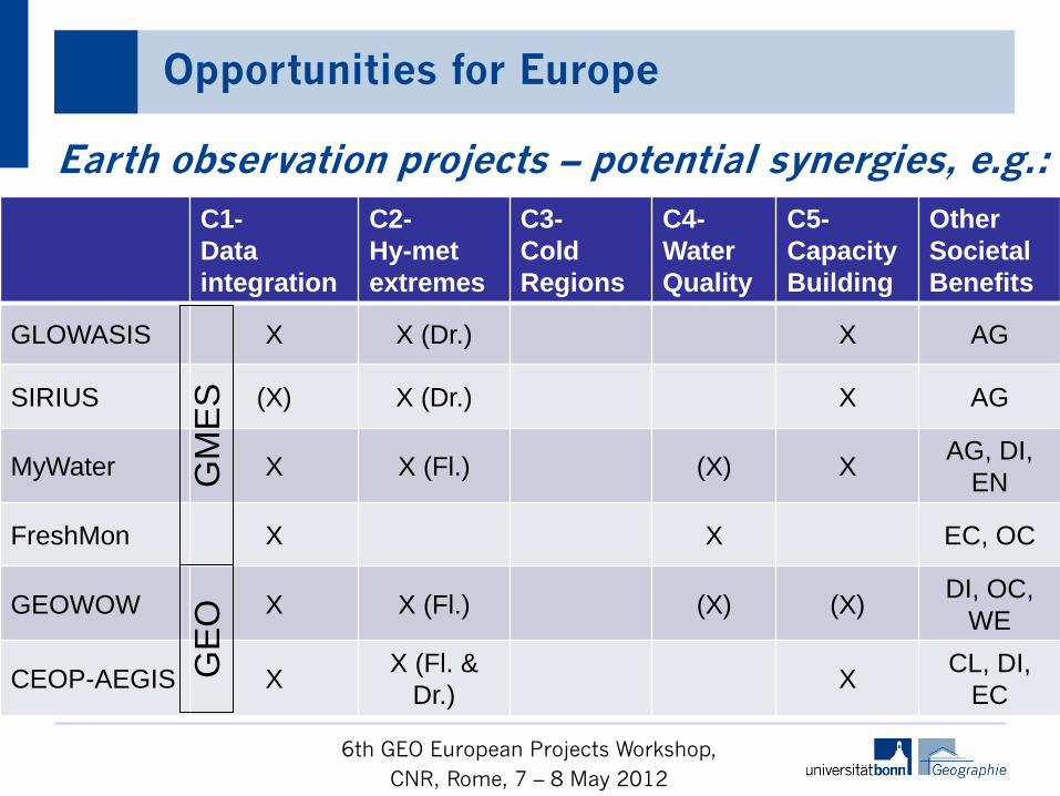
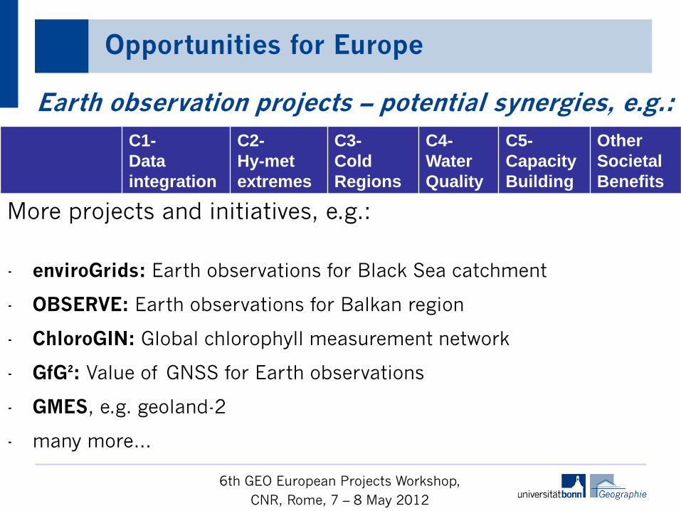
Earth observation projects – potential synergies, e.g.:
C1-
Data
integration
C2-
Hy-met
extremes
C3-
Cold
Regions
C4-
Water
Quality
C5-
Capacity
Building
Other
Societal
Benefits
GLOWASIS X X (Dr.) X AG
SIRIUS (X) X (Dr.) X AG
MyWater X X (Fl.) (X) X AG, DI,
EN
FreshMon X X EC, OC
GEOWOW X X (Fl.) (X) (X) DI, OC,
WE
CEOP-AEGIS X X (Fl. &
Dr.) X
CL, DI,
EC
Opportunities for Europe
GM
ES
G
EO
6th GEO European Projects Workshop,
CNR, Rome, 7 – 8 May 2012
Earth observation projects – potential synergies, e.g.:
C1-
Data
integration
C2-
Hy-met
extremes
C3-
Cold
Regions
C4-
Water
Quality
C5-
Capacity
Building
Other
Societal
Benefits
GLOWASIS X X (Dr.) X AG
SIRIUS (X) X (Dr.) X AG
MyWater X X (Fl.) (X) X AG, DI,
EN
FreshMon X X EC, OC
GEOWOW X X (Fl.) (X) (X) DI, OC,
WE
CEOP-AEGIS X X (Fl. &
Dr.) X
CL, DI,
EC
Opportunities for Europe
GM
ES
G
EO
More projects and initiatives, e.g.:
- enviroGrids: Earth observations for Black Sea catchment
- OBSERVE: Earth observations for Balkan region
- ChloroGIN: Global chlorophyll measurement network
- GfG²: Value of GNSS for Earth observations
- GMES, e.g. geoland-2
- many more…
6th GEO European Projects Workshop,
CNR, Rome, 7 – 8 May 2012
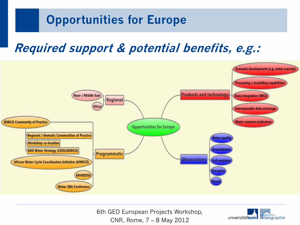
Required support & potential benefits, e.g.:
Opportunities for Europe
IGWCO Annual Meeting, Kona, Hawaii, 22-24 Feb 2012
Thank you ! Michael Nyenhuis
Department of Geography, University of Bonn
www.gymnasium-luechow.de

FP7 Cooperation and Support Action (CSA), 2009-2011
6th GEO European Projects Workshop,
CNR, Rome, 7 – 8 May 2012
Reports available at www.eugene-fp7.eu
Opportunities for Europe
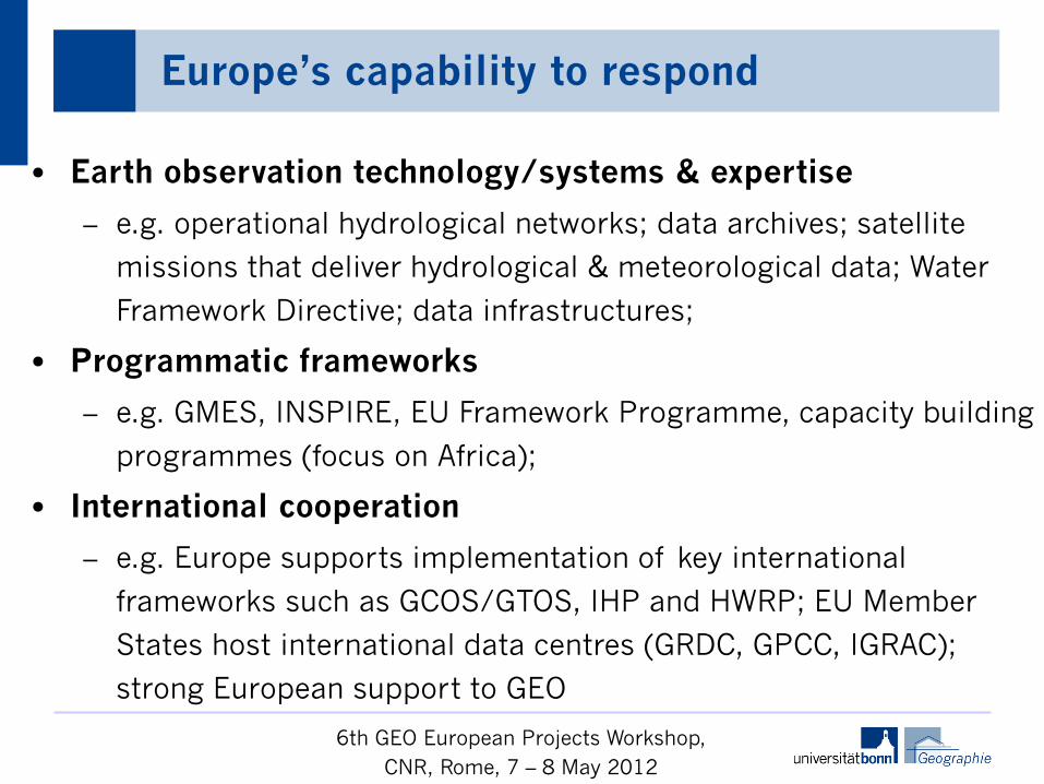
Europe’s capability to respond
6th GEO European Projects Workshop,
CNR, Rome, 7 – 8 May 2012
• Earth observation technology/systems & expertise
– e.g. operational hydrological networks; data archives; satellite
missions that deliver hydrological & meteorological data; Water
Framework Directive; data infrastructures;
• Programmatic frameworks
– e.g. GMES, INSPIRE, EU Framework Programme, capacity building
programmes (focus on Africa);
• International cooperation
– e.g. Europe supports implementation of key international
frameworks such as GCOS/GTOS, IHP and HWRP; EU Member
States host international data centres (GRDC, GPCC, IGRAC);
strong European support to GEO
Europe’s capability to respond
6th GEO European Projects Workshop,
CNR, Rome, 7 – 8 May 2012
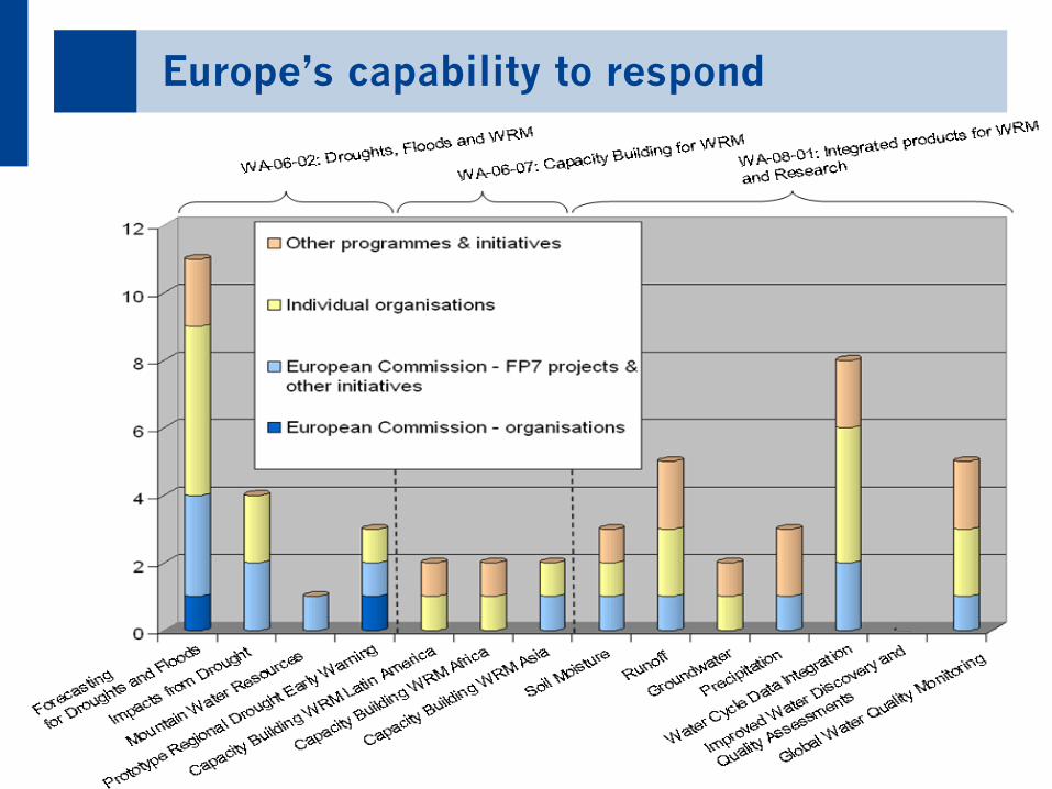
• Europe has been broadly represented in the Water Tasks of
the 2009-2011 Work Plan
• Mainly FP7 projects, national, EU level and international
organizations
• Four Tasks with strong European participation:
– WA-06-01a: Forecasting for Droughts and Floods – 11 participants
– WA-08-01e: Water Cycle Data Integration – 8 participants
– WA-08-01b: Runoff – 5 participants
– WA-08-01g: Global Water Quality Monitoring – 5 participants
European contributions to GEO Water (09/11)