Embed Size (px)
Citation preview
1239
Genetic, Morphological, and Statistical Characterization of Lakes in the
Permafrost-Dominated Lena Delta
Anne Morgenstern
Alfred Wegener Institute for Polar and Marine Research, Research Unit Potsdam, Potsdam, Germany
Guido Grosse
Geophysical Institute, University of Alaska Fairbanks, Fairbanks, Alaska, USA
Lutz Schirrmeister
Alfred Wegener Institute for Polar and Marine Research, Research Unit Potsdam, Potsdam, Germany
Abstract
This study provides a detailed inventory of lakes in the Lena Delta, northern Siberia. The inventory is based on
Landsat-7 ETM+ image data and spatial analysis in a Geographical Information System (GIS). Several morphometric
lake attributes were determined from the resulting dataset and statistically analyzed with respect to the lakes’ association
with one of the three geomorphological main terraces of the Lena Delta. Significant differences in the morphometric
lake characteristics allowed the distinction of a mean lake type for each main terrace. The lake types reflect the special
lithological and cryolithological conditions and geomorphological processes prevailing on each terrace. Special focus
was laid on the investigation of lake orientation and the discussion of possible mechanisms for the evolution of the
second terrace’s oriented lakes.
Keywords: GIS; lake morphometry; Lena Delta; oriented lakes; remote sensing; thermokarst lakes.
Introduction
Numerous lakes occur as characteristic landforms
throughout the Lena Delta. They are of importance to the
contemporary ecology and geomorphology in this sensitive
Arctic environment as well as for the reconstruction of the
delta’s environmental history. So far, only general descriptions
of the lake population were available (e.g., Grigoriev 1993).
They suggest that several lake types of different genesis can
be distinguished and that the western delta is characterized
by oriented lakes. However, a detailed inventory of the Lena
Delta lakes did not exist. Such an inventory potentially
provides a base dataset essential to a variety of research
conducted in this region. This study was aimed to create
a lake dataset of the Lena Delta including morphometric
and spatial characteristics using remote sensing and GIS
techniques to analyze the dataset regarding a morphometric
lake classification, and to investigate possible hypotheses
of the morphogenesis of the lakes in this periglacial delta
environment.
Regional Setting
The Lena Delta in northern Siberia is the largest Arctic
river delta (Walker 1998). It is situated in the zone of
continuous permafrost and is widely affected by thermokarst.
It is characterized not only by alluvial sediments and active
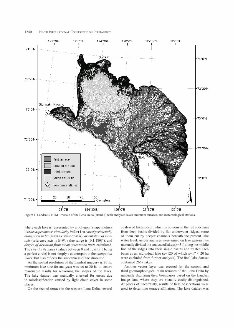
fluvial processes, but also by large non-deltaic units. Three
main terraces can be distinguished by their geomorphology
(e.g., Are & Reimnitz 2000, Schwamborn et al. 2002)
(Fig. 1). The first main terrace, which represents the modern
active delta, is comprised of the lower and upper floodplains
and the first terrace above the floodplain. It forms most of the
eastern Lena Delta and is characterized by alluvial Holocene
sands with silts and peat. The second terrace captures
broad parts of the western Lena Delta. It consists of Late
Pleistocene to Early Holocene sands of fluvial genesis, but
is hardly influenced by modern fluvial processes. The third
main terrace is the relic of a Late Pleistocene accumulation
plain with fine-grained and ice-rich deposits.
Materials and Methods
Remote sensing
A mosaic of three Landsat-7 ETM+ scenes taken in the
summers 2000 and 2001 covering 98 % of the Lena delta
(Schneider et al., in prep.) was used as a basis for lake
extraction using the software ENVITM 4.1. First, we conducted
a gray-level thresholding on the mid-IR band 5 to separate
open water from land, as water bodies are strong absorbers
in these wavelengths and easily distinguishable from other
land cover classes. Second, the water class was subjected to a
segmentation algorithm to differentiate standing water from
rivers and the sea. This method creates separate classes for
coherent pixels with the same value. As rivers and estuaries
are connected with the sea, they form one single class and
were deleted. Some lakes along the coastline that have broad
(in the range of several pixels) connections to the sea were
thereby also removed from the dataset. They experience a
strong marine influence; for example, during storm floods,
which can lead to major changes in lake morphometry and
lagoon formation. Thus, these lakes were not considered for
morphometric and further analysis.
GIS and morphometric analysis
The resulting raster dataset of all remaining lakes was
imported into ArcGISTM 9.0 and converted into vector format
1240 NINTH INTERNATIONAL CONFERENCE ON PERMAFROST
where each lake is represented by a polygon. Shape metrics
like area, perimeter, circularity index (4×π×area/perimeter²),
elongation index (main axis/minor axis), orientation of main
axis (reference axis is E-W, value range is [0.1;180]°), and
degree of deviation from mean orientation were calculated.
The circularity index (values between 0 and 1, with 1 being
a perfect circle) is not simply a counterpart to the elongation
index, but also reflects the smoothness of the shoreline.
As the spatial resolution of the Landsat imagery is 30 m,
minimum lake size for analyses was set to 20 ha to ensure
reasonable results for reckoning the shapes of the lakes.
The lake dataset was manually checked for errors due
to misclassification caused by light cloud cover in some
places.
On the second terrace in the western Lena Delta, several
coalesced lakes occur, which is obvious in the red spectrum
from deep basins divided by flat underwater ridges, some
of them cut by deeper channels beneath the present lake
water level. As our analyses were aimed on lake genesis, we
manually divided the coalesced lakes (n=51) along the middle
line of the ridges into their single basins and treated each
basin as an individual lake (n=120 of which n=17 < 20 ha
were excluded from further analysis). The final lake dataset
contained 2669 lakes.
Another vector layer was created for the second and
third geomorphological main terraces of the Lena Delta by
manually digitizing their boundaries based on the Landsat
image data, where they are visually easily distinguished.
At places of uncertainty, results of field observations were
used to determine terrace affiliation. The lake dataset was
Figure 1. Landsat-7 ETM+ mosaic of the Lena Delta (Band 2) with analyzed lakes and main terraces, and meteorological stations.
MORGENSTERN, GROSSE, AND SCHIRRMEISTER 1241
then divided into three subgroups according to the lakes’
association with one of the geomorphological main terraces.
The subgroup for the first terrace lakes was created by
subtraction of the second and third terrace lakes from the
whole lake population.
The variables described above were statistically analyzed
for these subgroups using the software SPSSTM 12.0.
Several statistics were calculated for the variables within an
explorative data analysis (EDA). Variables were tested for
normal distribution using the Kolmogorov-Smirnov test and
for homogeneity of variance using the Levene test. In case
of non-normal distribution skewness was minimized by data
transformation and subsequent tests were performed with
the transformed data. To test significant differences in the
means of the variables between the three terraces analysis of
variance (ANOVA) was performed. Non-parametric Median
test and Kruskal-Wallis test (rank-based) were used with the
non-transformed data for validation. Furthermore, multiple
comparative tests (Games-Howell) were applied to identify
terraces between which significant differences in the mean
values occur at the 5% level. Bivariate correlations were
calculated for the variables area, circularity, elongation, and
degree of deviation from mean orientation using the rank-
based Spearman’s Rho correlation coefficient.
Results
The total area of lakes ≥ 20 ha is 1861.8 km², which
corresponds to 6.4 % of the delta area, as the delta area within
the extent of the mosaic was calculated to be 29,000 km²
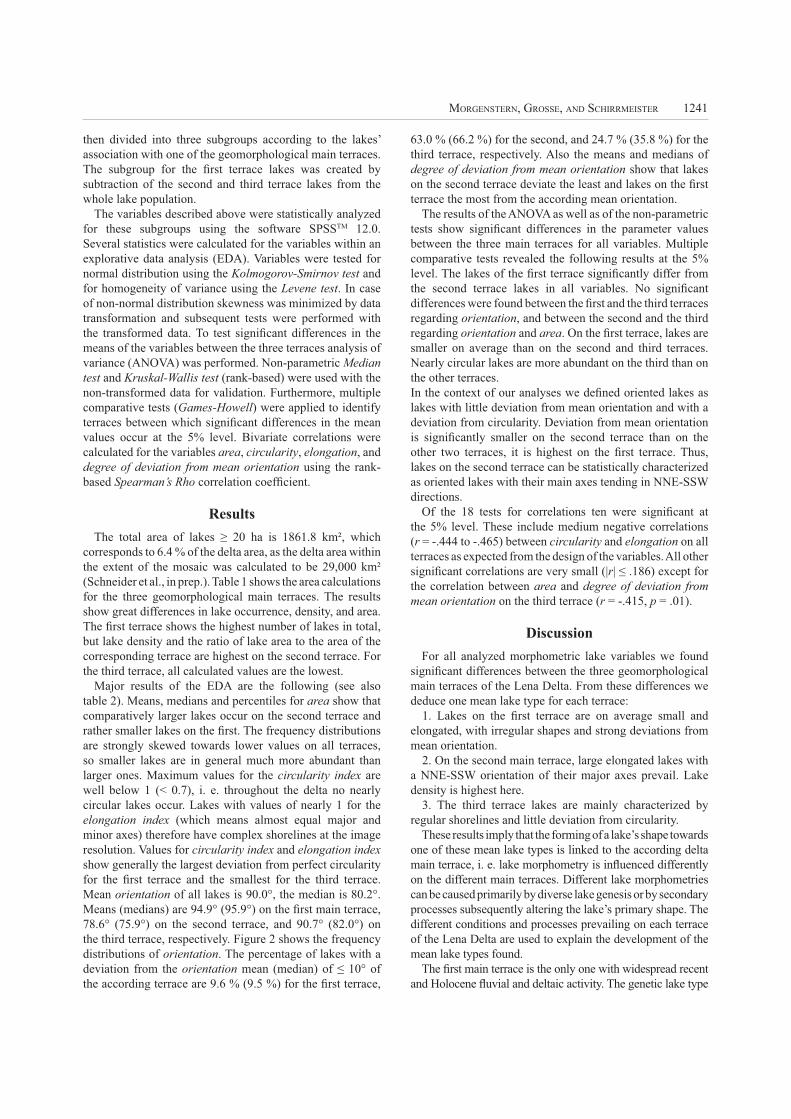
(Schneider et al., in prep.). Table 1 shows the area calculations
for the three geomorphological main terraces. The results
show great differences in lake occurrence, density, and area.
The first terrace shows the highest number of lakes in total,
but lake density and the ratio of lake area to the area of the
corresponding terrace are highest on the second terrace. For
the third terrace, all calculated values are the lowest.
Major results of the EDA are the following (see also
table 2). Means, medians and percentiles for area show that
comparatively larger lakes occur on the second terrace and
rather smaller lakes on the first. The frequency distributions
are strongly skewed towards lower values on all terraces,
so smaller lakes are in general much more abundant than
larger ones. Maximum values for the circularity index are
well below 1 (< 0.7), i. e. throughout the delta no nearly
circular lakes occur. Lakes with values of nearly 1 for the
elongation index (which means almost equal major and
minor axes) therefore have complex shorelines at the image
resolution. Values for circularity index and elongation index
show generally the largest deviation from perfect circularity
for the first terrace and the smallest for the third terrace.
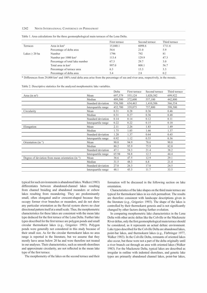
Mean orientation of all lakes is 90.0°, the median is 80.2°.
Means (medians) are 94.9° (95.9°) on the first main terrace,
78.6° (75.9°) on the second terrace, and 90.7° (82.0°) on
the third terrace, respectively. Figure 2 shows the frequency
distributions of orientation. The percentage of lakes with a
deviation from the orientation mean (median) of ≤ 10° of
the according terrace are 9.6 % (9.5 %) for the first terrace,
63.0 % (66.2 %) for the second, and 24.7 % (35.8 %) for the
third terrace, respectively. Also the means and medians of
degree of deviation from mean orientation show that lakes
on the second terrace deviate the least and lakes on the first
terrace the most from the according mean orientation.
The results of the ANOVA as well as of the non-parametric
tests show significant differences in the parameter values
between the three main terraces for all variables. Multiple
comparative tests revealed the following results at the 5%
level. The lakes of the first terrace significantly differ from
the second terrace lakes in all variables. No significant
differences were found between the first and the third terraces
regarding orientation, and between the second and the third
regarding orientation and area. On the first terrace, lakes are
smaller on average than on the second and third terraces.
Nearly circular lakes are more abundant on the third than on
the other terraces.
In the context of our analyses we defined oriented lakes as
lakes with little deviation from mean orientation and with a
deviation from circularity. Deviation from mean orientation
is significantly smaller on the second terrace than on the
other two terraces, it is highest on the first terrace. Thus,
lakes on the second terrace can be statistically characterized
as oriented lakes with their main axes tending in NNE-SSW
directions.
Of the 18 tests for correlations ten were significant at
the 5% level. These include medium negative correlations
(r = -.444 to -.465) between circularity and elongation on all
terraces as expected from the design of the variables. All other
significant correlations are very small (|r| ≤ .186) except for
the correlation between area and degree of deviation from
mean orientation on the third terrace (r = -.415, p = .01).
Discussion
For all analyzed morphometric lake variables we found
significant differences between the three geomorphological
main terraces of the Lena Delta. From these differences we
deduce one mean lake type for each terrace:
1. Lakes on the first terrace are on average small and
elongated, with irregular shapes and strong deviations from
mean orientation.
2. On the second main terrace, large elongated lakes with
a NNE-SSW orientation of their major axes prevail. Lake
density is highest here.
3. The third terrace lakes are mainly characterized by
regular shorelines and little deviation from circularity.
These results imply that the forming of a lake’s shape towards
one of these mean lake types is linked to the according delta
main terrace, i. e. lake morphometry is influenced differently
on the different main terraces. Different lake morphometries
can be caused primarily by diverse lake genesis or by secondary
processes subsequently altering the lake’s primary shape. The
different conditions and processes prevailing on each terrace
of the Lena Delta are used to explain the development of the
mean lake types found.
The first main terrace is the only one with widespread recent
and Holocene fluvial and deltaic activity. The genetic lake type
1242 NINTH INTERNATIONAL CONFERENCE ON PERMAFROST
typical for such environments is abandoned lakes. Walker (1983)
differentiates between abandoned-channel lakes resulting
from channel braiding and abandoned meanders or oxbow
lakes resulting from meandering. They are predominantly
small, often elongated and/or crescent-shaped because they
occupy former river branches or meanders, and do not show
any particular orientation as the fluvial system shows no clear
directional pattern itself at a small scale. Thus, the morphometric
characteristics for these lakes are consistent with the mean lake
type deduced for the first terrace of the Lena Delta. Further lake
types described for the first terrace are polygon ponds and small
circular thermokarst lakes (e.g., Grigoriev 1993). Polygon
ponds were generally not considered in this study because of
their small size. As for the circular thermokarst lakes no area
range is reported in the literature, but we assume that they
mostly have areas below 20 ha and were therefore not treated
in our analyses. Their characteristics, such as smooth shorelines
and approximate circularity, are not reflected in the mean lake
type of the first terrace.
The morphometry of the lakes on the second terrace and their
formation will be discussed in the following section on lake
orientation.
Characteristics of the lake shapes on the third main terrace are
typical for thermokarst lakes in ice-rich permafrost. The results
are therefore consistent with landscape descriptions given in
the literature (e.g., Grigoriev 1993). The shape of the lakes is
controlled by their thermokarst genesis and is not significantly
changed by other factors during further evolution.
In comparing morphometric lake characteristics in the Lena
Delta with other arctic deltas like the Colville or the Mackenzie
River deltas, only the first geomorphological main terrace should
be considered, as it represents an actual deltaic environment.
Lake types described for the Colville Delta are abandoned lakes,
point-bar lakes, and thermokarst lakes (e.g., Fürbringer 1977,
Walker 1983). In the Colville Delta, remnants of oriented lakes
also occur, but these were not a part of the delta originally until
a river branch cut through an area with oriented lakes (Walker
1983). For the Mackenzie Delta, typical lakes are described as
irregular in outline with indented shorelines, and genetic lake
types are primarily abandoned channel lakes, point-bar lakes,
First terrace Second terrace Third terrace
Terraces Area in km² 15,840.1 6098.6 1711.6
Percentage of delta area 54.6 21.0 5.9
Lakes ≥ 20 ha Number 1796 792 81
Number per 1000 km² 113.4 129.9 47.3
Percentage of total lake number 67.3 29.7 3.0
Total area in km² 997.0 808.1 56.7
Percentage of terrace area 6.3 13.3 3.3
Percentage of delta area 3.4 2.8 0.2
Delta First terrace Second terrace Third terrace
Area (in m²) Mean 697,579 555,124 1,020,382 699,922
Median 409,500 372,600 557,100 442,800
Standard deviation 956,500 634,463 1,410,506 566,554
Interquartile range 452,700 339,075 757,800 598,500
Circularity Mean 0.31 0.28 0.36 0.46
Median 0.31 0.27 0.36 0.48
Standard deviation 0.14 0.14 0.12 0.11
Interquartile range 0.22 0.22 0.15 0.18
Elongation Mean 2.11 2.26 1.83 1.49
Median 1.75 1.85 1.66 1.37
Standard deviation 1.20 1.37 0.64 0.45
Interquartile range 0.92 1.12 0.55 0.36
Orientation (in °) Mean 90.0 94.9 78.6 90.8
Median 80.2 95.9 75.9 82.0
Standard deviation 47.1 54.3 21.4 38.2
Interquartile range 65.94 94.8 12.3 44.4
Degree of deviation from mean orientation (in °) Mean 38.6 47.5 12.9 29.1
Median 31.5 48.3 6.8 21.4
Standard deviation 27.0 26.3 17.0 24.5
Interquartile range 48.1 45.3 11.7 33.5
* Differences from 29,000 km² and 100% total delta area arise from the percentage of sea and river area, respectively, in the mosaic.
Table 1. Area calculations for the three geomorphological main terraces of the Lena Delta.
Table 2. Descriptive statistics for the analyzed morphometric lake variables.
MORGENSTERN, GROSSE, AND SCHIRRMEISTER 1243
floodplain lakes, and thermokarst lakes (Mackay 1963). Lake
types described for these deltas are thus comparable to the first
terrace lakes of the Lena Delta.
Lake orientation
The character of lake orientation as expressed by the variables
degree of deviation from mean orientation and circularity differs
significantly between the three main terraces as described
above. The process of lake orientation is long term and requires
stability of exogenous orienting factors. Active fluvial processes
prevailing on the first terrace may overlay tendencies of lake
orientation there. Existing discrepancies between the second
and the third terraces, however, must be discussed in detail.
Thermokarst lake evolution on both terraces reaches back
at least to the early Holocene warming period (Schirrmeister
et al. 2003, Schwamborn et al. 2002). Exogenous factors that
have been discussed as causing or influencing lake orientation;
for example, prevailing wind directions, solar radiation, etc.
(e.g., Livingstone 1954, Mackay 1956, Carson & Hussey
1959), therefore, have affected both terraces in the same way
for several thousand years. The different character of lake
orientation implies a dependence of further endogenous; i.e.,
terrace-specific factors.
Lithology and cryolithology of the second and third main
terraces differ considerably. Sediments on the second main
terrace are Late Pleistocene fluvial sediments that consist of
homogeneous fine- and medium-grained sands with massive
cryogene structures. Large ice wedges are absent, and the ground
ice content is generally rather low (15–25 wt%) (Schirrmeister
et al. 2007). The sediments are comparable to those in the North
American Arctic Coastal Plain where oriented lakes occur. The
homogeneity of the sands allows for a uniform distribution of
forces driving orientation processes. If these forces operate
directionally, orientation can clearly develop. Sediments on the
third main terrace, however, are mainly composed of the Yedoma
Suite, with peat, sands, and silts with high ground-ice content
(30–80 wt%) and inhomogeneous ice distribution (huge ice
wedges and intrapolygonal sediments with segregated ground
ice in the form of ice bands and small ice lenses) (Schirrmeister
et al. 2003). This heterogeneity prevents a continuous
distribution of external effects because of the different physical
characteristics of the sediments; for example, bulk density
or thermal conductivity. Orienting factors, therefore, cannot
operate uniformly, and the development of a clear orientation
is strongly impeded. The negative correlation between the
lake area and the degree of deviation from mean orientation of
the third terrace lakes may still implicate a tendency towards
lake orientation in the course of lake growth. The mean NNE-
SSW orientation of the poorly elongated third terrace lakes is
consistent with that of the second terrace.
As for the cause of lake orientation in the Arctic Coastal
Plain, several hypotheses have been discussed. The theory
supported by most authors supposes preferential erosion of the
lake shores at right angles to prevailing summer wind directions
due to wind-driven currents and wave activity (e.g., Livingstone
1954, Mackay 1956, Côté & Burn 2002, Hinkel et al. 2005).
The literature reports northern to northeastern main wind
directions for the entire Lena Delta in the summer, and southern
to southwestern in the winter (e.g., Grigoriev 1993, Gukov
2001). However, wind data of several meteorological stations
scattered throughout the delta area show great differences in
prevailing directions. Unfortunately, there is no station in the
western Lena Delta close to the oriented lakes. Of the three
stations closest to the western Lena Delta lakes (Fig. 1), two
are situated directly at the Laptev Sea coast. On Dunay Island
(73.9°E 124.6°N, data from 1955–1994), wind blows mainly
from eastern directions; the Stannakh-Khocho station (73.0°E
121.7°N, data from 1981–1994) registered prevailing winds
Figure 2. Frequency distribution of orientation of the Lena Delta lakes (intervals = 1°).
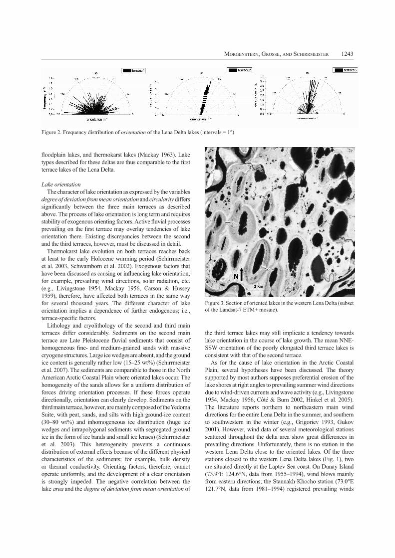
Figure 3. Section of oriented lakes in the western Lena Delta (subset
of the Landsat-7 ETM+ mosaic).
1244 NINTH INTERNATIONAL CONFERENCE ON PERMAFROST
from southern directions with a minor peak from eastern
directions for the whole time span, and from eastern directions
at times of positive air temperatures, respectively. The third
station is located in the central southern delta on Stolb Island
(72.4°E 126.5°N, data from 1955–1991) and shows pronounced
southern wind directions. All three stations may not reflect the
actual wind situation of the second main terrace, as climate on
Stannakh-Khocho and Stolb Island is supposedly influenced by
the mountain ranges flanking the Lena Delta in the south. On the
Island Dunay, which is a few kilometers off from the mainland
of the second terrace, the marine influence has an impact on
weather conditions. It can be suggested though, that, because of
the flat relief of the second terrace, major wind directions in the
inner part of the terrace do not differ much from the situation
at its margins; thus wind data from Dunay Island might be the
most suitable for assessing the situation on the second terrace.
Assuming that the eastern prevailing wind direction measured
over the forty-year time span was consistent throughout the
lake orientation process, the wind hypotheses proposed for
North American oriented lakes might also be applicable for the
oriented lakes of the Lena Delta. However, little is known about
the detailed conditions and factors that might be involved in
lake-orientation processes in the Lena Delta or the stability of
wind regimes over Holocene time scales. Further research is
necessary to prove or reject any particular orientation theory for
this unique Arctic environment.
Conclusions
The three main terraces of the Lena Delta vary largely
in the occurrence of morphometric lake characteristics.
This led to the deduction of one mean lake type for each
terrace. The first main terrace, which represents the modern
active delta, is characterized by small lakes of irregular
shape, like abandoned lakes. Large oriented lakes with
their major axes tending in NNE directions dominate on
the second terrace, which consists of Late Pleistocene to
Early Holocene homogeneous sands. On the third terrace,
which is represented by relics of a Late Pleistocene
accumulation plain with heterogeneous fine-grained and ice-
rich deposits, typical thermokarst lakes with regular, circular
shorelines prevail. Mean morphometric lake characteristics
are consistent with the lithological and cryolithological
conditions and geomorphological processes prevailing on
each terrace. Wind hypotheses proposed for North American
oriented lakes might also explain the orientation of lakes
on the second terrace of the Lena Delta, but the detailed
conditions and mechanisms of the evolution of the oriented
lakes in the Lena Delta remain to be investigated.
Acknowledgments
We thank Thomas Kumke for helpful assistance
with statistical analyses, Mikhail N. Grigoriev, Georg
Schwamborn, and Hartmut Asche for fruitful discussions
and Pier Paul Overduin for grammar and spell check. We
are grateful to Alexander Brenning and another anonymous
reviewer for constructive comments on the manuscript.
References
Are, F. & Reimnitz, E. 2000. An overview of the Lena river
delta setting: geology, tectonics, geomorphology, and
hydrology. Journal of Coastal Research 16(4): 1083-
1093.
Carson, C.E. & Hussey, K.M. 1959. The multiple-working
hypothesis as applied to Alaska’s oriented lakes. Iowa
Academy of Sciences Proceedings 66: 334-349.
Côté, M.M. & Burn, C.R. 2002. The oriented lakes of
Tuktoyaktuk Peninsula, western arctic coast, Canada:
a GIS-based analysis. Permafrost and Periglacial
Processes 13: 61-70.
Fürbringer, W. 1977. About the sedimentology of an arctic
delta (Colville delta, North Alaska). International
Journal of Earth Sciences 66(1): 577-614.
Grigoriev, M.N. 1993. Cryomorphogenesis in the Lena
Delta. Yakutsk: Permafrost Institute Press, 176 pp.
Gukov, A.Yu. 2001. Hydrobiology of the Lena Delta mouth
area. Moscow: Scientific World, 288 pp.
Hinkel, K.M., Frohn, R.C., Nelson, F.E., Eisner, W.R. &
Beck, R.A. 2005. Morphometric and spatial analysis
of thaw lakes and drained thaw lake basins in the
western arctic coastal plain, Alaska. Permafrost and
Periglacial Processes 16: 327-341.
Livingstone, D.A. 1954. On the orientation of lake basins.
American Journal of Science 252: 547-554.
Mackay, J.R. 1956. Notes on oriented lakes of the Liverpool
Bay area, Northwest Territories. Revue Canadienne
de Geographie 10: 169-173.
Mackay, J.R. 1963. The Mackenzie Delta area, N.W.T.
Ottawa: Geographical Branch Memoir 8, Mines and
Technical Surveys, 202 pp.
Schirrmeister, L., Kunitsky, V.V., Grosse, G., Schwamborn,
G., Andreev, A.A., Meyer, H., Kuznetsova, T., Bobrov,
A. & Oezen, D. 2003. Late Quaternary history of the
accumulation plain north of the Chekanovsky Ridge
(Lena Delta, Russia): A multidisciplinary approach.
Polar Geography 27: 277-319.
Schirrmeister, L. (ed.) 2007. Studies of periglacial landscape
dynamics and surface characteristics studies in the
western Lena Delta. Reports on Polar and Marine
Research 550: 83-195.
Schneider, J., Grosse, G. & Wagner, D. Land cover
classification of tundra environments in the Arctic
Lena Delta based on Landsat-7 ETM+ data and
its application for upscaling methane emissions.
Submitted to Remote Sensing of Environment.
Schwamborn, G., Rachold, V. & Grigoriev, M.N. 2002. Late
quaternary sedimentation history of the Lena delta.
Quaternary International 89: 119-134.
Walker, H.J. 1983. Guidebook to permafrost and related
features of the Colville River delta, Alaska. Guidebook
2, Fourth International Conference on Permafrost.
Fairbanks, Alaska: Alaska Division of Geological and
Geophysical Surveys, 34 pp.
Walker, H.J. 1998. Arctic deltas. Journal of Coastal Research
14: 718-738.