Embed Size (px)
Citation preview

GCP
OLC
C
2011 Gulf Coastal Plains & Ozarks Landscape Conservation Cooperative Year of Capacity, Creative Collaboration, Continuity
2011 ANNUAL REPORT
The mission of the Gulf Coastal Plains and Ozarks Landscape Conservation Cooperative is to articulate the shared vision for sustainable natural and cultural resources in the Gulf Coastal Plains and Ozarks geography in the face of a changing climate and other threats; foster a cooperative capacity within the conservation community to meet the challenges of achieving that vision; and facilitate the refinement of that vision through targeted evaluation over time.
The year 2011 was the first full year of existence for the Gulf Coastal Plains & Ozarks Landscape Conservation Cooperative, or GCPO LCC.! The watchwords for the year’s accomplishments were “Capacity, Creative Collaboration, and Continuity.”!
The LCC built!capacity!by adding three new dedicated Conservation Science staff members, and another position still in the process of being filled. However, capacity does not end with the LCC staff.! The expertise of the LCC’s 24 Steering
Committee partners and 7 partnerships - in the form of joint ventures, fish habitat partnerships, and other coalitions - as well as our 600-strong gcpolcc.org membership is truly up to the task of conserving wildlife habitats throughout our 180-million acre geography.
Creative collaboration!really took off in the form of ongoing projects completed and new projects initiated.! The depth and range of projects in which the GCPO LCC plays a role is reflected in the list of 26 projects (see Appendix 1),
spanning a focus from single species to the entire Gulf Coast extending beyond the LCC's boundaries.
Since the Strategic Habitat Conservation framework guides the LCC’s work, projects are categorized according to the five categories of Biological Planning, Conservation Design, Conservation Delivery, Outcome-based Monitoring, and Assumption-driven Research. The LCC Science Coordinator and Research Ecologist play myriad roles in these collaborations, everything from
The Mississippi River, its alluvial valley, Gulf coast, coastal plains and the clear flowing streams of the Ozark karst and Interior Low Plateau define the GCPO geography.

Steering Committee MembersAlabama Department of Conservation and Natural ResourcesGary MoodyAmerican Bird ConservancyDavid PashleyArkansas Game and Fish CommissionDavid GoadAuburn UniversityBarry GrandDucks UnlimitedCurtis HopkinsFlorida Fish and Wildlife Conservation CommissionVacantIllinois Dept. of Natural ResourcesVacantKentucky Department of Fish and Wildlife ResourcesRocky PritchertLouisiana Department of Wildlife and FisheriesKenny RibbeckMississippi Department of Wildlife, Fisheries, and ParksRon Seiss (Vice-chair)Mississippi State UniversityWes BurgerMissouri Department of ConservationGene GardnerNational Bobwhite Conservation InitiativeTom DaileyNational Oceanic and Atmospheric AdministrationDavid BrownOklahoma Department of Wildlife ConservationJohn SkeenTexas Parks and Wildlife DepartmentJeff RaaschThe Conservation FundRay HerndonThe Nature ConservancyScott DavisTN Wildlife Resources AgencySteve PatrickU.S. Fish and Wildlife Service, Region 2Michelle ShaughnessyU.S. Fish and Wildlife Service, Region 3Rich LeopoldUS Fish and Wildlife Service, Region 4Mark Musaus (Chair)US Forest Service, Region 8Mike BalboniUS Forest Service, Region 9Dave WhittekiendUS Geological SurveyAllison Shipp
leading projects to coordinating various initiatives to providing technical expertise at the request of partners.!
The list reflects a delicate balance between short term, “proof-of-LCC-concept” projects with immediate utility and the longer term investments required to address complex threats such as climate change and urbanization.! For example, a completed prioritization model that identifies unoccupied but potentially suitable habitats for the federally-threatened Louisiana Pearlshell Mussel will facilitate search and restoration efforts, and it could be used to guide outreach to land conservancies working in key areas.! On the other hand, development of a consistent land cover database for the entire LCC and a Conservation Planning Atlas to serve the data is a multi-year project that appears to be uniformly welcomed by the conservation community. !It will provide value to many analyses for years to come.
In 2011 the GCPO LCC worked on ensuring the!continuity!of its efforts, in full awareness that even within our large geography, the rivers, migratory species, habitats, and jurisdictions do not stop at our borders.! We focused on coordinating with neighboring LCCs and working as part of a larger coalition of conservation organizations whose area of influence extends throughout the Southeast United States.!
An example of this is the GCPO LCC Steering Committee, under the guidance of Greg Wathen, collaborating with the US Fish & Wildlife Service Coordinator and the Southeastern Association of Fish & Wildlife Agencies to initiate a long range Conservation Adaptation Strategy to sustain fish and wildlife populations over the next 50 years.! Our Gulf Coast Landscape Conservation Liaison works for the GCPO and three other coastal LCCs to ensure continuity of effort for the entire Gulf coast and Gulf of Mexico.! Our Communications Strategy focuses on setting up the means for keeping scientists, practitioners, and planners - both within and outside the LCC - linked, informed and engaged.!
Gulf Coast gulls and skimmers

Oct 23, 2011 Nashville, TNValue-added Roles of the GCPO LCC in Building a Future Conservation LandscapeFocusing on the unique abilities of LCCs, the Steering Committee discussed how the LCC can add to, complement and tie together existing regional conservation efforts by:!Approving completion of the Communications Strategy.!Approving formation of a Science Management Team, as well as further work to develop examples of vulnerabilty assessments for their review in Spring 2012.
LCC staff also briefed the SC concerning ongoing landscape and climate change research:!Mike Osland presented his research on the use of down-scaled climate models to project future impacts on Gulf Coast mangrove forests.!Greg Wathen presented information on the initiative led by the Southeastern Association of Fish & Wildlife Agencies (SEAFWA) to develop a Southeast Conservation Adaptation Strategy. The SC approved moving forward with development of this strategy, in which LCCs will take a lead role.!Laurie Rounds, the LCC’s latest hire, as a shared position among the four Gulf Coast LCCs and NOAA, introduced herself and gave an overview of NOAA coastal programs.
Fall 2011 digital notebook and presentations to Interim Steering Committee
June 7-9, 2011 Eureka Springs, AR Charting the Course of the GCPO LCC The GCPO LCC Steering Committee (SC) met for three days in the Ozarks region of northwestern Arkansas. Following the meeting theme of "Charting the Course of the GCPO LCC," the Steering Committee took the following actions to define borders by:!approving a geographic construct for research and analysis - bird conservation regions for terrestrial, and HUC2s for aquatic;!proposing to share conservation planning responsibilities in the Interior Low Plateau with the Appalachian LCC, which would have GCPO take the lead on terrestrial planning and the ALCC take the lead on aquatics;!deferring action on the Apalachicola-Chattahoochee-Flint River Basin (ACF) of AL and GA until further consultation can occur.
To ensure conservation that lasts, the SC approved investments in tools for long-term monitoring and assessment of climate change effects:
!development of species and ecosystem vulnerability assessments;!continued investment to develop a consistent GCPO LCC Land Cover Database as well as the hiring of a GIS analyst at Mississippi State University;!creation of a Conservation Planning Atlas to deploy and serve information from the land cover database.
Operationally, the LCC is now secure in its identity and its procedures:!the SC agreed to re-establish the LMVJV Management Board as a separate entity.!The SC approved Operational Guidelines and selected Mark Musaus (USFWS) as Chair, Ron Seiss (MDFWP) as Vice-chair.
The SC approved investment of resources to expand staffing capacity by:!Hiring an Advanced Applications Specialist position at the National Wetlands Research Center.!Hiring a Communications Specialist and developing a Communications Strategy.Spring 2011 presentations to LCC Steering Committee and LMVJV
STEERING COMMITTEE MEETINGS
“Bonding” while canoeing the King River, AR
Engaging Partners and PartnershipsAs has been stated many times by the GCPO LCC and others, the LCC does not exist in the absence of its Steering Committee partner organizations and the numerous partnerships, such as joint ventures, that have long been active in the Gulf Coastal Plains and Ozarks region. Collaboration makes the LCC. Highlights of 2011 collaboration include:
The GCPO LCC Advisory Council held its first meeting in September 2011 in Starkville, MS. Current members include the Southeast Aquatic Resources Partnership, Lower Mississippi River Conservation Committee, Lower Mississippi Valley Joint Venture, Gulf Coast JV, East Gulf Coastal Plains JV, Central Hardwoods JV, and Black Bear Conservation Coalition.
LCC staff worked with the National Oceanic and Atmospheric Administration (NOAA) on behalf of 4 LCCs with Gulf of Mexico conservation planning responsibilities and established a NOAA-LCC Gulf Coast Landscape Conservation Liaison position (Laurie Rounds). The position is providing conservation planning services and engagement with the Gulf of Mexico conservation community.
LCC staff and staff of the USGS Tennessee Water Science Center explored the potential for the USGS National Water Quality Assessment Program (NAWQA) to develop conservation strategies that benefit fish and wildlife populations in the Lower Mississippi Valley, as well as improvements to the Gulf of Mexico Hypoxia Zone.
Greg Wathen worked along with other LCCs with southeastern geographical responsibilities and with Science Applications staff of USFWS to engage Ed Carter, Director of TWRA, and other leadership within the Southeastern Association of Fish & Wildlife Agencies (SEAFWA), to initiate the development of a Southeast Conservation Adaptation Strategy (SECAS), a long range conservation planning vision to sustain fish and wildlife populations over the next 50 years.
The Steering Committee established the GCPO LCC Advisory Council in June 2011 as a way to engage the various conservation partnerships with planning responsibilities within the GCPO geography (joint ventures, fish habitat partnerships, etc.), and to facilitate coordination and integration of their collective planning activities. The charge and purpose of the Advisory Council is laid out in the Steering Committee’s Operational Guidelines:
“The Council will provide a forum for: 1) formal collaboration on projects of mutual interest; 2) sharing resources and assets to meet mutual goals and objectives; and 3) making recommen-dations on priority projects, strategies, and initiatives for the collective GCPO LCC conservation community.” The initial meeting of the GCPO LCC Advisory Council was held at MSU’s Geosystems Research Institute in September 2011. [Meeting Notes]
Wappanocca National Wildlife Refuge bottomlands
Partnership Advisory Council
MembersBlack Bear Conservation CoalitionMurray LloydCentral Hardwoods Joint VentureJane FitzgeraldEast Gulf Coastal Plain Joint VentureCatherine RideoutGulf Coast Joint VentureBarry WilsonLower Mississippi Valley Joint VentureKeith McKnightLower Mississippi River Conservation CommitteeRon NassarSoutheast Aquatic Resources PartnershipScott Robinson

Conservation Science StaffingCoordinator – Greg WathenTN Wildlife Resources Agency, Nashville, TN
Science Coordinator – John Tirpak USFWS, National Wetlands Research Center, Lafayette, LA
Research Ecologist – Mike Osland USGS, National Wetlands Research Center, Lafayette, LA
Communications Specialist – Karen “Gregg” ElliottK Gregg Consulting, Memphis, TN
Gulf Coast Landscape Conservation Liaison – Laurie RoundsNOAA, Nashville, TN
GIS Analyst – expected February 2012Geosystems Research Institute, Mississippi State University, Starkville, MS
Through the GCPO LCC’s web site, gcpolcc.org, we have engaged partners to develop working groups devoted to various topics and issues of interest within the GCPO geography. Approximately 374 gcpolcc.org members are involved in at least one of 16 established working groups (screenshot above). As of early February 2012, the website has a total of 586 members, with more joining every day.
Managing the GCPO LCCThe Conservation Science Staff of the GCPO LCC are representative of the diversity of its Steering Committee. The Coordinator, Greg Wathen, is an employee of Tennessee Wildlife Resources Agency in Nashville, TN. TWRA provides office space and administrative support for the Coordinator’s position. The National Wetland Research Center, a USGS facility located in Lafayette, LA, provides office space and administrative support for the GCPO LCC Science Coordinator, John Tirpak, and a USGS Research Ecologist, Mike Osland. Additional office and administrative support has been provided by the USFWS and staff in the Lower Mississippi Valley Joint Venture office, located in Vicksburg, MS. Laurie Rounds, Gulf Coast LCC Liaison, works for the National Oceanic and Atmospheric Administration (NOAA) through a contractual arrangement, and is a shared
position between NOAA, and the 4 LCCs with Gulf Coast and Gulf of Mexico responsibilities (Gulf Coastal Plains & Ozarks, Gulf Coast Prairie, South Atlantic, and Florida Peninsular). To round out our representation in the world of private enterprise, our Communications Specialist is a private consultant hired on contract.
The GCPO LCC is also working with the Geosystems Research Institute (GRI), and the High Performance Computing Collaboratory (HPC2) at Mississippi State University, Starkville, MS. Through an agreement with the Gulf Coast Cooperative Ecosystem Study Unit, of which MSU and DOI are members, the Geosystems Research Institute is providing geospatial and analytical services, as well as administrative and clerical support to administer contracts and subcontracts, proposals, payment procedures, etc. Mississippi State University is also hosting an Assistant Research Professor position in geospatial analysis and remote sensing, to provide the GCPO LCC with GIS support. MSU has offered to provide office space and associated utilities and support for four to five permanent GCPO LCC Conservation Science staff, as needed.
The Groups page of gcpolcc.org

Biological PlanningDynamic Landcover Model: The GCPO LCC and USGS Arkansas Water Science Center co-hosted the inaugural meeting of the Geomatics Working Group in Little Rock, AR, where they articulated a vision and process to produce a dynamic and biannually updated seamless land cover for the GCPO LCC. Work began in April 2011.
Mississippi State University’s Chuck O’Hara investigated the characteristics, gaps in coverage, limitations, and opportunities associated with various land cover approaches. He developed a white paper that clarifies the relationship of the National Land Cover Dataset (NLCD), the Southeast and other regional GAP Projects, Landfire, and the National Agricultural Statistics Service (NASS) to the parent Multi-Resolution Land Characteristics Consortium (MLRCC). The MRLCC has provided the base satellite imagery for each of these various land classification efforts.
MSU opened a dialogue with individuals at the USGS Earth Resources Observation and Science (EROS) Center, who indicated that they would be amenable to working with the LCC to develop and covalidate a dynamic, seamless and extensible GCPO-specific landcover data layer that integrates multiple data sources – both those that are derived from the MRLCC and ancillary datasets (e.g. the Forest Inventory and Analysis).
Winter Waterfowl Vulnerability Assessment:A Weather Severity Index is being developed to predict the temporal and spatial distribution of waterfowl wintering in the Mississippi Flyway. This project will apply the Weather Severity Index to downscaled climate projections to predict the timing and location of winter waterfowl migration in the Atlantic and Mississippi Flyways under alternative climate futures. The LCC is funding this project and connecting it to standardized waterfowl monitoring.
Priority ProjectsTo meet its mission, the GCPO LCC has adopted the Strategic Habitat Conservation (SHC) framework as a business approach for its various activities. Through SHC, the LCC accomplishes activities in an integrated and strategic fashion focusing on Biological Planning, Conservation Design, Conservation Delivery, Outcome-based Monitoring, and Assumption-driven Research. The conservation planning activities of the GCPO LCC are implemented under the guidance and principles of the SHC framework in order to ensure a consistent and logical approach toward defining landscapes capable of sustaining GCPO fish and wildlife populations at desired levels well into the future.
The GCPO LCC is also developing a Communications Strategy, which will be integrated across the SHC framework. For each of the 5 basic components of SHC, the Communications Specialist and Working Group are developing specific communications objectives and strategies, with the goal of improving and enhancing the effectiveness of science and outreach activities within the framework. Overall, by strengthening and enhancing the LCC’s collaboration and dissemination of science-based project needs and results, the Communication Strategy will boost the LCC’s capabilities in achieving landscape sustainability within the GCPO LCC geography.
Appendix 1 provides a comprehensive listing and description of the activities and projects that the GCPO LCC engaged in during 2011. Projects described here are illustrative
Greenwing Teal

Louisiana Pearlshell Mussel Habitat Assessment: The LCC, FWS, USFS and TNC are developing a prioritization model for identifying potentially suitable but currently unoccupied habitats to target search and restoration efforts for the federally-threatened Louisiana Pearlshell Mussel. A poster outlining this project is available at.
LCC staff recruited a working group and developed a model. The LCC may want to conduct outreach to local conservancies working with landowners in priority restoration areas.
Alligator Gar Priority Tool: Researchers with the Alligator Gar Technical Committee are partnering with the GCPO to create an aquatic species habitat model. Three sets of data (LiDAR, Landsat satellite imagery, and instream water quality) will be combined, using the modeling and GIS expertise of the GCPO LCC, to identify areas within the Mississippi Alluvial Valley potentially suitable for alligator gar, particularly the best areas for restoring spawning habitat or for gar reintroduction. The St. Catherine Creek NWR, an active gar spawning area, is the standard for defining high quality habitat. Details on this project are available from the Alligator Gar Working Group.
Black Bear Vulnerability Assessment: A vulnerability assessment is planned for the two subspecies of black bear within the GCPO LCC region. A scoping document is available. The Black Bear Conservation Coalition (BBCC) will pull together the partners that can provide specific expertise on bear ecology and management; the LCC will conduct the vulnerability assessment and facilitate the transfer of information from and to the black bear conservation community.
Ecological Assessment of Mississippi River Dike Notching: Dike notching is used to recreate secondary channels that serve as important habitats for many priority species in the Mississippi River. Anecdotal evidence suggests strong response by pallid sturgeon, fat pocketbook mussels, and least terns, but this has never been quantified. This project will use bathymetry data to assess physical changes in channel morphology at local scales, which will then be tied to ecological responses of each of the target species.
Conservation DesignToward a Treasured Landscape: Integration of Black Bear and Forest Bird habitat Decision Support Tools in the Lower Mississippi Valley. Phase I integrated a reforestation decision support model for priority forest breeding birds and a restoration decision support tool for the federally Threatened Louisiana Black Bear. Phase II, ongoing, will develop and integrate an aquatic resource decision support tool with the terrestrial decision support tool. Phase III will incorporate downscaled climate models into restoration priorities as base information for a fish and wildlife adaptation strategy.
Integrated Coastal Assessment (Southeast Regional Assessment Project or SERAP): This project assessed the impacts of projected sea level rise on coastal areas of the GCPO LCC. The project is complete, and products are available at:http://serap.er.usgs.gov/docs/SerapOFR2010_1213.pdf and http://gom.usgs.gov/slr/index.html.
Black Bear - USFWS image
Alligator Gar, USFWS image

Mangrove migration modeling: This pilot project uses observed and!projected climate data to evaluate the potential impacts of climate change!on coastal mangrove forest ecosystems in the southeastern United States.!While the project is ongoing, the preliminary results are striking in!terms of the potential for mangrove forest range expansion and coastal!marsh displacement in the region.
Central Hardwood Climate Change Modeling: The University of Missouri and USDA Forest Service Northern Research Station are working with the Central Hardwoods Joint Venture to link a forest process model, wildlife species habitat models, and climate model.
The objective of this project is to predict future landscape composition and structure under a range of climate scenarios for the Central Hardwood Bird Conservation Region over the next 100 years.
We will use the forest process model LINKAGES to estimate tree establishment and early growth
across the region under three climate scenarios. These predictions will be input to the dynamic landscape model LANDIS to simulate ecosystem and landscape processes such as disturbance, succession, and land management. We will then model three climate scenarios representing the most conservative to the most extreme climate change predictions.
Comparing future landscape projections to current species habitat models will inform habitat management. Work begins spring of 2012.
Central Hardwoods land use map shows urban hotspots in red.
Outcome-based MonitoringAerial Survey Protocol for Waterfowl: Mississippi State University has contracted with Dr. Sarah Lehnen to design and validate an aerial survey protocol for waterfowl. In 2010, Dr. Lehnen developed a preliminary graphical user interface to facilitate bird identification and counts, which was implemented by Arkansas and Mississippi during the 2010 - 2011 winter season. This ongoing project will follow up by refining previously developed protocols as well as implementing new procedures. Objectives are to increase the precision of counts, develop a visibility correction factor for waterfowl detection during aerial surveys, and develop a GIS method of rapidly displaying waterfowl distribution and abundance over time and space.
Training in Acoustical Bat Surveys: Mississippi has developed a contract with Janet Tyburec to design and instruct a workshop for USFWS Region 4 to train their staff in the use and deployment of Zero-crossing (AnaBat) acoustic bat detectors, data collection through identification of echolocation calls, and interpretation of data using AnaLook analysis software. The goal is to use this equipment as a core tool for the non-contact, acoustic inventory and monitoring of bats - especially urgent in response to the ongoing spread of White-Nose Syndrome. This workshop will provide up to 15 students with 2 days and nights of classroom instruction, hands-on lab work, and an outdoor field study component.

2009lorem ipsum dolor met set quam nunc parum
Beyo
nd LC
C
Bord
ers
GULF COAST RESTORATIONCONSERVATION PLANNING ATLAS
COMMUNICATIONSCENTRAL HARDWOODS MODELING
SE CONSERVATION ADAPTATION
“The LCC needs to facilitate communication and consistency of efforts - inventory, monitoring, research, data - across all LCCs to meet the needs of national or larger regional initiatives, such as longleaf pine or quail conservation.” - Tom Dailey, National Bobwhite Conservation Initiative
Gulf Coast Landscape Conservation LiaisonThe NOAA Office of Ocean and Coastal Resource Management (OCRM) and the U.S. Fish and Wildlife Service have established a Gulf Coast liaison position to advance shared goals of cooperative conservation and climate change adaptation in the Gulf Coast region. The liaison will coordinate between the South Atlantic, Peninsular Florida, Gulf Coastal Plains and Ozarks, and Gulf Coast Prairie LCCs to enhance communication with Gulf Coast stakeholders; identify and coordinate resources for regional priorities; and support integration of climate products and services for Gulf Coast application.! The position will also liaise with Gulf Coast resource managers to identify best
practices, connect efforts, identify gaps, and avoid duplication of effort.
The liaison, Laurie Rounds, has been working with partners to identify opportunities to engage with Gulf Coast regional conservation initiatives, such as Coastal and Marine Spatial Planning. Partners have begun a vulnerability assessment effort that will synthesize existing data, information from scientific studies, models and other analysis tools, and the scientific knowledge of a range of experts about the vulnerability of coastal ecosystems to changing conditions.
President Obama established the Gulf Coast Ecosystem Restoration Task Force to develop an ecosystem restoration strategy in cooperation
with the Gulf States that would address the long-term impacts of the Deepwater Horizon oil spill, Hurricane Katrina, and other recent disasters. In addition, the Gulf’s estuaries and coastal systems are impacted by a variety of stressors, including pollution, coastal development, energy development, erosion, alteration of natural hydrology, changes in freshwater inflow, sea level rise, and climate change. The largest hypoxic zone in the U.S., averaging over 7,700 square miles, occurs annually off the Northern Gulf Coast at a crucial time of the year for commercial and recreational fisheries.
Charged with working toward a sustainable Gulf Coast, the Task Force released the Gulf Coast Restoration Strategy in December
The Southeast incorporates parts or all of 8 LCCs, and 4 LCCs border the Gulf of Mexico

Assessing the Impact of Climate Change on Central Hardwoods The CHJV is working closely with Frank Thompson of the US Forest Service Northern Research Station, Dan Dey of the Columbia Forest Experiment Station, and a diverse group of partners including nonprofits, national forests and the GCPO LCC to assess the impact of climate change on forests. As described in the discussion of the Central Hardwood Climate Change Modeling, the goal is to develop a set of tools that will allow people to visualize not only broadscale climate change effects, but effects at the tree stand level to support “climate smart” conservation and forest management.
This project will model forest species composition, landscape pattern, and wildlife habitat in regions of Missouri, Illinois and Indiana. It will provide an idea of how certain management regimes and expected changes in climate under different scenarios will affect forest conservation one to two hundred years into the future.
2011, which sets out regional ecosystem restoration goals and a path forward in cooperation with the Natural Resource Damage Assessment resulting from the oil spill. The Gulf LCCs were identified in the strategy as an important initiative to provide scientific and technical support for landscape–scale adaptive conservation by supporting conservation planning, providing decision support tools, prioritizing and coordinating research, and designing inventory and monitoring programs. Therefore, the LCCs have an important role in working with many conservation partners to support ecosystem restoration of the Gulf Coast.
Conservation Planning Atlas for Integration of Existing Conservation PrioritiesThe GCPO Science Team, along with the SALCC and GCPLCC have each identified the need for a Conservation Planning Atlas (CPA) to help provide geospatial data to researchers, managers, and planners in a consistent format with documented metadata. Currently, as mentioned in the discussion of the Dynamic Land Cover Model, much of the data is of unknown origin, in disparate projections and measures, and of questionable reliability. Primary needs are collecting and manipulating datasets from individual partners to derive consistent data (e.g., current rather than acquisition boundaries for all Wildlife Management Areas) across the
GCPO geography - and potentially the entire Southeast - and then distributing the manipulated data.
MSU’s Chuck O’Hara provided an overview of options for establishing a dynamic, scalable, extensible geospatial portal that would locate, access, and expose to end-users and partners standardized, current, and consistent geospatial data layers and services (i.e., clip, zip, and ship). O’Hara suggested an ERDAS Apollo server is well designed for achieving exactly that. O’Hara developed a white paper and a tiered proposal describing the development of the planning atlas for just the GCPO LCC and for the entire Southeast. A proof-of-concept could be developed using existing data, and the Geomatics Working Group is currently considering the proposal.
Communications Strategy The GCPO LCC Steering Committee approved the hiring of a Communications Specialist, who recruited a Communications Working Group to assist in developing an LCC Communications Strategy. The Communications Strategy seeks to build a network of communicators both within and outside the LCC. It is embedded within the Strategic Habitat Conservation framework, and specific objectives and strategies are being defined for each of the five basic SHC elements.
Bobcat Gopher Tortoise Mussel Gar species

2011Gulf Coastal Plains & Ozarks Landscape Conservation Cooperative
The foundation!for a SECAS will be conservation planning efforts already in place, such as the State Wildlife Action Plans, bird conservation plans (NAWMP, PIF, NBCI, etc.), National Fish Habitat Action Plan, and TNC Ecoregional Plans. The LCCs will provide dedicated capacity and play a lead role in integrating these existing planning efforts while applying new and emerging geospatial technologies to assess projected changes on the landscape.
The South Atlantic, Peninsular Florida, Gulf Coastal Plains and Ozarks LCCs, as well as Appalachian LCC and Gulf Coast Prairie LCC are collaborating in this effort.! The USGS Southeast Climate Science Center in North Carolina will!have!primary responsibility for developing the climate science capacities needed to better forecast potential impacts from anticipated climate change.
Strategies will be modeled on resilience strategies recommended by the U.S. Climate Change Science Program in its 2008 report, Adaptation Options for
Climate Sensitive Ecosystems and Resources (Julius et al. 2008).
The Southeast Conservation Adaptation StrategyThe Southeastern Association of Fish!&!Wildlife!Agencies!(SEAFWA) approved the development of a comprehensive Southeast Conservation Adaptation Strategy, or SECAS, at their October 2011 meeting.! The goal of the Conservation Adaptation Strategy is to bring the conservation community together to develop the vision and strategies needed to sustain fish and wildlife populations at desired levels in the face!of major stressors, such as human population growth (which in the South exceeds the national growth rate) and attendant issues of forest loss and water stress.!
!For more information please contact Greg Wathen at [email protected] or John Tirpak at [email protected]!Please consider joining the gcpolcc.org and its work groups to stay abreast of and participate in GCPO conservation planning. !To submit information to the website or for the newsletter, the GCPO Monitor, please contact Gregg Elliott at [email protected].
Increased temperatures may increase drought and the need for prescribed fire for hazard reduction. Southern pine forests are adapted to fire.

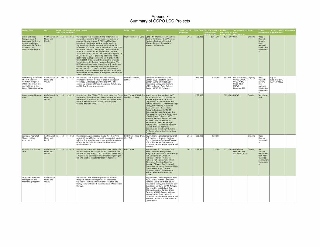
Appendix Summary of GCPO LCC Projects
Project Title LCC Proposed Start Date
Proposed End Date
Description Project Lead Partners Fiscal Year of Allocation
Total Cost FWS LCC Dollars (appropriated 1410 & 1420)
In-kind, matching, or other funds
Source(s) of In kind, Matching, or other funds
Status Type of Deliverable
Link to Product or Deliverable
Comments
Expanding the Integrated Coastal Assessment to the Panhandle of Florida (Links to SALCC)
Gulf Coastal Plains and Ozarks
10/1/09 9/30/12 This project will use a Bayesian statistical framework for predicting coastal erosion and inundation under a range of sea level rise scenarios. The Bayesian frame work will also develop visualization products that will help natural resource managers anticipate sea level rise and adapt to the projected changes. Lastly, the frameworks will asses the potential impacts of sea level rise on coastal ecosystems and related wildlife resources.
Nathaniel Plant, Glenn R. Guntenspergen, K. Van Wilson, Scott Wilson, Cindy Thatcher, Alexa McKerrow, and Adam Terando
LMVJV; SALCC; USGS-National Wetlands Research Center; USGS-SERAP; USGS SE Climate Science Center; and other GCPO partners as needed
2010 $40,000 $40,000 $267,000 USGS - NCCWSC
Completed Map; Dataset; Report; Peer-reviewed Publication; Presentation; Web-based Tool
http://serap.er.usgs.gov/ http://gom.usgs.gov/slr/index.html
Toward a Treasure Landscape Decision Support Tool to Safeguard Priority Fish and Wildlife Populations in the Mississippi Alluvial Valley-Phase I: Targeting Walton Family Foundation Grant
Gulf Coastal Plains and Ozarks
1/1/10 4/1/10 Phase I integrates a reforestation decision support model for priority forest breeding birds and a restoration decision support tool for the federally Threatened Louisiana Black Bear. Phase II will develop and integrate aquatic resource decision support tool with the terrestrial decision support tool. Phase III will incorporate downscaled climate models into restoration priorities as base information for a fish and wildlife adaptation strategy.
Bill Uihlein - LMVJV Black Bear; Conservation Coalition; DU; LMVJV; TNC; USFWS; Walton Family Foundation; and other GCPO partners as needed
2010 $5,000 $5,000 Completed Map; Dataset
Resulted in $2,250,000 grant funds from Walton Family Foundation, targeted to AR, MS, and LA MAV priority areas.
Gulf Coastal Plains and Ozarks Classification of Aquatic Resources (e.g., Rivers, Streams, Lakes, etc) Reflecting Standardized Categories for Biological and Physical Characteristics-Phase I
Gulf Coastal Plains and Ozarks
5/1/10 12/1/13 This project will initiate the development of a seamless aquatic resource dataset for the entire GCPO LCC geography. Existing partnerships (e.g., Southeast Aquatic Resource Partnership) as well as existing datasets will be utilized to define a common classification system.
Larry Handley - USGS-NWRC
SARP; USGS - Mid-continent Geographic Science Center; USFWS; and other GCPO partners as needed
2010 $100,000 $25,000 USGS (in-kind) Not Started Map; Dataset; Report; Peer-reviewed Publication; Presentation; Web-based Tool
Oil Spill efforts in support of NRDA have stalled this project
CESU Agreement w/ MS State University
Gulf Coastal Plains and Ozarks
9/1/10 8/31/15 This Cooperative Ecosystem Studies Unit (CESU) agreement allows the USFWS and MS State University to facilitate the strategic mission of the GCPO LCC, to cooperatively and collaboratively conduct biological planning, conservation design, outcome-based monitoring and assumption-driven research, in support of sustaining fish, wildlife, and cultural resources. MS State Univ. serves as an umbrella institution to coordinate and fund efforts with other partners in support of the GCPO LCC's mission.
Wes Burger, MSU 2010 Ongoing Study Plan, Annual Report, Final Report.
Total 2010 funds - $741,949.60.
CESU Agreement w/ MS State University
Gulf Coastal Plains and Ozarks
9/1/10 8/31/15 This Cooperative Ecosystem Studies Unit (CESU) agreement allows the USFWS and MS State University to facilitate the strategic mission of the GCPO LCC, to cooperatively and collaboratively conduct biological planning, conservation design, outcome-based monitoring and assumption-driven research, in support of sustaining fish, wildlife, and cultural resources. MS State Univ. serves as an umbrella institution to coordinate and fund efforts with other partners in support of the GCPO LCC's mission.
Wes Burger, MSU 2011 Ongoing Study Plan, Annual Report, Final Report.
Total 2011 funds - $720,000.00.
Coordinator Support Services for the GCPO LCC
Gulf Coastal Plains and Ozarks
1/1/11 12/31/15 This project provides Coordinator support to the Gulf Coastal Plains & Ozarks LCC partnership. Through a cooperative agreement between the USFWS and TN Wildlife Resources Agency has agreed to provide office and logistical support for the Coordinator's position for the GCPO LCC.
USFWS - Bill Uihlein; TWRA - Greg Wathen
TN Wildlife Resources Agency 2011 $301,300 $271,300 $30,000 TWRA (in-kind) Ongoing Annual, Final Report.
Common Ground: Expanding and Updating Land Cover Classifications for the Gulf Coastal Plains and Ozarks Landscape Conservation Cooperative(Nature Serve's Ecological Systems)
Gulf Coastal Plains and Ozarks
5/1/11 9/30/13 This project will produce a seamless land cover dataset for the entire GCPO LCC geography that is based on the classification protocol developed by SE-GAP. The new land cover map would be created using the most current imagery available (2009-2010). Concurrent with the geographic expansion of the SE-GAP land cover mapping will be a change detection effort that will provide updated land cover for portions of the GCPO geography previously mapped based on 2001 imagery.
Chuck O'Hara Mississippi Statue University; Geosystems Research Institute; LMVJV; NC State, MoRAP, TPWD; USFS; USFWS; USGS; MRLC; NOAA; USDA NASS; and other GCPO partners as needed
2011 $334,310 $284,310 $50,000 MSU-GRI hardware and software costs associated with high performance computing capacity
Ongoing Map; Dataset; Report; Peer-reviewed Publication; Presentation
Communications Specialist Services
Gulf Coastal Plains and Ozarks
8/1/11 12/31/11 This project provides Communications services for the GCPO LCC, specifically producing communications products, including a Communications strategy, newsletter, and GCPO LCC web site maintenance.
Greg Wathen K. Gregg Consulting 2011 $30,000 $30,000 Ongoing
Developing long-term urbanization scenarios for the Appalachian and GCPO LCCs as part of the Southeast Regional Assessment Project
Gulf Coastal Plains and Ozarks
7/1/11 1/31/13 Description: As part of SERAP project, SLEUTH models were developed for much of the Southeast. This project will expand this dataset to cover the entire GCPO geography. b. LCC Role: The LCC identified the need for complete coverage across the entire geography and worked with the SE Climate Science Center to address this gap. LCC staff will be asked to provide input for various scenarios.
Jaime Collazo, USGS Appalachian LCC; South Atlantic LCC; Southeast Climate Science Center; North Carolina State University; USGS North Carolina Cooperative Fish and Wildlife Research Unit
2011 $73,742 $2,500 $71,242 USGS - SECSC Ongoing Map; Dataset; Report; Peer-reviewed Publication; Presentation
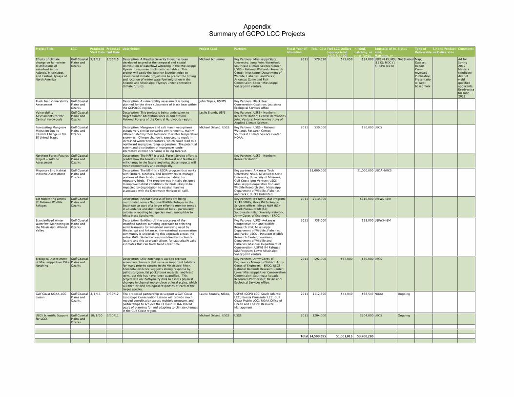
Appendix Summary of GCPO LCC Projects
Project Title LCC Proposed Start Date
Proposed End Date
Description Project Lead Partners Fiscal Year of Allocation
Total Cost FWS LCC Dollars (appropriated 1410 & 1420)
In-kind, matching, or other funds
Source(s) of In kind, Matching, or other funds
Status Type of Deliverable
Link to Product or Deliverable
Comments
Linking Climate, Ecosystem, and Landscape Models to Assess Landscape Change in the Central Hardwood Bird Conservation Region
Gulf Coastal Plains and Ozarks
10/1/11 9/30/15 Description: This project is being undertaken in conjunction with the USFS’s Northern Institute of Applied Climate Science (NIACS) and Northern Experiment Station to use the Landis model to simulate future landscapes that incorporate the influences of climate change, urbanization, and other landscape stressors. This project will also conduct initial assessments of the implications of these alternative landscapes on fish and wildlife species. b. LCC Role: The LCC is providing additional funds ($150 K) to leveraging existing funds provided by NIACS ($375 K) to expand this modeling effort to include the entire Central Hardwoods region. The LCC Science Coordinator is working with the Central Hardwoods Joint Venture Science Coordinator to ensure this effort is useful to their conservation planning, while also ensuring it provides a valuable input for the development of a regional Conservation Adaptation Strategy.
Frank Thompson, USFS, USFS - Northern Research Station; Central Hardwoods Joint Venture; Northern Institute of Applied Climate Science; University of Missouri - Columbia
2011 $556,206 $181,206 $375,000 USFS Ongoing Map; Dataset; Report; Peer-reviewed Publication; Presentation
Forecasting the Effects of Land-Use and Climate Change on Wildlife Communities and Habitats in the Lower Mississippi Valley
Gulf Coastal Plains and Ozarks
10/1/09 9/30/13 Description: This project is focused on using downscaled climate models to predict changes in hydrology and landcover within the MAV. The secondary impacts of these changes on fish, herps, and birds will also be assessed.
Stephen Faulkner, USFWS
– National Wetlands Research Center; USGS – Leetown Science Center; Ducks Unlimited; Lower Mississippi Valley Joint Venture; USGS – Arkansas Water Science Center; USFWS R4 Fisheries.
$949,491 $10,000 $939,491 USGS-NCCWSC; USFWS-LMVJV, USGS-ARMI, USGS-WRD; USFWS-Fisheries; DU
Ongoing Map; Dataset; Report; Peer-reviewed Publication; Presentation
http://pubs.usgs.gov/fs/2010/3112/
Conservation Planning Atlas
Gulf Coastal Plains and Ozarks
10/1/10 9/30/13 Description: The GCPOLCC Geomatics Working Group is pursuing development of an on-line platform that serves data in a consistent manner and allows end-users to easily discover, access, and integrate existing data and tools.
John Tirpak, USFWS; Rua Mordecai, USFWS
Key Partners: South Atlantic LCC; Peninsular Florida LCC; USFWS R4 Science Applications; Alabama Department of Conservation and Natural Resources; Lower Mississippi Valley Joint Venture; Mississippi State University – Geosystems Research Institute; USFWS R4 Ecological Services; American Bird Conservancy; Louisiana Department of Wildlife and Fisheries; USGS – National Wetlands Research Center; Southeast Aquatic Resources Partnership; USFWS R4 Refuges; NatureServe; Tall Timbers Research Station; National Bobwhite Conservation Initiative; U.S. Army – Ft. Bragg; Information International Associates.
$275,000 $275,000 USFWS Ongoing Web-based tool
Louisiana Pearlshell Mussel Habitat Assessment
Gulf Coastal Plains and Ozarks
12/1/10 9/30/12 Description: A prioritization model for identifying potentially suitable but currently unoccupied habitats is being developed to target search and restoration efforts for the federally-threatened Louisiana Pearlshell Mussel.
Bill Uihlein - FWS; Bruce Alt - TNC
Key Partners: Natchitoches National Fish Hatchery; Kisatchie National Forest; Louisiana Ecological Services office; The Nature Conservancy; Louisiana Department of Wildlife and Fisheries.
2011 $20,000 $20,000 Ongoing Map; Dataset; Presentation
Alligator Gar Priority Tool
Gulf Coastal Plains and Ozarks
12/1/10 9/30/13 Description: A model is being developed to identify areas within the Mississippi Alluvial Valley that are suitable for alligator gar. St. Catherine’s Creek NWR – a high quality active spawning area for alligator gar – is being used as the standard for comparison.
John Tirpak Key partners: St. Catherine Creek NWR; USFWS R4 Refuges I&M Program; R4 Fisheries – Baton Rouge Fish Coordination Office; R4 Fisheries – Private John Allen National Fish Hatchery; Southern Division of American Fisheries Society – Alligator Gar Technical Committee; Arkansas Game and Fish Commission; Army Corps of Engineers – ERDC; Southeastern Aquatic Resources Partnership (SARP)
2011 $138,000 $5,000 $133,000 USFWS-I&M ($45,582.67); SARP ($60,000)
Ongoing Map; Dataset; Web-based tool; Peer-reviewed publication; Presentation
Integrated Waterbird Management and Monitoring Program
Gulf Coastal Plains and Ozarks
Description: The IWMM Program is an effort to integrate wetland management for shorebirds, waterbirds, and waterfowl at local, regional, and Flyway scale within both the Atlantic and Mississippi Flyways.
Key partners: USFWS Migratory Birds R3, 4, and 5; Atlantic Coast Joint Venture; Ducks Unlimited; Lower Mississippi Valley Joint Venture, Gulf Coast Joint Venture; USFWS Refuges R3, 4, and 5; Lincoln Park Zoo; Chicago Botanical Garden; USGS Patuxent Wildlife Research Center; North Carolina State University; Louisiana Department of Wildlife and Fisheries; Arkansas Game and Fish Commission.
Appendix Summary of GCPO LCC Projects
Project Title LCC Proposed Start Date
Proposed End Date
Description Project Lead Partners Fiscal Year of Allocation
Total Cost FWS LCC Dollars (appropriated 1410 & 1420)
In-kind, matching, or other funds
Source(s) of In kind, Matching, or other funds
Status Type of Deliverable
Link to Product or Deliverable
Comments
Effects of climate change on fall-winter distributions of waterfowl in the Atlantic, Mississippi, and Central Flyways of North America
Gulf Coastal Plains and Ozarks
9/1/12 5/30/15 Description: A Weather Severity Index has been developed to predict the temporal and spatial distribution of waterfowl wintering in the Mississippi Flyway in response to climactic variables. This project will apply the Weather Severity Index to downscaled climate projections to predict the timing and location of winter waterfowl migration in the Atlantic and Mississippi Flyways under alternative climate futures.
Michael Schummer Key Partners: Mississippi State University; Long Point Waterfowl; Southeast Climate Science Center; USGS – National Wetlands Research Center; Mississippi Department of Wildlife, Fisheries, and Parks; Arkansas Game and Fish Commission; Lower Mississippi Valley Joint Venture.
2011 $79,650 $45,650 $34,000 USFS (8 K); MSU (15 K); MDC (1 K); LPW (10 K)
Not Started Map; Dataset; Report; Peer-reviewed Publication; Presentation; Web-based Tool
Ad for Spring 2012 Masters candidate did not yield qualified applicants. Readvertise for June 2012
Black Bear Vulnerability Assessment
Gulf Coastal Plains and Ozarks
Description: A vulnerability assessment is being planned for the three subspecies of black bear within the GCPOLCC region.
John Tirpak, USFWS Key Partners: Black Bear Conservation Coalition; Louisiana Ecological Services office
Vulnerability Assessments for the Central Hardwoods
Gulf Coastal Plains and Ozarks
Description: This project is being undertaken to target climate adaptation work in and around National Forests of the Central Hardwoods region.
Leslie Brandt, USFS Key Partners: USFS – Northern Research Station; Central Hardwoods Joint Venture; Northern Institute of Applied Climate Science.
Forecasting Mangrove Migration Due to Climate Change in the SE United States
Gulf Coastal Plains and Ozarks
Description: Mangrove and salt marsh ecosystems occupy very similar estuarine environments, mainly differentiated by their tolerance to winter temperature extremes. Climate change is expected to result in increased winter temperatures, which could lead to a northward mangrove range expansion. The potential extent and distribution of mangroves under alternative climate scenarios is being forecast.
Michael Osland, USGS Key Partners: USGS – National Wetlands Research Center; Southeast Climate Science Center; NOAA.
2011 $30,000 $30,000 USGS
Northern Forest Futures Project - Wildlife Assessment
Gulf Coastal Plains and Ozarks
Description: The NFFP is a U.S. Forest Service effort to predict how the forests of the Midwest and Northeast will change in the future and what those impacts will mean economically and ecologically.
Key Partners: USFS – Northern Research Station.
Migratory Bird Habitat Initiative Assessment
Gulf Coastal Plains and Ozarks
Description: The MBHI is a USDA program that works with farmers, ranchers, and landowners to manage portions of their lands to enhance habitat for migratory birds. The program was initially designed to improve habitat conditions for birds likely to be impacted by degradation to coastal marshes associated with the Deepwater Horizon oil spill.
Key partners: Arkansas Tech University; NRCS, Mississippi State University, University of Missouri, Gulf Coast Joint Venture; USGS - Mississippi Cooperative Fish and Wildlife Research Unit; Mississippi Department of Wildlife, Fisheries and Parks; Ducks Unlimited.
$1,000,000 $1,000,000 USDA-NRCS
Bat Monitoring across SE National Wildlife Refuges
Gulf Coastal Plains and Ozarks
Description: Anabat surveys of bats are being coordinated across National Wildlife Refuges in the Southeast as part of a larger effort to monitor trends in abundance and distribution of bats – particularly colonially roosting bat species most susceptible to White Nose Syndrome.
Key Partners: R4 NWRS I&M Program; 51 R4 NWRs; three R4 Ecological Services offices; Mingo NWR (R3); Ozark Plateau NWR (R2); Southeastern Bat Diversity Network; Army Corps of Engineers – ERDC.
2011 $110,000 $110,000 USFWS-I&M
Standardized Winter Waterfowl Monitoring in the Mississippi Alluvial Valley
Gulf Coastal Plains and Ozarks
Description: Building off the successes of the stratified random sampling approach to selecting aerial transects for waterfowl surveying used by Mississippi and Arkansas, the waterfowl conservation community is undertaking this approach across the entire MAV. Waterfowl respond directly to climate factors and this approach allows for statistically valid estimates that can track trends over time.
Key Partners: USGS –Arkansas Cooperative Fish and Wildlife Research Unit; Mississippi Department of Wildlife, Fisheries, and Parks; USGS – Patuxent Wildlife Research Center; Louisiana Department of Wildlife and Fisheries; Missouri Department of Conservation; USFWS R4 Refuges I&M Program; Lower Mississippi Valley Joint Venture.
2011 $58,000 $58,000 USFWS-I&M
Ecological Assessment of Mississippi River Dike Notching
Gulf Coastal Plains and Ozarks
Description: Dike notching is used to recreate secondary channels that serve as important habitats for many priority species in the Mississippi River. Anecdotal evidence suggests strong response by pallid sturgeon, fat pocketbook mussels, and least terns, but this has never been quantified. This project will use bathymetry data to assess physical changes in channel morphology at local scales, which will then be tied ecological responses of each of the target species.
Key Partners: Army Corps of Engineers – Memphis District; Army Corps of Engineers – ERDC; USGS – National Wetlands Research Center; Lower Mississippi River Conservation Commission; Southeast Aquatic Resources Partnership; Mississippi Ecological Services office.
2011 $92,000 $62,000 $30,000 USGS
Gulf Coast NOAA-LCC Laison
Gulf Coastal Plains and Ozarks
8/1/11 9/30/12 The proposed partnership to support a Gulf Coast Landscape Conservation Liaison will provide much needed coordination across multiple programs and partnerships to achieve the DOI and NOAA shared goals of planning for and adapting to climate changes in the Gulf Coast region.
Laurie Rounds, NOAA, USFWS (GCPO LCC; South Atlantic LCC; Florida Peninsular LCC; Gulf Coast Prairie LCC); NOAA Office of Ocean and Coastal Resource Management
2011 $112,596 $44,049 $68,547 NOAA Ongoing
USGS Scientific Support for LCCs
Gulf Coastal Plains and Ozarks
10/1/10 9/30/11 Michael Osland, USGS USGS 2011 $204,000 $204,000 USGS Ongoing
Total $4,509,295 $1,001,015 $3,700,280