Embed Size (px)
Citation preview
FROM HISTORICAL CARTOGRAPHY TO MAPPING THE WORLD IN THE 21ST CENTURYSaturday, April 23, 2016 1:30–4:00 PMSamsung HallPresented by the Asian Art Museum in partnership with the University of San Francisco
ASIAN ART MUSEUMChong-Moon Lee Centerfor Asian Art & Culturewww.asianart.org
200 Larkin StreetSan Francisco, CA 94102T 415.581.3500F 415.581.4700
China at the Center: Rare Ricci and Verbiest World Maps is organized by the Asian Art Museum in partnership with the University of San Francisco. Presentation is made possible with the generous support of The Akiko Yamazaki and Jerry Yang Fund for Excellence in Exhibitions and Presentations, James Ford Bell Trust, Penelope L. Wong and S. Timothy Kochis, and Maura and Robert Morey.
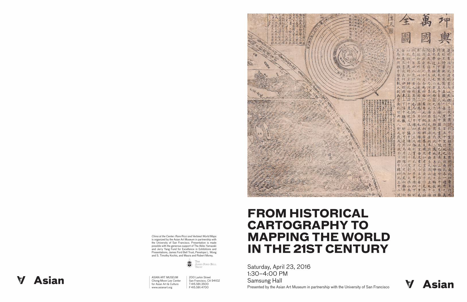
A Complete Map of the Ten Thousand Countries of the World, 1602, by Matteo Ricci (Italian, 1552–1610), with Li Zhizao (Chinese, 1565–1630), printed by Zhang Wentao (Chinese, dates unknown). China; Beijing. Six-panel woodblock print; ink on paper. Owned by the James Ford Bell Trust, held at the James Ford Bell Library, University of Minnesota.
MAP COLLECTIONS OF THE FAR EAST AT THE LIBRARY OF CONGRESSRALPH E. EHRENBERG, Library of Congress
One of the largest and most concentrated collections of maps of the Far East outside of China, Japan, and Korea is found in the Geography and Map Division of the Library of Congress. Since Emperor Tongzhi (同治皇帝) of the Qing Dynasty donated several maps to the Library of Congress in 1869, some 300,000 additional maps related to East Asia have been added to the Geography and Map Division’s collections. These date from a manuscript Atlas of the Ming Empire (Da ming yu di tu), circa 1536-1566, to the present, and represent all forms of cartographic materials ranging from stone rubbings, manuscripts, wood block prints, and panoramic landscape paintings on silk scrolls to printed topographic maps prepared by 20th century military mapmakers and the latest geospatial datasets. The origin and development of this collection will be briefly discussed with descriptions and illustrations of selected maps.
CHINA’S MARITIME CLAIMS: PERSPECTIVES FROM THE HISTORY OF CARTOGRAPHYLAURA HOSTETLER, Ricci Institute, University of San Francisco
In recent years China has staked claim to control of the waters of the South China Sea and jurisdiction of its uninhabited islands. China has further built up reefs off the coasts of the Philippines and Vietnam, transforming them into armed military bases. Strongly contested by neighboring countries, the legality of these actions is under consideration by the international court at The Hague. Taking a perspective informed by the history of cartography, Hostetler proposes a number of prec-edents useful for thinking about China’s actions, and poses questions about their implications for the way we think about jurisdiction over the seas.
THE TRANSFORMATIONAL POWER OF THE VANTAGE OF SPACE:NASA’S CONTRIBUTIONS TO CARTOGRAPHY AND INTERNATIONAL AND INTERCULTURAL EXCHANGESTEPHEN SANDFORD, NASA (former)
NASA’s first satellites focused on scientific and engineering objectives and opened the door for future advancements in earth observations for weather and climate prediction, pollution monitoring, land-use and ecosystem health studies on land and in the oceans. The complexity of early findings led to the creation of a systems framework that drives the multidisciplinary pursuit of Earth System Science. The view of Earth from space offers a unique perspective for scientists and for other scholars, politicians, and ordinary citizens around the world that promises to inspire us to greater international cooperation.
A GLOBAL SELFIE ED PARSONS, Google
In a period of only ten years our collective view of the world has been changed by the development of applications that have opened a window onto a massive and growing repository of images of our earth. It is now possible to view almost every square meter of the planet from above and from the ground, as if often the case innovations as much in business models as technology have made this possible and have changed society as a result. This talk will provide you some insight to those innovations.
RALPH EHRENBERG is the Chief of the Geography and Map Division of the Library of Congress and earlier directed the Cartographic Records Division of the U.S. NationalArchives. He received formal training from the U.S. Navy in aerial photography and received his B.A. and M.A. from the University of Minnesota. His goal in the Navy was “to film the world,” and his research focus has been on mapping it in vivid detail. His most recent books include Mapping the World, which was published by the National Geographic Society, and Mapping the West with Lewis and Clark, published by the Library of Congress and Levenger Press.
LAURA HOSTETLER is the EDS-Stewart Endowed Chair at the Ricci Institute, University of San Francisco, and a Professor in the Department of History at the University of Illinois at Chicago. She received her PhD in Asian and Middle Eastern Studies at the University of Pennsylvania. Her research interests include the history of cartography, empire, and encounters between Europe and Asia. Her seminal work is Qing Colonial Enterprise: Ethnography and Cartography in Early Modern China. Since she has also published The Art of Ethnography: A Miao Album of Guizhou Province.
ED PARSONS is the Geospatial Technologist of Google and co-chair of the W3C/OGC Spatial Data on the Web Working Group. He received his Master’s degree in Applied Remote Sensing from Cranfield Institute of Technology and is a fellow of the Royal Geographical Society. His research areas are human-computer interaction and visualization and information retrieval on the web. His most recent publication is The Map of the Future May Not Be a Map!
STEPHEN SANDFORD, formerly the NASA Langley Director for Space Technology and Exploration, is now Director of Systems Engineering at Stinger Ghaffarian Technologies. He received his Master’s degrees in both Electrical Engineering and Optical Sciences from the University of Virginia and the University of Arizona respec-tively. His research interests include system engineering and design and aerospace engineering. His recent work includes overseeing nearly 50 scientists and engineers for the Climate Absolute Radiance and Refractivity Observation (CLARREO) which will monitor the pulse of the earth to better understand climate change and helping plan NASA’s next steps in exploring the solar system including a mission to demonstrate methods to keep an asteroid from striking the Earth.
BIOGRAPHIES OF THE PRESENTERS:PRESENTATION ABSTRACTS: