Embed Size (px)
Citation preview

INFORMATION HANDOUT For Contract No. 01-0B2804
At DN-101-17.4
Identified by
Project ID 0112000112
MATERIALS INFORMATION Foundation Report for Log Fill Repair Wall dated October 2, 2014

Provide a safe, sustainable, integrated and efficient transportation system to enhance California’s economy and livability
State of California Business, Transportation and Housing Agency
DEPARMENT OF TRANSPORTATION
M e m o r a n d u m
To: MANODE KODSUNTIE Date: October 2, 2014 Structure Design Engineer File: 01-DN-101-PM 17.5 Design Branch 7 EFIS ID: 0112000112 Office of Bridge Design North & Central Retaining Wall No.: 01E0016
From: DEPARTMENT OF TRANSPORTATION DIVISION OF ENGINEERING SERVICES GEOTECHNICAL SERVICES OFFICE OF GEOTECHNICAL DESIGN NORTH – BRANCH B
Subject: Foundation Report for Log Fill Repair Wall
INTRODUCTION
This Foundation Report summarizes the results of the foundation investigation and provides geotechnical recommendations for a soldier pile and lagging wall with ground anchors on Route 101 at post mile (PM) 17.5 in Del Norte County, CA (Figure 1). The wall is required to repair a slope failure along the southbound edge of the highway.
PROJECT DESCRIPTION
The existing alignment was constructed in 1933 as a state highway (Contract 61TC1), and included a 9.9 mile realignment of the 1920’s era highway (from Last Chance to Flannigan’s) up onto the ridge and away from the previous narrow winding coastal alignment. The realignment was designed to limit the amount of tree removal. One of the techniques utilized at that time was to reuse the old growth that had to be felled in construction as fill material. This reduced the need for imported borrow, allowed for steeper fills that reduced the alignment footprint and eliminated costs associated with removing the timber. The Final Construction report for this project indicates that the constructed roadway width at this location was 37 feet, and the structural section was composed of 0.5 ft crusher run base with a 0.2 ft untreated crushed stone surface.

Manode Kodsuntie 01-DN-101 PM 17.5 October 2, 2014 01-0B280 Page 2 01-0112000112
Provide a safe, sustainable, integrated and efficient transportation system to enhance California’s economy and livability
A subsequent project in 1958 (Contract 59-1TC10) added six passing lane locations to this portion of the Redwood Highway, including a passing lane at the project site. Another project (01-062204) in 1966 slightly widened and repaved the highway north of Last Chance. The project site is a fill failure at one of the log fill locations in this realigned section. As-builts of the site do not specify the size of the logs and of the log fill. At the time of the storm damage event, the roadway consisted of three 12 foot lanes with two 4 foot paved shoulders. In March 2012, the southbound lane was abandoned and the centerline was shifted east to the lane line between the #1 and 2 NB lanes, creating a 2 lane highway.
The FHWA Damage Assessment Form (DAF) signed 7/13/2011 noted “Slipout/Sink Along Southbound Lane” and identified the assumed log fill failure area on the plan and profile damage sketch.
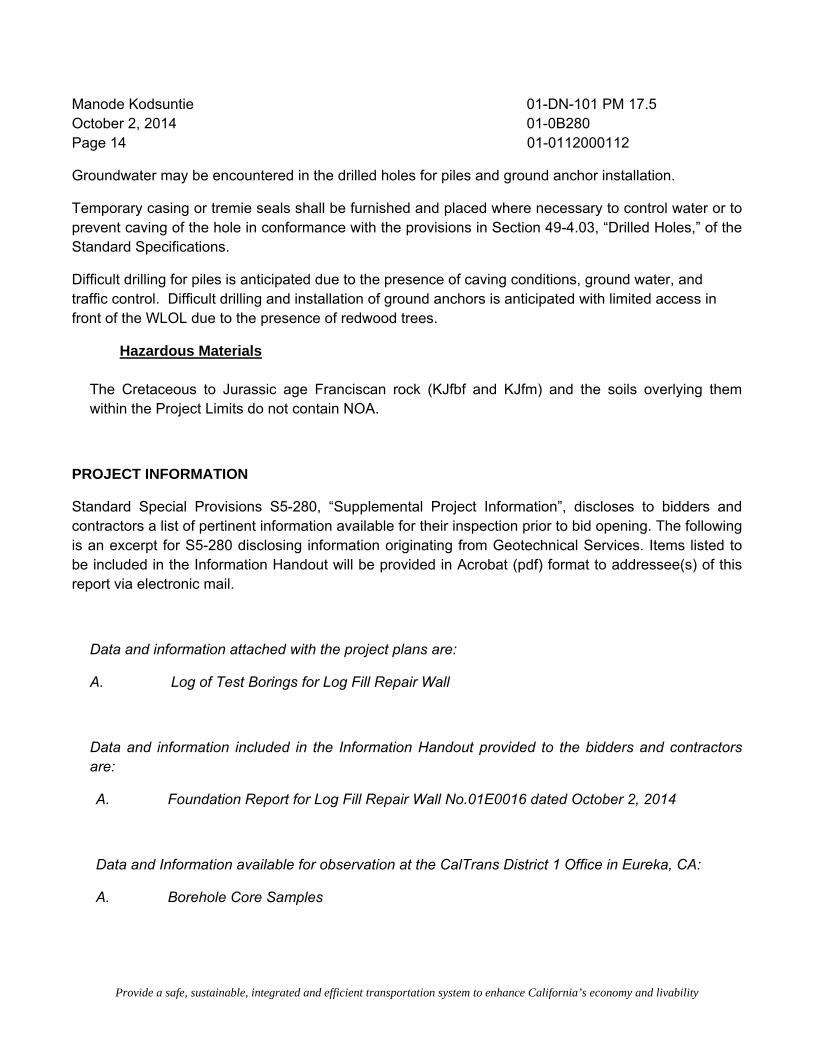
Construction photos of typical log fill structures from the 1933 highway construction are shown
below.
(Photos taken October 15, 2009)
The slope failure is characterized as a coastal bluff failure caused by heavy winter rains, coastal

Manode Kodsuntie 01-DN-101 PM 17.5 October 2, 2014 01-0B280 Page 3 01-0112000112
Provide a safe, sustainable, integrated and efficient transportation system to enhance California’s economy and livability
The slope failure is characterized as a fill failure of the log fill probably caused by deterioration of the logs in the roadway fill. At this location, District 1 plans to construct a soldier pile wall with ground anchors to repair the failing slope and support the roadway. The project scope includes restoring the tangent alignment, shoulder widening, and associated minor drainage improvements. The cross culverts located at PM 17.41 and 17.51 will be replaced. A location map showing the project location (Figure 1) and a Site Plan (Figures 2A and 2B) are attached.
The proposed wall is 500 feet in length with a maximum wall height of 25 feet. The restored alignment will consist of two 12 foot lanes with 8 foot SB and 6-8 ft NB paved shoulders.

Manode Kodsuntie 01-DN-101 PM 17.5 October 2, 2014 01-0B280 Page 4 01-0112000112
Provide a safe, sustainable, integrated and efficient transportation system to enhance California’s economy and livability
EXCEPTIONS
The recommendations contained in this report are based on a review of geotechnical/geologic literature, a subsurface investigation, laboratory testing of soil samples, geotechnical calculations and field observations.
Subsurface conditions were evaluated only at the boring locations and may deviate elsewhere within the Project Limits. The elevations reported in this memorandum are with respect to Mean Sea Level (MSL).
REFERENCES
“Childs Hill, Calif” (NE/4 Klamath 15’ Quadrangle) 7.5 Minute Quadrangle (Topographic) Map N4137.5-W12400/7.5, United States Geological Survey (USGS), 1966, Photoinspected 1975, map scale 1:24,000
Davenport, C.W., 1984, Geology and Geomorphic Features Related to Landsliding, Childs Hill 7.5' Quadrangle, Del Norte County, California: California Division of Mines and Geology Open-File Report OFR 84-7 S.F., map scale 1:24,000
US Department of Transportation, Federal Highway Administration – California Division, Damage Assessment Form (DAF) Title 23, Inspection date March 25, 2011.
Wills, C.J., 2000, Landslides in the Highway 101 Corridor Between Wilson Creek and Crescent City, Del Norte County, California: Department of Conservation, California Geologic Survey, Special Report 184
Caltrans Reports and Plans
01-DN-101-PM 17.5 FHWA Damage Assessment Form (DAF) CEP-CT01-003-0 (signed 07/13/2011)
Caltrans Corrosion Guidelines Version 2.0, 11/2012
Preliminary Caltrans Design Plans, dated 07/2012 Log Fill Repair Wall General Plan, dated 09/17/2013 Log Fill Repair Wall Unchecked Details, dated 08/06/2014
Caltrans Bridge Design Specifications Section 5, 8/2004
Caltrans Structure Design – Memo to Designers 5-12, dated July 2012 Caltrans Soil and Rock Logging, Classification, and Presentation Manual, 2010 Edition.
Caltrans As-Built Plans and District 1 Materials Laboratory Records (Various)

Manode Kodsuntie 01-DN-101 PM 17.5 October 2, 2014 01-0B280 Page 5 01-0112000112
Provide a safe, sustainable, integrated and efficient transportation system to enhance California’s economy and livability
California Division of Highways Final Construction Report for Contract 61TC1, dated February 9, 1935
FIELD INVESTIGATION AND TESTING PROGRAM A total of nine borings were completed between May 2012 and May 2013 (Figure 2). The borings were advanced using a truck mounted Acker MPCA drill rig using a 94-mm HXB casing equipped with a steel finger bit or diamond impregnated core bit.
Samples of the soil and bedrock from the borings were obtained by punch core, coring and a 1.4-inch (inside diameter) Standard Penetration Test (SPT) sampler driven with an automatic 140-pound hammer dropped 30 inches. The blows required to drive the samplers were recorded for each 6 inches of penetration or fraction thereof (ASTM D1586-11 Standard Test Method for Standard Penetration Test (SPT) and Split-Barrel Sampling of Soils).
Visual classifications were made in accordance to the Caltrans Soil and Rock Logging, Classification, and Presentation Manual 2010 Edition which conforms to ASTM D2488-09a Standard Practice for Description and Identification of Soils (Visual-Manual Procedure).
Slope inclinometer (SI) casings were installed in all borings. The annular space around the casings were backfilled with #8 sand, and the bottom 20 feet of the SI casings were perforated to allow groundwater measurement. The borings were completed at the surface with traffic-rated access boxes. Inclinometer readings were obtained between May 2012 and September of 2013. The boring locations and wall layout line are shown on Figures 2A and 2B. A summary of the borings and inclinometer monitoring results are summarized in Table 1. The SI data are included in Appendix A.
TABLE 1
BORING AND INCLINOMETER DATA SUMMARY
I.D. STATION/OFFSET
(“A” LINE)
DEPTH OF
BORING (ft, bgs)
SURFACE ELEVATION
(ft, MSL)
DATE COMPLETED
DEPTH TO TKfs ROCK
(ft, bgs)
DEPTH TO
FAILURE SURFACE
(ft, bgs)
RC-12-001 263+24.48
LT 17.48’ 40 1061.57 5/15/2012 20 N/A

Manode Kodsuntie 01-DN-101 PM 17.5 October 2, 2014 01-0B280 Page 6 01-0112000112
Provide a safe, sustainable, integrated and efficient transportation system to enhance California’s economy and livability
I.D. STATION/OFFSET
(“A” LINE)
DEPTH OF
BORING (ft, bgs)
SURFACE ELEVATION
(ft, MSL)
DATE COMPLETED
DEPTH TO TKfs ROCK
(ft, bgs)
DEPTH TO
FAILURE SURFACE
(ft, bgs)
RC-12-002 263+36.35
LT 22.23’ 40 1061.70 5/16/2012 28 20
RC-12-003 262+40.15
LT 14.15’ 60 1058.01 5/17/2012 21 N/A
RC-12-004 263+19.58
LT 25.50’ 50 1059.71 5/17/2012 302 12
RC-12-005 261+39.65
LT 17.48’ 60 1053.14 6/13/2012 23 8
RC-13-0061 261+89.65
RT 16.25’ 65 1055.4 5/08/2013 15 N/A
RC-13-0071 261+89.65
LT 16.55’ 99 1055.5 5/16/2013 41.5 22
RC-13-0081 263+49.66
LT 14.16’ 50 1062.0 5/22/2013 302 N/A
RC-13-0091 260+92.35
LT 22.47 60 1050.3 5/22/2-13 28 N/A
1Approximate STATION/OFFSET and SURFACE ELEVATION 2Approximate depth to bedrock

Manode Kodsuntie 01-DN-101 PM 17.5 October 2, 2014 01-0B280 Page 7 01-0112000112
Provide a safe, sustainable, integrated and efficient transportation system to enhance California’s economy and livability
LABORATORY TESTING
Laboratory testing of soil samples obtained from boring RC-08-001was performed at Caltrans’ Geotechnical Materials Laboratory in Sacramento, California. The following tests were performed:
Grading Analysis (CA Test Method No. 202)
Unit Weight
Moisture Content
Mechanical Analysis
Atterberg limits
Corrosivity test (pH and Resistivity) (CA Test Method No. 643)
Corrosivity tests (Chloride Content, Sulfate Content) (CA Test Method Nos. 422 and 417)
Test Results are included in Appendix B.
SITE GEOLOGY AND SUBSURFACE CONDITIONS
Site Description
Currently the road surface is approximately 38 feet wide with narrow to nonexistent NB shoulders and up to 12 foot wide SB shoulders. The head scarp of the slope failure is located within the SB shoulder and is closed to traffic with delineators. The wall layout line is near the hinge point of the failing slope (Figures 2A and 2B).
Site Geology
A geologic map of the area is provided in Figure 3. Bedrock within the project limits is mapped as Franciscan Mélange (KJfm) consisting of highly sheared shale and argillite near the contact with Cretatious to Jurassic age rock of the Franciscan Broken Formation (KJfbf) consisting of hard sandstone and sheared shale.
The bedrock at the site is gray to very dark gray, medium to fine-grained, slightly weathered to decomposed sandstone, mudstone and shale. The bedrock is overlain by Clayey SAND (SC) and Sandy CLAY with GRAVEL (CL).

Manode Kodsuntie 01-DN-101 PM 17.5 October 2, 2014 01-0B280 Page 8 01-0112000112
Provide a safe, sustainable, integrated and efficient transportation system to enhance California’s economy and livability
In addition to the numerous field reviews conducted by personnel from this Office, A site reconnaissance was performed by Tom Whitman of the Office of Geotechnical Design West in January of 2013. The consensus is that the deformation of the roadway is the result of a failure of the log fill, probably due to deterioration of the logs and migration of fill material through the logs. Although the log fill is locally oversteepened possibly indicating a foundation failure, no evidence of larger (global) instability was observed at the site.
Subsurface Conditions
The borings encountered 5 to 10 feet of AC, cold mix and road base material. Note that most borings were located in failed pavement areas within AC or cold mix patches. The asphalt concrete is underlain by up to 15 feet of native material recompacted as fill and consisting of Clayey SAND (SC) and Sandy CLAY with GRAVEL (CL). Beneath this was a similar in-place native material identified as Clayey SAND (SC) and Sandy CLAY with GRAVEL (CL). Voids were noted at various locations in these layers. These have been noted on the Subsurface Profile Along the Wall Layout Line (WLOL) (Figures 4A and 4B). There was little woody debris encountered in the borings.
The depth to bedrock ranges between 15 and 42 feet. The bedrock consists of interbedded sandstone, shale, siltstone and mudstone that ranges from fresh to very intensely weathered, soft to hard and moderately to very intensely fractured. Bedrock throughout all the borings contained layers of varying thicknesses that were decomposed.
Logs of Test Borings (LOTBs) will be provided at a future date to be included in the plans.
Groundwater Conditions
Groundwater levels were checked in the perforated SI casings installed in all borings during and after their installation. The groundwater measurements are reported in Table 2.
TABLE 2
WATER LEVEL MEASUREMENTS1
Date Measured
RC-12-
001 RC-12-
002 RC-12-
003 RC-12-
004 RC-12-
005 RC-13-
006 RC-13-
007 RC-13-
008 RC-13-
009
05/22/12 30 32.6 59.3 49.2
06/12/12 32.4 36.7 59.6 49.5
06/13/12 42.9

Manode Kodsuntie 01-DN-101 PM 17.5 October 2, 2014 01-0B280 Page 9 01-0112000112
Provide a safe, sustainable, integrated and efficient transportation system to enhance California’s economy and livability
Date Measured
RC-12-
001 RC-12-
002 RC-12-
003 RC-12-
004 RC-12-
005 RC-13-
006 RC-13-
007 RC-13-
008 RC-13-
009
10/10/12 36 dry dry dry
01/03/13 35.1 dry dry dry 38.9
05/09/13 45.1
05/23/13 28.0 44.0 87.0 37.0 38.0
06/25/13 35.6 45.3 47.1 85.6 36.7 44.1
06/27/13 35.7 dry
09/26/13 dry 34.2 46.0 85.3 37.6 44.4
Notes: 1 ‐ All water levels measured from the top of casings as feet below ground surface.
CORROSION EVALUATION
Chemical analyses were performed on samples collected from borings RC-13-006 and RC-13-007 to evaluate corrosion potential of the on-site soils. Testing was performed by the Caltrans Materials Laboratory and Corrosion Branch in Sacramento, CA and at the District1 Materials Laboratory in Sacramento, CA. Table 3 summarizes the test results.
TABLE 3
SOIL CORROSION TEST SUMMARY
BOREHOLE ID DEPTH
(ft, bgs)
pH MINIMUM RESISTIVITY
(ohm-cm)
IS SAMPLE CORROSIVE?
RC-13-007 10- 15 8.23 6908 NO
RC-13-007 26.5 - 30 4.46 6815 YES
RC-13-006 29 3.77 866 YES
The Corrosion Test Summary Report dated 11/22/2013 is included in Appendix B.
Based on the Caltrans Corrosion Guidelines (2003 version 1.0) and the laboratory test results, the site is corrosive to foundation elements.

Manode Kodsuntie 01-DN-101 PM 17.5 October 2, 2014 01-0B280 Page 10 01-0112000112
Provide a safe, sustainable, integrated and efficient transportation system to enhance California’s economy and livability
SEISMIC RECOMMENDATIONS
For LRFD seismic design criteria, we consulted Anoosh Shamsabadi from the Caltrans Office of Earthquake Engineering. A shear wave velocity of 278 m/s was determined from soil types and corrected SPT N values. Utilizing the Caltrans ARS Online tool (V2.3.06), we recommend using the USGS 5% in 50 years hazard (2008) curve, which yields a spectral acceleration of 0.5g at period T = 0 seconds. The horizontal seismic coefficient (Kh) is typically taken as 1/3 to 1/2 of the PGA; we recommend using Kh = 0.2 for LRFD Extreme Event analysis. We recommend a value for vertical seismic coefficient Kv =0.
The ARS online data sheet utilized is attached to this report as Appendix C.
GEOTECHNICAL AND FOUNDATION RECOMMENDATIONS
Wall Location and Height
We recommend a soldier pile wall with timber lagging and ground anchors wall be constructed to retain the roadway prism and the underlying soils. The wall layout line is shown on the attached Site Plan sheets (Figures 2A and 2B). The wall, as shown, will extend from roadway station 260+00 to station 265+00 for a wall length of 500 feet. The maximum wall height is 25 feet from top of wall to bottom of lagging. A Subsurface Profile Along the WLOL (Figures 4A and 4B) is provided.
Design Parameters
Soil strength parameters for design were determined by using the standard penetration test (SPT) N values, published correlations and laboratory data. The soil design parameters were determined from the slope stability program SLOPE/W 2007 using the critical cross section at Station 261+89.65 (“A” Line). Observed ground surface features and depth to the failure plane (from inclinometer data) were used to fix the entry, depth and exit points of the failure surface. A factor of safety of 1.0 was assumed for the existing slope. The Spenser method of limit equilibrium that satisfies both force and moment equilibrium was used for this back analysis. The soil and rock parameters are provided in Table 4.

Manode Kodsuntie 01-DN-101 PM 17.5 October 2, 2014 01-0B280 Page 11 01-0112000112
Provide a safe, sustainable, integrated and efficient transportation system to enhance California’s economy and livability
TABLE 4
Soil Design Parameters
See the attached Subsurface Profile Along the WLOL (Figures 4A and 4B) and Design Cross Section (Figure 5) for subsurface material representation.
Hydrostatic Forces
For wall design we recommend that the groundwater level be assumed to be at bottom of lagging.
Design pressures should be based on moist unit weights of the soil above the groundwater surface and saturated unit weights should be applied below the groundwater surface.
Lateral Earth Pressure
The recommended active earth pressure is based on Caltrans Bridge Design Specifications, Section 5 - Retaining Walls (August 2004) and Caltrans Memo to Designers 5-12, Earth Retaining Systems Using Ground Anchors (July 2012). The active earth pressure distribution diagram was developed based on
LAYER
APPROXIMATE THICKNESS
(at WLOL)
(ft)
TOTAL UNIT
WEIGHT
(pcf)
ANGLE OF INTERNAL FRICTION
(degrees)
COHESION
(c, psf)
AC/Cold Mix/Base 5-10 120 32 0
Clayey SAND and Sandy CLAY with GRAVEL
5-25 110 32 140
BEDROCK Interbedded Sandstone/Shale
20-50 135 35 200

Manode Kodsuntie 01-DN-101 PM 17.5 October 2, 2014 01-0B280 Page 12 01-0112000112
Provide a safe, sustainable, integrated and efficient transportation system to enhance California’s economy and livability
a soldier pile wall with a maximum height of 25 feet and ground anchors located at 7 feet and 17 feet below top of wall.
Recommended active lateral earth pressures for the wall design are given in Table 5. The pressures are derived from the following soil parameters which are for the two soil layers in Table 4 combined:
coefficient of active lateral earth pressure (ka) = 0.31 unit weight of soil(ɣ) = 115 pcf, soil friction angle (ɸ) = 32° cohesion (c) = 0 psf
Additional wall conditions based on a 20 foot wall section with one ground anchor located 7 feet below top of wall and a 12 foot high cantilever wall section were also developed. These unfactored values are provided in Table 5.
TABLE 5
Design Active Earth Parameters
Wall Height (H)
(feet)
Anchor 1 (H1)
(feet below top of wall)
Anchor 2 (H2)
(feet below top of wall)
Active Lateral Earth Pressure Resultant acting on Wall Height H per unit
width of wall
Pa
(Kips/Ft)
25 7 17 11.4
20 7 N/A 7.1
12 N/A N/A 2.6

Manode Kodsuntie 01-DN-101 PM 17.5 October 2, 2014 01-0B280 Page 13 01-0112000112
Provide a safe, sustainable, integrated and efficient transportation system to enhance California’s economy and livability
Pile Length and Embedment
We recommend all piles extend a minimum of 10 feet into bedrock. All piles should be a minimum length of 40 feet, except for those from Station 161+80 through162+28 (“A” Line). These piles (# 22 through #28) should be a minimum length of 55 feet.
Ground Anchors
Ground anchors are assumed to be at 7 feet and 17 feet below the top of wall at an inclination of 20o from horizontal (based on Log Fill Repair Wall General Plan dated 9-27-13). We recommend that the upper row of ground anchors have an unbounded length of 40 feet, and the lower row of ground anchors have an unbounded length of 30 feet.
EARTH WORK AND WALL BACKFILL RECOMMENDATIONS
The wall is designed so that the design height H provides a berm in front of the wall face at least 4 feet wide measured from the face of the wall and provides a design grade at least 2 feet below finished grade measured at the face of the wall (Caltrans Bridge Design Specifications, 5.8.6.1). It is anticipated that portions of the fill slope below the roadway will be removed to construct the wall.
To assure adequate wall drainage, shims should be placed between the timber lagging in conjunction with free-draining backfill material.
RIPPABILITY
Based on the boring logs and field observations, we expect the material within the anticipated limits of excavation to be rippable. The boring locations are shown in Figure 2.
CONSTRUCTION CONSIDERATIONS
The typical sequence of Soldier Pile Wall installation shall follow the Structure Plans and the Special Provisions for this project.
Excavation and Drilling Difficulties
Caving conditions may be encountered during drilling holes for piles and for ground anchor installation due to the granular soils and the very intensely fractured rock.
Manode Kodsuntie 01-DN-101 PM 17.5 October 2, 2014 01-0B280 Page 14 01-0112000112
Provide a safe, sustainable, integrated and efficient transportation system to enhance California’s economy and livability
Groundwater may be encountered in the drilled holes for piles and ground anchor installation.
Temporary casing or tremie seals shall be furnished and placed where necessary to control water or to prevent caving of the hole in conformance with the provisions in Section 49-4.03, “Drilled Holes,” of the Standard Specifications.
Difficult drilling for piles is anticipated due to the presence of caving conditions, ground water, and traffic control. Difficult drilling and installation of ground anchors is anticipated with limited access in front of the WLOL due to the presence of redwood trees.
Hazardous Materials
The Cretaceous to Jurassic age Franciscan rock (KJfbf and KJfm) and the soils overlying them within the Project Limits do not contain NOA.
PROJECT INFORMATION
Standard Special Provisions S5-280, “Supplemental Project Information”, discloses to bidders and contractors a list of pertinent information available for their inspection prior to bid opening. The following is an excerpt for S5-280 disclosing information originating from Geotechnical Services. Items listed to be included in the Information Handout will be provided in Acrobat (pdf) format to addressee(s) of this report via electronic mail.
Data and information attached with the project plans are:
A. Log of Test Borings for Log Fill Repair Wall
Data and information included in the Information Handout provided to the bidders and contractors are:
A. Foundation Report for Log Fill Repair Wall No.01E0016 dated October 2, 2014
Data and Information available for observation at the CalTrans District 1 Office in Eureka, CA:
A. Borehole Core Samples

Manode Kodsuntie 01-DN-101 PM 17.5 October 2, 2014 01-0B280 Page 15 01-0112000112
Provide a safe, sustainable, integrated and efficient transportation system to enhance California’s economy and livability
If you have any questions or need additional information, please contact Kathy Gallagher at (707) 441-2024 or Charlie Narwold at (707) 445-6036.
KATHY GALLAGHER CHARLIE NARWOLD Transportation Engineer Senior Engineering Geologist Office of Geotechnical Design North Office of Geotechnical Design North
List of Figures
Figure 1 - Vicinity Map
Figures 2A and 2B - Site Plan
Figure 3 - Project Geologic Map
Figures 4A and 4B- Subsurface Profile Along the WLOL
Figure 5 - Design Cross Section
Appendices
Appendix A: Slope Inclinometer Monitoring Results
Appendix B: Laboratory Test Summary and Data Sheets
Appendix C: ARS Online Data Sheet
C: RMahallati (E-copy)
GS File Room (email [email protected])
Structure Construction RE Pending File (email [email protected])
Project Manager


Design X-Section March 2014.dgn 3/26/2014 6:33:19 PM

APPENDIX A SLOPE INCLINOMETER MONITORING RESULTS

RESULT OF SI MONITORING
01-DN-101-PM17.5
Site: Humboldt Crossing RC-12-001
E.A.: 0112000112/230
Depth of casing: 37 ft
A0 direction (magnetic north): 210 deg.
Location: N41°40'06.0'',W124°06'47.8''
RC-12-001, A-Axis
0
5
10
15
20
25
30
35
40
Dep
th in
feet
-1.00 -0.50 0.00 0.50 1.00
Cumulative Displacement (in) from 5/23/2012
5/23/20126/12/201210/10/20121/3/20136/27/20139/26/2013
RC-12-001, B-Axis
0
5
10
15
20
25
30
35
40
Dep
th in
feet
-1.00 -0.50 0.00 0.50 1.00
Cumulative Displacement (in) from 5/23/2012
5/23/20126/12/201210/10/20121/3/20136/27/20139/26/2013

RESULT OF SI MONITORING01-DN-101-PM17.5Site: Humboldt Crossing RC-12-002E.A.: 0112000112/230
Depth of casing: 39.0 ftA0 direction (magnetic north): 250 deg.Location: N41°40'05.7'',W124°06'47.1''
RC-12-002, A-Axis
5/23/2012 5/23/20125/23/2012 6/12/201210/10/2012 1/3/20135/23/2013 6/25/20139/26/2013 11/21/2013
Dep
th in
Fee
t
0
2
4
6
8
10
12
14
16
18
20
22
24
26
28
30
32
34
36
38
Profile Change in InchesCorrections: Bias: Rotation
-3-2.5-2-1.5-1-0.50 0.51 1.5 2 2.53
RC-12-002, B-Axis
5/23/2012 5/23/20125/23/2012 6/12/201210/10/2012 1/3/20135/23/2013 6/25/20139/26/2013 11/21/2013
Dep
th in
Fee
t
0
2
4
6
8
10
12
14
16
18
20
22
24
26
28
30
32
34
36
38
Profile Change in InchesCorrections: Bias: Rotation
-3-2.5-2-1.5-1-0.50 0.51 1.5 2 2.53

RESULT OF SI MONITORING
01-DN-101-PM17.5
Site: Humboldt Crossing RC-12-003
E.A.: 0112000112/230
Depth of casing: 60 ft
A0 direction (magnetic north): 262 deg.
Location: N41°40'05.9'',W124°06'47.6''
RC-12-003, A-Axis
0
10
20
30
40
50
60
Dep
th in
feet
-1.00 -0.50 0.00 0.50 1.00
Cumulative Displacement (in) from 5/23/2012
5/23/20126/12/201210/10/20121/3/20136/27/20139/26/2013
RC-12-003, B-Axis
0
10
20
30
40
50
60
Dep
th in
feet
-1.00 -0.50 0.00 0.50 1.00
Cumulative Displacement (in) from 5/23/2012
5/23/20126/12/201210/10/20121/3/20136/27/20139/26/2013

RESULT OF SI MONITORING
01-DN-101-PM17.5
Site: Humboldt Crossing RC-12-004
E.A.: 0112000112
Depth of casing:
A0 direction:
Location:
RC-12-004, A-Axis
0
5
10
15
20
25
30
35
40
45
50
Dep
th in
feet
-3.0 -2.0 -1.0 0.0 1.0
Cumulative Displacement (in) from 5/23/2012
5/23/20126/12/201210/10/20121/3/2013
RC-12-004, B-Axis
0
5
10
15
20
25
30
35
40
45
50
Dep
th in
feet
-1.0 0.0 1.0 2.0
Cumulative Displacement (in) from 5/23/2012
5/23/20126/12/201210/10/20121/3/2013

RESULT OF SI MONITORING
01-DN-101-PM17.5
Site: Humboldt Crossing RC-12-005
E.A.: 0112000112/230
Depth of Casing:
A0 direction:
Location:
RC-12-005, A-Axis
0
10
20
30
40
50
60
Dep
th in
feet
-2.0 -1.0 0.0 1.0
Cumulative Displacement (in) from 6/13/2012
6/13/201210/10/20121/3/20135/23/20136/25/20139/26/2013
RC-12-005, B-Axis
0
10
20
30
40
50
60
Dep
th in
feet
-1.00 -0.50 0.00 0.50 1.00
Cumulative Displacement (in) from 6/13/2012
6/13/201210/10/20121/3/20135/23/20136/25/20139/26/2013

RESULT OF SI MONITORING01-DN-101-PM17.5Site: Humboldt Crossing RC-12-006E.A.: 0112000112/230
Depth of Casing: 59 ftA0 direction (magnetic north): 246 deg.Location: N41°40'05.6'',W124°06'46.3''
RC-13-006, A-Axis
5/9/2013 5/9/20135/9/2013 6/25/20131/2/2014
Dep
th in
Fee
t
0
2
4
6
810
12
14
1618
20
22
2426
28
30
3234
36
38
4042
44
46
4850
52
54
5658
Profile Change in Inches-1 -0.5 0 0.5 1
RC-13-006, B-Axis
5/9/2013 5/9/20135/9/2013 6/25/20131/2/2014
Dep
th in
Fee
t
0
2
4
6
810
12
14
1618
20
22
2426
28
30
3234
36
38
4042
44
46
4850
52
54
5658
Profile Change in Inches-1 -0.5 0 0.5 1

RESULT OF SI MONITORING01-DN-101-PM17.5Site: Humboldt Crossing RC-13-007E.A.: 0112000112/230
Depth of Casing: 98.5 ftA0 direction (magnetic north): 315 deg.Location: N41°40'05.4'',W124°06'46.7''
RC-13-007, A-Axis
5/23/2013 5/23/20135/23/2013 6/25/20139/26/2013 11/21/2013
Dep
th in
Fee
t
0
5
10
15
20
25
30
35
40
45
50
55
60
65
70
75
80
85
90
95
100
Profile Change in InchesCorrections: Bias: Rotation
-1 -0.5 0 0.5 1
RC-13-007, B-Axis
5/23/2013 5/23/20135/23/2013 6/25/20139/26/2013 11/21/2013
Dep
th in
Fee
t
0
5
10
15
20
25
30
35
40
45
50
55
60
65
70
75
80
85
90
95
100
Profile Change in InchesCorrections: Bias: Rotation
-1 -0.5 0 0.5 1

RESULT OF SI MONITORING01-DN-101-PM17.5Site: Humboldt Crossing RC-13-008E.A.: 0112000112/230
Depth of Casing: 56 ftA0 direction (magnetic north): 254 deg.Location: N41°40'06.6'',W124°06'50.0''
RC-13-008, A-Axis
5/23/2013 5/23/20135/23/2013 6/25/20139/26/2013 11/21/2013
Dep
th in
Fee
t
02468
1012141618202224262830323436384042444648505254
Profile Change in Inches-1 -0.5 0 0.5 1
RC-008, B-Axis
5/23/2013 5/23/20135/23/2013 6/25/20139/26/2013 11/21/2013
Dep
th in
Fee
t
02468
1012141618202224262830323436384042444648505254
Profile Change in InchesCorrections: Bias: Rotation
-1 -0.5 0 0.5 1

RESULT OF SI MONITORING01-DN-101-PM17.5Site: Humboldt Crossing RC-13-009E.A.: 0112000112/230
Depth of Casing: 59 ftA0 direction (magnetic north): 276 deg.Location: N41°40'04.3'',W124°06'44.3''
RC-009, A-Axis
5/23/2013 5/23/20135/23/2013 6/25/20139/26/2013 11/21/2013
Dep
th in
Fee
t
0
2
4
6
810
12
14
1618
20
22
2426
28
30
3234
36
38
4042
44
46
4850
52
54
5658
Profile Change in Inches-1 -0.5 0 0.5 1
RC-009, B-Axis
5/23/2013 5/23/20135/23/2013 6/25/20139/26/2013 11/21/2013
Dep
th in
Fee
t
0
2
4
6
810
12
14
1618
20
22
2426
28
30
3234
36
38
4042
44
46
4850
52
54
5658
Profile Change in Inches-1 -0.5 0 0.5 1

APPENDIX B LABORATORY TEST SUMMARY AND DATA SHEETS


AG
1303
575/
7/20
1310
/30/
2013
SO
ILC
6381
38
RG
-13-
06,#
5
11/5
/201
3
100
100
100
100
100
100
100
100
99
Tes
tMet
hod
CT
205
Rem
arks
:Sam
ple
sent
toso
ilsla
bfo
rfu
rthe
rte
stin
g..

AG
1303
585/
7/20
1310
/30/
2013
SO
ILC
6381
39
RC
-13-
006,
#6
11/5
/201
3
100
100
100
100
100
100
99 98 87
Tes
tMet
hod
CT
205
Rem
arks
:Sam
ple
sent
tobo
thC
orro
sion
and
Soi
lsla
bfo
rfu
rthe
rte
stin
g.

AG
1303
555/
14/2
0110
/30/
2013
SO
ILC
6381
34
RC
-13-
007,
#1&
2#1
&2
11/5
/201
3
100
100
100
100
100
98 92 80 55
6033
Tes
tMet
hod
CT
205
Rem
arks
:Sam
ple
was
shor
tmat
eria
lfor
Soi
lsLa
bte
stin
g.
Not
e:If
corr
osio
nte
stin
gw
asre
ques
ted,
the
sam
ple
has
been
proc
esse
dan
dse
ntto
Cor
rosi
onfo
rC
T41
7,42
2an
d64
3.

AG
1303
565/
14/2
013
10/3
0/20
13S
OIL
C63
8136
RC
-18-
007,
#4
11/5
/201
3
100
100
100
100
100
100
100
100
99
Tes
tMet
hod
CT
205
Rem
arks
:Sam
ple
sent
tobo
thC
orro
sion
and
Soi
lsla
bfo
rfu
rthe
rte
stin
g..

Results sent to:
Division of Engineering Services
Materials Engineering and Testing Services
Corrosion and Structural Concrete Field Investigation Branch
KATHY GALLAGHER
Report Date: 11/22/2013
Reported by Michael Mifkovic
EA
EFIS:
Dist/Co/Rte/PM
0112000112
01 / DN /101/ / 17.5 PM
CORROSION TEST SUMMARY REPORT ‐SOIL
CORROSION LAB #
MINIMUM RESISTIVITY¹
pH¹(ohm‐cm)BORE #TL101 # IS SAMPLE CORROSIVE?
DEPTH (FT)
START END
CHLORIDE CONTENT²
(ppm)
SULFATE CONTENT³
(ppm)
SOIL SAMPLE FROM:
6908 8.2310 15CR20130385 RC‐13‐007C638134 NO
6815 4.46 13 25026.5 30CR20130386 RC‐13‐007C638136 YES
866 3.77 2 233029 29CR20130387 RC‐13‐006C638139 YES
• pH is 5.5 or less
• Sulfate concentration is 2000 ppm or greater
Controlling corrosion parameters are as follows:
This site is corrosive to foundation elements (see note below).
Note: For Structural Elements, the Department considers a site corrosive if one or more of the following conditions exist: pH is 5.5 or less, chloride concentration is 500 ppm or greater, sulfate concentration is 2000 ppm or greater. Resistivity is not considered for Structural Elements. MSE backfill shall conform to the requirements of section 47-2.02C Structure Backfill in the 2010 Standard Specifications.
¹CT 643, ²CT 422, ³CT 41711/22/2013CR20130385 ‐ CR20130387

APPENDIX # ARS Online Data Sheet

This web-based tool calculates both deterministic and probabilistic acceleration response spectra for any location in California based on criteria provided in Appendix B of Caltrans Seismic Design Criteria. More...
Caltrans ARS Online (v2.3.06)
SELECT SITE LOCATION
Latitude: 41.668025 Longitude: -124.113086 VS30: m/s278 Calculate
CALCULATED SPECTRA Display Curves: 3
M ap data © 2014 GoogleReport a m ap error
Reference Vs30 Values(From NEHRP): B=760m/s C=560m/s D=270m/s
Page 1 of 2ARS Online
5/15/2014http://dap3.dot.ca.gov/ARS_Online/index.php

Conditions of Use | Privacy Policy Copyright © 2009 State of California
Page 2 of 2ARS Online
5/15/2014http://dap3.dot.ca.gov/ARS_Online/index.php


![A probabilistic model of weld penetration depth …...penetration depth Prob[y>y 0] Probability of satisfying y>y μy Mean of penetration depth σy Standard deviation of penetration](https://img.pdfslide.us/doc/110x75/5ea8ab9f21b75f2a2f7f030e/a-probabilistic-model-of-weld-penetration-depth-penetration-depth-probyy.jpg)