Embed Size (px)
Citation preview

WEST OF MAIN PARADEFocused Cultural Landscape Report
JUNE 2011


CONTENTS
INTRODUCTION
A. Introduction, Purpose of Study and Planning Context
B. Methodology
C. Description of Study Boundaries
PART 1. SITE HISTORY, EXISTING CONDITIONS, ANALYSIS & EVALUATION
A. Site History
A.1 Chronology of Events
A.2 Historic Periods
A.3 Historic Period Maps
A.4 Historic Photographs
B. Existing Conditions
B.1 Physical Setting
B.2 Access and Circulation
B.3 Land Use
B.4 Vegetation
B.5 Archaeological Resources
B.6 Building and Structures
C. Analysis & Evaluation
C.1 Defining Significance
C.2 Analysis
C.3 Assessing Historic Integrity
PART 2. TREATMENT
BIBLIOGRAPHY
Note: The Plant Inventory will be provided as a separate document to accompany both the West of Main Parade Focused CLR and the Main Post CLR.

Established by Spain in 1776, the Presidio is the birthplace of San Francisco. After having declared its independence from Spain in 1821, Mexico flew its flag over the post until 1846 when John C. Fremont took possession of the Presidio and claimed California for the United States. By order of President Millard Fillmore, in 1850 the U.S. Army established a command center in the Presidio, which eventually became the headquarters for the Division of the Pacific. Inspired by the City Beautiful movement and the parks of Olmsted, the Army adhered to a picturesque aesthetic in developing the Presidio with winding, tree-lined boulevards, forested ridges, and formally landscaped entrances. By World War II, the Presidio was one of the nation’s pre-eminent military installations.
The Presidio was designated a National Historic Landmark in 1962, and in 1972 Congress identified it as a future national park site should it no longer be needed by the Army. The Base Realignment and Closure Commission identified the historic post for closure in 1989, and the Army left in 1994.
The historic buildings and landscapes that distinguish the Presidio also present financial and management challenges that are unique among national parks. In response to these challenges, Congress established a new model for managing this particular site as a financially self-sustaining national park. The Presidio Trust Act was passed in 1996, transferring jurisdiction of the Presidio’s interior lands and more than 700 of its buildings to the Presidio Trust. The Trust’s mission is to preserve the Presidio as an enduring resource for the American people. The Trust works closely with the National Park Service and the Golden Gate National Parks Conservancy in managing the Presidio and protecting its resources.

INTRODUCTION
The purpose of this study is to document the cultural landscape within the West of Main Parade cluster area (see Figure A). It will look at the historic development, and discuss the existing conditions for the cluster area. It will analyze the features within the cluster area for their historic significance and integrity, and based on this analysis, will make treatment recommendations. The Presidio Trust completed a two-part cultural landscape assessment of the Main Post in 2002, called Principles for the Future: Cultural Landscape Assessment of the Main Post, and is currently updating this material to produce a new Cultural Landscape Report (CLR) for the entire Main Post. The West of Main Parade cluster area is part of the Main Post and would normally be analyzed within the Main Post CLR. However, the Presidio Trust has decided to focus on the West of Main Parade cluster area now, in advance of the completion of the Main Post CLR, in order to meet the schedule requirements for certain key projects. These projects include:
• TheTaylorRoadParkingLot-aproposedupgrade to increase parking capacity (related to the removal of cars from the Main Parade), and to improve circulation, storm drainage and other functional aspects of the existing parking facility defined by Taylor Road, Ord Street, and the area adjacent to it.
A. INTRODUCTION, PURPOSE OF STUDY AND PLANNING CONTEXT
Figure AAerial view of the Main Post with the City of San Francisco in the backdrop.
WEST OF MAIN PARADE
MAIN PARADE
COMMUNITYDISTRICT
OLD PARADE
FUNSTON AVENUE
HALLECK STREET
MAIN POST BLUFF
EL PRESIDIO
INFANTRY TERRACE
Figure ACluster areas within the Main Post.
Introduction

• AdditiontothePresidioChapel—asdefinedin the Main Post Update (November 2010), an addition of approximately 4,000 square feet will be added to the west side of the chapel, and its landscape will be reconfigured to provide outdoor gathering and worshipping spaces on its east side. Reconfiguration of the existing parking facility west of the chapel is also anticipated due to the placement of the addition.
• RileyAvenueLandscapeImprovements—includesrehabilitationofthelandscapearound the six residential buildings on Riley Avenue.
The West of Main Parade Focused CLR follows the format recommended by Chapter 7 of NPS 28: Cultural Resource Management Guideline. It is being prepared and reviewed under Stipulation K of the Programmatic Agreement for the Main Post Update (PA-MPU) in order to satisfy cultural landscape analysis requirements for the Taylor Road Parking Lot and Chapel projects. In preparing this “focused cultural landscape study” the Trust is exercising its option to do so under Stipulation II.B.1. of the PA-MPU. The findings of the West of Main Parade Focused CLR will be incorporated into the district-wide Main Post CLR, which is being prepared and reviewed separately.
There are several Presidio planning documents that provide the planning context for creating the West of Main Parade Focused CLR. The 2002 Principles for the Future: Cultural Landscape Assessment of the Main Post, developed the idea of looking at the Main Post in terms of cluster areas of similar buildings. It described historic development of these cluster areas and presented guidelines and concepts for landscape treatment. The Presidio Trust Management Plan (PTMP, 2002) includes general concepts and planning guidelines for the Main Post, including this cluster area. The Main Post Update from November 2010 identifies the Taylor Road area for parking improvements, and provides Project Parameters for designing an addition to the Presidio Chapel. Both projects were included in consultation over several years with the National Park Service, the California Office of Historic Preservation, the Advisory Council on Historic Preservation, as well as community and preservation organizations, and members of the public as part of the Section 106 consultation for the Main Post Update. And finally, the Main Post Planning and Design Guidelines, (released in June 2011) contains design guidelines for the West of Main Parade cluster area.
B. METHODOLOGY
The scope of work and boundaries for the West of Main Parade cluster area was developed by Presidio Trust planning staff. The project team includes a Historic Landscape Architect, Historic Architect, Urban Planner, and Historic Preservation Specialist. Several assumptions have been made that affect the scope of this Focused CLR:
1. Because there is a large volume of research and documentation relating to the history and existing conditions of the Main Post, no additional historical research was undertaken for this project.
2. The majority of the historic graphic materials used for this document come from the Park Archives and Record Center, including historic photographs and maps and building plans. Additional historic photographs were also found in the San Francisco Public Library’s San Francisco History Center. Historic aerial photographs were provided by HJW Geospatial, Pacific Aerial Surveys (A division of Photo Science Inc.) A reference list of sources is included in the Bibliography section.
West of Main Parade Focused Cultural Landscape Report2

C. DESCRIPTION OF STUDY BOUNDARIES
The West of Main Parade cluster area is an artificial boundary created as a management tool for the purposes of organization, description and inventory. It is not a designation that existed historically. It is one of nine Main Post cluster areas that have been identified to facilitate planning work. The West of Main Parade cluster area consists of four major parts:
•PresidioChapelandGoldenGateClub
•RileyAvenueresidentialarea•Backs of the Montgomery Street barracks,
Taylor Road and Ord Street•Taylor Road and Infantry Terrace south of
Sheridan
These areas are related by proximity but each has a separate history and a separate visual identity.
The steel gates and stone boundary wall of the National Cemetery are excluded from the cluster area because they are not administered by the Presidio Trust and have a separate history.
Within this cluster area, there are areas of historic forest. The historic forest was planted by the Army throughout the Presidio’s largely open lands starting in the 1880’s to provide wind protection, to define site boundaries, and to beautify the Amry Post. Eucalyptus, Monterey Cypress, and Monterey Pine were the three tree species most commonly used to create this forest.
Figure B: 2010Existing Conditions
Presidio Chapel and Golden Gate Club
Riley Avenueresidential area
Back of Montgomery Street barracks,Taylor Road and Ord Street
Taylor Road and Infantry
Terrace south of Sheridan
Introduction 3

4 West of Main Parade Focused Cultural Landscape Report
PART 1: SITE HISTORY, EXISTING CONDITIONS, ANALYSIS & EVALUATIONA. SITE HISTORY
A.1 Chronology of Events
DATE EVENT
1870 Lincoln Boulevard started construction. Portions completed between 1880 and 1909.
1880 Sheridan Avenue constructed.
1885 Building 116 (Post trader [sutler]) constructed.
1886 Army Major W.A. Jones’ 1883 tree planting plan implemented and continued throughut the 1890s and early 1900s. The most commonly planted tree species included blue gum eucalyptus, Monterey pine, Monterey cypress, and blackwood acacia.
1895 Building 101 (Barracks and mess hall) constructed. Taylor Road constructed.
1896 Buildings 102 and 103 (Barracks and mess hall) constructed.
1897 Buildings 104 and 105 (Barracks and mess hall) constructed.
1904 Building 122 (Gymnasium) constructed.
1909 Building 100 (Barracks and mess hall), Building 106 (band barracks), and Buildings 124, 125 and 126 (enlisted family quarters) constructed. Infantry Terrace road constructed
1911 Building 107 (switching station) constructed.
1912 Ord Street, Riley Avenue, and Fisher Loop roads constructed.
1930 Building 123 (Garage) constructed. Building 117 (classroom) constructed and later demolished.
1931 Buildings 127, 128 and 129 (enlisted family quarters) constructed.
1932 Building 130 (Presidio Chapel) constructed.
1940 Buildings 113 and 118 (five-vehicle garages) and Building 108 (storage, electric shop) constructed. Building 112 (machine gun shed) constructed and later demolished.
1941 Bliss Road constructed.
1949 Building 135 (enlisted men’s service club; later non-commissioned officers’ club) constructed.
1959 Non-contributing Building 114 (transformer - structure; concrete, cyclone fence) constructed.
1968 Non-contributing Building 109 (transformer - structure; reinforced concrete slab with cyclone fence) constructed.
1970s Non-contributing Building 119, 120 and 121 (storage sheds - much later replacements concrete foundation, wood walls, shed roof) constructed.

5
A.2 Historic Periods
Pre-Contact
The Native Ohlone are known to have inhabited the southern portions of the San Francisco bay area for thousands of years. One shell mound site, known archaeologically as SFr-6/26 or the Presidio Mound, is located along the historic tidal marsh at Crissy Field below the Main Post bluff, north of the cluster area being studied. This site was first recorded in 1912, and again in 2002. Often Native Californian sites are located close to the intersection of several ecological niches thus allowing the pre-historic
residents of those sites quick access to a variety of resources. This particular shell mound site was located along the marsh, adjacent to the spring-fed riparian corridor. The present-day cluster area would have provided close-by upland scrub habitat to the shell mound site. If typical demographic estimates for San Francisco bayside villages are applied to this Presidio site, then one can imagine that this general area would have been a hub of daily or seasonal activity for several hundred people between 750-1350 CE.
Spanish-Mexican Period
Once El Presidio was established in 1776 the pre-existing landscape was extensively altered by newly arrived Europeans. In very general terms the landscape was denuded of much of its vegetation through the work of the colonists searching for readily available building materials and fuel. More destructive than the colonists were the herds of cattle and other domesticated animals they introduced onto the site searching out food. Into this transitional landscape, the new military garrison began taking shape. Cutting across the cluster area was a road of unknown quality leading west from El Presidio to the Castillo of San Joaquin at the narrow straits of the bay. This road was very likely a precursor to the present-day Lincoln Boulevard and followed the same corridor. Located at the northern end of the cluster area was a cemetery described as a “Spanish and Indian Cemetery” by the US Army on some of the earliest maps of the military reservation. Its rather distant location from the main settlement at El Presidio is unusual, because routinely the dead were interred in sanctified grounds near established presidio chapels or mission churches. The documentary record is inconclusive regarding how this cemetery was treated by the US Army in advance of constructing either the Laundresses’ Quarters or the Montgomery Street Barracks.
Figure A-11816 drawing by Louis Choris.
Part 1: Site History, Existing Conditions, Analysis & Evaluation
6 West of Main Parade Focused Cultural Landscape Report
U.S. Army 1850-1989
When the first U.S. Army troops entered the then deserted Presidio in 1847 they immediately occupied the existing collection of adobe structures around the original El Presidio site. Slowly the character of the post was transformed with the addition of wood frame buildings which were better suited for the local conditions. Wood construction material was readily available and was used to create a number of early structures in the immediate vicinity of the original Spanish-Mexican garrison. A more aggressive phase of construction activity commenced with the Civil War in 1861. More substantial wood frame buildings started to appear around the El Presidio site and eventually into the cluster area site during the years between 1861 and 1865.
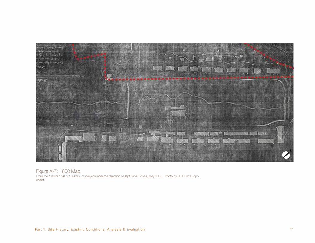
In 1870 the present-day Main Parade was still an open area with a naturally-occurring seasonal creek flowing down its middle from the south toward the bay. Building development within the cluster area was limited to a row of buildings fronting the present-day Montgomery Street. These were a collection of small scale wooden structures known as the laundresses’ quarters (built 1861-1865, removed c1893-1895), running north/south and parallel to the future alignments of Anza and Graham to the east. Thesestructures—includinganearliersutler’s,orposttrader’s,residence—facedthefutureMainParade site and had outbuildings in the back. Another drainage swale also running north south separated the laundresses’ quarters from the outbuildings, presumably privies, to the west (see Figures A-6 and A-7).
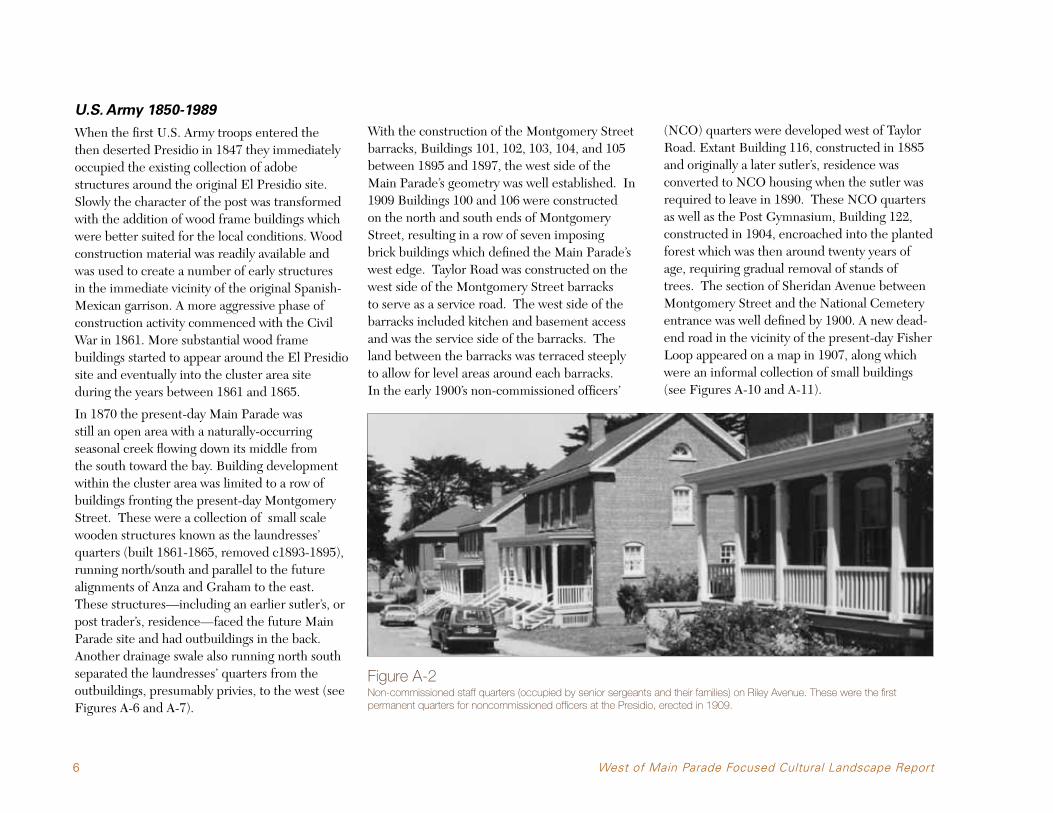
With the construction of the Montgomery Street barracks, Buildings 101, 102, 103, 104, and 105 between 1895 and 1897, the west side of the Main Parade’s geometry was well established. In 1909 Buildings 100 and 106 were constructed on the north and south ends of Montgomery Street, resulting in a row of seven imposing brick buildings which defined the Main Parade’s west edge. Taylor Road was constructed on the west side of the Montgomery Street barracks to serve as a service road. The west side of the barracks included kitchen and basement access and was the service side of the barracks. The land between the barracks was terraced steeply to allow for level areas around each barracks. In the early 1900’s non-commissioned officers’
(NCO) quarters were developed west of Taylor Road. Extant Building 116, constructed in 1885 and originally a later sutler’s, residence was converted to NCO housing when the sutler was required to leave in 1890. These NCO quarters as well as the Post Gymnasium, Building 122, constructed in 1904, encroached into the planted forest which was then around twenty years of age, requiring gradual removal of stands of trees. The section of Sheridan Avenue between Montgomery Street and the National Cemetery entrance was well defined by 1900. A new dead- end road in the vicinity of the present-day Fisher Loop appeared on a map in 1907, along which were an informal collection of small buildings (see Figures A-10 and A-11).
Figure A-2Non-commissioned staff quarters (occupied by senior sergeants and their families) on Riley Avenue. These were the first permanent quarters for noncommissioned officers at the Presidio, erected in 1909.

7
Sometime around 1915 the section of Lincoln Boulevard between Building 106 and the National Cemetery entry was constructed (see Figure A-12). Riley Avenue was extended past the front of Building 122 connecting Sheridan with the new segment of Lincoln. Three NCO quarters were built on the east side of Riley Avenue (extant Buildings 124, 125, and 126) in 1909. A small electrical switching station building, Building 107, was built on the north end of Taylor. The number of small buildings in the vicinity of the future Fisher Loop increased and in the 1928 map this area is labeled as “Igorote Village”1 (see Figures A-14 and A-15).
The construction of the Presidio Chapel, Building 130 and Fisher Loop in 1931 had a huge impact on the area between the road named Infantry Terrace and the National Cemetery. Extensive grading was required to create both the building pad and the roadway itself. The resulting change in grade resulted in the removal of a portion of the historic forest plantings. Fisher Loop connected the chapel with Infantry Terrace2 and several years later, a new gate was added into the National Cemetery, presumably to provide access between the chapel and the cemetery. While the number of residential buildings between Taylor Road and Ord Street remained at four, there was extensive
development of garage and storage structures along Taylor Road behind Buildings 103, 104, and 105 and along the short connecting road, Miles Street, running between Taylor Road and Ord Street, including the existing garage Building 123. The final three NCO quarters were built onRileyin1931—Buildings127,128,and129.Another storage building (Building 117) on Taylor was built west of Building 100 sometime before 1934 (see Figures A-14 and A-15).
By 1941 the roadways in the cluster area were complete with the addition of Bliss Road south of Building 100, creating the southern terminus for Taylor Road. Work completed in 1940, just before the onset of World War II, included a number of small-scale structures: Building 108, a storage and electric shop was build on the north end of Taylor Road, and garage structures 113 and 118 were added on Taylor Road and Ord Street, respectively. Building 113 replaced one of the NCO quarters from the early 20th century. The non-extant Building 112 also built in 1940 on Taylor Road, west of Building 102, was a machine gun shop (see Figures A-19).
In the 1948 aerial photograph (Figure A-20), Building 135, the Golden Gate Club, is shown under construction. With its completion the cluster area’s building ensemble was complete. The three buildings within the site demolished after the end of the period of significance were all located along Taylor Road or Ord Street and contribute to that area’s diminished integrity. Figure A-3
Building 135, formerly known as the Enlisted Men’s Service Club, under construction, c1949.
1 An Igorote is a member of several related mountain tribes of Luzon Islands in the Philippines. It is not known why these buildings are so referenced.2 Infantry Terrace is both the name of a Presidio neighborhood and a road. In this report any reference to Infantry Terrace will be the road, unless noted otherwise.
Part 1: Site History, Existing Conditions, Analysis & Evaluation

8 West of Main Parade Focused Cultural Landscape Report
Post U.S. Army
After the transition of the area’s management to the National Park Service in 1994, a few building rehabilitation projects affected the cluster area. Many of them were the result of the need to provide universal access into buildings, so involved the construction of curb-cuts, accessible ramps and parking spaces, and accessible routes of travel into buildings. In 1995, the NPS rehabilitated the Golden Gate Club, which resulted in changes to the landscape around the building. Foundation plantings were replaced, and the iceplant ground-cover north and east of the building was replaced with irrigated lawn. The front courtyard was replanted and modifications were made to the walkways to provide an accessible entrance to the courtyard. In 1996, Building 116 was rehabilitated for office use, and minor landscape changes were implemented, such as the construction of an accessible ramp on the east side of the building and the installation of a sand volley ball court in a former lawn area.3 After the Presidio Trust was established in 1996 and given administrative authority over the inland portion of the Presidio (known as Area B), several building rehabilitation projects were completed. The most extensive of these was the Walt Disney Family Museum (WDFM) rehabilitation of Buildings 104, 108, and 122, and the landscape surrounding all three buildings, completed in 2009. Building 104’s rear courtyard was filled in with a two-story structure clad in glass. The existing parking lot
Figure A-4Existing parking lot directly west of Building 104 includes landscaping, permeable unit pavers, bioswales and new site lighting.
directly west of Building 104, west of Taylor Road, was formalized and landscaped as part of this project, adding a planted strip on either side of a new east/west sidewalk that connected to Building 122. It also repaved the parking lot and added sections of unit pavers instead of asphalt to improve permeability. Stone filled bioswales were incorporated into this parking lot, along with new site lighting on Taylor Road and between
Taylor and Montgomery Street. The area north of Building 122 where some mature Monterey Cypress stand, was supplemented with new cypress trees to help re-establish the character of the historic forest formerly located here. The site immediately surrounding Building 122 was also replanted with new foundation plantings. In c.2000, a commemorative tree was planted west of the Riley Avenue residences to honor the
3 The last Army-era use was also as offices.

9
Costanoan Rumsen Carmel Tribe in the location of a lost historic tree. Rehabilitation of Building 100 began in 2010, also involving the infilling of its rear courtyard. This new structure will be a one-story addition with a glazed exterior. The landscape to the west and south of Building
100 will be altered with the addition of a new landscaped area that creates a small garden partially concealed from Taylor Road by walls and hedges. Rehabilitation of Buildings 101, 102 and 103 began in 2010, including landscape improvement to the rear couryards of Buildings
101 and 103. Also in 2010, the Trust completed a district-wide planning update (the Main Post Update) which calls for the formalization/construction of a 182-stall parking lot along Taylor Road between Infantry Terrace and Lincoln Boulevard, and an addition to the west side of the Presidio Chapel.
Post 1994 Building and Landscape Projects in West of Main Parade Cluster
BUILDING NUMBER
BUILDING NAME DATE OF REHAB
DESCRIPTION OF WORK
135 Golden Gate Club 1995 Rehabilitation of building and landscape
116 Former sutler’s residence
1996 Rehabilitation of building and partial landscapeupgrade
106 Band barracks 1996 Rehabilitation of building and landscape
104 Barracks 2009 Rehabilitation of buidling with new two storystructure infilling courtyard. Rehabilitation ofsurrounding landscape
108 Storage building 2009 Rehabilitation of building
122 Gymnasium 2009 Rehabilitation of building and landscape. Removal of non-historic addition on south side
n/a Northern Taylor Road parking lot
2009 Repaving of lot, adding trees and streetlights
100 Band barracks 2011 Rehabilitation of building and landscape/newone-story structure in courtyard
101 Barracks 2011 Rehabiltiation of exterior and partial interior,with total landscape rehabilitation
103 Barracks 2011 Rehabilitation of exterior and partial interior,with total landscape rehabilitation
Table 1Post 1994 building and landscape projects in West of Main Parade cluster area.
Figure A-5Building 116 was rehabilitated in 1996.
Part 1: Site History, Existing Conditions, Analysis & Evaluation

10 West of Main Parade Focused Cultural Landscape Report
A.3 Historic Period Maps
Figure A-6: 1870 MapFrom the Map of the Military Reservation at the Presidio of San Francisco California. Originally set aside by order of the President November 6th, 1850 and modified December 31, 1851. Surveyed by and under the direction of Lieut. CEO. M. Wheeler, 1870.
Park Archives Collections, Golden Gate National Recreation Area, National Park Service, R.G. #77 DR 93, sheet 4-#17.
11
Figure A-7: 1880 MapFrom the Plan of Post of Presidio. Surveyed under the direction ofCapt. W.A. Jones, May 1880. Photo by H.H. Price Topo. Assist.
Part 1: Site History, Existing Conditions, Analysis & Evaluation

12 West of Main Parade Focused Cultural Landscape Report
Figure A-8: 1900 MapFrom Map of the Military Reservation of the Presidio of San Francisco, California. Surveyed under the direction of Lt. Col. James M. Marshall by Red J.H. Rickon, CE., and drafted by C. Winstanley, August 1900.
U.S. Army 1900.

13
Figure A-9: 1902 MapFrom Map of the Military Reservation of the Presidio of San Francisco, California - Showing Present Timber Area and Proposed Plantations (Based on the Official Map of 1900), Hall 1902.
Part 1: Site History, Existing Conditions, Analysis & Evaluation

14 West of Main Parade Focused Cultural Landscape Report
Figure A-10: 1904 MapFrom Military Posts in US & Alaska, 1904.

15
Figure A-11: 1907 MapFrom the Report of Major Harts Plates 7 and 8.
Park Archives Collections, Golden Gate National Recreation Area, National Park Service, R.G. #92 Blueprint Files Presidio 59-8.
Part 1: Site History, Existing Conditions, Analysis & Evaluation

16 West of Main Parade Focused Cultural Landscape Report
Figure A-12: 1915 MapFrom the Map of the Presidio of San Francisco, Cal. Drawin in Office of the Constructing Quartermaster, San Francisco. Map of Major WmW. Harts Corps of Engineers, U.S.A. Chief engineer Pacific Division, Dated February 1907. and from Surveys Made by Office of the Constructing Quartermaster May 1910. Corrected Jan. 1915.
PSFNHL 1917.
17
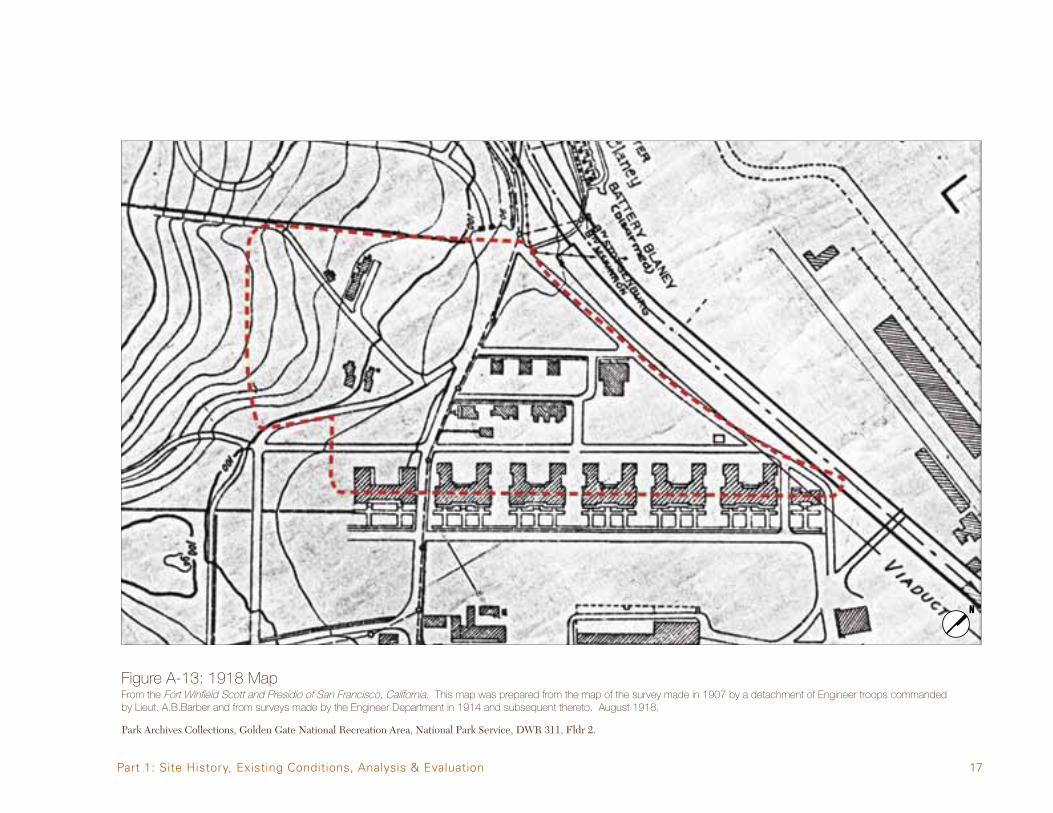
Figure A-13: 1918 MapFrom the Fort Winfield Scott and Presidio of San Francisco, California. This map was prepared from the map of the survey made in 1907 by a detachment of Engineer troops commanded by Lieut. A.B.Barber and from surveys made by the Engineer Department in 1914 and subsequent thereto. August 1918.
Park Archives Collections, Golden Gate National Recreation Area, National Park Service, DWR 311, Fldr 2.
Part 1: Site History, Existing Conditions, Analysis & Evaluation

18 West of Main Parade Focused Cultural Landscape Report
Figure A-14: 1927 AerialFrom the Aerial Photographic Mosaic Map of Presidio of San Francisco, California. Photographed and assembled by 15th Photo Section, Air Corps. Sept. 7, 1927.

19
Figure A-15: 1928 Map
Park Archives Collections, Golden Gate National Recreation Area, National Park Service.
Part 1: Site History, Existing Conditions, Analysis & Evaluation

20 West of Main Parade Focused Cultural Landscape Report
Figure A-16: 1934 MapFrom the Presidio of San Francisco and Fort Winfield Scott. Prepared from a survey map made in 1907 by a detachment of Engineer Troops, from Surveys made by the Engr. Dept. in 1914 and later. And from other available data. HQ9th Corps Area, July 1934.
Park Archives Collections, Golden Gate National Recreation Area, National Park Service.
21
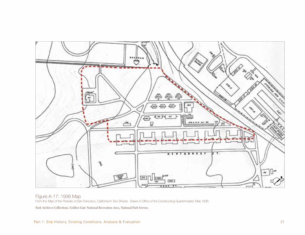
Figure A-17: 1936 MapFrom the Map of the Presidio of San Francisco, California In Two Sheets. Drawn in Office of the Constructing Quartermaster, May 1936.
Park Archives Collections, Golden Gate National Recreation Area, National Park Service.
Part 1: Site History, Existing Conditions, Analysis & Evaluation

22 West of Main Parade Focused Cultural Landscape Report
Figure A-18: 1937 Aerial
Pacific Aerial Surveys, Negative # AV-248-02-05, 1937.

23
Figure A-19: 1943 MapFrom the Fort Winfield Scott and Presidio of San Francisco California Map, 1942. Revised 1943.
Park Archives Collections, Golden Gate National Recreation Area, National Park Service.
Part 1: Site History, Existing Conditions, Analysis & Evaluation

24 West of Main Parade Focused Cultural Landscape Report
Figure A-20: 1948 Aerial
Pacific Aerial Surveys, Negative # AV-17-6-2, July 28, 1948.

25
Figure A-21: 1955 Aerial
Pacific Aerial Surveys, Negative # AV-170-04-02, May 10, 1955.
Part 1: Site History, Existing Conditions, Analysis & Evaluation

26 West of Main Parade Focused Cultural Landscape Report
Figure A-22: 2010 Map

27
A.4 Historic Photographs
Figure A-23: 1928 Bird’s Eye View Aerial
Presidio Army Museum Photo Collection, GGNRA, NPS; GGNRA Park Archives; PAM prints, Box 2, F. 40; GOGA-1766; 1/19/28.
Part 1: Site History, Existing Conditions, Analysis & Evaluation

28 West of Main Parade Focused Cultural Landscape Report
Figure A-24: Bird’s Eye View Aerial, c. 1958
Presidio Army Museum Photo Collection; GOGA-1766.0001; PAM Neg Box 1; No date.
29
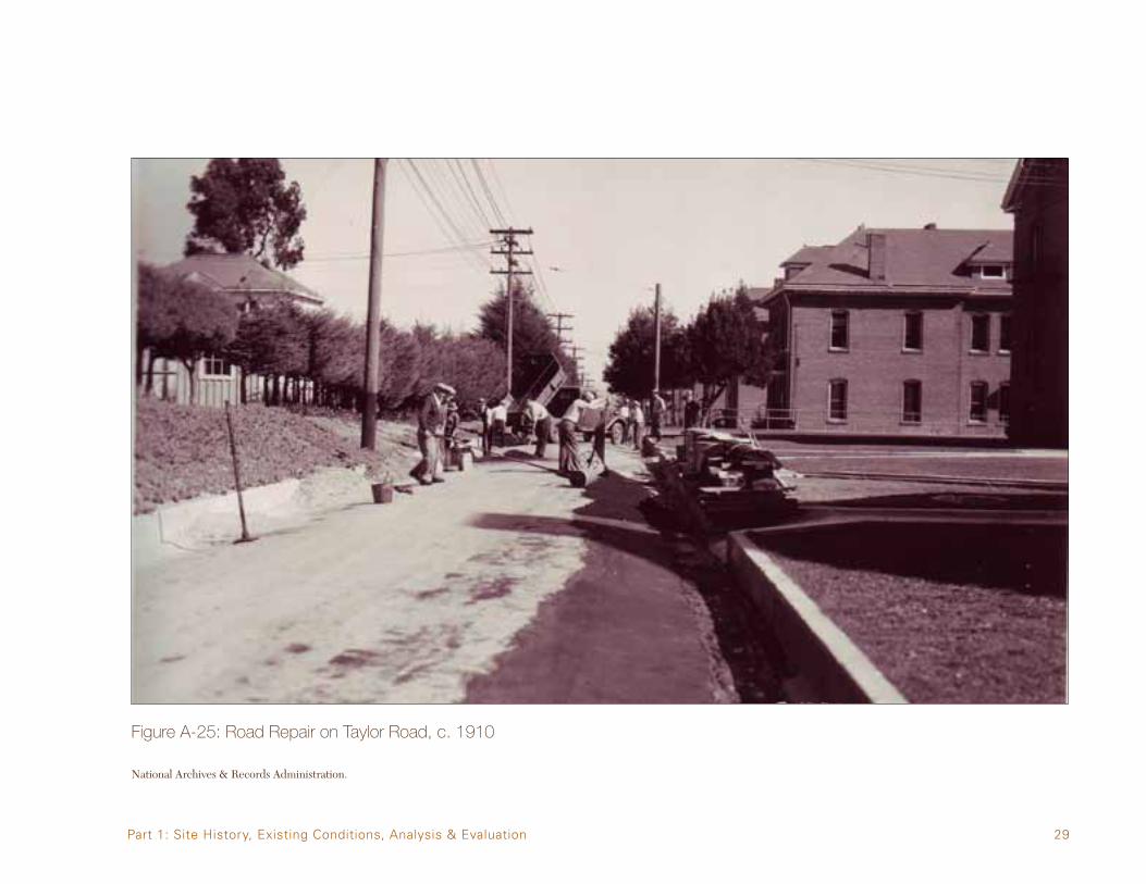
Figure A-25: Road Repair on Taylor Road, c. 1910
National Archives & Records Administration.
Part 1: Site History, Existing Conditions, Analysis & Evaluation

30 West of Main Parade Focused Cultural Landscape Report
Figure A-26: Riley Avenue Buildings, c. 1910
GGNRA Park Archives; Office of the Regional Historian, NPS; Defender of the Gate (GOGA-2991.201, Ch.15).

31
Figure A-27: Post Gymnasium (Building 122)
Presidio Museum Collection, 1915.
Part 1: Site History, Existing Conditions, Analysis & Evaluation
32 West of Main Parade Focused Cultural Landscape Report
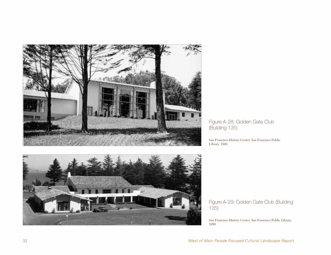
Figure A-28: Golden Gate Club (Building 135)
San Francisco History Center, San Francisco Public Library, 1949.
Figure A-29: Golden Gate Club (Building 135)
San Francisco History Center, San Francisco Public Library, 1950.

33
Figure A-30: Golden Gate Club Entrance
San Francisco History Center, San Francisco Public Library. Negative #8827 September 2, 1951.
Part 1: Site History, Existing Conditions, Analysis & Evaluation

34 West of Main Parade Focused Cultural Landscape Report
Figure A-31: Post Chapel and Grounds (Building 130)
San Francisco History Center, San Francisco Public Library, 1940.

35
B. EXISTING CONDITIONS
B.1 Physical SettingThe subject of this document is a 14.7 acre site in the western portion of the Presidio of San Francisco’s Main Post called the West of Main Parade cluster area. It is located within the boundaries of the Presidio of San Francisco on the edge of the San Francisco Bay just inside the Golden Gate. The Presidio of San Francisco is a former military post now administered by the
Presidio Trust, and it is part of the Golden Gate National Recreation Area, a unit of the National Park Service. Geologically, the site is made from Pleistocene and recent marine sands, sandstone and alluvium. The site begins on the north at the edge of the bluff and extends uphill to the ridge on the south. Before European contact the site vegetation was coastal prairie and coastal scrub on the lower elevations and dune scrub on the
higher elevations on the ridge. The entire site’s vegetation as well as most of the surrounding areas has been heavily altered, except for the bluff to the north of the cluster areas facing the bay that may have a small amount of remnant native vegetation. The cluster area was developed by the US Army starting around 1870 initially on the eastern edge with development spreading to the west and covering most of the site by 1950. The existing vegetation includes remnants of the historic forest on the western edge, including both stands of Eucalyptus and Monterey Cypress. Planted amongst the buildings are a wide assortment of ornamental trees and shrubs that over recent years have thinned out due to natural loss and removal without the benefit of any major replanting.
Figure AAerial view of the Main Post with the City of San Francisco in the backdrop.
Parade cluster area.
WEST OF MAIN PARADE
MAIN PARADE
COMMUNITYDISTRICT
OLD PARADE
FUNSTON AVENUE
HALLECK STREET
MAIN POST BLUFF
EL PRESIDIO
INFANTRY TERRACE
Figure B-1The West of Main Parade cluster area is a 14.7-acre site on the western portion of the Main Post.
Figure B-2Remnants of historic forest on the western edge.
Part 1: Site History, Existing Conditions, Analysis & Evaluation

36 West of Main Parade Focused Cultural Landscape Report
B.2 Access and CirculationGeneral Access
Because the Presidio is located within the city of San Francisco, it has multiple access points from the surrounding neighborhoods. From the south there are entries at the 25th Avenue Gate, the 14th Avenue Gate, the Arguello Gate and the Presidio Gate. Recent work at the Public Health Service District has reopened 14th Avenue as an entry only and converted 15th Avenue as an exit only. Both the Arguello and Presidio gates are on city streets that have the same name as the corresponding gates. From the shorter eastern boundary east there are just four entrances: Lombard Gate, Gorgas Gate, Marina Gate, and the recently added slip ramp off Doyle Drive,4 the approach to the Golden Gate Bridge. With the northern edge of the Presidio on the shores of the San Francisco Bay and the western edge on the Pacific Ocean the only entrance from these two directions is on the Merchant Road exit just south of the Golden Gate Bridge. Presently Highway 101 passes through the park connecting the Golden Gate Bridge with the city at Richardson Avenue. Highway 1 also passes through the park connecting the bridge with Park Presidio. Presently there are no direct connections from Highway 101 or 1 into the park except at Merchant Road. However the current Doyle Drive project will add a new interchange entrance at Gorgas Avenue in the Letterman Hospital District, just east of the Main Post.
Pedestrians and bicyclists can use all of the previously mentioned entrances except for Gorgas slip ramp and the future Gorgas Avenue interchange. Additional points of pedestrian and bicycle entry include. Mountain Lake Park, Julius Kahn Playground, the Broadway Gate, and the pedestrian only Chestnut Gate at the Letterman Digital Arts campus.
The Presidio’s surface roads that provide access into the West of Main Parade cluster area include
Infantry Terrace, Bliss Road, Sheridan Avenue, and Lincoln Boulevard, from both the east and the west. The larger roads that pass through the site are Infantry Terrace, Sheridan Avenue, and Lincoln Boulevard. Streets wholly internal to the site include Taylor Road, Fisher Loop, Ord Street, Riley Avenue, and Miles Street (a one hundred foot-long connection between Taylor Road and Ord Street). All of the roads into and within the West of Main Parade cluster area are paved in asphalt.
Figure B-3Access points, major routes and interal roads in the West of Main Parade cluster area.
Access Points
Major Roads
Internal Roads
West of Main Parade Cluster Area
4 Broadway and Greenwich Gates on the eastern boundary are closed and no longer serviced by roadways into the Presidio.

37
Access Points
Major Roads
Internal Roads
West of Main Parade Cluster Area
Parking Areas
Paved parking areas are found west of both the Presidio Chapel (Building 130) and the Golden Gate Club (Building 135). A recently improved parking area (completed 2009) between Buildings 122 and 104 includes both asphalt paving and permeable pavers. Presently all large open areas between Taylor Road and Ord Street are temporarily paved in gravel and serve as both a construction lay-down area and informal parking. The only streets within the cluster area that curently provides on-street parking are Riley Avenue and Bliss Road.
Trails
No formalized or improved trails yet exist in the area, however the Presidio Trails and Bikeways Master Plan calls for a multi-use trail along Lincoln Boulevard on the northern edge of the cluster area, and a pedestrian trail connection down the ridge from the historic forest to the back of the Presidio Chapel. The multi-use trail along Lincoln Boulevard is a segment of the Presidio Promenade and will be constructed as part of the Doyle Drive improvements. The pedestrian trail above the Presidio Chapel is currently an unapproved social trail that is being redesigned as an accessible connector between the chapel area and the East Washington neighborhood. Called the Cemetery Connector Trail, this work has not yet been funded or scheduled.
Part 1: Site History, Existing Conditions, Analysis & Evaluation
Figure B-4Recently improved parking area between behind Building 103 which includes both asphalt paving and permeable pavers.

38 West of Main Parade Focused Cultural Landscape Report
B.3 Land UseThe entire West of Main Parade cluster area is administered by the Presidio Trust. While all military use of the area has ceased, the land use of the residential units along Riley Avenue, the Golden Gate Club, and the Presidio Chapel remain similar to their use during the period of significance (1776 to 1945, and 1951). Buildings 104, 108, and 122 are leased by the Walt Disney Family Museum and the current tenant of Building 116 is a private architectural practice. Building 100 is currently undergoing rehabilitation to serve as the future headquarters for the Family Violence Prevention Fund. Buildings 101 and 103 are undergoing rehabilitation as well, but with no tenant identified at this time. Building 102 remains under control of the National Park Service and is currently undergoing seismic upgrades. Building 105 is unoccupied and scheduled for rehabilitation by 2015.
B.4 VegetationThe original dune coastal scrub plantings have long since disappeared within the cluster area. The first major planting effort for the site was the historic forest planting of the 1880’s which covered approximately half of the site on its west side. Building development in the early twentieth century encroached into the forest resulting in gradual tree removal. Extensive tree removal associated with the construction of Fisher Loop and Presidio Chapel continued in the early 1930’s. The greatest number of small-scale ornamental plantings exists around the residential units on Riley Avenue and around the Presidio Chapel. The recent work at the WDFM resulted in new foundation plantings at 104 and 122 and new tree planting in the parking lot between the two buildings. Today the site is a mix of remnants of the historic forest, small scale ornamental plantings, limited areas of irrigated lawn and scattered open spaces with seasonal European perennial grasses.
B.5 Archaeological ResourcesLocated near the back of Buildings 104 and 105 is an area that that was described as a “Spanish and Indian Cemetery” by the US Army in some of their earliest maps. It is unknown what was done to the cemetery in advance of the construction of both Buildings 104 and 105.
B.6 Building and StructuresThere are fifteen free-standing buildings within the cluster area that are listed as contributing resources to the Presidio NHL. The only other free-standing structures, not listed as contributing, are the three storage sheds west of Ord Street behind the Riley residential units (Buildings 119, 120, and 121 built c1970).
Figure B-5Rehabilitated Building 104 currently leased by the Walt Disney Family Museum.
Figure B-6Storage sheds behind Riley residential units.
39
C. ANALYSIS & EVALUATION
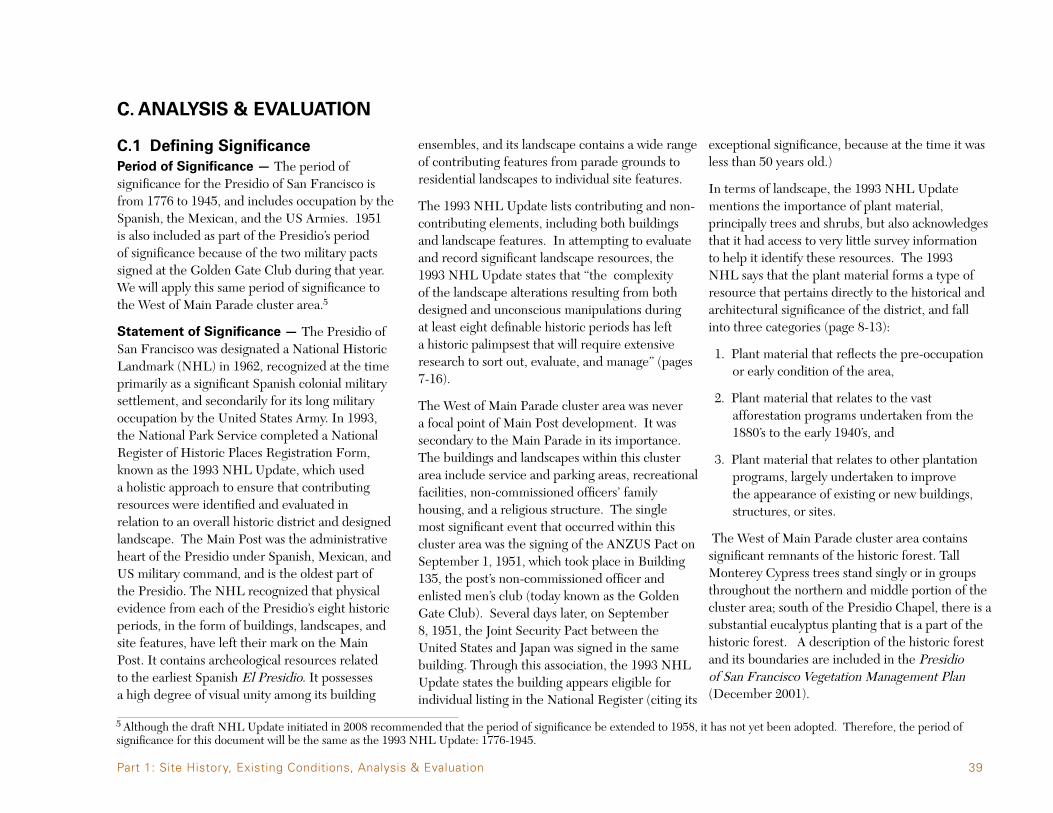
C.1 Defining SignificancePeriod of Significance — The period of significance for the Presidio of San Francisco is from 1776 to 1945, and includes occupation by the Spanish, the Mexican, and the US Armies. 1951 is also included as part of the Presidio’s period of significance because of the two military pacts signed at the Golden Gate Club during that year. We will apply this same period of significance to the West of Main Parade cluster area.5
Statement of Significance — The Presidio of San Francisco was designated a National Historic Landmark (NHL) in 1962, recognized at the time primarily as a significant Spanish colonial military settlement, and secondarily for its long military occupation by the United States Army. In 1993, the National Park Service completed a National Register of Historic Places Registration Form, known as the 1993 NHL Update, which used a holistic approach to ensure that contributing resources were identified and evaluated in relation to an overall historic district and designed landscape. The Main Post was the administrative heart of the Presidio under Spanish, Mexican, and US military command, and is the oldest part of the Presidio. The NHL recognized that physical evidence from each of the Presidio’s eight historic periods, in the form of buildings, landscapes, and site features, have left their mark on the Main Post. It contains archeological resources related to the earliest Spanish El Presidio. It possesses a high degree of visual unity among its building
ensembles, and its landscape contains a wide range of contributing features from parade grounds to residential landscapes to individual site features.
The 1993 NHL Update lists contributing and non-contributing elements, including both buildings and landscape features. In attempting to evaluate and record significant landscape resources, the 1993 NHL Update states that “the complexity of the landscape alterations resulting from both designed and unconscious manipulations during at least eight definable historic periods has left a historic palimpsest that will require extensive research to sort out, evaluate, and manage” (pages 7-16).
The West of Main Parade cluster area was never a focal point of Main Post development. It was secondary to the Main Parade in its importance. The buildings and landscapes within this cluster area include service and parking areas, recreational facilities, non-commissioned officers’ family housing, and a religious structure. The single most significant event that occurred within this cluster area was the signing of the ANZUS Pact on September 1, 1951, which took place in Building 135, the post’s non-commissioned officer and enlisted men’s club (today known as the Golden Gate Club). Several days later, on September 8, 1951, the Joint Security Pact between the United States and Japan was signed in the same building. Through this association, the 1993 NHL Update states the building appears eligible for individual listing in the National Register (citing its
exceptional significance, because at the time it was less than 50 years old.)
In terms of landscape, the 1993 NHL Update mentions the importance of plant material, principally trees and shrubs, but also acknowledges that it had access to very little survey information to help it identify these resources. The 1993 NHL says that the plant material forms a type of resource that pertains directly to the historical and architectural significance of the district, and fall into three categories (page 8-13):
1. Plant material that reflects the pre-occupation or early condition of the area,
2. Plant material that relates to the vast afforestation programs undertaken from the 1880’s to the early 1940’s, and
3. Plant material that relates to other plantation programs, largely undertaken to improve the appearance of existing or new buildings, structures, or sites.
The West of Main Parade cluster area contains significant remnants of the historic forest. Tall Monterey Cypress trees stand singly or in groups throughout the northern and middle portion of the cluster area; south of the Presidio Chapel, there is a substantial eucalyptus planting that is a part of the historic forest. A description of the historic forest and its boundaries are included in the Presidio of San Francisco Vegetation Management Plan (December 2001).
5 Although the draft NHL Update initiated in 2008 recommended that the period of significance be extended to 1958, it has not yet been adopted. Therefore, the period of significance for this document will be the same as the 1993 NHL Update: 1776-1945.
Part 1: Site History, Existing Conditions, Analysis & Evaluation

40 West of Main Parade Focused Cultural Landscape Report
No. FEATURE FEATURE TYPE DATE OF ORIGIN NOTES FROM PERIOD OF SIGNIFICANCE
W E S T O F M A I N P A R A D E — C O N T R I B U T I N G F E A T U R E S Building 100 - Montgomery Street Barrack Buildings 1909 Yes Building 101 - Montgomery Street Barrack Buildings 1895 Yes Building 102 - Montgomery Street Barrack Buildings 1896 Yes Building 103 - Montgomery Street Barrack Buildings 1896 Yes Building 104 - Montgomery Street Barrack Buildings 1897 Yes Building 105 - Montgomery Street Barrack Buildings 1897 Yes Building 106 - Montgomery Street Barrack Buildings 1909 YesF.1 Building 107 - Switching Station Buildings 1911 YesF.2 Building 108 - Storage Buildings 1940 YesF.3 Building 113 - Garage Buildings 1940 YesF.4 Building 116 - Post Trader Buildings 1885 YesF.5 Building 118 - Garage Buildings 1940 YesF.6 Building 122 - Gymnasium Buildings 1904 YesF.7 Building 123 - Garage Buildings 1930 YesF.8 Building 124 - Enlisted Family Quarters Buildings 1909 YesF.9 Building 125 - Enlisted Family Quarters Buildings 1909 YesF.10 Building 126 - Enlisted Family Quarters Buildings 1909 YesF.11 Building 127 - Enlisted Family Quarters Buildings 1931 YesF.12 Building 128 - Enlisted Family Quarters Buildings 1931 YesF.13 Building 129 - Enlisted Family Quarters Buildings 1931 YesF.14 Building 130 - Chapel Buildings 1932 YesF.15 Building 135 - Service Club Buildings 1949 Currently Golden Gate Club YesF.16 Fisher Loop Circulation 1912 YesF.17 Riley Avenue Circulation 1912 YesF.18 Ord Street Circulation 1912 YesF.23 Taylor Road Circulation 1895 YesF.25 Plaque honoring Charles B. Stone, Jr. Small Scale Features 1936 Yes C.O. Presidio 1930-33F.32 Drip-line concrete swale Small Scale Features 1949 Associated with B. 135 Yes, by association with B. 135F.33 Drainage head wall Small Scale Features Unknown LikelyF.35 Concrete driveway curb-cut Small Scale Features Unknown Associated with B. 117 LikelyF.37 Concrete drainage swales Small Scale Features Unkown Several along Riley LikelyF.38 Metal boot scaper in porch stoop Small Scale Features Unknown Three along Riley YesF.39 Concrete apron to B. 123 Small Scale Features Unknown LikelyF.40 Concrete apron to B. 113 Small Scale Features Unknown LikelyF.41 Masonry and concrete drainage swale Small Scale Features Unknown West side of Ord LikelyF.42 Masonry and concrete drainage swale Small Scale Features Unknown East side of Ord LikelyF.44 Concrete wall Small Scale Features Unknown LikelyF.45 Manhole cover Small Scale Features Unknown LikelyF.46 Garbage can pad Small Scale Features Unknown Likely
N O N - C O N T R I B U T I N G R E S O U R C E S Building 119 - Detached storage building Secondary Structure c. 1970 Building 120 - Detached storage building Secondary Structure c. 1970 Building 121 - Detached storage building Secondary Structure c. 1970 Miles Street Circulation Unknown F.19 Surface Parking Lot Circulation Unknown NoF.20 Surface Parking Lot Circulation c. 2007 NoF.21 Surface Parking Lot Circulation c. 1960’s NoF.22 Surface Parking Lot Circulation c. 1930’s Expanded in the 1960’s NoF.24 Stucco Sign Small Scale Features c. 1970’s NoF.26 Post Chapel Sign Small Scale Features Unknown UnknownF.27 Memorial Garden Small Scale Features 1975 NoF.28 Viet Nam Memorial Small Scale Features Unknown NoF.29 US Army Chaplins Memorial Small Scale Features 1973 NoF.30 Stairs and cheek walls Small Scale Features c. 1965 NoF.31 D-Day Memorial Small Scale Features 1984 NoF.34 Cast stone lamp post Small Scale Features c. 1960’s Several in district UnlikelyF.36 Metal pipe railings Small Scale Features Unknown UnlikelyF.43 Metal pipe railings Small Scale Features Unknown Unlikely
Table 2This table serves as a reference for the C.2 Analysis and C.3 Assessing Historical Integrity sections.

41
Figure C-1Map of West of Main Parade cluster area showing building and circulation features. Locations of small scale features are shown in section C.3 (pages 73-88).
Part 1: Site History, Existing Conditions, Analysis & Evaluation
42 West of Main Parade Focused Cultural Landscape Report
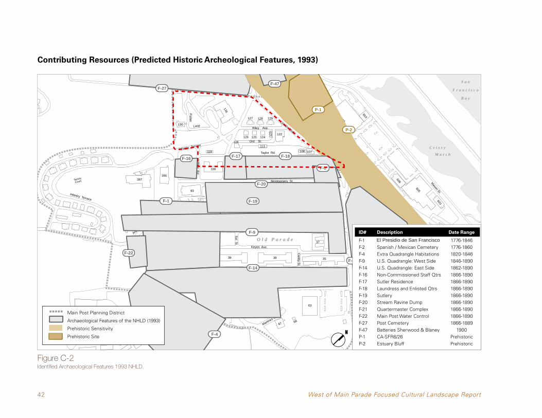
Contributing Resources (Predicted Historic Archeological Features, 1993)
S a n
F r a n c i s c o
B a y
C r i s s y
M a r s h
39
386
12
97
1516 14 13 1011
116
130
99
135
128127 129
107108
3
38
9 8 7 6 5
37
86 87
4
35
6867
210
36
218
205
223
222224
227228
229
610
653
603
605
606
Infantry Terrace
Martinez St.
Moraga S
t.
Arguell
o Blvd
.
Infantry Terrace
Wallen
Quarry Rd
Funston Ave.Hardie Ave.
Pena S
t.
Presidio B
lvd. Girard Rd.
Ord St.
Riley Ave.
Fisher
Loop
Bliss R
d.
Lincoln Blvd.
Mesa St.
Sheridan Ave.
Taylor Rd.
Montgomery St.
Anza St.
Sal S
t.
Graham St.
Keyes Ave.
Ow
en St.
Canby S
t.
Lincoln Blvd.
Halleck St.
Mason St.
Gor
gas
Ave
.
Thornburg Rd
Edie Rd.
Doyle Drive / Highway 101
123
215
93
204126 125 124
122
201
41 40
34
211
231
230
118
113
98TennisCourt
MacArth
ur
Portola
MacArthur
O l d P a r a d e
M a i n P a r a d e
2
TennisCourt
51 56
57 58
5964
65
63
44
47
48
50
49
45
42
220
225
95
385387
101100 102 NPS 103 104 105 106
Main Post Planning District
Archaeological Features of the NHLD (1993)
Prehistoric Sensitivity
Prehistoric Site
1 8 I D E N T I F I E D A R C H A E O L O G I C A L F E AT U R E S 1 9 9 3 N H L D
ID# Description Date Range
F-4
F-14
F-1
F-22
F-9
F-19
F-20
F-2
F-21
F-18F-17F-16
F-27F-47
P-1
P-2
400 FT0
Source: Presidio Trust 2010
Figure C-2Identified Archaeological Features 1993 NHLD.
Main Post Planning District
Archaeological Features of the NHLD (1993)
Prehistoric Sensitivity
Prehistoric Site
ID# Description Date Range
F-1 El Presidio de San Francisco 1776-1846F-2 Spanish / Mexican Cemetery 1776-1860F-4 Extra Quadrangle Habitations 1820-1846F-9 U.S. Quadrangle: West Side 1846-1890F-14 U.S. Quadrangle: East Side 1862-1890F-16 Non-Commissioned Staff Qtrs 1866-1890F-17 Sutler Residence 1866-1890F-18 Laundress and Enlisted Qtrs 1866-1890F-19 Sutlery 1866-1890F-20 Stream Ravine Dump 1866-1890F-21 Quartermaster Complex 1866-1890F-22 Main Post Water Control 1866-1890F-27 Post Cemetery 1866-1889F-47 Batteries Sherwood & Blaney 1900P-1 CA-SFR6/26 PrehistoricP-2 Estuary Bluff Prehistoric

43
Contributing Resources (Predicted Historic Archeological Features, 2008)
S a n
F r a n c i s c o
B a y
C r i s s y
M a r s h
39
386
12
97
1516 14 13 1011
116
130
99
135
128127 129
107108
3
38
9 8 7 6 5
37
86 87
4
35
6867
210
36
218
205
223
222224
227228
229
610
653
603
605
606
Infantry Terrace
Martinez St.
Moraga S
t.
Arguello Blvd.
Infantry Terrace
Wallen
Quarry Rd
Funston Ave.Hardie Ave.
Pena S
t.
Presidio B
lvd. Girard Rd.
Ord St.
Riley Ave.
Fisher
Loop
Bliss R
d.
Lincoln Blvd.
Mesa St.
Sheridan Ave.
Taylor Rd.
Montgomery St.
Anza St.
Sal S
t.
Graham St.
Keyes Ave.O
wen S
t.
Canby S
t.
Lincoln Blvd.
Halleck St.
Mason St.
Gor
gas
Ave
.
Thornburg Rd
Edie Rd.
Doyle Drive / Highway 101
123
215
93
204
126 125 124122
201
41 40
34
211
231
230
118
113
98TennisCourt
MacArth
ur
Portola
MacArthur
O l d P a r a d e
M a i n P a r a d e
2
TennisCourt
51 56
57 58
5964
65
63
44
47
48
50
49
45
42
220
225
95
385387
101100 102 NPS 103 104 105 106
Historic Structure Footprint
1 9 D R A F T I D E N T I F I E D A R C H A E O L O G I C A L F E AT U R E S 2 0 0 8 N H L D
F-4
F-14
F-1
F-22F-9F-9
F-19
F-27 F-47
F-20F-2 F-21
F-18
F-16
400 FT0
Source: Presidio Trust 2010
F-14
F-14
A-6F-14
Main Post Planning District
Archaeological Features of the NHLD (2008)
Prehistoric Sensitivity
Prehistoric Site
P-1P-2
A-18
Figure C-3Draft Identified Archaeological Features 2008 NHLD.
Main Post Planning District
Archaeological Features of the NHLD (2008)
Prehistoric Sensitivity
Prehistoric Site
Historic Structure Footprint
Part 1: Site History, Existing Conditions, Analysis & Evaluation
ID# Description Date Range
F-1 El Presidio de San Francisco 1776-1846F-2 Spanish / Mexican Cemetery 1776-1860F-4 Extra Quadrangle Habitations 1820-1846F-9 U.S. Quadrangle: West Side 1846-1890F-14 U.S. Quadrangle: East Side 1862-1890F-16 Non-Commissioned Staff Qtrs 1866-1890F-18 Laundress and Enlisted Qtrs 1866-1890F-19 Sutlery 1866-1890F-20 Stream Ravine Dump 1866-1890F-21 Quartermaster Complex 1866-1890F-22 Main Post Water Control 1866-1890F-27 Post Cemetery 1866-1889F-47 Batteries Sherwood & Blaney 1900P-1 CA-SFR6/26 PrehistoricP-2 Estuary Bluff PrehistoricA-6 Old Post Cemetery 1846-1860A-18 Quartermaster’s Dump 1866-1890

44 West of Main Parade Focused Cultural Landscape Report
C.2 AnalysisWhat follows is a description of the six topic areas below of the site through the period of significance up to present condition.
Topography & Natural Systems
The 14.7 acres of the West of Main Parade cluster area can be divided into two distinctive topographic zones that are close to equal in size. The first zone is the steeply sloped section west of the road called Infantry Terrace and south of Sheridan Avenue between its intersections with Infantry Terrace and Lincoln. The steeply sloped section starts at about 150 feet in elevation and slopes down to the northeast at an approximate 15% gradient. The steep slope then transitions into a sloping plane of approximately 5% gradient and continues to drop to the northeast and then terminates at the top of the coastal bluff that historically overlooked the marsh that now is Crissy Field. There was a defined swale just to the east of the site that was eventually culverted and placed beneath the Main Parade. A much smaller drainage swale within the cluster area can be seen on old maps just west of the laundresses’ quarters. It actually separated the quarters from their outbuildings to the west (see Figure A-7).
While the laundresses’ quarters very likely conformed to the existing sloping grade, the Montgomery Street Barracks which replaced them (Buildings 101, 102, 103, 104, and 105), along with their adjacent roads, Montgomery
Street and Taylor Road, resulted in major regrading of the site. The construction of Montgomery Street coincided with the filling of the swale to create the Main Parade. The smaller secondary drainage swale west of the barracks was either placed within a storm sewer or was carried in the gutters of Taylor Road. The sloping grade from north to south was divided up into terraces for each of the large barracks structures. While the slope directly in front of each building falls at a constant 4% the intermediate slopes between the building
terraces is a repeated grade of approximately 9% and is clearly visible from the Montgomery Street side of the buildings. These distinct slopes between the building terraces are not nearly as visible from the Taylor Road side.
To the west of Taylor Road the sloping plane was developed over time with several structures and two additional parallel roads, Ord Street and Riley Avenue. However none of those structures or roads required any significant grading and simply conformed to the existing grade. The
Figure C-4Gradual sloping grade from north to south along Montgomery Street. A drainage swale line the edge between Montgomery Street and the Main Parade.

45
result is that the building floor elevations drop from Sheridan Avenue toward the north at an even gradient without the distinct building terraces and connecting slopes found between the Montgomery Street barracks.
The cluster area’s greatest amount of topographical change occurred in three distinct phases within the steeply sloping section west of Infantry Terrace and south of Sheridan Avenue (the Presidio Chapel and Golden Gate Club area). The first phase of topographic change resulted from the construction of the Presidio Chapel (Building 130) in 1931, and the accompanying access road known as Fisher Loop. The building pad for the chapel was cut into the hillside on the uphill side and a small amount of fill was placed on the downhill side which likely resulted in a steepening of the grade along Fisher Loop at the approach to the chapel (see Figure C-5). The second phase of topographical change was associated with the construction of the Golden Gate Club starting in 1949 (see Figure A-21). The third and final phase of grading within this area was the result of the expansion of the parking lot west of the Presidio Chapel, and a new parking lot west of the Golden Gate Club. These parking lot improvements were done some time after 1955. The new parking lot west of the Golden Gate Club resulted in a steep, highly architectural slope that is crossed by a steep set of concrete stairs from the southwest corner of the building.
Figure C-5Steep slope around Fisher Loop.
Despite the major grading operations associated with the construction of the Presidio Chapel, the Golden Gate Club and their associated parking lots, the cluster area retains its two distinct topographic zones. These two zones include the steep slope around Fisher Loop and the gently sloping plane north of Sheridan Avenue. They are as readable in the landscape as they were at the end of the period of significance. The area’s original natural drainage systems were limited to the minor drainage swales within the
site and the major swale that was filled to create the Main Parade. Those open channels are no longer extant, because they were either diverted into culverts or lined swales or gutters as part of the urbanization of the area that occurred in the late nineteenth and early twentieth century. However, these modifications to the swales took place during the period of significance, and the resulting culverts and gutters are historic features which retain elements of their historic integrity.
Part 1: Site History, Existing Conditions, Analysis & Evaluation
46 West of Main Parade Focused Cultural Landscape Report
Documented Post-Contact Spatial Organization & Land Use
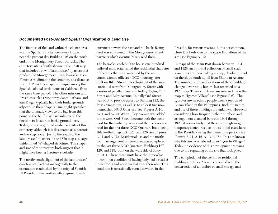
The first use of the land within the cluster area was the Spanish / Indian cemetery located near the present day Building 105 on the north end of the Montgomery Street Barracks. The cemetery site is faintly shown in the 1870 map that includes a row of laundresses’ quarters that predate the Montgomery Street barracks. (See Figure A-6) Situating the cemetery at a distance from El Presidio’s chapel is unique among the Spanish colonial settlements in California from the same time period. The other missions and Presidios such as Monterey, Santa Barbara, and San Diego, typically had their burial grounds adjacent to their chapels. One might speculate that the dramatic views to the bay from this point on the bluff may have influenced the decision to locate the burial ground here. Today, no above-ground evidence exists of this cemetery, although it is designated as a potential archaeology zone. Just to the south of the laundresses’ quarters in the 1870 map is a large unidentified “u”-shaped structure. The shape and size of the structure both suggest that it might have been a livestock stockade.
The north/ south alignment of the laundresses’ quarters was laid out orthogonally to the orientation established by the original Spanish El Presidio. This north/south alignment with
entrances toward the east and the backs facing west was continued in the Montgomery Street barracks which eventually replaced them.
The barracks, each built to house one hundred enlisted men, established the residential character of the area that was continued by the non-commissioned officers’ (NCO) housing later built on Riley Street. Development of the area continued west from Montgomery Street with a series of parallel streets including Taylor, Ord Street and Riley Avenue. Initially Ord Street was built to provide access to Building 122, the Post Gymnasium, as well as to at least two now-demolished NCO Quarters (see Figures A-10, A-11 and A-12). When Riley Avenue was added to the west, Ord Street became both the front road for the earlier quarters and the back service road for the first three NCO Quarters built facing Riley—Buildings124,125,and126(seeFiguresA-11 and A-12). Residential use and the north/south arrangement of structures was completed by the last three NCO Quarters, Buildings 127, 128, and 129, built on the west side of Riley in 1931. These three units have the somewhat uncommon condition of having only had a road at their fronts and no service alley at their rear. This condition is occasionally seen elsewhere in the
Presidio, for various reasons, but is not common. Here it is likely due to the space limitations of the site (see Figure A-16).
In maps of the Main Post drawn between 1904 and 1928, an informal collection of small-scale structures are shown along a steep, dead-end road on the slope south uphill from Sheridan Avenue. The number, size, and locations of these buildings changed over time, but are last recorded on a 1928 map. These structures are referred to on the map as “Igorote Village” (see Figure C-6). The Igorotes are an ethnic people from a section of Luzon Island in the Philippines. Both the nature and use of these buildings are unknown. However, considering how frequently their numbers and arrangement changed between 1904 through 1928, it seems likely that these were lightweight, temporary structures like others found elsewhere in the Presidio during that same time period (see Figures A-11, A-12, A-13, A-15). It is not known why this area was labeled as an “Igorote Village.” Today, no evidence of this development remains, due to the regrading of the site that took place.
The completion of the last three residential buildings on Riley Avenue coincided with the construction of a number of small storage and

47
parking structures between Ord Street and Taylor Road. Most of these structures were built north of Sheridan Avenue. The first phase of these buildings can be seen in Figure A-17 from 1936 while the full build-out can be seen in Figure A-19 from 1943.
West of Infantry Terrace (road) and south of Sheridan Avenue, the collection of small scale buildings labeled as “Igorote Village” were removed and replaced with the Presidio Chapel and the enhanced Fisher Loop in 1932. After its completion the Presidio Chapel was the only building in use in that area until the addition in 1949 of the Golden Gate Club. Both the chapel and the club had their parking lots expanded to the west sometime after 1955 (see Figure A-21 and A-22).
In summary, from the earliest days of the American period the cluster area served primarily as a place of residence, starting with the laundresses’ quarters, then the Montgomery Street barracks and finally the NCO Quarters on Riley Avenue. After housing, the next most common use for this area was for support services for both the immediate residents as well as those that resided elsewhere within the Presidio. Those buildings include: Building 116 (the sutler’s house), Building 122 (post
gymnasium), Building 130 (chapel) and Building 135 (NCO Club). The third category of building use is comprised of the various storage, parking, and utility structures located primarily between Taylor and Ord. Buildings and roadways were arranged in a north/south layout. This pattern persists today with high integrity. The spatial
arrangement of the area south of Sheridan Avenue does not follow this north/south pattern, but instead responds to the steepness of the slope, with buildings sitting on level pads. Fisher Loop forms a loose organizing framework for these two buildings, and retains high integrity.
Part 1: Site History, Existing Conditions, Analysis & Evaluation
Figure C-61928 map marking “Igorote Village.”

48 West of Main Parade Focused Cultural Landscape Report
Views and Vistas
Like many areas within the Presidio, the cluster area overlooks the San Francisco Bay with expansive views toward Alcatraz, Angel Island, and the Golden Gate Bridge to the west. Before the development of the streets and buildings of the American period and the planting of the historic forest, the most dramatic views out of the site would have been from the north edge of the bluff and on the slope near the Presidio Chapel. But with the planting and maturation of the forest and the development of Doyle Drive, those views were diminished. In addition to views of the bay, there are also framed views south toward the hill above the Main Post, and short range views of the Main Post in the east/west direction. Both Taylor Road and Riley Avenue have excellent views to the north of the San Francisco Bay, while Ord Street has a more restricted view because of Building 122 and the grove of Monterey Cypress trees along Lincoln. All threere roads have views to the rising hill to the south, though much less dramatic than the views toward the bay. As it runs west toward the National Cemetery, Sheridan Avenue has a view of the Marin Headlands while in the opposite direction it offers views centered on the backs of Buildings 100 and 101. With the high elevation
of the Presidio Chapel one can get both a wide angle and distant views filtered through the large trees. The only structure built within the site that may have been designed and situated to take advantage of the scenic views is Building 135, the Golden Gate Club. From the large ballroom
in the building an enormous window faces north toward the bay. However because the building site was carved out of the historic forest, the Monterey Cypress trees to the north and east of the building would have limited the views, much as they do today.
Figure C-71928 bird’s eye view aerial showing groves of trees on the western edge of the cluster area that diminish views to the bay from the Presidio Chapel.

49
Vegetation
At the time of the founding of El Presidio the vegetation on this site would have consisted of perennial grasses and other dune species on the uplands and large woody species such as oaks and willows limited to the low drainage swales where there would be both a supply of water and protection from the strong marine winds. During the Spanish and Mexican eras, it is unlikely that any significant planting occurred within the cluster area. That was also true for the laundresses’ quarters, which may have had some incidental ornamental plantings, none of which survives today. It wasn’t until the 1880’s when the forestation plan undertaken by the US Army under the direction of Major Jones transformed the cluster area by the planting of roughly half the site with large tree species. Based on the remaining trees we can see that the higher elevations on the slopes to the south were planted with Blue Gum (Eucalyptus globulus), and on the lower elevations of the hill and onto the sloping plane Monterey Cypress (Cupressus marocarpa) was planted. The original division line between these two species is not clear in the landscape and is unknown. It was likely to have been in the vicinity of Fisher Loop and was obscured during the construction of that roadway and the Presidio Chapel in the 1930’s (see Figures A-14, A-16, A-18).
The incidental and scattered ornamental plantings along Taylor Road, Ord Street and
Riley Avenue are not shown on any available drawing or plan and are best seen in the aerial photos and ground shots from the period of significance. In the 1937 aerial photo (see Figure A-18), with most of the buildings in place, one can see greenery on the west side of Taylor Road just north and south of Sheridan Avenue. Both of these plantings were a tightly spaced hedgerow of Monterey Cypress and can seen in Figure A-25, from the same time period as the aerial. The trees north of Sheridan Avenue are not trimmed while those to the south have been clipped into a shorter hedge, perhaps to screen the wood frame storage building on the opposite side (non-extant Building 117). Several of these
trees remain today however they are in poor structural condition as they were topped several times over the years.
In the 1948 aerial (Figure C-8) the tree groupings as well as some individual tree plantings can be seen. The back courtyards of the Montgomery Street barracks appear to be free of any significant trees or shrubs but have lawn planting which helps outline the pattern of concrete walkways. Between the barracks, Buildings 101, 102, 103, 104, and 105 thin lines of vegetation can be seen. These lines of vegetation are likely a hedge row of trees that were clipped like the row of trees west of
Figure C-81948 photograph aerial of the Montgomery Street Barracks’ courtyards and Taylor Road.
Part 1: Site History, Existing Conditions, Analysis & Evaluation

50 West of Main Parade Focused Cultural Landscape Report
Building 100 on the west side of Taylor Road seen both in the 1938 aerial and photo taken from the ground during the same period. Today in three of the locations between the barracks there exist single large tree (two cypress and one acacia), that are likely the only remaining trees from the original hedgerow plantings. The only other vegetation behind the barracks in 1948 was a clump of trees at the southwest corner of Building 101 at the intersection of Sheridan Avenue and Taylor Road.
Within the area between Taylor Road and Ord Street vegetation that can be seen in the 1948 aerial there are two Canary Island date palms, Phoenix canariensis, framing a walkway to the non-extant Building 115 as well as some tree plantings to the east of the same building along Taylor Road (see Figure C-9). These two palms exist to this day, though they no longer frame a walkway to the now demolished building. Walkways from Taylor Road to the NCO Quarters on Ord Street (non-extant Building 114), were lined with smaller scale hedges, likely California Privet, Ligustrum ovatum. For the Riley Avenue neighborhood large cypress trees can be seen at the backs of Buildings 125 and 126. These cypress trees are likely remnants of the historic forest, since they are within the historic boundary of that forest. One of these two trees survives to this day, the other which was behind Building 125 was removed as a hazardous tree in the past few years. When it was removed it was noted that it was one of the largest trees of this species, Cupressus macrocarpa, in the entire Presidio. Also visible
in the 1948 aerial is an informal collection of three Canary Island date palms in the side yard of Building 126 along Sheridan Avenue. Another small scale hedgerow in this same yard is visible in 1948 and exists today. The triangular open space west of Riley Avenue between Sheridan Avenue and Lincoln Boulevard is seen as heavily planted with Monterey cypress, which are also
likely remnants of the historic forest. Heavy tree plantings are also seen north and west of Building 122. That particular stand of trees still exists and has recently been augmented, though it is not clear if it was part of the original historic forest tree plantings of the 1880’s or planted sometime shortly after the construction of Building 122 in 1904.
Figure C-9Two Canary Island date palms that previously framed the non-extant Building 115.

51
In 1948 in the area south of Sheridan Avenue between Taylor Road and Infantry Terrace the row of Monterey Cypress trees along Taylor Road is visible and perhaps has started its transformation from clipped hedge (as seen in Figure A-25) to a group of poorly structured trees, some of which survive to this day. A tree planting can also be seen south of the garage structure Building 118 and small informal plantings can be seen in the open meadow area west of the non-extant Building 117. Just to the west, the small triangular traffic island between Sheridan Avenue and Infantry Terrace appears to have some planting, but nothing of any height, possibly just seasonal grasses, and an oddly located hedge.
In 1948 the Fisher Loop vegetation was in transition. The slope between the Presidio Chapel and Infantry Terrace shows the emergence of young trees which start to replace trees lost in the large grading operation in the early 1930’s associated with the construction of both Fisher Loop and the Presidio Chapel. Included in this young tree stand is the extant memorial Monterey Cypress dedicated in 1936 to former commanding officer Colonel Charles Stone Jr. (see Small Scale Feature F.25). Also included in this tree stand, though not yet clear in the 1948 aerial, is the Blue Atlas Cedar, Cedrus atlantica ‘Glauca’, which also exists to this day and is visible as a very young planting in the ground shot from 1940 (see Figure A-31).
The ornamental foundation plantings at the Presidio Chapel, like most Presidio buildings have evolved over time as plants were added and removed for every reason from plant mortality to the changing whims of the gardener. Historic and period photos of the landscape at Building 130 show it as being generally consistent with the plant palette and landscape character of
other buildings within the Main Post. However, just as the building’s architecture is a bit more ornamental than most other Presidio buildings, so was its landscape, probably the result of the elevated status this building had as a place of worship within the context of US Army life. An image from 1949 (see Figure C-10) shows a collection of small informally arranged landscape
Figure C-10Ornamental foundation plantings at the Presidio Chapel (northeast corner) c. 1949.
Part 1: Site History, Existing Conditions, Analysis & Evaluation

52 West of Main Parade Focused Cultural Landscape Report
shrubs around the foundation of the building. The plants appear smaller than what you would expect for a then nine year old building, however given the fact that the building was constructed at height of the Great Depression it is likely that the landscaping of the building was both delayed and restrained. Actual plant species are impossible to determine from the 1949 image however the use of ornamental evergreens accentuating the buildings corners and vertical elements is apparent. This particular landscape gesture is both consistent with other plantings of that period both on and off of the Presidio.
Period photos from the early 1950’s of the eastern façade of the building start to reveal the maturing landscape with random height plants along the building’s foundation with accents at the corners and framing the stairs up to the covered portico. With more of their character visible because of their age it is easier to identify these plant types. Shown at the northeast corner of the building is what is most likely a English Laurel, Prunus laurocerasus, while along the front of the porch the rounded clipped plants are likely Cotoneaster sp. or Abelia sp. and the low evergreens flanking the walk Juniper sp. Also flanking the stairs closer to the building is an airy open plant that is quite likely Heavenly Bamboo, Nandina domestica, always a good choice next to a house of worship. All of these plants are fairly common and all but the Nandina are still found on the Presidio in great numbers. The unique plant in the photos is the palm at the southeast corner of the building
which may be the palm that still exists there today. Today at both the southeast and southwest corners of the building on either side of the church’s apse are two Guadalupe Palms, Brahea edulis. Palms at this location are visible in the 1948 aerial (see Figure A-20) and given the slow growth rate of these plants it is quite possible that the existing palms there toady are the same plant from as far back as the late 1940’s.
On the north façade of the building, flanking the church’s main entry way are two large Irish Yews, Taxus b. ‘Stricta’. These slow growing highly ornamental trees were planted in other locations in the main post in both as formal and less formal settings. We know that in 1966 some landscape work was undertaken at the chapel where it is noted that the Irish yew to the west of the door existed and that a companion Irish Yew was to be planted on the eastern side, possibly to replace one that had died. This symmetrical planting framing the front entry is both a common design approach to buildings such as this both historically and even into the present.
The triangular sloped area north of the Presidio Chapel inside of the alignment of Fisher Loop has a handful of trees that are most likely the same Red Flowering Gums, Eucalyptus ficifolia, that exist today, seen in the on-the-ground photo from 1951 (see Figure A-30). The building site of the future Golden Gate Club is under construction and when compared with the 1938 aerial clearly shows the extent of the tree
removal required for the construction of the building and its connecting driveway to Fisher Loop. The band of remaining Monterey Cypress can be seen in the 1948 aerial as well as the two on-the-ground photos taken shortly after (see Figures A-20, A-28, A-29).
Today the area retains much of the planted character that existed at the end of the period of significance. The backs of Montgomery Street barracks remained free of significant vegetation even before recent construction activities impacted the site. At Building 104, now the Walt Disney Family Museum (WDFM), outside of the now filled-in courtyard, the ground retains a very simple planting palette between the back of the building and Taylor Road and between the adjacent barrack structures. Two Cajeput trees, Melaleuca quinquenervia, are set at the end of the two building wings that project toward Taylor Road. The planted ground plane adjacent to Building 104, is either lawn or a low groundcover, Euonymus fortunei (no common name).
The area between Taylor Road and Ord Street, with Sheridan Avenue to the south and Lincoln to the north still has the two Canary Island Date palms west of Building 116 from the period of significance. Within the area between Buildings 104 and 122 the recently completed WDFM improved the parking area with a simple planting palette of two new tree species, Chinese Elm, Ulmus parvifolia, and Brisbane Box. The ground cover from Building 104, Euonymus fortunei is

53
repeated in the parking area with the addition of a more ornamental groundcover, Lantana, Lantana montevidensis.
The area along Lincoln Boulevard between Taylor Road and Building 122 retains several mature Monterey Cypress trees from the period of significance. This area was recently augmented with additional young cypress trees as part of the WDFM landscape improvements. Within this grove can be found two mature Toyons, Arbutus heteromeles, and a single Canary Island date palm. The date palm, like the five others in the cluster area, date from the period of significance. New plantings immediately adjacent to Building 122, also part of the WDFM complex, continue the historically simple planting treatment but also introduce a new a planting area of Aloe, Aloe sp, in front of the building, and Hebe, Hebe sp. to the north.
The Riley Avenue residential neighborhood retains at least two large Monterey Cypress trees from the original historic forest as well as two younger but still mature cypress trees. The informal cluster of three Canary Island date palms remain in the side yard of Building 126 as well as the California privet hedge along the sidewalk bordering Sheridan Avenue. Additional trees within the neighborhood include two Avocados, Lauraceae sp, as well a rare large mature Rubber Tree, Ficus elastica. The Rubber Tree, which is from southeast Asia, is more commonly grown here in Northern California as a house plant. It’s survival as well as its enormous
size is the direct result of the mild winter weather of the Presidio.
West of the Riley Avenue neighborhood in the triangle formed by the convergence of Sheridan Avenue and Lincoln Boulevard, there are a few large trees of various species. Only one tree within this area, a mature Monterey Pine, Pinus radiata, is a probable remnant of the historic forest. The rest of the trees in this area were either planted in recent years or volunteered. Recent plantings include a transplanted mature specimen of Italian Stone Pine, Pinus pinea, and a young Monterey Cypress planted during
a ceremonial event by Native Americans in cooperation with the National Park Service (c. 2001).
The island north of Sheridan Avenue west of Taylor Road and east of Infantry Terrace still retains several of the Monterey Cypress trees growing in a row along Taylor Road, though as noted earlier they are in poor structural condition. Their repeated topping has resulted in co-dominant leaders, an absence of the standard single trunk, and are scheduled to be removed because of their high hazard rating. Just to the west of this line of trees an attractive cluster of
Figure C-11Riley Avenue Residential neighborhood c. 1931.
Part 1: Site History, Existing Conditions, Analysis & Evaluation

54 West of Main Parade Focused Cultural Landscape Report
now mature Monterey Cypress exists in what was a mostly open area in the 1948 aerial. A small number of volunteer juvenile Blackwood Acacia, Acacia melanoxylon, grows around the perimeter of the historic garage structure, Building 118. Small scale native wetland plants, Juncus sp., are clustered in the shadows of the cypress near the non-extant storage structure, Building 117.
To the north and east of the Golden Gate Club there are Monterey Cypress trees which are remnants of the historic forest though, they are in decline and individuals have been removed in the recent past. Along the National Cemetery’s boundary gate east of the Golden Gate Club, there are also remnant historic forest trees growing in a narrow row. In the oval-shaped lawn south of Building 135, ringed by Fisher Loop, a historic 1950s-era photo shows an open lawn filled with soldiers as part a formal ceremony (see Figure A-30). This area now has a grove of Hawthorns, Crataegus sp. planted in its center. The front entry courtyard of the building today retains much of the same simple formal character that is seen in the 1950 photo (see Figure A-29), including the central walkway with a planted area in the middle. Flanking the front entry are two mismatched Windmill Palms, Trachycarpus fortunei. Surrounding the courtyard and standing at attention are recently planted evergreen Thujas, Thuja ‘Emeral Cone’, as well as other small scale ornamentals. Historically, the lawn areas on both sides of this central walk were much bigger, but over time, additional paving has reduced the area of lawn.
The steep slope between Fisher Loop and Infantry Terrace has filled in with mature trees, mostly eucalyptus, and has reacquired the heavily planted character that existed there before the grading operations of the early 1930’s. Still present on this slope is the previously mentioned Blue Atlas Cedar and the memorial cypress, dedicated to Colonel Stone. The grounds immediately surrounding the chapel, Building 130, have mature Irish Yews, Taxus
b.‘Stricta’, the two Guadalupe Palms previously referenced, as well other shrub plantings. To the east of the driveway that is east of the chapel, there is a level area planted with lawn, and includes a paved terrace or patio. Both the lawn and the patio date from outside the period of significance, as this area was originally planted with ice plant. The slope from the chapel down to the Golden Gate Club retains Red Flowering Gums from the period of significance.
Figure C-12Red Flowering Gums, Eucalyptus ficifolia, along Fisher Loop.

55
Circulation
The first roadway that appears within the study area during the American Period appears on a 1870 map that shows a north /south road segment extending from the north end of the future Main Parade (see Figure A-6). This road segment is not orthogonal to the laundresses’ quarters and seems oddly out of place. However, it does not appear on the later 1880 map (see Figure A-7). In the earlier 1870 image the roadway alignment shown outside of the cluster area includes a section of roadway crossing through an extremely steep section of the bluff suggesting that this image may not be an accurate representation of the roadways. In the 1880 image (Figure A-7) the uniform relationship between the roadways (the predecessor of Montgomery Street) east of the laundresses’ quarters seems to be in a more likely position than what is shown in the 1870 map. Also in the 1880 map the east/west alignment of Sheridan Avenue appears for the first time. The development of the Montgomery Street barracks (Buildings 101, 102, 103, 105, and 105) in the 1890’s resulted in the parallel and orthogonal development of both Montgomery Street and the back service alley, Taylor Road as well. By 1904 Sheridan Avenue extended west toward the National Cemetery (see Figure A-10). Ord Street intersects with Sheridan Avenue and runs north to provide access to the newly built NCO Quarters as well as the Post Gymnasium (Building 122). Miles Street appears on the 1918
map as an east/west connector between Taylor Road and Ord Street (see Figure A-13).
Also shown on the 1907 map is an informal diagonal road running up the slope south of Sheridan Avenue. While this in the vicinity of the present-day Fisher Loop, its alignment is clearly different from the present-day loop road. This same roadway alignment was shown in the 1915 map with only a slight adjustment
to it. In the 1928 map (see Figure C-15), this area is labeled as “Igorote Village” and has small buildings clustered on either side of it. All remnant of this early road were removed when the modern-day Fisher Loop was constructed as part of the Presidio Chapel development in 1931 (see Figure A-16). Some confusion exists about when Fisher Loop was constructed, with the NHL Update incorrectly listing its
Figure C-131907 map depicting informal diagonal road running up the slope south of Sheridan Avenue.
SHER
IDA
N A
VEN
UE
Part 1: Site History, Existing Conditions, Analysis & Evaluation
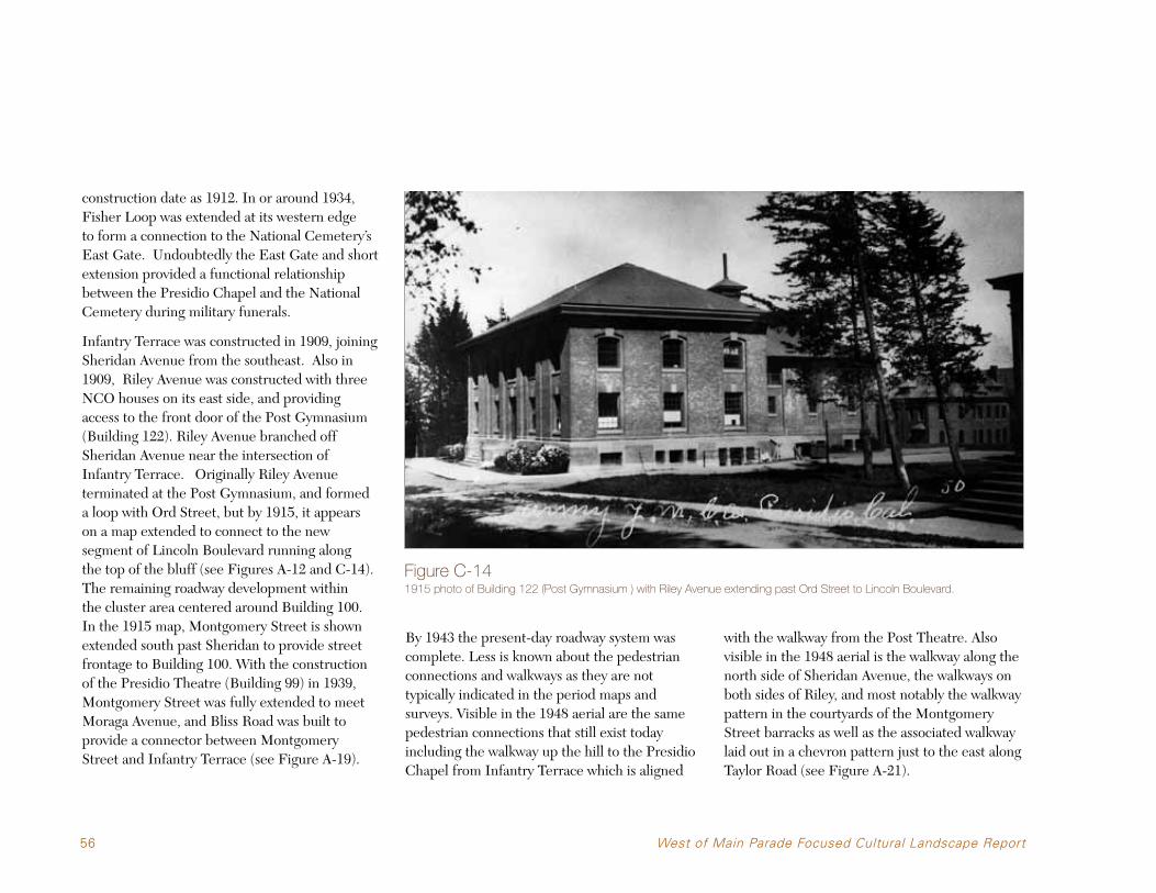
56 West of Main Parade Focused Cultural Landscape Report
construction date as 1912. In or around 1934, Fisher Loop was extended at its western edge to form a connection to the National Cemetery’s East Gate. Undoubtedly the East Gate and short extension provided a functional relationship between the Presidio Chapel and the National Cemetery during military funerals.
Infantry Terrace was constructed in 1909, joining Sheridan Avenue from the southeast. Also in 1909, Riley Avenue was constructed with three NCO houses on its east side, and providing access to the front door of the Post Gymnasium (Building 122). Riley Avenue branched off Sheridan Avenue near the intersection of Infantry Terrace. Originally Riley Avenue terminated at the Post Gymnasium, and formed a loop with Ord Street, but by 1915, it appears on a map extended to connect to the new segment of Lincoln Boulevard running along the top of the bluff (see Figures A-12 and C-14). The remaining roadway development within the cluster area centered around Building 100. In the 1915 map, Montgomery Street is shown extended south past Sheridan to provide street frontage to Building 100. With the construction of the Presidio Theatre (Building 99) in 1939, Montgomery Street was fully extended to meet Moraga Avenue, and Bliss Road was built to provide a connector between Montgomery Street and Infantry Terrace (see Figure A-19).
By 1943 the present-day roadway system was complete. Less is known about the pedestrian connections and walkways as they are not typically indicated in the period maps and surveys. Visible in the 1948 aerial are the same pedestrian connections that still exist today including the walkway up the hill to the Presidio Chapel from Infantry Terrace which is aligned
with the walkway from the Post Theatre. Also visible in the 1948 aerial is the walkway along the north side of Sheridan Avenue, the walkways on both sides of Riley, and most notably the walkway pattern in the courtyards of the Montgomery Street barracks as well as the associated walkway laid out in a chevron pattern just to the east along Taylor Road (see Figure A-21).
Figure C-141915 photo of Building 122 (Post Gymnasium ) with Riley Avenue extending past Ord Street to Lincoln Boulevard.
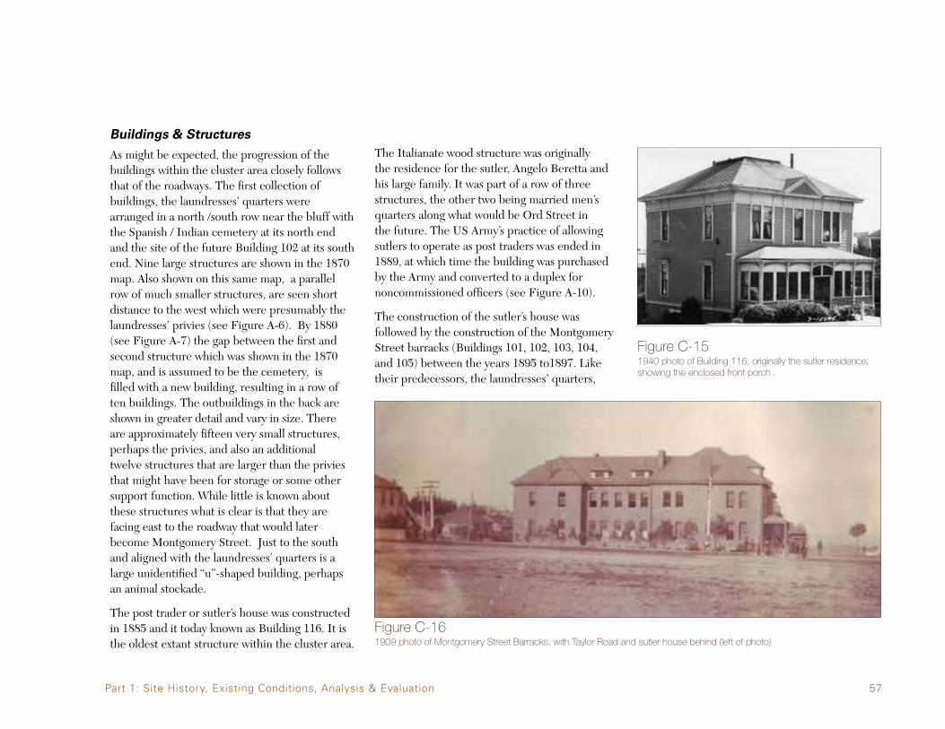
57
Buildings & Structures
As might be expected, the progression of the buildings within the cluster area closely follows that of the roadways. The first collection of buildings, the laundresses’ quarters were arranged in a north /south row near the bluff with the Spanish / Indian cemetery at its north end and the site of the future Building 102 at its south end. Nine large structures are shown in the 1870 map. Also shown on this same map, a parallel row of much smaller structures, are seen short distance to the west which were presumably the laundresses’ privies (see Figure A-6). By 1880 (see Figure A-7) the gap between the first and second structure which was shown in the 1870 map, and is assumed to be the cemetery, is filled with a new building, resulting in a row of ten buildings. The outbuildings in the back are shown in greater detail and vary in size. There are approximately fifteen very small structures, perhaps the privies, and also an additional twelve structures that are larger than the privies that might have been for storage or some other support function. While little is known about these structures what is clear is that they are facing east to the roadway that would later become Montgomery Street. Just to the south and aligned with the laundresses’ quarters is a large unidentified “u”-shaped building, perhaps an animal stockade.
The post trader or sutler’s house was constructed in 1885 and it today known as Building 116. It is the oldest extant structure within the cluster area.
The Italianate wood structure was originally the residence for the sutler, Angelo Beretta and his large family. It was part of a row of three structures, the other two being married men’s quarters along what would be Ord Street in the future. The US Army’s practice of allowing sutlers to operate as post traders was ended in 1889, at which time the building was purchased by the Army and converted to a duplex for noncommissioned officers (see Figure A-10).
The construction of the sutler’s house was followed by the construction of the Montgomery Street barracks (Buildings 101, 102, 103, 104, and 105) between the years 1895 to1897. Like their predecessors, the laundresses’ quarters,
Figure C-151940 photo of Building 116, originally the sutler residence, showing the enclosed front porch .
Figure C-161909 photo of Montgomery Street Barracks, with Taylor Road and sutler house behind (left of photo)
Part 1: Site History, Existing Conditions, Analysis & Evaluation
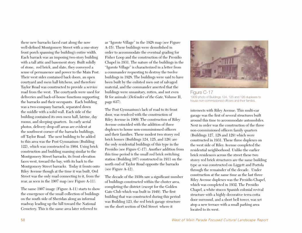
58 West of Main Parade Focused Cultural Landscape Report
these new barracks faced east along the now well-defined Montgomery Street with a one-story front porch spanning the building’s entire width. Each barrack was an imposing two-story building with a tall attic and basement story. Built solidly of stone, red brick, and slate, they conveyed a sense of permanence and power to the Main Post. Their west sides contained back doors, an open courtyard and mess hall kitchens, and therefore Taylor Road was constructed to provide a service road from the west. The courtyards were used for deliveries and back-of-house functions supporting the barracks and their occupants. Each building was a two-company barrack, separated down the middle with a solid wall. Each side of the building contained its own mess hall, latrine, day rooms, and sleeping quarters. In early aerial photos, delivery drop-off areas are evident at the southwest corner of the barracks buildings, off Taylor Road. The next building to be added to this area was the Post Gymnasium (Building 122), which was constructed in 1904. Using brick construction and building massing similar to the Montgomery Street barracks, its front elevation faces west, toward the bay, with its back to the Montgomery Street barracks. Today it fronts onto Riley Avenue though at the time it was built, Ord Street was the only road connecting to it, from the rear, as seen in the 1907 map (see Figure A-11).
The same 1907 image (Figure A-11) starts to show the emergence of the small collection of buildings on the south side of Sheridan along an informal roadway leading up the hill toward the National Cemetery. This is the same area later referred to
as “Igorote Village” in the 1928 map (see Figure A-15). These buildings were demolished in order to accommodate the eventual grading for Fisher Loop and the construction of the Presidio Chapel in 1931. The nature of the buildings in the “Igorote Village” is characterized in a letter from a commander requesting to destroy the twelve buildings in 1928. The buildings were said to have been built by the enlisted men out of salvaged material, and the commander asserted that the buildings were unsanitary, rotten, and not even fit for animals (Defender of the Gate, Volume II, page 637).
The Post Gymnasium’s lack of road to its front door, was resolved with the construction of Riley Avenue in 1909. The construction of Riley Avenue coincided with the addition of three duplexes to house non-commissioned officers and their families. These modest two storey red brick homes (Buildings 124, 125, and 126) are the only residential buildings of this type in the Presidio (see Figure C-17). Another addition from this time period is the small red brick switching station (Building 107) constructed in 1911 on the north end of Taylor Road opposite the barracks (see Figure A-12).
The decade of the 1930s saw a significant number of buildings constructed within the cluster area, completing the district (except for the Golden Gate Club which was built in 1949). The first building that was constructed during this period was Building 123, the red brick garage structure on the short section of Ord Street where it
intersects with Riley Avenue. This multi-car garage was the first of several structures built around this time to accommodate automobiles. Next in order was the construction of the three non-commissioned officers family quarters (Buildings 127, 128 and 129) which were constructed in 1931. These three duplexes on the west side of Riley Avenue completed the residential neighborhood. Unlike the earlier brick residences across the street these two storey red brick structures are the same building type as was constructed on Liggett and Portola through the remainder of the decade. Under construction at the same time as the last three Riley Avenue duplexes was the Presidio Chapel, which was completed in 1932. The Presidio Chapel, a white stucco Spanish colonial revival structure with a highly decorative terra cotta door surround, and a short bell tower, was set atop a new terrace with a small parking area located to its west.
Figure C-171909 photo of Buildings 124, 125 and 126 duplexes to house non-commissioned officers and their familes.
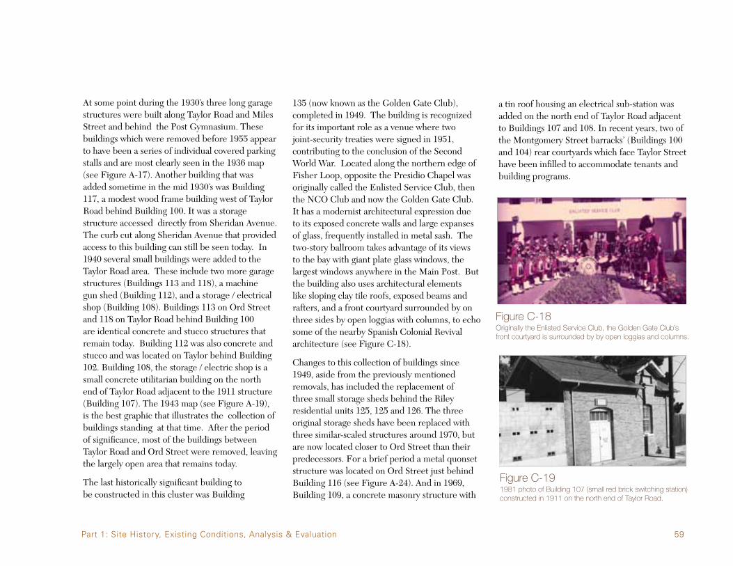
59
At some point during the 1930’s three long garage structures were built along Taylor Road and Miles Street and behind the Post Gymnasium. These buildings which were removed before 1955 appear to have been a series of individual covered parking stalls and are most clearly seen in the 1936 map (see Figure A-17). Another building that was added sometime in the mid 1930’s was Building 117, a modest wood frame building west of Taylor Road behind Building 100. It was a storage structure accessed directly from Sheridan Avenue. The curb cut along Sheridan Avenue that provided access to this building can still be seen today. In 1940 several small buildings were added to the Taylor Road area. These include two more garage structures (Buildings 113 and 118), a machine gun shed (Building 112), and a storage / electrical shop (Building 108). Buildings 113 on Ord Street and 118 on Taylor Road behind Building 100 are identical concrete and stucco structures that remain today. Building 112 was also concrete and stucco and was located on Taylor behind Building 102. Building 108, the storage / electric shop is a small concrete utilitarian building on the north end of Taylor Road adjacent to the 1911 structure (Building 107). The 1943 map (see Figure A-19), is the best graphic that illustrates the collection of buildings standing at that time. After the period of significance, most of the buildings between Taylor Road and Ord Street were removed, leaving the largely open area that remains today.
The last historically significant building to be constructed in this cluster was Building
135 (now known as the Golden Gate Club), completed in 1949. The building is recognized for its important role as a venue where two joint-security treaties were signed in 1951, contributing to the conclusion of the Second World War. Located along the northern edge of Fisher Loop, opposite the Presidio Chapel was originally called the Enlisted Service Club, then the NCO Club and now the Golden Gate Club. It has a modernist architectural expression due to its exposed concrete walls and large expanses of glass, frequently installed in metal sash. The two-story ballroom takes advantage of its views to the bay with giant plate glass windows, the largest windows anywhere in the Main Post. But the building also uses architectural elements like sloping clay tile roofs, exposed beams and rafters, and a front courtyard surrounded by on three sides by open loggias with columns, to echo some of the nearby Spanish Colonial Revival architecture (see Figure C-18).
Changes to this collection of buildings since 1949, aside from the previously mentioned removals, has included the replacement of three small storage sheds behind the Riley residential units 125, 125 and 126. The three original storage sheds have been replaced with three similar-scaled structures around 1970, but are now located closer to Ord Street than their predecessors. For a brief period a metal quonset structure was located on Ord Street just behind Building 116 (see Figure A-24). And in 1969, Building 109, a concrete masonry structure with
a tin roof housing an electrical sub-station was added on the north end of Taylor Road adjacent to Buildings 107 and 108. In recent years, two of the Montgomery Street barracks’ (Buildings 100 and 104) rear courtyards which face Taylor Street have been infilled to accommodate tenants and building programs.
Figure C-18Originally the Enlisted Service Club, the Golden Gate Club’s front courtyard is surrounded by by open loggias and columns.
Figure C-191981 photo of Building 107 (small red brick switching station) constructed in 1911 on the north end of Taylor Road.
Part 1: Site History, Existing Conditions, Analysis & Evaluation

60 West of Main Parade Focused Cultural Landscape Report
Small Scale Features
Small-scale features are found throughout the site and help define the character of the cultural landscape. Developed in association with the roadways, buildings, and the occupancy of the site these features often reflect the influences of the period within which they were added.
Small-scale features associated with the oldest surviving structures include the walkways between Montgomery Street narracks structures and the walkway and brick drainage swales along Ord Street.
The Riley Avenue residential neighborhood includes a number of paths and drainage swales which probably date from the period of significance as well as recent additions such as chain link fencing and clothesline poles.
The Fisher Loop area has a number of limited small scale features directly associated with its construction in the 1930’s while the Presidio Chapel in particular contains a number on recent additions such as memorial plaques and remembrances.
For a listing of the small scale features see Table 2 on page 40. The table notes which small features dates before the end of the period of significance. The following images include all of the small scale features listed in Table 2 as well as a variety of miscellaneous images of small scale features that are found throughout the district. These miscellaneous small scale features are too numerous to list and map and in most cases are likely to date from after the end of the period of significance. However their combined character and feel do contribute to the cultural landscape of the district.
F.24Stucco sign
F.25Plaque honoring Charles B. Stone, Jr. C.O. Presidio, 1930-1933

61
F.26Post Chapel sign
F.27Memorial garden
F.29U.S. Army Chaplins Memorial
F.28Viet Nam memorial
F.30Stairs and cheek walls
Part 1: Site History, Existing Conditions, Analysis & Evaluation

62 West of Main Parade Focused Cultural Landscape Report
F.31D’ Day Memorial
F.32Drip-line concrete swale
F.33Drainage head wall

63
F.34Cast stone lamp post
F.35Concrete driveway curb-cut
F.36Metal pipe railings
Part 1: Site History, Existing Conditions, Analysis & Evaluation

64 West of Main Parade Focused Cultural Landscape Report
F.37Concrete drainage swale
F.37Concrete drainage swale
F.37Concrete drainage swale

65
F.38Metal boot scraper in porch stoop
F.39Concrete apron to Building 123
F.40Concrete apron to Building 113
Part 1: Site History, Existing Conditions, Analysis & Evaluation
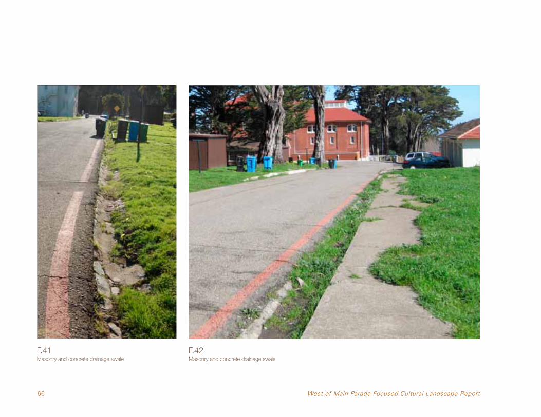
66 West of Main Parade Focused Cultural Landscape Report
F.41Masonry and concrete drainage swale
F.42Masonry and concrete drainage swale

67
F.43Metal pipe railings
F.44Concrete wall
F.45Manhole cover
F.46Garbage can pad
Part 1: Site History, Existing Conditions, Analysis & Evaluation

68 West of Main Parade Focused Cultural Landscape Report
MISCELLANEOUS
Pedestrian path light at Buildings 122 and 104 Parking lot light, west of Building 130 Parking lot light, west of Building 103

69
Walkway railing and lights, between Building 122 and 104 Basement entry walkway and walls of Building 104 Walkway and furnishings north of Building 122
Part 1: Site History, Existing Conditions, Analysis & Evaluation

70 West of Main Parade Focused Cultural Landscape Report
Building signage at 122 Two-sided kiosk at Building 104 Active fire hydrant, Riley Avenue c. 1950

71
Water valve cover for abandoned water system, along Riley Avenue. Note 1942 date on outer rim Manholes for active utilities
Part 1: Site History, Existing Conditions, Analysis & Evaluation

72 West of Main Parade Focused Cultural Landscape Report
Tiled courtyard entry for Building 135 Clothesline near Riley Avenue housing, c. 1960s

73
C.3 Assessing Historic Integrity
Integrity in a cultural landscape relates to its ability to convey its significance. An integrity assessment evaluates the existence and condition of landscape features from a site’s period of significance, using individual qualities of integrity as part of the overall assessment. The National Register criteria recognize seven aspects or qualities that, in various combinations, define integrity. To retain historic integrity a property must possess several, and usually most, of the aspects. Within the context of the Presidio NHL, all seven aspects of integrity are important.
The seven aspects of integrity are defined in National Register Bulletin 15: How to Apply the National Register Criteria for Evaluation. They are as follows:
•Location—theplacewheretheculturallandscape was constructed or the landscape where the historic event occurred.
•Design—thecombinationofelementsthatcreate the form, plan, space, structure, and style of a cultural landscape.
•Setting—thephysicalenvironmentofthecultural landscape.
•Materials—thephysicalelementsthatwerecombined or deposited during the particular period(s) of time and in a particular pattern or configuration to form the cultural landscape.
•Workmanship—thephysicalevidenceofthecrafts of a particular culture or people during any given period in history or prehistory.
•Feeling—aculturallandscape’sexpressionofthe aesthetic or historic sense of a particular period of time.
•Association—thedirectlinkbetweentheimportant historic event or person and a cultural landscape.
Assessing the integrity of a growing and changing landscape is a complex matter. Within the West of Main Parade cluster area, trees and plants have grown and died, buildings have been constructed and demolished and land uses have changed since the US Army has left the post. However, the general character of the West of Main Parade cluster area has remained basically the same as it was at the end of the period of significance. Few new elements have been added to this landscape since the period of significance ended, and the removal of historic elements has been limited. For example, eight buildings have been demolished within the Taylor Road/Ord Street area since 1945, which clearly has impacted the historic character of this area, but these demolitions have not affected the character of the Riley Avenue neighborhood nor the area around the Presidio Chapel and Golden Gate Club.
In all, the West of the Main Parade cluster area retains integrity as a contributing element of the NHL, and each sub-area retains integrity as well. The following section analyzes the aspects of integrity for each sub-area, noting where
Figure C-201950s aerial photograph.
aspects of integrity remain and where they have been dimished since the end of the period of significance.
Part 1: Site History, Existing Conditions, Analysis & Evaluation

74 West of Main Parade Focused Cultural Landscape Report
Presidio Chapel and Golden Gate Club
LINC
OLN
BLVD
.
HALLECK ST.
MONTGOMERY ST.
MO
RAG
A A
VE.
GRAHAM ST.
MESA ST.
FUNSTON AVE.
PRESIDIO
BLVD
.
Location: The Presidio Chapel and Golden Gate Club retain integrity of location because they continue to offer places of worship and gathering to the community in the same location they were originally designed and constructed.
Design: This landscape area retains integrity of design based on its continued display of the characteristics that defined its original design. The location and patterns of the plants on the site, although not all original plant materials, for the most part perpetuates the original site design. The only area where the historic planting design has been compromised is east of the chapel where encroaching volunteer vegetation has turned an open bluff into a wooded one. Fisher Loop, listed as a contributing road corridor, was originally constructed at the same time as the Presidio Chapel (1932) and retains
most of its original alignment and features. The addition of paved parking lot north of the Golden Gate Club took place after the period of significance and altered Fisher Loop somewhat but not enough to compromise its integrity. Changes to the parking lot west of the Chapel after the end of the period of significance (1945) have also altered its original size and removed portions of the historic forest. These two parking lots, however, do not compromise the design integrity of the overall site.
Setting: The Presidio Chapel and Golden Gate Club area retains integrity of setting. Still somewhat isolated from the Main Post and its day-to-day activity, this area occupies a tranquil setting, elevated somewhat above the Main Post with attractive views to the bay. Little encroachment from other Main Post developments over the years has disturbed this setting.
Materials: This area retains integrity of materials. The asphalt roads have been resurfaced and otherwise repaired over the years but this work was done using asphalt, the original material. Most of the historic circulation features such as sidewalks and stairs consist of original materials. Landscape materials which
make up the ground cover and foundation plantings have undergone the most change, and in many cases, the original plants are not known. Based on evidence provided by historic photographs and a plant inventory, it appears that contemporary plant materials that replaced the historic materials are compatible in size and scale, resulting in a continuity of form for landscape materials.
Workmanship: The Presidio Chapel and Golden Gate Club area retains integrity of workmanship primarily for the buildings and circulation systems on the site. The buildings have undergone very few changes. The roads and sidewalks have undoubtedly been repaired over the years but they retain most aspects of their original workmanship. Later landscape elements north and east of the chapel, specifically tiled exterior pads and the ramp leading to the enclosed side loggia, exhibit a lower level of workmanship but these do not detract from the surrounding historic features.
Feeling: The landscape around the Presidio Chapel retains integrity of feeling, though this aspect of integrity is also strongly compromised by tree growth that has filled in formerly open areas. The chapel originally had a feeling of openness with a commanding presence

75
overlooking the Main Post toward its east side. Today, this feeling has been compromised by the tree growth that has filled in the open area to the east of the chapel and destroyed its views and visibility from below. The landscape around the Golden Gate Club retains integrity of feeling. Its dramatic views to the bay are still present through the Monterey Cypress trees that stand to the north and east of the building. Both the chapel and the club retain the feeling of being removed from the daily activity of the Main Post, providing a historic sense of both buildings’ original use and special status as places for worship, recreation and social activities.
Association: The landscapes surrounding the Presidio Chapel and the Golden Gate Club retain integrity of association. They are visible reminders of Army life, as places where military personnel and their families would worship and recreate. The connection between the chapel and the cemetery tells a story of military funerals and burials. And, because the chapel is still used as a place of worship and the Golden Gate Club still hosts community gatherings and social events, the link between their historic use and their current-day use helps enforce the original association between the users and the landscape.
Figure C-21Monterey Cypress trees that stand to the north and east of the Golden Gate Club.
Part 1: Site History, Existing Conditions, Analysis & Evaluation

76 West of Main Parade Focused Cultural Landscape Report
F.21 F.30
F.31F.29
F.22
F.28F.27
F.25
F.24
F.26
F.35
F.36
F.32
F.34
F.37
F.37F.37
F.33
F.40
F.37
F.38 F.38 F.38
F.39
F.37 F.37F.37 F.37
F.42
F.41
F.44
F.46
F.45
F.43
F.19F.20
Figure C-22Contributing landscape
features - Presidio Chapel and Golden Gate Club.
INFANTRY TERRACE
SHER
IDA
N A
VEN
UE
FISH
ER L
OO
P
FISHER LOOP
135
130

77
•AconcretestaircaseontheslopeeastoftheChapel, connecting the Chapel side yard to Infantry Terrace below.
•Thetriangularslopingopenspacenorthofthe Chapel surrounding all three sides by Fisher Loop, with a concrete sidewalk on its eastern edge.
•Treeseithersinglyoringroupsinthetriangular open space or east of it, in the area between Fisher Loop and Infantry Terrace.
•HistoricforestsectionssouthandwestoftheChapel.
•TheovallawnpanelsouthoftheGoldenGate Club, including the asphalt driveway that surrounds it, and a cluster of trees at its southeast edge.
Contributing Landscape Features
•Thesystemofsidewalkseastofthebuilding.
•Theslopinglawnareathatwrapsthebuilding’s north and east side, extending from the building to the Infantry Terrace/Sheridan Avenue curb.
•Treesinthislawnlocatednorthandeastofthe building close to the road.
•Intheentrycourtyard,thecentralwalkwayleading to the front door, the concrete walk parallel to the driveway, and the oval shaped planter area defined by a rounded curb.
•PanoramicviewstothebayfromtheGoldenGate Club.
EXTANT HISTORIC FEATURES
Road corridor
Sidewalk/paved surfaces
Historic buildings
Foundation planting/lawn areas
Trees, palms and hedges
NON-HISTORIC OR MISSING FEATURES
Buildings from the end of the Period of Significance (1945) now non-extant
Tree planting from after 1945
Non-contributing buildings and additions
SMALL SCALE FEATURES
Both historic and non-historic small scale features (see Table 2 on page 40)
F.23
Note: Contributing landscape features are shown in color. Areas without integrity and/or not significant are in white.
Part 1: Site History, Existing Conditions, Analysis & Evaluation

78 West of Main Parade Focused Cultural Landscape Report
Riley Avenue
LINC
OLN
BLVD
.
HALLECK ST.
MONTGOMERY ST.
MO
RAG
A A
VE.
GRAHAM ST.
MESA ST.
FUNSTON AVE.
PRESIDIO
BLVD
.
Location: The Riley Avenue residential area has integrity of location because it continues as a residential enclave on the edge of the Main Post.
Design: The landscape of this area retains integrity of design based of its continued display of the characteristics that defined its original design. Simple foundation plantings around each building, with a few large trees sprinkled through the site, characterize its design. The plants that exist today around the residences may not be original plant materials, but for the most part they perpetuate the original site design.
Setting: The Riley Avenue area retains integrity of setting. It is still a somewhat isolated residential enclave surrounded by busy roads. The new use for the former Post Gymnasium as office and exhibit space for WDFM, does not compromise its setting. There are no new buildings or landscape features from outside the period of significance within this area.
Materials: This area retains integrity of materials. The asphalt roads have been resurfaced and otherwise repaired over the years but this work was done using asphalt, the original material. Most of the historic circulation features such as sidewalks and stairs consist of original materials. Contemporary plant materials that replaced the historic materials are compatible replacements. Large trees growing randomly within the area are remnants of the historic
forest. However, in recent years many of these large trees have died or been removed due to declining health. Adjacent to Building 122, some new trees of the same species have recently been planted to augment this loss.
Workmanship: The Riley Avenue area retains integrity of workmanship primarily for the buildings and circulation systems on the site. The buildings, roads and sidewalks have undergone very few changes.
Figure C-23Residential character of Riley Avenue.

79
Feeling: The area retains integrity of feeling. It is a landscape of small houses and small landscape features, retaining the original feeling of simplicity and domesticity. The random placement of large trees on the edges of the residential areas maintains a historic reference to the historic forest that once occupied this site.
Association: This area retains integrity of association although it has been diminished by new uses of some contributing buildings. The most significant change in association on Riley Avenue is due to Building 122’s change of use. The Army used this building first as a gymnasium for soldiers, then in the late 20th century, as an arts and crafts center for military families. Today it is used by the Walt Disney Family Museum as a gallery and curatorial facility. This new use detracts from Riley Avenue’s integrity of association, but because the majority of the street continues to be used for housing, the link between its history and its landscape can still be understood.
Figure C-24Recently rehabilitated Building 122 as a gallery and curatorial facility.
Part 1: Site History, Existing Conditions, Analysis & Evaluation
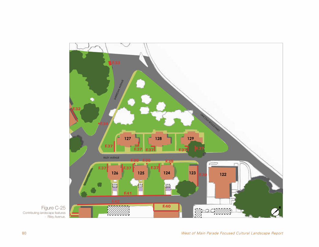
80 West of Main Parade Focused Cultural Landscape Report
Figure C-25Contributing landscape features
- Riley Avenue.
F.21 F.30
F.31F.29
F.22
F.28F.27
F.25
F.24
F.26
F.35
F.36
F.32
F.34
F.37
F.37F.37
F.33
F.40
F.37
F.38 F.38 F.38
F.39
F.37 F.37F.37 F.37
F.42
F.41
F.44
F.46
F.45
F.43
F.19F.20
RILEY AVENUE
SHER
IDA
N A
VEN
UE
LINCOLN BOULEVARD
127 128 129
126 125 124 123 122

81
•Theflatlawnareasaroundtheresidentialbuildings with foundation plantings surrounding each building. This also includes a network of narrow concrete sidewalks set in the lawn.
•TheroadcorridorsofRiley,OrdandLincoln retain much of their original width and layout.
Contributing Landscape Features
•PalmsandhedgesouthofBuilding126,adjacent to Sheridan Avenue.
•LinearviewstothebayfromRileyAvenue.
EXTANT HISTORIC FEATURES
Road corridor
Sidewalk/paved surfaces
Historic buildings
Foundation planting/lawn areas
Trees, palms and hedges
NON-HISTORIC OR MISSING FEATURES
Buildings from the end of the Period of Significance (1945) now non-extant
Tree planting from after 1945
Non-contributing buildings and additions
SMALL SCALE FEATURES
Both historic and non-historic small scale features (see Table 2 on page 40)
F.23
Note: Contributing landscape features are shown in color. Areas without integrity and/or not significant are in white.
Part 1: Site History, Existing Conditions, Analysis & Evaluation

82 West of Main Parade Focused Cultural Landscape Report
Backs of the Montgomery Street Barracks, Taylor Road and Ord Street
LINC
OLN
BLVD
.
HALLECK ST.
MONTGOMERY ST.
MO
RAG
A A
VE.
GRAHAM ST.
MESA ST.
FUNSTON AVE.
PRESIDIO
BLVD
.
Location: The area between defined by Sheridan Avenue, Taylor Road, Lincoln Boulevard, and Ord Street retains integrity of location because it continues as a parking and service area, in its original relationship to the Main Parade and barracks.
Design: The landscape of this area lacks integrity of design because it is missing many of the buildings that characterized its historic design. With only the original road network remaining, the original design of the area is only partially visible today. The backyards and courtyards of the Montgomery Street Barracks retain only fragments of their original sidewalks, truck loading areas, and landscape materials. The back yard of Building 106 alone retains design integrity. With only the original road network remaining, the original design of the area is only partially visible today.
Setting: The Taylor Road/Ord Street area retains only partial integrity of its setting. The physical environment has changed due to demolition of historic buildings, and due to the infilling of Building 104’s courtyard.
Materials: This area retains integrity of materials. The asphalt roads have been resurfaced and
otherwise repaired over the years but this work was done using asphalt, the original material. Most of the historic circulation features such as sidewalks and stairs consist of original materials. There are original stone-lined runnels on Ord Street. A few historic plant materials, such as the Canary Island date palms remain from the period of significance.
Figure C-26Stone-lined runnels on Ord Street.

83
Workmanship: This area retains partial integrity of workmanship. Because most of the buildings that filled this area during the period of significance are no longer extant, the integrity of the area’s workmanship is diminished.
Feeling: The area retains partial integrity of feeling. It retains its functional, back-of-house feeling. As a present-day parking lot, it evokes much of the functional feeling it would have had during the period of significance. The flat grass areas and behind, and the sloping side yards between, the Montgomery Street barracks still serve as service areas with modest planting. New features, such as those associated with the WDFM parking area, are compatible in feeling with the historic surrounds. What compromises the integrity of its feeling is the openness of the area due to building removal, creating an expansive feeling that did not exist historically.
Association: This area retains partial integrity of association. Its continued use for parking and to provide service access to the backs of buildings allows it to retain its historic associations to the Montgomery Street barracks and to the residences facing Riley Avenue. Demolition of buildings between Taylor Road and Ord Street has altered historic associations from a once-densely-built area to an open space. New uses in the barracks like the Walt Disney Family
Museum and other office tenants, as well as empty barracks, have altered the historical way the Army used this area. The infilling of the Building 104 courtyard has changed its association as a service area, although the other Montgomery Street barracks’ courtyards have remained largely unchanged. The west sides of the barracks continue to act as the service side of the buildings and Taylor Road continues as a service drive, which partially supports the historic association between the area’s history and its landscape.
Contributing Landscape Features
•TheroadcorridorsofTaylor,Ord,Lincoln,and Sheridan.
•ThelandscapenorthofBuilding116withaflat lawn area marked by two Canary Island date palms.
•Flatgrassyareasintherearcourtyardsofthe Montgomery Street barracks, including a remaining truck loading area behind Building 105.
•Thewalkways/circulationpatternswithinthe courtyards of Buildings 101 and 102.
•Sideyardsbetweenthebarracks,Buildings 101/102 and 102/103 retain their sloping topography and grass planting.
•ThelandscapeyardbehindBuilding106,containing lawn, shrubs and one large tree.
•Viewstothebacksofthebarracks,Buildings 100 and 101 from Sheridan Avenue.
•LinearviewstothebayfromTaylorRoad.
Part 1: Site History, Existing Conditions, Analysis & Evaluation

84 West of Main Parade Focused Cultural Landscape Report
F.21 F.30
F.31F.29
F.22
F.28F.27
F.25
F.24
F.26
F.35
F.36
F.32
F.34
F.37
F.37F.37
F.33
F.40
F.37
F.38 F.38 F.38
F.39
F.37 F.37F.37 F.37
F.42
F.41
F.44
F.46
F.45
F.43
F.19F.20
Figure C-727Contributing landscape features - Backs of Montgomery Street Barracks, Taylor Road and Ord Street.
TAYLOR ROAD
ORD STREET
113116
101 102 103
SHER
IDA
N A
VEN
UE

85
F.21 F.30
F.31F.29
F.22
F.28F.27
F.25
F.24
F.26
F.35
F.36
F.32
F.34
F.37
F.37F.37
F.33
F.40
F.37
F.38 F.38 F.38
F.39
F.37 F.37F.37 F.37
F.42
F.41
F.44
F.46
F.45
F.43
F.19F.20
LINCOLN BOULEVARD
108 107
104 105 106
EXTANT HISTORIC FEATURES
Road corridor
Sidewalk/paved surfaces
Historic buildings
Foundation planting/lawn areas
Trees, palms and hedges
NON-HISTORIC OR MISSING FEATURES
Buildings from the end of the Period of Significance (1945) now non-extant
Tree planting from after 1945
Non-contributing buildings and additions
SMALL SCALE FEATURES
Both historic and non-historic small scale features (see Table 2 on page 40)
F.23
Note: Contributing landscape features are shown in color. Areas without integrity and/or not significant are in white.
Part 1: Site History, Existing Conditions, Analysis & Evaluation

86 West of Main Parade Focused Cultural Landscape Report
Taylor Road and Infantry Terrace, South of Sheridan
LINC
OLN
BLVD
.
HALLECK ST.
MONTGOMERY ST.
MO
RAG
A A
VE.
GRAHAM ST.
MESA ST.
FUNSTON AVE.
PRESIDIO
BLVD
.
Location: The area defined by Sheridan Avenue, Infantry Terrace, and Taylor Road, retains integrity of location because it continues as a parking and service area.
Design: The landscape of this area retains partial integrity of design because it is missing Building 117 and part of the tree row immediately east of it. The original road network remains but many of the historic trees are missing, meaning the original design of the area is only partially visible today. The one-story structure partially infilling Building 100’s courtyard changes the historic design of the courtyard which was originally an open space.
Setting: This area retains partial integrity of its setting. The physical environment has changed due to demolition of historic buildings and the decline and partial removal of the tree row parallel to Taylor Road, as well as volunteer trees growing west of Building 118, filling the triangular area between Infantry Terrace and Sheridan Avenue.
Materials: This area retains partial integrity of materials. The asphalt roads have been resurfaced and otherwise repaired over the years but this work was done using asphalt, the original material. A few historic plant materials, such as mature Monterey Cypress trees remain from the period of significance. Demolition of Building 117 also detracts from the area’s material integrity.
Workmanship: This area retains partial integrity of workmanship only for one building and the road circulation systems on the site. Because one of the two original buildings is no longer extant, the integrity of the area’s workmanship is diminished.
Feeling: The area retains partial integrity of feeling. It fully retains its functional, back-of-house feeling. As a present-day service road with a garage on it, it evokes much of the feeling it would have had during the period of significance. The flat grass area behind Building 118 is largely unchanged. The mature Monterey Cypress trees reinforce the original feeling of enclosure or screening provided by the historic trees. The one story structure in the Building 100 courtyard detracts from the courtyard’s original feeling as a rear service area.
Association: This area has partial integrity of association due to the demolition of Building 117 and due to the change of use of Building 100. Originally occupied by the Army as a barrack, its new use as an office building with meeting and exhibition space compromises the associations between the area’s history and its landscape. Building 118, built as a garage in 1940, will remain a garage.
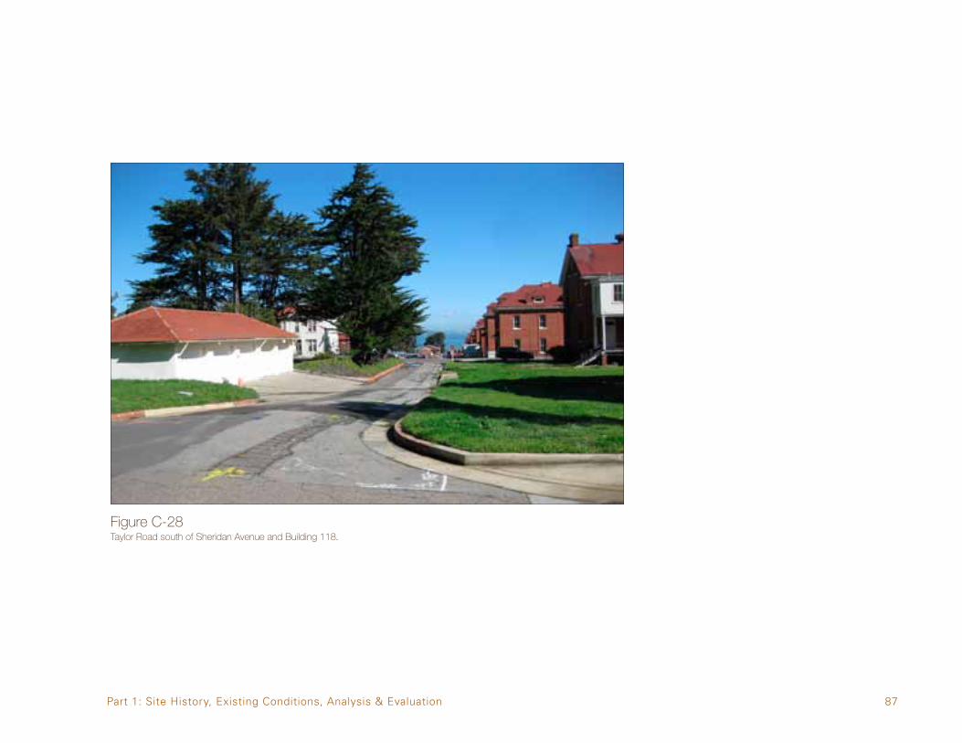
87
Figure C-28Taylor Road south of Sheridan Avenue and Building 118.
Part 1: Site History, Existing Conditions, Analysis & Evaluation

88 West of Main Parade Focused Cultural Landscape Report
F.21 F.30
F.31F.29
F.22
F.28F.27
F.25
F.24
F.26
F.35
F.36
F.32
F.34
F.37
F.37F.37
F.33
F.40
F.37
F.38 F.38 F.38
F.39
F.37 F.37F.37 F.37
F.42
F.41
F.44
F.46
F.45
F.43
F.19F.20
Figure C-29Contributing landscape features - Taylor Road and Infantry Terrace, South of Sheridan.
SHER
IDA
N A
VEN
UE
INFANTRY TERRACE
BLIS
S R
OA
D
TAYLOR ROAD
•TheroadcorridorsofTaylorRoad,InfantryTerrace, and Sheridan Avenue.
•Building118.
•LinearviewstothebayfromTaylorRoad.
118
100
EXTANT HISTORIC FEATURES
Road corridor
Sidewalk/paved surfaces
Historic buildings
Foundation planting/lawn areas
Trees, palms and hedges
NON-HISTORIC OR MISSING FEATURES
Buildings from the end of the Period of Significance (1945) now non-extant
Tree planting from after 1945
Non-contributing buildings and additions
SMALL SCALE FEATURES
Both historic and non-historic small scale features (see Table 2 on page 40)
F.23
Note: Contributing landscape features are shown in color. Areas without integrity and/or not significant are in white.
Contributing Landscape Features

89
PART 2. TREATMENT
This chapter provides treatment recommendations for the West of Main Parade cluster area, based on the four separate sub-areas that make it up. The primary treatment strategy for the Presidio at large and this cluster area in particular is rehabilitation. Rehabilitation is defined in the Secretary of the Interior’s Standards for the Treatment of Historic Properties. The treatment recommendations which follow take into account the period of significance for the area and the integrity of the features that remain from that time period.
General Treatment Recommendations:
•Maintainandprotecthistorictreesandplant materials to allow them to reach the end of their natural lives. When historic
plant materials must be removed because they have reached the end of their life spans, or because their size and structure creates a safety hazard, remove them and replace them in-kind whenever possible. If a substitute species is being considered instead of an in-kind replacement, the substitute species must have the same character as the original being replaced. It must be similar in terms of type, form, shape, and scale.
•Avoiddisturbingknownorpredictedarchaeological resources.
•Retainsmall-scalesitefeatures,suchasmanholecovers, fire hydrants, boot scrapers, stone landscape elements, etc. If replacement of these features becomes necessary, introduce new features that reflect the size, scale, texture, and color of the feature being replaced.
•ConformtothePresidioTruststandards6 when replacing streetlights and street signs. When introducing new elements such as street furniture, and way finding and directional signage, conform to the Presidio Trust standards.
•Newsitefeaturesareallowedaspartofalandscape rehabilitation, but they must be located so as not to damage historic features or to compromise the integrity of an area.
•Locatenewsurfaceparkinginlow-integrityareas (such as former building pads) or areas lacking significant landscape features.
•Whererequiredbyaccessibilitystandards,thequantity and locations of ramps, curb cuts and ADA loading zones on historic roads to achieve universal access should have minimal impact on the historic scene and should be the minimum required to meet accessibility standards.
Part 2: Treatment
6 DRAFT Design Review & Permitting Process, Prepared for the Presidio Trust by Swinerton Management & Consulting, Inc., October 2009 (as an update to the Draft Tenant Handbook, 2007); DRAFT Presidio Landscape and Civil Standards, 2011.

90 West of Main Parade Focused Cultural Landscape Report
Presidio Chapel and Golden Gate Club
LINC
OLN
BLVD
.
HALLECK ST.
MONTGOMERY ST.
MO
RAG
A A
VE.
GRAHAM ST.
MESA ST.
FUNSTON AVE.
PRESIDIO
BLVD
.
Figure D-1The Golden Gate Club.
D1 Retain the historic plants that are noted on the Plant Inventory. Introduce replacement plants that are compatible with the historic plant palettes.D2 Retain the existing Monterey Cypress trees north and east of the Golden Gate Club and reinforce this grouping by adding new trees of the same species.D3 Retain the historic row of trees lining the National Cemetery fence and reinforce this row by adding new trees of the same species.D4 Retain historic width and alignment of Fisher Loop. Re-establish missing historic edges on curbs. Limit curbcuts and driveway cuts.D5 Retain the historic width and alignment of the circular driveway in front of the Golden Gate Club, especially the oval shape of the interior planted island.D6 Retain the historic width and alignment of the driveway on the south and east sides of the Presidio Chapel. D7 Retain the concrete stairs.D8 Maintain openness of open sloping open space.
Specific Recommendations
D9 Retain historic specimen trees.D10 Retain parking lot and improve its functionality and appearance.D11 Consider removal of non-historic trees from the area between Fisher Loop and Infantry Terrace to re-establish views.

91Part 2: Treatment
Figure D-2Specific recommendations - Presidio Chapel and Golden Gate Club.
INFANTRY TERRACE
SHER
IDA
N A
VEN
UE
D1
FISHER LOOP
D2
D2
D3
D4
FISHER LOO
P
D4
D5
D6
FISHER
LOO
P
D8
D9
D7
135
130
D10
D10
D11

92 West of Main Parade Focused Cultural Landscape Report
Riley Avenue
LINC
OLN
BLVD
.
HALLECK ST.
MONTGOMERY ST.
MO
RAG
A A
VE.
GRAHAM ST.
MESA ST.
FUNSTON AVE.
PRESIDIO
BLVD
.
Figure D-3Palm and hedge adjacent to Sheridan Avenue.
B1 Retain historic character of the open space around and between individual the residential buildings. Use screening hedges only at the outside limits of the neighborhood, but do not remove existing trees to do so.B2 Retain the historic plants that are noted on the Plant Inventory wherever possible. Introduce replacement plants that are compatible with the historic plant palettes.B3 Retain the existing historic road configuration of Riley Avenue. B4 Rehabilitate plantings adjacent to the residential buildings consistent with the sparse foundation plantings found during the period of significance.B5 Restore the character and pattern of the scattered planting of Monterey Cypress.B6 Retain and rehabilitate the historic walkways and drainage runnels adjacent to the housing units.B7 Consider restoring the small storage structures just west of Ord Street (behind Buildings 124 to 126) to their historic locations.
Specific Recommendations
B8 Retain the hedge row and palms.B9 Retain Costanoan Rumsen Carmel Tribe commemorative tree planted c. 2000 in historic tree location.

93Part 2: Treatment
Figure D-4Specific recommendations - Riley Avenue.
B1
B2
B3
B4
B5
B6
RILEY AVENUESHER
IDA
N A
VEN
UE
LINCOLN BOULEVARD
B5
B2
B6
B7 B7B7 B5
B4
B1
B8
127 128 129
126 125 124 123122
B5
B9

94 West of Main Parade Focused Cultural Landscape Report
Backs of the Montgomery Street Barracks, Taylor Road and Ord Street
LINC
OLN
BLVD
.
HALLECK ST.
MONTGOMERY ST.
MO
RAG
A A
VE.
GRAHAM ST.
MESA ST.
FUNSTON AVE.
PRESIDIO
BLVD
.
Figure D-5Taylor Road behind Montgomery Street Barracks..
Specific Recommendations
A1 Retain the historic plants that are noted on the Plant Inventory wherever possible. Introduce replacement plants that are compatible with the historic plant palettes.A2 Maintain the existing continuously sloping topography of Taylor Road and associated parking lot.A3 Retain the existing historic configuration of Taylor Road and Ord Street. A4 Rehabilitate and enhance the historic pattern of ornamental planting to enhance Sheridan Avenue’s role as an entry to the Main Post.A5 Introduce vegetative buffer or screening north of Sheridan Avenue (south of Building 116) to reinforce the fact that buildings formerly stood on this site and blocked the view.A6 Refer to the historic utilitarian character and light planting when replanting the barracks’ courtyards.A7 Restore missing sidewalks west of the barracks, bringing back their historic patterns and alignment, which includes a diagonal or chevron pattern and also includes crossed sidewalks in the courtyards.
A8 Plant cajeput trees (Melaleuca quinquenervia) trees behind each barrack to reinforce the historic character of uniformity among the Montgomery Street Barracks.A9 Match the simple design and limited plant palette of the new parking lot treatment behind Building 104 when designing the remainder of the Taylor Road parking lot to reinforce the historic character of uniformity.A10 Maintain the terracing of the barracks’ side yards and their utilitarian character. Avoid highly ornamental landscaped in the side yards.A11 Consider restoring the clump of vegetation at the southwest corner of Building 101 evident in historic aerials to both screen the back of the building from Sheridan Avenue and to frame the entry into the Main Parade from the west.A12 Retain the historic Canary Island date palms.A13 Retain the historic concrete apron at the front and side of Building 113.A14 Retain and/or rehabilitate the existing stone runnels on both sides of Ord Street whenever possible.A15 Retain the historic metal pipe railing south of Building 101.

95Part 2: Treatment
A16 Avoid new construction infill in remaining Montgomery Street Barracks courtyards.A17 Restore historic pattern of walks in courtyards of Buildings 101, 102, 103 and 105. A18 Use formerly built areas for new surface parking west of Taylor Road.A19 Retain the trees and landscape materials west of Building 106.
TAYLOR ROAD
ORD STREET
LINCOLN BOULEVARD
SHER
IDA
N A
VEN
UE
A14
A2
A4A5
A6
A7A8
A9
A10A11
A12
A13
A15
A14
A12
A3A8 A8A8
A6 A6A6
A7
A10A10
A3
A16A16 A16A16 A19
113116
107
101 102 103 104 105 106
108A18
A17A17A20
A8A8A8
Figure D-6Specific recommendations - Backs of Montgomery Street barracks, Taylor Road and Ord Street.
A9A2
A10
A20 Retain the views to the backs of the Barracks, Buildings 100 and 101 from Sheridan Avenue.A21 Re-establish truck loading areas at the south west corners of Buildings 102, 103, 104 and 105.
A21A21A21A21 A17 A17

96 West of Main Parade Focused Cultural Landscape Report
Taylor Road and Infantry Terrace, South of Sheridan
LINC
OLN
BLVD
.
HALLECK ST.
MONTGOMERY ST.
MO
RAG
A A
VE.
GRAHAM ST.
MESA ST.
FUNSTON AVE.
PRESIDIO
BLVD
.
Figure D-7Building 118.

97
Specific RecommendationsC1 Rehabilitate the hedgerow planting along the west side of Taylor Road. Consider alternate species to the existing Monterey Cypress to be consistent with the height of the hedgerow as it was originally maintained by the US Army.C2 Retain the existing historic configuration of Taylor Road, Bliss Road, Infantry Terrace and Sheridan Avenue.C3 Rehabilitate and enhance the historic pattern of planting in this area to support Sheridan Avenue’s role as an entry to the Main Post.C4 Retain as many of the existing mature Monterey Cypress as possible.C5 Consider the addition of new parking west of Building 118 and on the footprint of nonextant Building 117. Utilize the existing curb cut north of Building 117 for access to this area.C6 Restore the concrete apron in front of historic garage structure Building 118.
Part 2: Treatment
Figure D-8Specific recommendations for Taylor Road and Infantry Terrace, South of Sheridan.
C2 SHER
IDA
N A
VEN
UE
INFANTRY TERRACE
BLIS
S R
OA
D
TAYLOR ROAD
C1
C3
C4
C5
C6
C2
C2
C3
118
100

BIBLIOGRAPHYNational Park Service, U.S. Department of Interior (NPS):
1993, NationalRegisterofHistoricPlacesInventory—NominationForm,PresidioofSanFrancisco.
1994, “Management of Cultural Landscapes” chapter in NPS-28: Cultural Resources Management Guidelines. Washington, D.C.
1995, Guidelines for Rehabilitating Buildings at the Presidio of San Francisco. Prepared for the National Park Service by Architectural Resources Group (ARG).
1996, The Secretary of the Interior’s Standards for the Treatment of Historic Properties with Guidelines for the Treatment of Cultural Landscapes.
Presidio Trust:
2009, Historic Forest Character Study, Summary of Significance and Integrity Analysis of Character-Defining Features, Presidio of San Francisco. San Francisco, CA.
2002, Principles for the Future: A Cultural Landscape Assessment of the Main Post, Prepared for the Presidio Trust by SMWM, San Francisco, CA.
2002, Principles for the Future: A Cultural Landscape Assessment of the Main Post- Main Post Cluster Area Analysis, Prepared for the Presidio Trust by SMWM, San Francisco, CA.
2002, Presidio Trust Management Plan Land Use Policies for Area B of the Presidio of San Francisco, San Francisco, CA.
2008, National Historic Landmark District Update: Presidio of San Francisco, San Francisco, California. Prepared by Page & Turnbull.
2010, Main Post Update to the Presidio Trust Management Plan, San Francisco, CA.
Thompson, Erwin N.
1995, Defender of the Gate: The Presidio of San Francisco, A History from 1846 to 1995. (Historic Resource Study). Volumes I and II.
Note: All of these publications are available at the Presidio Trust Library, 34 Graham Street.
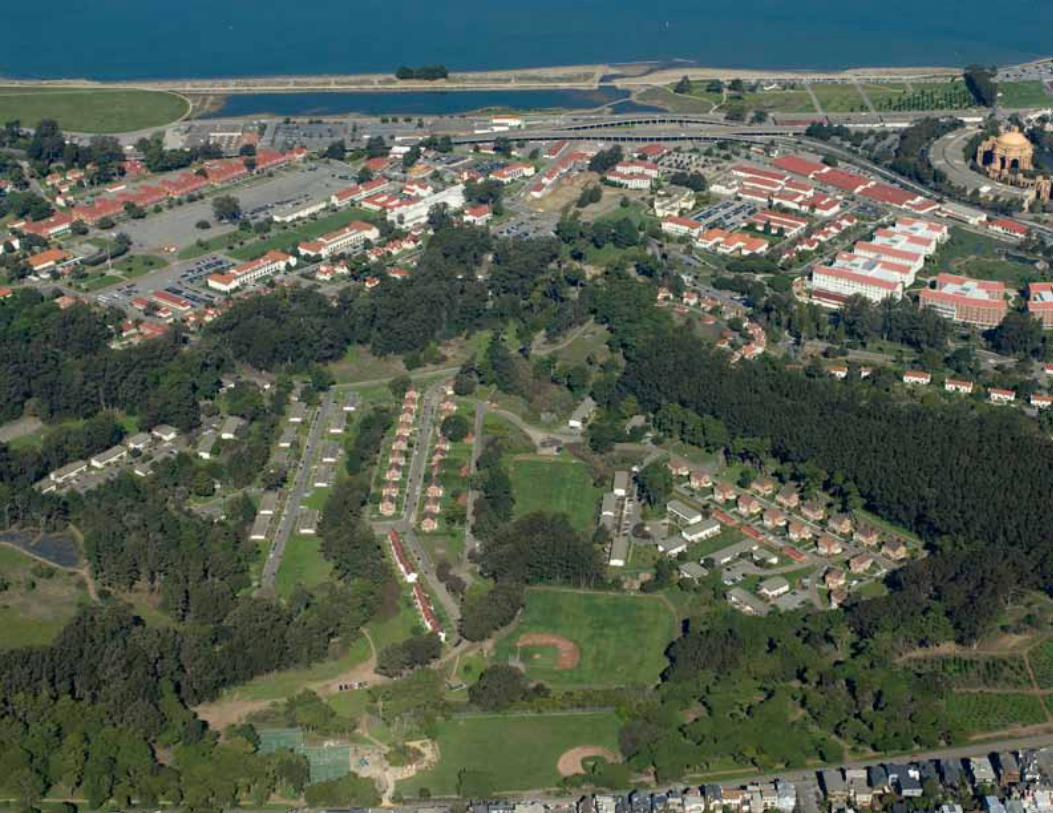


1
West of Main Post Historic Plant Inventory Presidio of San Francisco, Prepared by Michael Lamb, Historic Landscape Architect, The Presidio Trust April 26, 2011 Rec # = Record Number: one number per plant Desig. = Designation: 102-1 means Building 101, The second listed plant species for that building Unkn. # = Unkown plant number (if any) Ht. = Height: (Trees only, dimension in feet) Spread: (Trees only, dimension in feet) Cal. = Caliper:(Trees only, trunk diameter at 5 feet above grade, dimension as noted) Age: Relative for species: A= nascent, B= juvenile, C = mature, D= post mature, in decline, Hist= Historic, likely from before 1945, NA = not applicable Cond. = Condition (Good, fair, poor) Propagation (Method: seeds, division, cuttings, layering, etc.) BUILDING 101
Rec # Desig. Unkn. # Botanical Name Ht. Spread Cal. Age Cond. Propagation Remarks 1 102-1 Hebe sp. cuttings removed for construction 2 102-1 Hebe sp. cuttings removed for construction 3 102-1 Hebe sp. cuttings removed for construction 4 102-1 Hebe sp. cuttings removed for construction 5 101-2 Polystichum munitum division removed for construction
BUILDING 102
Rec # Desig. Unkn. # Botanical Name Ht. Spread Cal. Age Cond. Propagation Remarks 1 102-1 Watsonia beatricis NA seeds, cuttings removed for construction 2 102-2 Rosmarinus sp. C good cuttings
BUILDING 103
Rec # Desig. Unkn. # Botanical Name Ht. Spread Cal. Age Cond. Propagation Remarks 1 103-1 Ligustrum vulgare C good seeds, cuttings 2 103-1 Ligustrum vulgare C good seeds, cuttings 3 103-1 Ligustrum vulgare C good seeds, cuttings 4 103-1 Ligustrum vulgare C good seeds, cuttings 5 103-2 Cupressus macrocarpa 50' 60' 6' C/Hist good seeds ID# XX14

2
BUILDING 104
Rec # Desig. Unkn. # Botanical Name Ht. Spread Cal. Age Cond. Propagation Remarks 1 104-1 Melaleuca quinquenervia C good seeds, cuttings 2 104-1 Melaleuca quinquenervia C good seeds, cuttings 3 104-2 Euonymus fortuunei C good cuttings groundcover
BUILDING 105
Rec # Desig. Unkn. # Botanical Name Ht. Spread Cal. Age Cond. Propagation Remarks 1 105-1 Cordyline australis C poor cuttings 2 105-2 Ligustrum vulgare 'Aurea' C good seeds, cuttings
BUILDING 106
Rec # Desig. Unkn. # Botanical Name Ht. Spread Cal. Age Cond. Propagation Remarks 1 106-1 Syzgium paniculatum C good seeds, cuttings 2 106-1 Syzgium paniculatum C good seeds, cuttings 3 106-1 Syzgium paniculatum C good seeds, cuttings 4 106-2 Cupressus macrocarpa 50' 40' 6 C/Hist poor seeds 5 106-3 Impatiens oliveri NA good cuttings 6 106-3 Impatiens oliveri NA good cuttings 7 106-4 Hydrangea macrophylla C good cuttings 8 106-4 Hydrangea macrophylla C good cuttings 9 106-4 Hydrangea macrophylla C good cuttings
10 106-4 Hydrangea macrophylla C good cuttings 11 106-5 Rhaphiolepis indica C poor cuttings 12 106-6 Ligustrum vulgare C good seeds, cuttings hedge, north side of building 13 106-6 Ligustrum vulgare C good seeds, cuttings hedge, north side of building 14 106-6 Ligustrum vulgare C good seeds, cuttings hedge, north side of building 15 106-6 Ligustrum vulgare C good seeds, cuttings hedge, north side of building 16 106-6 Ligustrum vulgare C good seeds, cuttings hedge, north side of building

3
BUILDING 108
Rec # Desig. Unkn. # Botanical Name Ht. Spread Cal. Age Cond. Propagation Remarks 1 108-1 Leptospermum laevigatum C good cuttings 2 108-1 Leptospermum laevigatum C good cuttings
3 108-2 Euonymus fortuunei 'Colorata'
C good cuttings groundcover
4 108-3 Lantana montevidensis C good cuttings groundcover, lavender flowers
5 108-4 Ulmus parvifolia C good cuttings 6 108-4 Ulmus parvifolia C good cuttings 7 108-4 Ulmus parvifolia C good cuttings
BUILDING 116
Rec # Desig. Unkn. # Botanical Name Ht. Spread Cal. Age Cond. Propagation Remarks 1 116-1 Phoenix canariensis 30' 15' 30" C/Hist good seeds ID# 1835 2 116-1 Phoenix canariensis 30' 15' 3' C/Hist good seeds ID# 1836
BUILDING 122
Rec # Desig. Unkn. # Botanical Name Ht. Spread Cal. Age Cond. Propagation Remarks 1 122-1 Aloe saponaria C good cuttings several 2 122-2 Hebe 'Autum Glory' C good cuttings hedge, several 3 122-3 Leptospermum laevigatum C good cuttings 4 122-3 Leptospermum laevigatum C good cuttings 4 122-4 Lantana montevidensis C good cuttings groundcover, lavender flowers
5 122-5 Euonymus fortuunei 'Colorata'
C good cuttings groundcover

4
BUILDING 123
Rec # Desig. Unkn. # Botanical Name Ht. Spread Cal. Age Cond. Propagation Remarks 1 123-1 Lavandula NA good seeds 2 123-2 Pittosporum undulatum 12' 8' 6" C good seeds, cuttings 3 123-3 Pelargonium domesticum NA good cuttings pink and white flowers 4 123-4 Crassula argentea C good leaf cuttings 5 123-5 Cupressus macrocarpa 60' 36' 5' D/Hist fair seeds ID# 1817
BUILDING 124
Rec # Desig. Unkn. # Botanical Name Ht. Spread Cal. Age Cond. Propagation Remarks 1 124-1 Impatiens oliveri NA good cuttings 2 124-1 Impatiens oliveri NA good cuttings 3 124-1 Impatiens oliveri NA good cuttings 4 124-1 Impatiens oliveri NA good cuttings 5 124-1 Impatiens oliveri NA good cuttings 6 124-2 Sedum sp. NA good cuttings 7 124-3 Crassula argentea NA good leaf cuttings 8 124-4 Aeonium sp. NA good leaf cuttings
9 124-5 Rosmarinus C good cuttings 10 124-6 Chrysanthemum maximum NA good cuttings purple flower 11 124-6 Chrysanthemum maximum NA good cuttings purple flower 12 124-7 Cupressus macrocarpa 50' 60' 3' C good seeds close to structure

5
BUILDING 125
Rec # Desig. Unkn. # Botanical Name Ht. Spread Cal. Age Cond. Propagation Remarks 1 125-1 Zantedeschia aethiopica NA good bulbs, division 2 125-1 Zantedeschia aethiopica NA good bulbs, division 3 125-1 Zantedeschia aethiopica NA good bulbs, division 4 125-2 Kniphofia uvaria NA good bulbs, division 5 125-3 Ligustrum lucidum 8" 5' 6" C good seeds, cuttings 6 125-4 Buxus japonica 4' 4' C good cuttings 7 125-3 Ligustrum lucidum 8" 5' 6" C good seeds, cuttings 8 125-4 Buxus japonica 4' 4' C good cuttings 9 125-3 Ligustrum lucidum 8" 5' 6" C good seeds, cuttings
10 125-5 Persea (avacado) 30' 30' 18" C good cuttings twin trunks, close to structure 11 125-1 Zantedeschia aethiopica NA good bulbs, division 12 125-1 Zantedeschia aethiopica NA good bulbs, division 13 125-6 1 Unknown poor herbaceous exotic 14 125-7 Rosa 'Cecile Brunner' C good cuttings 15 125-7 Rosa 'Cecile Brunner' C good cuttings 16 125-8 Rosa 'Cecile Brunner' C good cuttings 17 125-2 Kniphofia uvaria NA good bulbs, division

6
BUILDING 126
Rec # Desig. Unkn. # Botanical Name Ht. Spread Cal. Age Cond. Propagation Remarks 1 126-1 Rosa 'Cecile Brunner' C good cuttings 2 126-1 Rosa 'Cecile Brunner' C good cuttings 3 126-1 Rosa 'Cecile Brunner' C good cuttings 4 126-2 Syzgium paniculatum C good seeds, cuttings 5 126-3 Salvia leucantha NA poor seeds, cuttings 6 126-4 Rosa C good cuttings red flowers 7 126-5 Tecoma capensis C good cuttings 8 126-1 Rosa 'Cecile Brunner' C good cuttings 9 126-1 Rosa 'Cecile Brunner' C good cuttings
10 126-1 Rosa 'Cecile Brunner' C good cuttings
11 126-6 Fuschia C good cuttings 12 126-1 Rosa 'Cecile Brunner' C poor cuttings
13 126-7 Myrica communis 'Compacta'
C good cuttings
14 126-8 Ligustrum vulgare C/Hist good seeds, cuttings hedge, several plants 15 126-9 Phoenix canariensis 30' 15' 3' C/Hist good seeds ID# 1821 16 126-9 Phoenix canariensis 30' 15' 3' C/Hist good seeds ID# 1822 17 126-9 Phoenix canariensis 15' 15' 3' C/Hist good seeds

7
BUILDING 127
Rec # Desig. Unkn. # Botanical Name Ht. Spread Cal. Age Cond. Propagation Remarks 1 127-1 Zantedeschia aethiopica NA good bulbs, division
2 127-2 Rosmarinus o. 'Tuscan Blue'
C good cuttings
3 127-3 Ligustrum lucidum C good seeds, cuttings 4 127-4 Hydrangea macrophylla C good cuttings 5 127-5 Camelia japonica C good cuttings pink flowers 6 127-6 Rosa 'Cecile Brunner' C good cuttings 7 127-7 Crassula argentea C good cuttings 8 127-8 Lavandula stocheas NA good cuttings 9 127-9 Hybiscus rosa-sinensis C good cuttings
10 127-10 Hardenbergia violacea C good cuttings
BUILDING 128
Rec # Desig. Unkn. # Botanical Name Ht. Spread Cal. Age Cond. Propagation Remarks 1 128-1 Lavandula dentata NA good seeds, cuttings 2 128-2 Leptospermum scoparium 7' 8' 3" C good cuttings 3 128-3 Crassula argentea NA good cuttings 4 128-4 Zantedeschia aethiopica NA good bulbs, division 5 128-5 Fuchsia magellanica NA good cuttings 6 128-6 Dietes bicolor NA good seeds, cuttings 7 128-7 Impatiens oliveri NA good cuttings 8 128-8 Tropaeolum majus C good seeds, cuttings 9 128-9 Camelia japonica C fair cuttings pink flowers
10 128-10 Hydrangea macrophylla C good cuttings 11 128-11 Rosa 'Cecile Brunner' C good cuttings 12 128-12 Amaryllis belladonna NA good bulbs, division
13 128-13 Sempervivum tectorum NA good cuttings

8
BUILDING 129
Rec # Desig. Unkn. # Botanical Name Ht. Spread Cal. Age Cond. Propagation Remarks 1 129-1 Aloe saponaria NA good seeds, cuttings 2 129-2 Crassula argentea C good cuttings 3 129-3 Lavandula stocheas NA good cuttings 4 129-4 Rosa 'Cecile Brunner' C good cuttings 5 129-5 Avocado (Lauraceae) 30' 20' 10" C good seeds, cuttings 2 trunks, close to structure 6 129-6 Zantedeschia aethiopica NA good bulbs, division 7 129-7 Cupressus macrocarpa 60' 55' 7' C/Hist good seeds, cuttings ID# 1822 (verify)
FENCELINE BEHIND BUILDINGS 127, 128, and 129
Rec # Desig. Unkn. # Botanical Name Ht. Spread Cal. Age Cond. Propagation Remarks 1 FL-1 Avocado (Lauraceae) 20' 20' 18" C good seeds, cuttings two trunks 2 FL-2 Ficus elastica 45' 35' 4' C good seeds, cuttings ID# 1826 3 FL-3 Ligustrum 6' 5' C good seeds, cuttings 4 FL-4 Westringia rosmariniformis C poor seeds, cuttings 5 FL-5 Escallonia sp. C poor seeds, cuttings 6 FL-6 Buddleia davidii C fair seeds, cuttings 7 FL-7 Salvia leucantha NA good seeds, cuttings 8 FL-8 Rubus C good seeds, cuttings 9 FL-9 Lupinus C good seeds, cuttings
10 FL-10 Sequoia sempervirens 70' 30' 24" C good seeds, cuttings three trunks 11 FL-11 Rosa C good cuttings pink flowers 12 FL-12 Cupressus macrocarpa 25' 18' 12" B good seeds, cuttings 13 FL-13 Escallonia sp. C good seeds, cuttings hedge, several plants 14 FL-14 Eucalyptus globulus 40" 30' 3' C fair seeds, cuttings poor structure

9
BUILDING 130
Rec # Desig. Unkn. # Botanical Name Ht. Spread Cal. Age Cond. Propagation Remarks 1 130-1 Griselina littoralis 10' 10' C good seeds, cuttings 2 130-1 Griselina littoralis 10' 10' C good seeds, cuttings 3 130-2 Taxus b. 'Stricta' 25' 8' C good seeds, cuttings
4 130-2 Taxus b. 'Stricta' 25' 8' C good seeds, cuttings 5 130-3 Agapanthus orientalis NA good bulbs, division 6 130-4 Westringia rosmariniformis C good seeds, cuttings 7 130-5 Chrysanthemum frutescens NA good cuttings 8 130-6 Rosa good seeds, cuttings 9 130-7 Chlorophytum comosum NA good cuttings
10 130-8 Picea g. 'Conica' 4' 2' good cuttings 11 130-9 Jasminum polyanthum NA good cuttings 12 130-10 Sedum spathulifolium NA good cuttings 13 130-11 Crassula argentea good cuttings 14 130-12 Brahea edulis 14' 10' 12' C/Hist good seeds, cuttings 15 130-12 Brahea edulis 8' 6' 10" C/Hist good seeds, cuttings 16 130-13 Platyycladus orientalis good seeds, cuttings 17 130-14 Xylosma congestum good cuttings 18 130-14 Xylosma congestum good cuttings 19 130-14 Xylosma congestum good cuttings 20 130-14 Xylosma congestum good cuttings 21 130-14 Xylosma congestum good cuttings 22 130-14 Xylosma congestum good cuttings 23 130-15 Cyathea cooperi good cuttings 24 130-16 Phormium sp. good division red leaf, 3 feet tall 25 130-16 Phormium sp. good division red leaf, 3 feet tall

10
BUILDING 130 Memorial Garden
Rec # Desig. Unkn. # Botanical Name Ht. Spread Cal. Age Cond. Propagation Remarks 1 130MG-1 Prunus laurocerasus 8' 8' C good seeds, cuttings 2 130MG1 Prunus laurocerasus 8' 8' C good seeds, cuttings 3 130MG-2 Hydrangea macrophylla B good cuttings 4 130MG-3 Myrsine africana C good cuttings hedge, several plants 5 130MG-4 Hebe sp. NA good cuttings hedge, several plants 6 130MG-5 Platyycladus orientalis C good seeds, cuttings 7 130MG-6 Tibouchina urvilleanna 5' 2' C fair cuttings mixed into hebe hedge 8 130MG-7 Lavandula stocheas NA good cuttings mixed into hebe hedge 9 130MG-8 Pyracantha sp. C good seeds, cuttings mixed into hebe hedge
10 130MG-9 Corylus sp. C good cuttings mixed into hebe hedge 11 130MG-10 Jasminum polyanthum NA good cuttings mixed into hebe hedge 12 130MG-11 Erica sp. C good cuttings mixed into hebe hedge 13 130MG-12 Azalea sp. C good cuttings mixed into hebe hedge 16 130MG-13 Rhododendron sp. C good cuttings mixed into hebe hedge 17 130MG-14 Rosmarinus sp. C good cuttings mixed into hebe hedge 18 130MG-15 Escallonia sp. C good cuttings mixed into hebe hedge 19 130MG-16 Buxus japonica C good cuttings mixed into hebe hedge 20 130MG-17 Azara dentata C good cuttings mixed into hebe hedge 21 130MG-18 Euryops acraeus NA good cuttings mixed into hebe hedge 22 130MG-19 Sequoia sempervirens 5' 2' C good seeds, cuttings mixed into hebe hedge 23 130MG-20 Impatiens NA good cuttings mixed into hebe hedge 24 130MG-21 Agapanthus orientalis NA good bulbs, division mixed into hebe hedge 25 130MG-22 Chlorophytum comosum NA good cuttings mixed into hebe hedge 26 130MG-23 Pelargonium domesticum good cuttings mixed into hebe hedge
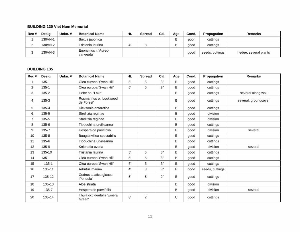
11
BUILDING 130 Viet Nam Memorial
Rec # Desig. Unkn. # Botanical Name Ht. Spread Cal. Age Cond. Propagation Remarks 1 130VN-1 Buxus japonica B poor cuttings 2 130VN-2 Tristania laurina 4' 3' B good cuttings
3 130VN-3 Euonymus j. 'Aureo-variegata'
good seeds, cuttings hedge, several plants
BUILDING 135
Rec # Desig. Unkn. # Botanical Name Ht. Spread Cal. Age Cond. Propagation Remarks 1 135-1 Olea europa 'Swan Hill' 5' 5' 3" B good cuttings 2 135-1 Olea europa 'Swan Hill' 5' 5' 3" B good cuttings 3 135-2 Hebe sp. 'Lake' B good cuttings several along wall
4 135-3 Rosmarinus o. 'Lockwood de Forest'
B good cuttings several, groundcover
5 135-4 Dicksonia antarctica B good cuttings 6 135-5 Strelitzia reginae B good division 7 135-5 Strelitzia reginae B good division 8 135-6 Tibouchina urvilleanna B good cuttings 9 135-7 Hesperaloe parvifolia B good division several
10 135-8 Bougainvillea spectabilis B good cuttings 11 135-6 Tibouchina urvilleanna B good cuttings 12 135-9 Kniphofia uvaria B good division several 13 135-10 Tristania laurina 5' 5' 3" B good cuttings 14 135-1 Olea europa 'Swan Hill' 5' 5' 3" B good cuttings
15 135-1 Olea europa 'Swan Hill' 5' 5' 3" B good cuttings 16 135-11 Arbutus marina 4' 3' 3" B good seeds, cuttings
17 135-12 Cedrus atlatica gluaca 'Pendula' 5' 5' 2" B good cuttings
18 135-13 Aloe striata B good division 19 135-7 Hesperaloe parvifolia B good division several
20 135-14 Thuja occidentalis 'Emeral Green' 8' 2' C good cuttings

12
Rec # Desig. Unkn. # Botanical Name Ht. Spread Cal. Age Cond. Propagation Remarks
21 135-14 Thuja occidentalis 'Emeral Green' 8' 2' C good cuttings
22 135-14 Thuja occidentalis 'Emeral Green' 8' 2' C good cuttings
23 135-14 Thuja occidentalis 'Emeral Green' 8' 2' C good cuttings
24 135-14 Thuja occidentalis 'Emeral Green' 8' 2' C good cuttings
25 135-14 Thuja occidentalis 'Emeral Green' 8' 2' C good cuttings
26 135-15 Trachycarpus fortunei 12' 8' C good cuttings flanking front entry 27 135-15 Trachycarpus fortunei 15' 8' C good cuttings flanking front entry
28 135-14 Thuja occidentalis 'Emeral Green' 8' 2' C good cuttings
29 135-14 Thuja occidentalis 'Emeral Green' 8' 2' C good cuttings
30 135-14 Thuja occidentalis 'Emeral Green' 8' 2' C good cuttings
31 135-14 Thuja occidentalis 'Emeral Green' 8' 2' C good cuttings
32 135-14 Thuja occidentalis 'Emeral Green' 8' 2' C good cuttings
33 135-14 Thuja occidentalis 'Emeral Green' 8' 2' C good cuttings
34 135-2 Hebe sp. 'Lake' B good cuttings several along drive 35 135-15 Canna minerva NA good division several in planter 36 135-16 Heuchera sanguinea NA good division several 37 135-17 Arbutus unedo 6' 6' 4" C good cuttings 38 135-9 Kniphofia uvaria B good division several 39 135-18 Chamaerops humilis B good division 40 135-11 Arbutus marina 4' 3' 3" B good seeds, cuttings 41 135-19 Crataegus phaenopyrum 15' 10' 6" C good seeds, cuttings 42 135-19 Crataegus phaenopyrum 15' 10' 6" C good seeds, cuttings 43 135-19 Crataegus phaenopyrum 15' 10' 6" C good seeds, cuttings 44 135-19 Crataegus phaenopyrum 15' 10' 6" C good seeds, cuttings
13
Rec # Desig. Unkn. # Botanical Name Ht. Spread Cal. Age Cond. Propagation Remarks 45 135-19 Crataegus phaenopyrum 15' 10' 6" C good seeds, cuttings 46 135-19 Crataegus phaenopyrum 15' 10' 6" C good seeds, cuttings 47 135-20 Eucalyptus globulus 60' 40' 10' C/Hist good seeds, cuttings ID# 2430 48 135-20 Eucalyptus globulus 60' 40' 8' C/Hist good seeds, cuttings ID# 2431 49 135-21 Griselina littoralis 10' C good seeds, cuttings 50 135-21 Griselina littoralis 10' C good seeds, cuttings 51 135-21 Griselina littoralis 10' C good seeds, cuttings 52 135-21 Griselina littoralis 10' C good seeds, cuttings 53 135-21 Griselina littoralis 10' C good seeds, cuttings 54 135-21 Griselina littoralis 10' C good seeds, cuttings
55 135-4 Dicksonia antarctica 3' B good cuttings 56 135-22 Cupressus macrocarpa 65' 40' 6' C/Hist good seeds, cuttings ID# 2429 57 135-22 Cupressus macrocarpa 65' 30' 5' C/Hist good seeds, cuttings 58 135-22 Cupressus macrocarpa 55' 20' 3' C/Hist good seeds, cuttings 59 135-22 Cupressus macrocarpa 12' 10' 6" B good seeds, cuttings 60 135-22 Cupressus macrocarpa 65' 30' 6' C/Hist good seeds, cuttings ID#2426 61 135-22 Cupressus macrocarpa 65' 30' 4' C/Hist good seeds, cuttings 2 trunks, ID# 2425 62 135-22 Cupressus macrocarpa 65' 30' 5' C/Hist good seeds, cuttings 63 135-22 Cupressus macrocarpa 65' 30' 5' C/Hist good seeds, cuttings 64 135-22 Cupressus macrocarpa 65' 30' 4' C/Hist good seeds, cuttings 65 135-22 Cupressus macrocarpa 65' 30' 4' C/Hist good seeds, cuttings 66 135-22 Cupressus macrocarpa 65' 30' 4' C/Hist good seeds, cuttings 67 135-23 Pinus radiata 30' 20' 2' C/Hist poor seeds, cuttings covered with ivy