Embed Size (px)
Citation preview

Flood Protection Corridor Program Grant Application
River Ranch Agricultural Conservation and Flood Protection for the Sacramento Region
Yolo County
Submitted by: American Farmland Trust
260 Russell Blvd Ste D Davis CA 95616
Contact:
John McCaull, Regional Director (530) 753-1073 ● [email protected]
FPCP Grant Application: River Ranch Agricultural Conservation and Flood Protection
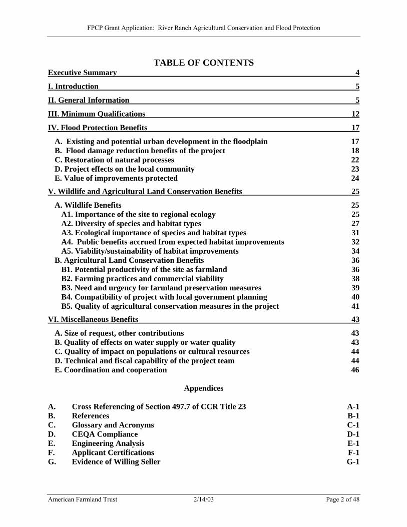
TABLE OF CONTENTS
Executive Summary 4
I. Introduction 5
II. General Information 5
III. Minimum Qualifications 12
IV. Flood Protection Benefits 17
A. Existing and potential urban development in the floodplain 17 B. Flood damage reduction benefits of the project 18 C. Restoration of natural processes 22 D. Project effects on the local community 23 E. Value of improvements protected 24
V. Wildlife and Agricultural Land Conservation Benefits 25
A. Wildlife Benefits 25 A1. Importance of the site to regional ecology 25 A2. Diversity of species and habitat types 27 A3. Ecological importance of species and habitat types 31 A4. Public benefits accrued from expected habitat improvements 32 A5. Viability/sustainability of habitat improvements 34
B. Agricultural Land Conservation Benefits 36 B1. Potential productivity of the site as farmland 36 B2. Farming practices and commercial viability 38 B3. Need and urgency for farmland preservation measures 39 B4. Compatibility of project with local government planning 40 B5. Quality of agricultural conservation measures in the project 41
VI. Miscellaneous Benefits 43
A. Size of request, other contributions 43 B. Quality of effects on water supply or water quality 43 C. Quality of impact on populations or cultural resources 44 D. Technical and fiscal capability of the project team 44 E. Coordination and cooperation 46
Appendices
A. Cross Referencing of Section 497.7 of CCR Title 23 A-1 B. References B-1 C. Glossary and Acronyms C-1 D. CEQA Compliance D-1 E. Engineering Analysis E-1 F. Applicant Certifications F-1 G. Evidence of Willing Seller G-1
American Farmland Trust 2/14/03 Page 2 of 48
FPCP Grant Application: River Ranch Agricultural Conservation and Flood Protection
Tables Table 1: River Ranch Soils 36 Table A-1: River Ranch Costs by Task Appendix A Table A-2: River Ranch Property Owners Appendix A Table A-3: Adjoining Property Owners Appendix A
Figures Figure 1: Vicinity Map 7 Figure 2: Proposed Project Features 8 Figure 3: Floodplain Map 16 Figure 4: Vegetation Types 29 Figure 5: Prime Farmland 36
Photographs Photograph 1: Wetlands 10 Photograph 2: Prime Farmland 10 Photograph 3: Walnut Orchards 11 Photograph 4: Yolo Bypass 11
American Farmland Trust 2/14/03 Page 3 of 48
FPCP Grant Application: River Ranch Agricultural Conservation and Flood Protection
Executive Summary The American Farmland Trust seeks six million dollars ($6,000,000) in funding from the Flood Protection Corridor Program to assist in the purchase of the River Ranch property along the Sacramento River in Yolo County. The River Ranch Project provides a rare opportunity for the Department of Water Resources (DWR) to assist in the permanent protection of nearly 3,700 acres of productive farmland while improving vitally important flood protection throughout the lower Sacramento Valley. In the short term, the project will secure a substantial portion of critically needed transitory flood storage in the upper Elkhorn area of Yolo County. In the long term, the River Ranch project will further a comprehensive program of regional flood control improvements that will significantly reduce floodwater elevations in the Yolo Bypass and the lower Sacramento River. The project contains the following elements:
Agricultural conservation — Under the proposal, the agricultural productivity of the River Ranch site will be conserved in perpetuity by an agricultural conservation easement. Transitory flood storage — The River Ranch site covers about 45 percent of the levee-protected area in upper Elkhorn (along the west side of the Sacramento River north of Interstate 5). The project seeks to preserve the transitory storage capacity of the site by conveyance of a flood protection easement to DWR. This will enhance the short-term prospects for securing the transitory storage capacity of the entire upper Elkhorn area and reducing the risk of flooding developed areas along the Sacramento River, including the rapidly urbanizing Natomas Basin. Regional flood protection — The conveyance of a flood protection easement will be accompanied by the conveyance of rights to the State to enhance the long-term prospects for implementing a comprehensive regional flood protection project aimed at reducing floodwater elevations and minimizing the risk of flooding from the rivers, tributaries, and canals surrounding the Fremont Weir, including the Yolo Bypass and the lower Sacramento River. Stakeholder involvement — The River Ranch project is not only compatible with local and regional planning by agencies and stakeholder groups, but it also meets objectives of CALFED and the Sacramento-San Joaquin River Basin Comprehensive Study.
American Farmland Trust (AFT) is well-qualified to implement this proposal. For over 20 years AFT has been fulfilling our mission of stopping the loss of productive farmland and promoting farming practices that lead to a healthy environment. The River Ranch project will fulfill a recent directive from AFT’s Board to develop place-based examples of “best farming practices” that improve soil health and productivity, increase wildlife habitat and biodiversity and improve water quality. This project will also fulfill our continued goal of expanding and improving the state's efforts to purchase agricultural conservation easements (PACE) in high-priority farming and ranching regions of California.
American Farmland Trust 2/14/03 Page 4 of 48

FPCP Grant Application: River Ranch Agricultural Conservation and Flood Protection
Flood Protection Corridor Program Project Evaluation Criteria
And Competitive Grant Application Form
I. Introduction
The introductory text from the grant application form has not been reproduced here.
II. General Information Project Name: River Ranch
Project Location: The junction of the Sacramento River, the Yolo Bypass, the Sutter Bypass,
the Feather River, and the Natomas Cross Canal. County: Yolo
Name and address of sponsoring agency or non-profit organization:
American Farmland Trust, 260 Russell Blvd Ste D, Davis CA 95616
Name of Project Manager (contact): John McCaull
Phone Number: (530) 753-1073 E-mail Address: [email protected]
Grant Request Amount: $6,000,000
Regional Director Project Manager Title
Date
Project Objective(s): Briefly describe your project and explain how it will advance FPCP goals. Please also include a detailed map of the immediate project site and another that shows its location within your geographical area. Photographs showing problem areas proposed to be enhanced by the project should also be included.
American Farmland Trust 2/14/03 Page 5 of 48
FPCP Grant Application: River Ranch Agricultural Conservation and Flood Protection
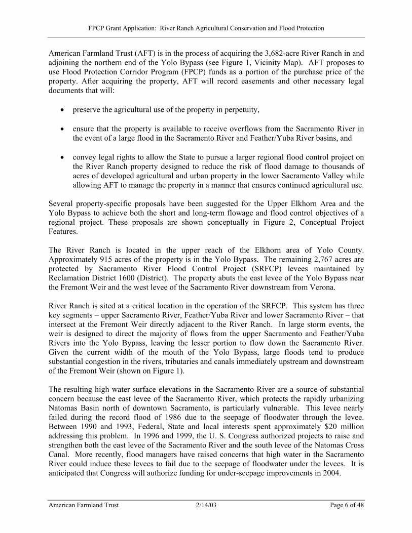
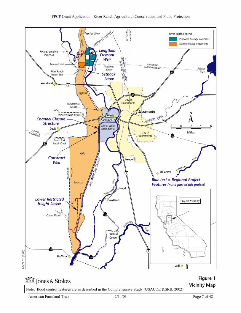
American Farmland Trust (AFT) is in the process of acquiring the 3,682-acre River Ranch in and adjoining the northern end of the Yolo Bypass (see Figure 1, Vicinity Map). AFT proposes to use Flood Protection Corridor Program (FPCP) funds as a portion of the purchase price of the property. After acquiring the property, AFT will record easements and other necessary legal documents that will:
• preserve the agricultural use of the property in perpetuity,
• ensure that the property is available to receive overflows from the Sacramento River in the event of a large flood in the Sacramento River and Feather/Yuba River basins, and
• convey legal rights to allow the State to pursue a larger regional flood control project on
the River Ranch property designed to reduce the risk of flood damage to thousands of acres of developed agricultural and urban property in the lower Sacramento Valley while allowing AFT to manage the property in a manner that ensures continued agricultural use.
Several property-specific proposals have been suggested for the Upper Elkhorn Area and the Yolo Bypass to achieve both the short and long-term flowage and flood control objectives of a regional project. These proposals are shown conceptually in Figure 2, Conceptual Project Features. The River Ranch is located in the upper reach of the Elkhorn area of Yolo County. Approximately 915 acres of the property is in the Yolo Bypass. The remaining 2,767 acres are protected by Sacramento River Flood Control Project (SRFCP) levees maintained by Reclamation District 1600 (District). The property abuts the east levee of the Yolo Bypass near the Fremont Weir and the west levee of the Sacramento River downstream from Verona. River Ranch is sited at a critical location in the operation of the SRFCP. This system has three key segments – upper Sacramento River, Feather/Yuba River and lower Sacramento River – that intersect at the Fremont Weir directly adjacent to the River Ranch. In large storm events, the weir is designed to direct the majority of flows from the upper Sacramento and Feather/Yuba Rivers into the Yolo Bypass, leaving the lesser portion to flow down the Sacramento River. Given the current width of the mouth of the Yolo Bypass, large floods tend to produce substantial congestion in the rivers, tributaries and canals immediately upstream and downstream of the Fremont Weir (shown on Figure 1). The resulting high water surface elevations in the Sacramento River are a source of substantial concern because the east levee of the Sacramento River, which protects the rapidly urbanizing Natomas Basin north of downtown Sacramento, is particularly vulnerable. This levee nearly failed during the record flood of 1986 due to the seepage of floodwater through the levee. Between 1990 and 1993, Federal, State and local interests spent approximately $20 million addressing this problem. In 1996 and 1999, the U. S. Congress authorized projects to raise and strengthen both the east levee of the Sacramento River and the south levee of the Natomas Cross Canal. More recently, flood managers have raised concerns that high water in the Sacramento River could induce these levees to fail due to the seepage of floodwater under the levees. It is anticipated that Congress will authorize funding for under-seepage improvements in 2004.
American Farmland Trust 2/14/03 Page 6 of 48
FPCP Grant Application: River Ranch Agricultural Conservation and Flood Protection
American Farmland Trust 2/14/03 Page 7 of 48
Figure 1: Vicinity Map
Note: flood control features are as described in the Comprehensive Study (USACOE &SRB, 2002).
FPCP Grant Application: River Ranch Agricultural Conservation and Flood Protection
Figure 2: Proposed Project Features
American Farmland Trust 2/14/03 Page 8 of 48
Note: flood control features are as described in the Comprehensive Study (USACOE &SRB, 2002).
FPCP Grant Application: River Ranch Agricultural Conservation and Flood Protection
As this levee strengthening program proceeds, it is appropriate to pursue complementary short-term and long-term measures to ensure that the flood damage reduction benefits of the program are secured. These short-term measures focus on preserving and improving existing conditions along the west side of the Sacramento River, north of Interstate 5. At critical locations in this reach of the river, the west levee is lower than the east levee. Moreover, the protected lands on the west side are agricultural, containing a mixture of row crops and walnut orchards as well as scattered agricultural facilities and a handful of rural residential structures. AFT believes that a balancing of risks and relative costs dictates that Yolo County Elkhorn properties and west levees be managed in a way to ensure that there is no east levee failure in the event of uncontrollable high water in the Sacramento River. The long-term measures focus on lowering water surface elevations in the Yolo Bypass and the Sacramento River by pursuing regional actions in the lower Sacramento and Yuba River basins. These regional actions are outlined in the Sacramento and San Joaquin River Basins California Comprehensive Study (Comprehensive Study) recently released by the U. S. Army Corps of Engineers (Corps) and the California Reclamation Board (USACOE and SRB, 2002). In the lower Sacramento River corridor, the “Regional Project” described by the Comprehensive Study calls for widening the mouth and increasing the conveyance capacity of the Yolo Bypass by lengthening the Fremont Weir, setting back the east levee of the Yolo Bypass upstream and downstream of Interstate 5, constructing a weir and closure structure in the Sacramento Deep Water Ship Channel to permit use of this channel for flood conveyance, and removing or lowering restricted height agricultural levees at the lower end of the Yolo Bypass. These improvements (shown on Figure 1) will relieve the current congestion at the Fremont Weir and lower water surface elevations in all of the adjacent rivers and canals upstream and downstream of the weir, including the lower Sacramento River. The proposed River Ranch project will significantly aid in achieving the objectives of these short-term and long-term measures. AFT is in active negotiations to purchase the River Ranch property, and seeks FPCP funds to assist in this purchase. Concurrent with the purchase, AFT will convey a flood easement covering almost half of the land comprising the upper portion of the Elkhorn area. AFT will also find a suitable holder for an agricultural conservation easement that will be conveyed to dedicate the Ranch to permanent agricultural use. Under the flood protection easement that AFT will grant to the State, the landowner will be obligated to waive any claims for damages resulting from flooding of the property. In addition, the easement will develop a framework for managing the property in a manner that ensures continued agricultural use while conveying legal rights to the State to pursue a larger regional flood control project consistent with the current recommendations of the Comprehensive Study for the project area. The 3,682-acre project site includes 3,044 farmable acres, of which approximately one-third is planted in walnuts and two-thirds in row crops. Photographs 1 through 3 show the site’s agricultural land as well as existing wetlands areas that have enhancement potential. Please refer to Appendix A for a list of the required California Code of Regulations Section 497.7 components with responses and cross-referencing to this application form.
American Farmland Trust 2/14/03 Page 9 of 48
FPCP Grant Application: River Ranch Agricultural Conservation and Flood Protection
Photograph 1: Wetlands on the project site are contiguous with the Fremont Weir State Wildlife Area and the riparian forests of the Sacramento River.
Photograph 2: The project site is predominantly Prime Farmland, much of which is used for row crops such as tomatoes and melons.
American Farmland Trust 2/14/03 Page 10 of 48
FPCP Grant Application: River Ranch Agricultural Conservation and Flood Protection
Photograph 3: The site hosts approximately 1,000 acres of walnut orchards, shown here with a tule-lined irrigation canal in the foreground.
Photograph 4: Portions of the site within the Yolo Bypass are periodically inundated but are in productive row crops the remainder of the year.
American Farmland Trust 2/14/03 Page 11 of 48
FPCP Grant Application: River Ranch Agricultural Conservation and Flood Protection
III. Minimum Qualifications A. The project proposes to use any granted funds for protection, creation, and
enhancement of flood protection corridors [Water Code Section 79037(b)].
Granted funds will be used exclusively to purchase the River Ranch property to enhance the flood protection corridor along the lower Sacramento River and the Yolo Bypass with conveyance of agricultural conservation, transitory flood storage, and flood control facility relocation rights associated with the River Ranch property in the Elkhorn area of Yolo County.
B. A local public agency, a non-profit organization, or a joint venture of local public
agencies, non-profit organizations, or both proposes the project [Water Code Section 79037(a)].
AFT is a private non-profit organization (see Appendix F, Applicant Certifications).
C. The project will use the California Conservation Corps or a community
conservation corps whenever feasible [Water Code Section 79038(b)].
Because the applicant does not propose any physical improvements requiring physical labor at the present time, it is not feasible to use the CCC in the project.
D. If it is proposed to acquire property in fee to protect or enhance flood protection
corridors and floodplains while preserving or enhancing agricultural use, the proponent has considered and documented all practical alternatives to acquisition of fee interest [Water Code Section 79039(a)].
AFT is very experienced in the completion of transactions that use private, state and federal funds for the acquisition of less-than-fee property interests (i.e easements) to protect land for its agricultural viability. After examining the appraisal for the River Ranch, Yolo County zoning and land-use designations, development patterns in the area and the desired uses of the property, we believe that a fee title acquisition is the appropriate means to achieve the objectives of the FPCP. Rather than attempting a complex easement valuation process through this grant, AFT believes that a simple fee title acquisition and voluntary conveyance of easements for flood protection corridor enhancement and agricultural land conservation will best serve the clear public interests for the region articulated in the SRFCP, CALFED and the Comprehensive Study. For more information, please refer to item D-5 in Appendix A.
E. Holders of property interests proposed to be acquired are willing to sell them
[Water Code Section 79040].
American Farmland Trust 2/14/03 Page 12 of 48
FPCP Grant Application: River Ranch Agricultural Conservation and Flood Protection
AFT is in the process of purchasing the River Ranch property from Deseret Farms, a willing seller. AFT is counting on FPCP funds to provide a portion of the purchase price. In exchange for obtaining these funds, AFT will voluntarily convey an agricultural conservation easement to an appropriate easement holder and a flood protection easement to the State that will encumber the property in perpetuity. AFT may choose to sell the remaining fee interest in the land for fair market value to an individual or organization that will be bound by the easements to keep the property in agricultural production. See Appendix G for documentation of a willing seller.
F. If it is proposed to acquire property interests, the proposal describes how a plan will be developed that evaluates and minimizes the impact on adjacent landowners prior to such acquisition and evaluates the impact on the following [Water Code Section 79041]:
►Floodwaters including water surface elevations and flow velocities ►The structural integrity of affected levees ►Diversion facilities ►Customary agricultural husbandry practices ►Timber extraction operations The proposal must also describe maintenance required for a) the acquired property, b) any facilities that are to be constructed or altered.
The primary purpose of the project is to preserve the historic agricultural husbandry practices at the River Ranch property while enhancing the short-term prospects for securing transitory flood storage capacity in the upper Elkhorn area of Yolo County. The project will also enhance the long-term prospects for implementing a regional flood control project that increases the conveyance capacity of the Yolo Bypass. The River Ranch project alone will not accomplish these objectives. Transitory flood storage will be secured only with the cooperation of the remaining landowners in the upper Elkhorn area, and Reclamation District 1600. AFT is working with the Sacramento Area Flood Control Agency (SAFCA) to develop a plan to secure the same agricultural conservation and flood protection rights from these remaining landowners as are being secured from AFT for the River Ranch Property. Proposition 50 may provide a funding vehicle. If funding is available, SAFCA and AFT will seek to augment the acquired land rights with physical improvements that will allow appropriate management of transitory flood storage in the upper Elkhorn area. These improvements could include improving the Short Line Railroad levee across the Elkhorn area north of Interstate 5 so that flood waters will not invade the farmlands of lower Elkhorn; providing an effective means of evacuating flood waters stored in the upper Elkhorn area and elevating residential structures above the maximum elevation of the storage basin. (See Section IV.B. for more detailed discussion).
American Farmland Trust 2/14/03 Page 13 of 48
FPCP Grant Application: River Ranch Agricultural Conservation and Flood Protection
Implementing a long-term regional flood control project that increases the conveyance capacity of the Yolo Bypass will require the cooperation of: Yolo and Solano County landowners in and out of the Bypass; interested flood control, environmental, open space and other stakeholders throughout the lower Sacramento River Valley; and a willing coalition of local, State and federal decision-makers. Although it is clear that benefits may exist for all these parties, it is uncertain how long it may take to assemble these interests, secure authorization and funding for project improvements, and complete construction of these improvements. Substantial interest in a regional solution exists, and important planning and analysis is being done by the SRB, USACOE, and SAFCA. It is not unusual for major flood control projects to span from two to three decades. This delivery schedule underscores the importance of securing transitory storage on a short-term basis. Any future modification or relocation of flood control facilities on the River Ranch site or other sites in the upper Elkhorn area or elsewhere in the lower Sacramento River corridor, whether undertaken to secure transitory flood storage or implement regional flood control improvements, will be subject to the requirements of the California Environmental Quality Act (CEQA) and possibly the National Environmental Policy Act (NEPA). The statutorily required environmental analysis will address the impacts of these actions on adjoining landowners. The following steps have already been taken to involve neighboring landowners and minimize impacts of the contemplated actions:
• An analysis of floodwaters and the effects of the regional project on water elevations, water velocities, levee integrity, and diversion facilities is currently being undertaken by MBK Engineers as part of an evaluation of regional flood control improvements by SAFCA. This evaluation is scheduled for completion in spring 2003.
• The project is consistent with the report A Framework for the Future: Yolo
Bypass Management Strategy (Yolo Bypass Working Group et al., 2001). This report outlines a number of stakeholder concerns regarding land use in the Bypass that are either addressed by the River Ranch project or will be addressed by the related transitory storage or regional flood control improvements.
• The Lower Sacramento River Regional Project, which is the focus of SAFCA’s
evaluation and could result in the modification of flood control facilities on the project site, has been presented at scoping meetings held before the Yolo Bypass Working Group and the Sacramento River Corridor Floodway Planning Forum.
The River Ranch property will remain in agricultural use and in the fee title ownership of AFT or its successors. The conveyance of an agricultural conservation easement will include the preparation of a conservation plan for the property, and the establishment of a stewardship and monitoring fund to ensure compliance with the terms of the easement. Maintenance will remain the owner’s responsibility and will be funded by continued agricultural production. The agricultural conservation easement will spell out in detail
American Farmland Trust 2/14/03 Page 14 of 48
FPCP Grant Application: River Ranch Agricultural Conservation and Flood Protection
allowable uses on the property and the types of customary agricultural husbandry practices that will occur.
G. The project site is located at least partially in one of the following:
1. A Federal Emergency Management Agency (FEMA) Special Flood Hazard Area (SFHA), or
2. An area that will be inundated if the project were completed and an adjacent
FEMA SFHA were inundated, or 3. A FEMA SFHA, which is determined by using the detailed methods identified
in FEMA Publication 37, published in January 1995, titled “Flood Insurance Study Guidelines and Specifications for Study Contractors”, or
4. A floodplain designated by The Reclamation Board under Water Code
Section 8402(f) [Title 23, California Code of Regulations, Division 2, Section 497.5(a)], or a
5. Locally designated Flood Hazard Area, with credible hydrologic data to
support designation of at lease one in 100 annual probability of flood risk. This is applicable to locations without levees, or where existing levees can be set back, breached, or removed. In the latter case, levee setbacks, removal, or breaching to allow inundation of the floodplain should be part of the project.
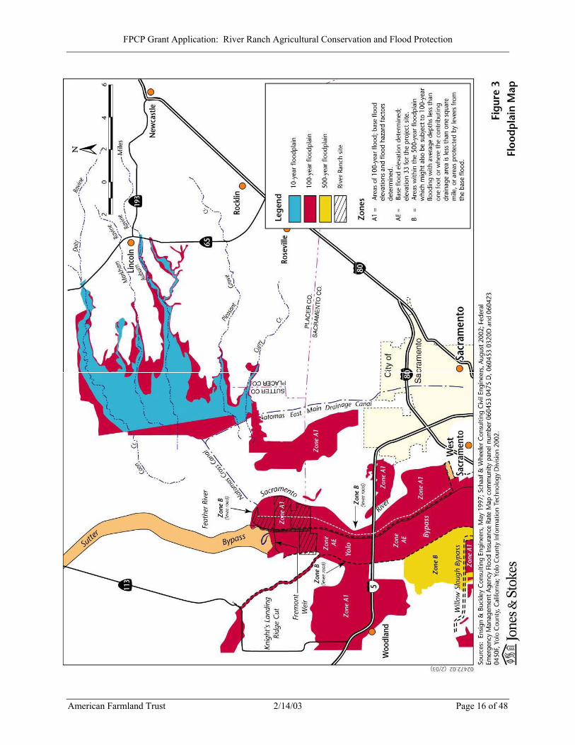
The entire project site is located within a FEMA SFHA, as shown in Figure 3, Floodplain Map, indicating it is subject to a 1% or greater annual risk of flooding. In addition, the 915 acres of the property that are within the Bypass are subject to inundation on average at least one out of every two years and are a “project floodway” adopted by the State Reclamation Board and subject to the requirements of Title 23 of the California Code of Regulations.
American Farmland Trust 2/14/03 Page 15 of 48
FPCP Grant Application: River Ranch Agricultural Conservation and Flood Protection
American Farmland Trust 2/14/03 Page 16 of 48
Figure 3: Floodplain Map
FPCP Grant Application: River Ranch Agricultural Conservation and Flood Protection
IV. (340 points) Flood Protection Benefits A. Existing and potential urban development in the floodplain (50)
1. Describe the existing and potential urban development at the site and the nature of the flood risk.
The River Ranch site currently is in rural agricultural use. It hosts seven dwellings, a shop with ranch office, walnut processing buildings and equipment, a grain storage building and bins, a corn dryer, a scale and scale house, above-ground diesel and fuel tanks, and a large propane tank. Under existing general plan and zoning designations, two more dwellings could be built on the site along with agricultural facilities consistent with the specifics of the zoning code. The potential for additional urban development is subject to change over time. The Elkhorn area is located within 20 miles of downtown Sacramento. The area will likely experience increasing pressure to accommodate rural residential development as the Sacramento region grows. This development could be similar to the development that has occurred along the Garden Highway on the east side of the Sacramento River. Any development along the Sacramento River in Yolo County will create a demand for levee improvements along the west levee that could alter the existing east-west flood risk balance. At critical locations in this reach of the river, the west levee is lower than the east levee. Significant work has been done, and will be done, to strengthen the levee on the east side of the Sacramento River to protect the rapidly growing Natomas Basin. If the west levee is also raised and strengthened in the future, the flood risk for the Natomas Basin could grow dramatically. 2. How often has flooding occurred historically?
The project site is entirely within the floodplain for the 1% annual chance flood event (FEMA, 1998a; FEMA 1998b; FEMA, 2002). The levee-protected area on the project site outside of the Yolo Bypass has flooded once since the Bypass was constructed. The Bypass itself, which includes 915 acres of the project site, has flooded in about 70% of the years from 1935 to present (Yolo Bypass Working Group et. al, 2001; DWR, 2002).
3. Discuss the importance of improving the flood protection at this location.
Include the number of people and structures that are affected by the flood hazard, and the flood impacts to highways and roads, railroads, airports and other infrastructure, and agriculture.
The River Ranch project will enhance both the short-term prospects for securing the transitory flood storage capacity of the upper Elkhorn area and the long-term prospects for increasing the conveyance capacity of the Yolo Bypass as part of a larger regional flood control project. Securing transitory storage will provide immediate relief to the Natomas Basin and other developed areas in the City of Sacramento and the City of West Sacramento by limiting the maximum water surface elevation in the Sacramento River during floods large enough to overtop the west levee near the mouth of the Natomas
American Farmland Trust 2/14/03 Page 17 of 48
FPCP Grant Application: River Ranch Agricultural Conservation and Flood Protection
Cross Canal. Increasing the conveyance capacity of the Yolo Bypass will provide an even greater reduction in flood risk to these same areas by lowering water surface elevations in the Bypass and the Sacramento River and therefore reducing stress on the associated levees. As discussed in Section I, the east levee of the Sacramento River protecting the Natomas Basin is vulnerable to high water surface elevations in the river downstream of the mouth of the Natomas Cross Canal. This levee has been strengthened to resist through-levee seepage. However, levee under-seepage remains a concern. The Natomas Basin currently supports a residential population of 35,224. The estimated value of damageable structures and their contents in the Basin, including Sacramento International Airport, is $3.5 billion (Pingel, pers. comm.; USACOE & SRB, 1996). Natomas is crossed by Interstate 5, Interstate 80, and State Route 99/70. All of these highways will be impassable in the event of a flood from the Sacramento River. Given the Basin’s storage capacity, it could take weeks to evacuate the floodwaters, increasing the direct and indirect damages of the flood. There is also a risk of a Sacramento River flood into developed areas on both sides of the river downstream of the mouth of the American River. As in Natomas, the levees in this reach of the system have been strengthened to resist through-levee seepage. Here too, however, under-seepage triggered by high water surface elevations in the river is a concern. Protected areas on the east side of the river in the City of Sacramento support a residential population of 348,793. The estimated value of damageable structures and their contents in these areas is $29.8 billion. The levee on the west side of the river in the City of West Sacramento protects a residential population of approximately 12,430 and damageable structures and contents with an estimated value of $1.9 billion.
B. Flood damage reduction benefits of the project (100) 1. Does the proposed project provide for transitory storage of floodwaters?
What is the total community need for transitory storage related to this water course and what percentage of the total need does this project satisfy? What is the volume of water and how long is it detained?
The project will acquire a portion of the land necessary for securing the transitory floodwater storage capacity of the upper Elkhorn area of Yolo County. Under current conditions, assuming the levee on the east side of the Sacramento River is further strengthened, it is likely that the first failure point in the system will be along the west levee just downstream from the mouth of the Natomas Cross Canal. This failure will cause water to move into the upper Elkhorn area, controlling the maximum elevation of the water remaining in the river and limiting the pressure exerted against the levees downstream of the failure point. Given its topography and the configuration of its surrounding levees, the upper Elkhorn area north of the Short Line Railroad appears capable of storing approximately 90,000 acre-feet of water (see Appendix E). Once the upper Elkhorn area is filled, there is a risk that the pressure of the stored water against the east levee of the Yolo Bypass could cause
American Farmland Trust 2/14/03 Page 18 of 48
FPCP Grant Application: River Ranch Agricultural Conservation and Flood Protection
this levee to fail, allowing water to spill into the Bypass. Alternatively, the stored water could trigger a failure of the Short Line Railroad levee, allowing water to flow into the lower Elkhorn area. This area is approximately the same size as upper Elkhorn and is assumed to have a comparable storage capacity. However, once lower Elkhorn is inundated, it is uncertain whether the stored water will exit over the east levee of the Yolo Bypass and into the Bypass or fail the north levee of the Sacramento Bypass perhaps creating unwanted pressure against the Sacramento Bypass south levee. Without an agreement and a plan for the use of the Elkhorn area for transitory storage, it is difficult to anticipate what might occur. Reclamation District 1600 could raise the levee as part of its ongoing operations and maintenance program or as part of a vigorous effort in the midst of a storm. In that event, Elkhorn’s transitory storage will not be accessible when it is needed to relieve the pressure on the east-side levee. Even if the storage is accessible, it might create undesirable consequences such as the inundation of lower Elkhorn leading to a failure of the north levee of the Sacramento Bypass as discussed above. This could significantly disrupt the normal operation of the flood control system and result in unforeseen damages. Finally, even if the storage occurs in a predictable manner, the post-flood atmosphere is likely to be acrimonious between cross-river interests, and claims of unfair damage could frustrate post-flood reconstruction efforts. In light of these potential outcomes, it makes sense to secure Elkhorn’s transitory storage in the immediate future through willing landowner agreements and a specific transitory storage management plan supported by such physical improvements as are necessary to carry out the plan. The River Ranch project is a significant first step in this direction. First, this project will ensure that approximately 45 percent of the upper Elkhorn area is permanently dedicated to agriculture, reducing the impetus for expensive perimeter levee improvements and minimizing the extent of the damage that could occur in the event of transitory storage. Second, the project will obligate the landowner to waive any claims for damages due to flooding of the property. Clearly, similar arrangements will be needed with the remaining landowners of the upper Elkhorn area before transitory storage could be properly secured and supported by physical improvements to the existing Elkhorn levee system. However, the River Ranch project will be a powerful first step toward an objective that has not been widely attained in the Central Valley despite the recognized need for a transitory storage. 2. Describe any structural and non-structural flood damage reduction elements
of the project. (Examples of structural elements are levees, weirs, detention/retention basins, rock slope-protection, etc. Examples of non-structural elements are acquisition of property for open space, acquisition of land for flood flow easements, transitory storage, relocation of structures and other flood prone development, elevating flood prone structures, flood proofing structures, etc.)
American Farmland Trust 2/14/03 Page 19 of 48
FPCP Grant Application: River Ranch Agricultural Conservation and Flood Protection
The non-structural elements of the project are described in response to the previous question. As stated, the primary strategy for achieving regional flood control benefits is to acquire the River Ranch property and negotiate flowage and agricultural conservation easements. The River Ranch project does not include any structural flood protection elements. Depending on funding, a later phase of the transitory storage program will focus on acquiring agricultural conservation and transitory flood storage rights over the remaining lands in the upper Elkhorn area similar to those to be obtained in connection with the River Ranch. This later effort could include funding for improvements to the Short Line Railroad levee and the East Levee of the Yolo Bypass that are designed to ensure that transitory storage is confined to the upper Elkhorn area, and that the stored water can be rapidly evacuated at the end of a storm. 3. By what methods and by how much dollar value will the project decrease
expected average annual flood damages? The River Ranch project will contribute to a multi-year effort that will have a substantial economic benefit to the greater Sacramento region effect by reducing the financial exposure from flooding events. The River Ranch project represents an estimated 45% of Upper Elkhorn area that could provide transitory storage needed to protect urban development to the east in the event of a large flood event in the upper Sacramento River and Feather/Yuba River Basins. It will also provide the flood control facility relocation rights that are needed to implement the lower Sacramento River regional project. Acquisition of agricultural conservation and flood protection easements over the remainder of the land in the upper Elkhorn area and implementation of a management plan with supporting physical improvements will secure the area’s transitory storage capacity. This will in turn secure the flood damage reduction benefits of the levee strengthening program in Natomas. Subsequent implementation of the regional project will lower water surface elevations in the Yolo Bypass and lower Sacramento River, further reducing the risk of flooding along the lower Sacramento River corridor. The flood damage reduction benefits associated with these projects have not yet been quantified. However, based on information contained in the Comprehensive Study and earlier documents, it is believed that the cumulative effect of securing transitory storage in the upper Elkhorn area and implementing the regional project will be to reduce expected annual flood damages along the lower Sacramento River corridor by about $25 million (USACOE & SRB, 1996; USACOE & SRB, 2002). 4. How does the project affect the hydrologic and hydraulic conditions at the
project site and adjacent properties? See individual responses to a-c below.
a) Will the project reduce the magnitude of a flood flow, which could cause property damage and/or loss of life?
American Farmland Trust 2/14/03 Page 20 of 48
FPCP Grant Application: River Ranch Agricultural Conservation and Flood Protection
The River Ranch project by itself will not alter the ability to redirect flood flows, but the project will acquire a portion of the land rights necessary to control the magnitude of potentially damaging flood flows in the lower Sacramento River corridor. In the short-term this could be accomplished by securing transitory storage in the upper Elkhorn area. Such storage will allow a portion of the flow produced by a large flood in the upper Sacramento River and Feather/Yuba River basins to be diverted from the lower Sacramento River into the upper Elkhorn area and out to the Yolo Bypass. In the long-term, an even more substantial reduction in flow could be accomplished by altering the flow split at the Fremont Weir so as to increase the percentage of the total volume of water entering the Yolo Bypass and reduce the percentage entering the lower Sacramento River.
b) What are the effects of the project on water surface elevations during a
flood event which could cause property damage and/or loss of life?
The River Ranch project by itself will not create new abilities to alter water surface elevations. However, the project will acquire a portion of the land rights necessary for controlling potentially damaging water surface elevations in the lower Sacramento River corridor. In the short-term this could be accomplished by securing transitory storage in the upper Elkhorn area. Such storage will allow a portion of the flow produced by a large flood in the upper Sacramento River and Feather/Yuba River basins to be diverted from the lower Sacramento River into the upper Elkhorn area for storage and discharge to the Yolo Bypass. This will limit the maximum potential water surface elevation in the lower Sacramento River and reduce the risk of a damaging levee failure in this reach of the system. In the long-term, a substantial reduction in water surface elevation could be accomplished by altering the flow split at the Fremont Weir so as to increase the percentage of the total flow entering the Yolo Bypass and reduce the percentage entering the lower Sacramento River. This will be accomplished by implementing the following measures as part of the lower Sacramento River Regional Project: lengthening the Fremont Weir, setting back the east levee of the Yolo Bypass upstream of the Sacramento Bypass, constructing a weir and closure structure in the Sacramento Deep Water Ship Channel, and removing restricted height agricultural levees at the lower end of the Yolo Bypass. In a major flood, these improvements will reduce water surface elevations in all of the rivers and canals in the vicinity of the Fremont Weir, including a reduction of up to three feet in the lower Sacramento River downstream from the Natomas Cross Canal and lesser reductions in the Yolo Bypass, Sacramento River from the Tisdale weir in the north to Rio Vista in the south, and Feather River as far north as the Marysville/Yuba City region. These reductions will substantially diminish the risk of a damaging levee failure in these reaches of the flood control system. As noted earlier, the flood flow and storage objectives of short- and long-term regional projects could result in a change in flood risks to structures or agriculture in
American Farmland Trust 2/14/03 Page 21 of 48
FPCP Grant Application: River Ranch Agricultural Conservation and Flood Protection
the upper Elkhorn area. AFT will prepare a Flood Management Plan for this project to address such risks and identify solutions.
c) How are flow velocities impacted by the project during a flood flow which
could cause property damage and/or loss of life? The River Ranch project by itself will not affect flow velocities. Flow velocities will be negligibly affected by securing transitory storage in the upper Elkhorn area or by implementing the Lower Sacramento River Regional Project.
C. Restoration of natural processes (60) 1. Describe how any natural channel processes will be restored (for example: for
channel meander, sediment transport, inundation of historic floodplain, etc.) and describe how these natural processes will affect flood management and adjacent properties.
The River Ranch project will not have any physical effect on channel processes. The Lower Sacramento River Regional Project is likely to include a strong environmental restoration component. This component could include measures to extend the Tule Canal along the east side of the Yolo Basin so that it connects directly to the Sacramento River under all flow conditions and provides a permanent passageway for fish connecting the Sacramento River and the Delta. The reconstructed canal could be designed to meander in low flow within a managed riparian corridor. This concept has been identified in the CALFED Environmental Restoration Program and the Comprehensive Study. Its feasibility will be evaluated as part of a larger information report on the Regional Project that is being prepared by SAFCA for issuance in June 2003. The River Ranch Project will support these efforts by precluding development of the site, and providing some restoration opportunities on more marginal farming ground. 2. Describe any upstream or downstream hydraulic or other effects (such as
bank erosion or scour, sediment transport, growth inducement, etc.). The River Ranch project will not have upstream or downstream hydraulic effects. It will affect growth by eliminating the potential for future urban development of the 3,682-acre River Ranch site and thus also deterring urban development of surrounding areas. This area has low immediate growth potential due to agricultural zoning and general plan designations and Williamson Act contracts on the land. The project will acquire land rights necessary in the short term for securing transitory storage in the upper Elkhorn area and in the long term for implementing the Lower Sacramento River Regional Project. If these efforts proceed, they will be subject to a full environmental review, pursuant to the California Environmental Quality Act (CEQA) and the National Environmental Policy Act (NEPA), that would identify all significant physical and growth inducing effects and mitigating them where feasible.
American Farmland Trust 2/14/03 Page 22 of 48

FPCP Grant Application: River Ranch Agricultural Conservation and Flood Protection
3. If the project includes channel modification or bank protection work, will riprap or dredging be part of the design? If so, provide an analysis of potential benefits and impacts.
The River Ranch Project does not include channel modification or bank protection work.
D. Project effects on the local community (60) 1. How will the project impact future flooding on and off this site?
The River Ranch project will not have an immediate, physical effect on flooding at or beyond the project site. It will obtain a portion of the land rights necessary for securing transitory storage in the upper Elkhorn area and for long-term implementation of the Lower Sacramento River Regional Project. As explained above, these efforts will alter the flow of floodwaters through the lower Sacramento River corridor so as to reduce the risk of off-site flooding in developed areas along both sides of the river. AFT is committed to the long-term agricultural productivity of the site, and we seek a flowage easement on the property that is consistent with routine and ongoing agricultural activities. 2. How will the project affect emergency evacuation routes or emergency
services and demands for emergency services?
The River Ranch project will not have an immediate, physical effect on evacuation routes, emergency services, or demand for emergency services. It will prevent growth on the site in perpetuity, which will prevent future increase in demand for evacuation routes or emergency services at the site. The Lower Sacramento River Regional Project, if pursued, will greatly reduce the demand for emergency evacuation routes and emergency services by providing improved flood protection in the area as previously described. 3. Explain how the project will comply with the local community floodplain
management ordinance and the floodplain management criteria specified in the Federal Emergency Management Agency’s National Flood Insurance Program (FEMA’s NFIP).
The River Ranch project will not result in the construction of new facilities in the floodplain and therefore will comply with Title 8, Chapter 3 of the Yolo County Code (Yolo County, 2002), which implements the NFIP, 44 CFR Part 60. The Lower Sacramento River Regional Project, if pursued, could result in the construction, modification, and/or relocation of flood control facilities at the project site. It will be accompanied by engineering analysis and will require a flood hazard development permit from Yolo County, as well as other local, state, and federal permits.
American Farmland Trust 2/14/03 Page 23 of 48
FPCP Grant Application: River Ranch Agricultural Conservation and Flood Protection
E. Value of improvements protected (70) 1. What is the assessed value of structural improvements that will be protected
by the project?
The River Ranch project will not by itself result in protection of structures. However, it will acquire land rights necessary for short- and long- term flood control projects. Based on information contained in the Comprehensive Study, it is believed that the cumulative effect of securing transitory storage in the upper Elkhorn area and implementing the regional project will be to reduce expected annual flood damages along the lower Sacramento River corridor by about $25 million (USACOE & SRB, 1996; USACOE & SRB, 2002). The values of structures protected are provided in the response to question IV(A)(3), above. 2. What is the estimated replacement value of any flood control facilities or
structures protected by the project? The River Ranch Project will not by itself provide flood control facility protection.
The replacement value of levees that would be protected by the regional project has not been estimated here, but would be substantial and far-reaching in geographic scope.
American Farmland Trust 2/14/03 Page 24 of 48
FPCP Grant Application: River Ranch Agricultural Conservation and Flood Protection
V. (340 points) Wildlife and Agricultural Land Conservation Benefits Proponent should provide a statement of the relative importance of the project’s wildlife and agricultural land conservation benefits. DWR will use the statement and all other project materials to assign a fraction of the total benefits to each type (wildlife (Fw) or agricultural land conservation (Fa)) so that the fractions total unity. Actual points scored for each type of resource will be multiplied by the respective fraction for each resource, and the wildlife and agricultural scores resulting for each type of resource will be added together. AFT’s mission is to avoid the loss of productive farmland and to promote farming practices that lead to a healthy environment. Therefore, the primary land conservation objectives for this project are to preserve its productive agricultural use and viability, while also demonstrating how land management techniques can benefit the sensitive environmental conditions of the property, and surrounding areas. Much of the property currently provides nesting, roosting and foraging habitat benefits for the State Threatened Swainson’s hawk and other ground-foraging raptors. The project also provides the opportunity to enhance the habitat value of the Tule Canal. AFT’s objective for land management of the site will be to implement agricultural practices that are both environmentally sound and economically sustainable for long-term crop production. A. (340xFw points) Wildlife Benefits Habitat values refer to the ecological value and significance of the habitat features at this location that presently occur, have occurred historically, or will occur after restoration. Viability refers to the site’s ability, after restoration if necessary, to remain ecologically viable with minimal on-site management over the long-term, and to be able to recover from any natural catastrophic disturbances (fire, floods, etc.).
A1. Importance of the site to regional ecology (70) 1. Describe any habitat linkages, ecotones, corridors, or other buffer
zones within or adjacent to the site. How are these affected by the project?
The project site is adjacent to the Sacramento River corridor, which has a narrow strip of riparian habitat between the river levees. The project site contains approximately 11,500 linear feet of this habitat along the west bank of the Sacramento River. The project will help protect this habitat from degradation. The site also has approximately 15,000 feet of property boundary in common with the Fremont Weir State Wildlife Area, which is well developed with freshwater marsh and riparian vegetation. The Sacramento River corridor adjoining the project site is an important nesting area for the State Threatened Swainson’s hawk (Buteo swainsoni) (CNDDB,
American Farmland Trust 2/14/03 Page 25 of 48
FPCP Grant Application: River Ranch Agricultural Conservation and Flood Protection
2002). The Swainson’s hawk nests in mature trees and forages for rodents in agricultural row crops. As such, the project provides the essential ecotone for this species between riparian nesting habitat and agricultural foraging habitat. Approximately 3,500 feet of the Tule Canal (called the Toe Drain south of I-80) extends through the project site from the Fremont Weir State Wildlife Area and provides an aquatic connection to the Sacramento River at the southern end of the Yolo Bypass. During periods of flow in the Yolo Bypass, which occur on average more frequently than once every two years, the Tule Canal and Yolo Bypass provide important and high quality habitat for fifteen native fish species. These include the federally and State Threatened delta smelt (Hypomesus transpacificus), Federally Threatened steelhead trout (Oncorhyncus mykiss), Federally and State Endangered winter-run chinook salmon (Oncorhynchus tshawytscha), and Federally Threatened splittail (Pogonichthys macrolepidotus) (Sommer et al., 2001). When inundated, the Yolo Bypass through the project site also provides important habitat for migratory waterfowl on the Pacific Flyway. The project will protect these existing habitat linkages and corridors. It will preserve the opportunity for future enhancement on- and off- site pursuant to restoration objectives of a variety of programs, including the CALFED Ecosystem Restoration Program, the Yolo Bypass Management Strategy, and other programs that will be consistent with the terms and objectives of the agricultural conservation easement for the Ranch. 2. Is the site adjacent to any existing conservation areas?
The project site adjoins the Fremont Weir State Wildlife Area. 3. Describe any plans for aquatic restoration resulting in in-stream
benefits. The project provides an opportunity for aquatic restoration along the Tule Canal, consistent with the CALFED Ecosystem Restoration Program and the Yolo Bypass Management Strategy. 4. Discuss any natural landscapes within the site that support
representative examples of important, landscape-scale ecological functions (flooding, fire, sand transport, sediment trapping, etc.)?
Riparian and wetland habitats present within the site carry out a number of vital landscape-scale ecological functions. Riparian habitat plays an important role in stormwater damage prevention, sediment trapping, groundwater recharge, and pollution prevention because the habitat areas are able to process large fluxes of energy and materials from upstream systems. Riparian areas slow high energy flood waters. As the water passes over riparian vegetation, silt generated by erosive stormwater is also deposited. Riparian landscapes on site reduce the
American Farmland Trust 2/14/03 Page 26 of 48
FPCP Grant Application: River Ranch Agricultural Conservation and Flood Protection
erosive effects of floodwaters on the west bank of the Sacramento River and on the east and west levees of the Bypass. When flows recede in the Bypass, riparian vegetation protects the banks of the Tule Canal from erosion and reduces sedimentation from adjoining farmland. Sediments carried along within the stream system are trapped as floodwaters move across the landscape, thereby reducing the amount of silt in downstream waters. Additionally, riparian vegetation aids the protection of groundwater. Streamside flora acts as a natural filter by absorbing excess nutrients and other pollutants before they percolate into the groundwater table. Groundwater recharge occurs as runoff and precipitation slowly infiltrates and percolates through the un-compacted, pervious soils common to riparian areas. Finally, the shade and litter created by riparian canopies provide a cooling effect on stream waters and create excellent fisheries habitat. Despite its agricultural use, the land within the Bypass also functions as a floodplain and performs many of the same ecosystem services described above for riparian habitat. Freshwater marsh wetlands are present along open water canals throughout the project site. These wetlands function similarly to riparian habitat. They filter nutrients, pollutants and sediments draining from agricultural lands and assist in groundwater recharge. As a broad seasonal floodplain, the Yolo Bypass provides important shallow water spawning and rearing habitat for native fish species that are becoming rare with increased flow regulation and channel modification in rivers. In particular, the Yolo Bypass provides key spawning habitat for the Federally Threatened splittail. The habitat value of the Bypass for fish spawning and rearing is comparable to more natural river systems like the Cosumnes River (Sommer et al., 2001). The Bypass also provides key rearing habitat for young chinook salmon, including the Federal and State Endangered winter run. Riparian zones such as those on the site provide better habitat than in the parallel stretch of the Sacramento River (Sommer et al., 2001).
A2. Diversity of species and habitat types (70) 1. Does the site possess any:
i. areas of unique ecological and/or biological diversity?
While most of the River Ranch site is in active agricultural production, unique ecological and biological diversity is present on and adjacent to the site. The western portion of the site is located in the Yolo Bypass, which provides outstanding habitat for waterfowl and shorebirds during winter and spring months when portions of the Bypass are flooded. This portion of the site is expected to be heavily used by waterfowl including ducks, geese, and swans when water conditions are optimal. The Bypass serves as important habitat for migratory shorebirds during the spring and fall migration periods. The Bypass also supports over 40 different species of fish (Sommer et al, 2001). The riparian habitat along the Sacramento River, which forms portions of the
American Farmland Trust 2/14/03 Page 27 of 48
FPCP Grant Application: River Ranch Agricultural Conservation and Flood Protection
northern and eastern boundaries of the site, supports high botanical and wildlife diversity. Great Valley Mixed Riparian Forest, which is found along the Sacramento River near the northern boundary of the site, is considered a sensitive natural plant community in California.
ii. vegetative complexity either horizontally or vertically?
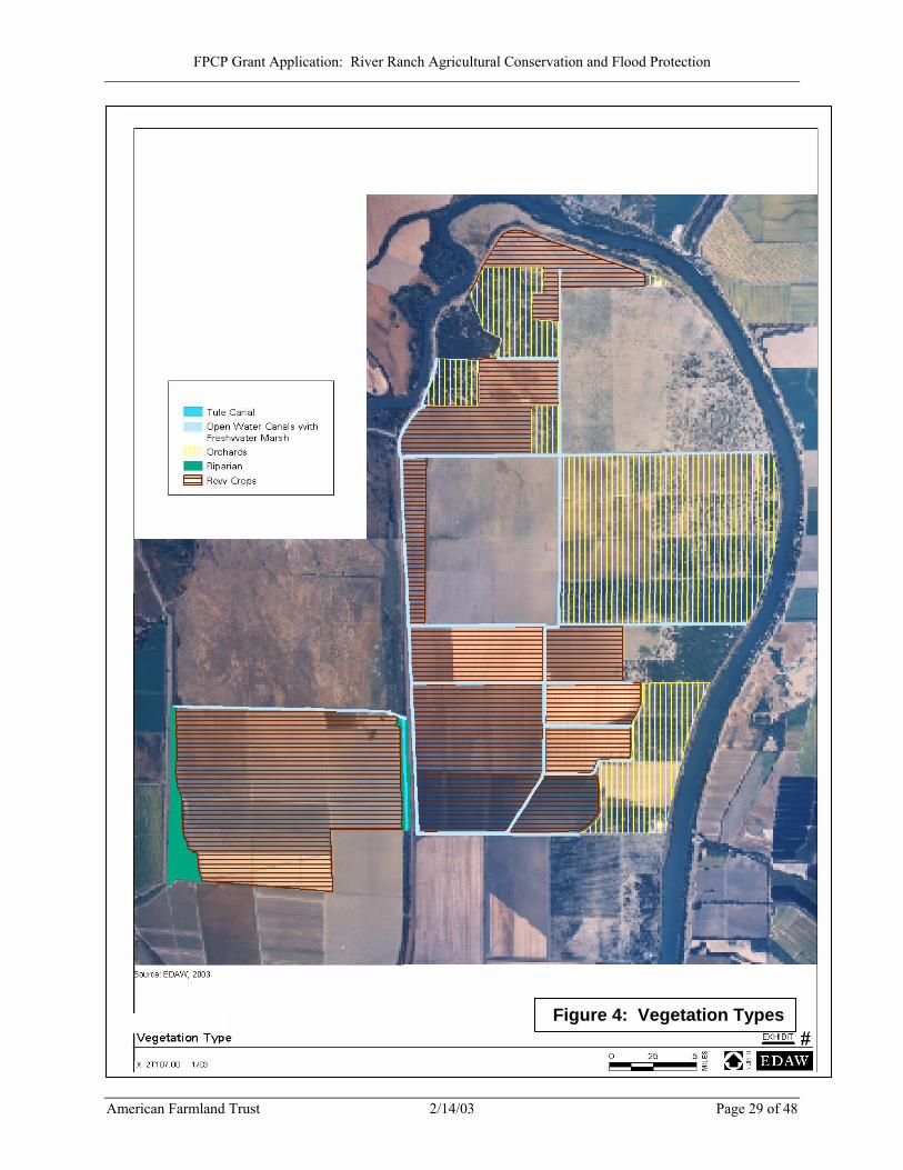
The River Ranch site includes freshwater emergent marsh, willow scrub and riparian habitat, as shown in Figure 4 (Vegetation Types). Tule Canal is located along the east side of the Bypass. The canal supports freshwater emergent marsh and scattered willows and cottonwoods. In a few locations, the marsh habitat intergrades with smaller patches of riparian habitat. Outside of the Bypass area, monotypic agricultural crops cover most of the site. However, a number of small drainage canals that cross the site support freshwater marsh vegetation, frequently mixed with herbaceous weeds. Riparian woodland that provides important wildlife habitat is located along the southern bank of the Sacramento River, which borders portions on the northern and eastern sections of the site. The riparian woodland along the Sacramento River is mostly mature and includes high structural complexity. It varies from a sparse to medium dense canopy of valley oaks (Quercus lobata) with scattered black walnuts (Juglans hindsii), Oregon ash (Fraxinus latifolia), and cottonwoods (Populus fremontii). The understory consists of native shrubs such as California rose (Rosa californica), mulefat (Baccharis salicifolia), blue elderberry (Sambucus mexicana), and grasses and sedges.
2. Describe habitat components including year-round availability of water,
adequate nesting/denning areas, food sources, etc. The Sacramento River and most of the drainage canals within the agricultural area contain water year-round and may provide suitable habitat for the giant garter snake (Thamnophis couchi gigas). Tule Canal, located in the Bypass, is perennial and supports a variety of fish species. The Bypass provides an important food source, breeding, and wintering area for a variety of waterfowl, shorebirds, raptors, songbirds, and other wildlife. Hawks and other raptors also forage in the agricultural areas surrounding the Bypass. The Bypass provides key spawning, rearing, and foraging habitat for splittail (Pogonichthys macrolepidotus) and chinook salmon (Oncorhynchus tsawytscha) (Sommer et al, 2001). 3. Describe any superior representative examples of specific species or
habitats. Although the drainage canals on the site are subject to periodic maintenance (i.e. mowing and sediment removal), they provide habitat for a number of wildlife species, including some sensitive species. A burrowing owl (Athene cunicularia), a California Species of Special Concern, was observed during a field
American Farmland Trust 2/14/03 Page 28 of 48
FPCP Grant Application: River Ranch Agricultural Conservation and Flood Protection
Figure 4: Vegetation Types
Figure 4: Vegetation Types
American Farmland Trust 2/14/03 Page 29 of 48
FPCP Grant Application: River Ranch Agricultural Conservation and Flood Protection
reconnaissance survey conducted on December 19, 2002. The California Natural Diversity Database (CNDDB) (CDFG, 2002) does not include any occurrences of burrowing owl or any other special-status species in the project area. However, several special-status species have been recorded within a three mile radius of the project area. Thirteen occurrences of giant garter snake (Federal Threatened, State Threatened) and more than 20 occurrences of Swainson’s hawk (Buteo swainsoni) (State Threatened) have been recorded in the vicinity of the site. Agricultural fields on the site provide Swainson’s hawk foraging habitat, and the structurally complex Great Valley Mixed Riparian Forest along the northeastern edge of the site provides potential nesting habitat. The canals provide potential year-round habitat for giant garter snake that could be significantly improved through implementation of appropriate restoration measures. 4. Does the site contain a high number of species and habitat types? List
and describe.
Wildlife diversity, particularly waterfowl diversity, can be remarkably high in the Bypass when water conditions are appropriate. In January 1978, CDFG and USFWS recorded 845,000 ducks, geese, and swans in the Bypass. Twenty-one species of hawks and owls potentially occur in the vicinity (Jones & Stokes, 1993), and over 40 species of fish (including 15 natives) have been observed in the Yolo Bypass (Sommer et al., 2001). The remainder of the site consists primarily of agricultural land which supports low to moderate wildlife diversity. Emergent marsh habitat and riparian habitat are also found in the project area; these habitats can support high wildlife diversity but because their distribution on the site is restricted to relatively small areas, wildlife diversity in these areas is expected to be only moderate at this time. However, these areas could serve as important habitat for a number of wildlife species with “wildlife friendly” maintenance and farming practices.
5. Does the site contain populations of native species that exhibit
important subspecies or genetic varieties historically present prior to European immigration?
The Central Valley breeding population of Swainson=s hawks which uses the site is not described as a separate subspecies or genetic variation (England et al. 1997). However, migratory patterns, overwintering areas, and relative isolation of breeding grounds suggest the Central Valley may support a distinct metapopulation with relatively limited interaction with other populations (Woodbridge 1998). Recent unpublished studies have demonstrated that the primary wintering area of individuals that breed in the Central Valley is different from that of other populations (Bradbury 1999). Satellite tracking of individual Swainson=s hawks in the late 1990s demonstrated that the majority of the Central Valley breeding population winters in Mexico, with smaller numbers in Central and South America (Bradbury 1999). The primary wintering region for other Swainson=s hawks is in Argentina (England et al. 1997).
American Farmland Trust 2/14/03 Page 30 of 48
FPCP Grant Application: River Ranch Agricultural Conservation and Flood Protection
A3. Ecological importance of species and habitat types (100) 1. Discuss the significance of habitat types at this location and include
any local, regional, or statewide benefits received by preserving or improving the area.
The River Ranch site provides habitat of statewide importance for the Federal and State-listed giant garter snake (Threatened), the state-listed Swainson’s hawk (Threatened), and wintering waterfowl. The vicinity of the site has some of the highest densities of nesting Swainson’s hawk and giant garter snake occurrences in California with over 20 Swainson’s hawk nesting occurrences and 13 giant garter snake occurrences listed in the CNDDB. The Yolo Bypass is a nationally important area for waterfowl and can support significant populations of native waterfowl species such as northern pintail (Anas acuta), tundra swan (Cygnus columbianus), and American widgeon (Anas americana). 2. Does the site contain any significant wintering, breeding, or nesting
areas? Does it fall within any established migratory corridors? What is the level of significance? How are these affected by the project?
The site contains significant wintering, breeding and nesting areas. The site is within the Pacific Flyway, and a large number of migratory waterfowl and shorebirds use the area during winter. The majority of the wetlands within the Central Valley have been lost, and waterfowl have now become further dependent on agricultural lands for forage and nesting cover. Waste grain is an important food source for these birds during the fall and winter as the fields are flooded after harvest. Many duck species use the Yolo Basin area during spring and summer for nesting and breeding. According to the Suitability Analysis for Enhancing Wildlife in the Yolo Basin, studies have shown that the Bypass can produce anywhere between 600 and 3,600 ducks annually (Jones and Stokes, 1993). Migratory and overwintering wading birds are often found foraging in agricultural fields as well as in the canals and open water areas. Riparian and wetland communities within the site also provide some breeding habitat for wading birds such as herons and egrets. Riparian areas onsite also provides breeding and perching habitat for many species of raptors, including Swainson’s hawk. These areas are especially important on the project site because of the proximity of abundant row crops (on and off site) for foraging raptors. These features will be protected by the project. Opportunities will exist through administration of the agricultural conservation easement and site management plan for implementation of habitat friendly farming practices and specific restoration actions. See also the above discussion (in response to question A1(4)) regarding the importance of landscape-scale flooding in the Yolo Bypass to native fish spawning and rearing.
American Farmland Trust 2/14/03 Page 31 of 48
FPCP Grant Application: River Ranch Agricultural Conservation and Flood Protection
3. Describe any existing habitats that support any sensitive, rare, “keystone” or declining species with known highly restricted distributions in the region or state. Does the site contain any designated critical habitat? How are these affected by the project?
The Sacramento River supports blue elderberry, the host plant for the Federally Endangered valley elderberry longhorn beetle (Desmocerus californicus dimorphus). The western pond turtle (Clemmys marmorata)is known to occur at Conaway Ranch, which is located in the Yolo Bypass approximately 10 miles south of the River Ranch site. Additionally, American white pelican (Pelecanus erythrorhyrnchos), black-shouldered kite (Elanus caeruleus), northern harrier (Circus cyaneus), sharp-shinned hawk (Accipiter striatus), Cooper’s hawk (Accipiter cooperii), peregrine falcon (Falco peregrinus), burrowing owl, greater sandhill crane (Grus canadensis tabida), long-billed curlew (Numenius americanus), and willow flycatcher (Empidonax traillii) are all known to occur in the Bypass or in the site vicinity along the Sacramento River. As previously mentioned, the vicinity of the site has some of the highest densities of nesting Swainson’s hawk and giant garter snake occurrences in the state with over 20 Swainson’s hawk nesting occurrences and 13 giant garter snake occurrences listed in the CNDDB. No critical habitat has been identified in the project area.
4. What is the amount of shaded riverine aquatic (SRA) and riparian
habitat to be developed, restored, or preserved? SRA habitat occurs on three sides of the project site. The Sacramento River is adjacent to the project site along the north and east sides and the Yolo Bypass is located on the west side of the project site. The Sacramento River supports SRA along the waterside of the levee and within the Yolo Bypass, the SRA is located on both sides of Tule Canal. Within the project boundaries, approximately 6,500 linear feet of SRA will be preserved and potentially enhanced. Directly adjacent to the project, 8700 linear feet of SRA occurs along the Tule Canal and 12,682 linear feet of SRA occur along the Sacramento River on the waterside of the levee. The total amount of riparian habitat within or directly adjacent to the project area exceeds 63 acres.
A4. Public benefits accrued from expected habitat improvements (60) 1. Describe present public use/access, if any. For instance, does or will
the public have access for the purpose of wildlife viewing, hunting, fishing, photography, picnics, etc.
The project site is privately owned, and any public use will have to be approved by the landowner, and not interfere with agricultural uses. The site adjoins the publicly owned Fremont Weir State Wildlife Area, which is used for hunting by special permit. It is crossed by public roads (County Roads 16 and 117) and also adjoins the Sacramento River, which is widely used for recreational boating. It
American Farmland Trust 2/14/03 Page 32 of 48
FPCP Grant Application: River Ranch Agricultural Conservation and Flood Protection
will preserve habitats and wildlife that will be available for passive viewing from these publicly accessible areas.
2. Discuss areas on the site that are critical for successfully implementing landscape or regional conservation plans. How will the project help to successfully implement the plans?
The River Ranch site is located near the confluence of the Sacramento and Feather rivers. It also contains a portion of the Yolo Bypass and is directly adjacent to the Fremont Weir. A California Department of Fish and Game wildlife area is located directly adjacent to the property. The Yolo Bypass contains a rich assemblage of habitat types. The Vic Fazio Wildlife Area is located in the Bypass south of I-80, and contains16,000 acres of land managed by CDFG to benefit wintering waterfowl. An additional 12,000 acres, mostly south of I-80, are managed as duck club areas. The Conaway Ranch consists of over 4,000 acres of rice and fallow fields that are managed to attract waterfowl. Outside of the Bypass, the Natomas Basin HCP covers approximately 54,000 acres to preserve habitat, allow economic growth, and to facilitate continued agricultural activities. As the region develops, protection of the River Ranch through establishment of flood and agricultural easements may provide a critical future link to other natural and agricultural areas, particularly those sites that can provide buffer zones to sensitive habitat areas. The River Ranch site is strategically located between the Yolo Bypass and Sacramento River.
Yolo County and its cities have formed a Joint Powers Agency to develop a Habitat Conservation Plan (HCP) and Natural Communities Conservation Plan (NCCP). The Yolo County Habitat/NCCP Joint Powers Agency collects impact fees on new urban development to fund habitat acquisition for the State threatened Swainson’s hawk and other species. Projects consisting of habitat enhancement, agriculture, or flood protection are exempt from the fee. However, because the site is within ½ mile of several Swainson’s hawk nests, it is considered to have habitat potential that will be protected by this project, thus helping in the implementation of the forthcoming HCP/NCCP.
3. Describe the surrounding vicinity. Include the presence or absence of large urban areas, rapidly developing areas, and adjacent disturbed areas with non-native vegetation and other anthropogenic features. Do any surrounding areas detract from habitat values on the site?
The surrounding vicinity west of the Sacramento River is in agricultural orchards and row crops like the site itself. There are associated agricultural structures and rural residences in this area. The Yolo Bypass north and south of the site provides contiguous seasonal aquatic habitat.
East of the project site, on the east side of the Sacramento River, are rural estate residences, including docks and other water recreation oriented features. To the
American Farmland Trust 2/14/03 Page 33 of 48
FPCP Grant Application: River Ranch Agricultural Conservation and Flood Protection
east of the Sacramento River east levee is the rapidly urbanizing North Natomas area and the Sacramento Metropolitan Airport. The Sacramento River provides a natural buffer for development to the east.
4. Describe compatibility with adjacent land uses. The site is compatible with adjacent land uses, which are generally of the same type. The project will not change the site’s agricultural land uses and therefore will remain compatible with adjacent land uses.
A5. Viability/sustainability of habitat improvements (40) 1. Describe any future operation, maintenance and monitoring activities
planned for the site. How will these activities affect habitat values?
The project will ensure the continued private ownership and agricultural operation of the site through conveyance of an agricultural conservation easement to an appropriate entity. The agricultural conservation easement will be self-financing by way of a stewardship and monitoring agreement funded by the potential sale of the property and/or the proceeds of continued agricultural production. AFT will also develop a management plan for the property that ensures the maintenance and enhancement of habitat values at the site.
2. Does the site contain large areas of native vegetation or is it adjacent to large protected natural areas or other natural landscapes (for example, a large stand of blue-oak woodland adjacent to public land)?
The site contains over 63 acres of native riparian habitats. This includes Great Valley Mixed Riparian Forest along the Sacramento River, which is used by the boating public. In addition, as noted in response to question V(A)(1) above, these habitats are contiguous with similar habitat upstream and downstream from the site on the Sacramento River and Yolo Bypass, including the Fremont Weir State Wildlife Area.
3. Is the watershed upstream of the site relatively undisturbed or
undeveloped and likely to remain so into the foreseeable future? Describe its condition.
The majority of the 27,000 square-mile Sacramento River watershed is upstream of the site, and contains the gamut of land uses, including agriculture, urban development, and forest/natural area management. Urban and rural development makes up a relatively small percentage of the total land use but will continue to expand into areas now in agriculture or forest land.
4. Describe any populations of native species or stands of native habitats
that show representative environmental settings, such as soil,
American Farmland Trust 2/14/03 Page 34 of 48
FPCP Grant Application: River Ranch Agricultural Conservation and Flood Protection
elevations, geographic extremes, or climatic conditions (for example, the wettest or most northerly location of a species within the state.)
The Yolo Bypass is one of the richest, most diverse geographic features in the Central Valley. It serves as the floodplain for the Sacramento River and as such has important and representative native plant communities (particularly riparian and wetland), rich depositional soil, and natural processes (flooding regime). A portion of the subject property is within the Yolo Bypass, and the remainder provides a link between the valuable habitat areas of the Sacramento River and the Yolo Bypass. Though the site and the Bypass are intensively managed, the floodplain processes acting within this area provide equivalent function and value for native species to the floodplain of an unregulated river, especially for splittail, chinook salmon, and migratory waterfowl. The project would conserve these representative settings and processes in perpetuity.
American Farmland Trust 2/14/03 Page 35 of 48

FPCP Grant Application: River Ranch Agricultural Conservation and Flood Protection
B. (340xFa points) Agricultural Land Conservation Benefits B1. Potential productivity of the site as farmland (120)
1. Describe the quality of the agricultural land based on land capability, farmland mapping and monitoring program definitions, productivity indices, and other soil, climate and vegetative factors.
The project site is predominantly classified by the California Department of Conservation (CDC) as Prime Farmland, as shown in Figure 5 (Prime Farmland) (CDC, 2002). Soils on the project site are listed in Table 2, which shows that all of the soils have the capability of prime soils except where limited by land use practices. Soils within the Yolo Bypass are considered “flooded” and are classified as Unique Farmland by the CDC, indicating potential to produce high value crops despite occasional seasonal flooding.
Figure 5: Prime Farmland
Table 1: River Ranch Soils
Class Soil
Storie Index
Lang sandy loam 65 Lang sandy loam, deep 58 Sacramento silty clay loam 65 Sacramento clay 38 Sycamore silt loam 76 Sycamore complex 51-64 Sycamore silty clay loam 65 Tyndall very fine sandy loam
77
Prime
Tyndall very fine sandy loam, deep
69
Merritt complex, saline-alkali
27-34 Important
Sycamore complex, flooded 26-32 Sacramento soils, flooded 30 Sycamore silt loam, flooded 45
Unique
Tyndall very fine sandy loam, flooded
38
Source: SCS, 1972; CDC, 2002
Figure 5: Prime Farmland
2. Are projected agricultural practices compatible with water availability?
The project site is presently in agricultural use with a total of up to 13,410 acre-feet of surface water available under five separate water licenses that apply to the project site and some adjoining land (Yurosek, 2001). In addition, there are six deep wells at the site (Yurosek, 2001). Most crops in most years require less than 4 acre feet of water per acre irrigated (Kuminoff et. al, 2000), meaning that total demand at the site will be less than 12,000 acre feet in most years. The available water is more than adequate for the intended use.
American Farmland Trust 2/14/03 Page 36 of 48
FPCP Grant Application: River Ranch Agricultural Conservation and Flood Protection
3. Does the site come with riparian, mineral, and/or development rights?
Fee ownership of the site presently includes riparian water rights and mineral rights. On certain parcels, the mineral rights are reserved in half interest or whole interest. Except where reserved to others, these rights will continue to run with the land. In no case will the mineral or water rights be conveyed to the state. Development rights will be voluntarily conveyed and extinguished by AFT to an appropriate agricultural easement holder.
4. Is the site large enough to sustain future commercial agricultural
production?
The site currently contains over 3,000 acres of land in agriculture. By rule of thumb, approximately 200-acre parcels are necessary for commercial agriculture of non-specialty crops. The site is more than adequate for continued commercial production.
5. Does the site contain any adverse or beneficial deed restrictions
affecting agricultural land conservation?
There are no deed restrictions that will impair AFT’s goal of agricultural land conservation for the Ranch.
6. Describe the present type of agricultural use including the level of
production in relation to the site’s productivity potential. What is the condition of the existing infrastructure that supports agriculture uses?
The site is currently used for approximately 1,000 acres of walnut production and 2,000 acres of row crops. Walnut production on site has a 5-year average yield of 1.1 tons/acre (Yurosek, 2001). This is slightly below the Yolo County 1997-2001 average of 1.3 tons/acre (Yolo County, 1998-2002) but still economically productive. Average US demand is about 0.5 pounds of walnuts per person per year (USDA, 2002), so the site can meet the walnut demand of over 4.5 million people. Data for row crop production on site is not available but is assumed to be comparable to other production in Yolo County. Row crops grown on the site in the past include tomatoes, corn, safflower, melons, and beans. Yolo County reports that county-wide 2001 yields for processing tomatoes were about 35.4 tons per acre (Yolo County 2001), meaning that the site could produce about 70,800 tons of tomatoes. Based on U.S. Department of Agriculture figures, this is enough to meet the annual demand of over 2 million people (USDA, 2003). Existing infrastructure for agriculture is excellent. A network of earthen canals distributes irrigation water from the six wells and six river pumps that are on-site. A shop and ranch office are on site, as are a 70-foot scale, scale house and above-
American Farmland Trust 2/14/03 Page 37 of 48
FPCP Grant Application: River Ranch Agricultural Conservation and Flood Protection
ground diesel, fuel and propane tanks. Leased walnut facilities installed on site include a huller, float tank, conveyer system, dryer unit, holding bin, and main dryer with four 25-ton bins. A leased grain system installed on site includes two dump pits, two continuous flow crib dryers, a 500-ton storage capacity building, two 11-ton bins with dryer fans, and a complete auger and elevator system (Yurosek, 2001). Durable infrastructure is in good repair. Earthen irrigation and drainage features are in good condition but will require periodic maintenance with agricultural tractors as is typical for these features.
B2. Farming practices and commercial viability (40) 1. Does the area possess necessary market infrastructure and
agricultural support services? The site is approximately five miles by paved road from Interstate 5, with ready access to Woodland (eight miles) and Sacramento (10 miles). Yolo County supports a $300,000,000 annual agricultural industry with all necessary support services (Yolo County, 2001). 2. Are surrounding parcels compatible with commercial agricultural
production?
Surrounding parcels are in commercial agricultural production and are entirely compatible with commercial agricultural use of the site.
3. Is there local government economic support in place for agricultural
enterprises including water policies, public education, marketing support, and consumer and recreational incentives?
Local government support for agricultural enterprises includes a strong right-to-farm ordinance (see B4(3)), and a recently-adopted Agriculture Element of the County General Plan that identifies goals encouraging establishment of conservation easements and perpetual agricultural use of Prime soils (Yolo County, 2002b).
4. Describe any present or planned future environmentally friendly
farm practices (no till, erosion control, wetlands avoidance, eco-friendly chemicals, recycling wastes, water conservation, biological pest control).
AFT is committed to environmentally responsible and sustainable farming practices, and we will prepare a site management and conservation plan that will accompany our conveyance of the agricultural conservation easement. As our Board has indicated, AFT is interested in developing “best management practices” that are suited to the site, and that improve soil health and productivity,
American Farmland Trust 2/14/03 Page 38 of 48

FPCP Grant Application: River Ranch Agricultural Conservation and Flood Protection
increase wildlife habitat and biodiversity and improve water quality. Practices will be developed consistent with cropping patterns, soil types and drainage, adjacency to habitat areas and suitability for lands subject to flooding.
B3. Need and urgency for farmland preservation measures (70)
1. Is the project site under a Williamson Act contract? The project site is under Williamson Act Contract (Nordstrom, pers. comm.). It is worth noting that Governor Davis has proposed elimination of all Williamson Act subvention payments in Fiscal Year 2003-2004, and ultimately the permanent repeal of the subvention payment program. This proposal creates a new set of uncertainties of how Yolo County will choose to honor Williamson Act contracts in the future. 2. Describe the surrounding vicinity. Include the presence or absence of
large urban areas, rapidly developing areas, low density ranchette communities, and adjacent disturbed areas with non-native vegetation and other human-induced features. Do any surrounding areas detract from agricultural values on the site?
East of the site on the opposite bank of the Sacramento River is the rapidly growing North Natomas area and the Sacramento Airport. Directly across the River are very large estate homes on the water side of the levee. The river and the adjoining banks and levees buffer the site from any incompatibility with these land uses. The City of Woodland is six miles southwest. The vicinity of the project site west of the Sacramento River is rural agriculture, and is compatible with agriculture at the site. 3. What types of conversion or development are likely on neighboring
parcels? What are the land uses of nearby parcels? Describe the effects, if any, of this project to neighboring farming operations or other neighboring land uses.
Conversion of neighboring parcels from agriculture is not imminent due to the agricultural zoning and General Plan designations in the area and the agricultural or open space use of all abutting parcels. Likewise, the project, by perpetuating the existing land use at the site, will not have adverse effects on the agricultural use of adjoining properties. 4. Describe the relationship between the project site and any applicable
sphere of influence.
The project is outside the sphere of influence of any nearby urban areas.
American Farmland Trust 2/14/03 Page 39 of 48
FPCP Grant Application: River Ranch Agricultural Conservation and Flood Protection
5. Is the agricultural land use on the project site consistent with the local General Plan? Does the General Plan demonstrate commitment to long-term agricultural conservation?
The site is currently in agricultural use and is designated for agricultural use in the General Plan. The General Plan Agricultural Element for Yolo County was just revised (Yolo County, 2002b) and includes strong protections for agriculture, including polices aimed at encouraging the establishment of agricultural conservation easements and continued agricultural use of Prime soils. This project would help implement the General Plan policies.
B4. Compatibility of project with local government planning (50)
1. Is the agricultural land use on the project site consistent with the local General Plan? Does the General Plan demonstrate commitment to long-term agricultural conservation?
See response to B3(5), above. 2. What is the present zoning and is the parcel developable?
The current zoning of the project site is Agricultural Preserve (A-P). This zoning district restricts development to agricultural facilities and no more than 1 dwelling per parcel, with a minimum 80-acre parcel size (Yolo County, 2002). The site, which currently has seven dwellings, could be developed with two more dwellings plus any number of agricultural structures consistent with the zoning code.
3. Is there an effective right to farm ordinance in place?
Title 10, Chapter 6 of the Yolo County Code is a right to farm ordinance adopted in 1992 (Yolo County, 2002c). It specifies in part that no agricultural activity that has existed for more than three years (such as the agricultural uses at the River Ranch site) shall be considered a nuisance due to any changed conditions in the locality.
4. Is the project description consistent with the policies of the Local
Agency Formation Commission?
The project will not involve an annexation or any other activity under the purview of the Local Agency Formation Commission.
5. Will the project as proposed impact the present tax base?
AFT would be eligible for the state’s welfare tax exemption for lands owned and managed for conservation purposes. However, in order to support the local economy, we would elect to pay property taxes as long as we own the land.
American Farmland Trust 2/14/03 Page 40 of 48
FPCP Grant Application: River Ranch Agricultural Conservation and Flood Protection
B5. Quality of agricultural conservation measures in the project (50)
1. For agriculture lands proposed for conservation, describe any additional site features to be conserved that meet multiple natural resource conservation objectives, including wetland protection, wildlife habitat conservation, and scenic open space preservation where the conservation of each additional site feature does not restrict potential farming activities on the agriculture portions of the site.
The project would conserve wetlands, riparian zones and floodplain processes. It would preserve or increase row crops used by foraging raptors. The preserved riparian zones along the Sacramento River provide scenic beauty for the recreating public on the Sacramento River. These topics are discussed in detail in Section V(A); please refer to that section for more information. 2. What are the present biological/ecological values to wildlife? How are
these values affected by the proposed project?
The site provides high quality habitat for native fish spawning and rearing, nesting habitat for raptors, and habitat for waterfowl on the Pacific Flyway, among other values. These values would be preserved or enhanced in perpetuity by the project. The biological and ecological values of the site are presented in detail in section V(A) of this application; please refer to that section for more information. 3. Is the project proponent working with any local agricultural
conservancies or trusts? AFT is an established, highly regarded nationwide agricultural trust with strong local roots and a regional headquarters located in Davis, California within 20 miles of the River Ranch site. Formed in 1980 by a group of concerned farmers and with more than 50,000 members and 90 staff nationwide, AFT is highly capable of managing this project. AFT ranks California’s Central Valley as the most threatened farming region in the nation and has a California regional office committed to the preservation of farmland in the state. AFT has a close working relationship with the Yolo Land Trust, and we are actively seeking their participation as a partner in this project. 4. Does conservation of this site support long-term private stewardship of
agricultural land? How does this proposal demonstrate an innovative approach to agricultural land conservation?
This project will support long term private stewardship of the agricultural land by keeping the fee-title ownership of the property in private hands, and the land in
American Farmland Trust 2/14/03 Page 41 of 48
FPCP Grant Application: River Ranch Agricultural Conservation and Flood Protection
active production. AFT is in the process of securing purchase rights for the property, pending approval of grant funds to reimburse our purchase costs. Once the easements have been conveyed and the land is protected, AFT may elect to sell the property to a private owner who will manage the property for its agricultural production value. The new owner will be obligated by the easements to keep the land in agricultural production. Although conservation easements are no longer a new tool for the preservation of agricultural land and production, this approach is still innovative for the Yolo Bypass region. The Yolo Bypass is a 59,000-acre area of which 18,000 acres are currently in state ownership and 12,300 acres are under study for a federal wildlife refuge (Yolo Bypass Working Group, 2001; Kashing, 2002). Conservation easements in the Bypass are generally habitat-oriented. This project, while having the potential to improve wildlife habitat in the Bypass, will focus on preserving the agricultural value represented by the Prime Farmland at the project site.
5. Without conservation, is the land proposed for protection likely to be
converted to non-agricultural use in the foreseeable future?
The project site is currently in agricultural production, zoned for agriculture, and under a Williamson Act contract. These factors, combined with Yolo County’s support for agriculture, mean that there is no imminent threat of development of the site. However, it is immediately across the Sacramento River from the rapidly developing North Natomas region of Sacramento. In the long term, these growth pressures will be felt in Yolo County. The site is within the farming region that AFT ranks nationally as the area most threatened by urban development. California is projected to more than double its 1990 population to nearly 60 million inhabitants by the year 2040 (DOF, 1998). These factors cannot help but influence the long term viability of agriculture at the site if it is not permanently protected for agricultural use as proposed in this grant application. Urban development on widened levees is being pursued elsewhere in the Delta. Even if the low portions of the site were not developed, if this type of development were approved it could result in the construction of over 375 homes in the Elkhorn area without addressing flooding issues.
American Farmland Trust 2/14/03 Page 42 of 48
FPCP Grant Application: River Ranch Agricultural Conservation and Flood Protection
VI. (320 points) Miscellaneous Benefits and Quality of Proposal A. Size of request, other contributions, number of persons benefiting, cost of grant per benefited person (40)
Estimated Total Project Cost $11,150,000_ Amount of FPCP Grant Funds Requested _$6,000,000_ Amount of Local Funds Contributed $3,000,000†_
† Funding will be provided by AFT and recouped upon either the securing and award of additional grant funds or the sale of the land at fair market value to a qualified buyer.
Amount of In-kind Contributions $2,150,000_ Completed pre-project planning $50,000 Grant Administration $300,000 Long-Term Maintenance $1,800,000
Additional Funding Sources AFT has qualified for a $9,000,000 loan from the Program Related Investment Fund of the David and Lucile Packard Foundation to buy this property. Other potential funders include the California Farmland Conservancy Program, the Federal Farm and Ranch Land Protection Program, the Wildlife Conservation Board, the Yolo County NCCP/HCP, and State Proposition 50 bond funds.
Number of persons expected to benefit Flood Protection portion—see grant section IV(A) 396,000 Agricultural production—see grant section IV(B) 3,000,000+ Flood Protection Corridor Funds per person benefited.* $1.76 (* Count as beneficiaries those receiving flood benefits, recreational users
of habitat areas protected by the Project, and consumers of food products from agricultural areas conserved by the Project.)
B. Quality of effects on water supply or water quality (90) 1. Will water stored by the project provide for any conjunctive use,
groundwater recharge, or water supply benefit? The project will not store water for future water supply. It is hoped that the opportunity exists to improve agricultural management of the site to conserve water for other beneficial uses. This is currently being studied by AFT. 2. Does the project fence cattle out?
American Farmland Trust 2/14/03 Page 43 of 48
FPCP Grant Application: River Ranch Agricultural Conservation and Flood Protection
The site as Prime Farmland has a higher and better use than for grazing. It is not currently grazed, and it is not likely to be grazed under the project. There is no current need to fence cattle out.
3. Does the project pass water over newly developed fresh water marsh? The project will not result in physical or operational changes. It will create an opportunity for compatibility with other restoration activities in the Yolo Bypass such as are proposed by the CALFED Ecosystem Restoration Program.
4. Does the project trap sediments? The project will have negligible impact on water velocity and sediment settling. It supports the continued or expanded use of the Yolo Bypass, which reduces sediment entrainment in floodwaters.
C. Quality of impact on underrepresented populations or historic or cultural resources (60)
1. Does the project benefit underrepresented populations? Explain.
The project will not benefit underrepresented populations. 2. Are historical or cultural resources impacted by the project? Explain.
A cultural resources record search was conducted for the project site (NWIC, 2002). Two Native American cultural resources are known to occur on the site, and others may occur due to the proximity of the Sacramento River. The River Ranch project will not result in new impacts to historical and cultural resources. It will result in continued agricultural production in areas already consisting of regularly disturbed land. The regional project, if pursued, could result in modifications to historic levees or disturbance of soil in areas not previously excavated. Prior to authorization, the regional project will undergo full environmental review and mitigation will be proposed for any impacts of this type.
D. Technical and fiscal capability of the project team (60) 1. Does the project require scientific or technical expertise, and if so, is it
provided for in the grant proposal? The project will require expertise in drafting the conservation easements and completing the land transactions. AFT is the national expert on agricultural conservation easements, and will work with the State Reclamation Board, Department of Water Resources, California Department of Conservation, Natural Resources Conservation Service, California Department of Fish and Game and
American Farmland Trust 2/14/03 Page 44 of 48
FPCP Grant Application: River Ranch Agricultural Conservation and Flood Protection
AFT’s attorneys regarding the necessary specific provisions of the agricultural and flowage easements. We will also work with Reclamation District 1600, SAFCA and other parties to develop flood management plans for the property. 2. Grant funds will be available in phases. What monitoring and reporting
mechanisms are built into your administrative plan to track progress, initiation, and completion of successive phases?
The project as proposed is intended to be completed in one phase within one year of grant award or AFT’s closing escrow on the subject property, whichever is later. In compliance with the FPCP (Title 23, California Code of Regulations, Sections 497.3), it is understood that 10% of the funds will be withheld from grant disbursements until the project is complete and a maintenance plan submitted. The River Ranch project will be complete once the specified flood easements have been conveyed to the State, and the agricultural conservation easement conveyed to an appropriate organization. Those easements will establish the rights and obligations for ongoing property maintenance. More information on project timing is provided in Appendix A.
3. Please outline your team’s management, fiscal and technical capability
to effectively carry out your proposal. Mention any previous or ongoing grant management experience you have.
AFT is a national organization with an annual budget of over $12 million. We have in-house expertise to manage grants of any size, and a team of staff that can negotiate and implement all the conditions required by the easements contemplated with this project. Key staff in the initial phase of this project include: John McCaull is the California Regional Director for the American Farmland Trust (AFT). In this capacity, John manages a staff of six in California, and is responsible for raising the organization’s budget and providing overall program direction.. After 10 years as the California Legislative Director for the National Audubon Society, John accepted the position with AFT in August 2001 to pursue a personal and professional goal of building stronger and more lasting relationships between the environmental and agricultural communities. John is an attorney with a strong background in environmental law, public policy advocacy and project management. Simon Sidamon-Eristoff has been General Counsel to American Farmland Trust since 1998. He is responsible for all of the nonprofit organization’s legal affairs, including land conservation transactions, tax and estate planning matters, legislative analysis, and nonprofit corporate governance. A nationally recognized expert in the land conservation field, he has worked for nonprofit organizations, government agencies, and private landowners in connection with a wide variety of conservation, real estate and tax matters in more than 16 years of private and public law practice. His experience in conservation includes 8 years’ work as an
American Farmland Trust 2/14/03 Page 45 of 48
FPCP Grant Application: River Ranch Agricultural Conservation and Flood Protection
in-house attorney at two other national nonprofit organizations, the Trust for Public Land and the Rails to Trails Conservancy.
Pat Ewing is AFT’s Director of Land Projects. She began working for AFT in October 2001 as a consultant to assist with closing easement transactions by the end of the year, and became full-time in April 2002. Prior to joining AFT, Ewing was general counsel for a privately held $1 billion multi-national corporation, and before that, served as general counsel to World Wildlife Fund, where she worked for seven years. In addition, she practiced with the law firm of Howrey, Simon, Arnold & White for six years. She served on the board of a local land trust in Maryland, founded a nonprofit advocacy organization dedicated to impacting land use in southern Maryland, and has been actively involved in land use issues for many years.
AFT may bring in consultants or partner with other organizations on an as-needed basis to deal with some of the technical aspects of this project.
E. Coordination and cooperation with other projects, partner agencies, and affected organizations and individuals (80)
1. List cost sharing and in-kind partners and any other stakeholders involved with your project and indicate the nature of their contribution, if any. Address the team’s ability to leverage outside funds.
AFT is very capable of leveraging outside funds for this project. We have qualified for a $9,000,000 loan from the Program Related Investment Fund of the David and Lucile Packard Foundation to buy this property. Other potential funders include the California Farmland Conservancy Program, the Federal Farm and Ranch Land Protection Program, the Wildlife Conservation Board, the Yolo County NCCP/HCP, and State Proposition 50 bond funds. In addition, in-kind contributions by AFT and our partners will comprise more than $2,000,000 as described in Section VI(A). 2. Does your project overlap with or complement ongoing activities being
carried out by others (such as CALFED, the Sacramento and San Joaquin River Basins Comprehensive Study, the Delta levee program, local floodplain management programs, the Reclamation Board’s Designated Floodway program, or a multiple objective regional or watershed plan)? If so, indicate any coordination that has taken place to date or is scheduled to take place in the future.
The project is consistent with CALFED’s Ecosystem Restoration Program (ERP). Specifically, the rights the State will acquire in the Yolo Bypass will facilitate the setback of levees, and, if pursued, the modification of the Fremont weir complex for fish passage.
American Farmland Trust 2/14/03 Page 46 of 48
FPCP Grant Application: River Ranch Agricultural Conservation and Flood Protection
The project complements the Sacramento and San Joaquin River Basins Comprehensive Study. The Lower Sacramento River Regional Project (regional project) is described in the Comprehensive Study. The rights that this grant will enable AFT to convey to the State will support the implementation of the regional project. The project site is partly in a Reclamation Board Designated Floodway and will be consistent with floodway management. The project is consistent with the Preliminary Draft Yolo County Habitat Conservation Plan (EIP and Yolo County HCP Steering Committee, 2001), which establishes goals for protecting biologically significant blocks of land while maintaining their agricultural productivity. The project is consistent with the recently-adopted Yolo County General Plan Agricultural Element, including policies AP-3, which encourages acquisition of agricultural conservation easements, and AP-13, which encourages conservation and farming use of prime soils (Yolo County, 2002b). It will be presented to the Yolo County Board of Supervisors, which will be given a chance to approve the project prior to acceptance of a grant award. The project is consistent with the Yolo Bypass Management Strategy. The Lower Sacramento River Regional Project to which the project will contribute was presented to the Yolo Bypass Working Group on November 20, 2002. The regional project is consistent with the objectives of the Sacramento River Corridor Floodway Planning Forum and was presented to the Forum on November 25, 2002.
3. Will this application, if approved, begin the next phase of a previously
approved project or advance an ongoing project substantially toward completion?
This project stands on its own merits for the protection of agriculture in Yolo County, and is actually the first phase of a new project for AFT and our partners. The application coincides with the locally-sponsored study of the Lower Sacramento River Regional Project, which is due to be completed in Spring 2003. If that project is pursued, the project will benefit it by eliminating the need for any additional acquisition of flood facility rights on the project site.
4. Describe how the proposal demonstrates a coordinated approach
among affected landowners, local governments, and nonprofit organizations. If other entities are affected, is there written support for the proposal and a willingness to cooperate?
American Farmland Trust 2/14/03 Page 47 of 48

FPCP Grant Application: River Ranch Agricultural Conservation and Flood Protection
American Farmland Trust 2/14/03 Page 48 of 48
The proposal attempts to coordinate the concerns of the Yolo Bypass Working Group, CALFED, SAFCA, DWR, SRB, Yolo County, City of Sacramento, County of Sacramento, and AFT. As noted above, it will provide benefits to agriculture, the environment, and flood protection. AFT is committed to securing consensus and broad-based support for the management of this property. This project represents a unique opportunity to create a solution to regional problems that benefits all affected parties, and we will strive to demonstrate this support in the coming months through written letters of support to DWR.
Thank you for taking the time and effort to fill out this application. Please send one hard copy with required signatures by 3:00 p.m. on February 14th, 2003 to: Earl Nelson, Program Manager Flood Protection Corridor Program Division of Flood Management 1416 9th Street, Room 1641 Sacramento, CA 95814 Please also send an electronic copy by 3:00 p.m. on February 14th, 2003 to: Bonnie Ross at [email protected]