Embed Size (px)
Citation preview
Flood Protection Corridor Program Project Evaluation Criteria
And Competitive Grant Application Form
I. Introduction
The Coastal San Luis Resource Conservation District is requesting $500,000 under the Flood Protection Corridor Program (FPCP) of the Costa Machado Water Act of 2000 (Proposition 13) from the Department of Water Resources. These funds will be used to pursue the FPCP goals of providing for the protection, creation, and enhancement of a flood protection corridor on Los Osos Creek, San Luis Obispo County, through the following actions:
Acquiring easements and other interests in real property from willing sellers to protect or enhance flood protection corridors and floodplains while preserving or enhancing the agricultural use of the real property.
Acquiring interests in real property from willing sellers located in a floodplain that can not reasonably be made safe from future flooding.
II. General InformationProject Name: Los Osos Wetland Reserve Enhancement
Project Location: Los Osos Creek, Morro Bay Watershed, San Luis Obispo County
Name and address of sponsoring agency: Coastal San Luis Resource Conservation District 545 Main Street, Suite B-1 Morro Bay, CA 93430
Name of Project Manager: Malcolm McEwen
Phone Number: (805) 772-4391 E-mail Address: [email protected]
Grant Request Amount: $500,000
_______________________________
Neil Havlik, CSLRCD Board President
_______________________________
Date
Page 1
Project Objective(s): .
Background. Morro Bay and its watershed lands are some of the most beautiful and treasured landscapes of the State. From the broad vistas of dunes and tidelands that bring many to Montaña de Oro State Park to the line of rugged hills of the Morros between Morro Bay and San Luis Obispo, the immediate area of Morro Bay is a magnet for tourism. The environmental quality remains high, but will require very strong efforts in its defense. Much of the area has been farmed for generations, but is threatened by increasing urban development and the quality and quantity of local water supplies. Morro Bay and its watershed lands are also considered to be one of the most sensitive ecosystems in California. The immediate area is considered to have the highest biological diversity in a county that is itself ranked 21st of all counties in the nation in risks to its species richness. The Bay is a critical link on the Pacific Flyway, is nearly always within the top ten sites in the nation for Christmas Bird Count, and is ranked first in the nation in Audubon Society’s “Big Sit” survey. The surrounding lands are home to many rare species, with a very high species diversity compared to other coastal wetlands in central and southern California. The existing high environmental and scenic quality of the area is an economic benefit to tourism, coastal fisheries, and farming operations.
The waters of Morro Bay are a critical nursery for marine species, but are at potential risk from both pollution and sedimentation. Both of the principal streams into Morro Bay, Chorro and Los Osos Creeks, are functioning steelhead habitat and support red-legged frog. Morro Bay, recognized as a ‘State Estuary’, has been included in the National Estuary Program, a watershed consortium of stakeholders, because of the Bay’s high value and because of the immediate need for a sustaining conservation strategy. The State of California’s application to the National Estuary Program for Morro Bay states :
“The Morro Bay Estuary contains the most significant system on California’s south central coast. It serves as a critical environmental function on the Pacific Coast and serves international interests in that it supports many species of migratory birds protected by international treaties and provides a protected harbor for offshore marine fisheries. Sediment threatens to shorten the life of this open water resource by as much as tenfold.”
In 1987 the RCD obtained funding through the California State Coastal Conservancy (SCC) to quantify the historical loss of open water in the bay, and to locate and quantify sediment sources to the bay in order to create a baseline for future reference. The results of the study indicated that the bay had been filling in at a rate ten times greater during the last one hundred years than it had previously. The results also showed that the bay has decreased in volume by 25 percent in the last century. The major source of the sediment is the brushlands in Chorro and Los Osos Valleys.
Using these studies as a baseline the RCD then hired the USDA Soil Conservation Service (now known as the Natural Resources Conservation Service) to develop the Morro Bay Watershed Enhancement Plan. The recommended plan detailed three phases of action. Phase I was land treatment. Phase II was a sediment trap on Los Osos Creek. Phase III was a sediment trap on Chorro Creek.
Page 2
The “passive” sediment trap on Chorro Creek (i.e., no mechanical removal) was developed as the Chorro Flats Enhancement Project. Almost 200,000 cubic yards of material have been deposited on the flats during the last 10 years.
This proposal seeks funding to expand the Los Osos Creek Wetland reserve and enhance its active and passive sediment trapping capabilities.
Objectives. The proposed project will acquire an additional 41 acres of riparian floodplain along Los Osos Creek to expand an existing 112-acre wetland reserve area located adjacent to land used for irrigated row crop production. By revegetating the historic floodplain and associated riparian and wetland areas, and the project will:
1) reduce the severity of flooding on adjacent farmland that remains in production; 2) expand and enhance the quality of habitat for federal and state listed species including
steelhead and red-legged frogs known to occur in the project area. 3) reduce sediment, nutrient, and other pollutant loads and improve water quality in Los
Osos Creek and downstream in Morro Bay.
The proposed project serves the FPCP goals of providing “for the protection, creation, and enhancement of flood protection corridors by acquiring easements and other interests in real property from willing sellers to protect or enhance flood protection corridors and floodplains while preserving and enhancing the agricultural use and the wildlife value of the real property.
(a) Project Description
The project will acquire easements and other interests in real property from willing sellers on 41 acres of floodplain, riparian wetland, and associated uplands. These areas will be replanted with native riparian wetland plant species and will be managed to preserve natural floodplain processes that improve water quality, reduce flooding impacts, and enhance wildlife habitat.
The project will also develop a long-term sediment removal program for the section of Los Osos Creek within the Wetland Reserve. At present the landowner applies for, and obtains, appropriate permits to remove accumulated sediment from this location approximately once every three years. This action removes between 5,000 and 10,000 cubic yards of gravel and sand-sized material from the creek before it reaches Morro Bay. Removal occurs during late fall when the stream bed is dry. This action also maintains the stream channel in its present location and preserves the main channel as passage for steelhead. (b) Maps
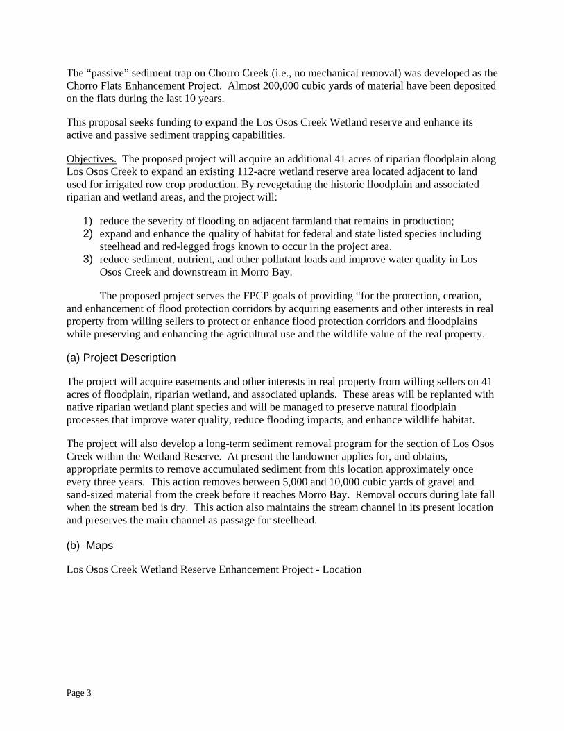
Los Osos Creek Wetland Reserve Enhancement Project - Location
Page 3
San Luis Obispo County Morro Bay Watershed
Morro Bay
1 mile
Pacific Ocean
Warden Creek
Project Area
Los Osos Creek
Page 4
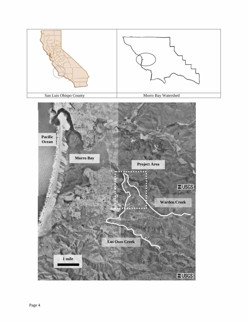
Existing Los Osos Creek
Wetland Reserve
Warden Creek
Proposed Expansion
Los Osos Creek
1,000 feet
Page 5
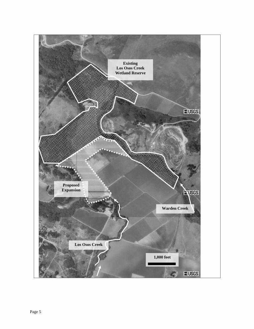
Existing Los Osos Creek
Wetland Reserve
Proposed Expansion
Warden Creek
Los Osos Creek
feet
Page 6
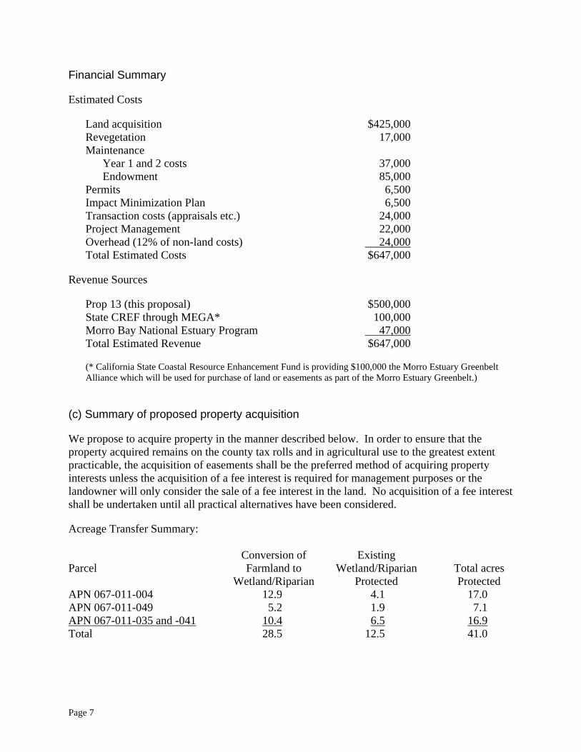
Financial Summary
Estimated Costs
Land acquisition $425,000 Revegetation 17,000 Maintenance
Year 1 and 2 costs 37,000 Endowment 85,000
Permits 6,500 Impact Minimization Plan 6,500 Transaction costs (appraisals etc.) 24,000 Project Management 22,000 Overhead (12% of non-land costs) 24,000Total Estimated Costs $647,000
Revenue Sources
Prop 13 (this proposal) $500,000 State CREF through MEGA* 100,000 Morro Bay National Estuary Program 47,000Total Estimated Revenue $647,000
(* California State Coastal Resource Enhancement Fund is providing $100,000 the Morro Estuary Greenbelt Alliance which will be used for purchase of land or easements as part of the Morro Estuary Greenbelt.)
(c) Summary of proposed property acquisition
We propose to acquire property in the manner described below. In order to ensure that the property acquired remains on the county tax rolls and in agricultural use to the greatest extent practicable, the acquisition of easements shall be the preferred method of acquiring property interests unless the acquisition of a fee interest is required for management purposes or the landowner will only consider the sale of a fee interest in the land. No acquisition of a fee interest shall be undertaken until all practical alternatives have been considered.
Acreage Transfer Summary: Conversion of Existing Parcel Farmland to Wetland/Riparian Total acres Wetland/Riparian Protected Protected APN 067-011-004 12.9 4.1 17.0 APN 067-011-049 5.2 1.9 7.1 APN 067-011-035 and -041 10.4 6.5 16.9Total 28.5 12.5 41.0
Page 7
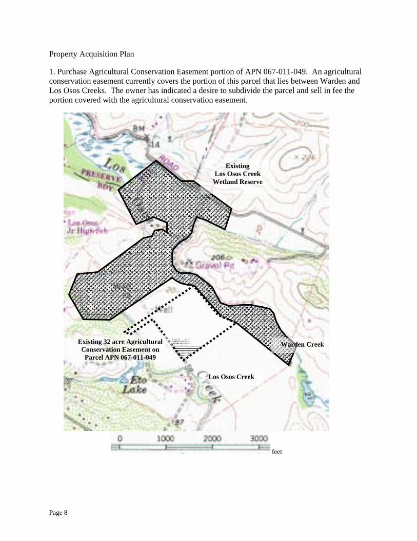
Property Acquisition Plan
1. Purchase Agricultural Conservation Easement portion of APN 067-011-049. An agricultural conservation easement currently covers the portion of this parcel that lies between Warden and Los Osos Creeks. The owner has indicated a desire to subdivide the parcel and sell in fee the portion covered with the agricultural conservation easement.
Existing Los Osos Creek
Wetland Reserve
Existing 32 acre Agricultural Conservation Easement on Parcel APN 067-011-049
Warden Creek
Los Osos Creek
feet
Page 8
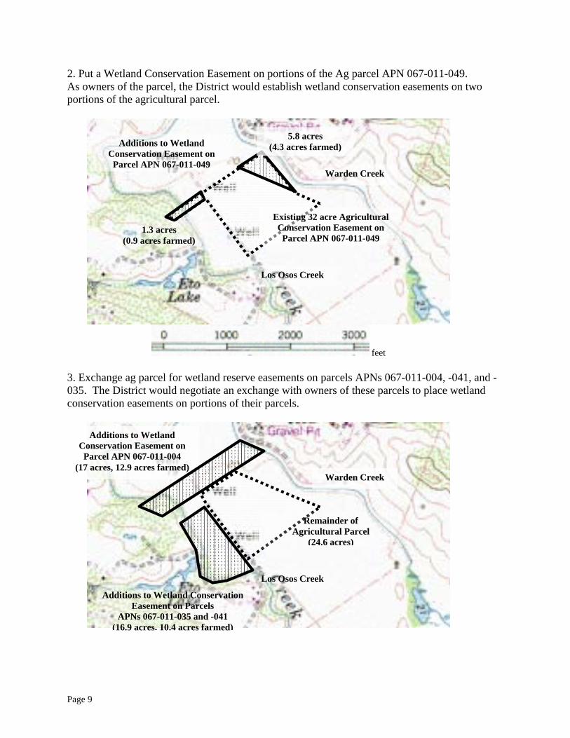
2. Put a Wetland Conservation Easement on portions of the Ag parcel APN 067-011-049. As owners of the parcel, the District would establish wetland conservation easements on two portions of the agricultural parcel.
Warden Creek
Existing 32 acre Agricultural Conservation Easement on Parcel APN 067-011-049
5.8 acres (4.3 acres farmed)
1.3 acres (0.9 acres farmed)
Additions to Wetland Conservation Easement on Parcel APN 067-011-049
Los Osos Creek
feet 3. Exchange ag parcel for wetland reserve easements on parcels APNs 067-011-004, -041, and - 035. The District would negotiate an exchange with owners of these parcels to place wetland conservation easements on portions of their parcels.
Warden Creek
Los Osos Creek
Additions to Wetland Conservation Easement on Parcel APN 067-011-004
(17 acres, 12.9 acres farmed)
Additions to Wetland Conservation Easement on Parcels
APNs 067-011-035 and -041 (16.9 acres, 10.4 acres farmed)
Remainder of Agricultural Parcel
(24.6 acres)
Page 9
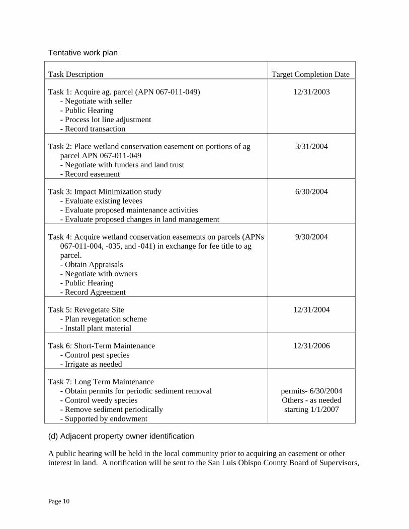
Tentative work plan
Task Description Target Completion Date
Task 1: Acquire ag. parcel (APN 067-011-049) - Negotiate with seller - Public Hearing - Process lot line adjustment - Record transaction
12/31/2003
Task 2: Place wetland conservation easement on portions of ag parcel APN 067-011-049 - Negotiate with funders and land trust - Record easement
3/31/2004
Task 3: Impact Minimization study - Evaluate existing levees - Evaluate proposed maintenance activities - Evaluate proposed changes in land management
6/30/2004
Task 4: Acquire wetland conservation easements on parcels (APNs 067-011-004, -035, and -041) in exchange for fee title to ag parcel. - Obtain Appraisals - Negotiate with owners - Public Hearing - Record Agreement
9/30/2004
Task 5: Revegetate Site - Plan revegetation scheme - Install plant material
12/31/2004
Task 6: Short-Term Maintenance - Control pest species - Irrigate as needed
12/31/2006
Task 7: Long Term Maintenance - Obtain permits for periodic sediment removal - Control weedy species - Remove sediment periodically - Supported by endowment
permits- 6/30/2004 Others - as needed starting 1/1/2007
(d) Adjacent property owner identification
A public hearing will be held in the local community prior to acquiring an easement or other interest in land. A notification will be sent to the San Luis Obispo County Board of Supervisors,
Page 10
adjacent landowners (see parcel numbers below), affected water and community service districts, local municipalities, and other interested parties.
Adjacent Properties:
APN 067-011-004 APN 067-011-041 APN 067-011-047 APN 067-011-026 APN 067-011-042 APN 067-011-047 APN 067-011-035 APN 067-011-045 APN 067-011-049
(e) Impact minimization plan
An impact minimization plan will be developed as part of this project to evaluate the impact of floodwaters, the structural integrity of the existing levees, agricultural husbandry practices, and the maintenance required for periodic sediment removal activities.
It is expected that the project will have minimal impacts for the following reasons:
• No changes are proposed to existing levees. • The proposed periodic sediment removal activities have taken place regularly in the past,
with no adverse impacts to adjacent property owners. • Planting native riparian species on existing agricultural land is not expected to have an
adverse impact to adjacent property owners.
(f) Local Participation in the Work Plan
The work plan was produced with the participation of the following local entities:
California State Coastal Conservancy Supported the efforts of the District to develop a management plan for Los Osos Creek.
Morro Estuary Greenbelt Alliance Supports the acquisition of land for public resource protection as part of the greenbelt. Provided technical information regarding sensitive species.
Morro Bay National Estuary Program Supported the efforts of the District to develop a management plan for Los Osos Creek.
(g) Maintenance Financing
The landowner has expressed interest in periodically removing sediment from the project area and selling the material, at a small profit. This arrangement will make periodic sediment removal a self-sustaining operation.
A trust fund worth $85,000 will be established to pay for other long-term maintenance costs. Assuming an average investment return rate of 4%, this fund will generate $3,400 per year. These funds would be sufficient to pay for approximately 4 days of labor from a full CCC work crew. Past experience has shown that this level of effort is sufficient to remove log-jam and for other vegetation management actions.
Page 11
(h) Wildlife habitat and agricultural land preservation benefit analysis
Wildlife habitat benefits: - Preserves steelhead passage to and from upper watershed. - Improves water quality in Los Osos Creek and Morro Bay (reduced temperatures, reduced sediment loads, reduced nutrient and pathogen loads.) - Provides enlarged corridor between coastal scrub habitats located to the east and west of the project. - Expands riparian wetland habitat.
Ag. land preservation benefits: - Risk is reduced because land that now frequently floods is taken out of production. - Continued agricultural operation is made more secure by obtaining long-term permits to continue periodic sediment removal.
(i) Project team’s qualifications
A summary of the efforts of Coastal San Luis Resource Conservation District as part of the Morro Bay Watershed Enhancement Project is presented below. This summary should provide a brief overview of the ability of the District to carry out the proposed project.
Morro Bay Watershed Enhancement Project 1987-2002
In 1987 the District obtained funding through the California State Coastal Conservancy (SCC) to quantify the historical loss of open water in the bay, and to locate and quantify sediment sources to the bay in order to create a baseline for future reference. The results of the study indicated that the bay had been filling in at a rate ten times greater during the last one hundred years than it had previously.
Using these studies as a baseline the RCD then hired the USDA Soil Conservation Service (now known as the Natural Resources Conservation Service) to develop the Morro Bay Watershed Enhancement Plan. The recommended plan detailed a three-part action plan. Part 1 I was land treatment. Part 2 was a sediment trap on Los Osos Creek. Part 3 was a sediment trap on Chorro Creek.
Technical and financial assistance were given to landusers to help them correct conservation problems. The RCD obtained a grant of $400,000 from the SCC to cost share with landusers on land treatment measures. The RCD contracted with the SCS to provide the technical assistance to get the job done.
The US Department of Agriculture has also contributed funding for the enhancement of the Morro Bay watershed. A USDA water quality program was initiated in 1991. Funds were made available to three USDA agencies for accelerated work within the area. The SCS received $700,000 over five years for increased technical assistance. The Agriculture Stabilization and Conservation Service (now known as the Farm Service Agency or FSA) received $100,000 for increased cost-sharing assistance to land users.
Page 12
IN 2001 the District received grants totaling $265,000 from the Packard Foundation, the State Coastal Conservancy, and the Morro Bay National Estuary to continue offering technical assistance and cost sharing to landowners who implement best management practices to reduce erosion and nonpoint source pollutant loads to Morro Bay. The USDA Natural resources Conservation Service provides in-kind support and also provide personnel through a fee-for-services arrangement.
To date over 245 conservation practices have been installed in the watershed through technical and financial assistance provided through the Morro Bay Watershed Enhancement Project (MBWEP). These projects have resulted in the prevention of over 172,000 tons of soil erosion. Additionally, MBWEP projects have caught an estimated 300,000 cubic yards of sediment before it reached the bay.
(j) Statement of Authority
The Coastal San Luis Resource Conservation District is chartered under Division 9 of the California Public Resource Code. Section 9403 states that “directors may accept gifts and grants of money from any source whatsoever to carry out the purposes of the District.” Secion 9404 states that “The directors may execute all necessary contracts.”
III. Minimum Qualifications
The project proposes to use granted funds for protection and enhancement of a flood protection corridor for Los Osos Creek in San Luis Obispo County, California.
The project is proposed by the Coastal San Luis Resource Conservation District, a local public agency.
The California Conservation Corps will provide labor whenever feasible. The District has a long and productive history of working with the Los Padres District of the CCC.
The District has considered alternatives to acquiring property in fee. Purchase of the property in fee will enable the District to trade the land for easements on the other affected parcels. The owner of the other parcels wants to continue farming, and is willing to trade the right to farm on those other parcels for the right to farm the parcel that the District will acquire. After the transactions are complete, the District will not own any of the parcels, but will hold wetland conservation easements on 41 acres. County property tax revenues will decrease to the extent that the wetland easements reduce the appraised value of the parcels.
The present landowner of parcel APN 011-067-049 has expressed an interest in selling the agricultural portion of his parcel in fee.
An impact minimization plan will be developed as part of this project to evaluate the impact of floodwaters, the structural integrity of the existing levees, agricultural husbandry practices, and the maintenance required for periodic sediment removal activities.
It is expected that the project will have minimal impacts for the following reasons:
Page 13
• No changes are proposed to existing levees. • The proposed periodic sediment removal activities have taken place regularly in the past,
with no adverse impacts to adjacent property owners. • Planting native riparian species on existing agricultural land is not expected to have an
adverse impact to adjacent property owners.
The project is located almost entirely within the 100-year floodplain of Los Osos Creek (ESRI, 2003 FEMA Digital Q3 Flood Data.)
Page 14
IV. (340 points) Flood Protection Benefits A. Existing and potential urban development in the floodplain (50)
1. Describe the existing and potential urban development at the site and the nature of the flood risk.
There is little existing urban development at the site. The potential for urban development is very low.
2. How often has flooding occurred historically?
The site has flooded from the Los Osos Creek side at least 3 times during the last 50 years. The site has flooded from the Warden Creek side more frequently – approximately once every 4 years.
3. Discuss the importance of improving the flood protection at this location. Include the number of people and structures that are affected by the flood hazard, and the flood impacts to highways and roads, railroads, airports and other infrastructure, and agriculture.
The primary benefit of flood protection on this site is to agricultural production.
There is a single home site downstream of the proposed project, located at the top of a small hill. The access driveway is subject to flooding.
Turri Road, downstream of the proposed project, is also subject to flooding.
B. Flood damage reduction benefits of the project (100) 1. Does the proposed project provide for transitory storage of floodwaters?
The proposed project does not increase the transitory storage of flood waters.
2. Describe any structural and non-structural flood damage reduction elements of the project.
Along Los Osos Creek the proposed project provides structural flood damage reduction by periodically removing sediment from a seasonally dry stream bed so that it is less likely to overtop its levees.
Along Warden Creek the proposed project provides non-structural flood damage reduction by acquisition of property for open space.
3. By what methods and by how much dollar value will the project decrease expected average annual flood damages?
Assuming 17 acres of low-lying farmland (along Warden Creek) protected from flooding once every 4 years with an average production cost of $2,000 per acre (typical for transplanted lettuce) results in an annual decrease in flood damage of $8,500 on the lower
Page 15
portion. Assuming 11 acres of farmland along Los Osos Creek protected from flooding once every 10 years would result in an annual decrease in flood damage of $2,200, bringing the total annual decrease in flood damage to $10,700.
4. How does the project affect the hydrologic and hydraulic conditions at the project site and adjacent properties?
In Los Osos Creek the proposed project changes the hydrologic and hydraulic conditions as follows:
• The water surface elevations are reduced because a portion of the channel has been dredged.
• Flow velocities are increased at the upper portion of the site because the channel slope has been increased, but are decreased at the lower portion of the site because the slope has been reduced, compared to pre-dredging conditions.
Along Warden Creek the proposed project does not affect the hydrologic and hydraulic conditions at the project site and adjacent properties.
C. Restoration of natural processes (60)
1. Describe how any natural channel processes will be restored and describe how these natural processes will affect flood management and adjacent properties.
In the past, “break outs” along Warden Creek were treated by restoring the low levee and forcing the creek back into its channel. The proposed project will change flood management along Warden Creek by allowing the creek to continue its natural process of meander formation, flooding, and sediment deposition.
Along Los Osos Creek, natural process will not be restored, and flood management will continue as it has been performed for many years: periodic removal of sediment from a dry stream channel.
2. Describe any upstream or downstream hydraulic or other effects.
Along Warden Creek no hydraulic structures will be modified so there will be little or no upstream or downstream hydraulic or other effects.
Along Los Osos Creek, the hydraulic effect of periodic dredging will be an increase in flow rates (and scouring) in the upper portion of the project, coupled with a decrease in velocity and the associated deposition in the lower portion of the project. The net effect will be to enhance the sediment trapping function of Los Osos Creek.
3. If the project includes channel modification or bank protection work, will riprap or dredging be part of the design? If so, provide an analysis of potential benefits and impacts.
Along Warden Creek the project does not include channel modification or bank protection work.
Page 16
Along Los Osos Creek the project includes periodic dredging. The benefits of dredging are reduced flood hazard, reduced sediment loads to Morro Bay, and preservation of a clearly defined channel for steelhead as they pass between Morro Bay and the upper Los Osos Creek watershed. Impacts of dredging to aquatic life are minimal because the stream regularly dries up during summer months.
D. Project effects on the local community (60) 1. How will the project impact future flooding on and off this site?
Along Warden Creek flooding will not be affected by the project. However, flood impacts will be reduced because flood-prone agricultural lands will be taken out of production.
The project will reduce on site flooding along Los Osos Creek.
2. How will the project affect emergency evacuation routes or emergency services and demands for emergency services?
No impact.
3. Explain how the project will comply with the local community floodplain management ordinance and the floodplain management criteria specified in the Federal Emergency Management Agency’s National Flood Insurance Program (FEMA’s NFIP).
San Luis Obispo County has a “Flood Hazard Area Permit and Processing Requirement” for projects proposed within a Flood Hazard Area (FHA) designation. (The FHA corresponds to the 100-year flood zone.) Within the FHA, any proposed structure will have special requirements, and any proposed project will require a drainage plan.
The proposed project is almost entirely within the FHA. No structures are planned. A drainage plan will be developed for the dredging activities planned as part of the proposed project. Therefore, the proposed project will comply with the local community floodplain ordinance.
E. Value of improvements protected (70) 1. What is the assessed value of structural improvements that will be protected
by the project?
No structural improvements are protected by the project.
2. What is the estimated replacement value of any flood control facilities or structures protected by the project?
Zero. (No structural improvements are protected by the project.)
Page 17
V. (340 points) Wildlife and Agricultural Land Conservation Benefits
The project primarily benefits wildlife by expanding and enhancing the riparian floodplain, and by preserving passage for steelhead trout. A secondary benefit is provided to agricultural land conservation by removing flood-prone areas from active production.
A. (340xFw points) Wildlife Benefits A1. Importance of the site to regional ecology (70)
1. Describe any habitat linkages, ecotones, corridors, or other buffer zones within or adjacent to the site. How are these affected by the project?
The site links aquatic habitats in lower Los Osos Creek and Morro Bay with aquatic habitat in upper Los Osos Creek. This is an important corridor for steelhead trout that spawn in the upper Los Osos Creek watershed.
The site expands the existing Los Osos Creek Wetland Reserve which is part of the Morro Estuary Greenbelt. The Morro Estuary Greenbelt serves as a wildlife corridor around the community of Los Osos between Montaña de Oro and Morro Bay State Parks.
The site also links coastal wetlands with costal sage scrub habitat.
2. Is the site adjacent to any existing conservation areas?
The site is immediately adjacent to the existing Los Osos Creek Wetland Reserve, a 112-acre site placed under a wetland conservation easement in 1995. The purpose of the easement is to restore and protect palustrine forested and palustrine emergent wetland habitat for wildlife including passerine birds and to maintain water quality and to establish wetland habitat for aesthetic quality.
The site is also adjacent to properties purchased as part of the Morro Estuary Greenbelt that surrounds the Community of Los Osos.
3. Describe any plans for aquatic restoration resulting in in-stream benefits.
The project plans to periodically remove sediment from a portion of Los Osos Creek. This section of creek typically dries completely by early summer. Periodic sediment removal from this area may increase the amount of time during which surface water is present during the following spring, and will also serve to preserve the channel in its present location, thereby preserving passage for steelhead and other aquatic species during winter flows.
4. Discuss any natural landscapes within the site that support representative examples of important, landscape-scale ecological functions (flooding, fire, sand transport, sediment trapping, etc.)?
Page 18
The margins and lower portions of the site support a native coastal riparian forest of cottonwoods, sycamores, willows, and associated shrubs. These areas collect sediment during flood events.
A2. Diversity of species and habitat types (70) 1. Does the site possess any:
i. areas of unique ecological and/or biological diversity? ii. vegetative complexity either horizontally or vertically?
The site contains California coastal wetlands. Within the Morro Bay estuary, these areas have unique biological diversity, supporting such species as Chorro Creek bog thistle, California sea-blite, Least Bell’s vireo, and Salt Marsh birds-beak. Vegetative complexity is apparent both vertically where low plant species such as red-osier dogwood, blackberry are partially shaded by willows, cottonwoods, and sycamores.
2. Describe habitat components including year-round availability of water, adequate nesting/denning areas, food sources, etc.
The project area contains riparian habitat (palustrine forested wetland), open water and channels (palustrine deepwater), freshwater marsh (palustrine emergent wetland), and riverine sand and mud bottoms. Fresh water is available year-round in Warden Creek. During most years fresh water can be found year-round in Los Osos Creek within 1,000 feet upstream and downstream of the project site.
Downstream habitats in the Morro Bay estuary include eelgrass (estuarine intertidal aquatic beds), mudflats (estuarine and intertidal unconsolidated shore), rocky shore (estuarine intertidal), sandy beaches (marine and estuarine intertidal shore), coastal salt marsh (estuarine emergent wetland), and brackish marsh (estuarine intertidal emergent wetland). 3. Describe any superior representative examples of specific species or
habitats.
The site provides habitat suitable for steelhead trout and the California red-legged frog. 4. Does the site contain a high number of species and habitat types? List
and describe.
The property contains riparian habitat that has been documented by the State Department of Fish and Game as habitat for Steelhead. The elimination of agricultural activity will enhance Steelhead spawning and rearing habitat.
According to the U.S. Fish and Wildlife Service and the California Department of Fish and Game habitat mapping of the project area and surrounding watershed, the project site provides known habitat for California red-legged frog as well as spawning and rearing habitat for the Southern steelhead trout. By acquiring and
Page 19
restoring riparian and upland habitat, the project will directly benefit upland habitat for the California red-legged frog as well as spawning and rearing habitat for the Southern steelhead trout.
In addition, the elimination of agricultural activity and the revegetation of the riparian corridor will together restore several acres of flood plain and thereby reduce excessive sediment and associated nutrient and bacteria loads flowing to the bay. Reducing sediment flows will serve to restore open water and wetland areas in the biologically rich south bay region and thus will directly benefit the Tidewater goby which is known to occur in this region.
5. Does the site contain populations of native species that exhibit
important subspecies or genetic varieties historically present prior to European immigration?
The site provides habitat suitable for steelhead trout that are part of the South/Central Coast evolutionary significant unit (ESU).
A3. Ecological importance of species and habitat types (100)
1. Discuss the significance of habitat types at this location and include any local, regional, or statewide benefits received by preserving or improving the area.
California coastal wetlands are considered one of the 21 most endangered ecosystems in the United States. 80 percent of the coastal wetlands have been converted to urban or agricultural uses. The project is adjacent to costal sage scrub habitat – another highly endangered ecosystem. It is estimated that 70-90 percent of southern California's coastal sage scrub has been destroyed.
2. Does the site contain any significant wintering, breeding, or nesting areas? Does it fall within any established migratory corridors? What is the level of significance? How are these affected by the project?
Morro Bay is a critical link on the Pacific Flyway, is nearly always within the top ten sites in the nation for Christmas Bird Count, and is ranked first in the nation in Audubon Society’s “Big Sit” survey. Sensitive bird species found in the project area include Merlin (Falco columbarius), Ferruginous Hawk (Buteo regalis), Sharp-shinned Hawk (Accipiter striatus), Peregrine Falcon (Falco peregrinus), Prarie Falcon (Falco mexicana), Golden Eagle (Aquila chysaetos), Willow Flycatcher (Empidonax traillii), Yellow Warbler (Dendroica petechia), and the Yellow-breasted Chat (Ictera virens). Expansion of the coatsl riparian habitat is expected to benefit these and other species. In the Chorro Flats Enhancement Project, a similar floodplain restoration site located approximately 3 mile to the north, avian monitoring activities have observed as many as 36 species of birds. Therefore it can be expected that the proposed project will benefit resident and migratory birds.
Page 20
3. Describe any existing habitats that support any sensitive, rare, “keystone” or declining species with known highly restricted distributions in the region or state. Does the site contain any designated critical habitat? How are these affected by the project?
Los Osos Creek support a diverse community of flora and fauna, including the California red legged frog and steelhead trout. The project will primarily benefit steelhead by preserving passage through the site. The project may also benefit the red legged frog by lowering the channel bottom, thereby providing additional temporary open water habitat for breeding or foraging.
4. What is the amount of shaded riverine aquatic (SRA) and riparian habitat to be developed, restored, or preserved?
In length, approximately 3500 feet of SRA habitat will be restored and preserved. In area, approximately 29 acres of riparian habitat will be restored, and another 12 acres will be preserved.
A4. Public benefits accrued from expected habitat improvements (60) 1. Describe present public use/access, if any.
Public access is not part of this project.
2. Discuss areas on the site that are critical for successfully implementing landscape or regional conservation plans. How will the project help to successfully implement the plans?
The proposed project will place additional acreage into public trust as part of the Morro Estuary Greenbelt. Although not critical to the greenbelt, the proposed project serves to expand the size of the wildlife corridor the greenbelt affords, thereby increasing its effectiveness.
3. Describe the surrounding vicinity. Include the presence or absence of large urban areas, rapidly developing areas, and adjacent disturbed areas with non-native vegetation and other anthropogenic features. Do any surrounding areas detract from habitat values on the site?
The existing Los Osos Creek Wetland reserve is to the north of the project. To the northeast and east, coastal dune scrub habitat shares space with two home sites and a closed landfill. To the southeast and south land use is agricultural – vegetable production on the lower flat lands and cattle grazing on the rolling hills. To the south and southwest low density housing units are found behind the adjacent fields of vegetables. To the west protected coastal dune habitat is immediately adjacent to the project to the west. Further west is found the suburban community of Los Osos (population: 14,351).
None of the immediately surrounding areas detract from the habitat values on site.
Page 21
4. Describe compatibility with adjacent land uses.
Adjacent land uses include agriculture and rural residential. Agricultural operations are confined to areas that will not be affected by the proposed project. Rural residential land uses are located on higher ground that is not affected by the project. Therefore, the proposed project is compatible with all adjacent land uses.
A5. Viability/sustainability of habitat improvements (40) 1. Describe any future operation, maintenance and monitoring activities
planned for the site. How would these activities affect habitat values?
During past years when Los Osos Creek flooded, the creek developed multiple shallow streams through the agricultural lands. These multiple shallow streams created a barrier to steelhead movement. Los Osos Creek will be periodically dredged to preserve a single flow path and reduce the possibility that it will overtop its levees and flood the adjacent fields. The dredging work will take place during late summer when the creek bed is dry. The negative impact of this disturbance will be offset by the benefit of preserving a single flow path in the creek for steelhead passage.
Periodically large trees wash down Los Osos and Warden Creeks. During some years, enormous log jams form which increase flood hazards, accelerate bank erosion, and block passage of steelhead trout. These logjams will be reduced in size as needed using California Conservation Corps crews using hand tools. This work will improve passage for steelhead trout.
2. Does the site contain large areas of native vegetation or is it adjacent to large protected natural areas or other natural landscapes?
The proposed project contains approximately 12.5 acres of native coastal riparian vegetation. It is adjacent to the 112-acre wetland reserve which contains large amounts of native vegetation. The project site is also adjacent to protected natural areas that are part of the Morro Estuary Greenbelt.
3. Is the watershed upstream of the site relatively undisturbed or undeveloped and likely to remain so into the foreseeable future?
The site receives drainage from almost the entire 17,000 acre Los Osos Creek watershed. Over half the watershed is in rangeland, 20% is brushland or woodland, 20% has been developed to urban uses, and 8% is developed to grain and field crops. Development of the watershed to urban uses is expected to continue as California’s human population increases.
4. Describe any populations of native species or stands of native habitats that show representative environmental settings.
The site exists at the intersection of two highly endangered ecosystems: coastal wetlands and costal sage scrub.
Page 22
B. (340xFa points) Agricultural Land Conservation Benefits
B1. Potential productivity of the site as farmland (120) 1. Describe the quality of the agricultural land based on land capability,
farmland mapping and monitoring program definitions, productivity indices, and other soil, climate and vegetative factors.
Soils at the site have been mapped as Corralitos Variant sandy loam, Marimel sandy clay loam, occasionally flooded, and Marimel silty clay loam, drained. The Corralitos and Marimel sandy clay loam are classified as capability unit IIIw-2. These soils are expected to have severe limitations related to drainage or flooding. The Marimel silty clay loam, drained, is classified as capability class I, having only slight limitations on use for producing field crops. However, these fields have cultivated regularly for many years and continue to produce profitable returns to the growers.
2. Are projected agricultural practices compatible with water availability?
Present agricultural operations are irrigated by wells located on site. The proposed project will reduce the amount of land under cultivation, and thereby reduce the amount of irrigation needed. Therefore, projected agricultural practices are compatible with water availability.
3. Does the site come with riparian, mineral, and/or development rights?
The parcel that will be acquired in fee comes with riparian rights. The development and mineral rights were retired when the agricultural conservation easement was placed on the property.
4. Is the site large enough to sustain future commercial agricultural
production?
Yes. After the land transactions are complete, 25 acres will remain in agricultural production. This area will be adjacent to fields that are currently used for agricultural production. The net effect of the land transactions will be to consolidate the agricultural holdings of one of the participating landowners.
5. Does the site contain any adverse or beneficial deed restrictions
affecting agricultural land conservation?
The parcel that will be acquired in fee is restricted to agricultural uses under an agricultural conservation easement.
6. Describe the present type of agricultural use including the level of
production in relation to the site’s productivity potential. What is the condition of the existing infrastructure that supports agriculture uses?
Page 23
The site is currently operated the achieved its highest potential with regards to vegetable production. The site produces vegetables on a year-round basis. Supporting infrastructure includes irrigation capabilities, access to transportation, and an available pool of experienced labor.
B2. Farming practices and commercial viability (40) 1. Does the area possess necessary market infrastructure and
agricultural support services?
Yes. 2. Are surrounding parcels compatible with commercial agricultural
production?
Yes.
3. Is there local government economic support in place for agricultural enterprises including water policies, public education, marketing support, and consumer and recreational incentives?
Yes.
4. Describe any present or planned future environmentally friendly farm practices (no till, erosion control, wetlands avoidance, eco-friendly chemicals, recycling wastes, water conservation, biological pest control).
None. B3. Need and urgency for farmland preservation measures (70)
1. Is the project site under a Williamson Act contract?
Yes. 2. Describe the surrounding vicinity. Include the presence or absence of
large urban areas, rapidly developing areas, low density ranchette communities, and adjacent disturbed areas with non-native vegetation and other human-induced features. Do any surrounding areas detract from agricultural values on the site?
The existing Los Osos Creek Wetland reserve is to the north of the project. To the northeast and east, coastal dune scrub habitat shares space with two home sites and a closed landfill. To the southeast and south land use is agricultural – vegetable production on the lower flat lands and cattle grazing on the rolling hills. To the south and southwest low density housing units are found behind the adjacent fields of vegetables. To the west protected coastal dune habitat is
Page 24
immediately adjacent to the project to the west. Further west is found the suburban community of Los Osos (population: 14,351).
None of the immediately surrounding areas detract from the agricultural values on site. 3. What types of conversion or development are likely on neighboring
parcels? What are the land uses of nearby parcels? Describe the effects, if any, of this project to neighboring farming operations or other neighboring land uses.
Within the next 20 years individual home sites are expected to be developed on the few neighboring parcels where such development is possible.
This project will benefit neighboring agricultural operations by consolidating the agricultural operations of one of the neighboring landowners. 4. Describe the relationship between the project site and any applicable
sphere of influence.
The project is within the sphere of influence of the community of Los Osos.
5. Is the agricultural land use on the project site consistent with the local General Plan? Does the General Plan demonstrate commitment to long-term agricultural conservation?
Yes. Yes.
B4. Compatibility of project with local government planning (50) 1. Is the agricultural land use on the project site consistent with the local
General Plan? Does the General Plan demonstrate commitment to long-term agricultural conservation?
Yes. Yes. 2. What is the present zoning and is the parcel developable?
The parcels are zoned agriculture. The parcel to be acquired cannot be developed because it is covered with an agricultural conservation easement. The other parcels may theoretically be developable, but lie largely within the 100-year flood plain, and are therefore not considered developable due to flood hazards.
3. Is there an effective right to farm ordinance in place?
Yes.
4. Is the project description consistent with the policies of the Local Agency Formation Commission?
Page 25
Yes. Yes.
5. Will the project as proposed impact the present tax base?
After the transactions are complete, the District will not own any of the parcels, but will hold wetland conservation easements on 41 acres. County property tax revenues will decrease to the extent that the wetland easements reduce the appraised value of the parcels.
B5. Quality of agricultural conservation measures in the project (50) 1. For agriculture lands proposed for conservation, describe any
additional site features to be conserved that meet multiple natural resource conservation objectives, including wetland protection, wildlife habitat conservation, and scenic open space preservation where the conservation of each additional site feature does not restrict potential farming activities on the agriculture portions of the site.
The project does not increase the amount of land under agricultural conservation easement. 2. What are the present biological/ecological values to wildlife? How are
these values affected by the proposed project?
At present the biological and ecological values to wildlife of the parcel to be acquired, and the other parcels involved, are low. These values will be increased as the wetland habitat portions of the project are developed. 3. Is the project proponent working with any local agricultural
conservancies or trusts?
No. 4. Does conservation of this site support long-term private stewardship of
agricultural land? How does this proposal demonstrate an innovative approach to agricultural land conservation?
The project increases the amount of privately held land on lower Los Osos Creek that is preserved for wetland functions or agricultural production.
5. Without conservation, is the land proposed for protection likely to be
converted to non-agricultural use in the foreseeable future?
No.
Page 26
VI. (320 points) Miscellaneous Benefits and Quality of Proposal
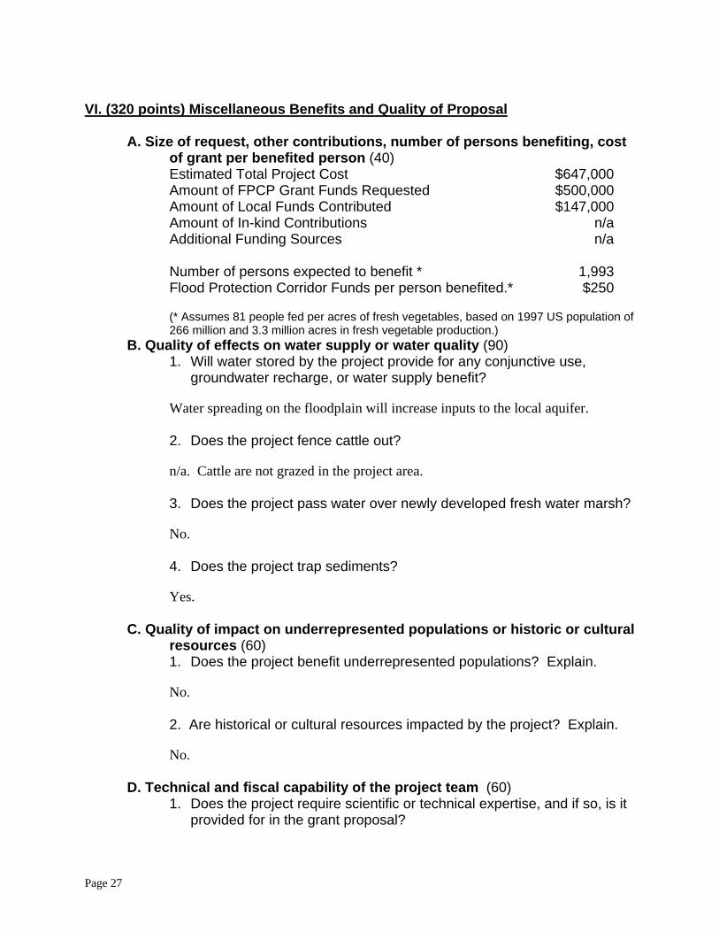
A. Size of request, other contributions, number of persons benefiting, cost of grant per benefited person (40)
Estimated Total Project Cost $647,000 Amount of FPCP Grant Funds Requested $500,000 Amount of Local Funds Contributed $147,000 Amount of In-kind Contributions n/a Additional Funding Sources n/a Number of persons expected to benefit * 1,993 Flood Protection Corridor Funds per person benefited.* $250
(* Assumes 81 people fed per acres of fresh vegetables, based on 1997 US population of 266 million and 3.3 million acres in fresh vegetable production.)
B. Quality of effects on water supply or water quality (90) 1. Will water stored by the project provide for any conjunctive use,
groundwater recharge, or water supply benefit?
Water spreading on the floodplain will increase inputs to the local aquifer. 2. Does the project fence cattle out?
n/a. Cattle are not grazed in the project area.
3. Does the project pass water over newly developed fresh water marsh?
No.
4. Does the project trap sediments?
Yes.
C. Quality of impact on underrepresented populations or historic or cultural resources (60)
1. Does the project benefit underrepresented populations? Explain.
No. 2. Are historical or cultural resources impacted by the project? Explain.
No.
D. Technical and fiscal capability of the project team (60) 1. Does the project require scientific or technical expertise, and if so, is it
provided for in the grant proposal?
Page 27
No. 2. Grant funds will be available in phases. What monitoring and reporting
mechanisms are built into your administrative plan to track progress, initiation, and completion of successive phases?
Regular quarterly reports are a standard part of all District projects. This reporting will provide a sufficient feedback loop to ensure that successive phases are completed.
3. Please outline your team’s management, fiscal and technical capability
to effectively carry out your proposal. Mention any previous or ongoing grant management experience you have.
See response to question II (i) above.
E. Coordination and cooperation with other projects, partner agencies, and affected organizations and individuals (80) 1. List cost sharing and in-kind partners and any other stakeholders
involved with your project and indicate the nature of their contribution, if any. Address the team’s ability to leverage outside funds.
The primary cost sharing partners in this project are the California State Coastal Conservancy, the Morro Estuary Greenbelt Alliance (MEGA), and the Morro Bay National Estuary Program (MBNEP). The proposed project makes use of matching funds from MEGA and the MBNEP. The District has a successful history of working together with these organizations to leverage outside funds. 2. Does your project overlap with or complement ongoing activities being
carried out by others? If so, indicate any coordination that has taken place to date or is scheduled to take place in the future.
The District has worked cooperatively with many of the partners of the Morro Bay National Estuary Program to carry out actions that reduce nonpoint source pollutant loads to Morro Bay and that improve wildlife habitat values within the bay and its watershed. The proposed project is a critical component of the MBNEP Comprehensive Conservation and Management Plan for Morro Bay. All the actions of the District within the Morro Bay watershed are highly coordinated with the MBNEP and relevant stakeholders through continued participation in the Implementation and Executive Committees of the MBNEP, and through joint projects such as the proposal before you today.
3. Will this application, if approved, begin the next phase of a previously
approved project or advance an ongoing project substantially toward completion?
Page 28
Yes. This project will advance the development of the sediment trap on Los Osos Creek that is a significant component of the Morro Bay Watershed Enhancement Plan, a watershed-wide sediment control project initiated in 1989. Development of this trap was first initiated in 1995 when a wetland conservation easement was placed on 112 acres located immediately downstream of the project site.
4. Describe how the proposal demonstrates a coordinated approach
among affected landowners, local governments, and nonprofit organizations. If other entities are affected, is there written support for the proposal and a willingness to cooperate?
The proposed project is a coordinated effort supported by the California State Coastal Conservancy, the Morro Bay National Estuary Program, and the USDA Natural Resources Conservation Service, among others. Please see the attached letter of support from the Morro Bay National Estuary Program.
Page 29


![2017 Central Valley Flood Protection Plan Update: Overview · 2017 Central Valley Flood Protection Plan Update: Overview [TRACKING NUMBER] 2012 Central Valley Flood Protection Plan](https://img.pdfslide.us/doc/110x75/600b701285d0f2151664ff2e/2017-central-valley-flood-protection-plan-update-overview-2017-central-valley-flood.jpg)