Embed Size (px)
Citation preview

1
FINAL SCOPE OF WORK TO PREPARE A DRAFT ENVIRONMENTAL IMPACT STATEMENT FOR THE
PROPOSED DOMINO SUGAR REZONING
This document is the Final Scope of Work (“Final Scope”) for the proposed Domino Sugar Rezoning Draft Environmental Impact Statement (DEIS). This Final Scope has been prepared to describe the proposed project, present the proposed framework for the Environmental Impact Statement (EIS) analysis, and discuss the procedures to be followed in the preparation of the DEIS. In accordance with the State Environmental Quality Review Act (SEQRA) and the City Environmental Quality Review (CEQR) procedures, a Draft Scope of Work (“Draft Scope”) was prepared in accordance with those laws and regulations and the City’s CEQR Technical Manual and distributed for public review. A public hearing was held on July 31, 2007 at Spector Hall, Department of City Planning, 22 Reade Street, New York, NY 10007. Written comments were accepted from issuance of the Draft Scope through the public comment period, which ended August 10, 2007.
This Final Scope incorporates changes in response to the comments on the Draft Scope as well as other background and project updates that were made subsequent to publication of the Draft Scope. The substantive changes to the proposed project and impact assessment methodologies since the Draft Scope was issued are as follows:
• The rezoning of three full or partial blocks to the east of the project site has been removed from the proposed actions.
• The analytical framework for the DEIS has been updated to include a development program as the “future without the proposed project” scenario that would occur absent the proposed discretionary actions. Since the issuance of the Draft Scope, the complex of buildings on the project site known as the Refinery has been designated a New York City Landmark (NYCL), and redevelopment of portions of the project site absent the proposed discretionary actions would be feasible and necessary in order to generate revenues that can be used for the required maintenance and upkeep of the landmarked Refinery.
• The proposed project includes an addition to the Refinery, a portion of which rises to 3 stories and a portion of which is 4 stories. LPC voted to approve the proposed addition and other minor alterations on June 24, 2008. LPC’s findings with respect to the appropriateness of the proposed alterations on the landmarked Refinery are contained in a Status Update Letter issued by LPC on June 26, 2008 but the actual Certificate of Appropriateness has not yet been issued.
• The number of proposed accessory parking spaces has been increased from 1,450 to 1,694 in order to accommodate the proposed project’s anticipated parking demand on-site. The proposed number of accessory parking spaces exceeds the number permitted in the northern parking facility under the proposed zoning districts, and therefore an additional special permit for accessory parking spaces has been added to the list of proposed actions.

Domino Sugar Rezoning
2
• The analysis year for the DEIS has been changed from 2016 to 2020 as it is anticipated that the entire proposed project may not be completed and occupied until 2020.
• On a portion of Site A, the applicant has modified the program to include commercial office, additional retail, and potential community facility use. An additional special permit to allow residential and commercial uses to be located at the same level within this building has been added to the list of proposed actions.
• The study area traffic network has recently changed, including recent directional changes to Kent Avenue, to accommodate the addition of bicycle lanes on Kent and Wythe Avenues and on Broadway. These changes will be assessed in the traffic analysis, as described in detail below in Task 17.
• Assessments of pedestrian wind conditions, greenhouse gas emissions, and an on-site cogeneration facility alternative have been added to the DEIS, as described below in Tasks 9, 19, and 23, respectively.
Deletions are not shown in this document. However, where relevant and appropriate, new text and editorial changes to the Draft Scope have been incorporated into the Final Scope and are indicated by double-underlining.
A. INTRODUCTION The Refinery LLC (“the applicant”) is proposing discretionary approvals in connection with the redevelopment of the former Domino Sugar site along the East River waterfront in Williamsburg, Brooklyn. The proposed project would include residential, retail/commercial, and community facility uses and open space. The “project site” is composed of Block 2414, Lot 1, which is located along the East River waterfront between Grand and South 5th Streets (“the waterfront parcel”), and Block 2428, Lot 1, which is located on the east side of Kent Avenue between South 3rd and South 4th Streets (“the upland parcel”). The project site (see Figure 1) is located entirely within Brooklyn Community District 1. The project site is currently zoned M3-1 for heavy industrial use (see Figure 2).
The Refinery LLC is owned by Refinery Management LLC, which is a joint venture of CPC Resources, Inc. and Katan Group LLC. CPC Resources is the managing member of the Refinery LLC and is the for-profit development arm of The Community Preservation Corporation, a not-for-profit corporation formed in 1974 that specializes in financing affordable housing. CPC Resources was created in 1992. Its mission is to develop affordable housing in communities throughout New York and New Jersey.
As described in greater detail below under “Project Description,” the proposed actions include:
• A zoning map amendment (i) from M3-1 to: R8 with a C2-4 commercial overlay for a portion of the waterfront parcel; (ii) from M3-1 to C6-2 for portions of the waterfront parcel; and (iii) from M3-1 to R6 with a C2-4 commercial overlay on the upland parcel (see Figure 3).
• A zoning text amendment to ZR 23-953, 62-35, 62-352, and Appendix F of the ZR to apply the Inclusionary Housing program and related floor area regulations which currently apply only in certain areas of Williamsburg-Greenpoint (on the waterfront from North 3rd Street in Williamsburg to Manhattan Avenue in Greenpoint and in R7-3 zoning districts in Brooklyn

EA
ST
RI V
ER
S. 1ST ST.
GRAND ST.
METROPOLITAN AVE.
N. 3RD ST.
N. 4TH ST.
N. 5TH ST.
N. 6TH ST.
N. 7TH ST.
KENT AVE.
WYTH
E AVE.
BERRY ST.
BEDFORD AV
E.
DRIGGS AV
E.
ROEBLING S
T.
HAVEMEYER S
T.
BQE
S. 2ND ST.
S. 3RD ST.
S. 4TH ST.
GRAND
S. 5TH ST.
S. 6TH ST.
WILLIAMSBURG BRIDGE
S. 8TH ST.
BROADWAY
S. 9TH ST.
S. 10TH ST.
S. 11TH ST.
DIVISION AVE.
MORTON ST.
CLYMER ST.
TAYLOR ST.
WYT
HE A
VE.
8.1.
08
Project Site LocationFigure 1 DOMINO SUGAR REZONING
N
SCALE
0 1000 FEET
BROOKLYN
QUEENS
MA
NH
ATTA
N
Area of Detail
Project Site Boundary and Area of General Large Scale Plan

EA
ST
R
IVE
R
WILLIAMSBURG
BRIDGE
R6
C4-3
Existing ZoningFigure 2
SCALE
0 400 FEET
DOMINO SUGAR REZONING
1.8.
09
Project Site Boundary
Area Proposed for Rezoning
Zoning District Boundary
C2-4 Overlay
Special Purpose District

R8
C6-2
R8 R6
C6-
2C
6-2
M1-2/R6M1-2/R6
M1-2
M3-
1
M3-1
R6
M3-1
R6
M3-1
M1-2
M3-
1
EA
ST
R
IVE
R
WILLIAMSBURG BRIDGE
8.27
.09
Proposed ZoningFigure 3
SCALE
0 400 FEET
Approximate location of existing platform
DOMINO SUGAR REZONING
235’
N
Project Site Boundary
Area Proposed for Rezoning
Existing Zoning District Boundary
Bulkhead Line
Proposed Zoning District
C2-3 Overlay
C2-4 Overlay
Proposed C2-4 Overlay
Special Purpose District
R8

Final Scope of Work
3
Community District 1) to the project site (the Inclusionary Housing Program permits a “floor area bonus” from 2.43 to 2.75 for R6 districts and from 4.88 to 6.5 for R8 districts).
• A zoning text amendment to ZR Section 52-83 to modify the requirements of non-conforming signs to permit a sign on the Refinery Building as per the approval from the New York City Landmarks Preservation Commission (LPC). This would permit a sign on the Refinery as per the approval received from the LPC on June 24, 2008 for the addition and for minor building modifications for the adaptive reuse of the Refinery.
• Designation of the project site as a General Large Scale Development and Special Permits for a General Large Scale Development pursuant to ZR Section 74-74: • Special Permits to modify the waterfront height and setback regulations otherwise
applicable pursuant to ZR Section 62-341 to: • Special Permit to allow the transfer of up to approximately 190,000 zoning square feet
(zsf) of floor area development rights across Kent Avenue to the upland parcel from the waterfront parcel;
• Special Permits to modify the required dimensions of an inner court recess as per ZR Section 23-852 for a building on the waterfront parcel, the required distance between windows in an inner court as per ZR Section 23-863 for buildings on the waterfront parcel, the required distance between buildings regulations of ZR Section 23-711 for a building on the waterfront parcel, and the rear yard regulations of ZR Sections 23-533 and 62-513 for the upland parcel and the waterfront parcel;
• Special Permit pursuant to ZR Section 74-744(b) to modify ZR Section 32-42 to permit commercial uses at the same level as residential uses within separate segments of the same building.
• A Special Permit pursuant to ZR Section 74-53 to permit, within the General Large Scale Development, a parking facility on the waterfront parcel to exceed the prescribed maximums of ZR Sections 25-12 and 36-12 by up to 316 parking spaces.
• An authorization, pursuant to ZR Section 62-822(a) for modification of waterfront access requirements of ZR Section 62-50 to achieve a superior open space plan.
• An authorization, pursuant to ZR Section 62-822(b) for modification of waterfront design requirements of ZR Section 62-513 and ZR Section 62-60 to achieve a superior open space plan.
• An authorization for phased implementation of waterfront access requirements pursuant to ZR 62-822(c) to permit the phased implementation of waterfront public access improvements in coordination with phased development of the site.
• CPC chair certification pursuant to ZR Section 62-811 for compliance with waterfront public access and visual corridor requirements.
• CPC chair certification to subdivide a waterfront zoning lot while maintaining compliance with all waterfront public access requirements.
• Coastal Zone Consistency determination (because the project site is within the Coastal Zone).
The proposed project will require approvals from the U.S. Army Corps of Engineers (USACE) and the New York State Department of Environmental Conservation (NYSDEC) for reconstruction of the existing waterfront platform and installation of a new sheet pile bulkhead. Approvals will also be required for the two proposed stormwater outfalls to be located at the end

Domino Sugar Rezoning
4
of South 2nd and South 3rd Streets. Additionally, a State Pollution Discharge Elimination System (SPDES) permit from the NYSDEC will also be required for stormwater discharges during the construction period because construction on the project site involves more than one acre.
The proposed actions would facilitate a proposal by the applicant to develop a total of approximately 2.81 million gross square feet (gsf) of floor area above grade. Approximately 2.44 million gsf would be dedicated to residential use, up to 127,537 gsf to retail/commercial use, up to 146,451 gsf to community facility use, and up to 98,738 gsf to commercial office space. The project site would include approximately four acres of public open space.
Because the program for the reuse of the Refinery complex is still being formulated, a variety of potential uses are being considered. The proposed C6-2 zoning on the Refinery site would allow for a range of residential, retail/commercial, and community facility uses for the Refinery. The applicant currently intends to build 2,200 residential units on the project site, of which 660 units would be affordable to low- and moderate-income households. However, it will be assumed for analysis purposes in the EIS that the project would include up to 2,400 residential units, 30 percent of which would be affordable to low- and moderate-income households. The 2,400 residential units are based on average unit size of approximately 1,000 gsf within 2.44 million gsf of residential floor area. The applicant intends to provide affordable housing using the City’s Inclusionary Housing bonus program. The project, if approved in its current form, envisions achieving a goal of 30 percent affordable housing. The proposed project would also incorporate waterfront public access areas (as required pursuant to ZR 62-40), including a shore public walkway, upland connections, visual corridors, and additional publicly accessible open space of approximately one acre on the waterfront side of the Refinery complex (see Figure 4). The waterfront esplanade would run the entire length of the site’s waterfront, connecting on the south with the terminus of South 5th Street and on the north with Grand Ferry Park at the end of Grand Street. The number of parking spaces for the proposed project would be 1,694 spaces.
If the proposed actions are approved, the entire project would be completed and occupied by 2020. Because the proposed actions are subject to discretionary review by the City Planning Commission (CPC), CPC will be the lead agency for the environmental review of this project. The proposed actions are subject to CEQR.
B. PROJECT DESCRIPTION
SITE CONDITIONS AND HISTORY
The approximately 11-acre project site is comprised of two parcels: a waterfront parcel (Block 2414, Lot 1) and an upland parcel (Block 2428, Lot 1). The waterfront parcel is approximately 9.9 acres (excluding the approximately 6.2 acres of land underwater to the pierhead line) and the upland parcel is approximately 1.3 acres. The waterfront parcel is bounded on the west by the East River, on the north by Grand Street, on the east by Kent Avenue, and on the south by South 5th Street, which separates the site from the Williamsburg Bridge immediately to the south. Grand Street ends at the Grand Ferry Park (1.8 acres), which is a public park that provides access to the East River. The block on which the upland parcel is located is bounded on the west by Kent Avenue, on the north by South 3rd Street, on the east by Wythe Avenue, and on the south by South 4th Street.

SITE E
SITE ASITE BREFINERY
E A S T R I V E R
SITE C
SITE D
SOU
TH 3
RD S
TREE
T
SOU
TH 4
TH S
TREE
T
SOU
TH 5
TH S
TREE
T
SOU
TH 2
ND
STR
EET
SOU
TH 1
ST S
TREE
T
GRA
ND
STR
EET
KENT AVENUE
KENT AVENUE
RIVER STREET
12.29.09
Illustrative Site PlanFigure 4DOMINO SUGAR REZONING
N
Sour
ce: R
afae
l Vin
oly
Arch
itect
s
Project Site Boundary

Final Scope of Work
5
Although sugar refining had taken place on the project site since the 1850’s, the oldest existing refinery buildings were built in the 1880’s and the most recent in the 1960’s. Domino Sugar operated on the site until 2001, when the company was acquired by American Sugar Refining. American Sugar closed most operations on the site in early 2004 and most of the buildings were vacated. The project site was purchased by the applicant in June 2004, subsequent to the closure of manufacturing operations.
Reflecting the project site’s historical use, the entire development site is currently zoned M3-1, a zoning designation that permits heavy industrial and manufacturing uses and limited commercial uses. The waterfront portion of the site, which stretches for approximately 1,300 feet along the East River, is a complex of industrial buildings ranging in height from one to 16 stories. These buildings include warehouses, sugar processing buildings, power-generating facilities, and research and design structures. The buildings on the project site are currently unoccupied. LPC designated the three buildings which comprise the Refinery (individually known as the Filter House, the Pan House, and the Finishing House) as NYCLs on September 25, 2007. The portion of the project site east of Kent Avenue, now a vacant lot, was formerly used as a parking lot.
All of the East River shoreline along the project site is developed with an existing platform and bulkhead. The pier/platform, which covers about 1.3 acres over the water, is a pile-supported deck that is in fair to moderate structural condition. It was formerly used for the docking of cargo ships and there are cranes and other maritime infrastructure along the water's edge.
The project site is adjacent to the area rezoned in May 2005 as part of the Greenpoint-Williamsburg rezoning. That rezoning project, which included the rezoning of approximately 184 blocks for residential and mixed residential/industrial use, made use of a combination of R6 and R8 districts along the waterfront to the north of the project site to facilitate residential redevelopment with public waterfront access and open space. The Greenpoint-Williamsburg rezoning also incorporated an inclusionary zoning mechanism to incentivize the development of affordable housing. The currently proposed rezoning of the Domino Sugar site and the surrounding upland blocks would be contiguous with the area rezoned as part of the Greenpoint-Williamsburg rezoning.
PROPOSED ACTIONS
For the project to be developed as proposed, the following approvals are necessary from CPC and the City Council:
• A zoning map amendment (i) from M3-1 to: R8 with a C2-4 commercial overlay for a portion of the waterfront parcel; (ii) from M3-1 to C6-2 for portions of the waterfront parcel; and (iii) from M3-1 to R6 with a C2-4 commercial overlay on the upland parcel (see Figure 3). The existing M3-1 zoning district is a heavy manufacturing district which allows industrial uses at a maximum FAR of 2.0, and does not allow residential use. The proposed R8 district is a residential district which allows residential use at a maximum FAR of 6.02. The proposed C2-4 commercial overlay district allows local-serving commercial uses at a maximum FAR of 2.0 when mapped within a R8 district. The proposed C6-2 district is a commercial district which allows a wide range of uses, including residential use at a maximum 6.02 FAR, commercial uses at 6.0 FAR, and community facility uses at 6.5 FAR. The proposed R6 district is a residential district which allows residential use at a maximum FAR of 2.43. The proposed C2-4 commercial overlay allows a maximum FAR of 2.0 when mapped within a R6 district. The areas affected by this zoning map amendment are controlled by the applicant. (ULURP No. 100185ZMK)

Domino Sugar Rezoning
6
• A zoning text amendment to ZR 23-953, 62-35, 62-352, and Appendix F of the ZR to apply the Inclusionary Housing program and related floor area regulations which currently apply only in certain areas of Williamsburg-Greenpoint (on the waterfront from North 3rd Street in Williamsburg to Manhattan Avenue in Greenpoint and in R7-3 zoning districts in Brooklyn Community District 1) to the project site (the Inclusionary Housing Program permits a “floor area bonus” from 2.43 to 2.75 for R6 districts and from 4.88 to 6.5 for R8 districts).
• A zoning text amendment to ZR Section 52-83 to modify the requirements of non-conforming signs to permit a sign on the Refinery Building as per the approval from LPC. The applicant is requesting an amendment to ZR Section 52-83, which deals with non-conforming advertising signs. The text amendment would permit a non-conforming sign to be structurally altered, reconstructed, replaced or relocated on the same zoning lot in Community District 1 or within a General Large Scale Development containing such zoning lot, pursuant to a Certificate of Appropriateness from the LPC. This would permit a sign on the Refinery Building as per the approval received from the LPC on June 24, 2008 for the addition and for minor building modifications for the adaptive reuse of the Refinery. (ULURP No. 100186ZRK)
• Designation of the project site as a General Large Scale Development and Special Permits for a General Large Scale Development pursuant to ZR Section 74-74: • Special Permits to modify the waterfront height and setback regulations otherwise
applicable pursuant to ZR Section 62-341 to: − Permit the floor plates of the buildings on both the waterfront and upland parcels to
exceed the maximum residential floor plate size;
− Permit portions of buildings on the waterfront to exceed the maximum base height of 70 feet, and to exceed the maximum building height of 210 feet up to a height of 300 feet for two buildings and 400 feet for two buildings;
− Permit encroachments in the 15-foot initial setback distance above the base height along certain visual corridors, an encroachment in the 30-foot initial setback distance above the base height along the shore public walkway and encroachments into the 15-foot initial setback distance from narrow streets;
− On the upland parcel, permit portions of the building to exceed the maximum base height of 60 feet up to a height of 70 to 100 feet, and to permit the building on the upland parcel to exceed the maximum building height of 110 feet to between 120 and 140 feet for buildings;
− Permit portions of walls of buildings on the waterfront parcel to exceed 100 feet; (ULURP No. 100187ZSK)
• Special Permit to allow the transfer of up to approximately 190,000 zsf of floor area development rights across Kent Avenue to the upland parcel from the waterfront parcel;
• Special Permits to modify the required distance between windows in an inner court as per ZR Section 23-863 for buildings on the waterfront parcel, the required dimensions of an inner court recess as per ZR Section 23-852 for a building on the waterfront parcel, the rear yard regulations of ZR Section 23-533 and ZR Section 62-332 for the upland parcel and buildings on the waterfront parcel, and the required distance between buildings regulations of ZR Section 23-711 for a building on the waterfront parcel;

Final Scope of Work
7
• Special Permit pursuant to ZR Section 74-744(b) to modify ZR Section 32-42 to permit commercial uses at the same level as residential uses within separate segments of the same building. (ULURP No. 100188ZSK)
• A Special Permit pursuant to ZR Section 74-53 to permit, within the General Large Scale Development, a parking facility on the waterfront parcel to exceed the prescribed maximums of ZR Sections 25-12 and 36-12 by up to 316 parking spaces. (ULURP No. 100187ZSK)
• Authorizations pursuant to ZR Section 62-822 (ULURP No. 100190ZAK): - An authorization, pursuant to ZR Section 62-822(a) for modification of waterfront
access requirements of ZR Section 62-50 to achieve a superior open space plan.
- An authorization, pursuant to ZR Section 62-822(b) for modification of waterfront design requirements of ZR Section 62-513 and ZR Section 62-60 to achieve a superior open space plan.
- An authorization for phased implementation of waterfront access requirements pursuant to ZR 62-822(c) to permit the phased implementation of waterfront public access improvements in coordination with phased development of the site.
• CPC chair certification pursuant to ZR Section 62-811 for compliance with waterfront public access and visual corridor requirements. (ULURP No. 100191ZCK)
• CPC chair certification to subdivide a waterfront zoning lot while maintaining compliance with all waterfront public access requirements. (ULURP No. 100192ZCK)
• Coastal Zone Consistency determination (because the project site is within the Coastal Zone).
In addition, the proposed project will require approvals from NYSDEC and USACE for reconstruction of the existing waterfront platform and installation of a new sheet pile bulkhead. Approvals will also be required for the two proposed stormwater outfalls to be located at the end of South 2nd and South 3rd Streets. Additionally, an SPDES permit from the NYSDEC will also be required for stormwater discharges during the construction period because construction on the project site involves more than one acre. These actions are subject to environmental review and will be conducted through a coordinated review with CPC, the lead agency. Approvals may also be necessary from City and State agencies (such as New York City Housing Development Corporation and New York City Department of Housing Preservation) for the allocation of funds for affordable housing.
To ensure that the proposed project, if approved, is constructed consistent with the drawings shown on the site plan approved by the CPC and the City Council pursuant to Uniform Land Use Review Procedure (ULURP), that access to the project is at the locations analyzed in the EIS, and that the mix of uses in the project is substantially consistent with the proposed project as described above and as analyzed in the EIS, the applicant will, at the time all land use-related actions required to authorize the project's development are approved, execute and record against the development site a Restrictive Declaration that would:
• Provide design standards and requirements, and an envelope within which the project's bulk and heights would be arranged, including a limitation on the FAR for the waterfront portion of the site to 5.6 and the upland portion of the site to 6.0.
• Require that the project be developed substantially in accordance with the development program studied in the EIS.

Domino Sugar Rezoning
8
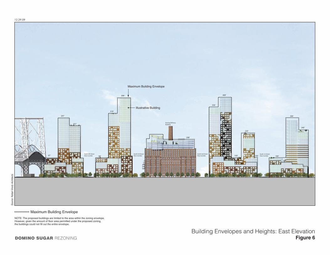
PROPOSED DEVELOPMENT PROGRAM
If approved, the proposed actions would allow for the construction of new residential structures along four of the waterfront blocks between Grand Avenue and South 5th Street and a new residential structure on the upland block east of Kent Avenue between South 3rd and South 4th Streets (see Figures 4, 5, and 6). The buildings along Kent Avenue would range in height from approximately 60 to 110 feet and would include retail/commercial uses on the ground floor. Two of the buildings along the waterfront would reach heights of up to 300 feet and two would reach up to 400 feet. The buildings on the upland parcel would range generally from 58 to 90 feet, with one module rising to approximately 148 feet. Ground-floor retail/commercial uses would be located along both sides of Kent Avenue throughout the site. The three buildings which together comprise The Refinery and which are located on the central block of the development between South 2nd and South 3rd Streets would be reused and converted to a combination of residential, retail/commercial, and community facility uses. As noted above, the program for the reuse of the Refinery complex has not been finalized. The applicant proposes an addition of 3 and 4 floors to the roof of the Refinery complex to assist in meeting the project’s goals and objectives as discussed below in “Project Goals and Objectives”. LPC voted to approve the proposed addition and other minor alterations on June 24, 2008. LPC’s findings with respect to the appropriateness of the proposed alterations on the landmarked Refinery are contained in a Status Update Letter issued by LPC on June 26, 2008 but the actual Certificate of Appropriateness has not yet been issued.
Ground-floor retail/commercial uses would be located along both sides of Kent Avenue throughout the site and on the waterfront edges of the buildings on the waterfront parcel. Publicly accessible open space, including an esplanade along the waterfront that would connect to Grand Ferry Park to the north of the site, would be constructed as part of the proposed project, as required by the Zoning Resolution. Additional open space beyond what is required by zoning would be developed between the Refinery complex and the waterfront. A total of approximately 4 acres of public open space would be provided on the project site.
As each site along the waterfront is built out, the associated public open space required under the Zoning Resolution would be completed at the same time as the buildings. It is expected that the esplanade and adjoining passive and active recreation areas as well as the 1-acre lawn adjacent to the Refinery would be owned, maintained, and operated by the New York City Department of Parks and Recreation (DPR) with the exception of a buffer of up to 10-feet around the buildings to allow for routine building maintenance activities.
It is anticipated that the development could be served by water taxi service and/or shuttle bus service to transit locations, and the implementation of these would be explored as demand is created by the proposed project’s development. While the project could accommodate a water taxi service, it would require its own USACE/NYSDEC approval process for dock designs and operations, which are unknown at this time. Additionally, other site plan and open space plan approvals by CPC may be required to accommodate the passenger dock. For EIS impact analyses, it is conservatively assumed that neither the water taxi nor the shuttle buses would be in place.
The proposed actions would facilitate a proposal by the applicant to develop approximately 2.81 million gsf of development above grade, including the reuse of the Refinery complex. As shown in Table 1, approximately 2.44 million gsf would be dedicated to residential use, up to 127,537 gsf to retail/commercial use, up to 146,451 gsf to community facility use, and up to 98,738 gsf to commercial office space. The applicant currently intends to build 2,200 residential units on the

100’ 100’ 97’Grand StreetView Corridor
South 2nd StreetView Corridor
350’
208’
400’
220’
South 1st StreetView Corridor
300’
240’
100’
257’
297’
South 4th StreetView Corridor
319’
399’
99’South 3rd StreetView Corridor
Building
Building Envelopes and Heights: West ElevationFigure 5DOMINO SUGAR REZONING
Sour
ce: R
afae
l Vin
oly
Arch
itect
s
12.29.09
Maximum Building Envelope
Illustrative Building
Maximum Building EnvelopeNOTE: The proposed buildings are limited to the area within the zoning envelope.However, given the amount of floor area permitted under the proposed zoning,the buildings could not fill out the entire envelope.
97’
257’
297’
319’
208’
399’
99’South 4th StreetView Corridor
South 3rd StreetView Corridor
Building
South 2nd StreetView Corridor
South 1st StreetView Corridor
350’
400’
220’
100’ 100’
300’
240’
100’
Building Envelopes and Heights: East ElevationFigure 6DOMINO SUGAR REZONING
Sour
ce: R
afae
l Vin
oly
Arch
itect
s
12.29.09
Maximum Building Envelope
Illustrative Building
NOTE: The proposed buildings are limited to the area within the zoning envelope.However, given the amount of floor area permitted under the proposed zoning,the buildings could not fill out the entire envelope.
Maximum Building Envelope

Final Scope of Work
9
project site, of which 660 would be affordable to low- and moderate-income households. However, it is assumed for analysis purposes in the DEIS that the project could include up to 2,400 residential units (based on an average unit size of approximately 1,000 gsf), 30 percent of which would be affordable to low- and moderate-income households. Although in order to realize the full allowable floor area under the proposed rezoning action, the applicant would be required to allocate 20 percent of the residential floor area as affordable housing, the EIS has assumed 30 percent because it is the applicant's stated intention to provide the 30 percent allocation.
There would also be 1,694 accessory parking spaces located on the project site in below-grade parking.
Table 1 Proposed Development Program
Site A Site B Refinery Site C Site D Site E TOTAL Residential
gsf 203,984 761,727 260,522 576,893 320,742 318,437 2,442,305 Total units 206 740 241 569 317 327 2,400*
Retail gsf 30,000 10,769 30,143 10,775 9,850 36,000 127,537
Commercial Office gsf 98,738 -- -- -- -- -- 98,738
Community Facility gsf 42,316 -- 104,135 -- -- -- 146,451
Total Floor Area gsf 375,038 772,496 394,800 587,668 330,592 354,437 2,815,031
Parking Spaces 782 - 127 411 - 374 1,694 Notes: gsf=gross square feet.
*The number of residential units is estimated based on an average unit size of approximately 1,000 gsf.
In addition to 203,984 gsf of residential space and approximately 30,000 gsf of retail space, Site A would include approximately 42,316 gsf of community facility space and 98,738 gsf of commercial office space. The portions of Site A that rise to elevations above the height of the nearby New York Power Authority (NYPA) facility exhaust stack would be limited to commercial office and potentially community facility use, and residential use on Site A would be located on the lower floors only. Due to the proximity of this site to the NYPA plant, commercial and community facility uses, which can operate with sealed windows, are appropriate at tower elevations above 110 feet. Residential uses will be located at the lower elevations of the buildings on Site A, where there is no need for a sealed-window condition. A sealed-window condition is not required at any site other than Site A.
PROJECT GOALS AND OBJECTIVES
Consistent with the abovementioned recently adopted zoning changes in the area of the Williamsburg waterfront and in keeping with the mission of CPC Resources, the proposed project seeks to meet the following objectives:
• In accordance with CPC Resources’ mission, and to address community concerns that affordable housing is still not achievable for existing working-class residents of Williamsburg, the proposed project will offer 30 percent of the development’s total units as affordable, with a portion of those units affordable to households with income levels

Domino Sugar Rezoning
10
reaching as low as 30 percent AMI. This goal exceeds the low-income incentive zoning requirements of the Greenpoint-Williamsburg Rezoning and provides affordable units at income levels substantially lower than those required by the Greenpoint-Williamsburg rezoning. The balance of the proposed project’s residential units would be market rate and would serve to cross-subsidize the substantial affordable housing component, which cannot be financed solely through existing government subsidy programs;
• Creation of physical and visual access to the waterfront, including a substantial amount of publicly accessible open space and a public waterfront esplanade with a linkage to the existing Grand Ferry Park to the north of the project site;
• Redevelopment of a former waterfront industrial site into an economically integrated mix of residential, retail/commercial, and community facility uses consistent with the redevelopment of nearby waterfront sites to the north and south and complementary to the existing neighborhood; and
• Reuse of the three buildings comprising the structure known as the Refinery.
PURPOSE AND NEED OF THE PROPOSED ACTIONS
PROJECT SITE
The proposed zoning map change on the project site is required to permit the development of residential, retail/commercial, and community facility uses for the proposed project. The proposed General Large Scale Plan, including waivers of height and setback requirements, is needed in order to redistribute floor area across the entire project site, including both the waterfront and upland parcels, thereby creating a site plan and building layout and design superior to what would be allowed as-of-right under the proposed zoning districts. In order to promote the creation of affordable housing on the project site, the proposed zoning text amendments to ZR 23-953, 62-35, 62-352, and Appendix F of the ZR are proposed to apply the inclusionary housing program. The proposed modification of waterfront access requirements would serve to facilitate an improved open space plan compared to what could be developed as-of-right. The proposed authorization for phased implementation of waterfront access requirements would ensure the orderly development of the project site and the CPC chair certification for waterfront public access and visual corridors would serve to assure compliance with all applicable design controls. As the project site is within the City’s Waterfront Revitalization Program boundaries, a Coastal Zone Consistency determination is necessary.
The area east of the project site hosts a mix of industrial and residential uses. Three full and partial blocks immediately east of the project site are zoned M3-1 and are occupied by a variety of light industrial and commercial uses. Recent land use trends suggest that new heavy manufacturing is unlikely on sites remaining in this M3-1 area. M3 districts have increased performance standards near residential districts to minimize potential impacts on residential uses. These include a requirement that all manufacturing uses be fully enclosed within 300 feet of a residential district. This enclosure requirement would apply to all three of the full or partial blocks if the proposed rezoning were approved.
FRAMEWORK FOR ANALYSIS
Construction of the proposed project is expected to occur between 2011 and 2020. Development anticipated to occur by 2020 as a result of the Greenpoint-Williamsburg rezoning as presented in

Final Scope of Work
11
the May 2005 Greenpoint-Williamsburg Rezoning Final Environmental Impact Statement (FEIS) will be considered as part of the No Action condition in this analysis and will be updated based on current field surveys and development proposals for the land use study area. The EIS analysis for each of the technical areas will examine the proposed project’s development program based on the land uses, building configurations, and site plans that would be allowed under the proposed actions and the proposed project.
Absent the proposed actions, the applicant intends to develop the project site with uses permitted under the existing M3-1 zoning. As shown on Figure 7, the future without the proposed project scenario includes the retention of the Refinery complex, which would be maintained but would remain vacant due to the high cost of adaptive reuse, the development of a storage facility on the waterfront parcel between South 3rd and South 5th Streets, a building materials storage yard along the waterfront to the north of South 2nd Street, and a new distribution facility along the waterfront immediately south of Grand Ferry Park. On the upland portion of the site, a new 2-story building with a catering hall/restaurant on the upper floor and parking on the ground floor would be constructed. The Boiler House, which is located between the Refinery and the waterfront, would also remain as a vacant building due to the high cost of demolition. Under the future without the proposed actions scenario, all buildings on the site except for the Refinery and the Boiler House would be demolished. The total development program for this scenario includes approximately 106,300 square feet (sf) of industrial distribution space, approximately 60,000 sf of storage space, 40,000 sf of catering hall/restaurant space, and 61,000 sf of land used for maritime industrial use (as well as 5,000 sf of office space for this use).
The assessment of impacts in the DEIS will be based on the incremental effects of the proposed project as compared to development under the No Action condition.
ENVIRONMENTAL REVIEW PROCESS
The Department of City Planning (DCP) as lead agency in the environmental review has determined that the proposed actions and project have the potential to result in significant environmental impacts and, therefore, pursuant to CEQR procedures, has issued a positive declaration requiring that an EIS be prepared in conformance with all applicable laws and regulations, including SEQRA, the City’s Executive Order No. 91, CEQR regulations (August 24, 1977) and the guidelines of the CEQR Technical Manual.
As noted above, a Draft Scope was prepared and issued for public review, and oral and written comments were accepted at a public hearing and through the public review period, which ended August 10, 2007. This Final Scope has been prepared to incorporate those relevant comments and will serve as the framework for the preparation of the DEIS.
Once DCP has determined that the DEIS is complete, it will be subject to additional public review, in accordance with the CEQR and ULURP processes, with a public hearing and a period for public comment. An FEIS will then be prepared to respond to those comments. The lead agency will make CEQR findings based on the FEIS, before making a decision on project approval.
As described in greater detail below, the EIS will contain:
• A description of the proposed actions and project and its environmental setting; • An analysis of the environmental impacts;

GRAND FERRY PARK
GRAND FERRY PARK
KENT AVENUE
SOU
TH 4
TH S
TREE
T
SOU
TH 5
TH S
TREE
T
SOU
TH 3
RD S
TREE
T
WIL
LIA
MSB
URG
BRI
DG
E
SOU
TH 2
ND
STR
EET
SOU
TH 1
ST S
TREE
T
GRA
ND
STR
EET
10.14.08
Future without the Proposed Project DevelopmentFigure 7DOMINO SUGAR REZONING
N
NOT TO SCALE
E A S T R I V E R
Sour
ce: R
afae
l Vin
oly
Arch
itect
s, P
C

Domino Sugar Rezoning
12
• A description of mitigation measures proposed to eliminate or minimize adverse environmental impacts;
• An identification of any adverse environmental effects that cannot be avoided if the proposed project is implemented;
• A discussion of alternatives to the proposed actions and project; and • A discussion of any irreversible and irretrievable commitments of resources to develop the
project.
C. ENVIRONMENTAL IMPACT STATEMENT SCOPE OF WORK
TASK 1: PROJECT DESCRIPTION
This opening chapter of the EIS introduces the reader to the proposed actions and provides the project description from which impacts are assessed. The chapter will contain a project identification; the background and purpose and need for the proposed project and any related actions; a detailed description of the proposed actions, the tax blocks and lots that are affected, and the proposed development program; diagrams to depict the proposed project, a description of any proposed landscaping and streetscapes; and a discussion of the approvals required.
The project description will include appropriate data from the ULURP application and a graphic presentation of key project elements, such as a site plan, elevations, parking, and circulation plans. The section on required approvals will describe all public actions required to develop the project, including zoning changes and any necessary special permits. Any need for environmental requirements—e.g., (E) designations—as part of the proposed rezoning action will be described.
TASK 2: ANALYTICAL FRAMEWORK
This chapter will establish the analytical framework for the analyses included in the EIS. This chapter provides decision-makers and the public a framework from which to evaluate the proposed project against both Build and No Build options. It will describe No Build conditions on the project site as well as a list of other projects anticipated to be built in the study area by 2020, including projected and potential developments as presented in the Greenpoint-Williamsburg Rezoning FEIS.
This chapter will also describe the project review schedule and the ULURP process. The role of DCP as lead agency for CEQR will be described as well as the purpose of the EIS as a full disclosure document to aid in decision-making.
TASK 3: LAND USE, ZONING, AND PUBLIC POLICY
The proposed project would directly affect the land use on approximately 11 acres of land on the East River waterfront and most of an adjacent upland block in Williamsburg. This chapter will analyze the potential impacts of the proposed project on land use, zoning, and public policy. The land use study area will consist of the project site and neighboring areas within a ½-mile radius of the site of the proposed actions. This assessment will also provide a baseline for other analyses in the EIS. The chapter will:
• Provide a brief development history of the project site and study area. • Describe conditions on the project site, including existing uses and the current zoning.

Final Scope of Work
13
• Describe predominant land use patterns in the study area, including recent development trends. Study areas will be the blocks immediately surrounding the project site and land uses within approximately ½ mile (see Figure 8).
• Provide a zoning map and discuss existing zoning and recent zoning actions in the study area.
• Summarize other public policies that may apply, such as the New York City Waterfront Revitalization Program, the Greenpoint-Williamsburg rezoning, and the Williamsburg Waterfront 197-a Plan.
• Describe the effects of projects anticipated to be built in the study area by 2020 on land use patterns and development trends. Also, describe pending zoning actions or other public policy actions that could affect land use patterns and trends in the study area, including plans for public improvements.
• Describe the proposed actions, the proposed project, and its development program. Provide an assessment of the impacts of the proposed project and anticipated development on land use and land use trends, zoning, and public policy. Present a map of the proposed zoning changes. Examine the effects related to issues of compatibility with surrounding land use, consistency with zoning and other public policy initiatives, including PlaNYC, and the effect of the project on development trends and conditions in the area. Policies regarding the waterfront revitalization program, coastal zone management, and historic resources will be discussed in their relevant sections.
TASK 4: SOCIOECONOMIC CONDITIONS
This chapter will examine the effects of the action on socioeconomic conditions in the study area, including population characteristics, increase in economic activity, and the potential displacement of residents, businesses and employment from the proposed action area. The analysis will follow the guidelines set forth in the CEQR Technical Manual for assessing the proposed actions’ effects on socioeconomic conditions within ¼- and ½-mile study areas (see Figure 9). According to the CEQR Technical Manual, the five principal issues of concern with respect to socioeconomic conditions are whether a proposed action would result in significant impacts due to: (1) direct residential displacement; (2) direct business and institutional displacement; (3) indirect residential displacement; (4) indirect business and institutional displacement; and (5) adverse effects on a specific industry.
In conformance with the CEQR Technical Manual guidelines, the assessment of these five areas of concern will begin with a preliminary screening analysis. As stated below, indirect residential displacement is the only area of socioeconomic impact that is likely to require a detailed analysis.
DIRECT BUSINESS AND RESIDENTIAL DISPLACEMENT
Because the project site is currently unoccupied, the proposed actions would not result in direct business or residential displacement. Therefore, the analyses of socioeconomic effects of direct business and residential displacement are not required under the CEQR Technical Manual.
INDIRECT BUSINESS DISPLACEMENT
In most cases, the issue of indirect displacement of businesses or institutions arises when an action would increase property vales and thus rents throughout the study area, making it difficult

EA
ST
RI V
ER
S. 1ST ST.
GRAND ST.
METROPOLITAN AVE.
N. 3RD ST.
N. 4TH ST.
N. 5TH ST.
N. 6TH ST.
N. 7TH ST.
KENT AVE.
WYTH
E AVE.
BERRY ST.
BEDFORD AV
E.
DRIGGS AV
E.
ROEBLING S
T.
HAVEMEYER S
T.
BQE
S. 2ND ST.
S. 3RD ST.
S. 4TH ST.
GRAND
S. 5TH ST.
S. 6TH ST.
WILLIAMSBURG BRIDGE
S. 8TH ST.
BROADWAY
S. 9TH ST.
S. 10TH ST.
S. 11TH ST.
DIVISION AVE.
MORTON ST.
CLYMER ST.
TAYLOR ST.
WYT
HE A
VE.
8.1.
08
Land Use Study AreaFigure 8DOMINO SUGAR REZONING
N
Project Site Boundary
Study Area Boundary (1/2-Mile Perimeter)SCALE
0 1000 FEET

WILLIAMSBURG BRIDGE
EA
ST
RI V
ER
1
2
3
1
1
3
3
2
1
5
4
1
2
2
1
3
4
2
2
2
5
4
1
3
1
2
2
529
577
519
551
549
557
555
553
523
547
535
525
KE
NT
AV
E.
WY
TH
E A
VE
.
S 3 ST.
S 4 ST.
BE
RR
Y S
T.
S 2 ST.
S 1 ST.
N 5 ST.
N 6 ST.
BED
FOR
D A
VE.
N 7 ST.
DR
IGG
S AV
E.
N 8 ST.
N 10 ST.
N 9 ST.
N 4 ST.
N 12 ST.
N 1 ST.
N 11 ST.
KEAP ST.
N 3 ST.
S 5 ST.
GRAND ST.
DIVISION AVE.
S 8 ST.
LEE AVE.
S 9 ST. MA
RC
Y A
VE
.
S 6 ST.
ROSS ST.
METROPOLITAN AVE.
HOOPER ST.
N 15 ST.
HAV
EM
EY
ER
ST.
CLYMER S
T.
WILS
ON ST.
N 14 ST.
BA
NK
ER
ST.
N 13 ST.
TAYLOR S
T.
S 10 ST.
HOPE ST.
RIV
ER S
T.
S 11 ST.
BORINQUEN PL
RO
EB
LIN
G S
T.
BROADWAY
RODNEY ST.
FR
AN
KLI
N S
T.
MORTON ST.
RUSH ST.
NASSAU AVE.
FILLMORE PL
HO
WLE
Y S
T.
MORTON ST.
S 5 ST.
HAV
EMEYER
ST.
RO
EB
LIN
G S
T.
S 1 ST.
S 2 ST.
S 9 ST.
MARCY AVE.
RO
DN
EY
ST.
BQ
E
BE
DFO
RD
AV
E
BROADWAY
Socioeconomic Conditions Study AreasFigure 9
N
SCALE
0 1000 FEET
8.1.
08
DOMINO SUGAR REZONING
Project Site Boundary
1/4-Mile Perimeter
1/4-Mile Study Area
1/2-Mile Perimeter
1/2-Mile Study Area Boundary
Census Tract Number
Census Tract Boundary
Study AreaCensus Block Group Number
Study AreaCensus Block Group Boundary
535
4

Domino Sugar Rezoning
14
for some categories of businesses to remain in the area. According to the CEQR Technical Manual, commercial development of 200,000 sf or less or residential development of fewer than 200 units would typically not result in significant indirect displacement. The proposed actions would introduce less than 200,000 sf of commercial development, but would introduce a substantial amount of new residential uses, and therefore, a preliminary assessment will be conducted to determine whether the proposed project could lead to significant indirect business displacement.
Using the most recent available data from public and private sources such as the New York State Department of Labor, the US Census Bureau, and ESRI, Inc., the preliminary assessment will describe existing economic activity in the study area, including the number and types of businesses and institutions and employment by key sectors. The analysis will also describe characteristics of the existing commercial and manufacturing buildings in the study area, based on visual inspections, RPAD data, local real estate listings, and discussions with local real estate brokers. In accordance with CEQR Technical Manual guidelines, the analysis will use this data to consider whether the proposed actions would have the potential to result in significant indirect business or institutional displacement impacts by altering existing economic patterns in the study area or by altering or accelerating an ongoing economic trend.
INDIRECT RESIDENTIAL DISPLACEMENT
In accordance with the guidance presented in the CEQR Technical Manual, the detailed analysis for indirect residential displacement will be organized into three components: existing conditions, future without the proposed actions (2020), and future with the proposed actions (2020).
Existing Conditions Demographic and economic studies and field investigations will be used to describe existing population and housing conditions in the proposed project area and within the ¼- and ½-mile study areas.
Tasks include:
• Provide current and trend information on population, households, income, and age, based on Census data from 1990 and 2000. Data from the New York City Department of Finance’s Real Property Assessment Database (RPAD) will be used to update the census population to reflect new development in the study area since 2000.
• Discuss housing characteristics, including trends in rents, sales prices, vacancy, and tenure, based on Census data and discussions with local real estate firms.
• Identify populations at risk of displacement by determining the portion of the population below the poverty level and the portion with income levels that are lower than the median for Brooklyn, and the portion of the population living in units not protected by rent control, rent stabilization, or other rent regulated programs.
Future Without the Proposed Actions In conjunction with the land use task, specific development projects that would occur in the ½-mile study area in the future without the proposed actions will be identified. Residential and commercial development forecast in the study area in the Greenpoint-Williamsburg Rezoning FEIS by 2020 will be considered part of the No Build condition. Changes in population and housing characteristics likely to occur as a result of these actions will be characterized,

Final Scope of Work
15
including: potential increases in population and demographic characteristics of the study area; new residential developments; and changes in rents or sales prices of residential units.
Future With the Proposed Actions/Potential Impacts Following the guidelines of the CEQR Technical Manual, the analysis of indirect residential displacement will use study area data (presented in existing conditions) to determine whether the proposed actions would have a significant adverse indirect residential displacement impact. If the proposed action introduces or accelerates a trend of changing socioeconomic conditions, and if the study area contains a population at risk, then the action may have a significant adverse impact. This analysis will take into account the housing units and population at risk as well as the affordable housing that would be provided as part of the proposed project.
SPECIFIC INDUSTRIES
Based on the guidelines in the CEQR Technical Manual, the preliminary analysis for effects on specific industries will respond to the following issues:
• Whether the proposed action would significantly affect business conditions in any industry or category of businesses within or outside the study area.
• Whether the proposed action would substantially reduce employment or impair viability in a specific industry or category of businesses.
TASK 5: COMMUNITY FACILITIES AND SERVICES
The demand for community facilities and services is directly related to the type and size of the new population generated by development resulting from the proposed action. New workers tend to create limited demands for community facilities and services, while new residents create more substantial and permanent demands. Community facilities other than open space (see Task 5) will be examined in this task.
In accordance with thresholds established in the CEQR Technical Manual, the number and type of new residential units expected to be developed as a result of the proposed actions would trigger detailed analyses of potential impacts on public schools, libraries, outpatient health care facilities, and publicly funded day care centers.
The City’s Police and Fire Departments routinely evaluate the need for changes in personnel, equipment, or facilities based on population, response times, crime levels, or other local factors. Therefore a detailed assessment of service delivery is usually conducted only if a proposed action would directly affect the physical operations of a station house or precinct house. Since the proposed actions would not directly affect existing police and fire protection facilities, a detailed assessment is not warranted. Fire and police facilities serving the area will be identified and located on a map and available data regarding fire and Emergency Medical Services (EMS) response times will be provided.
The proposed study area for community facilities would be defined as ½ mile from the proposed action area, but may vary by facility type in accordance with CEQR Technical Manual guidelines. The following analyses will be performed:
• Educational Facilities. Identify and locate public schools serving the project site. Assess conditions within the ½-mile study area and the local school district as a whole in terms of enrollment and utilization during the current school year, noting any specific shortages of
Domino Sugar Rezoning
16
school capacity. Identify conditions that will exist in the future without the proposed project, taking into consideration projected changes in future enrollment and plans to alter school capacity either through administrative actions on the part of the NYC Department of Education or as a result of the construction of new school space. Analyze future conditions with the proposed project, adding students likely to be generated by the project to the projections for the future without the action. Impacts of the proposed project will be assessed based on the difference between conditions in the future without the proposed actions and the future with the proposed actions in the 2020 analysis year.
• Libraries. Identify the local public library branch(es) serving the area. Describe existing population served by the branch(es), using information gathered for socioeconomic conditions assessment, information services provided by branch(es), circulation, level of utilization, and other relevant existing conditions. Details on library operations will be based on publicly available information and/or consultation with library officials. For No Build conditions, projections of population change in the area and information on any planned changes in library services or facilities will be described and the effects of these changes on library services will be assessed qualitatively. The effects of the addition of the population resulting from the proposed project will be qualitatively assessed in terms of special programs, facilities, and collections, with input from library branch management staff.
• Health Care Facilities. Identify hospital emergency room services and outpatient ambulatory care facilities (regulated by the NYS Department of Health and Office of Mental Health) within approximately one mile of the project site. Describe each facility in terms of its address, the type of service provided, an indicator of its size, capacity or utilization, and any other relevant existing conditions based on publicly available information and/or consultation with health care officials. For No Action conditions, the projected change in the area’s low/moderate-income population and any planned changes in health care facilities or services will be described and the effects of these changes on the operating capacity of the facilities will be assessed. The potential effects on health care facilities of the additional population resulting from the proposed project will be assessed in comparison with the effects of changes projected to occur in the future without the proposed project.
• Day Care Facilities. Identify existing public day care and head start facilities within approximately 1½ miles of the project site. Describe each facility in terms of its location, ages served, number of slots (capacity), existing enrollment and length of waiting list. Information will be based on publicly available information and/or consultation with the Administration for Children’s Services (ACS). In the future without the proposed actions, information will be obtained on any changes planned for day care programs and facilities within the area. Any projected increases in the number of children under 6 within the income eligibility limitations will be assessed as potential additional demand. The potential effects on day care facilities of the additional children resulting from the proposed project will be assessed in comparison with the effects of changes projected to occur in the future without the proposed actions.
The study areas for each of the above analyses are shown in Figure 10.
TASK 6: OPEN SPACE
New residents and workers brought to the area by the proposed project would place added demands on existing open space and recreational facilities. The proposed project would generate more than the CEQR threshold of 200 residents and 500 employees, thereby requiring further

BQE
2 AV
MYRTLE AV
DE KALB AV
KEN
T AV
3 AV
FLUSHING AV
LAFAYETTE AV
WYTH
E AV
GREENE AV
E 10 ST
LORIM
ER ST
PARK AV
DRIG
GS
AV
E 4 ST
LEON
ARD
ST
F D R
DR
5 AV
E 12 ST
AV A
GR
AHAM
AV
AV B
E 3 STE 2 ST
BER
RY
ST
THR
OO
P AV
QUINCY ST
E 14 ST
BOW
ERY
N 6 ST
HART ST
S 2 ST
LEXINGTON AV
LEE AV
N 5 ST
N 8 ST
S 1 ST
KING
SLAND
AV
N 7 ST
NASSAU AV
S 3 ST
LEWIS AV
GATES AV
HENRY ST
BUSH
WIC
K AV
N 11 ST
JAY
ST
KEAP
ST
FULTON ST
DEVOE ST
4 AV
MO
RG
AN AV
N 12 ST
N 9 ST
S 4 ST
VERNON AV
JAVA ST
PENN ST
PULASKI ST
CLIFTON PL
S 5 ST
MO
NITO
R ST
INDIA ST
TOM
PKINS AV
N 4 ST
KENT ST
CLIN
TON
AV
SOUTH ST
ADELPH
I ST
N 10 ST
WASH
ING
TON
AV
DIVISION AV
KOSCIUSZKO ST
NO
STRAN
D AV
YORK ST
SCHOLES ST
FRAN
KLIN ST
RU
SSELL ST
CLI
NTO
N S
T
FRONT ST
ALLE
N S
T
S 8 ST
N 3 ST
POWERS ST
N 1 ST
HURON ST
MC G
UINNESS BLVD
GREENPOINT AV
CLER
MO
NT AV
AINSLIE ST
HOO
PER
ST
LYNCH ST
MESEROLE ST
WILLOUGHBY AV
E 1 ST
NEWEL ST
GREEN ST
FRAN
KLIN AV
CANAL ST
VAND
ERBILT AV
SKILLMAN AV
WAVER
LY AV
JOHN ST
METROPOLITAN AV
TAAFFE PL
SKILLMAN
ST
ROSS ST
HEYWARD ST
HEWES ST
RUTLEDGE ST
S 9 ST
NAV
Y S
T
CO
URT
ST
HARRISON AV
CLAY ST
MAR
CU
S GAR
VEY BLVD
MONTROSE AV
E 21 ST
E 8 ST
MONROE ST
FLATBUSH
AV EX
5 ST
CAR
LTON
AV
JEWEL ST
FOR
SYTH
ST
TILLARY ST
DIAMO
ND ST
EAGLE ST
CONSELYEA ST
BAYARD ST
S 6 ST
N H
ENR
Y ST
WILLOUGHBY ST
BROOKLYN BR
UN
ION
AV
NOBLE ST
MIDDLETON ST
W 17 ST
MASPETH AV
BR
IDG
E S
T
N 15 ST
8 ST
PRO
VOST ST
HU
MBO
LDT ST
DUPONT ST
NASSAU ST
CLYMER ST
WALTON ST
APOLLO
ST
FREEMAN ST
SUTTO
N ST
ST MARK'S PL
WILSON ST
BANKER ST
PULASKI BR
E 13 ST
SPRING ST
EMER
SON
PL
BOX ST
ELLERY ST4 ST
1 AV
OLI
VE
ST
N 14 ST
MILTON ST
GUERNSEY ST
OAK ST
MAR
CY A
V
HOPKINS ST
E 15 ST
BORINQUEN PL
MARKET ST
N 13 ST
PROSPECT ST
W 18 ST
SAND
FOR
D ST
DOBBIN ST
WES
TWAY
HAU
SMAN
ST
GO
LD S
T
BOND ST
PAIDGE AV
WES
T ST
S 10 ST
MO
ULTRIE ST
CAD
MAN
PLZ W
JAY AV
COMMERCIAL ST
2 ST
HOPE ST
BARTLETT ST
RIVER
ST
ASH ST
RICHARDSON ST
RU
TGER
S ST
LAW
RE
NC
E S
T
S 11 ST
AS
SE
MB
LY R
D
7 AV
WO
ODP
OIN
T RD
EAST
WAY
TEN EYCK ST
QUAY ST
MADISON ST
WHIPPLE ST
NEWTON ST
RO
EBLI
NG
ST
WASH
ING
TON
PARK
W 19 ST
WA
SH
ING
TON
ST
ORIENT AV
FDR DR NB EN BK BR
WAR
SOFF PL
WYCKOFF ST
RYER
SON
ST
GREAT JONES ST
PE
AR
L S
T
LOVE LA
CO
OPE
R S
Q
VINE ST
29 ST
JACKSON ST
JUD
GE ST
PERRY AV
S 5
PL
JOHNSON ST
CLIFFORD PL
JONES AL
WYTHE PL
RUSH ST
SPENC
ER C
T
30 ST
1 AV
E 23 ST
STAGG ST
CLIN
TON
STHOOPER ST
HEW
ES S
T
WILLOUGHBY AV
E 5 ST
HEWES ST
OAK ST
BRO
ADW
AY
GREENPOINT AV
WILSON STSEIGEL ST
WAVER
LY AV
MORTON ST
E 15 ST
E 16 ST
WATER ST
WATER ST
FROST ST
SOUTH ST
UN
ION
AV
PE
AR
L S
T
ROEBLING S
T
2 ST
BQE
DU
FFIE
LD S
T
COOK ST
MC KIBBIN ST
F D R DR
CAT
HE
RIN
E S
T
3 AV
MANHATTAN BR
BROOME ST
E 13 ST
JACKSON ST
RAMP
VARET ST
WEST ST
BR
IDG
E S
T
WATER ST
2 S
T
S 3 ST
S 4 ST
MYRTLE AV
HU
DS
ON
AV
METROPOLITAN AV
KENT AV
WITHERS ST
GRAND ST
HOPE STM
ARCY
AV
KEAP ST
N HE
NRY
ST
ELLERY ST
HAVEMEYER S
T
E 16 ST
GRAND ST
RODNEY ST
GO
LD S
T
FROST ST
MOORE ST
HALL ST
TAYLOR ST
FOR
SYTH
ST
S 9 ST
WILLIAMSBURG BR
UN
ION
AV
BROADWAY
UN
ION
AV
AD
AM
S S
T
E 5 ST
S 5 ST
MAUJER ST
EA
ST
RIV
ER
NEWTOWN CREEK
DOMINO SUGAR REZONING
12.2
9.09
SCALE
0 2000 FEET
Community Facilities Study AreaFigure 10
Project Site Boundary
Educational Facilities Study Area Boundary(1/2-Mile Perimeter)
Libraries Study Area Boundary(3/4-Mile Perimeter)
Health Care Study Area Boundary(1-Mile Perimeter)
Child Care and Head Start Study Area Boundary(1 1/2-Mile Perimeter)

Final Scope of Work
17
assessment of open space. The analysis will consider both passive and active open space resources, requiring two study areas—one that considers the supply and demand for passive open space required by the non-residential population in a ¼-mile study area and one that considers the supply and demand for both passive and active open space required by the residential population in a ½-mile study area (see Figure 11). A detailed open space analysis will be conducted and will include the following tasks:
• Using 2000 Census data and other data where applicable, calculate the total residential and employee population of the open space study area, which, as per CEQR guidelines, would be defined as the area within a ¼-mile and ½-mile distance for the residential analysis, with the study area boundary adjusted to include all census tracts with at least 50 percent of their area within these study areas.
• Inventory existing active and passive open spaces within the study areas. The condition and usage of existing facilities will be described based on the inventory and field visits. Jurisdiction, features, user groups, quality/condition, factors affecting usage, hours of operation, and access will be included in the description of facilities. Also, the potential for facilities to be affected by direct impacts, such as from shadows cast by the proposed project, will also be assessed. Acreage of these facilities will be determined and total study area acreage calculated. The percentage of active and passive open space will also be calculated.
• Based on the inventory of facilities and study area population, calculate the open space ratio for the residential and employee populations in the study areas and compare to City guidelines to assess adequacy. This is expressed as the amount of open space acreage per 1,000 user population. Open space ratios will be calculated for active and passive open space, as well as the ratio for the aggregate open space.
• Assess projected changes in future levels of open space supply and demand in the Analysis year, based on the No Action use of the project site and other anticipated development projects within the study area. Take account of any new open space and recreational facilities expected in the study area. This analysis will include new populations and open space as projected under the Greenpoint-Williamsburg Rezoning FEIS. Open space ratios will be developed for future conditions without the action and compared with existing ratios to determine changes in future levels of adequacy.
• Based on the residential and employee populations and open space acreage added by the proposed project, assess its effects on open space supply and demand. The assessment of proposed project impacts will be based on a comparison of open space ratios with the proposed project and open space ratios in the future without the proposed project for the ½-mile study area. In addition to the quantitative analysis, qualitative analysis will be performed to determine if the changes resulting from the proposed project will result in a substantial change (positive or negative) or an adverse effect to open space conditions.
• If the results of the impact analysis identify a potential for a significant adverse impact, discuss potential mitigation measures.
TASK 7: SHADOWS
ISSUES
This chapter will examine the proposed actions’ potential shadow effects pursuant to CEQR Technical Manual criteria. Generally, shadow impacts could occur if an action would result in

EA
ST
RI V
ER
S. 1ST ST.
GRAND ST.
METROPOLITAN AVE.
N. 3RD ST.
N. 4TH ST.N. 5TH ST.
N. 6TH ST.
N. 7TH ST.
N. 8TH ST.
N. 9TH ST. N. 10TH ST.
N. 11TH ST.
N. 12TH ST.
N. 13TH ST.
N. 14TH ST.
KENT AVE.
WYTH
E AVE.
BERRY ST.
BEDFORD AV
E.DRIG
GS AVE.
ROEBLING S
T.
HAVEMEYER S
T.
BQE
S. 2ND ST.
S. 3RD ST.
S. 4TH ST.
GRAND ST.
S. 5TH ST.
S. 6TH ST.
WILLIAMSBURG BRIDGE
S. 8TH ST.
BROADWAY
S. 9TH ST.
S. 10TH ST.
S. 11TH ST.DIVISION AVE.
MORTON ST.
CLYMER ST.
TAYLOR ST.
WYT
HE A
VE.
577
551
549
555
553
523
547525
Open Space Study AreasFigure 11DOMINO SUGAR REZONING
N
SCALE
0 1000 FEET
8.1.
08
DOMINO SUGAR REZONING
Project Site BoundaryCensus Tract NumberCensus Tract Boundary
1/4-Mile Perimeter1/4-Mile Study Area Boundary1/2-Mile Perimeter1/2-Mile Study Area Boundary
525

Domino Sugar Rezoning
18
new structures or additions to buildings resulting in structures over 50 feet in height that could cast shadows on natural features, publicly accessible open space, or on historic features that are dependent on sunlight. The proposed project would include the construction of four residential buildings along the waterfront, two with a maximum height of 300 feet and two with a maximum height of 400 feet, and residential buildings on the east side of Kent Avenue with heights of up to 148 feet. Thus, an analysis of shadows is appropriate.
An analysis of shadows will be prepared focusing on the relation between the incremental shadows created by the proposed project’s buildings (i.e., the additional shadow cast in the future with the proposed project as compared to the shadow that would be cast under the No Action condition) on any sun-sensitive landscape or activities in the open spaces on and near the project site. These analyses will include the following tasks:
• Identify sun-sensitive landscapes and historic resources within the path of the proposed project’s shadows. In coordination with a survey for the open space and historic analyses, map and describe any sun-sensitive areas. For open spaces, map active and passive recreation areas and features of the open spaces such as benches or play equipment. The East River, an important natural landscape, will be included in the shadows analysis.
• Prepare shadow diagrams for time periods when shadows from the new buildings could fall onto existing open spaces as well as open space created as a result of the project. The analysis will also take into account any historic resources identified in the area that may have significant sunlight dependent features such as stained glass windows. These diagrams will be prepared for up to four representative analysis days (March 21/September 21, May 6, June 21, December 21) if shadows from the proposed building would fall onto any of the open spaces or sun-sensitive historic resources on that day.
• Map the shadows from the existing buildings, No Action buildings, and the proposed project. Describe the effect of the incremental shadows from the proposed project on publicly accessible open spaces, project open spaces, and natural features, as well as any historic resources with significant sunlight dependent features based on the shadow diagrams for each of the analysis dates.
• Create a duration table that will show the entering and exiting times when an incremental shadow would fall on each affected open space or when an historic feature would be affected by a project-generated incremental shadow.
TASK 8: HISTORIC RESOURCES
The CEQR Technical Manual identifies historic resources as districts, buildings, structures, sites, and objects of historical, aesthetic, cultural, and archaeological importance. Historic resources include designated NYCLs and Historic Districts; properties calendared for consideration as NYCLs by LPC or determined eligible for NYCL designation; properties listed on the State and National Register of Historic Places (S/NR) or formally determined eligible for S/NR listing, or properties contained within a S/NR listed or eligible district; properties recommended by the New York State Board for listing on the S/NR; National Historic Landmarks (NHLs); and potential historic resources (i.e., properties not identified by one of the programs listed above, but that appear to meet their eligibility requirements).
On September 25, 2007, LPC designated three of the buildings on the project site as NYCLs. These buildings are the Filter, Pan, and Finishing Houses at 292-314 Kent Avenue (collectively referred to as the Refinery). In addition, as part of their determination of eligibility for the

Final Scope of Work
19
former American Sugar Refinery complex, the New York State Office of Parks, Recreation and Historic Preservation (OPRHP) has formally determined that all of the buildings on the portion of the project site located west of Kent Avenue are eligible for S/NR listing. Sugar processing began on the site in the mid-1850’s, and although much of the Refinery was destroyed by a fire in 1882, the buildings were quickly rebuilt. The buildings currently on the site date from the time of the rebuilding, beginning in 1882, to the mid-20th century. Between 1870 and 1914 sugar refining was the city’s most profitable manufacturing industry, and the American Sugar Refining Company was the most prominent of the sugar refining firms.
Because the proposed project would result in new in-ground disturbance and the alteration and/or demolition of existing buildings, it has the potential to result in impacts to archaeological and architectural resources. The following tasks will be undertaken as part of the historic resources analysis:
ARCHAEOLOGICAL RESOURCES
• Consult with LPC and OPRHP regarding the potential archaeological sensitivity of the project site. This review will serve as a basis in determining whether the site warrants further study.
• If LPC or OPRHP determines that the project site may be sensitive for archaeological resources, a Stage 1A Archaeological Assessment will be prepared for their review. The Stage 1A Archaeological Assessment will identify the potential for the project site to contain precontact-period and/or historic-period archaeological resources.
• Qualitatively discuss any impacts on potential archaeological resources that are expected in the future without the proposed project.
• Describe the proposed project and the potential impact it could have on archaeological resources through subsurface disturbance.
• If applicable, develop mitigation measures to avoid or minimize any adverse impacts on archaeological resources in consultation with LPC and OPRHP.
ARCHITECTURAL RESOURCES
• Within the study area—an area extending north of the project site to North 3rd Street, east to Bedford Avenue, and south to Broadway (see Figure 12)—map and briefly describe known architectural resources.
• Conduct a field survey of the study area to identify any potential architectural resources that could be impacted by the proposed project. Potential architectural resources comprise properties that appear to meet the eligibility criteria for NYCL designation and/or S/NR listing. Map and briefly describe any potential architectural resources.
• Qualitatively discuss any impacts on architectural resources that are expected in the future without the proposed project as a result of the No Action use of the project site and other anticipated development projects. This would include any projected or potential developments in the Greenpoint-Williamsburg Rezoning FEIS.
• Describe the proposed project and the impact it would have on the buildings on the project site. This could include the demolition of existing buildings and the preservation of buildings and other features. Assess the project’s potential for indirect impacts on any architectural resources in the study area (e.g., the Williamsburg Bridge, which has been determined eligible for listing on the SN/R), including visual and contextual impacts.

EA
ST
RI V
ER
S. 1ST ST.
GRAND ST.
METROPOLITAN AVE.
N. 3RD ST.
N. 1ST ST.
N. 4TH ST.
N. 5TH ST.
N. 6TH ST.
N. 7TH ST.
KENT AVE.
WYTH
E AVE.
BERRY ST.
BEDFORD AV
E.
S. 2ND ST.
S. 3RD ST.
S. 4TH ST.S. 5TH ST.
S. 6TH ST.
WILLIAMSBURG BRIDGE
S. 8TH ST.
BROADWAY
S. 9TH ST.
WYT
HE A
VE.
DRIG
GS A
VE.
ROEB
LING
ST.
HAVE
MEY
ER S
T.
S. 10TH ST.
S. 11TH ST.
DIVISION AVE.
Historic Resources Study AreaFigure 12 DOMINO SUGAR REZONING
N
Project Site Boundary
Study Area BoundarySCALE
0 1000 FEET
8.1.
08

Domino Sugar Rezoning
20
• Because the proposed project may involve state or federal funding or subsidies, or require state and federal permitting, potential impacts to historic resources will be evaluated in accordance with state and federal procedures.
• If applicable, develop mitigation measures to avoid any adverse impacts on architectural resources in consultation with LPC and, as appropriate, OPRHP.
TASK 9: URBAN DESIGN AND VISUAL RESOURCES
The proposed project would substantially alter the appearance of the project site and therefore has the potential to result in impacts related to urban design and visual resources. This analysis will consider the urban design effects of the proposed project on the character of the surrounding area. In addition, the analysis will consider the effects of the proposed project on views from the Williamsburg Bridge and along the East River. The study area for urban design and visual resources, including arrows showing the vantage points from which renderings of the proposed development will be produced, is shown in Figure 13.
This task will:
• Describe the project area and the existing urban design and visual resources of the study area, using photographs and text as appropriate. Views of the site from Manhattan and from the Williamsburg Bridge will be considered as well as views of the site along Kent Avenue and the east-west view corridors from South 5th Street to Grand Street.
• Describe the changes expected in the urban design and visual character of the study area that are expected in the future without the proposed project as a result of the No Action use of the project site and other anticipated development projects.
• Describe the visual character of the proposed development. Assess the anticipated changes in urban design and visual resources that would result from the proposed project in the study area and evaluate the significance of that change. This analysis would focus on public view corridors to the East River, view corridors along the river, and views from the public walkways on the Williamsburg Bridge.
• Describe potential wind conditions related to the proposed site plan and building massing.
TASK 10: NEIGHBORHOOD CHARACTER
Neighborhood character is established by a number of factors, such as land use, urban design, visual resources, historic resources, socioeconomic conditions, traffic, and noise. The proposed project could affect the character of the area by introducing a residential development including retail/commercial and/or community facility uses to a site previously used for manufacturing. This chapter of the document will explain those effects in a summary fashion.
Methodologies outlined in the CEQR Technical Manual will be used to provide an assessment of neighborhood character. Work items for this EIS task are as follows:
• Based on other EIS sections, describe the predominant factors that contribute to defining the character of the neighborhood surrounding the project site, which is marked by a mix of residential, industrial, and retail uses.
• Based on anticipated development projects, the No Action use of the project site, public policy initiatives, and anticipated public improvements, summarize changes that can be expected in the character of the area in the future without the proposed project. Recent and pending zoning actions, including the Greenpoint-Williamsburg rezoning adopted in May
EA
ST
RI V
ER
S. 1ST ST.
GRAND ST.
METROPOLITAN AVE.
N. 3RD ST.
N. 4TH ST.
N. 5TH ST.
N. 6TH ST.
N. 7TH ST.
KENT AVE.
WYTH
E AVE.
BERRY ST.
BEDFORD AV
E.
DRIGGS AV
E.
ROEBLING S
T. HAV
EMEYER ST.
BQE
S. 2ND ST.
S. 3RD ST.
S. 4TH ST.
GRAND
S. 5TH ST.
S. 6TH ST.
WILLIAMSBURG BRIDGE
S. 8TH ST.
BROADWAY
S. 9TH ST.
S. 10TH ST.
S. 11TH ST.
DIVISION AVE.
MORTON ST.
CLYMER ST.
TAYLOR ST.
WYT
HE A
VE.
Urban Design and Visual Resources Study AreaFigure 13 DOMINO SUGAR REZONING
N
Project Site Boundary
Study Area Boundary(1/2-Mile Perimeter)
SCALE
0 1000 FEET
8.1.
08
2
3
6
1
4
5
8
7
9*
East River State ParkEast River State Park
William SheridanPlaygroundWilliam SheridanPlayground
1 Photo Direction and Reference Number
View taken fromEast River Park/Manhattan
9*

Final Scope of Work
21
2005 and several smaller rezonings south of the Williamsburg Bridge, will contribute to substantial changes to neighborhood character in this area.
• Assess and summarize the proposed project’s impacts on neighborhood character using the analysis of impacts as presented in other pertinent EIS sections (particularly urban design, historic resources, socioeconomic conditions, noise, and traffic).
TASK 11: NATURAL RESOURCES
The project site lies on the East River waterfront and is mostly developed with shoreline protection measures. The EIS will provide an assessment of natural resources. Any existing natural resources within or in the vicinity of the proposed action area would be identified, including any significant fish habitats in this section of the East River. The proposed project’s potential impacts on identified natural resources would be assessed, including both short-term construction effects, as well as any potential long-term effects, including any new outfalls, expected run-off, etc. A discussion of any related permits that may be required would be provided.
This task will include the following:
• Describe the water quality conditions along the East River, including the trend and projection data, with site specific data as may be available through a literature review (e.g., the New York City Department of Environmental Protection (DEP) Harbor Survey). This section will also describe the general hydrodynamic characteristics of the East River, including currents, tidal range, water quality classification, and overall pollutant loads and chemical and biological conditions.
• Discuss East River water quality conditions and any potential impacts of the proposed project and evaluate the effects of any additional sanitary wastewater, stormwater or combined sewage overflows on East River water quality.
• Review currently available information on aquatic habitats in the study area. This effort will also be undertaken using published literature, including the identification of essential fish habitats. The presence of tidal wetlands will be based on existing New York State DEC tidal wetlands maps.
• There are no significant natural resources issues with respect to terrestrial flora or fauna. Therefore, the site will be characterized based on a review of aerial photography and a field investigation.
• The New York State Natural Heritage Program and the US Fish and Wildlife Service will be contacted to obtain data as to the potential presence of rare or endangered plant or animal species in the area and essential fish habitats, along the East River.
• A projection will be made of natural resources conditions through the 2020 analysis year based on anticipated future conditions without the proposed project.
• An assessment of potential impacts from the proposed project will be presented analyzing any changes in water coverage, sediment disturbance, water quality, fish, and bird habitats, and terrestrial resources. Impact issues could include additional flow from outfalls (see also Task 14, “Infrastructure,” below), improvements to bulkhead and platform conditions, and any cumulative impacts of the proposed project with respect to other East River waterfront projects to the north and south. Any potential impacts on rare or endangered species or essential fish habitats will be presented. The need for any State or Federal approvals will also be described.

Domino Sugar Rezoning
22
This analysis will also evaluate the potential for impacts due to any combined sewer overflow resulting from the proposed project (see also Task 14, “Infrastructure,” below).
TASK 12: HAZARDOUS MATERIALS
This section will examine the potential for impacts related to subsurface contamination, including an evaluation of the existing soil and groundwater conditions in areas that would be affected by the proposed project. It will summarize conditions on the sites based on a review of existing Environmental Site Assessments and reports on subsurface investigations. A detailed scope of work follows.
• The land use history of the rezoning area will be described based on an examination of historic maps, atlases, and other historical records.
• NYSDEC records and the City’s Fire and Building Department records will be examined for records of underground storage tanks.
• Records of other areas of environmental concern—including hazardous waste disposal sites, hazardous waste generators or treatment facilities, and hazardous substance releases—will be obtained through a computer database for all locations within a ½-mile of the site.
• Available information on subsurface conditions (geology and hydrogeology), including any borings performed on or near the site, will be obtained and reviewed.
• All available prior reports of soil or groundwater testing on or adjacent to the property will be reviewed.
• The site and the surrounding study area will be inspected for any evidence of contamination, including the presence of drums or tanks, stained soils, stressed vegetation, and illegally dumped or stored material.
• The potential for contamination of soil and groundwater in the rezoning area, and the need for any site testing, will be assessed based on land use history, examination of tank records, and current site conditions.
• The results of the assessment will be summarized for inclusion in the EIS. • If there is the potential for significant impacts under the proposed project, the need to
perform soil or groundwater sampling as mitigation will be described in the mitigation chapter as well as the need for any restrictive declaration to implement the mitigation.
TASK 13: WATERFRONT REVITALIZATION PROGRAM
The project site is located within the City’s coastal zone. This task will assess the project’s consistency with the City’s Local Waterfront Revitalization Program (LWRP). Adopted under the federal Coastal Zone Management Act of 1972, the LWRP is administered by CPC acting as the City Coastal Commission, and consists of 10 policies that address such issues as water dependency, flooding, erosion, natural resources, water quality, and public access.
TASK 14: INFRASTRUCTURE
The proposed project will place additional demands on the infrastructure systems serving the area. This section will analyze the demand for water and energy, and the generation of sewage and stormwater. This chapter of the EIS will include:
Final Scope of Work
23
WATER SUPPLY
• The existing water distribution system serving the project site will be described based on information obtained from the DEP’s Bureau of Water Supply and Wastewater Collection.
• Project water demand for the proposed project. The effects of the incremental demand on the City’s water supply system will be assessed to determine if there would be impacts to water supply or pressure. The incremental water demand will be the difference between the demand with the proposed project and the water demand of the site in the No Action condition.
STORM WATER AND SANITARY SEWERS
• Describe the existing sewer system serving the project area based on information obtained from DEP. The existing flows to the Newtown Creek Water Pollution Control Plant (WPCP) will be obtained for the latest 12-month period. The average annual monthly flow will be presented.
• Estimate sanitary sewage generation for the proposed project. The effects of the incremental demand on the system will be assessed to determine if there will be any impact on operations of the WPCP. The incremental sanitary sewage demand will be the difference between the demand with the proposed project and the sanitary sewage demand of the site in the No Action condition.
• The analysis will also include an examination of affects of the proposed project’s additional sanitary sewage flow on the number of and annual volume of combined sewer overflow events.
• The incorporation of Best Management Practices or other measures to control stormwater runoff from the project area will be discussed.
TASK 15: SOLID WASTE AND SANITATION SERVICES
The proposed project includes new development that would require sanitation services. This chapter will provide an estimate of the additional solid waste expected to be generated by the proposed project and assess its effects on the City’s solid waste and sanitation services.
• Describe existing and future New York City solid waste disposal practices, including the collection system and disposal methods.
• Estimate existing solid waste generation and solid waste generation in the future without the proposed project.
• Project solid waste generation by the proposed project based on CEQR guidelines. • Assess the impacts of the proposed project’s solid waste generation on the City’s collection
needs and disposal capacity. The assessment of impacts will be based on the proposed project’s incremental increase in solid waste generation as compared to the solid waste generated in the No Action condition.
TASK 16: ENERGY
According to the CEQR Technical Manual, actions resulting in new construction would not create significant energy impacts because all new structures requiring heating and cooling are subject to the New York State Energy Conservation Code, which reflects State and City energy policy. Therefore, a detailed energy assessment is not required. For CEQR analysis purposes,

Domino Sugar Rezoning
24
energy analysis focuses on an action's consumption of energy. This chapter will describe the energy systems that would supply the proposed project with electricity and/or natural gas. This will include descriptions of the capacity and existing demand of the entire systems, and of the distribution networks serving the project site.
TASK 17: TRAFFIC AND PARKING
The proposed actions would allow the development of a project with a substantial number of residential units as well as potential retail/commercial and community facility uses and waterfront open space. These uses would generate additional vehicular travel and increase demand for parking, as well as pedestrian traffic and subway and bus riders. These new trips have the potential to affect the area’s transportation systems. As the new uses would replace former manufacturing uses at the site, certain transportation demands formerly generated by the site’s uses would also be eliminated.
The traffic analysis under this task will be an important focus of the EIS and will examine 48 intersections and 37 intersections for the weekday and Saturday conditions, respectively, (see Figure 14a and 14b) for the potential for the proposed project to generate significant traffic impacts. In addition, the analysis will examine potential increases in the parking demand.
Recently, Kent Avenue has been reconfigured in terms of traffic flow direction and geometric configuration in the study area. Specifically, since late September/early October 2009 the traffic flow direction on Kent Avenue has been changed from a two-way north-south operation to a one-way northbound operation between Clymer and North 14th Streets. In addition to the traffic flow direction change, new northbound-southbound bicycle lanes were installed on the west side of Kent Avenue in October 2009. Other geometric changes for the reconfigured Kent Avenue include a new loading/unloading lane on the east side of the roadway, followed by a northbound moving lane of traffic and a floating parking lane that separates the moving traffic lane from the bicycle lanes.
The traffic patterns resulting from the reconfiguration of Kent Avenue have not yet stabilized. Further, DOT is planning to assess the efficacy of the new Kent Avenue configuration and to determine whether additional network modifications are needed. The DEIS will qualitatively assess the potential traffic impacts of the proposed project as they relate to the new configuration of Kent Avenue, and will include a detailed quantitative analysis of traffic conditions assuming two-way volumes on Kent Avenue. It should be noted that once the traffic patterns resulting from the reconfiguration of Kent Avenue have stabilized, a detailed quantitative analysis of traffic conditions resulting from reconfigured Kent Avenue will be performed between the DEIS and FEIS. This analysis will also address the reassignment of truck trips as a result of the Kent Avenue reconfiguration.
Based on preliminary estimates, the proposed actions are expected to generate more than 50 vehicular trips in the weekday AM, midday, and PM and Saturday midday peak hours (see Attachment A, “Transportation Planning Factors”). As the number of vehicle trips would exceed the 50 vph CEQR threshold requiring detailed analysis in all four of these periods, the EIS will analyze all peak periods in detail, focusing on those intersections handling the highest concentrations of peak hour project-generated demand. The assessment of impacts will be based on the incremental increase in travel demand with the proposed project (i.e., the difference between the travel demand with the proposed project and the demand under the No Action condition).

KENT AVE.
BQE
CNTG
HW
Y
S. 4TH ST.
FLUSHING AVE.
DRIGGS AV
E.
LEE AVE.
N. 8TH ST.
KEAP
ST.
N. 6TH ST.
N. 5TH ST.
N. 7TH ST.
N. 9TH ST.
MEEKER AVE
N. 4TH ST.
PENN ST.
METROPOLITAN AVE.
N. 1ST ST.
N. 3RD ST.
DIVISION AVE.
S. 8TH ST.
LYNCH ST.
HOOPER ST.
HEWES ST.
S. 9TH ST.
ROSS ST.
MAR
CY A
VE.
HEYWARD ST.
RUTLEDGE AVE.
RUTLEDGE ST.
S. 6TH ST.
HARRISON AVE.
MIDDLETON ST.
CLYMER ST.
WILSON ST.
FRAN
KLIN AVE.
SANFO
RD
ST.
SPENC
ER ST.
NO
STRAN
D AVE.
SKILLMAN
ST.
WALW
OR
TH ST.
TAYLOR ST.
S. 10TH ST.
BQE EXIT
NB
HOPE ST.
S. 11TH ST.BROADWAY
RODNEY ST.
MORTON ST.
RUSH ST.
DU
NH
AM P
L.
S. 2ND ST.
HEW
ES S
T.
FROST ST.
RODNEY ST.
KEAP ST.
S. 5TH ST.
RODN
EY S
T.
RE
VIR
TS
AE
KENT AVE.
CLASSO
N
AVE.
BQE
CNTG
HW
Y
S. 4TH ST.
FLUSHING AVE.
DRIGGS AV
E.BERRY ST.
WYT
HE
AVE.
BEDFORD AV
E.
BK Q
N E
XWY
CN
TG H
WY
WIL
LIAM
SBU
RG
ST.
W.
WIL
LIAM
SBU
RG
ST.
E.
LEE AVE.
N. 8TH ST.
KEAP
ST.
N. 6TH ST.
N. 5TH ST.
N. 7TH ST.
N. 9TH ST.
MEEKER AVE
N. 4TH ST.
PENN ST.
METROPOLITAN AVE.
N. 1ST ST.
N. 3RD ST.
DIVISION AVE.
S. 8TH ST.
LYNCH ST.
HOOPER ST.
HEWES ST.
S. 9TH ST.
ROSS ST.
MAR
CY A
VE.
HEYWARD ST.
RUTLEDGE AVE.
RUTLEDGE ST.
S. 6TH ST.
HARRISON AVE.
MIDDLETON ST.
CLYMER ST.
WILSON ST.
FRAN
KLIN AVE.
SANFO
RD
ST.
SPENC
ER ST.
NO
STRAN
D AVE.
SKILLMAN
ST.
WALW
OR
TH ST.
TAYLOR ST.
S. 10TH ST.
BQE
EXIT
NB
HOPE ST.
S. 11TH ST.BROADWAY
RODNEY ST.
MORTON ST.
RUSH ST.
DU
NH
AM P
L.
S. 2ND ST.
HEW
ES S
T.
RODNEY ST.
KEAP ST.
S. 5TH ST.
RODN
EY S
T.
RE
VIR
TS
AE
S. 3RD ST.
S. 2ND ST.
S. 1ST ST.
GRAND ST.
S. 3RD ST.
S. 2ND ST.
HAVE
MEY
ER S
T.
HAVE
MEY
ER S
T.ROEB
LING
ST.
ROEB
LING
ST.
S. 1ST ST.
GRAND ST.
WILLIAMSBURG BRIDGE TO MANHATTAN
BQE
Traffic Analysis Locations-WeekdayFigure 14aDOMINO SUGAR REZONING
12.7
.09
Project Site Boundary
ATR Location Count
Primary Study Area (Signalized Intersection)
Primary Study Area (Unsignalized Intersection)
Secondary Study Area (Signalized Intersection)
Secondary Study Area (Unsignalized Intersection)
SCALE
0 1000 FEET

KENT AVE.
BQE
CNTG
HW
Y
S. 4TH ST.
FLUSHING AVE.
DRIGGS AV
E.
LEE AVE.
N. 8TH ST.
KEAP
ST.
N. 6TH ST.
N. 5TH ST.
N. 7TH ST.
N. 9TH ST.
MEEKER AVE
N. 4TH ST.
PENN ST.
METROPOLITAN AVE.
N. 1ST ST.
N. 3RD ST.
DIVISION AVE.
S. 8TH ST.
LYNCH ST.
HOOPER ST.
HEWES ST.
S. 9TH ST.
ROSS ST.
MAR
CY A
VE.
HEYWARD ST.
RUTLEDGE AVE.
RUTLEDGE ST.
S. 6TH ST.
HARRISON AVE.
MIDDLETON ST.
CLYMER ST.
WILSON ST.
FRAN
KLIN AVE.
SANFO
RD
ST.
SPENC
ER ST.
NO
STRAN
D AVE.
SKILLMAN
ST.
WALW
OR
TH ST.
TAYLOR ST.
S. 10TH ST.
BQE EXIT
NB
HOPE ST.
S. 11TH ST.BROADWAY
RODNEY ST.
MORTON ST.
RUSH ST.
DU
NH
AM P
L.
S. 2ND ST.
HEW
ES S
T.
FROST ST.
RODNEY ST.
KEAP ST.
S. 5TH ST.
RODN
EY S
T.
RE
VIR
TS
AE
KENT AVE.
CLASSO
N
AVE.
BQE
CNTG
HW
Y
S. 4TH ST.
FLUSHING AVE.
DRIGGS AV
E.BERRY ST.
WYT
HE
AVE.
BEDFORD AV
E.
BK Q
N E
XWY
CN
TG H
WY
WIL
LIAM
SBU
RG
ST.
W.
WIL
LIAM
SBU
RG
ST.
E.
LEE AVE.
N. 8TH ST.
KEAP
ST.
N. 6TH ST.
N. 5TH ST.
N. 7TH ST.
N. 9TH ST.
MEEKER AVE
N. 4TH ST.
PENN ST.
METROPOLITAN AVE.
N. 1ST ST.
N. 3RD ST.
DIVISION AVE.
S. 8TH ST.
LYNCH ST.
HOOPER ST.
HEWES ST.
S. 9TH ST.
ROSS ST.
MAR
CY A
VE.
HEYWARD ST.
RUTLEDGE AVE.
RUTLEDGE ST.
S. 6TH ST.
HARRISON AVE.
MIDDLETON ST.
CLYMER ST.
WILSON ST.
FRAN
KLIN AVE.
SANFO
RD
ST.
SPENC
ER ST.
NO
STRAN
D AVE.
SKILLMAN
ST.
WALW
OR
TH ST.
TAYLOR ST.
S. 10TH ST.
BQE
EXIT
NB
HOPE ST.
S. 11TH ST.BROADWAY
RODNEY ST.
MORTON ST.
RUSH ST.
DU
NH
AM P
L.
S. 2ND ST.
HEW
ES S
T.
RODNEY ST.
KEAP ST.
S. 5TH ST.
RODN
EY S
T.
RE
VIR
TS
AE
S. 3RD ST.
S. 2ND ST.
S. 1ST ST.
GRAND ST.
S. 3RD ST.
S. 2ND ST.
HAVE
MEY
ER S
T.
HAVE
MEY
ER S
T.
ROEB
LING
ST.
ROEB
LING
ST.
S. 1ST ST.
GRAND ST.
WILLIAMSBURG BRIDGE TO MANHATTAN
BQE
Traffic Analysis Locations-SaturdayFigure 14bDOMINO SUGAR REZONING
12.7
.09
Project Site Boundary
ATR Location Count
Primary Study Area (Signalized Intersection)
Primary Study Area (Unsignalized Intersection)
Secondary Study Area (Signalized Intersection)
Secondary Study Area (Unsignalized Intersection)
SCALE
0 1000 FEET

Final Scope of Work
25
A detailed scope of work follows.
• Define a traffic study area consisting of intersections to be analyzed within the proposed action area (i.e., the primary traffic study area) and along major routes leading to and from the area, i.e., the secondary traffic study area (see the proposed study area and intersections in Figure 14a and 14b).
• Conduct traffic data collection and reduction. The traffic count program will include manual intersection turning movement counts at the study area intersections. In addition, vehicle classification counts, automatic traffic recorder (ATR) counts, and an inventory of existing roadway geometry and traffic control will be performed. Travel time and delay runs will be conducted to support air quality mobile source analyses. Official traffic signal timing and phasing will be obtained from the New York City Department of Transportation (DOT) for incorporation into the capacity and level of service analyses.
• Inventory physical data at each of the analysis intersections needed for capacity analyses, including street widths, number of traffic lanes and lane widths, pavement markings, turn prohibitions, typical parking regulations, and signal phasing and timing data.
• Assess vehicle/pedestrian safety conditions. Obtain the most recent three year accident data from the New York State Department of Transportation (NYSDOT) for the intersections in the vicinity of project site. Summarize the accident data and determine if any of the intersections are classified as a high accident location based on the CEQR criteria. If high accident locations are identified, recommend mitigation/improvement measures to alleviate the safety impacts.
• Determine existing traffic operating characteristics at each analysis intersection including capacities, volume-to-capacity (v/c) ratios, average vehicle delays, and levels of service (LOS) per traffic movement, per intersection approach, and per overall intersection using Highway Capacity Software (HCS) Version 4.1(f) which is based on the 2000 Highway Capacity Manual (HCM) methodologies. In addition, incorporate the geometric changes to the study area’s intersections resulting from bicycle lanes newly installed by DOT as part of the Citywide Bicycle Network Program.
• Based on available sources, U.S. Census data, and standard references, estimate the travel demand characteristics of the existing uses on the project site. This will include daily and hourly person trips, and a modal distribution to estimate trips by auto, taxi, and other modes (refer to discussion of transit and pedestrians for more discussion of other modes). A truck trip generation will also be conducted, and any current street improvements as part of the Kent Avenue/Franklin Street Reconstruction Project will be presented.
• Compute future No Action traffic volumes (year 2020) based on the CEQR Technical Manual recommended background growth rate of 1.0 percent for the study area and the volume of traffic expected to be generated for significant development projects anticipated to be in place by the proposed analysis year for the proposed action. Intersection volume-to-capacity (v/c) ratios, delays, and LOS will also be determined. These data will rely on the projections presented in the above-referenced documents.
• Using the same transportation planning assumptions as for No Action conditions, estimate the travel demand characteristics of the proposed project.
• Determine the volume of vehicle traffic expected to be generated by the proposed project and assign that volume of traffic in each analysis period to the approach and departure routes

Domino Sugar Rezoning
26
likely to be used. Prepare traffic volume networks for the future condition under the proposed project for each analysis period.
• Determine the resulting v/c ratios, delays, and LOS for the future with the proposed project (year 2020) and identify any significant traffic impacts based on the guidelines of the City’s CEQR Technical Manual.
• If significant traffic impacts are identified, evaluate traffic mitigation, as necessary. • Assess parking conditions. A parking accumulation estimate will be prepared to determine
the adequacy of the proposed parking. In addition, as per CEQR Technical Manual criteria, on-street parking regulations in the vicinity of the project site will be inventoried as presented in the chapter.
TASK 18: TRANSIT AND PEDESTRIANS
The proposed actions are expected to generate more than 200 subway and bus trips, the CEQR recommended threshold for detailed transit analysis, during the weekday AM and PM peak hours. Subway and bus modes will be examined to determine existing, No Build, and Build conditions. The assessment of impacts will be based on the incremental increase in transit and pedestrian trips with the proposed project (i.e., the difference between the transit and pedestrian trips with the proposed project and the trips under the No Action condition).
Recently, Kent Avenue has been reconfigured in terms of traffic flow direction and geometric configuration in the study area. Specifically, since late September/early October 2009 the traffic flow direction on Kent Avenue has been changed from a two-way north-south operation to a one-way northbound operation between Clymer and North 14th Streets. The reconfiguration of Kent Avenue has resulted in the rerouting of the southbound Q59 bus route from Kent Avenue to Wythe Avenue between Grand Street and Broadway in the study area.
The traffic patterns resulting from the reconfiguration of Kent Avenue have not yet stabilized. Further, DOT is planning to assess the efficacy of the new Kent Avenue configuration and to determine whether additional network modifications are needed. Given the not yet stabilized network, the DEIS will assess the potential impacts of the proposed project on the Q59 bus route assuming bus stops on southbound Kent Avenue. It should be noted that once the traffic patterns resulting from the reconfiguration of Kent Avenue have stabilized, the transit analysis will incorporate the Q59 bus rerouting in the study area as well as the reassignment of Q59-related pedestrian trips from Kent Avenue to Wythe Avenue between the DEIS and FEIS.
Specific tasks to be undertaken for transit and pedestrian analysis are as follows:
TASK 18A: TRANSIT
• A description of nearby transit facilities and pedestrian and subway counts will be performed. In addition, a characterization of subway and bus ridership levels along with a discussion of key pedestrian routes will be provided. A detailed analysis of control areas and pedestrian circulation elements will be conducted at the Marcy Avenue (J/M/Z) and Bedford Avenue (L) Stations, the nearest stations to the project site that provide rapid transit service to employment centers in Manhattan. It is expected that since the project site is more accessible to nearby bus routes, a substantial portion of subway riders would use the Q59 and B61 buses to connect with the Bedford Avenue Station, and several other bus routes would be used to travel to other destinations in Brooklyn and Queens. Therefore, a detailed analysis of peak bus loading conditions will be conducted.
Final Scope of Work
27
• Determine future conditions and volumes with the No Action condition and the proposed project at these analysis locations using background growth rates for the stations and action-generated transit riders based on trip generation assumptions of the proposed project.
• If significant impacts are identified, propose mitigation measures.
TASK 18B: PEDESTRIANS
• Assess pedestrian conditions. A detailed analysis of up to four pedestrian locations will be conducted, which will include an assessment of the corner, sidewalk and crosswalk elements. If warranted, an analysis of on-street elements adjacent to the Bedford Avenue Station, where the majority of subway trips are anticipated, would also be conducted.
• Determine the existing capacities and LOS at these locations according to CEQR Technical Manual and/or New York City Transit design criteria.
• Determine future conditions and volumes with the No Action condition and the proposed project at these analysis locations using background growth rates and trip generation assumptions of the proposed project.
• If significant impacts are identified, propose mitigation measures.
TASK 19: AIR QUALITY AND GREENHOUSE GASES
AIR QUALITY
The air quality studies for the proposed project will include mobile and stationary source analyses. The mobile source air quality impact analysis will have to address two distinct issues:
• What effect will traffic-generated emissions have on pollutant levels (i.e., carbon monoxide concentrations) at locations within the adjacent study area; and
• Will the proposed project be consistent with the applicable State Implementation Plan (SIP) for the area?
The stationary source air quality impact analysis will determine the effects of emissions from any proposed heating, ventilating, and air conditioning (HVAC) systems on pollutant levels (i.e., carbon monoxide, particulate, and/or nitrogen dioxide concentrations). In addition, emissions from existing large-scale residential, commercial, and institutional sources within a 400 foot study area around the project site will be assessed to examine the potential for impacts on the proposed project from these sources. Emissions from large sources within a 1,000 foot study area around the project site, including the North 1st Street power generating facility operated by NYPA, and existing industrial/manufacturing zoned uses within a 400 foot study area, will also be assessed to examine the potential for impacts on the proposed project.
Using computerized dispersion modeling techniques, the effects of both project-generated traffic on carbon monoxide (CO) levels at critical intersection locations will be determined, and, if necessary, where significant project impacts are predicted to occur, in conjunction with the traffic studies, cost effective, feasible traffic measures will be developed to alleviate those impacts.
The City has developed and is employing interim guidance criteria for projects that are prepared under CEQR. In addition, NYSDEC has developed a policy that provides guidance on assessing PM2.5 impacts and determining when mitigation is necessary. Based on the City’s current guidance, if a sufficient number of equivalent truck trips per hour are projected at area
Domino Sugar Rezoning
28
intersections, then the potential impacts on PM2.5, as well as PM10 levels from project-generated traffic, will be determined.
The tasks involved in the air quality analysis are as follows:
Mobile Source Analyses
• Gather existing air quality data. Collect and summarize existing ambient air quality data for the study area (vehicle speeds, vehicle classifications, etc.). Specifically, ambient air quality monitoring data published by DEC will be compiled for the analysis of existing conditions.
• Determine receptor locations for microscale analysis. Select critical intersection locations in the study area, and outside the study area, based on data obtained from the project’s traffic analysis as well as traffic planners and engineers for the project. Multiple receptor sites will be analyzed at each intersection. At least three intersections will be analyzed.
• Select dispersion model. The U.S. Environmental Protection Agency (EPA)’s CAL3QHC screening model will be used for less congested locations. EPA’s CAL3QHCR refined intersection CO model will be used at any intersections that are found to exceed CO standards or de minimis criteria using the CAL3QHC screening model. For this analysis, we will use five years (2003-2007) of meteorological data from La Guardia Airport and concurrent upper air data from Brookhaven, New York for the simulation program.
• Select emission calculation methodology and “worst-case” meteorological conditions. Vehicular cruise and idle emissions for the dispersion modeling will be computed using EPA’s MOBILE6.2 model. For the “worst-case” analysis, conservative meteorological conditions to be assumed in the dispersion modeling are a 1 meter per second wind speed, Class D stability, and a 0.70 persistence factor.
• Select appropriate background levels. For the microscale carbon monoxide analysis, appropriate background levels for the study area will be obtained from DEP, or from the closest DEC ambient air quality monitoring station from the project site.
• At each mobile source microscale receptor site, calculate maximum 1- and 8-hour carbon monoxide concentrations for existing conditions, the future conditions without the project, and the future conditions with the project. Concentrations will be determined for two peak periods that are determined to result in the maximum anticipated project-generated traffic, and therefore have the greatest potential for significant air quality impacts.
• Assess the potential impacts associated with proposed parking facilities. Information on the potential design of the garages will be employed to determine potential off-site impacts from these vented emissions for the project’s Build years. A temperature of 43°F will be assumed in the analysis, and a point source screening analysis will be used. Cumulative impacts from on-street sources and emissions from the parking facilities will be calculated where appropriate. Compare future CO pollutant levels with standards and applicable de minimis criteria, to determine potential significant adverse project impacts.
• Analyze the potential effects of CO emissions and PM10 and PM2.5 from elevated vehicular roadways in close proximity (i.e., the elevated Williamsburg Bridge approach) to the proposed project.
• Examine mitigation measures. Analyses will be performed to examine and quantify ameliorative measures to minimize any significant adverse impacts of the proposed project.

Final Scope of Work
29
• Determine the consistency of the proposed project with the strategies contained in the SIP for the area. At any receptor sites where violations of standards occur, analyses would be performed to determine what mitigation measures would be required to attain standards.
Stationary Source Analyses
• Assess the potential impacts associated with the emissions from the proposed project’s buildings. A detailed stationary source analysis using EPA’s AERMOD dispersion model will be performed. Five years of current meteorological data comprising surface data from La Guardia Airport (2003-2007) and upper air data from Brookhaven, New York, will be used for the simulation modeling. Concentrations of nitrogen dioxide, CO and particulate matter (PM10 and PM2.5) will be determined. Predicted values will be compared with ambient air quality standards and City/NYSDEC PM2.5 interim guidance criteria. In the event that violations of standards or significance thresholds are predicted, examine design measures to reduce pollutant levels to within these levels.
• Perform a detailed simulation analysis of the NYPA facility to determine its potential effects on the proposed project. Concentrations of NO2, CO, and PM10 on receptors on buildings at the site of the proposed project will be determined. Predicted values will be compared with NAAQS. Potential impacts from PM2.5 emissions will also be determined and will be compared with the City/NYSDEC PM2.5 criteria. The PM2.5 analysis will be performed using physical dispersion modeling in a wind tunnel of the project site and its surroundings.
Industrial Sources
• A field survey will be performed to determine if there are any manufacturing or processing facilities within 400 feet of the proposed project. The DEP’s Bureau of Environmental Compliance (BEC) files will be examined to determine if there are permits for any industrial facilities that are identified. A review of federal and state permits will also be conducted. Based upon this information a determination will be made of whether further detailed analysis is necessary. The AERMOD dispersion model screening database will be used to estimate the short-term and annual concentrations of critical pollutants at the potential receptor sites. Predicted worst-case impacts on the project will be compared with the short-term guideline concentrations (SGC) and annual guideline concentrations (AGC) reported in the DEC’s DAR-1 AGC/SGC Tables to determine the potential for significant impacts. In the event that violations of standards are predicted, measures to reduce pollutant levels to within standards will be examined. A health risk assessment will also be performed to determine any public health impacts from these emissions on future residents.
GREENHOUSE GASES
Total project-generated greenhouse gas (GHG) emissions will be estimated for the build year and for the duration of construction and reported as carbon dioxide equivalent (CO2e) metric tons per year. GHG emissions other than carbon dioxide (CO2) will be included if they would account for a substantial portion of overall emissions, adjusted to account for the global warming potential (GWP).
Relevant measures that could be incorporated into the project design which would result in energy savings and/or the reduction of potential GHG emissions will be discussed, and the potential for those measures to reduce GHG emissions from the proposed project will be assessed to the extent practicable.
The GHG section of the EIS will include the following analyses:

Domino Sugar Rezoning
30
Emissions Estimates A. On-Site Emissions from HVAC Systems. Fuel consumption will be estimated based on any
available specific design information for the project, and the most recent statistics available regarding energy use rates considering the use type and size. The assumptions used in the operational air quality analyses regarding HVAC systems, fuel type, and consumption will be applied. Emissions will be estimated based on the carbon content of the fuels and fuel consumption. For the on-site energy generation alternative (cogeneration), emissions from that alternative will be estimated based on estimates of fuel consumption and carbon content of the fuel, and on the amount of heating load projected to be offset by the cogeneration, to be obtained from the feasibility study.
B. Off-Site Emissions from Electricity Use. The demand for electricity will be estimated using the electricity demand intensity, obtained from the latest available official statistics from EIA and/or from Con Edison. GHG emissions for the project will be quantified, using the most recent emission factors from the latest New York City GHG emissions inventory. For the on-site energy generation alternative (cogeneration), the demand offset by the cogeneration will be obtained from the feasibility study.
C. Emissions from Proposed Project-Generated Vehicle Use. Trip distances will be estimated using data available from the New York Metropolitan Transportation Council (NYMTC) and/or other available sources, and the project’s annual trip generation will be multiplied by these distances to produce the overall vehicle-miles traveled (VMT). The average projected vehicle fuel efficiency for the project build year will be used to estimate the annual fuel consumption for project-generated vehicle use. The GHG emission factors will be based on the fuel carbon content (for gasoline and diesel) and EPA procedures.
D. Emissions from Waste Generation. The quantity of waste generated by the proposed project will be based on the CEQR Technical Manual waste generation rates and will be developed as part of the Solid Waste chapter of the EIS. Since information about the type of waste that would be generated by each component of the project is not available, it will be assumed that the waste stream composition can be approximated for the various land use types using data collected by the City of New York. Annual GHG emissions associated with each waste type will be estimated using EPA’s Waste Reduction Model (WARM).
E. Construction. Total emissions for the duration of construction as well as annualized emissions will be presented. The estimate will include emissions associated with production of iron, steel, aluminum, and concrete. GHG emissions from construction trucks and other construction traffic, as well as non-road construction activity will be quantified using estimates developed as part of the Construction chapter of the EIS. The emission factors will be based on the carbon content of the fuels and the average fuel efficiency for large trucks and fossil-fuel powered non-road equipment, and electric power used will be quantified as described above for electricity use.
Project Elements That Would Reduce GHG Emissions
This section will outline potential measures which could reduce energy use and GHG emissions associated with the project, and will identify the measures which would be implemented as part of the project, measures which are considered impracticable, and therefore excluded, and measures still under consideration. To the extent that information is available, the potential of these measures to reduce GHG emissions will be discussed.

Final Scope of Work
31
TASK 20: NOISE
The noise analysis will examine impacts of ambient noise sources (e.g., the Williamsburg Bridge and the traffic along Kent Avenue) on the proposed residential/commercial uses and the impacts of project-generated traffic on noise-sensitive land uses nearby. The noise descriptors will describe the noise environment and the impact of the proposed project following current City criteria regarding noise descriptors. Consequently, where and when appropriate, the L10, day-night (Ldn), and/or 1- and 24-hour equivalent (Leq(1) and Leq(24)) noise levels will be examined. The tasks are as follows:
• Select receptor sites analyzed at approximately 8 locations where there is the greatest potential for impacts from ambient noise levels (see Figure 15). Elevated receptors will be analyzed.
• Determine existing noise levels based on noise monitoring. Take measurements during the following time periods—weekday AM, midday, and PM. Record hourly Leq, L1, L10, L50, L90, Lmax, Lmin values. Measured noise levels will be supplemented by mathematically modeled values, where necessary.
• At each receptor, determine noise levels both with and without the proposed project using existing noise levels, acoustical fundamentals, and mathematical models. The methodology used will allow for variations in vehicle/truck mixes during the critical analysis periods.
• Compare existing and future noise levels both with and without the proposed project, with various noise standards, guidelines and other noise criteria, including New York City Ambient Noise Quality Criteria, New York City CEQR Noise Standards, and New York City Noise Performance Standards. In addition, compare future noise levels with the proposed project to future noise levels without the proposed project to determine project impacts. (Based on the criteria contained in the CEQR Technical Manual, a change of 3 dBA or more will be considered significant impact.)
• Examine traffic analysis to determine the potential for significant noise impacts from mobile sources.
• Survey existing land uses to determine the necessity of a stationary noise assessment. • Describe window/wall construction and ventilation schemes for future buildings to show
whether interior noise levels will meet City standards. • Assess measures to mitigate identified noise impacts as necessary.
TASK 21: CONSTRUCTION IMPACTS
Construction impacts, though temporary, can have a disruptive and noticeable effect on the adjacent community, as well as people passing through the area. The likely construction program and schedule for development at the project site will be described, including phasing. This impact assessment will be an analysis of potential impacts based on the CEQR Technical Manual with an analysis of the effects of construction activities, including the demolition of buildings, excavation and foundation work, construction of new buildings, and landscaping.
The EIS will analyze the potential for impacts during the construction period based on detailed construction schedules, phasing plans, and staging plans developed for the specific development program, and will include quantitative analyses of potential traffic and transportation, air quality, and noise impacts. The technical areas proposed to be analyzed in the EIS include:
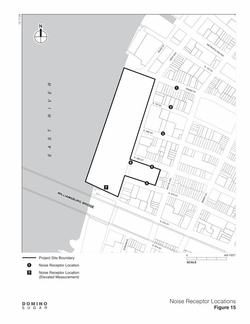
WILLIAMSBURG BRIDGE
KENT A
VE.
S. 3RD ST.
S. 5TH ST.
S. 2ND ST.
WH
YTE
AVE.
S. 4TH ST.
N. 1ST ST.
S. 6TH ST.
S. 1ST ST.
BERR
Y ST
.
RIVER
ST.
METROPOLITAN AVE.
DU
NH
AM P
L.
GRAND ST.
EA
ST
R
IV
ER
12.1
7.09
Noise Receptor LocationsFigure 15
SCALE
0 400 FEET
N
1
2
3
4
5
6
7
D O M I N OS U G A R
Project Site Boundary
Noise Receptor Location
Noise Receptor Location(Elevated Measurement)
1
7

Domino Sugar Rezoning
32
• Traffic and Transportation. This assessment will consider the temporary losses in lanes, walkways, and other transportation services, and increases in vehicles from construction workers and equipment.
• Parking. This assessment will consider the loss of on-street parking due to construction activity.
• Air Quality. Analyze direct emissions from demolition and construction site activity, including fugitive dust and on-site diesel equipment. Analyze potential effects from increases in mobile source emissions of trucks and worker vehicles at nearby sensitive receptors and congested locations, and from potential long-term traffic diversions. Discuss measures and emission reduction strategies to reduce impacts.
• Noise. Analyze noise from the construction activity, including effects on nearby sensitive receptors. Discuss the potential for vibrations caused by construction activities to damage buildings and other resources, and, if necessary, mitigation measures to minimize vibrations.
• Hazardous Materials. In coordination with the hazardous materials task described above, summarize actions to be taken during construction to limit exposure of construction workers, residents, and the environment to potential contaminants.
• Socioeconomic Conditions. This assessment will consider whether construction conditions would affect access to existing businesses, the potential consequences concerning their continued viability, and the potential effects of their loss, if any, on the character of the area.
• Historic Resources. In coordination with the work performed for historic resources above, summarize actions to be taken during project construction to protect any adjacent historic resources from potential construction impacts.
TASK 22: PUBLIC HEALTH
Public health involves the activities that society undertakes to create and maintain conditions in which people can be healthy. Many public health concerns are closely related to air quality, hazardous materials, construction and natural resources. A public health assessment may be warranted if a proposed action results in a) increased vehicular traffic or emissions from stationary sources resulting in significant air quality impacts; b) increased exposure to heavy metals and other contaminants in soil/dust resulting in significant impacts, or the presence of contamination from historic spills or releases of substances that might have affected or might affect ground water to be used as a source of drinking water; c) solid waste management practices that could attract vermin and result in an increase in pest populations; d) potentially significant impacts to sensitive receptors from noise and odors; or e) vapor infiltration from contaminants within a building or underlying soil that may result in significant hazardous materials or air quality impacts. Based on the findings of the tasks discussed above, the EIS will provide an assessment of potential public health impacts, following the guidelines presented in the CEQR Technical Manual.
TASK 23: ALTERNATIVES
The purpose of an alternatives section in an EIS is to examine development options that would tend to reduce action-related impacts. The alternatives are usually defined when the full extent of the proposed action’s impacts is identified, but at this time it is anticipated that they will include the following:

Final Scope of Work
33
• A “No Action” alternative that assumes the continuation of the existing M3-1 zoning on the site and the demolition and redevelopment of portions of the site under that zoning as described above under “Framework for Analysis;”
• A reduced density alternative that would reduce the project’s unmitigated significant adverse impacts;
• The proposed C6-2 zoning on the site of the Refinery would permit a range of commercial uses, including a hotel. Though a hotel is not currently contemplated as part of the proposed project and would likely require additional discretionary actions in the future, the DEIS will include an alternative in which a hotel occupies several floors of the Refinery in order to provide flexibility for possible future program adjustments in response to changing market demands and conditions. Under this alternative, an approximately 112,000 square foot hotel with 150 rooms would be analyzed on floors 4 through 6 of the Refinery and approximately half of the 3rd floor. The hotel would replace approximately 49,000 sf of community facility space and 63,000 sf of residential space in the proposed program analyzed throughout the EIS; and
• An alternative that frames a level of development small enough to eliminate all such significant, unmitigated significant adverse impacts (“No Unmitigated Significant Adverse Impact Alternative”).
In addition, the chapter will analyze an option to include an on-site co-generation facility on the project site.
For technical areas where impacts have been identified, the alternatives analysis will determine whether these impacts would still occur under each alternative.
TASK 24: MITIGATION MEASURES
Where significant proposed action impacts have been identified in Tasks 2 through 22, measures to mitigate those impacts will be described. These measures will be developed and coordinated with the responsible City/State agencies as necessary. Where impacts cannot be mitigated, they will be described as unavoidable adverse impacts.
TASK 25: SUMMARY CHAPTERS
UNAVOIDABLE ADVERSE IMPACTS
Any significant impacts for which no mitigation can be put forth or implemented will be presented as unavoidable adverse impacts.
GROWTH-INDUCING ASPECTS OF THE PROPOSED ACTIONS
Describe any growth-inducing aspects of the proposed project, focusing on whether it is expected to trigger further development.
IRREVERSIBLE AND IRRETRIEVABLE COMMITMENTS OF RESOURCES
This section summarizes the proposed actions and their impacts in terms of the loss of environmental resources, both in the immediate future and the long term.

Domino Sugar Rezoning
34
TASK 26: EXECUTIVE SUMMARY
The executive summary will utilize relevant material from the body of the EIS to describe the proposed actions, their environmental impacts, measures to mitigate those impacts, and alternatives to the proposed actions.

A-1
Attachment A: Transportation Planning Factors
A. INTRODUCTION This attachment provides a detailed discussion of the trip generation assumptions to be used in conducting the traffic and transportation analyses for the Domino Sugar Rezoning project DEIS. The proposed project involves discretionary approvals in connection with the redevelopment of the former Domino Sugar site along the East River waterfront in Williamsburg, Brooklyn. The project site comprises two parcels: Parcel 1, which is located along the East River waterfront between Grand and South 5th Streets (“the waterfront parcel”), and Parcel 2, which is located on the east side of Kent Avenue between South 3rd and South 4th Streets (“the upland parcel”). The project site is currently zoned M3-1 for heavy industrial use.
B. NO ACTION DEVELOPMENT ON THE PROJECT SITE Absent the proposed project, the applicant would develop the project site with uses permitted under the existing M3-1 zoning. The No Action development on the project site includes the retention of the Refinery complex (which would remain vacant due to the high cost of adaptive reuse), development of a storage facility on the waterfront parcel between South 3rd and South 5th Streets, a building materials storage yard along the waterfront between South 2nd and South 1st Streets, and a new distribution facility along the waterfront immediately south of Grand Ferry Park. On the upland portion of the site, a new two-story building with a catering hall/restaurant on the upper floor and parking on the ground floor would be constructed. The total development program for this scenario includes approximately 106,300 square feet (sf) of industrial distribution space, approximately 60,000 sf of storage space, 40,000 sf of catering hall/restaurant space, and 61,000 sf of land used for building material storage (as well as 5,000 sf of office space for this use).
C. PROPOSED DEVELOPMENT The proposed project would facilitate a proposal by the applicant to develop approximately 2.81 million gross square feet (gsf) above-grade, including the reuse of the Refinery complex. Approximately 2.44 million gsf would be dedicated to residential use, up to 127,537 gsf to retail/commercial use, up to 98,738 gsf to commercial office use, and up to 146,451 gsf to community facility use. The applicant currently intends to build 2,200 residential units on the project site, of which 660 would be affordable to low- and moderate-income households. However, it will be assumed for the DEIS analysis purposes that the project could include up to 2,400 residential units (based on an average unit size of approximately 1,000 gsf), 30 percent of which would be affordable to low- and moderate-income households. There would also be approximately 1,698 accessory parking spaces located on the project site in enclosed courtyards and below-grade parking garages.

Domino Sugar Rezoning
A-2
New buildings would be constructed along the remaining four of the waterfront blocks between Grand Street and South 5th Street and a new predominantly residential building would be constructed on the upland block east of Kent Avenue between South 3rd and South 4th Streets. The three existing buildings, which comprise the Refinery complex that are located in the center of the waterfront parcel between South 2nd and South 3rd Streets, would be reused and converted to some combination of residential, retail/commercial, and community facility uses. Ground-floor retail/commercial uses would be located along both sides of Kent Avenue. Publicly accessible open space, including an esplanade along the waterfront that would connect to Grand Ferry Park to the north of the site, would be constructed as part of the proposed project.
D. TRAVEL DEMAND ANALYSIS Travel demand estimates are the foundation of a traffic impact analysis. They project the number of trips (by mode) expected to be generated by the proposed project and are the first step in the transportation assessment. The products of this task are to estimate incremental traffic, transit and pedestrians trips that would be added to the study area’s transportation network—e.g., intersections, pedestrian facilities, transit facilities, parking, etc. In combination with the available capacity of these systems, these factors are the basis for determining transportation impacts.
The travel demand estimates focus on the peak hours when the maximum levels of activity would occur, examining the reasonable worst case scenario with respect to the transportation conditions. These include the weekday morning, midday and evening, and Saturday midday peak hours—thereby conservatively encompassing the periods when future activity in terms of project generated and background traffic would be at its heaviest along the major roadways and local streets in the study area.
The trip generation rates and mode choice factors to be used in estimating the travel demand generated by the proposed project were developed in consultation with the New York City Department of City Planning (DCP). In addition, a variety of sources were consulted in preparing the trip generation estimates including standard references such as the City Environmental Quality Review (CEQR) Technical Manual, Institute of Transportation Engineers (ITE) Trip Generation Manual and Pushkarev and Zupan’s Urban Space for Pedestrians. To further refine the estimates and to focus on the modal splits—the various means of transportation available to patrons accessing the site, including: private autos, taxis, bus, subway, etc.—which vary by location (as they are a function of the transportation services available in a specific area), a number of relevant environmental impact statements (EISs) and environmental assessment statements (EASs) were also consulted. Furthermore, travel demand surveys were conducted at an existing Pathmark Supermarket in Brooklyn to obtain trip rates and modal splits for the proposed project’s supermarket component.
For the purposes of travel demand analysis, it will be assumed that the trips generated by the proposed project would result from the difference in travel demand between the proposed project and the No Action development on the project site. Therefore, vehicular trips generated by the No Action development on the project site will be netted out of the future with the proposed project traffic volumes to obtain the incremental trips resulting from the difference in travel demand between the proposed project and the No Action condition.
The travel demand characteristics for the No Action and proposed developments on the project site are discussed as follows:
Transportation Planning Factors
A-3
NO ACTION DEVELOPMENT ON THE PROJECT SITE
As discussed above, absent the proposed project, the project site could be developed with commercial and industrial uses permitted under the existing M3-1 zoning. The total development program for this scenario includes approximately 106,300 sf of industrial distribution space, approximately 60,000 sf of storage space, 40,000 sf of catering hall/restaurant space, and 61,000 sf of land will be used for building materials storage (including 5,000 sf of office space for this use). The various components of the No Action development on the project site and their corresponding trip generation characteristics are summarized in Table 1 and are discussed in detail as follows:
INDUSTRIAL DISTRIBUTION CENTER/WAREHOUSE
A weekday trip rate of 10.44 trips/1,000 sf based on the information presented in the Greenpoint-Williamsburg Rezoning FEIS will be used to determine the number of daily trips expected to be generated by the distribution center. A Saturday trip rate of 3.61 trips/1,000 sf will be used based on the information presented in the Institute of Transportation Engineers (ITE) Trip Generation Manual, 8th Edition — Land Use Code 150 (Warehousing) to determine the number of trips expected to be generated by the distribution center on a Saturday. Other trip generation factors, including temporal and directional distributions, modal splits, and vehicle occupancies were based on the information presented in the Greenpoint-Williamsburg Rezoning FEIS. In total, the industrial distribution center would generate approximately 102, 78, 71, and 16 vehicle trips (converted to passenger car equivalents [PCEs]) during the AM, midday, and PM, and Saturday midday peak hours, respectively.
CATERING HALL
The catering hall could host a variety of formal events. Trip generation estimates for the catering hall will be developed based on the information presented in the Silvercup West FEIS. To reflect the range of activities that might occur at the catering hall, a medium-size event of approximately 225 guests was assumed for the weekday midday peak hour, and larger-size events of approximately 450 and 670 guests were assumed for the weekday PM and Saturday midday peak hours, respectively. The catering hall is not expected to hold events during the weekday AM peak hour; therefore, no trips will be assumed for that time period. Other trip generation factors, including directional distribution, modal splits, and vehicle occupancies, will be based on the information presented in the Silvercup West FEIS. Since a majority of the guests would arrive and depart in a generally short time frame—just before the start and just after the end of an event—a temporal distribution of 80 percent will be conservatively used for trip generation purposes. In total, the catering hall would generate approximately 120, 240, and 357 trips during the weekday midday and PM and Saturday midday peak hours, respectively.
STORAGE FACILITY
A weekday daily trip rate of 5.26 trips/1,000 sf and a Saturday daily trip rate of 4.91 trips/1,000 sf will be used in estimating the number of trips generated by the storage facility. This trip generation rate is based on the information provided in the ITE Trip Generation Manual, 8th Edition — Land Use Code 151 (Mini-Warehouse). Since no transit and pedestrian trips are expected to be generated by the storage facility due to the nature of such a use—which typically involves transfer (loading/unloading) of material in and out of the facility—a modal split of 25 percent trucks, 70 percent autos, and 5 percent taxis will be used in forecasting the number of trips. The storage

Domino Sugar Rezoning
A-4
facility would generate approximately 16, 28, 34, and 26 vehicle trips (converted to PCEs) during the weekday AM, midday, and PM, and Saturday midday peak hours, respectively.
BUILDING MATERIALS STORAGE USE
For trip generation purposes, a concrete batching facility will be assumed for the building materials storage use. The number of trips expected to be generated by this use will be estimated based on the information presented in the La Farge Cement Company EAS (2004) and ITE Trip Generation Manual, 8th Edition — Land Use Code 150 (Warehousing). To accurately reflect the vehicular activity expected to be generated by such a use, the peak hour trips presented in the La Farge Cement Company EAS will be adjusted based on the size of the building materials storage use under the No Action scenario. In total, the building materials storage yard would generate approximately 8, 8, 0, and 4 vehicle trips (converted to PCEs) during the weekday AM, midday, and PM, and Saturday midday peak hours, respectively.
TOTAL TRIPS
The CEQR Technical Manual recommends converting vehicular trips to PCEs for proposed actions that generate significant volumes of truck trips. Since the No Action development on the project site would primarily consist of industrial uses that would generate a significant number of truck trips, vehicle trips generated during all four peak hours were converted to PCEs for analysis purposes. The only exception would be trips generated by the banquet use, which would generate regular vehicular trips during peak hours. As shown in Table 2, the No Action development on site is estimated to generate approximately 159, 320, 539, and 594 person trips, and 126, 234, 345, and 403 vehicle trips, during the weekday AM, midday, and PM, and Saturday midday peak hours.
PROPOSED DEVELOPMENT
As discussed above, the proposed project would include up to 2,400 residential units, up to 127,537 sf of retail/commercial space, up to 146,451 sf of community facility space, up to 98,738 sf of commercial office space, and approximately 4.03 acres of public open space. For the purposes of trip generation analysis it will be assumed that the retail/commercial space would include approximately 97,537 sf of local retail and the remaining 30,000 sf would function as a supermarket. The proposed project would also provide approximately 1,698 accessory parking spaces.
The projection of future trips associated with the proposed project will account for general travel characteristics related to the project’s anticipated land uses. Travel demand characteristics for each component of the proposed project are summarized in Table 3 and are discussed in detail as follows:
RESIDENTIAL
Trip generation from the 2,400 residential units will be estimated based on a weekday daily trip rate of 8.075 person-trips and a Saturday daily trip rate of 7.679 person-trips per dwelling unit as presented in the CEQR Technical Manual and the Atlantic Yards Arena and Redevelopment Project FEIS (2006), respectively. Other trip generation factors, including temporal and directional distributions, will be based on the information presented in Pushkarev and Zupan’s “Urban Space for Pedestrians.” The modal split estimates and vehicle occupancies will be

Transportation Planning Factors
A-5
based on journey-to-work information obtained from the 2000 US Census Data. Delivery trips will also be estimated based on rates presented in the CEQR Technical Manual. Additionally, the modal split estimates will be adjusted for the Saturday conditions based on the information provided in the Atlantic Yards Arena and Redevelopment Project FEIS (2006). Based on these factors, the residential component of the proposed project would generate approximately 312, 170, 327, and 268 vehicle trips (converted to PCEs) during the weekday AM, midday, and PM, and Saturday midday peak hours, respectively.
LOCAL RETAIL
Trips generated by the local retail component will be estimated based on a daily trip rate of 205 trips/1,000 sf as presented in the CEQR Technical Manual. A linkage factor of 25 percent will be applied to the daily trip rate to account for local trips within the study area. Other trip generation factors, including temporal distribution, modal splits, and vehicle occupancies, will be based on the trip generation factors for local retail use presented in the Retail and Industrial Zoning Text Amendments FGEIS. Delivery trip generation characteristics will be based on the information presented in Wilbur Smith Associates’ “Motor Trucks in the Metropolis.” Based on these factors, the retail component of the proposed project would generate approximately 40, 106, 89, and 92 vehicle trips (converted to PCEs) during the weekday AM, midday, and PM, and Saturday midday peak hours, respectively.
SUPERMARKET USE
Trips generated by the potential supermarket use will be estimated based on the information obtained from surveys conducted during the weekday and Saturday conditions at an existing Pathmark Supermarket located on Albany Avenue in Brooklyn in February 2009. Based on the trip generation factors obtained from these surveys, the supermarket component of the proposed project would generate approximately 117, 136, 200, and 254 vehicle trips (converted to PCEs) during the weekday AM, midday, and PM, and Saturday midday peak hours, respectively.
COMMUNITY FACILITY
The proposed project’s community facility space has not yet been programmed. To conservatively assess the proposed project’s traffic impacts, it will be assumed that approximately 69,000 sf of the 146,451 sf of community facility space would be used as medical offices, approximately 44,135 sf would function as neighborhood offices, and the remaining 33,316 sf would function as a cultural/institutional space (assumed to be a museum for trip generation purposes). Trip generation characteristics for each of the community facility components are discussed as follows:
Medical Offices—Staff: Trips generated by the medical office staff will be estimated based on a weekday daily trip rate of 10 person trips and a Saturday daily trip rate of 4.30 person trips per 1,000 sf, as presented in the 506 East 76th Street Rezoning FEIS and the Jamaica Plan FEIS (2007), respectively. Other trip generation factors, including temporal and directional distributions, and vehicle occupancies, will be based on the information presented in the 506 East 76th Street Rezoning FEIS and the Atlantic Yards Arena and Redevelopment Project FEIS (2006). The modal split estimates will be based on the reverse-journey-to-work information obtained from the 2000 US Census Data. Delivery trip rates for the medical office use will be based on the information presented in the Characteristics of Urban Transportation Demand.

Domino Sugar Rezoning
A-6
Medical Offices—Visitors: Trips generated by the medical office visitors will be estimated based on a weekday daily trip rate of 33.6 person trips and a Saturday daily trip rate of 14.5 person trips per 1,000 sf as presented in the 506 East 76th Street Rezoning FEIS and the Jamaica Plan FEIS (2007), respectively. Other trip generation factors, including temporal and directional distributions, modal splits and vehicle occupancies, will also be based on the information presented in the 506 East 76th Street Rezoning FEIS. The visitor modal split estimates obtained from the 506 East 76th Street Rezoning FEIS will be adjusted to reflect the local transportation characteristics of the study area.
Neighborhood Offices: Trips generated by the neighborhood office use will be estimated based on a weekday daily trip rate of 18 person trips and a Saturday daily trip rate of 0.90 person trips per 1,000 sf, as presented in the CEQR Technical Manual and the Atlantic Yards Arena and Redevelopment Project FEIS (2006), respectively. Temporal distribution rates for the neighborhood office use will be obtained from the CEQR Technical Manual, the Atlantic Yards Arena and Redevelopment Project FEIS (2006), and the Downtown Brooklyn Redevelopment FEIS. The directional distribution rates will be obtained from the Downtown Brooklyn Development FEIS and the Atlantic Yards Arena and Redevelopment Project FEIS (2006). The modal split estimates and vehicle occupancies will be based on the reverse-journey-to-work information obtained from the 2000 US Census Data and the Atlantic Yards Arena and Redevelopment Project FEIS (2006). Delivery trip rates for the neighborhood office use will be based on the information presented in the Characteristics of Urban Transportation Demand.
Museum: Trips generated by the museum component will be estimated based on a weekday daily trip rate of 27.4 person trips and a Saturday daily trip rate of 20.6 person trips per 1,000 sf, as presented in the No. 7 Subway Extension and Hudson Yards Rezoning and Development Program FGEIS (2004). Temporal distribution, directional distribution, vehicle occupancies and delivery trip rates will also be obtained from the No. 7 Subway Extension and Hudson Yards Rezoning and Development Program FGEIS. The modal split estimates for the museum component will be based on the Silvercup West FEIS.
In total, the community facility component of the proposed project would generate a total of 185, 125, 219, and 76 vehicle trips (converted to PCEs) during the weekday AM, midday, and PM, and Saturday midday peak hours, respectively.
COMMERCIAL OFFICE
Trips generated by the commercial office will be estimated based on the same trip generation factors developed for the community facility’s neighborhood office component presented above. In total, the commercial office component of the project would generate a total of 102, 17, 108, and 0 vehicle trips (converted to PCEs) during the weekday AM, midday, and PM, and Saturday midday peak hours, respectively.
WATERFRONT OPEN SPACE
The proposed project would provide approximately 4.03 acres of publicly accessible waterfront open space, which would include an esplanade along the water’s edge, a large open lawn between the esplanade and the Refinery that would highlight this restored historic structure, and new connections that will provide visual and physical access to the waterfront from all streets leading to the project site. Several active recreation areas would be located along the esplanade,

Transportation Planning Factors
A-7
including tot lots, playgrounds, and an active play lawn with a water feature that could function as an ice rink in winter.
Trip generation for the waterfront open space will be estimated separately for the 3.85 acres of publicly accessible waterfront open space and for the potential approximately 9,042-square-foot ice rink. Although, if realized, the ice rink would be operational only during the winter months—the period when the activity for the waterfront open space would be at its lowest—for a conservative analysis, the trip generation activity from these two components was assumed to overlap resulting in higher person and vehicle trips. Trips generated by the waterfront open space will be estimated based on the rates presented in the 363-365 Bond Street FEIS, whereas the trips generated by the ice rink will be estimated based on the information presented in the McCarren Pool Reconstruction EAS.
TOTAL TRIPS
As shown in Tables 4 and 5, the proposed development is estimated to generate approximately 3,062, 3,575, 4,629, and 3,633 person trips, and 762, 572, 957, and 713 vehicle trips (converted to PCEs) during the weekday AM, midday, and PM, and Saturday midday peak hours, respectively.
E. NO BUILD PROJECTS AND GROWTH FACTORS The future conditions without the proposed project will be analyzed for the 2020 analysis year. Future conditions without the proposed project will be established to obtain the level of service projected for future conditions on which trips generated by the proposed project will be added. The impact of the proposed project on local traffic conditions will be assessed based on the changes in local traffic between this future without the proposed project (“No Action”) condition and the future with the proposed project.
Future 2020 No Action traffic volumes will be developed in two ways: 1) applying a background traffic growth rate; and 2) adding traffic to be generated by other future potential development projects that are expected to occur in the future without the proposed project. As per the CEQR Technical Manual, an annual background growth of 1.0 percent is recommended for this section of Brooklyn. Using this growth factor will result in a total of 11 percent background growth by 2020 over the 2009 baseline conditions. Furthermore, development projects located within the ½-mile land-use study area and two additional projects beyond the ½-mile study area forecasted to be completed prior to, or concurrent with, the planned completion of the proposed project, will be incorporated in the No Action volumes. The most notable of the No Action development projects that will be included in the analysis are described below:
• Kedem Winery Redevelopment—450 residential units, approximately 26,400 sf of retail space, a ½-acre public esplanade, and 225 parking spaces;
• Domsey Rezoning at 421-417 Kent Avenue—540 residential units and 120 parking spaces; • Rose Plaza at 470-490 Kent Avenue—801 residential units, approximately 28,130 sf of
retail space, 0.77 acres of public esplanade, and 436 parking spaces; • Wythe Avenue between South 2nd and South 3rd Streets—80 residential units; • 184 Kent Avenue—256 residential units and approximately 27,000 sf of retail space; • Northside Piers—900 residential units; • North 5th Street/Berry Street—40 residential units;

Domino Sugar Rezoning
A-8
• 80 Metropolitan Avenue—123 residential units; • North 1st Street between Kent and Wythe Avenues—41 residential units; • 349 Metropolitan Avenue—35 residential units; • South 4th Street between Driggs Avenue and Roebling Street—46 residential units; • The block bounded by Berry Street, Bedford Avenue, North 3rd Street, and North 4th Street
—195 residential units; • 144 North 8th Street—42 residential units; • North 8th and Roebling Streets—53 residential units; • North 11th Street between Driggs Avenue and Roebling Street—120 residential units; • Brooklyn Navy Yard Redevelopment—approximately 250,000 sf of industrial space for the food
industry, 289,000 sf of media production space, and 600,000 sf of warehouse space; and • Various small residential development projects located in the study area consisting of a total
of 386 residential units.
In addition to the above projects, traffic generated by the projected development sites1
It should be noted that planned development projects within a ¼- up to ½-mile radius are typically included in the No Action conditions. Therefore, the future No Action scenario discussed above is conservative, as it includes future development projects beyond the ½-mile radius in the broader study area, resulting in increased traffic levels by the year 2020.
included in the Greenpoint-Williamsburg Rezoning FEIS will be incorporated in the No Action analysis. In total, trips generated by approximately 7,300 dwelling units and 204,600 sf of retail space identified in the Greenpoint-Williamsburg Rezoning FEIS will be included in the No Action analysis.
F. TRAFFIC STUDY AREA To assess the traffic impacts associated with the proposed project, an overall traffic study area will be defined which would consider the location of the proposed project, primary access routes to-and-from the site, and key intersections that are likely to be affected by the project-generated trips. Since the number of peak hour trips attributed to the proposed project will be substantial, key intersections along major travel corridors and connections to the Brooklyn-Queens Expressway (BQE) will also be selected for detailed analysis.
In total, 48 intersections will be selected for detailed analysis in the primary and secondary study areas for the weekday AM, midday, and PM conditions. For Saturday conditions, a total of 37 intersections will be selected in the primary and secondary study areas. The primary and secondary study area intersections are identified in Figures 1 and 2 for the weekday and Saturday conditions, respectively.
All the intersections in the primary and secondary study areas will be analyzed using the Highway Capacity Software (HCS) — Version 4.1f based on the methodologies presented in the 2000 Highway Capacity Manual (HCM).
1 Including the trips generated by “The Edge” project which is currently under construction on
development site 199 of the Greenpoint-Williamsburg rezoning area.

KENT AVE.
BQE
CNTG
HW
Y
S. 4TH ST.
FLUSHING AVE.
DRIGGS AV
E.
LEE AVE.
N. 8TH ST.
KEAP
ST.
N. 6TH ST.
N. 5TH ST.
N. 7TH ST.
N. 9TH ST.
MEEKER AVE
N. 4TH ST.
PENN ST.
METROPOLITAN AVE.
N. 1ST ST.
N. 3RD ST.
DIVISION AVE.
S. 8TH ST.
LYNCH ST.
HOOPER ST.
HEWES ST.
S. 9TH ST.
ROSS ST.
MAR
CY A
VE.
HEYWARD ST.
RUTLEDGE AVE.
RUTLEDGE ST.
S. 6TH ST.
HARRISON AVE.
MIDDLETON ST.
CLYMER ST.
WILSON ST.
FRAN
KLIN AVE.
SANFO
RD
ST.
SPENC
ER ST.
NO
STRAN
D AVE.
SKILLMAN
ST.
WALW
OR
TH ST.
TAYLOR ST.
S. 10TH ST.
BQE EXIT
NB
HOPE ST.
S. 11TH ST.BROADWAY
RODNEY ST.
MORTON ST.
RUSH ST.
DU
NH
AM P
L.
S. 2ND ST.
HEW
ES S
T.
FROST ST.
RODNEY ST.
KEAP ST.
S. 5TH ST.
RODN
EY S
T.
RE
VIR
TS
AE
KENT AVE.
CLASSO
N
AVE.
BQE
CNTG
HW
Y
S. 4TH ST.
FLUSHING AVE.
DRIGGS AV
E.BERRY ST.
WYT
HE
AVE.
BEDFORD AV
E.
BK Q
N E
XWY
CN
TG H
WY
WIL
LIAM
SBU
RG
ST.
W.
WIL
LIAM
SBU
RG
ST.
E.
LEE AVE.
N. 8TH ST.
KEAP
ST.
N. 6TH ST.
N. 5TH ST.
N. 7TH ST.
N. 9TH ST.
MEEKER AVE
N. 4TH ST.
PENN ST.
METROPOLITAN AVE.
N. 1ST ST.
N. 3RD ST.
DIVISION AVE.
S. 8TH ST.
LYNCH ST.
HOOPER ST.
HEWES ST.
S. 9TH ST.
ROSS ST.
MAR
CY A
VE.
HEYWARD ST.
RUTLEDGE AVE.
RUTLEDGE ST.
S. 6TH ST.
HARRISON AVE.
MIDDLETON ST.
CLYMER ST.
WILSON ST.
FRAN
KLIN AVE.
SANFO
RD
ST.
SPENC
ER ST.
NO
STRAN
D AVE.
SKILLMAN
ST.
WALW
OR
TH ST.
TAYLOR ST.
S. 10TH ST.
BQE
EXIT
NB
HOPE ST.
S. 11TH ST.BROADWAY
RODNEY ST.
MORTON ST.
RUSH ST.
DU
NH
AM P
L.
S. 2ND ST.
HEW
ES S
T.
RODNEY ST.
KEAP ST.
S. 5TH ST.
RODN
EY S
T.
RE
VIR
TS
AE
S. 3RD ST.
S. 2ND ST.
S. 1ST ST.
GRAND ST.
S. 3RD ST.
S. 2ND ST.
HAVE
MEY
ER S
T.
HAVE
MEY
ER S
T.ROEB
LING
ST.
ROEB
LING
ST.
S. 1ST ST.
GRAND ST.
WILLIAMSBURG BRIDGE TO MANHATTAN
BQE
Traffic Analysis Locations-WeekdayFigure 1DOMINO SUGAR REZONING
12.8
.09
Project Site Boundary
ATR Location Count
Primary Study Area (Signalized Intersection)
Primary Study Area (Unsignalized Intersection)
Secondary Study Area (Signalized Intersection)
Secondary Study Area (Unsignalized Intersection)
SCALE
0 1000 FEET

KENT AVE.
BQE
CNTG
HW
Y
S. 4TH ST.
FLUSHING AVE.
DRIGGS AV
E.
LEE AVE.
N. 8TH ST.
KEAP
ST.
N. 6TH ST.
N. 5TH ST.
N. 7TH ST.
N. 9TH ST.
MEEKER AVE
N. 4TH ST.
PENN ST.
METROPOLITAN AVE.
N. 1ST ST.
N. 3RD ST.
DIVISION AVE.
S. 8TH ST.
LYNCH ST.
HOOPER ST.
HEWES ST.
S. 9TH ST.
ROSS ST.
MAR
CY A
VE.
HEYWARD ST.
RUTLEDGE AVE.
RUTLEDGE ST.
S. 6TH ST.
HARRISON AVE.
MIDDLETON ST.
CLYMER ST.
WILSON ST.
FRAN
KLIN AVE.
SANFO
RD
ST.
SPENC
ER ST.
NO
STRAN
D AVE.
SKILLMAN
ST.
WALW
OR
TH ST.
TAYLOR ST.
S. 10TH ST.
BQE EXIT
NB
HOPE ST.
S. 11TH ST.BROADWAY
RODNEY ST.
MORTON ST.
RUSH ST.
DU
NH
AM P
L.
S. 2ND ST.
HEW
ES S
T.
FROST ST.
RODNEY ST.
KEAP ST.
S. 5TH ST.
RODN
EY S
T.
RE
VIR
TS
AE
KENT AVE.
CLASSO
N
AVE.
BQE
CNTG
HW
Y
S. 4TH ST.
FLUSHING AVE.
DRIGGS AV
E.BERRY ST.
WYT
HE
AVE.
BEDFORD AV
E.
BK Q
N E
XWY
CN
TG H
WY
WIL
LIAM
SBU
RG
ST.
W.
WIL
LIAM
SBU
RG
ST.
E.
LEE AVE.
N. 8TH ST.
KEAP
ST.
N. 6TH ST.
N. 5TH ST.
N. 7TH ST.
N. 9TH ST.
MEEKER AVE
N. 4TH ST.
PENN ST.
METROPOLITAN AVE.
N. 1ST ST.
N. 3RD ST.
DIVISION AVE.
S. 8TH ST.
LYNCH ST.
HOOPER ST.
HEWES ST.
S. 9TH ST.
ROSS ST.
MAR
CY A
VE.
HEYWARD ST.
RUTLEDGE AVE.
RUTLEDGE ST.
S. 6TH ST.
HARRISON AVE.
MIDDLETON ST.
CLYMER ST.
WILSON ST.
FRAN
KLIN AVE.
SANFO
RD
ST.
SPENC
ER ST.
NO
STRAN
D AVE.
SKILLMAN
ST.
WALW
OR
TH ST.
TAYLOR ST.
S. 10TH ST.
BQE
EXIT
NB
HOPE ST.
S. 11TH ST.BROADWAY
RODNEY ST.
MORTON ST.
RUSH ST.
DU
NH
AM P
L.
S. 2ND ST.
HEW
ES S
T.
RODNEY ST.
KEAP ST.
S. 5TH ST.
RODN
EY S
T.
RE
VIR
TS
AE
S. 3RD ST.
S. 2ND ST.
S. 1ST ST.
GRAND ST.
S. 3RD ST.
S. 2ND ST.
HAVE
MEY
ER S
T.
HAVE
MEY
ER S
T.
ROEB
LING
ST.
ROEB
LING
ST.
S. 1ST ST.
GRAND ST.
WILLIAMSBURG BRIDGE TO MANHATTAN
BQE
Traffic Analysis Locations-SaturdayFigure 2DOMINO SUGAR REZONING
12.8
.09
Project Site Boundary
ATR Location Count
Primary Study Area (Signalized Intersection)
Primary Study Area (Unsignalized Intersection)
Secondary Study Area (Signalized Intersection)
Secondary Study Area (Unsignalized Intersection)
SCALE
0 1000 FEET

Transportation Planning Factors
A-9
G. BIBLIOGRAPHY In the preparation of travel demand estimates discussed in this memorandum, the following sources of technical information were consulted:
1. City Environmental Quality Review (CEQR) Technical Manual, 2001;
2. Institute of Transportation Engineers (ITE) Trip Generation Manual, 8th Edition;
3. Urban Space for Pedestrians by Pushkarev and Zupan;
4. Greenpoint-Williamsburg Rezoning FEIS (CEQR # 04DCP003K);
5. Silvercup West FEIS (CEQR # 05DCP080Q);
6. Farley Post Office/Moynihan Station Redevelopment Project FEIS;
7. Atlantic Yards Arena and Redevelopment Project FEIS;
8. Wilbur Smith and Associates, Motor Trucks in the Metrpolis;
9. 2000 United States Census Data;
10. Flushing/Bedford Rezoning FEIS (CEQR # 00DCP015K);
11. 506 East 76th Street Rezoning FEIS (CEQR # 98DCP009M);
12. Jamaica Plan FEIS;
13. Characteristics of Urban Transportation Demand;
14. Downtown Brooklyn Rezoning FEIS (CEQR # 03DME016K);
15. Retail and Industrial Zoning Text Amendment FGEIS;
16. McCarren Pool Park Reconstruction EAS;
17. Toll Brothers – Gowanus Rezoning FEIS;
18. No. 7 Subway Extension and Hudson Yards Rezoning and Development Program FGEIS;
19. La Farge Cement Company EAS (2004); and
20. Supermarket surveys at Albany Avenue Pathmark in Brooklyn.