Embed Size (px)
Citation preview
San Giovanni
Living Next to a Transit Corridor
Brooke ShinMadeleine GalvinRaphael LaudeShareef Hussam
Introduction00
San Giovanni in the urban context of Rome
Rome Workshop
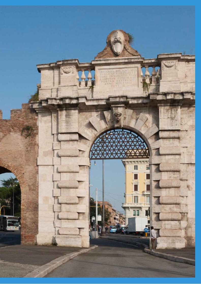
Image Subject
Rome Workshop
Outline
3
Introduction 1
OutlineGetting OrientedA Transit CorridorGuiding QuestionMethodology
History 15
SummaryTimelineA Plan for San GiovanniConstruction BeginsA Polycentric PlanMetro Construction
Statistics 19
SummaryKey Data PointsDemographics & HousingLivability Audit
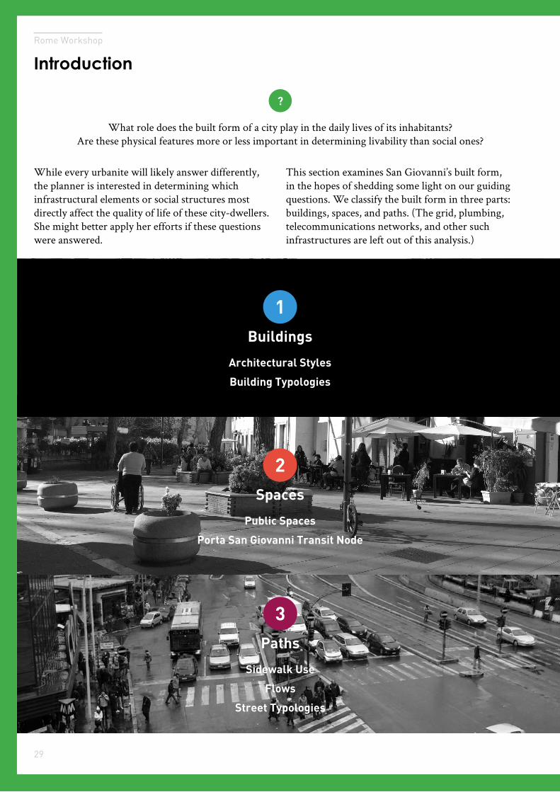
Built Form 27
SummarySolidsVoidsMobility
Services 43
SummaryGround-Floor UsePrimary Area ServicesSecondary Area ServicesInstitutions
Engagement 49
SummaryKey StakeholdersIntercept InterviewsCognitive Mapping
Conclusion 55
Key TakeawaysNext StepsBibliography, Appendix
00
01
02
03
04
05
06
Contents
4
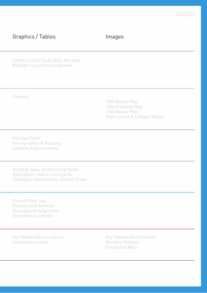
Graphics / Tables
Introduction
Images
Urban Context, Study Area, Key SitesBroader / Local Transit Network
Timeline
Key Data TableDemographics & HousingLivability Audit Locations
Building Types, Architectural StylesOpen Space, Interior CourtyardsSidewalks, Intersections, Streets, Flows
Ground-Floor UsePrimary Area ServicesSecondary Area ServicesInstitutions Locations
Key Stakeholders LocationsInterview Locations
1909 Master Plan1936 Historical Map1962 Master PlanMetro Line A & C Maps / Photos
Key Stakeholders PortraitsResident PortraitsConceptual Maps
Rome Workshop
Introduction
5
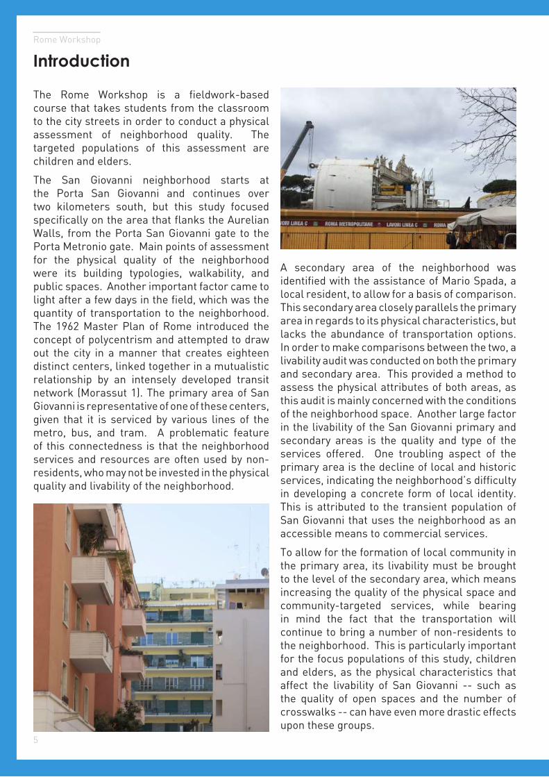
The Rome Workshop is a fieldwork-based course that takes students from the classroom to the city streets in order to conduct a physical assessment of neighborhood quality. The targeted populations of this assessment are children and elders.
The San Giovanni neighborhood starts at the Porta San Giovanni and continues over two kilometers south, but this study focused specifically on the area that flanks the Aurelian Walls, from the Porta San Giovanni gate to the Porta Metronio gate. Main points of assessment for the physical quality of the neighborhood were its building typologies, walkability, and public spaces. Another important factor came to light after a few days in the field, which was the quantity of transportation to the neighborhood. The 1962 Master Plan of Rome introduced the concept of polycentrism and attempted to draw out the city in a manner that creates eighteen distinct centers, linked together in a mutualistic relationship by an intensely developed transit network (Morassut 1). The primary area of San Giovanni is representative of one of these centers, given that it is serviced by various lines of the metro, bus, and tram. A problematic feature of this connectedness is that the neighborhood services and resources are often used by non-residents, who may not be invested in the physical quality and livability of the neighborhood.
A secondary area of the neighborhood was identified with the assistance of Mario Spada, a local resident, to allow for a basis of comparison. This secondary area closely parallels the primary area in regards to its physical characteristics, but lacks the abundance of transportation options. In order to make comparisons between the two, a livability audit was conducted on both the primary and secondary area. This provided a method to assess the physical attributes of both areas, as this audit is mainly concerned with the conditions of the neighborhood space. Another large factor in the livability of the San Giovanni primary and secondary areas is the quality and type of the services offered. One troubling aspect of the primary area is the decline of local and historic services, indicating the neighborhood’s difficulty in developing a concrete form of local identity. This is attributed to the transient population of San Giovanni that uses the neighborhood as an accessible means to commercial services.
To allow for the formation of local community in the primary area, its livability must be brought to the level of the secondary area, which means increasing the quality of the physical space and community-targeted services, while bearing in mind the fact that the transportation will continue to bring a number of non-residents to the neighborhood. This is particularly important for the focus populations of this study, children and elders, as the physical characteristics that affect the livability of San Giovanni -- such as the quality of open spaces and the number of crosswalks -- can have even more drastic effects upon these groups.
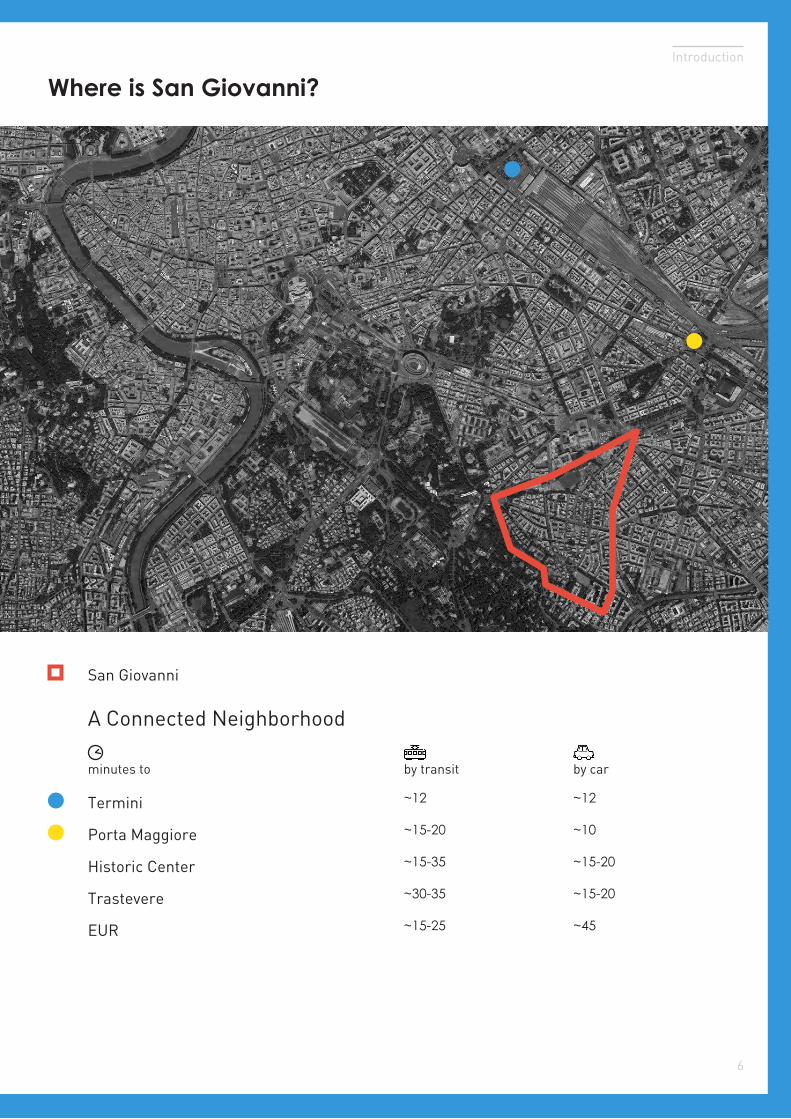
Where is San Giovanni?
6
Introduction
Termini ~12
Historic Center
Trastevere
Porta Maggiore
EUR
minutes to by transit by car
San Giovanni
A Connected Neighborhood
~12
~15-20 ~10
~15-35 ~15-20
~15-25 ~45
~30-35 ~15-20
Rome Workshop
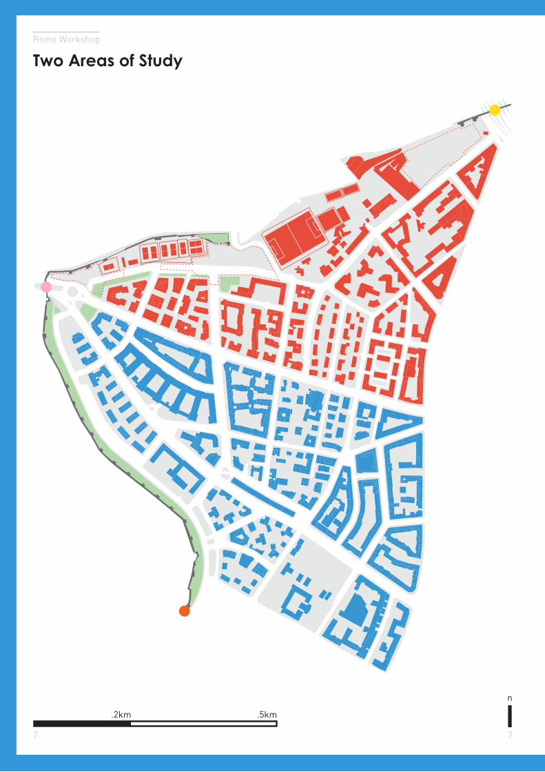
Two Areas of Study
7 7
.5km.2km
n
Introduction
8
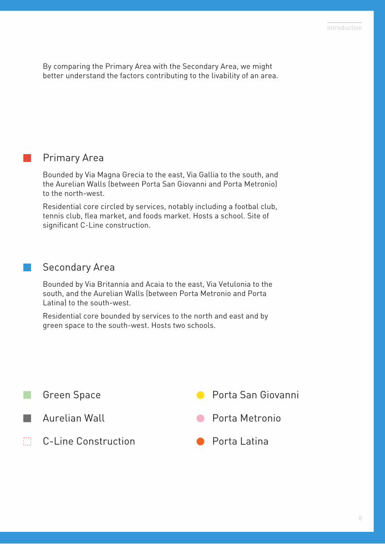
Primary Area
Secondary Area
Bounded by Via Magna Grecia to the east, Via Gallia to the south, and the Aurelian Walls (between Porta San Giovanni and Porta Metronio) to the north-west.
Residential core circled by services, notably including a footbal club, tennis club, flea market, and foods market. Hosts a school. Site of significant C-Line construction.
Green Space
Aurelian Wall
C-Line Construction
Bounded by Via Britannia and Acaia to the east, Via Vetulonia to the south, and the Aurelian Walls (between Porta Metronio and Porta Latina) to the south-west.
Residential core bounded by services to the north and east and by green space to the south-west. Hosts two schools.
By comparing the Primary Area with the Secondary Area, we might better understand the factors contributing to the livability of an area.
Porta San Giovanni
Porta Metronio
Porta Latina
Rome Workshop
9
Key Sites: Primary Area
n
.5km.2km
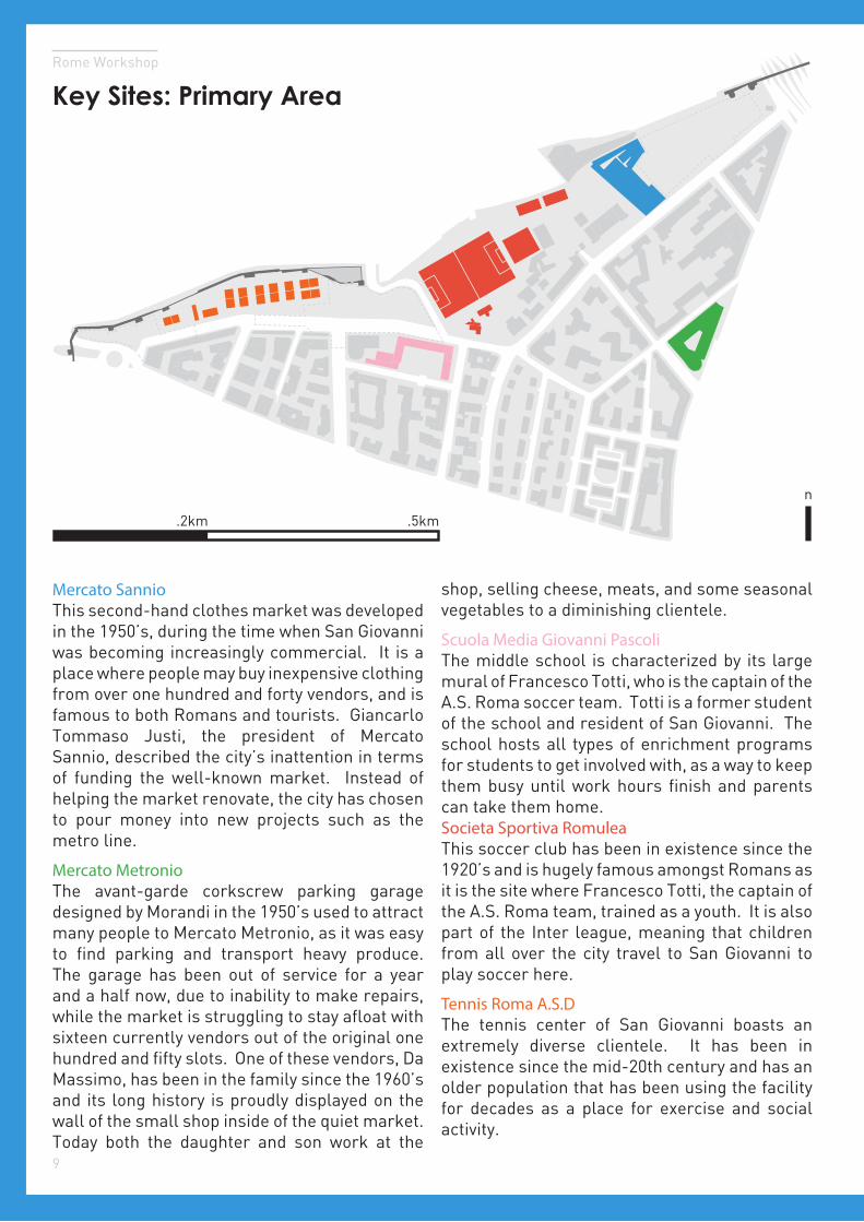
Mercato SannioThis second-hand clothes market was developed in the 1950’s, during the time when San Giovanni was becoming increasingly commercial. It is a place where people may buy inexpensive clothing from over one hundred and forty vendors, and is famous to both Romans and tourists. Giancarlo Tommaso Justi, the president of Mercato Sannio, described the city’s inattention in terms of funding the well-known market. Instead of helping the market renovate, the city has chosen to pour money into new projects such as the metro line.
Mercato MetronioThe avant-garde corkscrew parking garage designed by Morandi in the 1950’s used to attract many people to Mercato Metronio, as it was easy to find parking and transport heavy produce. The garage has been out of service for a year and a half now, due to inability to make repairs, while the market is struggling to stay afloat with sixteen currently vendors out of the original one hundred and fifty slots. One of these vendors, Da Massimo, has been in the family since the 1960’s and its long history is proudly displayed on the wall of the small shop inside of the quiet market. Today both the daughter and son work at the
shop, selling cheese, meats, and some seasonal vegetables to a diminishing clientele.
Scuola Media Giovanni PascoliThe middle school is characterized by its large mural of Francesco Totti, who is the captain of the A.S. Roma soccer team. Totti is a former student of the school and resident of San Giovanni. The school hosts all types of enrichment programs for students to get involved with, as a way to keep them busy until work hours finish and parents can take them home.Societa Sportiva RomuleaThis soccer club has been in existence since the 1920’s and is hugely famous amongst Romans as it is the site where Francesco Totti, the captain of the A.S. Roma team, trained as a youth. It is also part of the Inter league, meaning that children from all over the city travel to San Giovanni to play soccer here.
Tennis Roma A.S.DThe tennis center of San Giovanni boasts an extremely diverse clientele. It has been in existence since the mid-20th century and has an older population that has been using the facility for decades as a place for exercise and social activity.
Introduction
10
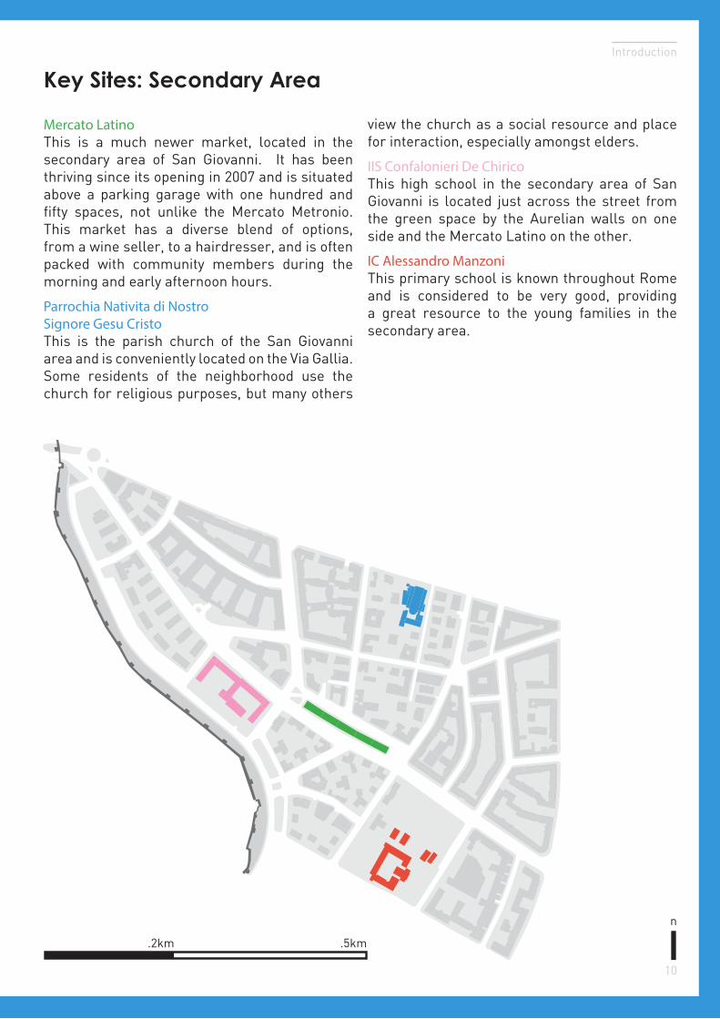
Mercato LatinoThis is a much newer market, located in the secondary area of San Giovanni. It has been thriving since its opening in 2007 and is situated above a parking garage with one hundred and fifty spaces, not unlike the Mercato Metronio. This market has a diverse blend of options, from a wine seller, to a hairdresser, and is often packed with community members during the morning and early afternoon hours.
Parrochia Nativita di Nostro Signore Gesu CristoThis is the parish church of the San Giovanni area and is conveniently located on the Via Gallia. Some residents of the neighborhood use the church for religious purposes, but many others
view the church as a social resource and place for interaction, especially amongst elders.
IIS Confalonieri De ChiricoThis high school in the secondary area of San Giovanni is located just across the street from the green space by the Aurelian walls on one side and the Mercato Latino on the other.
IC Alessandro ManzoniThis primary school is known throughout Rome and is considered to be very good, providing a great resource to the young families in the secondary area.
Key Sites: Secondary Area
.5km.2km
n
Rome Workshop
Aurelian Wall
11
Broader Transit Network
San Giovanni
Tiber
Rail NetworkGreen Space
Important Auto Corridors
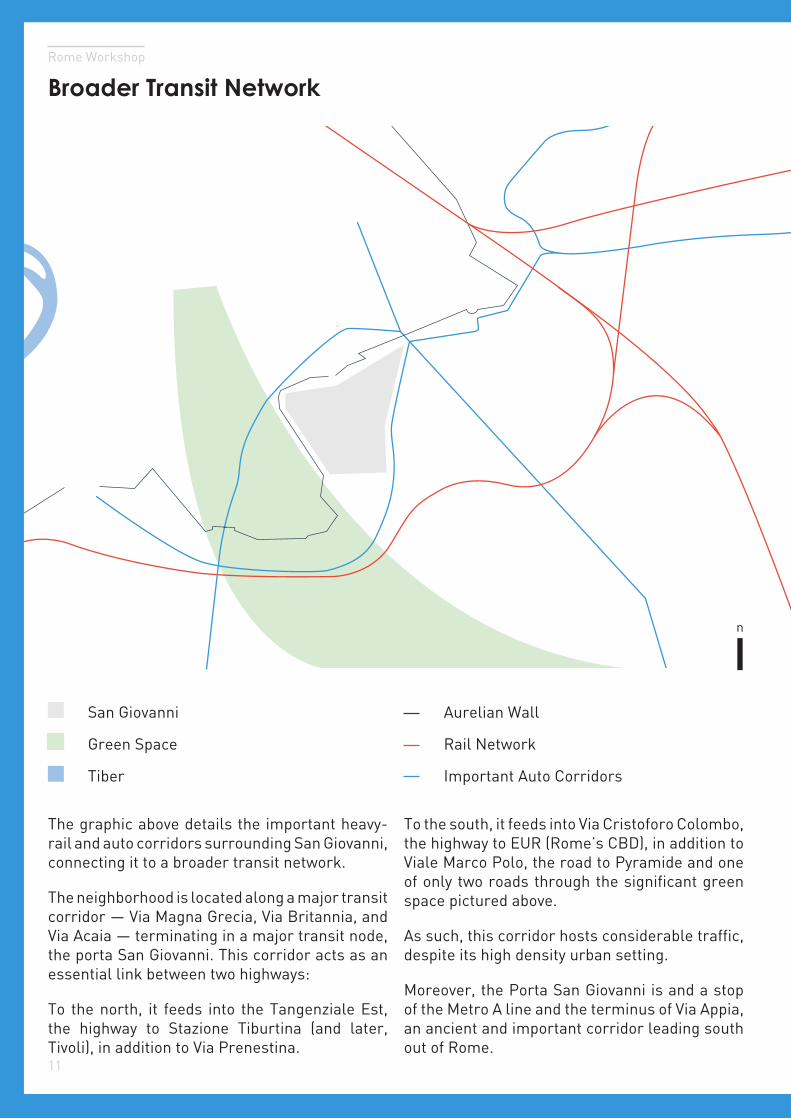
The graphic above details the important heavy-rail and auto corridors surrounding San Giovanni, connecting it to a broader transit network.
The neighborhood is located along a major transit corridor — Via Magna Grecia, Via Britannia, and Via Acaia — terminating in a major transit node, the porta San Giovanni. This corridor acts as an essential link between two highways:
To the north, it feeds into the Tangenziale Est, the highway to Stazione Tiburtina (and later, Tivoli), in addition to Via Prenestina.
To the south, it feeds into Via Cristoforo Colombo, the highway to EUR (Rome’s CBD), in addition to Viale Marco Polo, the road to Pyramide and one of only two roads through the significant green space pictured above.
As such, this corridor hosts considerable traffic, despite its high density urban setting.
Moreover, the Porta San Giovanni is and a stop of the Metro A line and the terminus of Via Appia, an ancient and important corridor leading south out of Rome.
n
Introduction
12
Local Public Transportation Network
Metro Line A
3 Tram
Planned Metro Line C
FR 1, 3, & 5
Bus Routes
Metro Stop
Planned Stop
Bus Terminal
The graphic above (not to scale) details the important public transportation network surrounding San Giovanni.
Many of these transit nodes are focused through
the Porta San Giovanni, creating a transportation node from which much of Rome can be reached.
Two planned stops for the extended Metro Line C are in construction, detailed in dashed yellow.
San Giovanni Porta San Giovanni Transit Node
Tram Stop
Regional Train Stop
Rome Workshop
13
Guiding Question
?How does neighborhood proximity to a major transit corridor affect
livability, especially for children and elders?
- Creates pollution, congestion
- Accelerates deterioration of infrastructure
- Changes types of local services
- Increases proportion of transient residents
Hypotheses
Introduction
14
Methodology
The main methodologies employed in our assessment of San Giovanni can be divided into five overarching components: historical analysis, statistical research, service audit, survey of built form, and neighborhood engagement. Together, the histories, data, graphics, and narratives these methodologies yield provide us with a fuller understanding of San Giovanni’s origins, transformations, and prospects.
1Historical Analysis
Analyzing San Giovanni’s origins, planning, and development provides us with a fuller understanding of the neighborhood today. Most research was conducted online, focusing on Rome’s Master Plans from 1909 to the present. By assessing the changes brought by each plan, an outline of the area’s urban history was configured. Additional context came from the physical design of many of the buildings, with their architectural styles serving as a proxy for building period. Finally, additional pieces of information about the development of San Giovanni and its various services came from key interviews with neighborhood figures and residents. Opening dates for the majority of commercial sites along Via Magna Grecia and Via Gallia were obtained by speaking with shop owners and workers, providing insight into the changing character of these key paths.
2Statistical Research
To conduct a statistical analysis of San Giovanni, Census data from the 2001 and 2011 surveys were gathered from the Italian National Institute of Statistics (ISTAT) website. These data were then formatted and organized into a Microsoft Excel spreadsheet, separated for three different areas: the primary study area, secondary study area, and for Rome.
3Built Form Survey
Section four attempts a survey of San Giovanni’s built form in order to understand the neighborhood’s physical infrastructure and how it affects livability for residents. Architectural styles, building typologies, street typologies, and public spaces were identified, categorized, and mapped. A survey of San Giovanni’s sidewalks and intersections provided the basis for the assessment of neighborhood walkability. Adobe Illustrator was the main tool used in the creation of these graphics.
4Service Audit
Preliminary research on the services in the San Giovanni neighborhood was based on the information provided by Google Earth and the Roma Capitale website. On-site research and interviews with residents and shopkeepers were conducted during fieldwork to revise and substantiate the service inventories. Types of services were determined based on the interviews and on-site research. Community targeted services consist of restaurants, bars, grocery stores, schools, churches, banks, medical services, nursing homes and a culture center. Transient services include bed and breakfasts, beauty salons and clothing stores, tattoo parlors, travel agencies, and automobile repair shops.
5Engagement
To better understand how San Giovanni’s services and built form affect the lives of its residents, stakeholder meetings were held and intercept interviews conducted. This methodology is elaborated in section five.
01
Rome Workshop
History
Conceived in the 1909 Master Plan as a residential neighborhood, San Giovanni has since transformed into a hub of transportation and commerce.
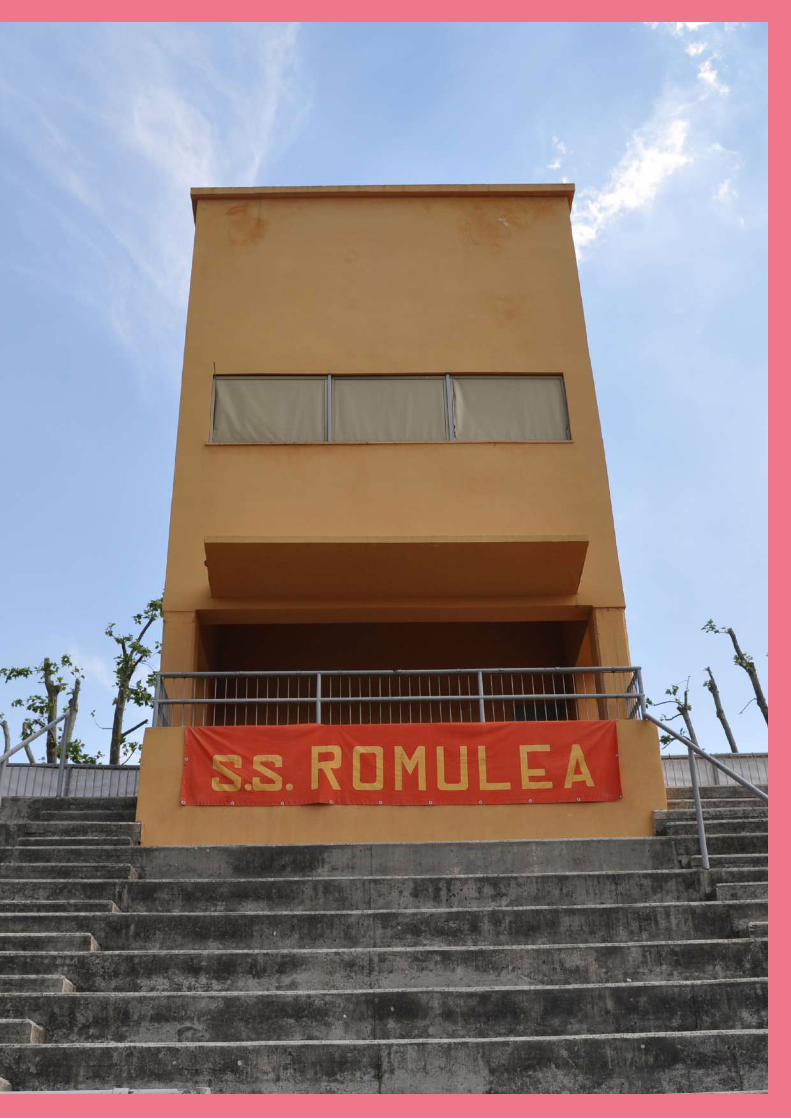
Image Subject
Image Subject
Piazza Tusculo from Via Gallia
Roma Sparita
19
Rome Workshop
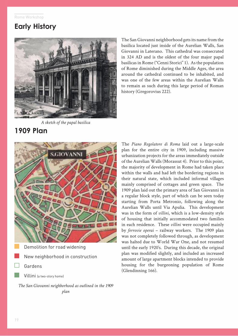
The San Giovanni neighborhood gets its name from the basilica located just inside of the Aurelian Walls, San Giovanni in Laterano. This cathedral was consecrated in 324 AD and is the oldest of the four major papal basilicas in Rome (“Cenni Storici” 1). As the population of Rome diminished during the Middle Ages, the area around the cathedral continued to be inhabited, and was one of the few areas within the Aurelian Walls to remain as such during this large period of Roman history (Gregorovius 222).
1909 Plan
Early History
The Piano Regolatore di Roma laid out a large-scale plan for the entire city in 1909, including massive urbanization projects for the areas immediately outside of the Aurelian Walls (Morassut 4). Prior to this point, the majority of development in Rome had taken place within the walls and had left the bordering regions in their natural state, which included informal villages mainly comprised of cottages and green space. The 1909 plan laid out the primary area of San Giovanni in a regular block style, part of which can be seen today starting from Porta Metronio, following along the Aurelian Walls until Via Apulia. This development was in the form of villini, which is a low-density style of housing that initially accommodated two families in each residence. These villini were occupied mainly by ferrovie operai – railway workers. The 1909 plan was not completely followed through, as development was halted due to World War One, and not resumed until the early 1920’s. During this decade, the original plan was modified slightly, and included an increased amount of large apartment blocks intended to provide housing for the burgeoning population of Rome (Glendinning 166).
Demolition for road widening
New neighborhood in construction
Gardens
Villini (a two-story home)
A sketch of the papal basilica
The San Giovanni neighborhood as outlined in the 1909
plan
20
History
In 1926 there was an expansion of the Porta San Giovanni, which added two entrances on either side of the original door, creating a wide portal linking the inner city to the neighborhood. There was another plan of the city in 1931 that laid out the San Giovanni neighborhood as it is seen today. This corresponded with the Fascist-style housing that began to appear in the city-center, and eventually reached San Giovanni, primarily along the side streets in the western part of the neighborhood. Gradual expansion of the city population led to the construction of additional housing during the 1950’s and 60’s, which completely tapered off by the 70’s (“Basi territoriali e variabili censuarie”).
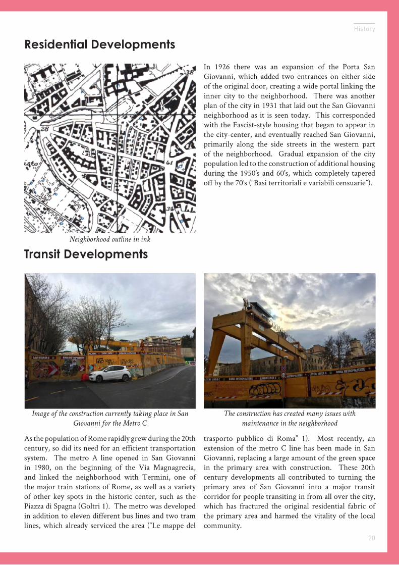
Transit Developments
Residential Developments
As the population of Rome rapidly grew during the 20th century, so did its need for an efficient transportation system. The metro A line opened in San Giovanni in 1980, on the beginning of the Via Magnagrecia, and linked the neighborhood with Termini, one of the major train stations of Rome, as well as a variety of other key spots in the historic center, such as the Piazza di Spagna (Goltri 1). The metro was developed in addition to eleven different bus lines and two tram lines, which already serviced the area (“Le mappe del
trasporto pubblico di Roma” 1). Most recently, an extension of the metro C line has been made in San Giovanni, replacing a large amount of the green space in the primary area with construction. These 20th century developments all contributed to turning the primary area of San Giovanni into a major transit corridor for people transiting in from all over the city, which has fractured the original residential fabric of the primary area and harmed the vitality of the local community.
Neighborhood outline in ink
The construction has created many issues with
maintenance in the neighborhood
Image of the construction currently taking place in San
Giovanni for the Metro C

02
Demographics and FamiliesEducation and EmploymentHousing and Development
Rome Workshop
Statistics
Image Subject
Image Credit
23
Rome Workshop
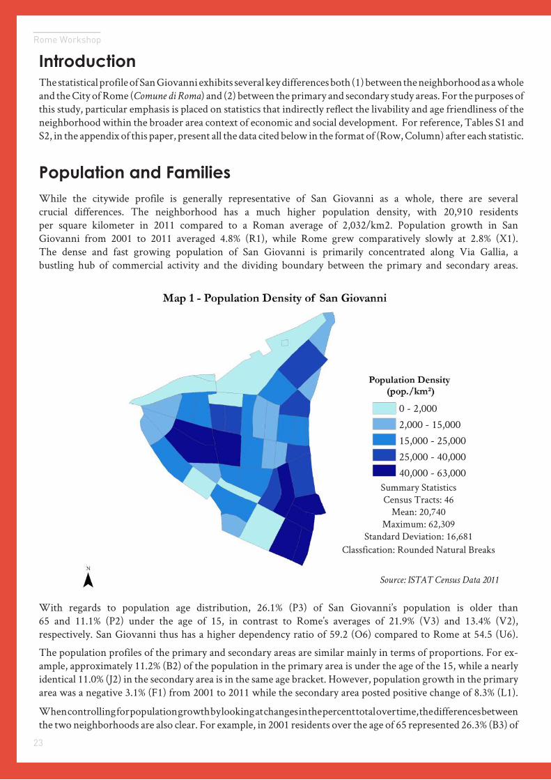
Population and FamiliesWhile the citywide profile is generally representative of San Giovanni as a whole, there are several crucial differences. The neighborhood has a much higher population density, with 20,910 residents per square kilometer in 2011 compared to a Roman average of 2,032/km2. Population growth in San Giovanni from 2001 to 2011 averaged 4.8% (R1), while Rome grew comparatively slowly at 2.8% (X1). The dense and fast growing population of San Giovanni is primarily concentrated along Via Gallia, a bustling hub of commercial activity and the dividing boundary between the primary and secondary areas.
With regards to population age distribution, 26.1% (P3) of San Giovanni’s population is older than 65 and 11.1% (P2) under the age of 15, in contrast to Rome’s averages of 21.9% (V3) and 13.4% (V2), respectively. San Giovanni thus has a higher dependency ratio of 59.2 (O6) compared to Rome at 54.5 (U6).
The population profiles of the primary and secondary areas are similar mainly in terms of proportions. For ex-ample, approximately 11.2% (B2) of the population in the primary area is under the age of the 15, while a nearly identical 11.0% (J2) in the secondary area is in the same age bracket. However, population growth in the primary area was a negative 3.1% (F1) from 2001 to 2011 while the secondary area posted positive change of 8.3% (L1).
When controlling for population growth by looking at changes in the percent total over time, the differences between the two neighborhoods are also clear. For example, in 2001 residents over the age of 65 represented 26.3% (B3) of
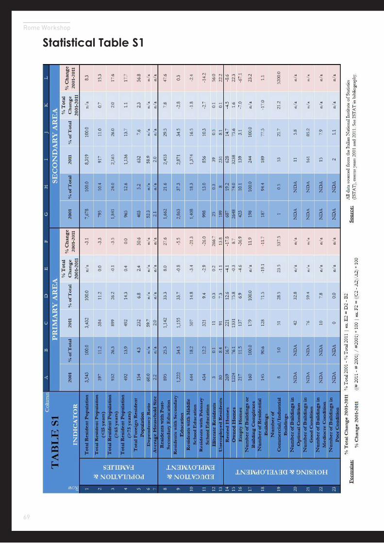
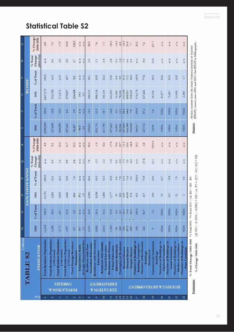
The statistical profile of San Giovanni exhibits several key differences both (1) between the neighborhood as a whole and the City of Rome (Comune di Roma) and (2) between the primary and secondary study areas. For the purposes of this study, particular emphasis is placed on statistics that indirectly reflect the livability and age friendliness of the neighborhood within the broader area context of economic and social development. For reference, Tables S1 and S2, in the appendix of this paper, present all the data cited below in the format of (Row, Column) after each statistic.
Introduction
Population Density of San Giovanni
Source: ISTAT Census Data 2011
Summary StatisticsCensus Tracts: 46
Mean: 20,740Maximum: 62,309
Standard Deviation: 16,681Classfication: Rounded Natural Breaks
0 - 2,0002,000 - 15,00015,000 - 25,00025,000 - 40,00040,000 - 63,000
Source: ISTAT Census Data 2011
24
Statistics
the primary area and 24.0% (H3) of the secondary area populations. By 2011, these percentages had changed to 26.2% (D3) and 26.0% (J3) respectively, reflecting changes of -0.1% (E3) and 2.0% (K3). These trends appear to indicate ei-ther a) a growing preference for the secondary area over the primary area or b) an equilibrating effect whereby the two areas are reaching parity in terms of statistical profiles. Both scenarios indicate Romans’ strong desire to live second-ary area relative to the primary and in this case, population growth can be inferred as a proxy for relative liveability.
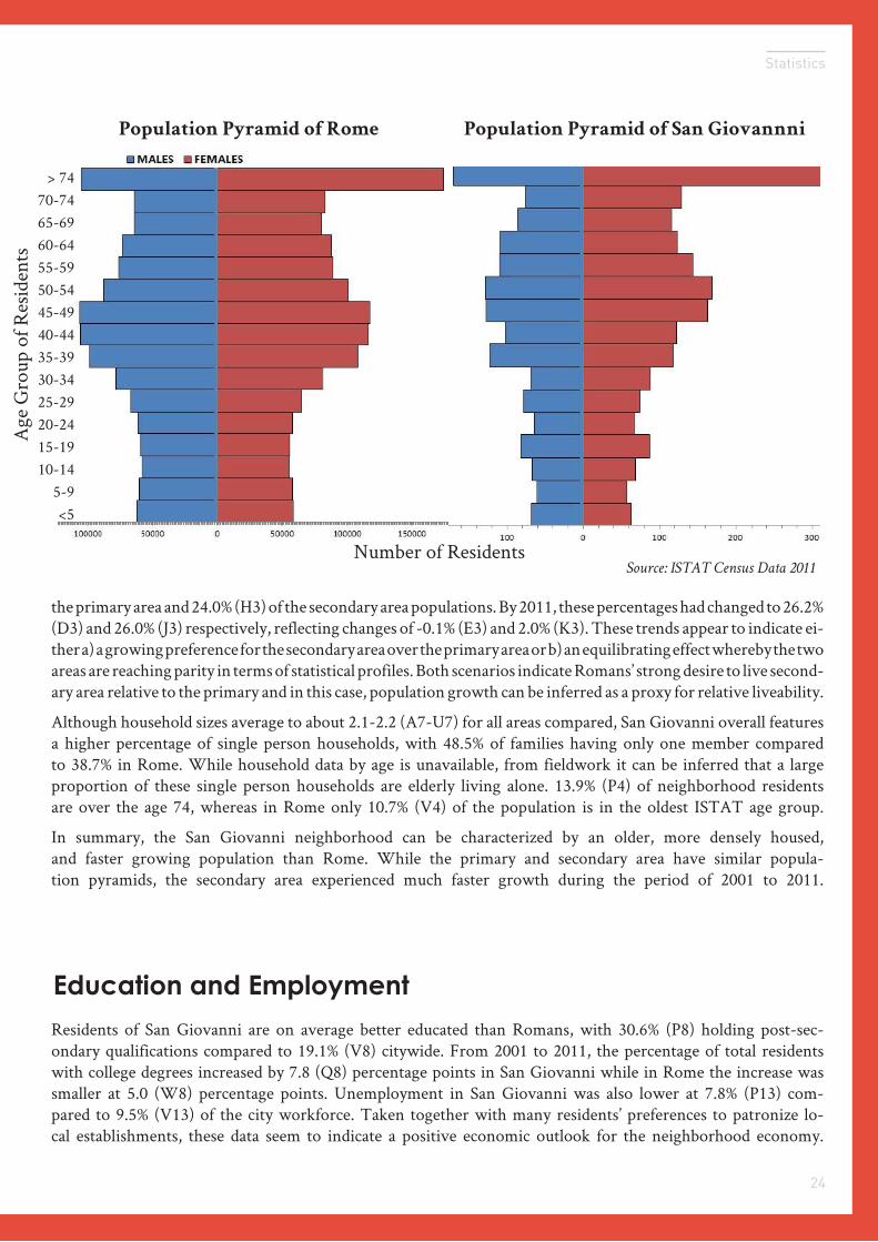
Although household sizes average to about 2.1-2.2 (A7-U7) for all areas compared, San Giovanni overall features a higher percentage of single person households, with 48.5% of families having only one member compared to 38.7% in Rome. While household data by age is unavailable, from fieldwork it can be inferred that a large proportion of these single person households are elderly living alone. 13.9% (P4) of neighborhood residents are over the age 74, whereas in Rome only 10.7% (V4) of the population is in the oldest ISTAT age group.
In summary, the San Giovanni neighborhood can be characterized by an older, more densely housed, and faster growing population than Rome. While the primary and secondary area have similar popula-tion pyramids, the secondary area experienced much faster growth during the period of 2001 to 2011.
Population Pyramid of Rome Population Pyramid of San Giovannni
> 7470-7465-6960-6455-5950-5445-4940-4435-3930-3425-2920-2415-1910-14
5-9<5
Number of Residents
Age
Gro
up o
f Res
iden
ts
Education and Employment
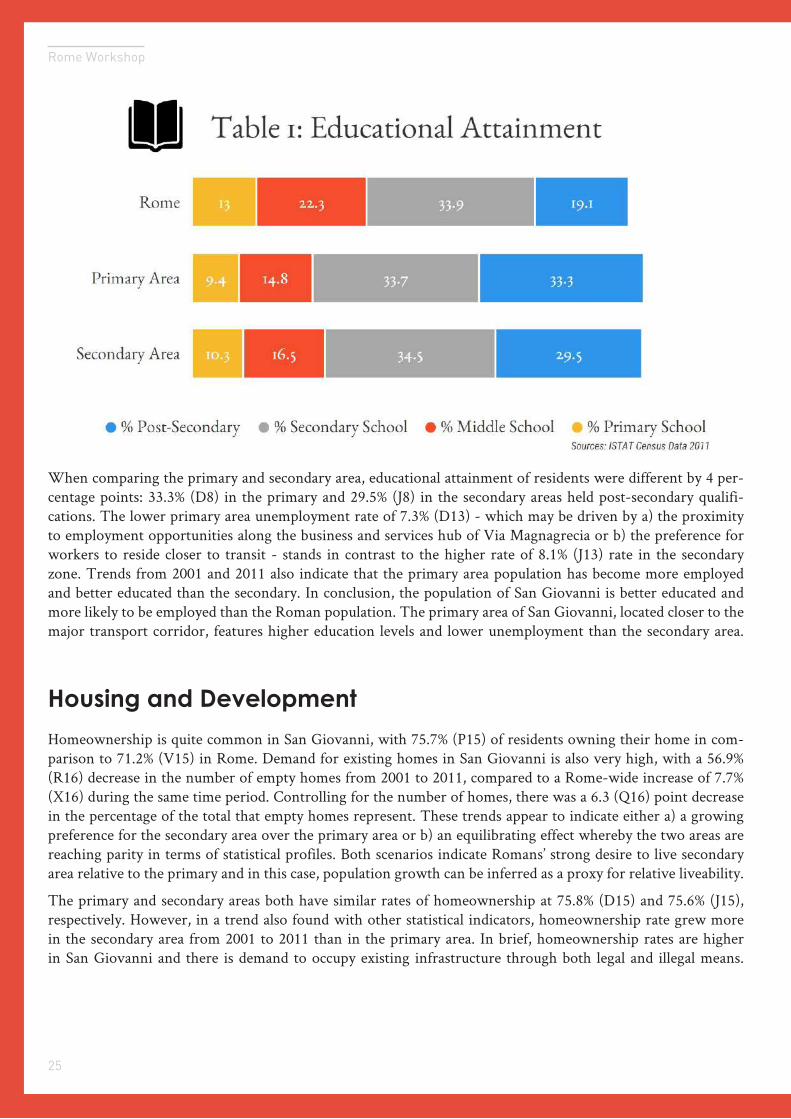
Residents of San Giovanni are on average better educated than Romans, with 30.6% (P8) holding post-sec-ondary qualifications compared to 19.1% (V8) citywide. From 2001 to 2011, the percentage of total residents with college degrees increased by 7.8 (Q8) percentage points in San Giovanni while in Rome the increase was smaller at 5.0 (W8) percentage points. Unemployment in San Giovanni was also lower at 7.8% (P13) com-pared to 9.5% (V13) of the city workforce. Taken together with many residents’ preferences to patronize lo-cal establishments, these data seem to indicate a positive economic outlook for the neighborhood economy.
Source: ISTAT Census Data 2011
25
Rome Workshop
When comparing the primary and secondary area, educational attainment of residents were different by 4 per-centage points: 33.3% (D8) in the primary and 29.5% (J8) in the secondary areas held post-secondary qualifi-cations. The lower primary area unemployment rate of 7.3% (D13) - which may be driven by a) the proximity to employment opportunities along the business and services hub of Via Magnagrecia or b) the preference for workers to reside closer to transit - stands in contrast to the higher rate of 8.1% (J13) rate in the secondary zone. Trends from 2001 and 2011 also indicate that the primary area population has become more employed and better educated than the secondary. In conclusion, the population of San Giovanni is better educated and more likely to be employed than the Roman population. The primary area of San Giovanni, located closer to the major transport corridor, features higher education levels and lower unemployment than the secondary area.
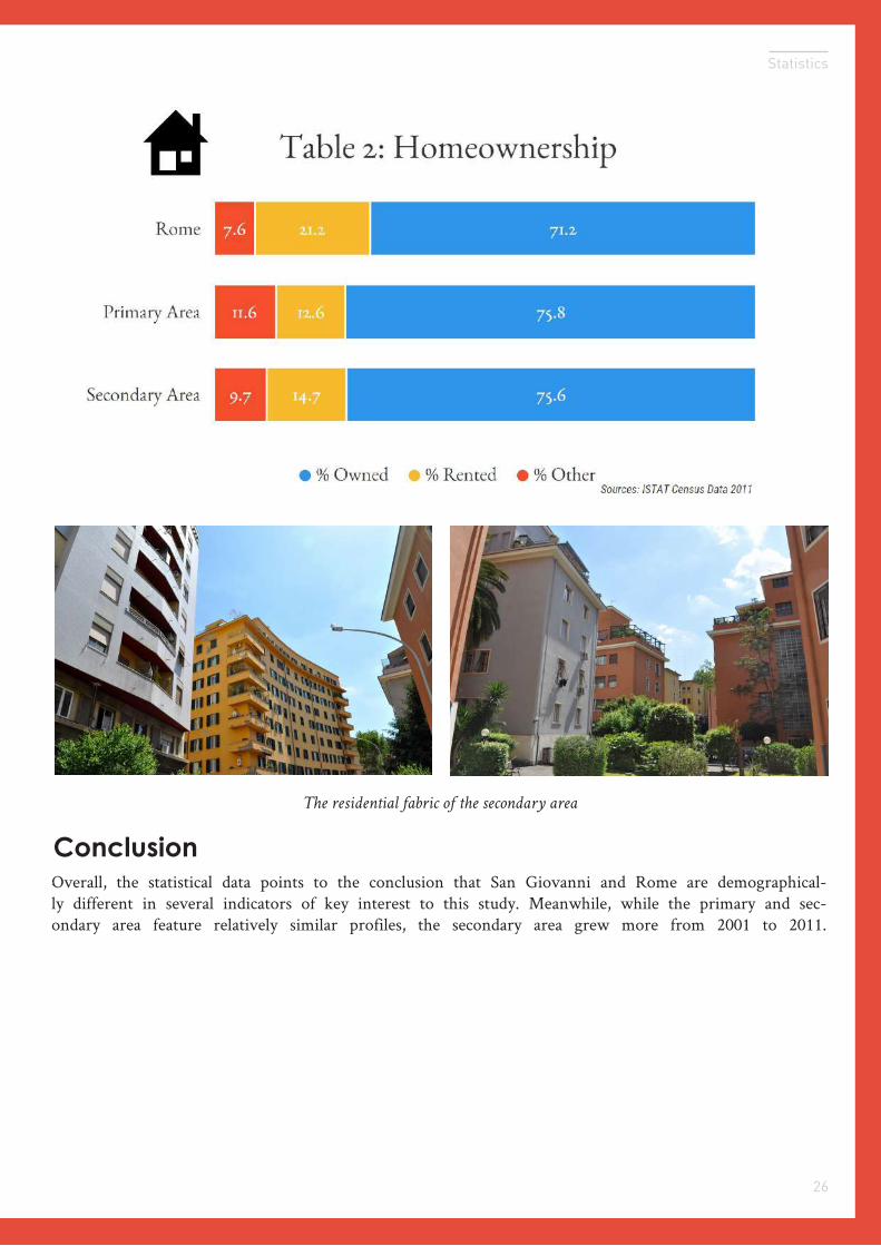
Homeownership is quite common in San Giovanni, with 75.7% (P15) of residents owning their home in com-parison to 71.2% (V15) in Rome. Demand for existing homes in San Giovanni is also very high, with a 56.9% (R16) decrease in the number of empty homes from 2001 to 2011, compared to a Rome-wide increase of 7.7% (X16) during the same time period. Controlling for the number of homes, there was a 6.3 (Q16) point decrease in the percentage of the total that empty homes represent. These trends appear to indicate either a) a growing preference for the secondary area over the primary area or b) an equilibrating effect whereby the two areas are reaching parity in terms of statistical profiles. Both scenarios indicate Romans’ strong desire to live secondary area relative to the primary and in this case, population growth can be inferred as a proxy for relative liveability.
The primary and secondary areas both have similar rates of homeownership at 75.8% (D15) and 75.6% (J15), respectively. However, in a trend also found with other statistical indicators, homeownership rate grew more in the secondary area from 2001 to 2011 than in the primary area. In brief, homeownership rates are higher in San Giovanni and there is demand to occupy existing infrastructure through both legal and illegal means.
Housing and Development
26
Statistics
Overall, the statistical data points to the conclusion that San Giovanni and Rome are demographical-ly different in several indicators of key interest to this study. Meanwhile, while the primary and sec-ondary area feature relatively similar profiles, the secondary area grew more from 2001 to 2011.
Conclusion
The residential fabric of the secondary area
Built Form03
How San Giovanni’s buildings, spaces, and paths affect livability
Rome Workshop
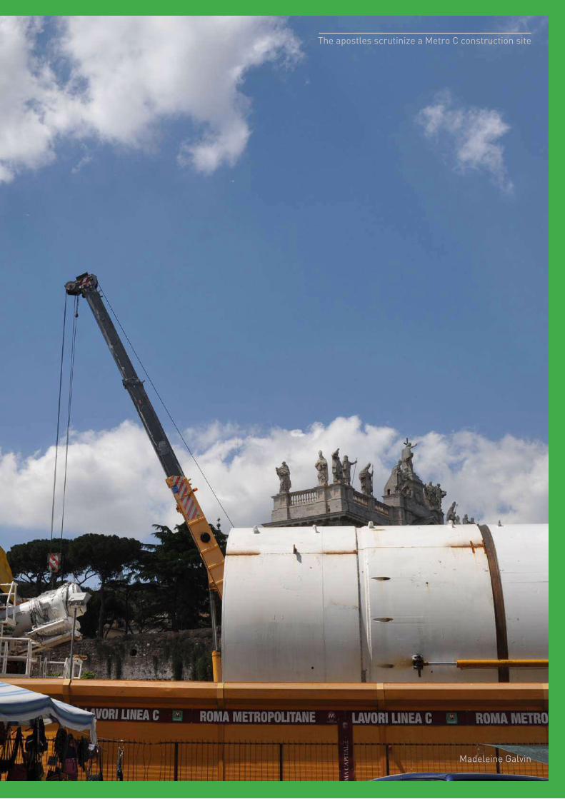
Image Credit
The apostles scrutinize a Metro C construction site
Madeleine Galvin
29
Rome Workshop
1Buildings
Architectural Styles
Building Typologies
2Spaces
Public Spaces
Porta San Giovanni Transit Node
3Paths
Sidewalk Use
Flows
Street Typologies
Introduction
What role does the built form of a city play in the daily lives of its inhabitants? Are these physical features more or less important in determining livability than social ones?
?
While every urbanite will likely answer differently, the planner is interested in determining which infrastructural elements or social structures most directly affect the quality of life of these city-dwellers. She might better apply her efforts if these questions were answered.
This section examines San Giovanni’s built form, in the hopes of shedding some light on our guiding questions. We classify the built form in three parts: buildings, spaces, and paths. (The grid, plumbing, telecommunications networks, and other such infrastructures are left out of this analysis.)
30
Built Form
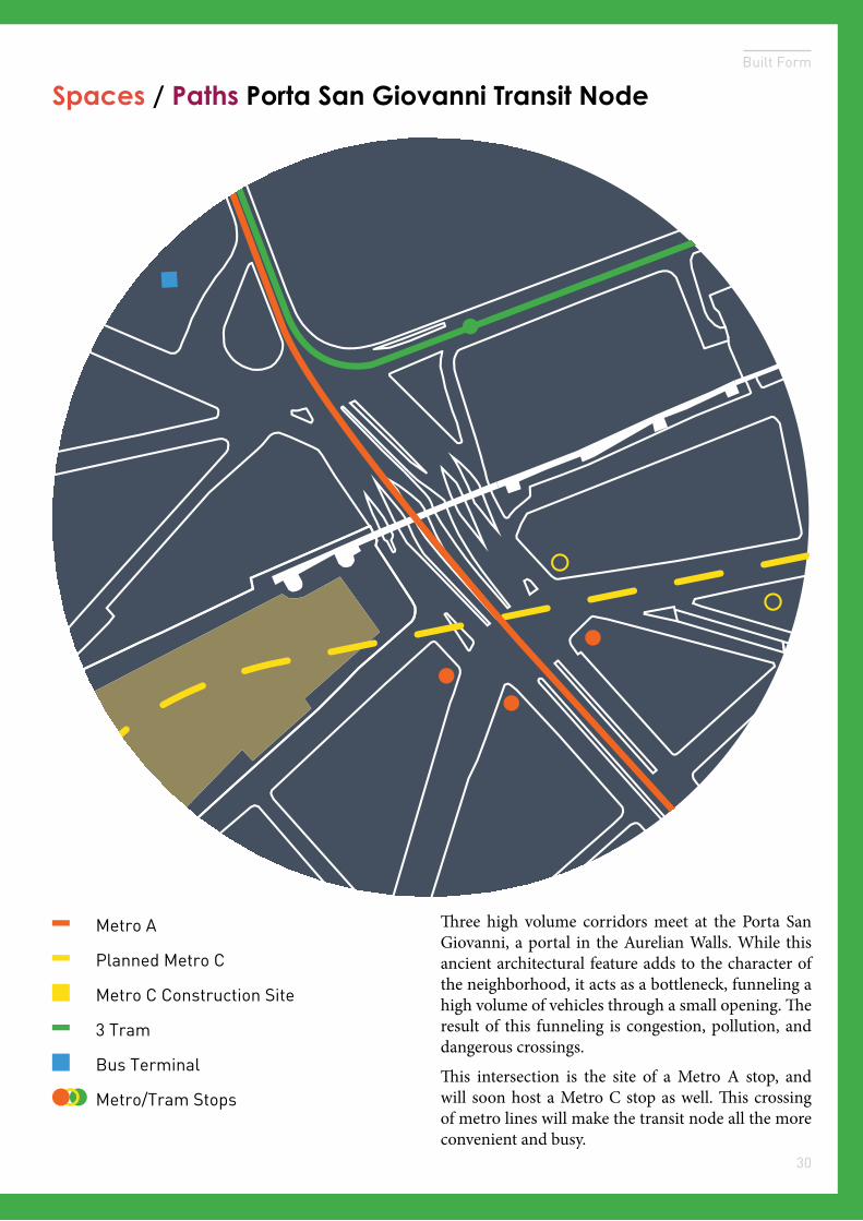
Spaces / Paths Porta San Giovanni Transit Node
Three high volume corridors meet at the Porta San Giovanni, a portal in the Aurelian Walls. While this ancient architectural feature adds to the character of the neighborhood, it acts as a bottleneck, funneling a high volume of vehicles through a small opening. The result of this funneling is congestion, pollution, and dangerous crossings.
This intersection is the site of a Metro A stop, and will soon host a Metro C stop as well. This crossing of metro lines will make the transit node all the more convenient and busy.
Metro A
Planned Metro C
Metro C Construction Site
3 Tram
Bus Terminal
Metro/Tram Stops
31
Rome Workshop
Buildings Typologies
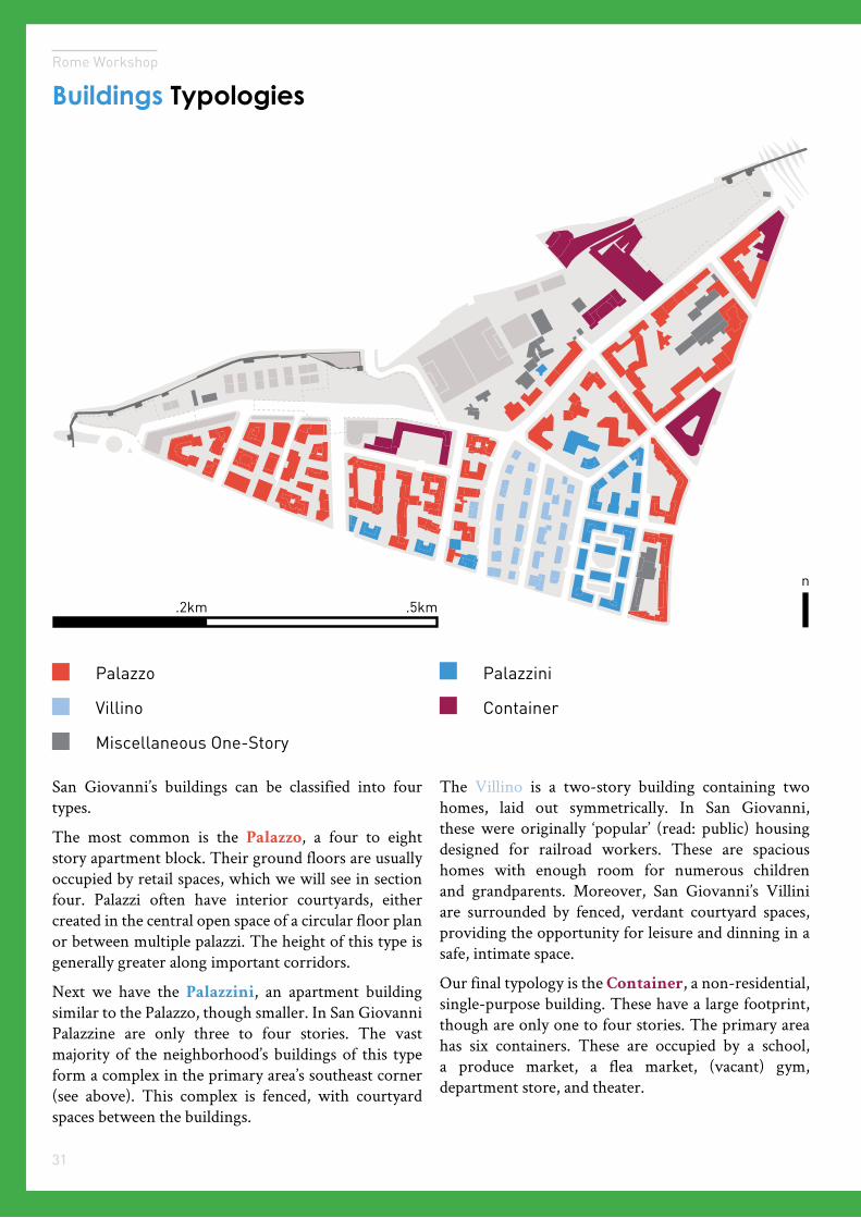
San Giovanni’s buildings can be classified into four types.
The most common is the Palazzo, a four to eight story apartment block. Their ground floors are usually occupied by retail spaces, which we will see in section four. Palazzi often have interior courtyards, either created in the central open space of a circular floor plan or between multiple palazzi. The height of this type is generally greater along important corridors.
Next we have the Palazzini, an apartment building similar to the Palazzo, though smaller. In San Giovanni Palazzine are only three to four stories. The vast majority of the neighborhood’s buildings of this type form a complex in the primary area’s southeast corner (see above). This complex is fenced, with courtyard spaces between the buildings.
The Villino is a two-story building containing two homes, laid out symmetrically. In San Giovanni, these were originally ‘popular’ (read: public) housing designed for railroad workers. These are spacious homes with enough room for numerous children and grandparents. Moreover, San Giovanni’s Villini are surrounded by fenced, verdant courtyard spaces, providing the opportunity for leisure and dinning in a safe, intimate space.
Our final typology is the Container, a non-residential, single-purpose building. These have a large footprint, though are only one to four stories. The primary area has six containers. These are occupied by a school, a produce market, a flea market, (vacant) gym, department store, and theater.
n
.5km.2km
Palazzo
Villino
Palazzini
Container
Miscellaneous One-Story
32
Built Form
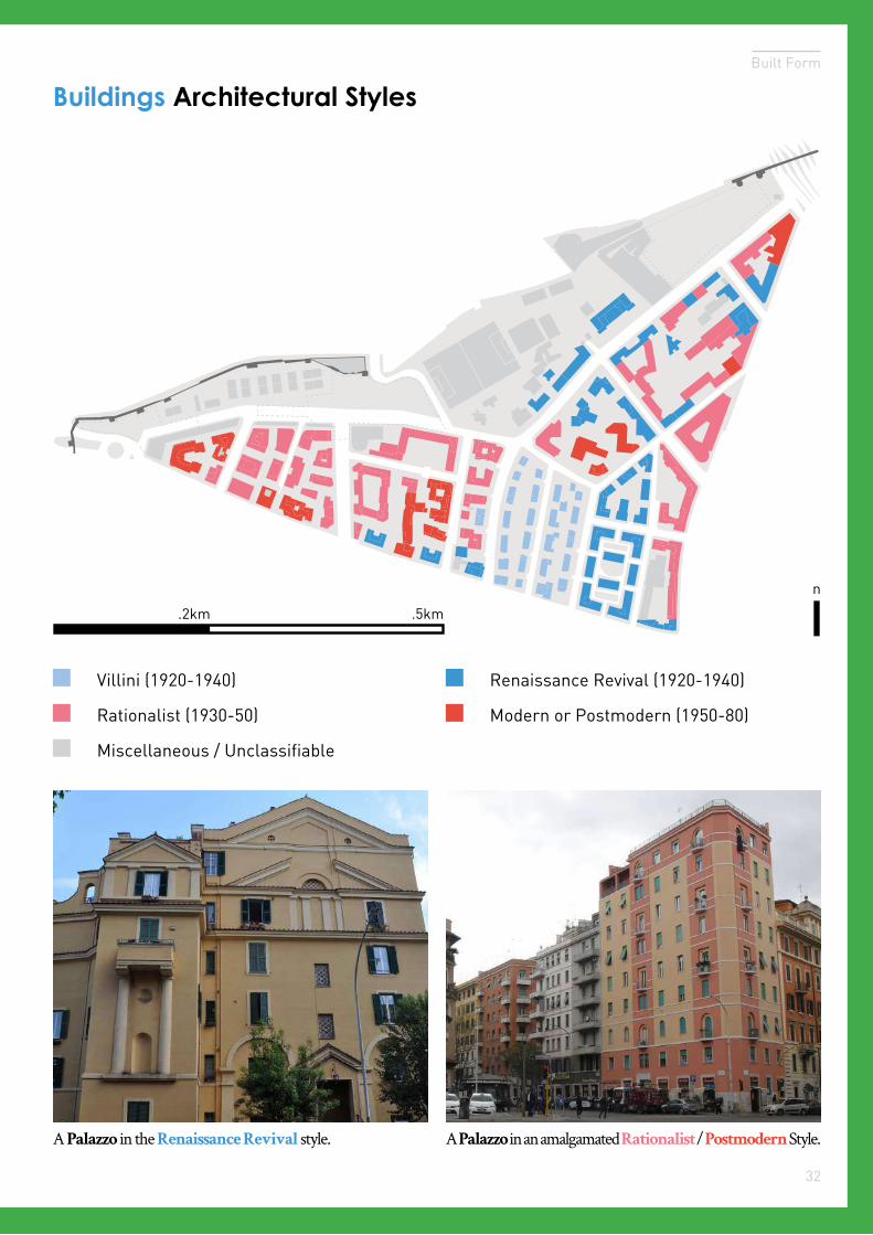
Buildings Architectural Styles
.5km.2km
Villini (1920-1940)
Rationalist (1930-50)
Renaissance Revival (1920-1940)
Modern or Postmodern (1950-80)
Miscellaneous / Unclassifiable
n
A Palazzo in the Renaissance Revival style. A Palazzo in an amalgamated Rationalist / Postmodern Style.
33
Rome Workshop
Public Spaces
Public Space
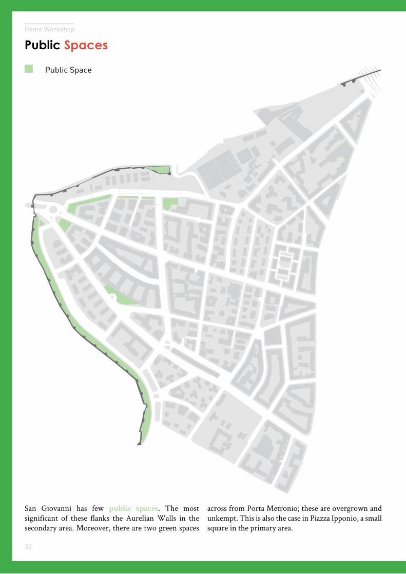
San Giovanni has few public spaces. The most significant of these flanks the Aurelian Walls in the secondary area. Moreover, there are two green spaces
across from Porta Metronio; these are overgrown and unkempt. This is also the case in Piazza Ipponio, a small square in the primary area.
34
Built Form
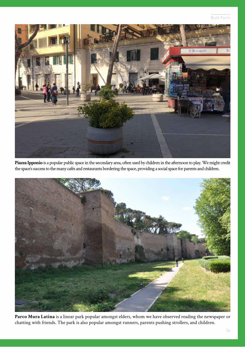
Parco Mura Latina is a linear park popular amongst elders, whom we have observed reading the newspaper or chatting with friends. The park is also popular amongst runners, parents pushing strollers, and children.
Piazza Ipponio is a popular public space in the secondary area, often used by children in the afternoon to play. We might credit the space’s success to the many cafés and restaurants bordering the space, providing a social space for parents and children.
35
Rome Workshop
.5km.2km
n
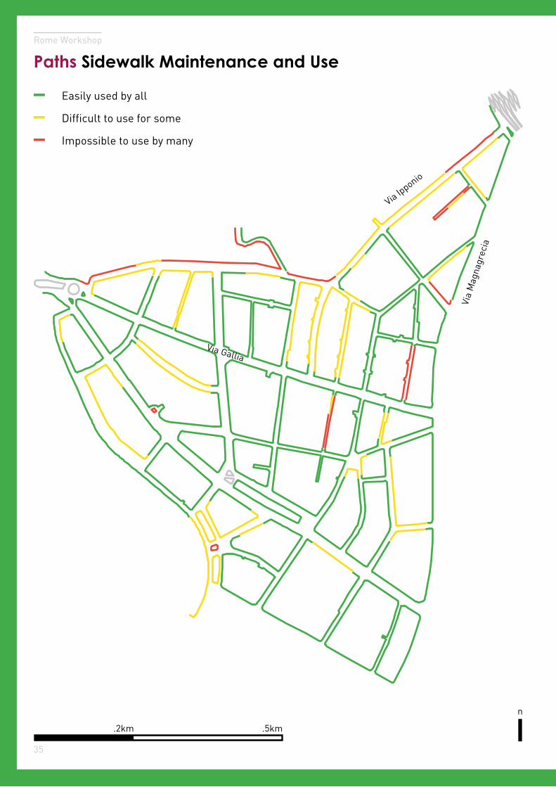
Paths Sidewalk Maintenance and Use
Easily used by all
Difficult to use for some
Impossible to use by many
Via Ipponio
Via Gallia
Via
Mag
nagr
ecia
36
Built Form
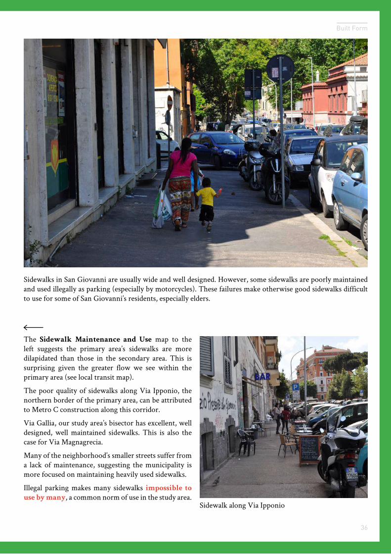
Sidewalks in San Giovanni are usually wide and well designed. However, some sidewalks are poorly maintained and used illegally as parking (especially by motorcycles). These failures make otherwise good sidewalks difficult to use for some of San Giovanni’s residents, especially elders.
The Sidewalk Maintenance and Use map to the left suggests the primary area’s sidewalks are more dilapidated than those in the secondary area. This is surprising given the greater flow we see within the primary area (see local transit map).
The poor quality of sidewalks along Via Ipponio, the northern border of the primary area, can be attributed to Metro C construction along this corridor.
Via Gallia, our study area’s bisector has excellent, well designed, well maintained sidewalks. This is also the case for Via Magnagrecia.
Many of the neighborhood’s smaller streets suffer from a lack of maintenance, suggesting the municipality is more focused on maintaining heavily used sidewalks.
Illegal parking makes many sidewalks impossible to
use by many, a common norm of use in the study area.Sidewalk along Via Ipponio
37
Rome Workshop
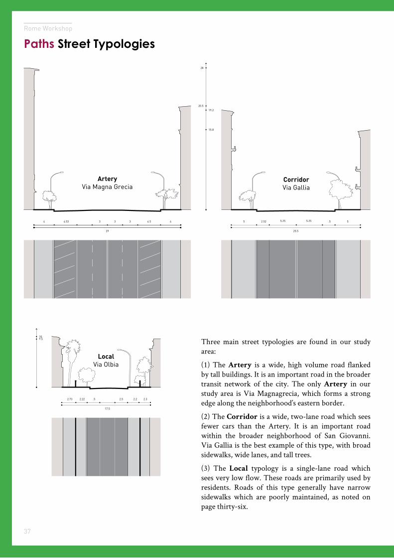
Paths Street Typologies
4 44.54.53 333
29
5 52.52 .55.25
25.5
20.5
28
19.2
15.8
5.25
CorridorVia Gallia
ArteryVia Magna Grecia
2.32.22.73 2.22 .5
17.5
2.5
109.5
LocalVia Olbia
Three main street typologies are found in our study area:
(1) The Artery is a wide, high volume road flanked by tall buildings. It is an important road in the broader transit network of the city. The only Artery in our study area is Via Magnagrecia, which forms a strong edge along the neighborhood’s eastern border.
(2) The Corridor is a wide, two-lane road which sees fewer cars than the Artery. It is an important road within the broader neighborhood of San Giovanni. Via Gallia is the best example of this type, with broad sidewalks, wide lanes, and tall trees.
(3) The Local typology is a single-lane road which sees very low flow. These roads are primarily used by residents. Roads of this type generally have narrow sidewalks which are poorly maintained, as noted on page thirty-six.
38
Built Form
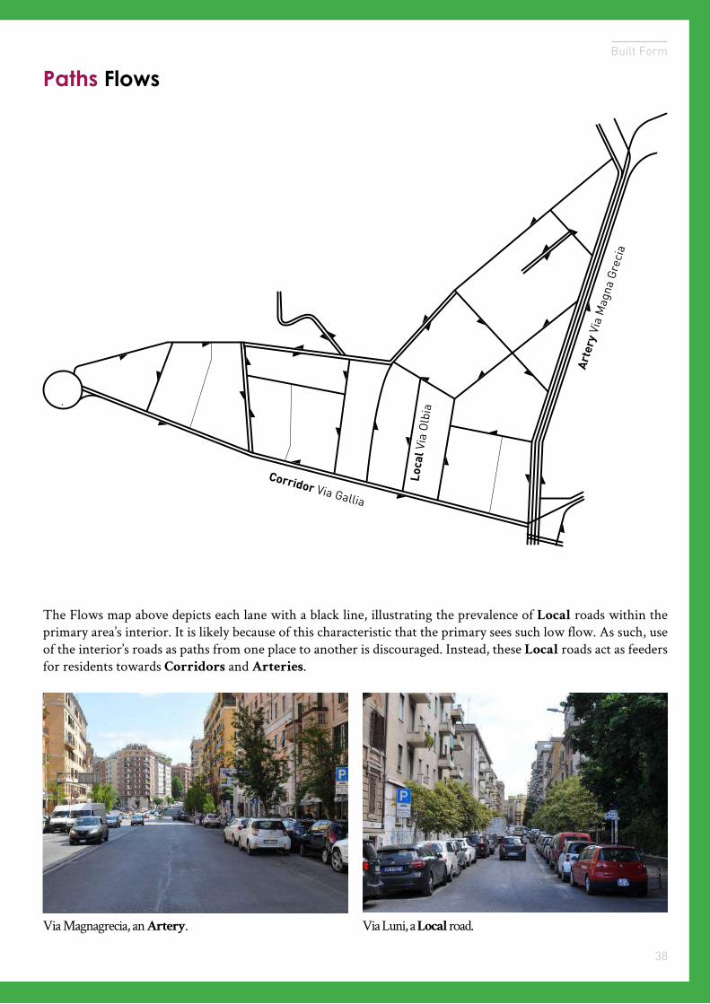
Paths Flows
Arte
ry V
ia M
agna
Gre
cia
Corridor Via Gallia
Loca
l Via
Olb
ia
The Flows map above depicts each lane with a black line, illustrating the prevalence of Local roads within the primary area’s interior. It is likely because of this characteristic that the primary sees such low flow. As such, use of the interior’s roads as paths from one place to another is discouraged. Instead, these Local roads act as feeders for residents towards Corridors and Arteries.
Via Magnagrecia, an Artery. Via Luni, a Local road.
Services04
Rome Workshop
Transit-oriented development impacts on the neighborhood service mix.
Image Credit
Image Subject
45
Rome Workshop
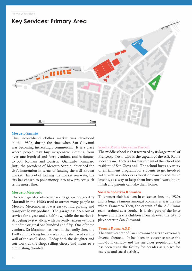
Key Services: Primary Area
Mercato Sannio
This second-hand clothes market was developed in the 1950’s, during the time when San Giovanni was becoming increasingly commercial. It is a place where people may buy inexpensive clothing from over one hundred and forty vendors, and is famous to both Romans and tourists. Giancarlo Tommaso Justi, the president of Mercato Sannio, described the city’s inattention in terms of funding the well-known market. Instead of helping the market renovate, the city has chosen to pour money into new projects such as the metro line.
Mercato Metronio
The avant-garde corkscrew parking garage designed by Morandi in the 1950’s used to attract many people to Mercato Metronio, as it was easy to find parking and transport heavy produce. The garage has been out of service for a year and a half now, while the market is struggling to stay afloat with currently sixteen vendors out of the original one hundred and fifty. One of these vendors, Da Massimo, has been in the family since the 1960’s and its long history is proudly displayed on the wall of the small shop. Today both the daughter and son work at the shop, selling cheese and meats to a diminishing clientele.
.5km.2km
Scuola Media Giovanni Pascoli
The middle school is characterized by its large mural of Francesco Totti, who is the captain of the A.S. Roma soccer team. Totti is a former student of the school and resident of San Giovanni. The school hosts a variety of enrichment programs for students to get involved with, such as outdoors exploration courses and music lessons, as a way to keep them busy until work hours finish and parents can take them home.
Societa Sportiva Romulea
This soccer club has been in existence since the 1920’s and is hugely famous amongst Romans as it is the site where Francesco Totti, the captain of the A.S. Roma team, trained as a youth. It is also part of the Inter league and attracts children from all over the city to play soccer in San Giovanni.
Tennis Roma A.S.D
The tennis center of San Giovanni boasts an extremely diverse clientele. It has been in existence since the mid-20th century and has an older population that has been using the facility for decades as a place for exercise and social activity.
46
Services
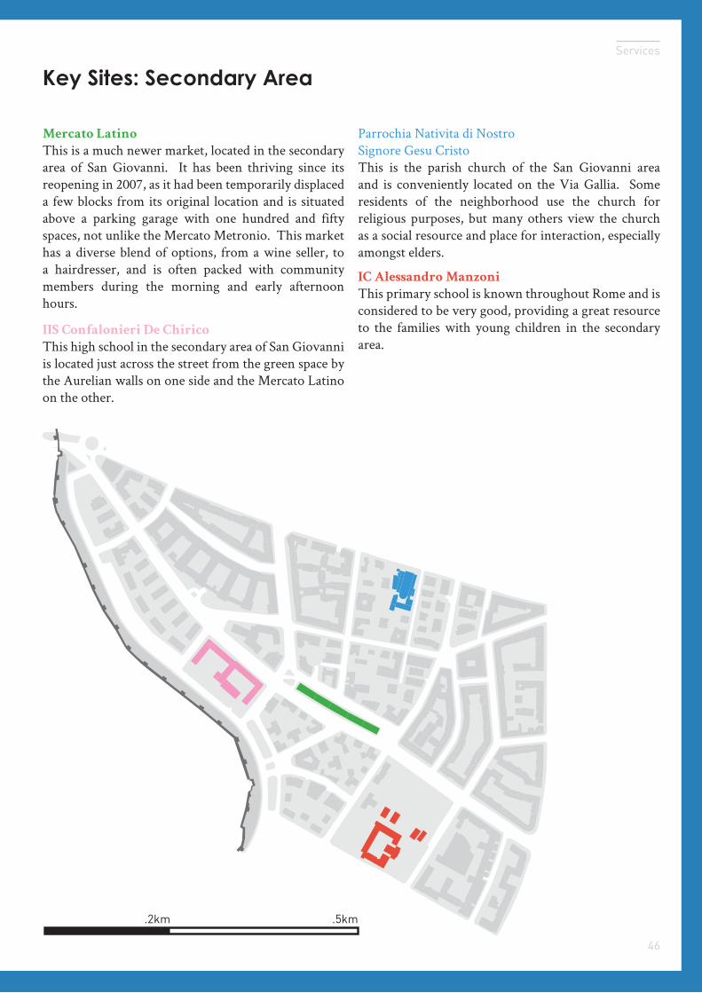
Key Sites: Secondary Area
.5km.2km
Mercato Latino
This is a much newer market, located in the secondary area of San Giovanni. It has been thriving since its reopening in 2007, as it had been temporarily displaced a few blocks from its original location and is situated above a parking garage with one hundred and fifty spaces, not unlike the Mercato Metronio. This market has a diverse blend of options, from a wine seller, to a hairdresser, and is often packed with community members during the morning and early afternoon hours.
Parrochia Nativita di Nostro Signore Gesu CristoThis is the parish church of the San Giovanni area and is conveniently located on the Via Gallia. Some residents of the neighborhood use the church for religious purposes, but many others view the church as a social resource and place for interaction, especially amongst elders.
IIS Confalonieri De Chirico
This high school in the secondary area of San Giovanni is located just across the street from the green space by the Aurelian walls on one side and the Mercato Latino on the other.
IC Alessandro Manzoni
This primary school is known throughout Rome and is considered to be very good, providing a great resource to the families with young children in the secondary area.

47
Rome Workshop
The San Giovanni neighborhood has a wide variety of services that range from everyday, community-targeted grocery stores to a department store and a tennis club that attract people from all over the city. Adjacent to the main transit corridor on Via Magnagrecia, the primary area of San Giovanni has a great number of commercial services that cater to the transient population. This focus on commercial activity might have a negative impact on the livability of the primary area, as transient users are less interested in the quality of the neighborhood. In one of the intercept interviews, a flower shop keeper on Via Gallia said that he walks from the Metro along Via Sannio to get to his business every day yet does not care much about the quality of the street, let alone make an effort to improve it. On the other hand, the secondary area has more community-targeted services and institutions that contribute to keeping the neighborhood livable as well as maintaining a stronger sense of community among its residents.
Summary
48
Services
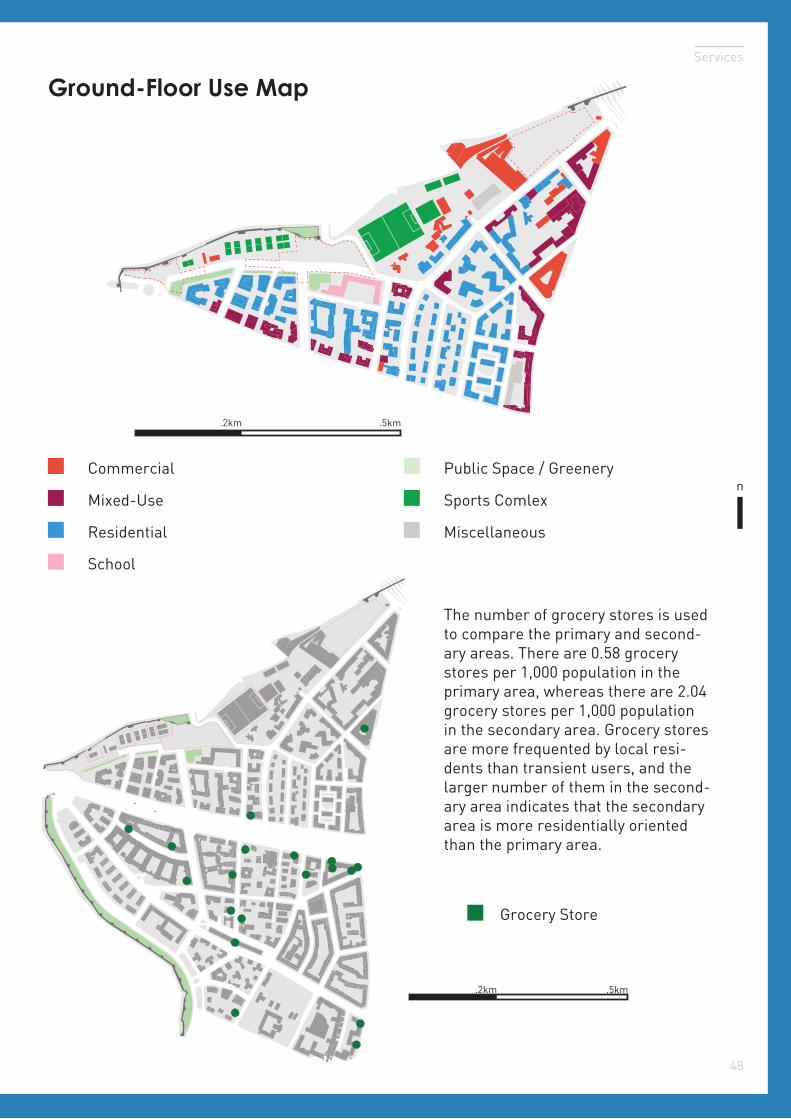
Ground-Floor Use Map
n
.5km.2km
School
Commercial
Residential Miscellaneous
Mixed-Use Sports Comlex
Public Space / Greenery
Grocery Store
.2km .5km
The number of grocery stores is used to compare the primary and second-ary areas. There are 0.58 grocery stores per 1,000 population in the primary area, whereas there are 2.04 grocery stores per 1,000 population in the secondary area. Grocery stores are more frequented by local resi-dents than transient users, and the larger number of them in the second-ary area indicates that the secondary area is more residentially oriented than the primary area.
49
Rome Workshop
Primary Area
n
.5km.2km
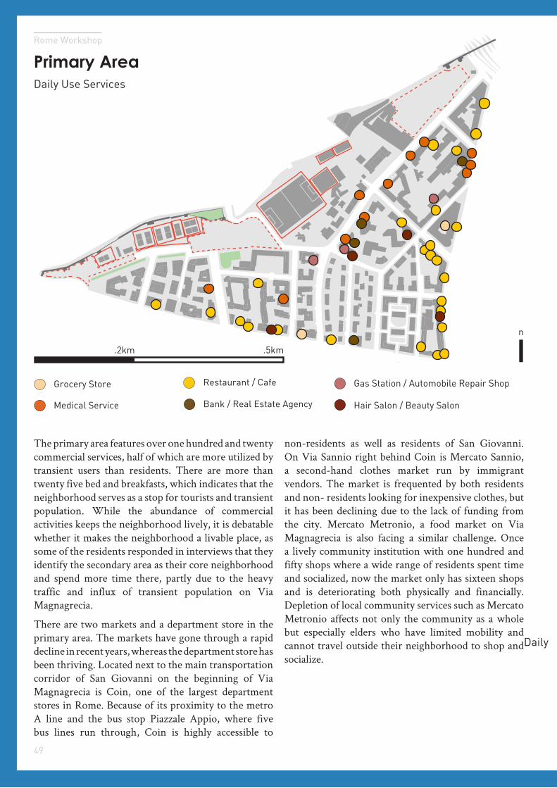
The primary area features over one hundred and twenty commercial services, half of which are more utilized by transient users than residents. There are more than twenty five bed and breakfasts, which indicates that the neighborhood serves as a stop for tourists and transient population. While the abundance of commercial activities keeps the neighborhood lively, it is debatable whether it makes the neighborhood a livable place, as some of the residents responded in interviews that they identify the secondary area as their core neighborhood and spend more time there, partly due to the heavy traffic and influx of transient population on Via Magnagrecia.
There are two markets and a department store in the primary area. The markets have gone through a rapid decline in recent years, whereas the department store has been thriving. Located next to the main transportation corridor of San Giovanni on the beginning of Via Magnagrecia is Coin, one of the largest department stores in Rome. Because of its proximity to the metro A line and the bus stop Piazzale Appio, where five bus lines run through, Coin is highly accessible to
non-residents as well as residents of San Giovanni. On Via Sannio right behind Coin is Mercato Sannio, a second-hand clothes market run by immigrant vendors. The market is frequented by both residents and non- residents looking for inexpensive clothes, but it has been declining due to the lack of funding from the city. Mercato Metronio, a food market on Via Magnagrecia is also facing a similar challenge. Once a lively community institution with one hundred and fifty shops where a wide range of residents spent time and socialized, now the market only has sixteen shops and is deteriorating both physically and financially. Depletion of local community services such as Mercato Metronio affects not only the community as a whole but especially elders who have limited mobility and cannot travel outside their neighborhood to shop and socialize.
Hair Salon / Beauty Salon
Grocery Store
Daily Use Services
Gas Station / Automobile Repair Shop
Bank / Real Estate AgencyMedical Service
Restaurant / Cafe
Daily
50
Services
Hair Salon / Beauty Salon
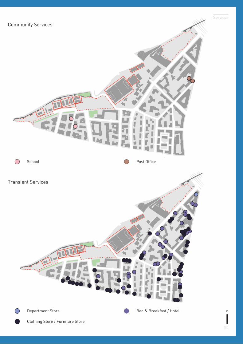
Post OfficeSchool
n
Community Services
Transient Services
Bed & Breakfast / HotelDepartment Store
Clothing Store / Furniture Store
51
Rome Workshop
n
.5km.2km
Hair Salon / Beauty Salon
Grocery Store Gas Station / Automobile Repair Shop
Bank / Real Estate AgencyMedical Service
Restaurant / Cafe
SchoolElders’ Center Post Office
Nursing Home Church
Daily Use
Community
52
Services
Secondary Area
n
.5km
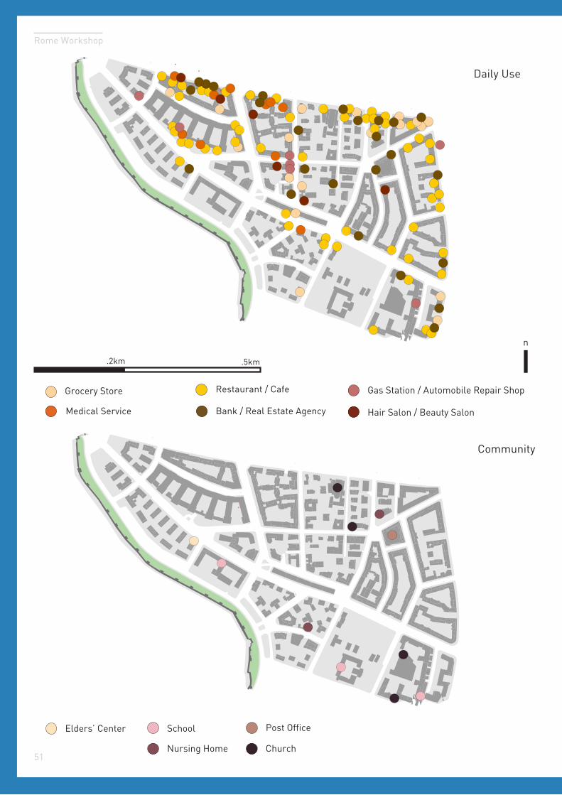
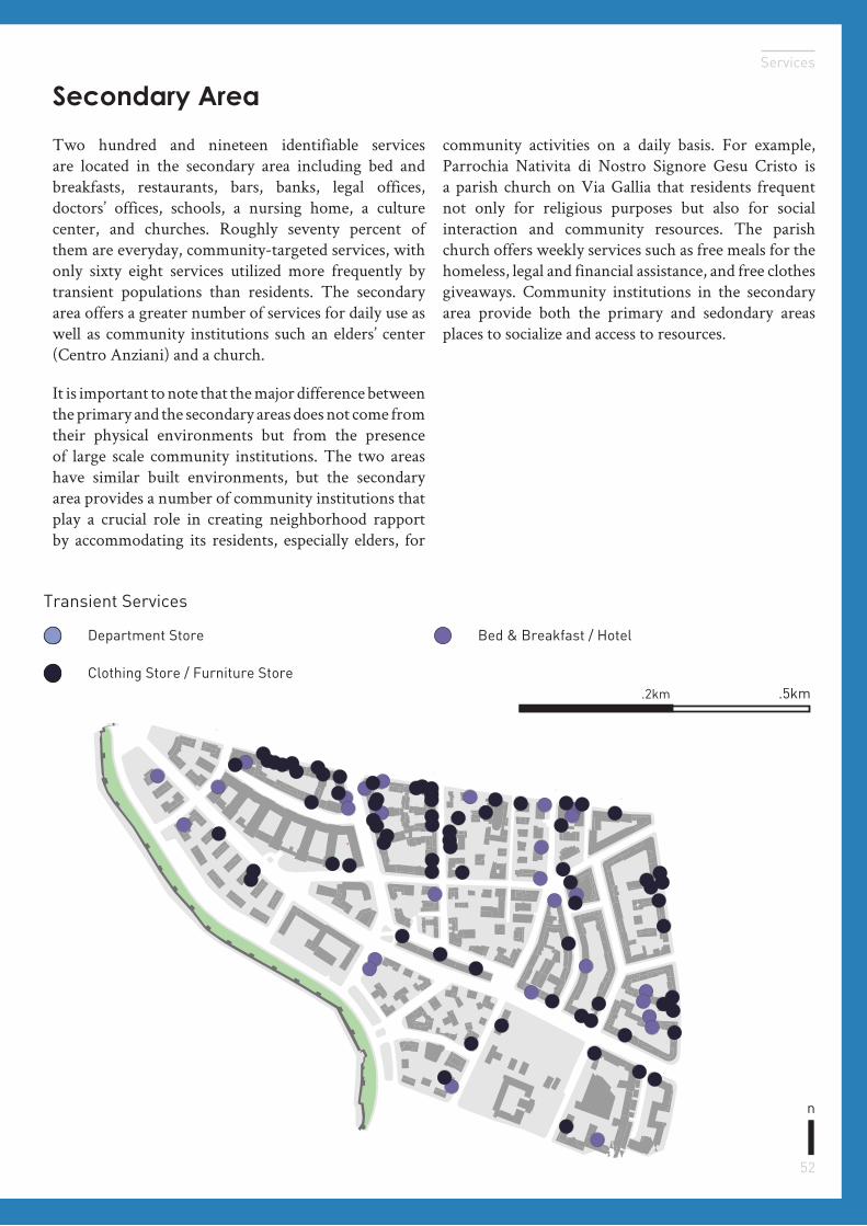
Two hundred and nineteen identifiable services are located in the secondary area including bed and breakfasts, restaurants, bars, banks, legal offices, doctors’ offices, schools, a nursing home, a culture center, and churches. Roughly seventy percent of them are everyday, community-targeted services, with only sixty eight services utilized more frequently by transient populations than residents. The secondary area offers a greater number of services for daily use as well as community institutions such an elders’ center (Centro Anziani) and a church.
It is important to note that the major difference between the primary and the secondary areas does not come from their physical environments but from the presence of large scale community institutions. The two areas have similar built environments, but the secondary area provides a number of community institutions that play a crucial role in creating neighborhood rapport by accommodating its residents, especially elders, for
community activities on a daily basis. For example, Parrochia Nativita di Nostro Signore Gesu Cristo is a parish church on Via Gallia that residents frequent not only for religious purposes but also for social interaction and community resources. The parish church offers weekly services such as free meals for the homeless, legal and financial assistance, and free clothes giveaways. Community institutions in the secondary area provide both the primary and sedondary areas places to socialize and access to resources.
Bed & Breakfast / HotelDepartment Store
Clothing Store / Furniture Store.2km
Transient Services
Engagement05
Rome Workshop
Engaging the residents of San Giovanni to gather insight on how the neighborhood works
Image Subject
Image CreditBrooke Shin
Mario Spada maps
55
Rome Workshop
Livability Audit
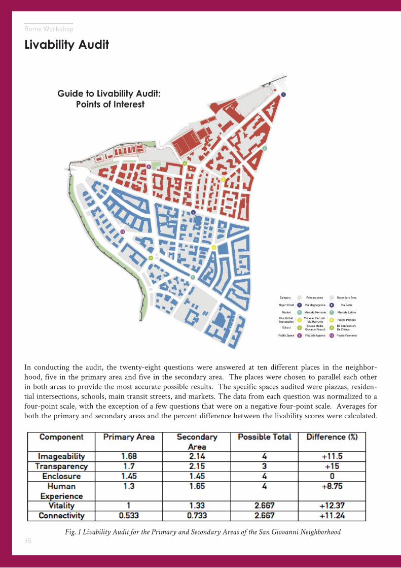
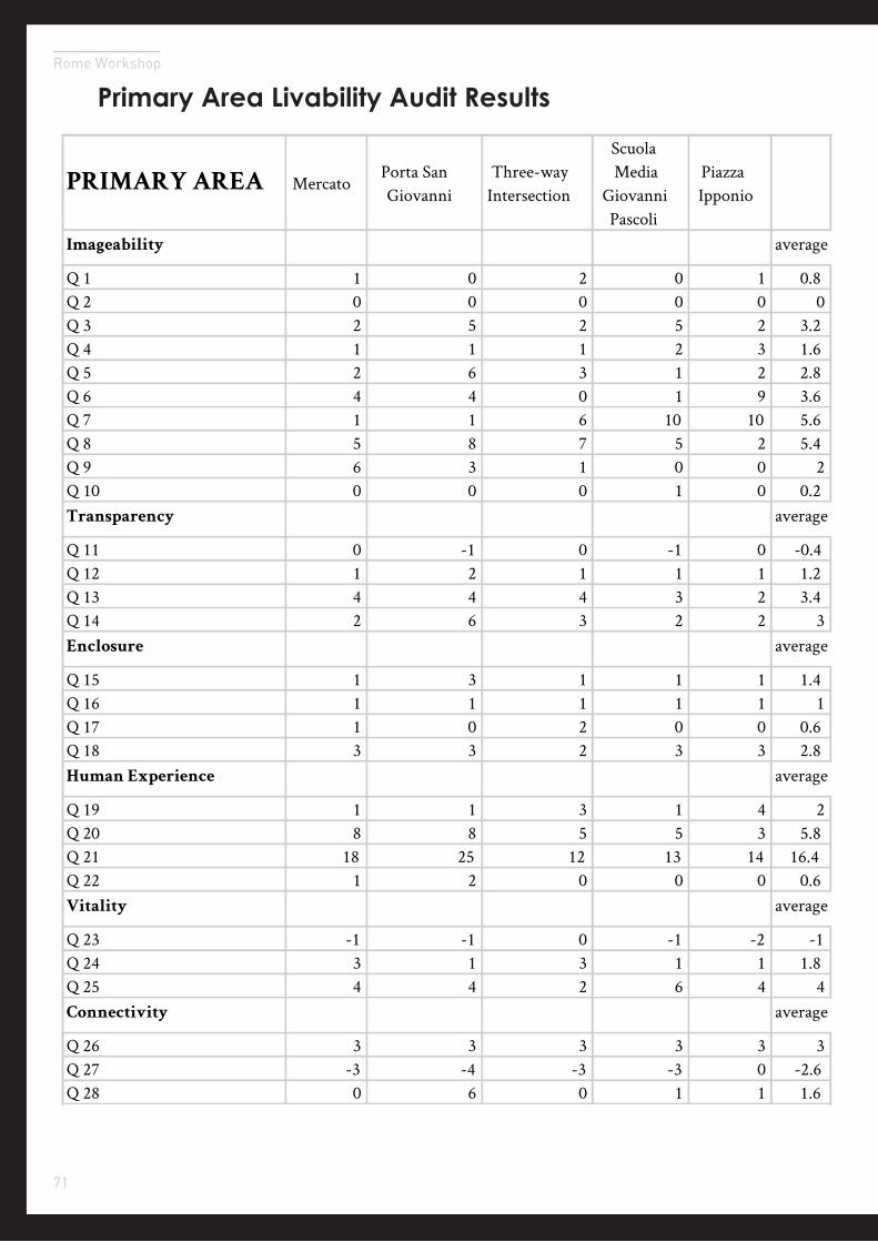
In conducting the audit, the twenty-eight questions were answered at ten different places in the neighbor-hood, five in the primary area and five in the secondary area. The places were chosen to parallel each other in both areas to provide the most accurate possible results. The specific spaces audited were piazzas, residen-tial intersections, schools, main transit streets, and markets. The data from each question was normalized to a four-point scale, with the exception of a few questions that were on a negative four-point scale. Averages for both the primary and secondary areas and the percent difference between the livability scores were calculated.
Fig. 1 Livability Audit for the Primary and Secondary Areas of the San Giovanni Neighborhood
56
Engagement
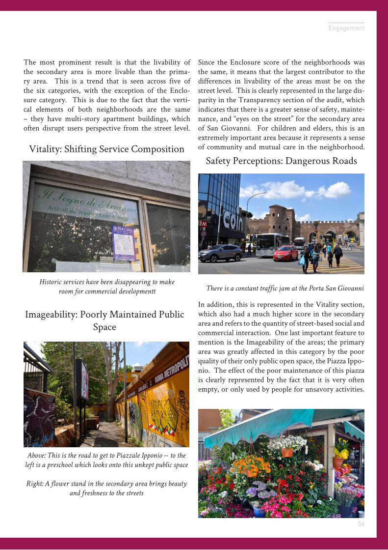
The most prominent result is that the livability of the secondary area is more livable than the prima-ry area. This is a trend that is seen across five of the six categories, with the exception of the Enclo-sure category. This is due to the fact that the verti-cal elements of both neighborhoods are the same – they have multi-story apartment buildings, which often disrupt users perspective from the street level.
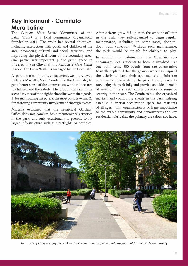
Above: This is the road to get to Piazzale Ipponio -- to the
left is a preschool which looks onto this unkept public space
Right: A flower stand in the secondary area brings beauty
and freshness to the streets
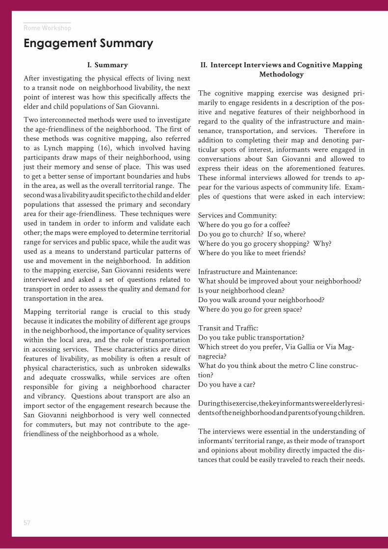
There is a constant traffic jam at the Porta San Giovanni
Historic services have been disappearing to make
room for commercial developmentt
Imageability: Poorly Maintained Public Space
Vitality: Shifting Service CompositionSafety Perceptions: Dangerous Roads
Since the Enclosure score of the neighborhoods was the same, it means that the largest contributor to the differences in livability of the areas must be on the street level. This is clearly represented in the large dis-parity in the Transparency section of the audit, which indicates that there is a greater sense of safety, mainte-nance, and “eyes on the street” for the secondary area of San Giovanni. For children and elders, this is an extremely important area because it represents a sense of community and mutual care in the neighborhood.
In addition, this is represented in the Vitality section, which also had a much higher score in the secondary area and refers to the quantity of street-based social and commercial interaction. One last important feature to mention is the Imageability of the areas; the primary area was greatly affected in this category by the poor quality of their only public open space, the Piazza Ippo-nio. The effect of the poor maintenance of this piazza is clearly represented by the fact that it is very often empty, or only used by people for unsavory activities.
57
Rome Workshop
I. Summary
After investigating the physical effects of living next to a transit node on neighborhood livability, the next point of interest was how this specifically affects the elder and child populations of San Giovanni.
Two interconnected methods were used to investigate the age-friendliness of the neighborhood. The first of these methods was cognitive mapping, also referred to as Lynch mapping (16), which involved having participants draw maps of their neighborhood, using just their memory and sense of place. This was used to get a better sense of important boundaries and hubs in the area, as well as the overall territorial range. The second was a livability audit specific to the child and elder populations that assessed the primary and secondary area for their age-friendliness. These techniques were used in tandem in order to inform and validate each other; the maps were employed to determine territorial range for services and public space, while the audit was used as a means to understand particular patterns of use and movement in the neighborhood. In addition to the mapping exercise, San Giovanni residents were interviewed and asked a set of questions related to transport in order to assess the quality and demand for transportation in the area.
Mapping territorial range is crucial to this study because it indicates the mobility of different age groups in the neighborhood, the importance of quality services within the local area, and the role of transportation in accessing services. These characteristics are direct features of livability, as mobility is often a result of physical characteristics, such as unbroken sidewalks and adequate crosswalks, while services are often responsible for giving a neighborhood character and vibrancy. Questions about transport are also an import sector of the engagement research because the San Giovanni neighborhood is very well connected for commuters, but may not contribute to the age-friendliness of the neighborhood as a whole.
Engagement Summary
II. Intercept Interviews and Cognitive Mapping
Methodology
The cognitive mapping exercise was designed pri-marily to engage residents in a description of the pos-itive and negative features of their neighborhood in regard to the quality of the infrastructure and main-tenance, transportation, and services. Therefore in addition to completing their map and denoting par-ticular spots of interest, informants were engaged in conversations about San Giovanni and allowed to express their ideas on the aforementioned features. These informal interviews allowed for trends to ap-pear for the various aspects of community life. Exam-ples of questions that were asked in each interview:
Services and Community:Where do you go for a coffee?Do you go to church? If so, where?Where do you go grocery shopping? Why?Where do you like to meet friends?
Infrastructure and Maintenance:What should be improved about your neighborhood?Is your neighborhood clean?Do you walk around your neighborhood?Where do you go for green space?
Transit and Traffic:Do you take public transportation?Which street do you prefer, Via Gallia or Via Mag-nagrecia?What do you think about the metro C line construc-tion?Do you have a car?
During this exercise, the key informants were elderly resi-dents of the neighborhood and parents of young children.
The interviews were essential in the understanding of informants’ territorial range, as their mode of transport and opinions about mobility directly impacted the dis-tances that could be easily traveled to reach their needs.
58
Engagement
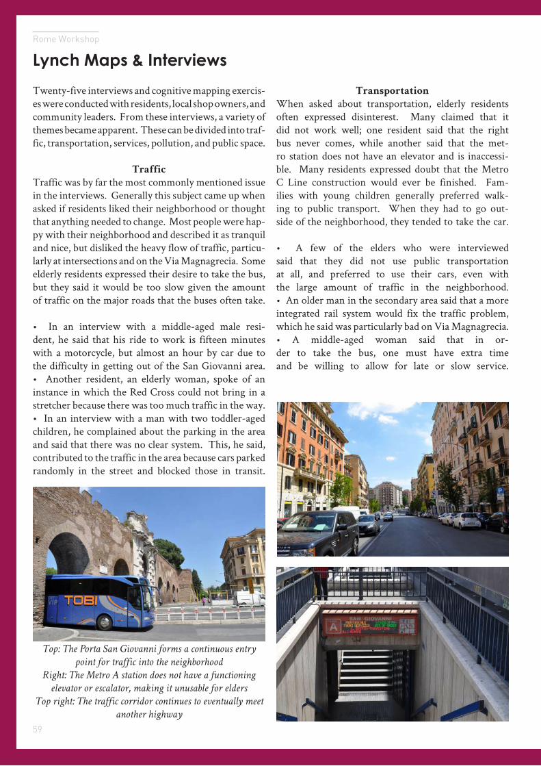
Key Informant - Comitato Mura LatineThe Comitato Mura Latine (Committee of the Latin Walls) is a local community organization founded in 2014. The group has several objectives, including interaction with youth and children of the area, promoting cultural and social activities, and improving the physical form of the secondary area. One particularly important public green space in this area of San Giovanni, the Parco delle Mura Latine (Park of the Latin Walls) is managed by the Comitato.
As part of our community engagement, we interviewed Federica Martella, Vice President of the Comitato, to get a better sense of the committee’s work as it relates to children and the elderly. The group is crucial in the secondary area of the neighborhood in two main regards: 1) for maintaining the park at the most basic level and 2) for fostering community involvement through events.
Martella explained that the municipal Gardens’ Office does not conduct basic maintenance activities in the park, and only occasionally is present to fix larger infrastructure such as streetlights or potholes.
Residents of all ages enjoy the park -- it serves as a meeting place and hangout spot for the whole community
After citizens grew fed up with the amount of litter in the park, they self-organized to begin regular maintenance, including, in some cases, door-to-door trash collection. Without such maintenance, the park would be unsafe for children to play.
In addition to maintenance, the Comitato also encourages local residents to become involved - at one point some 300 people from the community. Martella explained that the group’s work has inspired the elderly to leave their apartments and join the community in beautifying the park. Elderly residents now enjoy the park fully and provide an added benefit of ‘eyes on the street,’ which preserves a sense of security in the space. The Comitato has also organized markets and community events in the park, helping establish a critical socalization space for residents of all ages. This organization is of huge importance to the whole community and demonstrates the key residential fabric that the primary area does not have.
59
Rome Workshop
Lynch Maps & Interviews
Twenty-five interviews and cognitive mapping exercis-es were conducted with residents, local shop owners, and community leaders. From these interviews, a variety of themes became apparent. These can be divided into traf-fic, transportation, services, pollution, and public space.
Traffic
Traffic was by far the most commonly mentioned issue in the interviews. Generally this subject came up when asked if residents liked their neighborhood or thought that anything needed to change. Most people were hap-py with their neighborhood and described it as tranquil and nice, but disliked the heavy flow of traffic, particu-larly at intersections and on the Via Magnagrecia. Some elderly residents expressed their desire to take the bus, but they said it would be too slow given the amount of traffic on the major roads that the buses often take.
• In an interview with a middle-aged male resi-dent, he said that his ride to work is fifteen minutes with a motorcycle, but almost an hour by car due to the difficulty in getting out of the San Giovanni area.• Another resident, an elderly woman, spoke of an instance in which the Red Cross could not bring in a stretcher because there was too much traffic in the way.• In an interview with a man with two toddler-aged children, he complained about the parking in the area and said that there was no clear system. This, he said, contributed to the traffic in the area because cars parked randomly in the street and blocked those in transit.
Transportation
When asked about transportation, elderly residents often expressed disinterest. Many claimed that it did not work well; one resident said that the right bus never comes, while another said that the met-ro station does not have an elevator and is inaccessi-ble. Many residents expressed doubt that the Metro C Line construction would ever be finished. Fam-ilies with young children generally preferred walk-ing to public transport. When they had to go out-side of the neighborhood, they tended to take the car.
• A few of the elders who were interviewed said that they did not use public transportation at all, and preferred to use their cars, even with the large amount of traffic in the neighborhood.• An older man in the secondary area said that a more integrated rail system would fix the traffic problem, which he said was particularly bad on Via Magnagrecia.• A middle-aged woman said that in or-der to take the bus, one must have extra time and be willing to allow for late or slow service.
Top: The Porta San Giovanni forms a continuous entry
point for traffic into the neighborhood
Right: The Metro A station does not have a functioning
elevator or escalator, making it unusable for elders
Top right: The traffic corridor continues to eventually meet
another highway
60
Engagement
Services
In general, the primary area was reported to have a lack of informal meeting places, while the secondary area had more locations available for community gatherings.
• An elderly woman mentioned that she visits the elders’ center and the parish church in the secondary area to see friends. She mentioned that her husband likes to go to the tennis center to play cards with his friends, but in order to get there he takes the Via Gal-lia, as opposed to walking through the primary area.• A man with his children said there are good services for his two boys, both of whom are under ten years old. He is a resident and both kids attend the Alessandro Manzoni Primary School, which he mentioned had good sports programs. He said that he preferred these services as opposed to the soccer school in the prima-ry area because it is known for being competitive. He also said that his family goes to programs at a church in the secondary area and use the swimming pool nearby.
Interviewees often chose supermarkets for convenience of location; they are not generally considered a place to socialize but rather a place to do shopping, while the larger markets are generally more expensive, but have an aspect of human interaction that elders tended to appreciate.
• One resident said that his mother, who is eighty years old, often goes to the Mercato Metronio because it has become her habit after decades of living in San Giovanni.
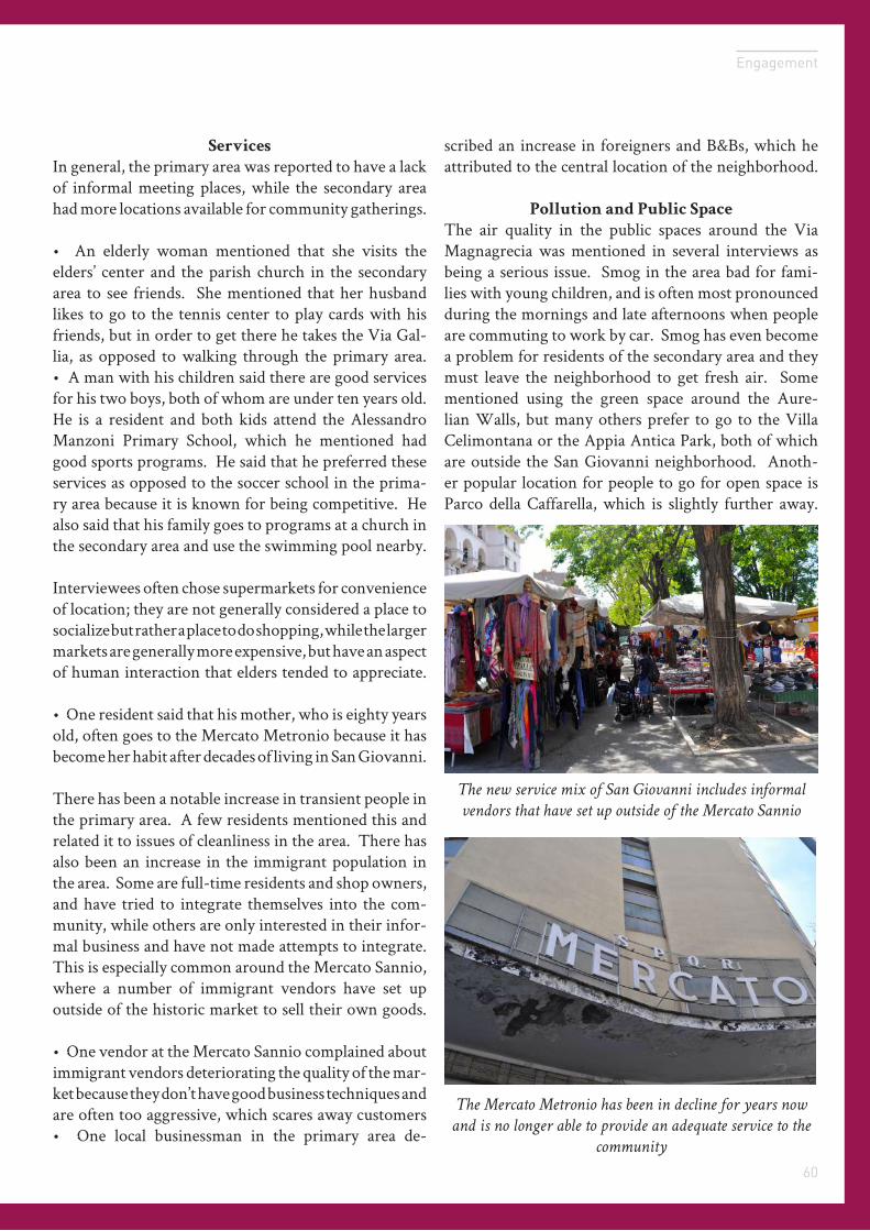
There has been a notable increase in transient people in the primary area. A few residents mentioned this and related it to issues of cleanliness in the area. There has also been an increase in the immigrant population in the area. Some are full-time residents and shop owners, and have tried to integrate themselves into the com-munity, while others are only interested in their infor-mal business and have not made attempts to integrate. This is especially common around the Mercato Sannio, where a number of immigrant vendors have set up outside of the historic market to sell their own goods.
• One vendor at the Mercato Sannio complained about immigrant vendors deteriorating the quality of the mar-ket because they don’t have good business techniques and are often too aggressive, which scares away customers• One local businessman in the primary area de-
scribed an increase in foreigners and B&Bs, which he attributed to the central location of the neighborhood.
Pollution and Public Space
The air quality in the public spaces around the Via Magnagrecia was mentioned in several interviews as being a serious issue. Smog in the area bad for fami-lies with young children, and is often most pronounced during the mornings and late afternoons when people are commuting to work by car. Smog has even become a problem for residents of the secondary area and they must leave the neighborhood to get fresh air. Some mentioned using the green space around the Aure-lian Walls, but many others prefer to go to the Villa Celimontana or the Appia Antica Park, both of which are outside the San Giovanni neighborhood. Anoth-er popular location for people to go for open space is Parco della Caffarella, which is slightly further away.
The new service mix of San Giovanni includes informal
vendors that have set up outside of the Mercato Sannio
The Mercato Metronio has been in decline for years now
and is no longer able to provide an adequate service to the
community
Conclusion06
Rome Workshop
Key Takeaways
Image SubjectLargo Pannonia
Raphael Laude
57
Rome Workshop
Summary
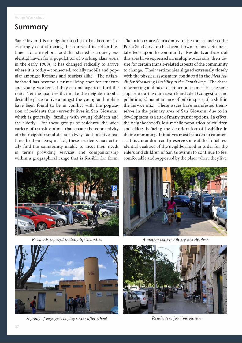
San Giovanni is a neighborhood that has become in-creasingly central during the course of its urban life-time. For a neighborhood that started as a quiet, res-idential haven for a population of working class users in the early 1900s, it has changed radically to arrive where it is today – connected, socially mobile and pop-ular amongst Romans and tourists alike. The neigh-borhood has become a prime living spot for students and young workers, if they can manage to afford the rent. Yet the qualities that make the neighborhood a desirable place to live amongst the young and mobile have been found to be in conflict with the popula-tion of residents that currently lives in San Giovanni, which is generally families with young children and the elderly. For these groups of residents, the wide variety of transit options that create the connectivity of the neighborhood do not always add positive fea-tures to their lives; in fact, these residents may actu-ally find the community unable to meet their needs in terms providing services and companionship within a geographical range that is feasible for them.
The primary area’s proximity to the transit node at the Porta San Giovanni has been shown to have detrimen-tal effects upon the community. Residents and users of this area have expressed on multiple occasions, their de-sire for certain transit-related aspects of the community to change. Their testimonies aligned extremely closely with the physical assessment conducted in the Field Au-
dit for Measuring Livability at the Transit Stop. The three reoccurring and most detrimental themes that became apparent during our research include 1) congestion and pollution, 2) maintainance of public space, 3) a shift in the service mix. These issues have manifested them-selves in the primary area of San Giovanni due to its development as a site of many transit options. In effect, the neighborhood’s less mobile population of children and elders is facing the deterioration of livability in their community. Initiatives must be taken to counter-act this conundrum and preserve some of the initial res-idential qualities of the neighborhood in order for the elders and children of San Giovanni to continue to feel comfortable and supported by the place where they live.
Residents engaged in daily-life activities
A group of boys goes to play soccer after school
A mother walks with her two children
Residents enjoy time outside
58
Conclusion
Policy Recommendations
In order to mitigate negative consequenc-es of transit node proximity and improve livability in the primary area for children and elders, we propose several policy measures to address the following three challenges: 1) congestion and pollution, 2) mainte-
nance of public spaces, 3) a shift in service mix.
The suggestions below endeavor to be holistic and ap-plicable to different contexts - that is, useful for public and private actors at all levels and in diverse contexts.
1
Parking, Bus Lanes, Safer Crosswalks, Green Initiatives
Traffic congestion and pollution are the most wide-spread problems of the area, and efforts to support carbon-producing automobile usage through policy are subject to significant political and public relations’ considerations. First with regards to parking issues, governments may consider direct public investment in a limited capacity to alleviate shortages, carefully mon-itoring the market so as not to incentivize greater auto-mobile usage. For governments with tight budgets such as in Italy, tax incentives for privately-run parking ga-rages to improve their service quality are a possibility.
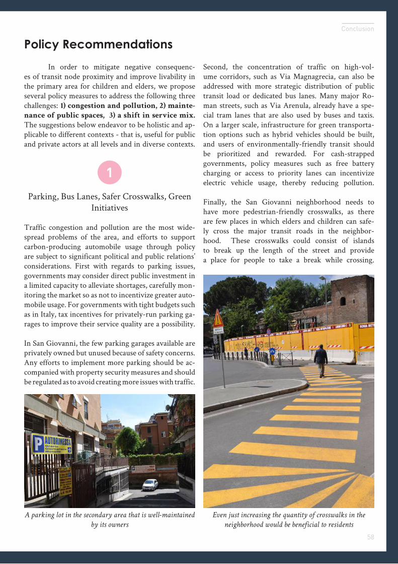
In San Giovanni, the few parking garages available are privately owned but unused because of safety concerns. Any efforts to implement more parking should be ac-companied with property security measures and should be regulated as to avoid creating more issues with traffic.
A parking lot in the secondary area that is well-maintained
by its owners
Second, the concentration of traffic on high-vol-ume corridors, such as Via Magnagrecia, can also be addressed with more strategic distribution of public transit load or dedicated bus lanes. Many major Ro-man streets, such as Via Arenula, already have a spe-cial tram lanes that are also used by buses and taxis. On a larger scale, infrastructure for green transporta-tion options such as hybrid vehicles should be built, and users of environmentally-friendly transit should be prioritized and rewarded. For cash-strapped governments, policy measures such as free battery charging or access to priority lanes can incentivize electric vehicle usage, thereby reducing pollution.
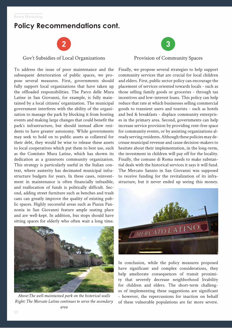
Finally, the San Giovanni neighborhood needs to have more pedestrian-friendly crosswalks, as there are few places in which elders and children can safe-ly cross the major transit roads in the neighbor-hood. These crosswalks could consist of islands to break up the length of the street and provide a place for people to take a break while crossing.
Even just increasing the quantity of crosswalks in the
neighborhood would be beneficial to residents
59
Rome Workshop
Policy Recommendations cont.
2 3
Gov’t Subsidies of Local Organizations
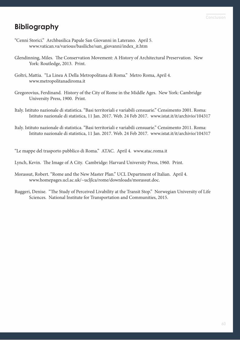
To address the issue of poor maintenance and the subsequent deterioration of public spaces, we pro-pose several measures. First, governments should fully support local organizations that have taken up the offloaded responsibilities. The Parco delle Mura Latine in San Giovanni, for example, is fully main-tained by a local citizens’ organization. The municipal government interferes with the ability of the organi-zation to manage the park by blocking it from hosting events and making large changes that could benefit the park’s infrastructure, but should instead allow resi-dents to have greater autonomy. While governments may seek to hold on to public assets as collateral for their debt, they would be wise to release these assets to local cooperatives which put them to best use, such as the Comitato Mura Latine, which has shown its dedication as a grassroots community organization. This strategy is particularly useful in the Italian con-text, where austerity has decimated municipal infra-structure budgets for years. In these cases, reinvest-ment in maintenance is often financially infeasible, and reallocation of funds is politically difficult. Sec-ond, adding street furniture such as benches and trash cans can greatly improve the quality of existing pub-lic spaces. Highly successful areas such as Piazza Pan-nonia in San Giovanni feature ample seating place and are well-kept. In addition, bus stops should have sitting spaces for elderly who often wait a long time.
Above:The well-maintained park on the historical walls
Right: The Mercato Latino continues to serve the secondary
area
Provision of Community Spaces
Finally, we propose several strategies to help support community services that are crucial for local children and elders. First, public sector policy can encourage the placement of services oriented towards locals - such as those selling family goods or groceries - through tax incentives and low-interest loans. This policy can help reduce that rate at which businesses selling commercial goods to transient users and tourists - such as hotels and bed & breakfasts - displace community enterpris-es in the primary area. Second, governments can help increase service provision by providing rent-free space for community events, or by assisting organizations al-ready serving residents. Although these policies may de-crease municipal revenue and cause decision-makers to hesitate about their implementation, in the long-term, the investment in children will pay off for the locality.Finally, the comune di Roma needs to make substan-tial deals with the historical services it says it will fund. The Mercato Sannio in San Giovanni was supposed to receive funding for the revitalization of its infra-structure, but it never ended up seeing this money.
In conclusion, while the policy measures proposed have significant and complex considerations, they help ameliorate consequences of transit proximi-ty that severely decrease neighborhood livability for children and elders. The short-term challeng-es of implementing these suggestions are significant - however, the repercussions for inaction on behalf of these vulnerable populations are far more severe.
60
Conclusion
Bibliography
“Cenni Storici.” Archbasilica Papale San Giovanni in Laterano. April 5. www.vatican.va/various/basiliche/san_giovanni/index_it.htm Glendinning, Miles. The Conservation Movement: A History of Architectural Preservation. New York: Routledge, 2013. Print. Goltri, Mattia. “La Linea A Della Metropolitana di Roma.” Metro Roma, April 4. www.metropolitanadiroma.it Gregorovius, Ferdinand. History of the City of Rome in the Middle Ages. New York: Cambridge University Press, 1900. Print.
Italy. Istituto nazionale di statistica. “Basi territoriali e variabili censuarie.” Censimento 2001. Roma: Istituto nazionale di statistica, 11 Jan. 2017. Web. 24 Feb 2017. www.istat.it/it/archivio/104317
Italy. Istituto nazionale di statistica. “Basi territoriali e variabili censuarie.” Censimento 2011. Roma: Istituto nazionale di statistica, 11 Jan. 2017. Web. 24 Feb 2017. www.istat.it/it/archivio/104317
“Le mappe del trasporto pubblico di Roma.” ATAC. April 4. www.atac.roma.it Lynch, Kevin. The Image of A City. Cambridge: Harvard University Press, 1960. Print.
Morassut, Robert. “Rome and the New Master Plan.” UCL Department of Italian. April 4. www.homepages.ucl.ac.uk/~ucljlca/rome/downloads/morassut.doc.
Ruggeri, Denise. “The Study of Perceived Livability at the Transit Stop.” Norwegian University of Life Sciences. National Institute for Transportation and Communities, 2015.
Appendix07
Statistical TablesLivability Audit DataCognitive MapsBibliography
Rome Workshop
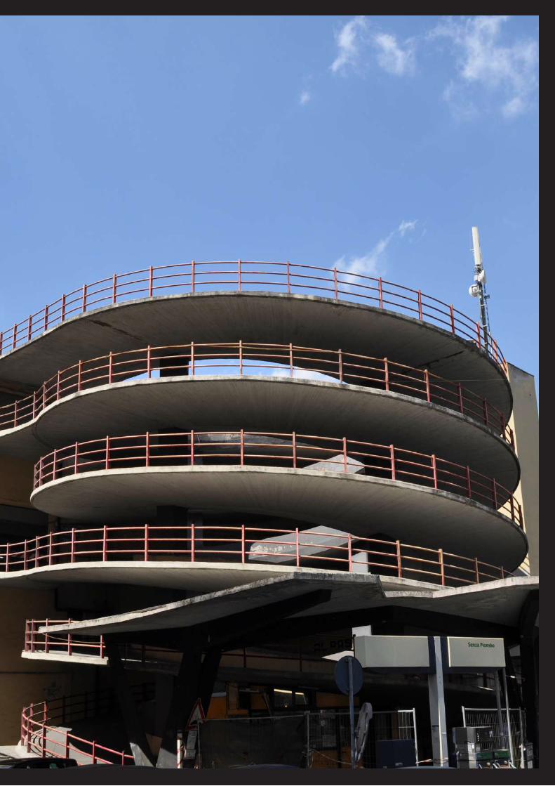
Image Subject
Image Credit
DSC_0878.JPG
69
Rome Workshop
Statistical Table S1
70
Appendix
Statistical Table S2
71
Rome Workshop
Primary Area Livability Audit Results
PRIMARY AREA MercatoPorta San Giovanni
Three-way Intersection
Scuola Media
Giovanni Pascoli
Piazza Ipponio
Imageability average
Q 1 1 0 2 0 1 0.8Q 2 0 0 0 0 0 0Q 3 2 5 2 5 2 3.2Q 4 1 1 1 2 3 1.6Q 5 2 6 3 1 2 2.8Q 6 4 4 0 1 9 3.6Q 7 1 1 6 10 10 5.6Q 8 5 8 7 5 2 5.4Q 9 6 3 1 0 0 2Q 10 0 0 0 1 0 0.2Transparency average
Q 11 0 -1 0 -1 0 -0.4Q 12 1 2 1 1 1 1.2Q 13 4 4 4 3 2 3.4Q 14 2 6 3 2 2 3Enclosure average
Q 15 1 3 1 1 1 1.4Q 16 1 1 1 1 1 1Q 17 1 0 2 0 0 0.6Q 18 3 3 2 3 3 2.8Human Experience average
Q 19 1 1 3 1 4 2Q 20 8 8 5 5 3 5.8Q 21 18 25 12 13 14 16.4Q 22 1 2 0 0 0 0.6Vitality average
Q 23 -1 -1 0 -1 -2 -1Q 24 3 1 3 1 1 1.8Q 25 4 4 2 6 4 4Connectivity average
Q 26 3 3 3 3 3 3Q 27 -3 -4 -3 -3 0 -2.6Q 28 0 6 0 1 1 1.6
72
Appendix
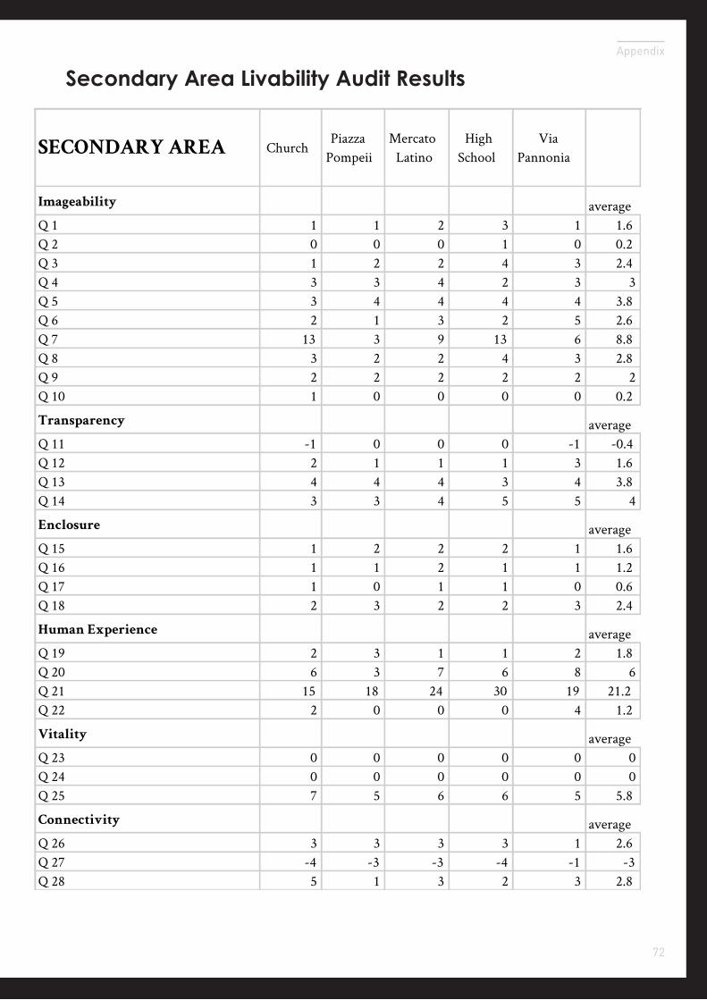
Secondary Area Livability Audit Results
SECONDARY AREA ChurchPiazza
PompeiiMercato
LatinoHigh
SchoolVia
Pannonia
Imageability averageQ 1 1 1 2 3 1 1.6Q 2 0 0 0 1 0 0.2Q 3 1 2 2 4 3 2.4Q 4 3 3 4 2 3 3Q 5 3 4 4 4 4 3.8Q 6 2 1 3 2 5 2.6Q 7 13 3 9 13 6 8.8Q 8 3 2 2 4 3 2.8Q 9 2 2 2 2 2 2Q 10 1 0 0 0 0 0.2
Transparency averageQ 11 -1 0 0 0 -1 -0.4Q 12 2 1 1 1 3 1.6Q 13 4 4 4 3 4 3.8Q 14 3 3 4 5 5 4
Enclosure averageQ 15 1 2 2 2 1 1.6Q 16 1 1 2 1 1 1.2Q 17 1 0 1 1 0 0.6Q 18 2 3 2 2 3 2.4
Human Experience averageQ 19 2 3 1 1 2 1.8Q 20 6 3 7 6 8 6Q 21 15 18 24 30 19 21.2Q 22 2 0 0 0 4 1.2
Vitality averageQ 23 0 0 0 0 0 0Q 24 0 0 0 0 0 0Q 25 7 5 6 6 5 5.8
Connectivity averageQ 26 3 3 3 3 1 2.6Q 27 -4 -3 -3 -4 -1 -3Q 28 5 1 3 2 3 2.8
73
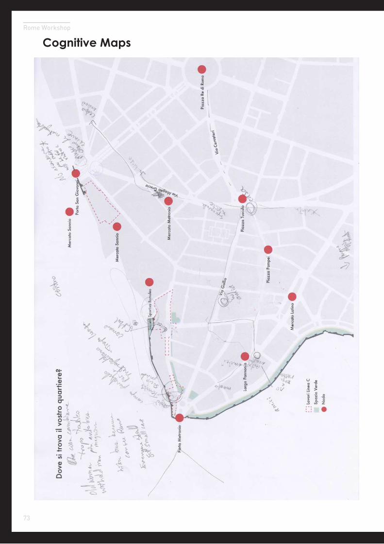
Rome Workshop
Cognitive Maps
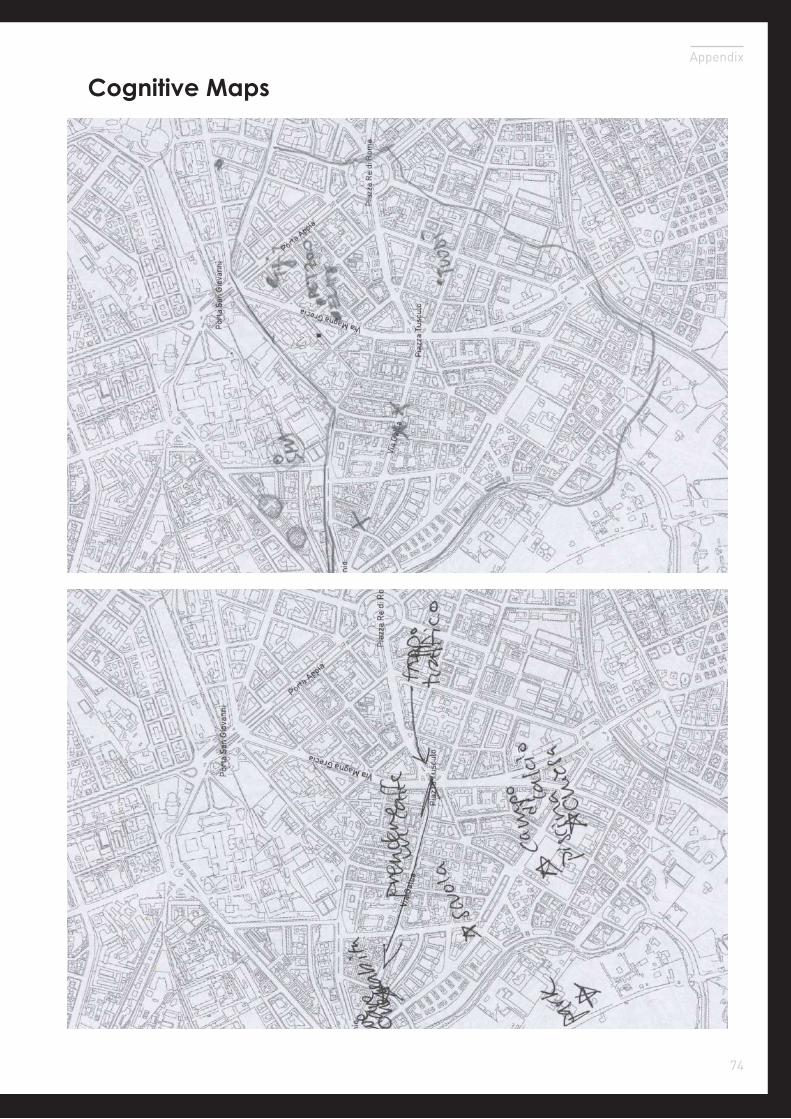
74
Appendix
Cognitive Maps
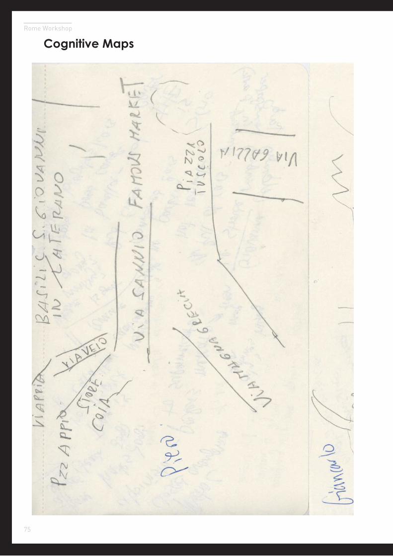
75
Rome Workshop
Cognitive Maps
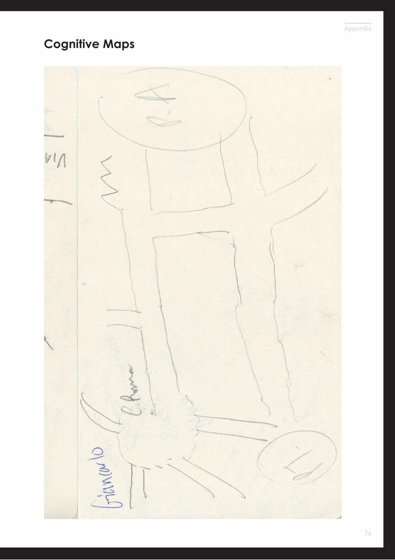
76
Appendix
Cognitive Maps