Embed Size (px)
Citation preview

i
FINAL REPORT
March 2001
i
The Underlying Causes and Impacts of Fires in South-east Asia
Final Report
Prepared by
Grahame Applegate1, Unna Chokkalingam1 and Suyanto2,
1Center for International Forestry Research (CIFOR) 2 International Centre for Research in Agroforestry (ICRAF)
Map designs: Yayat Ruchiat, Rizki Pandu Permana, and Danan Prasetyo Hadi
Corresponding author and contact address: Grahame Applegate
Center for International Forest Research (CIFOR) PO Box 6596 JKPWB
10065 Jakarta Indonesia
March 2001

i
Table of Contents Page No.
Foreword............................................................................................................................................................. i
Acknowledgements............................................................................................................................................ ii
Abbreviations and Terms..................................................................................................................................iii
Summary ........................................................................................................................................................... iv
1. INTRODUCTION........................................................................................................................................ 1
2. METHODOLOGY....................................................................................................................................... 2 2.1 Location .................................................................................................................................................. 2 2.2 Social Surveys ........................................................................................................................................ 3 2.3 Remote Sensing and Geographic Information System (GIS) ................................................................. 3
2.3.1 Site-specific level ..................................................................................................................... 3 2.3.2 TM or satellite image level ....................................................................................................... 3 2.3.3 Island-wide analysis ................................................................................................................. 3
2.4 Linking Remote Sensing and Social Science Information...................................................................... 4
3. VEGETATION INDICES ANALYSIS....................................................................................................... 5 3.1 Results 5 3.2 Recommendations................................................................................................................................... 5
4. HOT SPOT ANALYSIS .............................................................................................................................. 6 4.1 Result and Discussion............................................................................................................................. 6
5. SITE ANALYSIS......................................................................................................................................... 7 5.1 Sekincau - Lampung Province................................................................................................................ 7
5.1.1 Fire in relation to land cover changes....................................................................................... 7 5.1.2 Social survey and participatory mapping.................................................................................. 8 5.1.3 Underlying causes of fires ........................................................................................................ 9 5.1.4 Policy issues ............................................................................................................................. 9
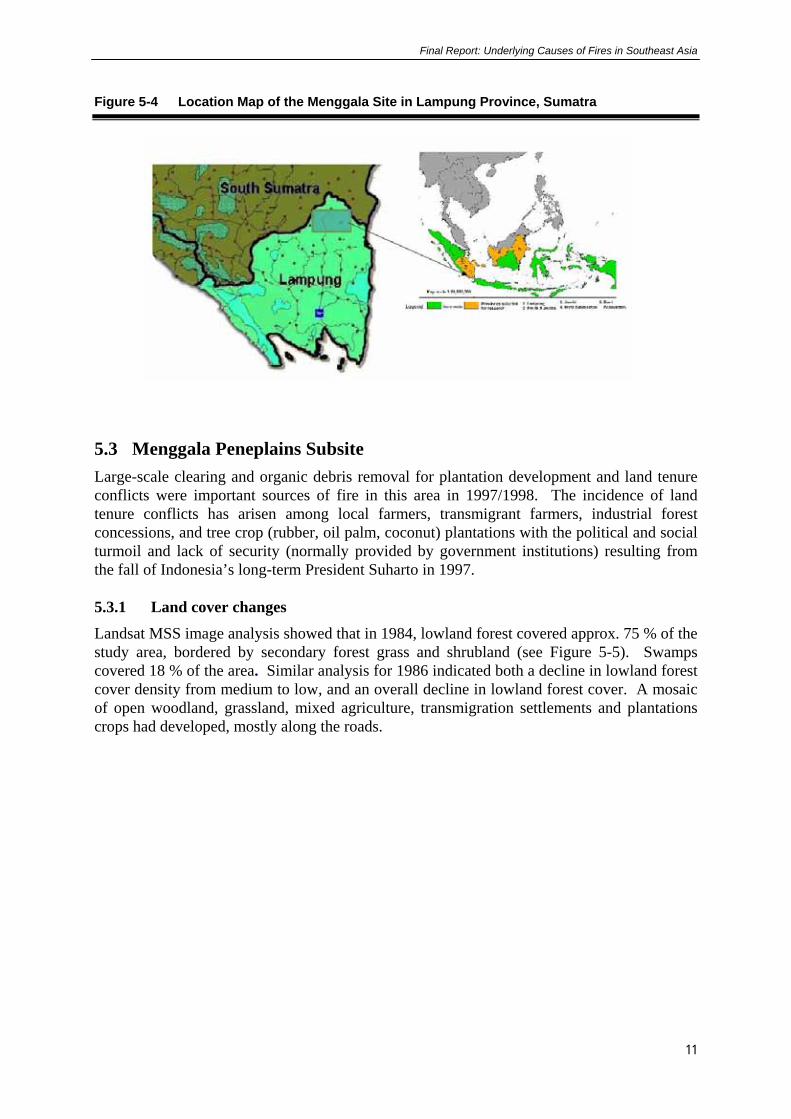
5.2 Menggala - Lampung Province ............................................................................................................ 10 5.3 Menggala Peneplains Subsite ............................................................................................................... 11
5.3.1 Land cover changes ................................................................................................................ 11 5.3.2 Social survey and participatory mapping................................................................................ 12 5.3.3 Underlying causes of fires ...................................................................................................... 13 5.3.4 Policy issues ........................................................................................................................... 14
5.4 Menggala Swampland Subsite.............................................................................................................. 14 5.4.1 Land cover changes ................................................................................................................ 14 5.4.2 Social survey and participatory mapping................................................................................ 15 5.4.3 Underlying causes of fires ...................................................................................................... 15 5.4.4 Policy issues ........................................................................................................................... 15
5.5 Musi Banyu Asin - South Sumatra Province ........................................................................................ 16 5.5.1 Location.................................................................................................................................. 16 5.5.2 Land cover changes ................................................................................................................ 17 5.5.3 Social survey and participatory mapping................................................................................ 18 5.5.4 Underlying causes of fires ...................................................................................................... 18 5.5.5 Policy issues ........................................................................................................................... 19
5.6 Tanah Tumbuh - Jambi Province.......................................................................................................... 19 5.6.1 Location.................................................................................................................................. 19 5.6.2 Land cover/land use changes .................................................................................................. 20 5.6.3 Social survey and participatory mapping................................................................................ 20

ii
5.6.4 Underlying causes of fires ...................................................................................................... 21 5.6.5 Policy issues ........................................................................................................................... 21
5.7 Sanggau - West Kalimantan ................................................................................................................. 22 5.7.1 Land cover changes ................................................................................................................ 23 5.7.2 Social survey and participatory mapping................................................................................ 23 5.7.3 Underlying causes of fires ...................................................................................................... 24 5.7.4 Policy issues ........................................................................................................................... 25
5.8 Tumbang Titi - West Kalimantan ......................................................................................................... 25 5.8.1 Land cover changes ................................................................................................................ 26 5.8.2 Social survey and participatory mapping................................................................................ 26 5.8.3 Underlying causes of fires ...................................................................................................... 27 5.8.4 Policy issues ........................................................................................................................... 27
5.9 Danau Sentarum - West Kalimantan .................................................................................................... 28 5.9.1 Fire and land cover changes ................................................................................................... 28 5.9.2 Social survey and participatory mapping................................................................................ 29 5.9.3 Underlying causes of fires ...................................................................................................... 30 5.9.4 Policy issues ........................................................................................................................... 31
5.10 Long Segar - East Kalimantan Province ........................................................................................ 32 5.10.1 Land cover changes.............................................................................................................. 32 5.10.2 Social survey and participatory mapping ............................................................................. 33 5.10.3 Underlying causes of fire ..................................................................................................... 34 5.10.4 Policy issues......................................................................................................................... 34
6. SYNTHESIS OF UNDERLYING CAUSES OF FIRE ............................................................................. 35 6.1 Direct Causes ........................................................................................................................................ 36 6.2 Underlying Causes of Fire .................................................................................................................... 37
7. POLICY ISSUES AND IMPLICATIONS ................................................................................................ 45 7.1 Policy Issues and Implications to Reduce Fires as Tools in Land Clearing ......................................... 45 7.2 Policy Issues and Implications on Land Use Allocation and Land Tenure .......................................... 46 7.3 Policy Issues and Implications to Reduce the Impact of Shift in Demographic
Characteristics....................................................................................................................................... 46 7.4 Policy Issues and Implications of Reducing Forest Degrading Practices ............................................. 47 7.5 Policy Issues and Implications on Economic Incentives/Disincentives ............................................... 47 7.6 Policy Issues and Implications on Institutional Capacity ..................................................................... 48
8. References .................................................................................................................................................. 52
Appendices....................................................................................................................................................... 53 FIGURES Figure 2-1 Location Map of Study Sites in Indonesia .......................................................................... 2

iii
Figure 5-1 Location Map of the Sekincau Site in Lampung Province, Sumatra .................................. 7 Figure 5-2 Land Cover Classification 1985, 1994 and 1997 Derived from Satellite
Imagery ............................................................................................................................... 8 Figure 5-3 Coffee Production Areas within the Boundary of the Bukit Barisan National
Park ................................................................................................................................... 10 Figure 5-4 Location Map of the Menggala Site in Lampung Province, Sumatra ............................... 11 Figure 5-5 Land Cover Changes Between 1984 and 1999 ................................................................. 12 Figure 5-6 Young Acacia Plantations Less Than 3 Years Old are Often Killed by Fire.................... 13 Figure 5-7 Communities Involved in Sonor and the Harvesting of gelam (Melaleuca
cajuputi ) ........................................................................................................................... 15 Figure 5-8 Location of Musi Banyu Asin Site, South Sumatra Province ........................................... 17 Figure 5-9 Land Cover Changes from 1986-1998 in the Musi Banyu Asin Site ............................... 18 Figure 5-10 Location of Tanah Tumbuh Site, Jambi Province............................................................. 20 Figure 5-11 Burnt out Office Belonging to a Plantation Company ...................................................... 21 Figure 5-12 Location Map of the Sanggau Site in West Kalimantan ................................................... 22 Figure 5-13 Felling Company Timber Plantation Trees in Preparation for Swidden ........................... 24 Figure 5-14 Location Map of Tumbang Titi Site in West Kalimantan Province.................................. 26 Figure 5-15 Imperata Grasslands Near Mahawa Village ..................................................................... 27 Figure 5-16 Location Map of Danau Sentarum Site in West Kalimantan Province............................. 28 Figure 5-17 Land Cover Changes in Danau Sentarum from 1973- 1997 ............................................. 29 Figure 5-18 Flooded Burnt Tall Swamp Forest in Danau Sentarum .................................................... 30 Figure 5-19 Location Map of the Long Segar Site in East Kalimantan Province ................................ 32 Figure 5-20 Fire in Logged Over Dipterocarp Forests ......................................................................... 33 TABLES Table 6-1 Summary of Underlying Causes of Fire Based on the Eight Site in Sumatra and
Kalimantan........................................................................................................................ 40 Table 6-2 Relative Importance of the Direct and Underlying Causes of Fire in Indonesia .............. 44 Table 7-1 Policy Issues and Implications of the Underlying Causes of Fire..................................... 49

i
Foreword
The fires in 1997/98 which occurred throughout Indonesia were not something new as they have occurred numerous times throughout the archipelago in the recent past. However, there have been a number of claims and assumptions made on the underlying causes and causal histories of these fires. There have been some exaggerated claims made as to the causes and some unsubstantiated claims based on specific ignition events. The research undertaken aims to address some of these issues by analysing the fires and their range of severity in relation to the causal histories based on a number of sites with different characteristics, policies, land use practices to determine the underlying causes of fire.
The research on the underlying causes of fire in Indonesia focused on eight sites, four in Sumatra and four in Kalimantan. The selected sites with different characteristics provided important diversity at the site specific landscape scale to analyse the problem.
This report presents the findings of the team, based on a partnership involving CIFOR, ICRAF, the US Forest Service and the Provincial authorities in Sumatra and Kalimantan to undertake an analysis of the Underlying Causes and Impacts of Fires in Indonesia.
Field work for the analysis was carried out over the period November 1998 - December 2000 .
The Final Report of the Underlying Causes and Impacts of Fires in South-East Asia and its main findings, conclusions and recommendations from the analysis of the underlying causes identify important policy issues which need to be pursued to enhance prevention and suppression of unwanted fires in Indonesia.
ii
Acknowledgements
The CIFOR/ ICRAF/USFS team which consisted of Grahame Applegate, Team Co-ordinator, Suyanto, Economist; Tom Tomich, Economist; Rona Dennis, GIS/Remote Sensing Specialist; Fred Stolle, Remote Sensing Specialist; Paul Maus, Remote Sensing Specialist; Henry Lawkowski, Remote Sensing Specialist; Yayat Ruchiat, Field Research Assistant; Iwan Kurniawan, Remote Sensing Analyst; Andi Erman, Field Assistant; Judith Mayer, Sociologist; Carol Colfer, Sociologist; Ann Casson, Sociologist.
The team involved in the study acknowledges the support received from US International Agency for Development (USAID) and the US Forest Service, CIFOR and ICRAF to undertake the study. The team would also like to express thanks and acknowledge the contributions made by the following organisations and persons who assisted in implementing the study and ensuring its successful completion:
Government of Indonesia: Officials in the Provinces and Districts in which the sites are located; Staff from the Ministry of Forestry and Estate Crops (MOFEC) Directorate of Forest Fire, Bogor,
Government of the United States of America: Mr Gary Mann and Dr Mary Melynk from the US Forest Service in Washington for guidance and advice.
European Union: Staff from the various European Union/MOFEC fire-related projects in Indonesia for advice on site selection, help with field logistics and insights regarding fire in their specific locations. The EU Forest Fire Prevention and Control Project in South Sumatra also provided some hot-spot data.
The JICA/PKA Forest Fire Prevention and Management Project in Bogor; and the Joint Research Centre of the European Commission in Ispra, Italy for providing some hot-spot data.
Tropical Rain Forest Information Center, Basic Science and Remote Sensing Initiative, Michigan State University for providing some of the imagery used in this study.
Christoph Feldkötter for providing valuable additions to the GIS analysis software.
Yayasan Karya Sosial Pancur Kasih (PPSDAK) and DIAN TAMA. for their collaboration with field data collection and analysis in West Kalimantan.
Rika D. Damanik, a student at Bogor Agricultural University, and Jasnari, ICRAF’s field assistant at Muara Bungo, Jambi for field work assistance on the Tanah Tumbuh site, Jambi.
Erlina Rusli, Fauzia and Joko from a local NGO for field work assistance on the Sekincau site.
Mufti Mubarak, a student at Bogor Agricultural University and Ade Herdiana, a student at Siliwangi University for field work assistance on the Menggala site.
Local communities in the different study sites for their patient participation in the interviews.

iii
Abbreviations and Terms
Adat rights Traditional ownership or use rights recognised by local law
ADB Asian Development Bank
AVHRR Advanced Very High Resolution Radiometer
CIFOR Center International Forestry Research
GIS Geographic Information System
ha hectare
ICRAF International Centre for Research in Agroforestry
Km Kilometers
Landsat MSS Landsat Multispectural Scanner. An imaging system found on the first five Landsat satellites. The system collects multispectral data in four non-thermal radiation ands with a spatial resolution of 79 x 79 m
m meter
m a.s.l. meter above sea level
MoFEC Ministry of Forestry and Estate Crops
NOAA National Oceanic and Atmospheric Administration, USA
RSTRP Rencana Struktur Tata Ruang Propinsi
(Provincial Structural Spatial Plan)
SAR Synthetic Aperture Radar
SFM Sustainable Forest Management
SFT Silvicultural Forest Types
SPOT XS Système Probatoire pour l'Observation de la Terre. A French commericial satellite program designed to collect high resolution imagery (resolution of 20 x 20 m)
Stakeholders People or groups of people interested or responsible for forest management. Includes landowners, community, industry and government organisations
USFS United States Forest Service

iv
Summary
Large-scale fires and associated smoke is an increasing problem in Indonesia and surrounding countries as evidenced by large scale burning in 1982/1983, 1987, 1991, 1994, and 1997/1998. These fires devastated large areas of forest and caused significant economic losses, both in Indonesia where most fires occurred and in neighboring countries. The major causes of these fires are, however, still unclear. Many have blamed small-scale farmers and large-scale estates for causing fires, suggesting that these actors deliberately set fire to forests to open up land for plantations or agriculture. In 1998, the Center for International Forestry Research (CIFOR), the International Centre for Research in Agroforestry (ICRAF), and the United States Forest Service (USFS) commenced a multi-disciplinary study into the underlying causes and impacts of forest and forest land fires in Indonesia. In order to assess the relative roles of the different factors influencing the creation of fire-prone and fire-resistant landscapes, eight study sites with different historical land use patterns were chosen across Sumatra and Kalimantan. A number of common land use situations were studied including large-scale plantations, transmigration projects, small-holder plantations, logging activities in natural forests, and agriculture. The sites also included some areas with peat soils, the burning of which contributed substantially to smoke and haze during the 1997/98 fires. The sites formed the basis for understanding the extent to which the causes of fires are influenced by land use policies and practices from the village level through to the central government. Combining spatial analysis with social science research provided answers to these questions. Satellite imagery along with field investigations provided information on the location, extent, and the type of land cover burned. However, only through extensive interviews with local people combined with on-the-ground participatory mapping, could information be derived regarding who was responsible for the fires and what were the underlying reasons for them. The study found that there were a number of direct causes of fire on any one site. The study identified four direct causes as follows: • Fire being used to assist with land clearing,
• Fire used as a weapon in land tenure or land use disputes,
• Accidental or escaped fires,
• Fire connected with resource extraction.
The main underlying causes of the fires are as follows: • Land use allocation; involving inappropriate and /or uncoordinated land use allocation. • Land tenure issues; relating to the fact that informal land tenure security promotes site
occupation and forest conversion; increased “private” land rights with tree planting on communal forest land according to customary law; no incentive for local communities to control unwanted fires on land for which they have no responsibility, or receive benefit; overlapping land use claims between local communities, migrants, large companies, and forest managers and lack of a transparent legal system to address land claims and traditional communal rights

v
• Shift in demographic characteristics has resulted from large scale in migration; lack of commitments to new location and careless use of fire; inexperience with use of fire in new environments and different resource use patterns (fire) by different ethnic groups.
• Forest degrading practices have resulted from inappropriate timber harvesting practices;
large scale drainage systems in swamps that lower the water table, dries the forest and provide increased access and repeated fires due to increased fire proneness of previously burned vegetation
Financial incentives/disincentives which created profitability of alternate land use (e.g. coffee, small holder rubber, oil palm, rubber, timber) and perverse development processes and mechanisms. Inadequate institutional capacity resulting from lack of institutional capability and capacity; inadequate resources and political will to monitor and deal with encroachment and other illegal activities in forest areas; inadequate forest and fire management plans, and facilities to prevent and suppress accidental or escaped fires in plantations and natural forests. Based on the identification of both direct and indirect causes of fire in this research on the underlying causes of fire, two crucial policy issues and implications were highlighted. These are the use of fire as a tool in land clearing and land use allocation /land tenure problem. In addition policies to reduce the impact of the shift in demographic characteristics in a number of fire prone provinces, to reduce forest degrading practices relating to timber harvesting and land preparation, to build economic incentives/disincentives and to strength institutional capacity by training and improved access to resources also need to be addressed. Most of these policy issues will need to be assessed with the fact that decentralisation of the decision making power is of the central government now being divested to the provincial and district authorities.

Final Report: Underlying Causes of Fires in Southeast Asia
1
1. INTRODUCTION Large-scale fires and associated smoke are an increasing problem in Indonesia and surrounding countries. For instance, major fires occurring in the El Niño years 1982/1983, 1987, 1991, 1994, and 1997/1998 (Dennis, 1999) devastated large areas of forest and caused significant economic losses, both in Indonesia where most fires occurred and in neighboring countries. The area burned in the 1997/98 fires is estimated at 9.7 million hectares of forest and non-forest land in Indonesia, with some 75 million people affected by smoke, haze, and the fires themselves. Impacts included damage to health, loss of life, property and reduced livelihood options. The economic costs were estimated to exceed 9 billion USD with carbon emissions high enough to elevate Indonesia to one of the largest polluters in the world (ADB 1999; Barber and Schweithelm, 2000). The major causes of these fires are, however, still unclear. Many have blamed small-scale farmers and large-scale estates for causing fires, suggesting that these actors deliberately set fires to forest to open up land for plantations or agriculture. In 1994, the Indonesian government pointed at slash-and-burn activities by smallholders as the major cause of fire, and they estimated that these people accounted for more than 85 % of the 5,000,000 ha burned (Jakarta Post, 7 October 1994). Environmental NGOs, however, blamed activities by forest concessionaires and plantation owners as the major causes of fires (Jakarta Post, 3 October 1994). With data available from fire hot-spot information and satellite imagery, all institutions, including government agencies, infer that large-scale land clearing for plantations of fast growing trees for pulpwood and oil palm were the major causes of fire in those years in 1997 and 1998. Yet, fires occurred at multiple scales and for many reasons, and impacts on local communities and forest had a variety of complex causes. In this report, the Center for International Forestry Research (CIFOR), the International Centre for Research in Agroforestry (ICRAF), and the United States Forest Service (USFS) present the results of multi-disciplinary research into the underlying causes and impacts of forest and forest land fires in Indonesia. The study was designed to build on and add to information and insights gained from previous investigations into the fires in various locations in Indonesia. The aim was to answer questions about the reasons (why), nature (what), perpetrators (who), and locations (where) associated with the fires. Tomich et al. (1998) developed the following hypotheses regarding the reasons for fire ignition and spread. According to the authors, there are three sources of fires: fires used as a tool to clear land; fires that accidentally go out of control; and fires used as a weapon in social conflict. In order to assess the relative roles of the different factors influencing the creation of fire-prone and fire-resistant landscapes, eight study sites with different historical land use patterns were chosen across Sumatra and Kalimantan. These sites formed the basis for understanding the extent to which the causes of fires are influenced by land use policies and practices from the village level through to the central government. The sites were studied in detail by linking spatial and temporal data with socio-economic information at the landscape level, to provide a sound basis for diagnosing the causes of vegetation fires and formation of fire-prone and fire-resistant landscapes. Based on the analysis of underlying causes, possible policy implications are highlighted.

Final Report: Underlying Causes of Fires in Southeast Asia
2
2. METHODOLOGY This study combines remote sensing/geographic information systems (GIS) with in-depth field investigations at the landscape level, to obtain a more complete picture of the fires in general, and the 1997 fires in particular. In connection with fires in Indonesia, there is inadequate detailed knowledge regarding how much area burned, the nature and location of areas burned, and by whom and why. Combining spatial analysis with social science research provided answers to these questions. Satellite imagery along with some field investigations provided information on the location, extent, and the type of land cover burned. However, only through extensive interviews with local people combined with on-the-ground participatory mapping, could information be derived regarding who was responsible for the fires and what were the underlying reasons for them. 2.1 Location Eight study sites spread over a number of different but common land use situations in Sumatra and Kalimantan (Figure 2-1) were identified from previous investigations. Common land use situations include development of large-scale plantations, transmigration projects, small-holder plantations, logging activities in natural forests, and agriculture among others. The sites also include some areas with peat soils, the burning of which contributed substantially to smoke and haze during the 1997/98 fires. Most of the 1997/98 fires in the western part of Indonesia occurred on Sumatra and Kalimantan. In 1994 and the 1980s as well as in earlier years, fire was also a major problem on these islands. These two islands are economically very important to Indonesia and the rate of deforestation and conversion to other land uses is very high. Estimates from MoFEC reveal that the rate of deforestation could be as high as 1.7 million ha/year.
Figure 2-1 Location Map of Study Sites in Indonesia

Final Report: Underlying Causes of Fires in Southeast Asia
3
2.2 Social Surveys Social surveys were conducted using rural appraisal techniques and participatory mapping to develop sketch maps of burnt areas at the landscape scale and identify conflict areas where customary land or resource use overlapped with official land designations in relation to fire incidents. Fire and land use history, land clearing customs and techniques, institutions, and people involved were also recorded. Representatives of all stakeholders on the study sites were interviewed. 2.3 Remote Sensing and Geographic Information System (GIS) Remote sensing and a GIS were used for gathering spatial information on planning boundaries, fire scars, forest concession areas, land use and land cover status and land cover change over time. This study applied three levels of spatial analysis: island-wide, TM-level, and site or landscape scale. 2.3.1 Site-specific level
Remote sensing and GIS were used to analyze the historic and current patterns of land cover and land use change over time as related to fire in each of the eight study sites/landscapes. Sets of high quality remotely sensed imagery were acquired for each of the study sites selected from among Landsat Thematic Mapper (TM), Multi Spectral Scanner (MSS), SPOT, and in one instance Synthetic Aperture Radar Coherence imagery. In general, these image sets covered 3-4 dates from the mid-1980s to the late 1990’s. The images were first geo-referenced to a known base map, spectrally enhanced and then classified for land cover, including burn scars relating to recently burned areas. Finally land cover change analyses were carried out over the years covered by the imagery. As a result, trajectories of change and cumulative area estimates of such change were determined, e.g. area of natural forest burned and converted into coffee gardens. 2.3.2 TM or satellite image level
Full scenes of imagery (185 km x 185 km) were mapped according to land cover categories for the different years available. These were the same images discussed in the detailed site level analysis (see 2.3.1). After classification, map overlay analysis techniques using a GIS were applied to determine 1) where land cover changes occurred between the dates of imagery and 2) what relationship these changes had to the recent burn scars. For example, what types of land cover existed in 1994 and 1985 for areas burned in 1997? Comparisons between the study site and surrounding areas within the extent of the satellite image are made using this level of information. Hypotheses were developed as to whether similar situations to the detailed study site existed. 2.3.3 Island-wide analysis
Hot-spots data from National Oceanic Atmospheric Administration (NOAA) AVHRR imagery collected on a daily basis since 1992 provide a fire history and fire frequency for the whole of Sumatra and Kalimantan. This information provides a means of comparing the study site with other study sites in Sumatra and Kalimantan, and with the province and island as a whole. The hot spot data was overlaid through GIS onto the TM-level land cover/land use classifications to identify the land cover/land use types burnt. Another part of this study involved broad scale static land use/cover data and NOAA Normalised Difference Vegetation Index (NDVI) imagery to detect land use cover changes on abroad scale. The NDVI was
Final Report: Underlying Causes of Fires in Southeast Asia
4
also correlated with hot spot occurrences to determine whether a change in NDVI was possible to detect or predict fire occurrence. Details of this study are found in Vegetation Indices and Fires in Sumatra and Kalimantan, Indonesia prepared by Fred Stolle as part of the Project. 2.4 Linking Remote Sensing and Social Science Information Apart from integrating land cover and land use maps, the GIS was used to integrate other data sets to assist with an understanding of the fire problem on the sites. Participatory mapping at the landscape level was carried out for each of the sites. The sketch maps produced as part of this process are an integral part of the site analysis process because they provide an important link between the social research and the spatial analysis. These maps form the basis for many of the discussions with local people at the sites. Details provided on the maps include; historic and current land tenure boundaries claimed by local people, conflict areas between land users, areas of fires, location of villages and other important physical features. These sketch maps were input to the GIS as digital maps where they were overlaid with the land cover, land use maps, and fire hot spots. Using the GIS, the size of the areas claimed by local people were determined, boundary overlaps with other land users were identified, such as companies, and precise estimates of different land cover types currently and historically were also determined. Estimates of how much land was burned and why, were roughly estimated from the sketch maps and interviews for each site at the landscape level. In summary, the importance of the contribution of linking the spatial analysis with social research cannot be overstated. Without the spatial analysis an understanding of the precise historic and current patterns on the sites in terms of fires could not be determined. What is lacking in much of the knowledge of fires in Indonesia, is how much area burned and the nature of areas burned by whom and why. Spatial analysis answers the first three questions and by linking social science with the spatial analysis it was possible to answer the remaining questions and extrapolate beyond the immediate research site boundaries to provide an estimate of the magnitude of the problems and impacts of the fires. One other important aspect of using GIS, which was highlighted in this study, is that GIS enabled the development of a product that is user-friendlier to decision makers than wordy reports, as much of the information is readily presented in pictorial format.
Final Report: Underlying Causes of Fires in Southeast Asia
5
3. VEGETATION INDICES ANALYSIS 3.1 Results This study was carried out to answer 3 questions 1) How are land cover changes distributed over Sumatra and Kalimantan over time, 2) What is the correlation of changes in land use/cover and hot-spots occurrences and 3) What do these correlation suggest about causal relationships. These separate issues have been analyzed with the aid of monthly hot-spots, land use/cover maps and broad scale monthly satellite derived vegetation data. Since land use/cover changes caused by man or biophysical conditions cannot be separated on this scale, the analyses uses the term “vegetation condition” to combine the two. The satellite data was averaged per island, province and land use, to analyse the overall changes. Normalizing the land use data per province eliminated influence of climate. The nature of the NDVI-8-km data (pixel size of 64 km2) does not allow comparison between dates per pixel. According to this study the changes in land use/cover is concentrated in the 3 central provinces of Sumatra (Jambi, Riau and West Sumatra), while the rate of change in Kalimantan changes per year per province. The changes in Sumatra have increased after 1996. In Kalimantan no de- or increase can be notices. Fires are determined in two provinces by the susceptibility of the vegetation to fire. In all other provinces other factors determined fire occurrence. The fire occurrence in Sumatra seems mainly depending on man planned land use/cover conversion while in Kalimantan the climatic and human factor are both important. In Sumatra fires so occur every year regardless of vegetation condition or climate, while the fire situation in Kalimantan is more variable depending on the climatic situation in a province. 3.2 Recommendations The analyses of distribution of land use/cover changes and the correlation between land use/cover and fire occurrences did not result in strong causal relations. One reason for this is that the data used for land use/cover change detection is 8 km data while the fire data is based on 1 km data. Another weakness is that the land use/cover maps available are often outdated and not very accurate. Spatial correlation of fires, land cover and land cover change on a pixel basis would be preferred. Therefore 1 km data from the NOAA or ATSR satellite should be used to interpret per year some general land cover types. Change detection maps and land cover maps can then be correlated to the same spatial resolution as the fire data.
Final Report: Underlying Causes of Fires in Southeast Asia
6
4. HOT SPOT ANALYSIS
4.1 Result and Discussion
In tests carried out in Indonesia, Along Track Scanning Radiometer (ATSR) data showed its usefulness in detecting fire. However it seems to detect less fire than the NOAA-AVHRR data. It was decided to use NOAA-AVHRR data for all analysis. There were more hot-spots detected in 1997 and 1998 than in 1992 and 1993. The number of fires increased from 1992 to 1998. However this increase cannot be fixed to a province or area, since the fires were widely distributed throughout the provinces in the year. 1997 was an exceptional year, with many more fires than in other years. However, East Kalimantan did not have more fires than usual. Therefore a real island wide fire season could not be distinguished. However in a ‘normal’ year, August/ September seems to be the time with the highest fire occurrence. The 1998 fire event happened almost exclusively in East Kalimantan. This can be compared to the 1998 extreme fire event in Sumatra. Since these provinces are separate, it is doubtful that the climatic conditions played a major role in the underlying causes of the fire. Both provinces though, have large land use changes going on. The cause of the fires cannot be determined from this data, but requires it to be used in conjunction with other remote sensing and social science research information. Fires occurred on small-holder land as well as on large-holder lands in an almost equal number as was the case in Sumatra. Here too, small and large-holders are responsible for fires. Again this data does not indicate who set the fire, it only determines where the fires were located. Most fires occurred in logging concessions and on small-holder lands. These areas also show the largest land use change. Although that seems logical for logging concessions converted to other land uses, the logic for the many fires on small-holder land is not well understood. Plantation areas have, as in Sumatra, the highest fire density. The overall land use change seems to occur in all land uses and is not concentrated in a small number as shown in Sumatra. Probably the land shortage is not an issue yet in Kalimantan and there is room to develop new lands. This would be in accordance with the data from East and West Kalimantan, where there is no shift in the number of fires from one land use to another. It is likely that the causes of fire in 1992 still existed in 1999. All land uses burn at the same time, except Alang that burns earlier than the other lands. In Kalimantan, the areas of Imperata grasslands are extensive. These grasslands dry out early and so can be distinguished from other land uses from the forest that they burn earlier. Fires are not randomly distributed over the island, but show strong clustering. Some areas show high hot-spot occurrences over several years indicating land use change. These areas occur in the southern part of Central Kalimantan. For the remainder, the fires cannot really be pin pointed, as every year other provinces experience fires. There seems to be no increase in fire in National Parks, except in East Kalimantan. In Central Kalimantan all hot-spot counts increased markedly in 1997, especially in timber plantations and Parks. In West Kalimantan, the number of hot-spots in different land uses from August 1992 and September 1997 is exactly the same. It seems that the same processes involving land use change was occurring in West Kalimantan from 1992 to 1999. The spread of hot-spots varies from year to year. In 1992, hot-spots were detected over the

Final Report: Underlying Causes of Fires in Southeast Asia
7
entire island, which in all other years show very strong clustering of hot spots. In Kalimantan, there is no real fire season, but a fire year. Although hot-spots were detected throughout Kalimantan, the clustering was very strong in 1992, when hot spots were detected mainly in West Kalimantan, in 1993, in Central and South Kalimantan, in 1997 and in 1998, in East Kalimantan. For every 20 km², the hot-spot density was calculated for each year. The provinces of Central Kalimantan and East Kalimantan showed many areas with the highest hot-spot density in a single year. The southern part of Central Kalimantan showed several blocks that had in three years the highest hot-spot densities. This large area under went a land use change. It is called the ‘1 million hectare peat scheme or rice project’.
5. SITE ANALYSIS
This section summarises the results from each of the eight study sites. Details of each of the sites were described more fully in the Site Reports and other Reports associated with each site and are listed in the References section of this report. 5.1 Sekincau - Lampung Province The study site is located in the Sekincau District of Lampung Province, southern Sumatra and covers an area of 58,500 ha (Figure 5-1). The terrain is mountainous with elevations ranging from 800 to 1200 m. Most of the area falls within the Bukit Barisan Selatan National Park that is being encroached upon by expanding small-holder coffee cultivation. In 1997 this area was severely affected by both intentional and accidental fires.
Figure 5-1 Location Map of the Sekincau Site in Lampung Province, Sumatra
5.1.1 Fire in relation to land cover changes

Final Report: Underlying Causes of Fires in Southeast Asia
8
Land cover analysis for 1985 using Landsat MSS imagery showed that 22,492 ha (44 % of the study area) was covered by high density natural forest, 12,470 ha by low density (disturbed or open) natural forest and 16,498 ha (32 %) by a mixed agriculture and coffee mosaic. Similar analysis for 1994 using Landsat TM imagery indicated a 74 % decrease in high density natural forest, an 80 % decrease in low density natural forest, and a 157 % increase in coffee and mixed agriculture since 1985 (Figure 5-2).
Figure 5-2 Land Cover Classification 1985, 1994 and 1997 Derived from Satellite Imagery
Land cover analysis from 1997 indicated that high density natural forest decreased by 40 % since 1994, with 25 % converted to low density natural forest, 8 % to coffee gardens, and the remainder with burn scars. Between 1994 and 1997 there was a 305 % increase in burn scars in the area. Only 7 % and 5 % of the study area was now covered by high density and low-density natural forest respectively. Coffee plantations of varying ages covered about 75 % of the site in 1997. 5.1.2 Social survey and participatory mapping
Participatory mapping and associated data collection indicated that the deforestation in the National Park was driven by the expansion of coffee gardens combined with illegal logging, which opened up the forest and predisposed it to fire. Fires used to clear land for coffee cultivation escaped into adjacent disturbed forests during El Niño years with no incentives or will on the part of the local communities or authorities to control their spread. Accidental burning by illegal loggers also contributed to fires within the forest. Burning of the forest in turn facilitated its subsequent conversion into coffee gardens. There has been increased migration into the area in recent years with the spread of information regarding the profitability of coffee production on this relatively fertile site and

Final Report: Underlying Causes of Fires in Southeast Asia
9
the increased security of informal land tenure since the reformation period (mid-1998 to the present). However, some level of insecurity of tenure still exists with extraction of profits for reinvestment elsewhere. Weak monitoring and law enforcement by National Park authorities and collusion with coffee growers and illegal loggers aided the deforestation effort. 5.1.3 Underlying causes of fires
The following underlying causes of fire have been identified on this site:
• Establishment of coffee gardens by small holders who use fire to clear forest areas, or remove understorey vegetation to facilitate coffee planting.
• Illegal logging activities in natural forest areas result in accidental burns.
• Illegal logging activities also degrade the forest, by removing valuable tree species, opening up the canopy and encouraging the invasion of fire prone weeds and predisposing the forest to fire.
• Fires easily escape from intentional land clearing activities into the adjacent opened up forest areas in El Niño years. Topography also aids in this process.
• No incentive for local communities to control the spread of fires in forest areas as most of this forestland would be suitable for coffee production, or the fires are on government controlled land.
• Increase in security of informal land tenure following political reform and increased knowledge of the profitability of coffee production in the area attracting an influx of new migrants in recent years.
• Lack of institutional capacity, resources and will to monitor and deal with encroachment and other illegal activities in and around the National Park.
• Tenure conflict between local communities and National Park authorities over areas containing mature coffee gardens within the National Park boundary.
5.1.4 Policy issues
Based on the underlying causes of fire on this site the following policy issues relevant at a number of levels, Provincial, District and Village are identified:
• In order to maintain the biodiversity conservation values of the Bukit Barisan Selatan National Park, boundaries may need to be revised to excise the existing coffee plantations, with the participation of the local community and other stakeholders.
• With the implementation of decentralization of much of the decision making in Indonesia, this may provide the opportunity for the management of the National Park and the buffer zone to be strengthened institutionally to minimize illegal logging and further coffee encroachment. It may also include undertaking fire prevention activities along the boundaries of the buffer zone and perform active fire suppression in the Park.
• To reduce coffee encroachment in the National Park, a revision of the Provincial Land Use Plan would need to highlight the need for adequate resources provided for its implementation. Coffee production may also be better suited to more suitable sites outside the National Park.

Final Report: Underlying Causes of Fires in Southeast Asia
10
• Land tenure security is weak for existing coffee farms to encourage investment in better coffee management and to deter further expansion of coffee gardens into the Park, with the participation of the local community.
• Extension activities are minimal to assist coffee growers increase yields and improve site preparation techniques and management for improved environmental services from the land.
• Building up awareness of potential degrading effects of burning and deforestation in the Park on environmental services and health of local people would provide incentives for local involvement in National Park protection. Local institutions may also need increased resources to build up awareness to encourage involvement of community participation in fire prevention and suppression.
• If the current trends shown in this research continue, much more of the National Park will be lost to coffee production, resulting in huge loss of habitat, increased soil erosion and downstream sedimentation of dams, rivers and lakes.
Figure 5-3 Coffee Production Areas within the Boundary of the Bukit Barisan National Park
5.2 Menggala - Lampung Province This 150,000 ha study area is situated in Tulang Bawang district, northeastern Lampung, Sumatra (Figure 5-4) and has a maximum altitude of 50 m. The site was divided into ecologically different sub-units, i.e. the peneplains to the west (70,000 ha) and the coastal swamps to the east (80,000 ha). Land use in the peneplains consists mostly of large forest plantations and small-scale farming. Land use in the coastal swamps is mostly restricted to logging of swamp forests and swamp rice farming practiced both by the indigenous inhabitants of the area and migrants (both spontaneous and sponsored), as well as some plantations.
Final Report: Underlying Causes of Fires in Southeast Asia
11
Figure 5-4 Location Map of the Menggala Site in Lampung Province, Sumatra
5.3 Menggala Peneplains Subsite Large-scale clearing and organic debris removal for plantation development and land tenure conflicts were important sources of fire in this area in 1997/1998. The incidence of land tenure conflicts has arisen among local farmers, transmigrant farmers, industrial forest concessions, and tree crop (rubber, oil palm, coconut) plantations with the political and social turmoil and lack of security (normally provided by government institutions) resulting from the fall of Indonesia’s long-term President Suharto in 1997. 5.3.1 Land cover changes
Landsat MSS image analysis showed that in 1984, lowland forest covered approx. 75 % of the study area, bordered by secondary forest grass and shrubland (see Figure 5-5). Swamps covered 18 % of the area. Similar analysis for 1986 indicated both a decline in lowland forest cover density from medium to low, and an overall decline in lowland forest cover. A mosaic of open woodland, grassland, mixed agriculture, transmigration settlements and plantations crops had developed, mostly along the roads.

Final Report: Underlying Causes of Fires in Southeast Asia
12
Figure 5-5 Land Cover Changes Between 1984 and 1999
By 1994, the situation had changed dramatically. Settlements, agricultural areas and plantations had expanded into the remaining forest, and only 25 % of the site was now covered by lowland forest. The active fires in the southeast of the study site occurred on land that was being prepared for rubber planting. Logged-over forest now covered 48 % of the study site. Land cover analysis for 1999 indicated a more heterogeneous landscape, with 51 % of the site now covered in oil palm plantations and the remainder made up of logged-over forest, settlements, cultivation areas, grassland and woodland and bare soils. Increased area of scrub/grassland and burn scars can be associated with increased incidence of fires. 5.3.2 Social survey and participatory mapping
• Land tenure conflicts led to an increased incidence of fire on the site. There was an increase in arson with local communities intentionally burning oil palm plantations belonging to large companies and then illegally occupying the land.
• Land speculation was rife with transmigrant farmers burning logged-over forestland belonging to industrial forest concessions to establish new villages and agricultural land. The transmigrant farmers expected that the government would recognize their rights to the developed land in the future.
Final Report: Underlying Causes of Fires in Southeast Asia
13
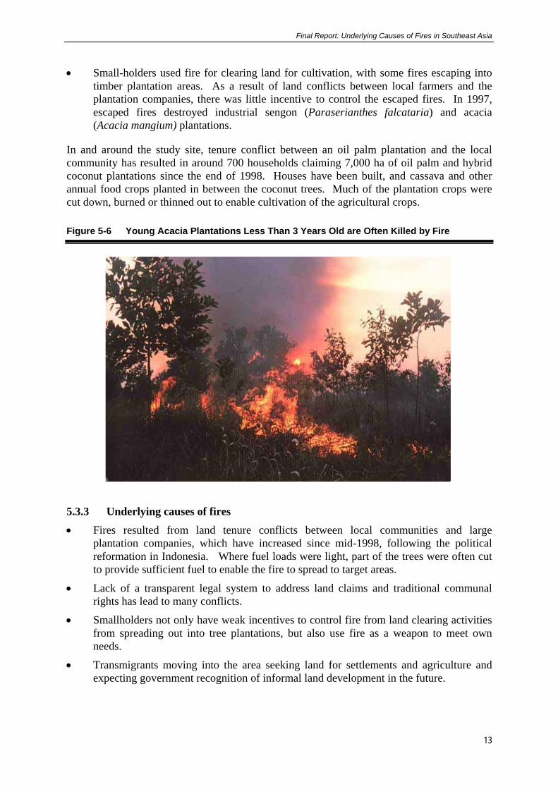
• Small-holders used fire for clearing land for cultivation, with some fires escaping into timber plantation areas. As a result of land conflicts between local farmers and the plantation companies, there was little incentive to control the escaped fires. In 1997, escaped fires destroyed industrial sengon (Paraserianthes falcataria) and acacia (Acacia mangium) plantations.
In and around the study site, tenure conflict between an oil palm plantation and the local community has resulted in around 700 households claiming 7,000 ha of oil palm and hybrid coconut plantations since the end of 1998. Houses have been built, and cassava and other annual food crops planted in between the coconut trees. Much of the plantation crops were cut down, burned or thinned out to enable cultivation of the agricultural crops.
Figure 5-6 Young Acacia Plantations Less Than 3 Years Old are Often Killed by Fire
5.3.3 Underlying causes of fires
• Fires resulted from land tenure conflicts between local communities and large plantation companies, which have increased since mid-1998, following the political reformation in Indonesia. Where fuel loads were light, part of the trees were often cut to provide sufficient fuel to enable the fire to spread to target areas.
• Lack of a transparent legal system to address land claims and traditional communal rights has lead to many conflicts.
• Smallholders not only have weak incentives to control fire from land clearing activities from spreading out into tree plantations, but also use fire as a weapon to meet own needs.
• Transmigrants moving into the area seeking land for settlements and agriculture and expecting government recognition of informal land development in the future.
Final Report: Underlying Causes of Fires in Southeast Asia
14
• The large-scale clearing required for plantation development was also found to be a major source of fire in the area, as it was used to remove debris from the site prior to planting.
• Inadequate fire management plans, institutional arrangements and facilities in plantations deter effective fire prevention and suppression in industrial tree plantations.
5.3.4 Policy issues
• Plantation development does not take into account the existing land claims of local communities. This may require the development of a special program, which may be possible under decentralization, as many of the land use planning procedures and decisions will be made at the provincial and district level.
• Land use rationalization is needed, both at the national and provincial levels is an area that has potential to improve under decentralization.
• Alternative methods of land clearing for plantation development with minimal use of fire exist and if implemented would reduce the negative effects of fire.
• Companies do not invest in adequate fire management (institutional, technical and social aspects) to protect their resources from accidental or escaped fires.
• Local institutions are short of resources to build up awareness and involve community participation in fire prevention and suppression.
5.4 Menggala Swampland Subsite The major farming system in the swamplands is “sonor”, a traditional rice cultivation technique, now practised both by the ethnic Mesuji people and the migrants to the area. The sonor system involves preparation of the ground through burning during drought periods usually associated with an El Niño event. This act and contributes significantly to fire smoke and haze problems in this area. The establishment of plantations and transmigration settlements has also increased the burning in swamp areas especially during the annual dry season. There is no effort to control fires that escape into forestland outside the area targeted for burning. 5.4.1 Land cover changes
The analysis of the Landsat MSS image showed that in 1984, about 91 % of the land was still covered by dry lowland and swamp forest. Lowland forest covered about 34 % of the area, mostly in the west, and swamp forest covered 57 % of the area mostly along the river banks and towards the coast in the east. Besides some riverine forest, the remainder of the area consisted of grasslands. The Landsat TM image for 1999 showed a dramatic change in land cover from that of 1984. All lowland forest had disappeared. Low-density swamp forests located mainly along the rivers and associated with “sonor” cultivation covered about 25 % of the area. New oil palm plantations established after 1984 covered 28 % of the area in 1999, while the mosaic of grassland and open scrubland associated with fire had increased by more than 300 %. The establishment of new settlements and agricultural areas associated with transmigration schemes also contributed to the decline in forest area. Burn scars were visible in areas of scrub/grassland, mixed agriculture and young plantation areas.
Final Report: Underlying Causes of Fires in Southeast Asia
15
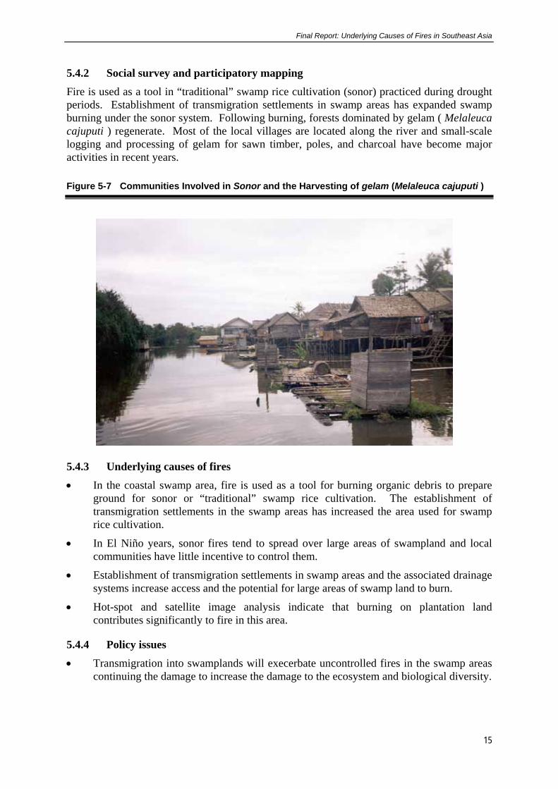
5.4.2 Social survey and participatory mapping
Fire is used as a tool in “traditional” swamp rice cultivation (sonor) practiced during drought periods. Establishment of transmigration settlements in swamp areas has expanded swamp burning under the sonor system. Following burning, forests dominated by gelam ( Melaleuca cajuputi ) regenerate. Most of the local villages are located along the river and small-scale logging and processing of gelam for sawn timber, poles, and charcoal have become major activities in recent years.
Figure 5-7 Communities Involved in Sonor and the Harvesting of gelam (Melaleuca cajuputi )
5.4.3 Underlying causes of fires
• In the coastal swamp area, fire is used as a tool for burning organic debris to prepare ground for sonor or “traditional” swamp rice cultivation. The establishment of transmigration settlements in the swamp areas has increased the area used for swamp rice cultivation.
• In El Niño years, sonor fires tend to spread over large areas of swampland and local communities have little incentive to control them.
• Establishment of transmigration settlements in swamp areas and the associated drainage systems increase access and the potential for large areas of swamp land to burn.
• Hot-spot and satellite image analysis indicate that burning on plantation land contributes significantly to fire in this area.
5.4.4 Policy issues
• Transmigration into swamplands will execerbate uncontrolled fires in the swamp areas continuing the damage to increase the damage to the ecosystem and biological diversity.

Final Report: Underlying Causes of Fires in Southeast Asia
16
• Forest and fire management for the production of M. cajuputi could lead to more stable land use and sustainable income generation options for rural communities in the swamp areas.
• Partnerships with communities to explore more appropriate land uses in the swamp areas, to limit swamp fires, and investigate the potential for mixed cropping of rice and M. cajuputi may be an effective way to reduce environmental degradation caused by fire. Technical inputs will also improve rice varieties or substitute crops to maximize production.
• Burning for plantation development is unwarranted in all situations, so alternatives to reduce unnecessary burning would be beneficial as discussed for other similar situations.
• Burning in swamplands may lead to huge impacts in terms of carbon dioxide emissions, changes to forest types and dramatic changes to livelihoods of communities over large areas and across different ethnic groups.
5.5 Musi Banyu Asin - South Sumatra Province
The Musi Banyu Asin (MUBA) site was chosen for a number of reasons. The occurrence of hot spots in the area during 1997 fires was dense, when compared to other parts of Sumatra and Kalimantan. Of all the eight study areas, the swamp forest areas surrounding MUBA to the north and east appears to have burned the most extensively. This was confirmed in the province-level analysis using full Landsat TM images. Additionally, since much of the area that burned was formerly swamp forest, the peat soils and corresponding vegetation were likely responsible for much of the smoke that drifted across Indonesia and other portions of Southeast Asia. In addition, the EU Forest Fire Prevention and Control Project based in Palembang, South Sumatra, suggested that this was an important area of study that was outside their focus sites. As such our results would provide important input to this project and complement existing studies. 5.5.1 Location
The Musi Banyu Asin site, which covers 253,400 ha, is located in the coastal swamplands of South Sumatra Province (Figure 5-8). Since the early 1980s, this site has become dominated by transmigration settlements. Most of the swamp forests in the area have now disappeared mainly due to logging (both legal and illegal), which were followed by fires and transmigration development. In 1997, large-scale fires burned up to 45 % of the land area of the site destroying most of the remaining, albeit degraded, swamp forest. The largest, single, contiguous burnt area was almost 32,000 ha in size producing much smoke in the process. The majority of large fires in 1997 started as small, deliberately fires that rapidly got of control. These fires were started by the activities of illegal loggers, fishermen, and swamp rice cultivators, and were exacerbated by the dry climatic conditions, large fuel loads and draining of the swamps for transmigration schemes, thus providing large areas of dry grasslands.

Final Report: Underlying Causes of Fires in Southeast Asia
17
Figure 5-8 Location of Musi Banyu Asin Site, South Sumatra Province
5.5.2 Land cover changes
According to Landsat MSS image analysis from1986, 50 % of the study area was covered by natural forest, comprising 74 % swamp forest, 20 % estuarine forest and 6 % mangrove forest. Approximately 23 % of the site was covered by non-forest vegetation such as riverine vegetation, scrub and grassland, and swamp scrub. Mixed agriculture only accounted for 3 % of the site. Burn scars were detected in areas where transmigration development was taking place. The analysis of Landsat TM imagery from 1992 shows a 14 % decline in natural forest compared to 1986. The analysis showed that 80 % of the high density swamp forest was degraded to low-density swamp forest with logging over six years. A 400 % increase in agricultural area was associated with the expansion of the transmigration schemes. The most striking feature of land cover analysis undertaken (Landsat TM image) in 1998 as compared to that in 1992 is the 428 % increase in burn scars. About 45 % of the land area of the site burned in 1997. Most (64 %) of the burn scar area was located in former swamp forest as indicated by 1992 imagery. The area of natural forest remaining in 1998 was only 10 % of the study area, which is a 77 % decrease compared to that in 1992.

Final Report: Underlying Causes of Fires in Southeast Asia
18
Figure 5-9 Land Cover Changes from 1986-1998 in the Musi Banyu Asin Site
5.5.3 Social survey and participatory mapping
Since the early 1980s, the drainage of swamps for the establishment of transmigration schemes has caused a lowering of the water table. This has led to a general drying out of the swamp forest. As a result, fire risk is very high during El Niño years and most annual dry seasons. Illegal logging in the swamp forest has opened up the forest canopy, resulting in an increase in shrubs, grasses and logging debris. These conditions lead to the area becoming more susceptible to fire in dry years. In addition, the establishment of canals for transporting the logs and draining the swamps leads to further drying out of the forest environment. These characteristics result in larger, hotter and more widespread fires when they are deliberately started or invade from outside the area.
5.5.4 Underlying causes of fires
• The majority of large fires in 1997 were started as small, deliberate fires that rapidly got out of control in the dry conditions and escaped into areas of degraded swamp forest. The causes of these fires were mainly the activities of illegal loggers and fishermen, and the burning for development of transmigration schemes.
• Transmigration developments that started in the late 1970s have created a fire-prone landscape. The extensive network of drainage canals not only opened up access to the

Final Report: Underlying Causes of Fires in Southeast Asia
19
area but also lowered the water table in the surrounding swamp forests, increasing fire incidence and susceptibility.
• Illegal logging in the swamp forests surrounding the transmigration areas increased rapidly in the 1980s. In combination with legal logging, these illegal activities severely degraded the swamp forests to the point where fire can easily get out of control.
• In addition to social and biophysical conditions that predisposed these forests to fire, the confusion over land status and the absence of formal management also provided no incentives to stop the spread of the fires in these open access areas.
• Another source of fire in some small parts of the area was the preparation of land for swamp rice cultivation. Many of these fires burned beyond the intended area, into adjacent degraded forest areas.
5.5.5 Policy issues
• A review of land allocation policies in swamplands, particularly those on deep peat soils, with a view to restricting or reducing the allocation of swamp lands for establishment of transmigration settlements in future national and regional plans is important. This is particularly relevant under decentralization or land use planning.
• Improved land and fire management practices for swamp areas and provision of technical assistance for sustaining existing transmigration schemes in swamp areas would help to reduce the incidence of fires. For example, some of the tidal transmigration schemes may be more suitable for aquaculture than rice production.
• The management of Protected Forests is poor with regard to avoiding degradation of mangroves through the establishment of shrimp ponds. In the two years from 1998 to 2000, large areas of mangroves were converted to shrimp ponds.
• Increased resources to local institutions for education, building awareness and strengthening of community participation in fire prevention and fire suppression efforts could be used to promote more sustainable livelihoods in the swamplands.
• By 1999, the natural forests of northeast part of the province were reduced to small areas on the banks of rivers and mangroves in tidal areas. This situation is indicative of the whole province apart from the mountainous areas in the west.
5.6 Tanah Tumbuh - Jambi Province The area of oil palm plantation area in Indonesia increased from 120,000 ha in 1969 to almost 3 million ha in 1999. Commonly, fire is used in land clearing and the removal of organic logging debris because it is cheap and effective. Land tenure conflicts between local communities and large plantation companies have lead to arson attacks on the plantations and infrastructure, particularly since the start of the Reformation Period in mid 1998. Oil palm development has contributed considerably to fire and smoke problems in Indonesia due to these two issues. This site represents a case study of the relation between oil palm development and fires, and the interaction between local communities and the plantation companies. 5.6.1 Location
Final Report: Underlying Causes of Fires in Southeast Asia
20
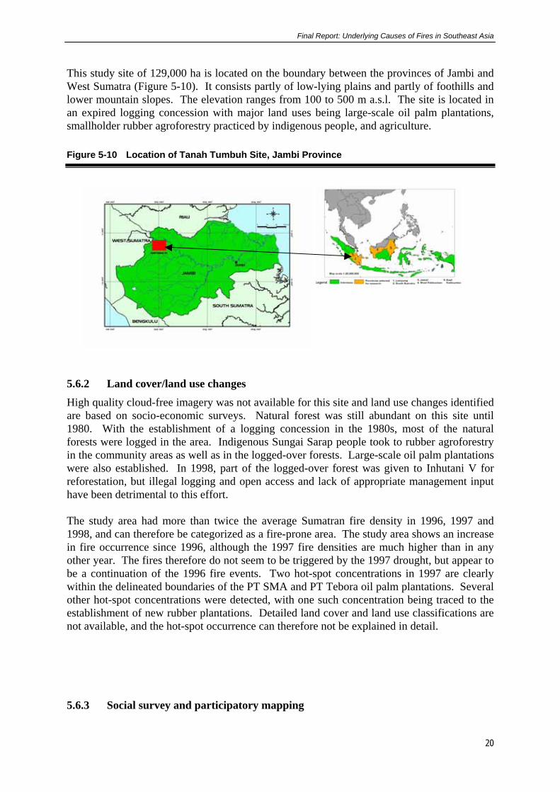
This study site of 129,000 ha is located on the boundary between the provinces of Jambi and West Sumatra (Figure 5-10). It consists partly of low-lying plains and partly of foothills and lower mountain slopes. The elevation ranges from 100 to 500 m a.s.l. The site is located in an expired logging concession with major land uses being large-scale oil palm plantations, smallholder rubber agroforestry practiced by indigenous people, and agriculture.
Figure 5-10 Location of Tanah Tumbuh Site, Jambi Province
5.6.2 Land cover/land use changes
High quality cloud-free imagery was not available for this site and land use changes identified are based on socio-economic surveys. Natural forest was still abundant on this site until 1980. With the establishment of a logging concession in the 1980s, most of the natural forests were logged in the area. Indigenous Sungai Sarap people took to rubber agroforestry in the community areas as well as in the logged-over forests. Large-scale oil palm plantations were also established. In 1998, part of the logged-over forest was given to Inhutani V for reforestation, but illegal logging and open access and lack of appropriate management input have been detrimental to this effort. The study area had more than twice the average Sumatran fire density in 1996, 1997 and 1998, and can therefore be categorized as a fire-prone area. The study area shows an increase in fire occurrence since 1996, although the 1997 fire densities are much higher than in any other year. The fires therefore do not seem to be triggered by the 1997 drought, but appear to be a continuation of the 1996 fire events. Two hot-spot concentrations in 1997 are clearly within the delineated boundaries of the PT SMA and PT Tebora oil palm plantations. Several other hot-spot concentrations were detected, with one such concentration being traced to the establishment of new rubber plantations. Detailed land cover and land use classifications are not available, and the hot-spot occurrence can therefore not be explained in detail. 5.6.3 Social survey and participatory mapping

Final Report: Underlying Causes of Fires in Southeast Asia
21
• A large fire in 1997/1998 in this area resulted from land clearing activities for the establishment of an oil palm plantation. Between 1994 and 1999, two oil palm companies cleared 9,500 ha of land by using fire.
• Fire was used by smallholders in the establishment of rubber agroforests, with a change from shifting cultivation to a more intensive tree-based farming system.
• In order to establish tree crop plantations, farmers were resettled and subjected to military intimidation in this process. Farmers resented the unfair treatment by the tree crop companies and used the opportunity provided by the “Reformasi” period in Indonesia in mid-1998 to reclaim their land and to seek revenge. Fire was used as a weapon in the reclamation efforts, by burning the plantations and associated infracture.
Figure 5-11 Burnt out Office Belonging to a Plantation Company
5.6.4 Underlying causes of fires
• Although government regulations were issued in 1995 determining that the use of fire in land clearing is no longer permitted, use of slash-and-burn techniques by large and small companies is still practiced for land clearing. In this study site, the use of fire for large-scale oil palm establishment was a major cause of fires in 1997.
• Inequitable land allocation policy associated with the development of oil palm plantations often created tenure conflicts between companies and communities who live around them. Fire is used as a weapon both by large-scale companies and smallholders in these conflicts to destroy assets.
• Slash-and-burn techniques are also used by smallholders for the establishment of rubber plantations. A high rate of newly established rubber gardens was identified in the areas associated with claims of “private” ownership in communal land.
5.6.5 Policy issues

Final Report: Underlying Causes of Fires in Southeast Asia
22
• A total ban on the use of fire in land clearing is currently impractical. Alternative, intermediate-level regulations and policy change appear to be more feasible, including the following: A total ban on the use of fire to clear land can be applied only during El Niño years or other critical times and on deep peat soils. Burning to clear land could be allowed in more normal years using techniques which reduce the amount of smoke and haze.
• Reducing the amount of timber that is burned could be analyzed by (1) developing a method of selling the timber residues both from large and small scale logging industries to medium density fiberboard (MDF) or pulp factories; (2) removing all policy barriers (tax and levy) at national and regional level to facilitate marketing timber residues, and (3) improve the infrastructure and institutional policies to increase the demand for the wood based residue.
• Reduced land tenure conflict between large-scale companies and smallholders may be possible by reviewing the allocation policy (RTRWP or Provincial Land Use Plan and Agrarian law) to take into account the existing land claims of local communities to minimize conflicts over land allocation.
• Promote sustainable land use by smallholders by (1) promoting rubber agroforestry systems using the sisipan technique to help reduce fire and smoke normally associated with tree crop development; (2) providing technical assistance for improving the agricultural extension system, and by providing good quality planting material to improve rubber productivity.
5.7 Sanggau - West Kalimantan The Sanggau study site is located in the central part of West-Kalimantan Province, between the cities Sanggau and Sintang along the Kapuas River (Figure 5-12). The landscape within this site includes a mosaic of indigenous shifting cultivation and agroforestry, along with several oil palm, timber plantation and transmigration projects at various stages of development. In 1999,only a few islands of primary forest remain in the northern areas of the site, significantly less than in the late 1980s. A fire-prone swathe bisects the site, along the border between major watersheds, which also represents the contested historic frontier between the Mualang and Jangkang Dayak peoples. The extensive grasslands and brushlands in this border region were formed mainly over the last century, resulting largely from a combination of fires used for hunting and little motivation to control shifting cultivation fires in this area of ambiguous and contested land rights. The focus of the research was on fires that occurred during the 1990’s, with background data on settlement and landscape histories from prior periods.
Figure 5-12 Location Map of the Sanggau Site in West Kalimantan

Final Report: Underlying Causes of Fires in Southeast Asia
23
5.7.1 Land cover changes During the period 1991–2000 there were considerable changes in the extent and quality of the natural forest. The total deforestation over this 9-year period was 42 % or 5 % per annum. The forest type most affected was high-density forest, which was reduced by 10,000 ha, or 44 %. Low-density forest was also reduced by 37 % from 1991. Mixed agriculture/savanna and grassland is still the dominant cover class, covering 85 % of the study area in 2000, increasing from 71 % in 1991. Burn scars decreased by 83 % from 1991. Underestimation of the area of the burn scars in 2000, estimated from satellite image analysis could be a result of regeneration of burnt Imperata sp. within a short time after the recent extensive fires of 1997 and 1999. Forty six percent of the burnt areas in 2000 were classified as burn scars in 1991 as well. The existence of mixed agriculture/savanna and Imperata grassland as the most dominant land cover in the study area has certainly increased the chance of fires in the area. Most of the burn scars were located in or adjacent to mixed agriculture/savanna and Imperata grassland.
5.7.2 Social survey and participatory mapping
The causes and the effects of fire within the Sanggau site are generally associated with the area’s “frontier” history of settlement, resource use, resource access and control patterns, which continue to form the basis for the development of the landscape on this site. A portion of the fires that have recently contributed to shaping this landscape can be attributed to timber and oil palm plantation expansion and contested control over land and resources that may either precede land expropriation or follow in its wake. Fires in such cases include some that local residents believe were set by plantation staff to speed up negotiations with local communities to obtain land for plantations, as well as fires set by village people to re-claim property they believed was illegally or erroneously cleared by plantation companies (see Figure 5-13). However, the majority of the uncontrolled fires were attributed to swidden fires, which spread out of control under exceptionally dry conditions, and to ill-guided household decisions to burn under high-risk weather conditions. This was exacerbated by increasingly fire-prone vegetation, inadequate safety measures during and immediately after burning, and weakened customary controls that no longer effectively define strict liability or enforce strong sanctions for damage due to negligent burning. Neither customary nor formal government sanctions
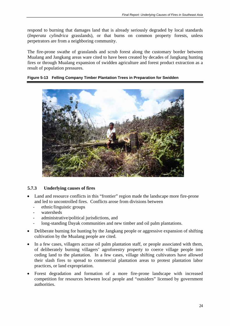
Final Report: Underlying Causes of Fires in Southeast Asia
24
respond to burning that damages land that is already seriously degraded by local standards (Imperata cylindrica grasslands), or that burns on common property forests, unless perpetrators are from a neighboring community. The fire-prone swathe of grasslands and scrub forest along the customary border between Mualang and Jangkang areas ware cited to have been created by decades of Jangkang hunting fires or through Mualang expansion of swidden agriculture and forest product extraction as a result of population pressures.
Figure 5-13 Felling Company Timber Plantation Trees in Preparation for Swidden
5.7.3 Underlying causes of fires
• Land and resource conflicts in this “frontier” region made the landscape more fire-prone and led to uncontrolled fires. Conflicts arose from divisions between
- ethnic/linguistic groups - watersheds - administrative/political jurisdictions, and - long-standing Dayak communities and new timber and oil palm plantations.
• Deliberate burning for hunting by the Jangkang people or aggressive expansion of shifting cultivation by the Mualang people are cited.
• In a few cases, villagers accuse oil palm plantation staff, or people associated with them, of deliberately burning villagers’ agroforestry property to coerce village people into ceding land to the plantation. In a few cases, village shifting cultivators have allowed their slash fires to spread to commercial plantation areas to protest plantation labor practices, or land expropriation.
• Forest degradation and formation of a more fire-prone landscape with increased competition for resources between local people and “outsiders” licensed by government authorities.
Final Report: Underlying Causes of Fires in Southeast Asia
25
• Decreasing effective accountability or liability for damages resulting from “traditional” indigenous shifting cultivation/agroforestry fire practices within an increasingly fire-prone landscape. Perpetrators also do not have the resources to restore or compensate for large-scale damages to agroforestry property due to negligent use of fire, as per local customary law sanctions.
• Village residents have not been eager to help suppress fires on former customary lands that they have already released to timber or oil palm plantations, unless those fires threaten their own remaining forest gardens or houses.
5.7.4 Policy issues
• Encouraging and assisting, directly or through representative NGOs, any local institutional developments, viable land use systems, and empowerment activities that reinforce community cohesion would assist to facilitate the prevention and suppression of uncontrolled fires.
• Outright prohibition of burning by smallholders or administered burn permit system would be unlikely to gain acceptance, and thus would be impossible to enforce.
• Material assistance in the form of equipment and training of village fire users may help prevent swidden fire escapes.
• Government assistance to prevent and suppress fires must be prompt and respectful of local communities’ existing values, knowledge, and capabilities.
• Large enterprises with well-developed infrastructure, such as timber and oil palm plantations, would be useful foci for regional efforts to prevent, contain, and suppress uncontrolled fires.
• Commercial concession holders should not be assumed to be responsible for all fires on any land nominally within their concessions. A major reform is required in the concession-granting process - boundaries should be delineated more carefully, at appropriate scales, and in consultation with local communities, to ensure that only areas that the company will actively manage will be included within the concession.
• More effective and just allocation and enforcement of land and resource rights, which may be facilitated under, decentralized decision-making.
5.8 Tumbang Titi - West Kalimantan The Tumbang Titi site is located in Ketapang district, West Kalimantan Province (Figure 5-14). The area is low-lying and elevation ranges from 10 to 75 meters a.s.l. The Tumbang Titi area had a high frequency and density of hot spots in 1997 compared to other parts of Kalimantan. Imperata grassland indicative of highly degraded and unmanaged land covers large areas of this study site and were most affected by the 1997 fires.

Final Report: Underlying Causes of Fires in Southeast Asia
26
Figure 5-14 Location Map of Tumbang Titi Site in West Kalimantan Province
5.8.1 Land cover changes
Landstat TM and SAR Image level analysis indicated that natural forest decreased from 473,300 ha (54 % of the area) in 1989 to 127,335 ha (15 % of the area) in 1996. Socio-economic research at the landscape level indicated that alang-alang (Imperata cylindrica) accounted for almost 22 % of the land cover of the study area. In 1997, large-scale fires burned 29 % of the land area of the site. Imperata grassland accounted for most of the area burnt, followed by primary forest (10 %), and secondary forest (10 %). Small proportions of smallholder rubber (6 %) and oil palm (9 %) plantations were also burned in 1997. Fire occurrence in this study site appears to be significantly correlated with the distribution of Imperata grassland, as around 86 % of these grasslands burned in 1997, while the proportion of other vegetation burned was less than 20 %. After the 1997 fires, the area of Imperata increased by 16 % in 1998. It is expected that, if fires are frequent, Imperata will gradually become more dominant throughout the entire region. 5.8.2 Social survey and participatory mapping
Socio-economic research indicated three phases of land use change on this study site. First, the widespread development of fire-prone Imperata grasslands as the final stage of land degradation in most of the area, following the intensive exploitation and conversion of rain forest through logging and short-rotation shifting cultivation (with increased land pressures) (see Figure 5-15). Second, the conversion of large areas of Imperata grasslands into oil palm plantations integrated with transmigration settlements, smallholder rubber plantations, and large-scale timber plantations from the mid-1990s onwards. And third, local community shift to more profitable land use activities such as gold mining in the wake of the economic crisis since 1997. Uncontrolled gold mining has caused widespread land degradation leading to large areas of exposed soil, erosion and down stream sedimentation. One subsite, Serengkah, has almost no Imperata. The area is hilly and still covered in primary forest (29 % of sub-site) protected by local communities. The incentive to protect the forest is high, as the forest provides a major source of honey and income. There are also strong customary laws (adat) for land ownership and fire management in this area.
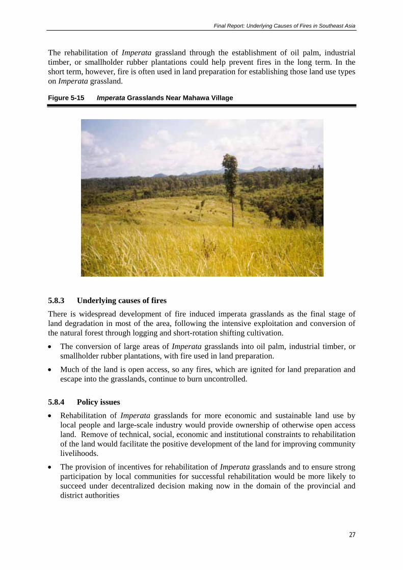
Final Report: Underlying Causes of Fires in Southeast Asia
27
The rehabilitation of Imperata grassland through the establishment of oil palm, industrial timber, or smallholder rubber plantations could help prevent fires in the long term. In the short term, however, fire is often used in land preparation for establishing those land use types on Imperata grassland.
Figure 5-15 Imperata Grasslands Near Mahawa Village
5.8.3 Underlying causes of fires
There is widespread development of fire induced imperata grasslands as the final stage of land degradation in most of the area, following the intensive exploitation and conversion of the natural forest through logging and short-rotation shifting cultivation.
• The conversion of large areas of Imperata grasslands into oil palm, industrial timber, or smallholder rubber plantations, with fire used in land preparation.
• Much of the land is open access, so any fires, which are ignited for land preparation and escape into the grasslands, continue to burn uncontrolled.
5.8.4 Policy issues
• Rehabilitation of Imperata grasslands for more economic and sustainable land use by local people and large-scale industry would provide ownership of otherwise open access land. Remove of technical, social, economic and institutional constraints to rehabilitation of the land would facilitate the positive development of the land for improving community livelihoods.
• The provision of incentives for rehabilitation of Imperata grasslands and to ensure strong participation by local communities for successful rehabilitation would be more likely to succeed under decentralized decision making now in the domain of the provincial and district authorities

Final Report: Underlying Causes of Fires in Southeast Asia
28
• Improving the agricultural extension system, and provision of good quality planting material would improve the rubber productivity.
• Priority development of small or large-scale plantations in Imperata grasslands with incentives for all of the land’s stakeholders could be promoted with an open and transparent decision making process which would provide security to investors, both large and small.
• If research on identification of timber species suitable for rehabilitating Imperata grassland and integrated with community development could be undertaken, additional livelihood options may be possible.
• Provision of a development plan and guidelines for gold mining activities in consultation with local communities would also assist with reducing the environmental problems in the region
5.9 Danau Sentarum - West Kalimantan The study site is located in the Danau (Lake) Sentarum area in the upper reaches of the Kapuas River in West Kalimantan (Figure 5-16), and covers around 250,000 ha of open lakes, seasonally flooded peat and freshwater swamp forest, surrounded by low hills. Most of the site falls within the Danau Sentarum National Park. Paleoecological analysis (Anshari et al. 2000) and historical records indicate that fire has been part of the Danau Sentarum landscape for a long time. Two general fire regimes appear to be present in the area. One is seen in the upland areas and along the larger rivers, where fire has been used for centuries as part of the swidden agriculture system. The other is seen in the low-lying swamp forests around the lakes where fires pose a severe problem during the dry season when the lakes dry out. The main reasons for the problem fires in the swamp areas are resource extraction, exacerbated by increased population and access, and dry conditions.
Figure 5-16 Location Map of Danau Sentarum Site in West Kalimantan Province
5.9.1 Fire and land cover changes

Final Report: Underlying Causes of Fires in Southeast Asia
29
Burn scar analysis showed that the area of burnt swamp forest in Danau Sentarum between 1973 and 1997 increased by 245 %, from 5,480 ha in 1973 to 18,900 ha in 1997. During 1973–1990, historically fire-prone dwarf swamp forest and stunted swamp forest were most affected by the fires and repeated burning was common. Image analysis confirms local reports of increased fires since the 1990s, with stunted swamp forest and tall peat swamp forest being the main types now affected. The increase in area burnt is accompanied by an increase in the overall size of individual burnt areas. The largest single burn scar in 1990 was 435 ha as compared to 1,340 ha in 1997. Areas previously burned appear to be more prone to burning in subsequent years, and tend to burn beyond the boundaries of the earlier burn.
Figure 5-17 Land Cover Changes in Danau Sentarum from 1973- 1997
5.9.2 Social survey and participatory mapping
Two different ethnic groups inhabit the area - the Melayu fishing community who live along
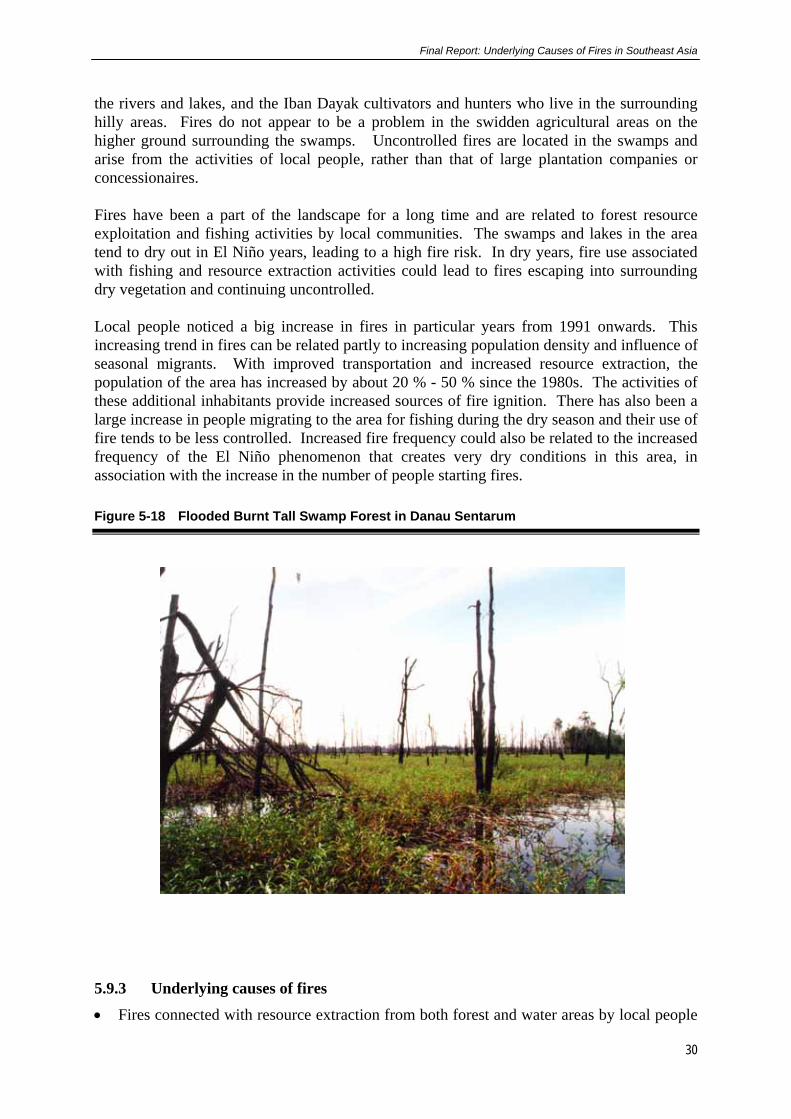
Final Report: Underlying Causes of Fires in Southeast Asia
30
the rivers and lakes, and the Iban Dayak cultivators and hunters who live in the surrounding hilly areas. Fires do not appear to be a problem in the swidden agricultural areas on the higher ground surrounding the swamps. Uncontrolled fires are located in the swamps and arise from the activities of local people, rather than that of large plantation companies or concessionaires. Fires have been a part of the landscape for a long time and are related to forest resource exploitation and fishing activities by local communities. The swamps and lakes in the area tend to dry out in El Niño years, leading to a high fire risk. In dry years, fire use associated with fishing and resource extraction activities could lead to fires escaping into surrounding dry vegetation and continuing uncontrolled. Local people noticed a big increase in fires in particular years from 1991 onwards. This increasing trend in fires can be related partly to increasing population density and influence of seasonal migrants. With improved transportation and increased resource extraction, the population of the area has increased by about 20 % - 50 % since the 1980s. The activities of these additional inhabitants provide increased sources of fire ignition. There has also been a large increase in people migrating to the area for fishing during the dry season and their use of fire tends to be less controlled. Increased fire frequency could also be related to the increased frequency of the El Niño phenomenon that creates very dry conditions in this area, in association with the increase in the number of people starting fires.
Figure 5-18 Flooded Burnt Tall Swamp Forest in Danau Sentarum
5.9.3 Underlying causes of fires
• Fires connected with resource extraction from both forest and water areas by local people

Final Report: Underlying Causes of Fires in Southeast Asia
31
have been cited as a cause since the first reports of fires in the 1800s. Many interviewees did not admit to deliberately using fire as a tool in improving fishing areas, but blamed others for such practices. Many of the fires in the 1980s may have been due to the search for the extremely valuable arowana fish in the swamp forests. Other causes include carelessness with cooking fires, use of fire for deer and turtle hunting, and for honey collection in the swamp forests. Under dry conditions, fires could easily spread.
• Increasing human population and increasing accessibility of the Danau Sentarum area has resulted in increased burning in the last decade. Besides increases in permanent residents, there have been large increases in seasonal migrant populations for dry-season fishing. Long-term residents indicated that they now had less control over their territories and outsiders tended to be more careless with fires.
• Increased frequency of the El Niño phenomenon, which is generally accompanied by very dry conditions in the Danau Sentarum area along with increased fire proneness of previously burnt areas could have resulted in increased burning in the last decade. Local people noticed a big increase in fires from 1991 onwards, especially in 1991, 1994, and 1997, all of which are known El Niño years.
• In some instances fire was used by villagers to deliberately burn fishing areas with conflicting claims.
• The unique hydrological regime of the lakes and swamps makes the area prone to fires. In El Niño years, the lakes and swamps dry out and fishing is at a premium. The combination of many people extracting resources and dried out vegetation leads to a very high risk of fire.
5.9.4 Policy issues
• The provision of increased resources to local institutions, in particular the Agency for Conservation of Natural Resources, for education, awareness and for community participation in fire prevention and suppression. This will lead to an increased understanding of the implications of fires in a landscape that has, in recent years, become heavily impacted by people from outside to the detriment of the local communities.
• By establishing multi-stakeholder participatory management for the Danau Sentarum National Park, there may be a chance to avoid further degradation of the swamp forests and natural resources. This will need to be carried out at the district level, with support from the Province. This report will be key in providing information to outline the serious problem that is arising.
• A review of the land allocation policies in swamp areas, particularly those on forested peat areas, including restricting or reducing the allocation of swamp forest for the establishment of oil palm plantations. This will need to be undertaken at the district level with Provincial government support. The importance of the swamp forests remaining in tact needs to be understood as further degradation of the ecosystem has both local and serious downstream impacts for the River Kapuas catchment.
• As the delineation and demarcation on the ground of the National Park and its buffer zone are inadequate, confusion over resource use is further exacerbated. It is imperative that under decentralisation, due to start in January 2001, that the relevant institutions undertake this activity. It should be followed-up with some village-level presentation to outline and explain the process and reason for the boundary marking, and to outline the various users permitted.

Final Report: Underlying Causes of Fires in Southeast Asia
32
• If the pattern of burning and ecosystem degradation continues it will have severe consequences for the integrity of the Park and for the people and their environment downstream. These developments and associated impacts of increased burning, conversion of forest to oil palm will have implications for the district in terms of changes to the economy and natural resource degradation, livelihood changes and perhaps an increase in land use conflicts.
5.10 Long Segar - East Kalimantan Province
This site located in East Kalimantan (Figure 5-19) has been drastically affected by the development efforts that have occurred in the area which have directly led to substantial fire damage in the recent El Niño event of 1997-98. As recently as 1980, this region was primarily covered by closed canopy, lowland dipterocarp forests. The timber companies came first, in the 1970s, followed by transmigration programs and industrial timber plantations in the 1980s, and most recently, by oil palm plantations. Sparsely populated in 1980, the number of people, of diverse origins has increased. The indigenous knowledge of the environment held by the original inhabitants is not shared by the newcomers, nor is the commitment to caring for the homeland.
Figure 5-19 Location Map of the Long Segar Site in East Kalimantan Province
5.10.1 Land cover changes
Landsat TM image analysis from 1990 showed that 62 % of the study area was covered by natural forest, most of which was fragmented dipterocarp forest (54 %), with only 10 % in
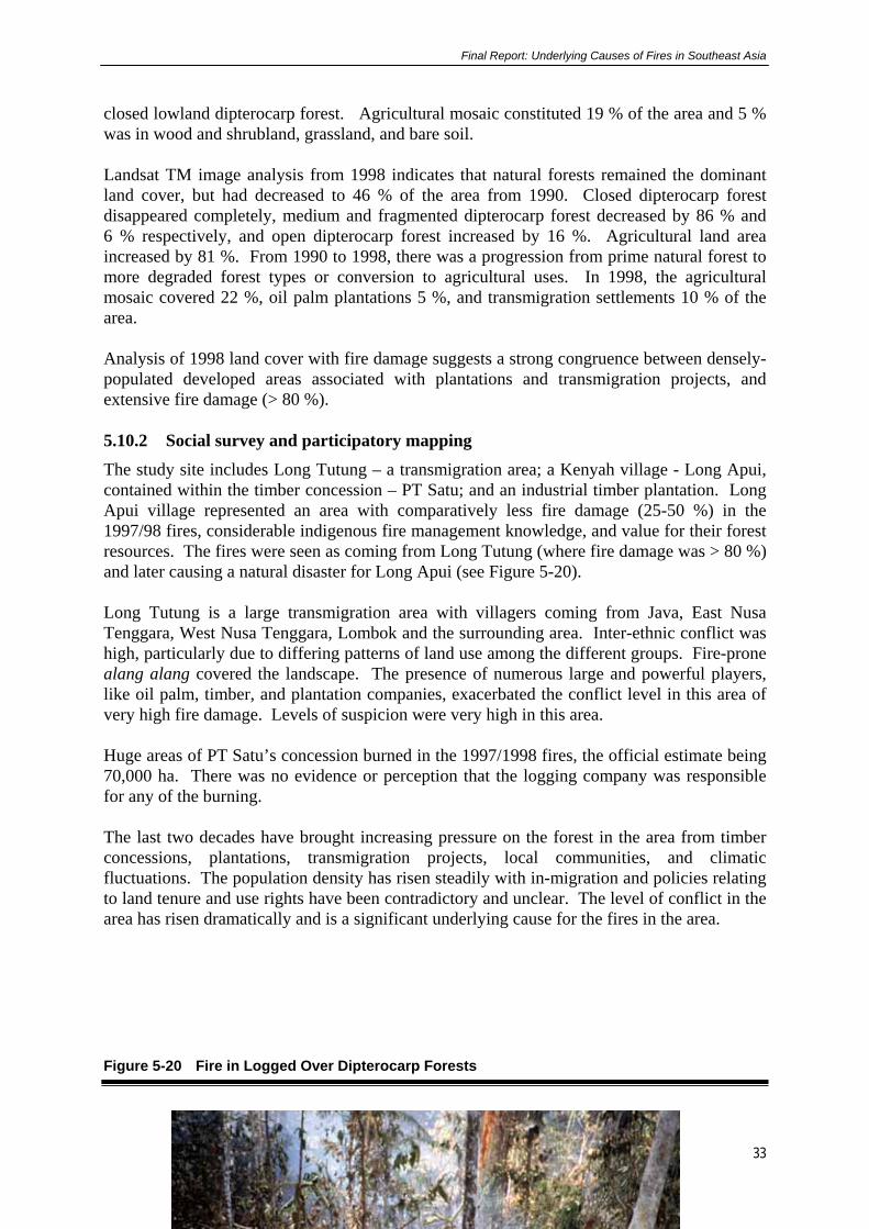
Final Report: Underlying Causes of Fires in Southeast Asia
33
closed lowland dipterocarp forest. Agricultural mosaic constituted 19 % of the area and 5 % was in wood and shrubland, grassland, and bare soil. Landsat TM image analysis from 1998 indicates that natural forests remained the dominant land cover, but had decreased to 46 % of the area from 1990. Closed dipterocarp forest disappeared completely, medium and fragmented dipterocarp forest decreased by 86 % and 6 % respectively, and open dipterocarp forest increased by 16 %. Agricultural land area increased by 81 %. From 1990 to 1998, there was a progression from prime natural forest to more degraded forest types or conversion to agricultural uses. In 1998, the agricultural mosaic covered 22 %, oil palm plantations 5 %, and transmigration settlements 10 % of the area. Analysis of 1998 land cover with fire damage suggests a strong congruence between densely-populated developed areas associated with plantations and transmigration projects, and extensive fire damage (> 80 %). 5.10.2 Social survey and participatory mapping
The study site includes Long Tutung – a transmigration area; a Kenyah village - Long Apui, contained within the timber concession – PT Satu; and an industrial timber plantation. Long Apui village represented an area with comparatively less fire damage (25-50 %) in the 1997/98 fires, considerable indigenous fire management knowledge, and value for their forest resources. The fires were seen as coming from Long Tutung (where fire damage was > 80 %) and later causing a natural disaster for Long Apui (see Figure 5-20). Long Tutung is a large transmigration area with villagers coming from Java, East Nusa Tenggara, West Nusa Tenggara, Lombok and the surrounding area. Inter-ethnic conflict was high, particularly due to differing patterns of land use among the different groups. Fire-prone alang alang covered the landscape. The presence of numerous large and powerful players, like oil palm, timber, and plantation companies, exacerbated the conflict level in this area of very high fire damage. Levels of suspicion were very high in this area. Huge areas of PT Satu’s concession burned in the 1997/1998 fires, the official estimate being 70,000 ha. There was no evidence or perception that the logging company was responsible for any of the burning. The last two decades have brought increasing pressure on the forest in the area from timber concessions, plantations, transmigration projects, local communities, and climatic fluctuations. The population density has risen steadily with in-migration and policies relating to land tenure and use rights have been contradictory and unclear. The level of conflict in the area has risen dramatically and is a significant underlying cause for the fires in the area.
Figure 5-20 Fire in Logged Over Dipterocarp Forests

Final Report: Underlying Causes of Fires in Southeast Asia
34
5.10.3 Underlying causes of fire
• Creation of a drier, more fire-prone landscape with conversion from humid tropical forest to overlogged (and degraded) tropical rain forest to industrial timber plantations, oil palm and other cash crop plantations, or transmigration agriculture.
• Inappropriate and uncoordinated land use allocation, introduction of major new actors into the area including logging companies, plantation companies, and others, increased fire risk.
• Influx of spontaneous and official migrants has increased the population density and potential sources of fire ignition in the area.
• In-migration has also altered the ethnic composition in the area. Resource use patterns, values, and use of fire differ among the different ethic groups, resulting in more uncontrolled fires and fire being used as a weapon to resolve conflicts.
• Insecurity of land tenure and perceptions of inequity have led to conflict and use of fire as a weapon between communities and communities and large corporations.
• Newcomers used to humid contexts are less familiar with the local dry environment and have less knowledge of fire use and management.
• Decrease in social capital increases the chances of fires caused by carelessness and a lack of interest in controlling them.
• Fire used by plantation companies as an inexpensive land clearing method and a means of acquiring more land.
• Increased use of uncontrolled fire as a tool as unfulfilled subsistence needs increase.
5.10.4 Policy issues
• Policies to prepare for, and control fire in the future, may need to emphasise local capabilities including local knowledge and institutions for fire management. Local people

Final Report: Underlying Causes of Fires in Southeast Asia
35
are always available in the region for monitoring, and they have the strongest motivation, under certain circumstances, to protect the resource.
• Policies that clarify legal rights to land, and strengthen the traditional rights of local communities in an equitable manner, in order to enhance local people’s willingness and interest in protecting local resources may need to be reviewed.
• Recognition of the inherent sources of conflict linked to development efforts as implemented, such as increased pressure on local resources, increased interaction among different ethnic groups, and between newcomers and indigenous groups may lead to fewer fires. Development efforts should devote explicit attention to processes likely to decrease such conflicts (which in turn lead to increased fire danger). These could include wider involvement in decisions about settlement and use patterns; orientation for transmigrants and receiving communities toward inter-ethnic co-operation and complementarities; or the development of explicit conflict resolution mechanisms in multi-stakeholder contexts.
• Policies for assessing and acting on the results of studies about the environmental impacts of development activities to be reviewed, since the most developed areas were the most fire-prone. Such efforts can build on existing assessment guidelines, with strengthened implementation.
• Policies that allow for resolution of conflicting claims, and greater co-ordination in the future allocation of rights to stakeholders as part of a rational integrated land use plan may lead to fewer fires. This could occur by continuing the trend toward clarification of traditional rights; and by strengthening co-ordination mechanisms among government departments. This is particularly important now that decentralization processes are underway.
• Policies that can place fire management concerns in the hands of those people closest to the areas in danger; and that logically should be local people, supported by regional government may be worth considering. This is possible in the context of decentralisation in Indonesia. An increase in fire management capacity, within the region, would benefit the people and the environment.
6. SYNTHESIS OF UNDERLYING CAUSES OF FIRE The development of a matrix with the different causes of fire on the range of site conditions can assist with identification of patterns on different sites with different site characteristics.
Final Report: Underlying Causes of Fires in Southeast Asia
36
The patterns are important in identifying solutions to the unwanted and destructive fires in many parts of Indonesia. 6.1 Direct Causes Based on the eight sites, the study found that there were a number of direct causes of fire on any one site. The study identified four main direct causes of fire as: • Fire being used to assist with land clearing,
• Fire used as a weapon in land tenure or land use disputes,
• Accidental or escaped fires,
• Fire connected with resource extraction.
The main direct causes of fire categorised under these four headings are provided in Table 6-1. In summary the following direct causes were identified:
• Land development strategies that favor large-scale operating units contributed significantly to fires in recent years. Large land owners, deliberately set fires on tracts of land as part of the preparatory land practice for the production of agricultural, or plantation crops and establishment of transmigration settlements. However, as well as large land owners, smallholders also deliberately set fires for land preparation either in the production of coffee, rubber or swidden agriculture. Swidden agriculture was relevant on the swamp sites and in parts of Indonesia which are less well developed where communities rely on more traditional agricultural pursuits and practices.
• The other large cause of fire resulted from large scale intentional burning of forest land to facilitate the production of plantations of coffee, oil palm, where fire escaped into adjacent open access forest land or timber plantation areas. The timber plantations in their early years are very susceptible to fire due to the high fuel loads in the understorey and volatility and susceptibility to fire of many tree plantation genera (Eucalyptus spp.).
• On a small number of the study sites, fires were set to facilitate resource extraction, including fishing, deer hunting, honey production, modification of habitat and access. Some of these fires escaped into forest land, which in many cases was dry and easily burned out of control over large of land that was largely regarded as open access,
• Arson was also a major cause of fire. This cause of fire was prevalent in many of the resource rich areas, where land is either scarce for agricultural production, and /or where there is resource conflict over tenure or access rights. These types of fire were particularly important in the areas with natural forest on fertile soils, areas where large landholders have resumed land for oil palm, and timber plantations.
The results from the study site, hot spot analysis and the use of satellite imagery which provided a view of what happened on a larger scale on the two islands enable relative weightings to be assigned to the direct causes of fire as indicative of the situation throughout the islands of Sumatra and (Borneo) Kalimantan. These are summarised in Table 6-2.
The two most important direct causes of fire in Indonesia, particularly Sumatra and Kalimantan are as a tool for land clearing or site preparation and accidental, or escaped fires. However, it should be noted that in most cases, the escaped fires came for the lack of incentive for people to manage the fire that was not on their land. Fire being used as a weapon to try and solve land use or tenure claims is moderate in importance while fire being

Final Report: Underlying Causes of Fires in Southeast Asia
37
used for resource extraction is of low importance. This ranking system also assists with the prioritising of policy issues that are relevant for numerous locations throughout Indonesia.
In the developing provinces of Riau and Jambi, large scale land clearing is being undertaken, much of it with the use of fire to remove unwanted biomass for plantation development. In other areas, small-holders also set fires for land clearing, while many other traditional communities use fire as part of their seasonally based livelihood activities. One issue that is common throughout the two islands is that many of the fires which were deliberately set for one purpose or another in the dry periods of the year, escaped beyond their intended boundaries and continued uncontrolled over large areas of forest land. The reasons for this are numerous and outlined in the next section. Another significant point is that on any site there were at least two major direct causes of fire. This is also understandable within the context of land use on the sites and is indicative for most parts of the western part of Indonesia. 6.2 Underlying Causes of Fire The study identified 6 major underlying causes of fire, many of which are closely related. On any one site, fire was attributed to more than one underlying cause as summarised in Table 6-1. 6.2.1 Land Tenure
By far the major underlying cause of fire across the sites was due to aspects related to tenure as shown in Table 6-11. On some sites in Sumatra where land was scarce for a certain enterprise, informal land tenure security was facilitated through occupation of national parks or disputed land designated to other parties through the use of fire. Fire was used to either clear natural forest or existing timber or oil palm plantations to enable other crops to be planted, to allow land to be resettled usually by small holders. A similar pattern was observed in other situations where "private" tenure was “recognised” as belonging to individuals who planted trees on communal lands. Fire was often used in the land preparation process. The underlying cause over all sites was the lack of incentive by local communities to control unwanted fire on land which was not their own, nor which they have responsibility or could derive benefit from directly. The cause here is due to a number of societal issues where the good of society is not given a high priority, tenure and institutional weakness. Also related to this are overlapping claims for land between many of the stakeholders in areas where resources are scarce and where the development pattern is already well defined e.g. in parts of Lampung Province. The issue relating to fire here is often related to the lack of a transparent legal system to address the various types of land and land use claims. As a result, fire is often used to retaliate for the lack of perceived justice, or to reduce the value of property under dispute, or making the occupation too expensive both in terms of security or loss of life or property. In Indonesia the issue of tenure and use rights and the use of fire is very important and is a fundamental problem which needs to be addressed. Solving this issue alone would reduce greatly the incidence of destructive fires, particularly when environmental and site conditions are more conducive to enabling deliberately set fires to burn fiercely.

Final Report: Underlying Causes of Fires in Southeast Asia
38
6.2.2 Land Use Allocation
The inappropriate, inequitable and uncoordinated allocation of land for different uses has resulted in fire being used to try and alter the centrally allocated land user or occupier of the land or forest by some stakeholders. The reasons for this are related to the lack of an effective legal system, or strong institutions for allocating land use. Corruption is also an issue associated with this. Hence fire is used as part of the solution. This question of how land use is allocated is important for many parts of Indonesia, where land use allocation was carried out by the central level government and enforced. In some instances, the same tract of land was allocated to different users and in other cases, the land allocated was totally inappropriate for the intended purpose, thus leading to conflicts. With decentralisation, the problem could continue unless institutions responsible for land use allocation are supported and strengthened and the institutions responsible for up holding the decisions are also supported by the law. 6.2.3 Economic Incentives/Disincentives
The profitability of alternative land uses of the forest land following the logging of natural forests is a major driving force for clearing the forests. In most cases fire is a cheap and effective tool for this purpose and until recently was not discouraged as a land use practice as part of the site preparation. The alternative land use to natural forest, which is often perceived as having no value, is often seen as profitable for small landholders producing coffee, rubber and also the large land owners producing oil palm, rubber and timber. Not only are there incentives provided to undertake this practice (use of Production Forest to be cleared for plantations), but there is a range of perverted development incentives and mechanisms which enabled the clearing of forests using fire to be undertaken on a large scale. These disincentives and mechanisms relate to the corrupt practices of the many businesses in acquiring land, and capital, small politically powerful elite too powerful to adhere to internationally acceptable business practices, ineffective and corrupt legal system and ineffective local institutions to protect the forest. This underlying cause is and will continue to be a very large reason for fire in Indonesia. Although the power sharing over land use allocation and implementation has now been decentralised, it is still too early to predict if the provincial and district authorities will instigate appropriate measures to address the issue in an equitable manner. It is important to support the provincial institutions who are working on these issues of resource allocation, forestry sector processing capacity, the legal system and financial institutions required to implement the plans in an effort to reduce one of the major underlying causes of fire. 6.2.4 Forest Degrading Practices
On a number of sites, the timber harvesting and related land management practices, drainage of swamps and the repeated fires in different forest types have all contributed to fires causing greater damage to these forest lands than would normally be the case. Given the fact that people have set the fires and they have either escaped, the poor and degrading land practices exacerbated by fire have resulted in greater environmental damage and have reduced the options and possibilities for rehabilitation of the environment in the presence of continued fire.
Given the state of forest management across Indonesia, this trend is likely to continue in areas

Final Report: Underlying Causes of Fires in Southeast Asia
39
where the forest has not been cleared for alternative land uses (Table 6-1). In Indonesia, over 1 million ha are logged annually. If timber harvesting techniques are not improved, and disturbed forests are not protected from fire, much of the logged-over forest will be reduced to shrubland or grassland by fire as is the case with much of the lowlands in Kalimantan, Kutai National Park, or parts of Bukit Barisan National Park in Lampung Province where coffee production is non undertaken.
6.2.5 Shift in Demographic Characteristics
Many areas have been subjected to large scale in-migration, where fire is used by the migrants and the authorities to clear the forest for settlements. Often these same migrants are unfamiliar with the use of fire in a different environment, resulting in escaped fires. In other cases migrants bring their own land use patterns and fire practices with them, which may involve use of fire on a different scale, or at a different time of the year when the control of the fires in their new environment is more difficult.
This underlying cause of fires is of moderate importance and is less likely to be an issue in the developed provinces than in the provinces where development is underway with migrants coming from outside the area. Generally in Indonesia, this problem is likely to be of lesser importance in many areas, apart from some specific locations where there are new migrants and forest areas are being cleared for agriculture (Table 6-1).
6.2.6 Inadequate Institutional Capacity
Institutional capacity was a problem on only a few sites where encroachment into national parks occurred and fire was used to remove vegetation to enable other crops to be produced. In many cases, unwanted fires could not be suppressed due to lack of capacity in terms of management planning for prevention, suppression in both natural forests and timber plantations. This situation in relatively low in importance and is less likely to be a major problem as plantation companies develop the institutional capacity to manage fire on their concessions. Institutional capacity is likely to continue to be a major issue in relation to protected areas where the human, financial and law enforcement resources are not available to strengthen the capacity of institutions whose role and responsibility is to protect and manage these valuable natural resources. Under decentralisation, it is still unclear in what organisation the responsibility for the protection of the natural forests will be vested. This is one area which will benefit from assistance in determining the natural forest boundaries and the best way for institutions to then protect them, along with maintaining the quality of the forests inside when the districts receive no immediate income from the forest.

Final Report: Underlying Causes of Fires in Southeast Asia
40
Table 6-1 Summary of Underlying Causes of Fire Based on the Eight Site in Sumatra and Kalimantan
SUMATRA KALIMANTAN UNDERLYING CAUSES OF FOREST AND FOREST LAND FIRES
Sekincau Menggala peneplains
Menggala swampland
Musi Banyuasin
Tanah Tumbuh
Sanggau Danau Sentarum
Tumbang Titi
Long Segar
Direct Causes Fires as a Tool in Land Clearing
Small holders
• Conversion of forests to alternative land uses (e.g. to coffee or rubber)
√
√
• Rotational tree cropping √ √ √
• Short rotation swidden √ √ √ √ √
Large holders (companies)
• Large-scale plantation development
√ √ √ √
• Transmigration sites √ √ √ √
Fire as Weapon in Land Tenure
Arson √ √ √ √ √
Accidental Fires (Escaped)
Land clearing/illegal logging √ √ √ √ √ √
Cooking /smoking/camping √ √ √
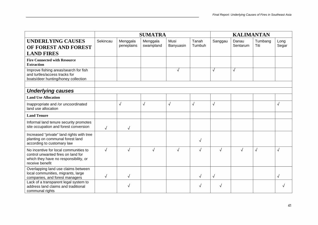
Final Report: Underlying Causes of Fires in Southeast Asia
41
SUMATRA KALIMANTAN UNDERLYING CAUSES OF FOREST AND FOREST LAND FIRES
Sekincau Menggala peneplains
Menggala swampland
Musi Banyuasin
Tanah Tumbuh
Sanggau Danau Sentarum
Tumbang Titi
Long Segar
Fire Connected with Resource Extraction
Improve fishing areas/search for fish and turtles/access tracks for boats/deer hunting/honey collection
√ √ √
Underlying causes Land Use Allocation
Inappropriate and /or uncoordinated land use allocation
√ √ √ √ √ √
Land Tenure
Informal land tenure security promotes site occupation and forest conversion
√
√
Increased “private” land rights with tree planting on communal forest land according to customary law
√
No incentive for local communities to control unwanted fires on land for which they have no responsibility, or receive benefit
√ √ √ √ √ √ √ √ √
Overlapping land use claims between local communities, migrants, large companies, and forest managers
√
√
√
√
√
Lack of a transparent legal system to address land claims and traditional communal rights
√
√
√
√
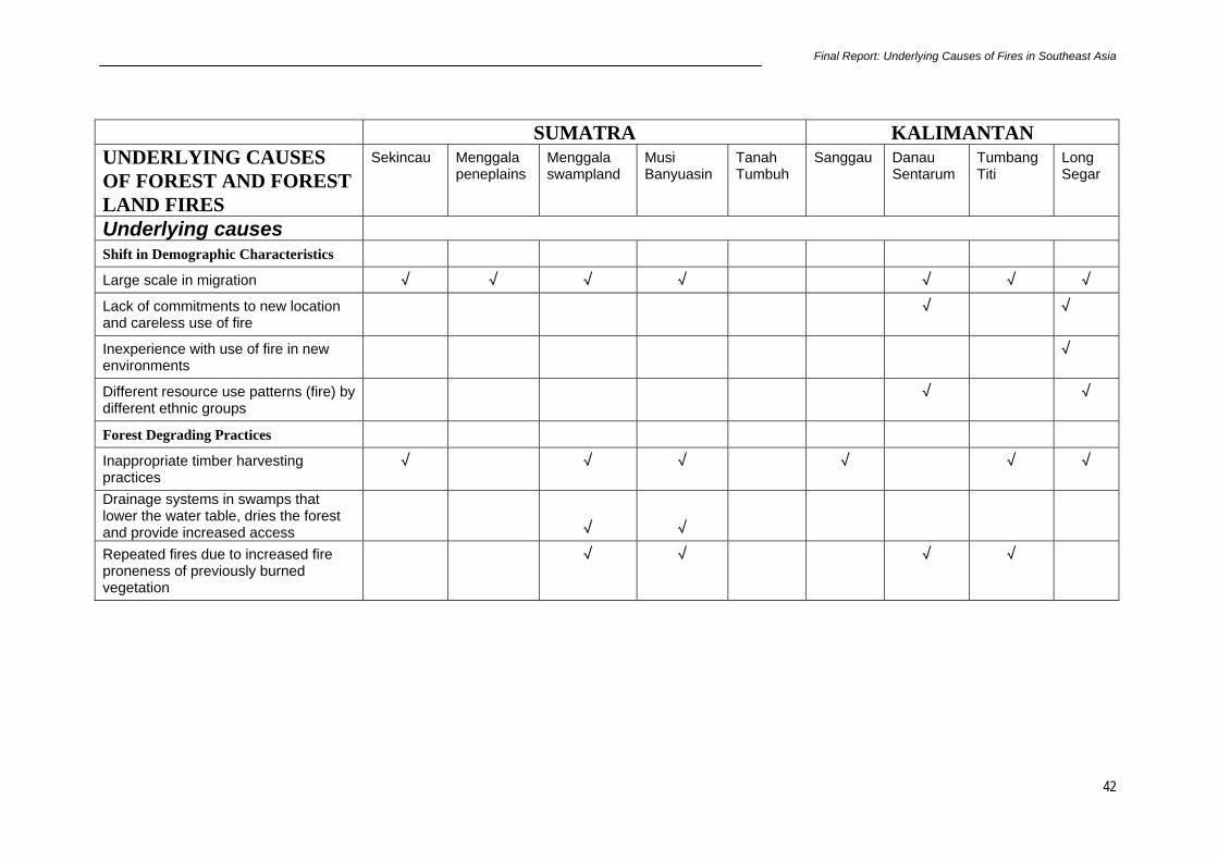
Final Report: Underlying Causes of Fires in Southeast Asia
42
SUMATRA KALIMANTAN UNDERLYING CAUSES OF FOREST AND FOREST LAND FIRES
Sekincau Menggala peneplains
Menggala swampland
Musi Banyuasin
Tanah Tumbuh
Sanggau Danau Sentarum
Tumbang Titi
Long Segar
Underlying causes Shift in Demographic Characteristics
Large scale in migration √ √ √ √ √ √ √
Lack of commitments to new location and careless use of fire
√ √
Inexperience with use of fire in new environments
√
Different resource use patterns (fire) by different ethnic groups
√ √
Forest Degrading Practices
Inappropriate timber harvesting practices
√ √ √ √ √ √
Drainage systems in swamps that lower the water table, dries the forest and provide increased access
√
√
Repeated fires due to increased fire proneness of previously burned vegetation
√ √ √ √

Final Report: Underlying Causes of Fires in Southeast Asia
43
SUMATRA KALIMANTAN UNDERLYING CAUSES OF FOREST AND FOREST LAND FIRES
Sekincau Menggala peneplains
Menggala swampland
Musi Banyuasin
Tanah Tumbuh
Sanggau Danau Sentarum
Tumbang Titi
Long Segar
Underlying causes Financial Incentives/Disincentives
Profitability of alternate land use (e.g. coffee, small holder rubber )
√ √
Profitability of alternate land use (e.g. oil palm, rubber, timber )
√ √ √ √
Perverse development processes and mechanisms
√ √ √ √
Inadequate Institutional Capacity
Lack of institutional capacity, resources and will to monitor and deal with encroachment and other illegal activities in forest areas
√
√
Inadequate forest and fire management plans, and facilities to prevent and suppress accidental or escaped fires in plantations and natural forests
√
√
√
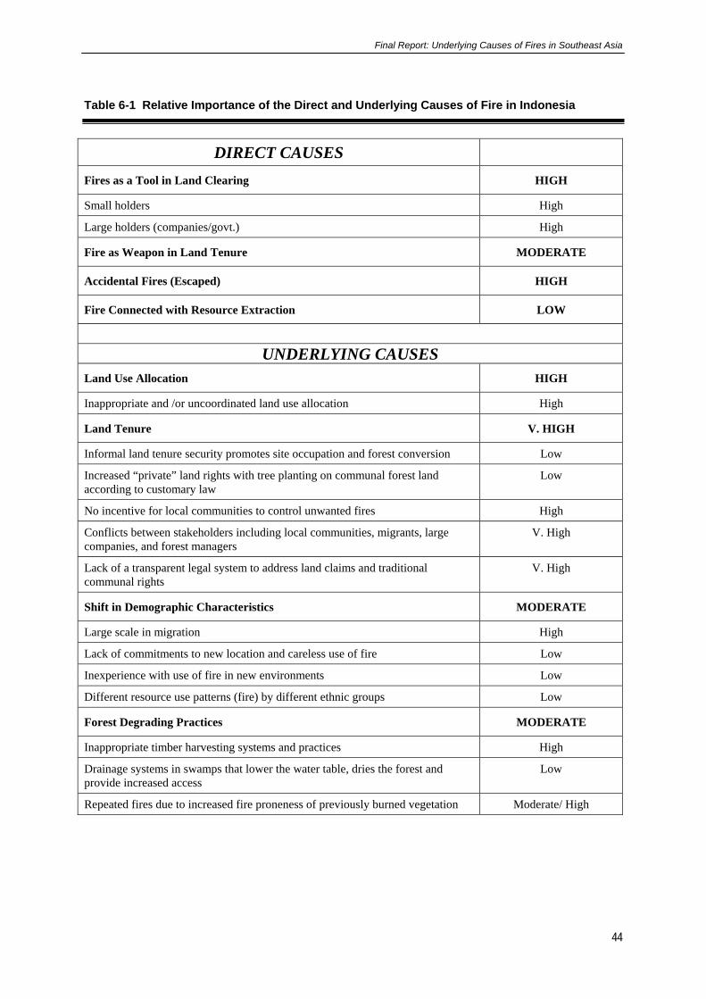
Final Report: Underlying Causes of Fires in Southeast Asia
44
Table 6-1 Relative Importance of the Direct and Underlying Causes of Fire in Indonesia
DIRECT CAUSES Fires as a Tool in Land Clearing HIGH
Small holders High
Large holders (companies/govt.) High
Fire as Weapon in Land Tenure MODERATE
Accidental Fires (Escaped) HIGH
Fire Connected with Resource Extraction LOW
UNDERLYING CAUSES
Land Use Allocation HIGH
Inappropriate and /or uncoordinated land use allocation High
Land Tenure V. HIGH
Informal land tenure security promotes site occupation and forest conversion Low
Increased “private” land rights with tree planting on communal forest land according to customary law
Low
No incentive for local communities to control unwanted fires High
Conflicts between stakeholders including local communities, migrants, large companies, and forest managers
V. High
Lack of a transparent legal system to address land claims and traditional communal rights
V. High
Shift in Demographic Characteristics MODERATE
Large scale in migration High
Lack of commitments to new location and careless use of fire Low
Inexperience with use of fire in new environments Low
Different resource use patterns (fire) by different ethnic groups Low
Forest Degrading Practices MODERATE
Inappropriate timber harvesting systems and practices High
Drainage systems in swamps that lower the water table, dries the forest and provide increased access
Low
Repeated fires due to increased fire proneness of previously burned vegetation Moderate/ High

Final Report: Underlying Causes of Fires in Southeast Asia
45
Economic Incentives/Disincentives V. HIGH
Profitability of alternative land use (e.g. coffee, small holder rubber ) Moderate
Profitability of alternative land use (e.g. oil palm, rubber, timber ) High
Perverse development processes and mechanisms V. High
Inadequate Institutional Capacity LOW
Lack of institutional capacity, resources and will to monitor and deal with encroachment and other illegal activities in forest areas
Low
Inadequate forest and fire management plans, and facilities to prevent and suppress accidental or escaped fires in plantations and natural forests
Low
7. POLICY ISSUES AND IMPLICATIONS Based on the identification of both direct and indirect causes of fire in this research on the underlying causes of fire, we have outlined some policy issues and implications (Table 7-1) for Indonesia. Two crucial policy issues relate to reducing fire as a tool in land clearing and land use allocation /land tenure problem, need to be addressed but not sufficient to solve the problem. Additional policies to reduce the impact on shifting demographic characteristics, to reduce forest degrading practices, to build economic incentives/disincentives and to strength institutional capacity are needed. 7.1 Policy Issues and Implications to Reduce Fires as a Tool in Land Clearing The first policy issue addressed is related to fire as a tool in land clearing. The Government of Indonesia issued a zero burning policy in 1994. Although this policy, it implemented, could directly reduce the fire problem, it is currently impractical to implement. Alternative, intermediate-level regulations and policy changes appear to be more feasible. Specific policy issues and implications which may reduce the impact of fire as a land clearing tool are as follows: • Review the zero burning policy. A total ban on the use of fire in land clearing is
currently impractical. Alternative, intermediate-level regulations and policy changes appear to be more feasible,
• Instigate a total non-burning practices when it does harm (El Niño period). Need to provide with accuracy early warning mechanisms to assist land managers for this to be feasible,
• Perform applied and adaptive research on zero or less burning technology, and use of fire with minimal smoke generation,
• Develop alternatives to unsustainable forms of short rotation swidden,
• Review current regulations on harvesting and trade of domestic timber (including timber from agroforestry species) that would decrease the amount of timber residue that is burned after timber harvesting operations.
Final Report: Underlying Causes of Fires in Southeast Asia
46
7.2 Policy Issues and Implications on Land Use Allocation and Land Tenure The second policy issue is related to land use allocation and land tenure policy. This policy is the most important accordingly to the main underlying (indirect) cause of fire. The study showed the direct cause of fire from fires that escaped is high. However, the accidental fires do not escape because of careless people in managing fire, but come from the lack of incentive for people to prevent and suppress fire because of lack of tenure. Lack of incentives for local communities to be involved in fire management, prevention or suppression are a major issue. The reasons for this involve issues related to security of tenure, conflict, and uncertainty of access rights where fire is used to force others to acquiesce. The improvement of security over the resource use or land, provided that tenure was obtained legally and in a non-corrupt manner would provide a sense of ownership and responsibility for the resource with the likelihood of greater involvement in its protection. Land use change involving large scale companies with connections to the political and financial elite and the allocation mechanisms and procedures led to the use of fire by both the displaced communities or individuals to degrade the assets, or by the companies in conjunction with security personnel, to destroy the few resources belonging to the communities or individuals in order to force them to move to other locations. In order to reduce fire used as a tool of destruction in land use disputes, policy issues would need to identify how boundaries could be rationalised using an open and transparent mechanism. Prior to this step, a mechanism would need to be developed in the provinces down to the district level, which involved all stakeholders, and elected representatives in determining land use and to ensure that land use was matched to the site characteristics. In some cases, fire is used as part of the process for obtaining land and to grow crops etc in order to legitimise ownership. Specific policy issues and implications are summarised as follows: • Land use rationalization is needed at both the national and provincial level with
community participation to promote sustainable land use. Examples: avoid transmigration projects in swamp areas and expansion of coffee production within the National Parks,
• Land allocation policy must be reviewed to take into account the existing land claims of local communities to minimize conflicts. Existing boundaries would need revision,
• Revise the Province Land Use Plan and provide adequate resources for its implementation,
• Tenure security needs to be strengthened to encourage investment in better management,
• Strengthening the traditional rights of local communities in an equitable manner. 7.3 Policy Issues and Implications to Reduce the Impact of Shift in Demographic Characteristics The third policy issue is related to a shift in demographic characteristics. As showed in the

Final Report: Underlying Causes of Fires in Southeast Asia
47
underlying cause of fire section, both large in-migrations through transmigration schemes and spontaneous migrants have contributed to the fire problem. Increasing population pressure creates more unsustainable resource management and conflict. Specific policy issues and implications is as follows: • Policies should recognise inherent difficulties linked to development efforts as
implemented, and devote explicit attention to processes likely to decrease such conflicts (which in turn lead to increased fire danger). These could include wider involvement in decisions on settlement and use patterns; orientation for transmigrants and receiving communities toward inter-ethnic co-operation and complementarily; or the development of explicit conflict resolution mechanisms in multi-stakeholder contexts,
• Involving community in resource management by providing incentives through more secure land use tenure.
7.4 Policy Issues and Implications of Reducing Forest Degrading Practices Poor forest management practices leads to land degradation (example rice cultivation in swamp area and imperata grassland) and a fire prone environment. Policies to improve land management and rehabilitation of imperata grassland are extremely important to reduce repeated fires. Specific policy issues and implications is as follows: • Promote sustainable land use by smallholders (in rubber, coffee, rice production)
through research and extension services,
• Identify improved land and fire management for swamp areas and provide technical assistance for sustaining existing transmigration schemes. E.g. management for the production of Melaleuca cajuputi,
• Rehabilitation of imperata grassland for more economical and sustainable land use may need to be analysed for income generation by local as well as large scale industry. Hence there is a need to identify technical, social, economic and institutional constraints to rehabilitation of imperata grassland.
7.5 Policy Issues and Implications on Economic Incentives/Disincentives Economic policy instruments that influence disincentives for forest conversion and incentive for promoting sustainable land use need to be investigated. Specific policy issues and implications are as follows: • Develop mechanisms to impose penalties for fires that have escaped from large scale
plantations to smallholders as well as from smallholders to large scale plantations,
• Exercise international trade restriction for unsustainable products. E.g. Coffee that grown in national parks,
• Reduce the amount of timber that is burned by promoting the sale of timber residues,
• Consider studying alternative uses of oil palm wood that will be available in large amount in the future. This would eliminate/reduce using fire for preparation of the next crop of oil palm.

Final Report: Underlying Causes of Fires in Southeast Asia
48
• Companies need to improve and invest in fire management (both the technical and social aspects) to protect their resources from accidental or escaped fires,
• Mechanisms for dealing with corruption, collusion and nepotism in plantation development projects are required.
7.6 Policy Issues and Implications for Improving Institutional Capacity • The immediate policy that needs to be strengthened before the next drought and burning
season is a policy on institutional capacity. Community participation is needed in fire management at all levels and in all forest types. Specific policy issues and implications to improve institutions are as follows:
• Management of forest areas needs to be strengthened institutionally to minimize illegal or degrading activities, and to undertake fire prevention/suppression activities. Adequate resources are needed for implementation,
• Build up education, awareness and community participation in fire prevention, suppression, and controlled management,
• Strengthen and support traditional practices of forest and fire management and regulatory mechanisms to support these practices by local communities.

Final Report: Underlying Causes of Fires in Southeast Asia
49
Table 7-1 Policy Issues and Implications of the Underlying Causes of Fire
SUMATRA KALIMANTAN Policy Implications Sekincau Menggala
peneplains Menggala swampland
Musi Banyuasin
Tanah Tumbuh
Sanggau Danau Sentarum
Tumbang Titi
Long Segar
Land use rationalization is needed with community participation to promote equitable and sustainable land use. Examples: Avoid transmigration projects in swamp areas and expansion of coffee production within the National Park.
√
√
√
√
√
√
Land allocation policy must be reviewed to take into account the existing land claims of local communities to minimize conflicts. Existing boundaries to be revisited.
√
√
√
√
√
√
Recognize and try to reduce the inherent source of conflict linked to development efforts as implemented
√
√
√
√
Assess and act on the results of environmental audits of development activities
√
√
√
√
√
√
Promote sustainable land use by smallholders (in rubber, coffee, rice production) through research and extension services
√
√
√

Final Report: Underlying Causes of Fires in Southeast Asia
50
SUMATRA KALIMANTAN Policy Implications Sekincau Menggala
peneplains Menggala swampland
Musi Banyuasin
Tanah Tumbuh
Sanggau Danau Sentarum
Tumbang Titi
Long Segar
Identify improved land and fire management for sensitive sites (such as swamp areas and Imperata grasslands) and provide technical assistance for sustaining existing transmigration schemes. E.g. management for the production of Melaleauca cajuputi
√
√
√
√
Management of forest areas needs to be strengthened institutionally to minimize illegal or degrading activities, and undertake fire prevention/suppression activities. Adequate resources are needed for implementation
√
√
√
Tenure security needs to be strengthened to encourage investment in better management of resources
√
√
√
Promote rehabilitation of fire-prone areas (e.g., Imperata) by - removing constraints - providing incentives - ensuring community
participation - developing plantations of
appropriate species
√
Reduce the amount of timber that is burned by promoting the sale of timber residues
√

Final Report: Underlying Causes of Fires in Southeast Asia
51
SUMATRA KALIMANTAN Policy Implications Sekincau Menggala
peneplains Menggala swampland
Musi Banyuasin
Tanah Tumbuh
Sanggau Danau Sentarum
Tumbang Titi
Long Segar
Review the zero burning policy. A total ban on the use of fire in land clearing is currently impractical. Alternative, intermediate-level regulations and policy change appear to be more feasible
√
√
Perform applied and adaptive research on zero or less burning technology, and use of fire with minimal smoke generation
√
√
Build up education, awareness and community participation in fire prevention, suppression, and controlled management – build on local capability including local knowledge and institutions for fire management
√
√
√
√
√
√
√
√
Place fire management in the hands of local stakeholders (along with appropriate incentives) supported by regional government for effectiveness – possible with decentralisation
√
√
√
√
√
√
√
√
Companies need to improve and invest in fire management (both the technical and social aspects) to protect their resources from accidental or escaped fires.
√
√

Final Report: Underlying Causes of Fires in Southeast Asia
52
8. References
ADB (1999). Causes, extent, impact and costs of 1997/98 fires and drought. Final report, Annex 1 and 2. Planning for fire prevention and drought management project. Asian Development Bank TA 2999-INO. Fortech, Pusat Pengembangan Agribisnis, Margules Pöyry, Jakarta, Indonesia.
Anshari, G., Kershaw, A.P. & Kaars van der, S. (2000). A late Pleistocene and Holocene pollen and charcoal record from peat swamp forest, Lake Sentarum Wildlife Reserve, West Kalimantan, Indonesia. Palaeogeography, Palaeoclimatology, Palaeoecology.
Applegate, G. B. (1994). Concession Allocation and Management. In: Forestry Sector Policy Analysis, Working Paper No.3, Forestry Sector Study, Ministry of Forestry, Indonesia. Asian Development Bank 1994.
Barber, C.V. & Schweithelm, J. (2000). Trial by fire. Forest fires and forestry policy in Indonesia's era of crisis and reform. World Resources Institute (WRI), Forest Frontiers Initiative. In collaboration with WWF-Indonesia and Telapak Indonesia Foundation, Washington D.C, USA.
Dennis, R.A. (1999). A review of fire projects in Indonesia 1982 - 1998. Center for International Forestry Research, Bogor.
Kim, Y. C. (1992). Forest conditions and proposed policies for sustainable forest management of Indonesia forest resources. In “Sustainable Forest Management, with special reference to teak in Java”. Proceedings of an International Symposium on Sustainable Forest Management. September 21-24 1992, Yogyakarta, Indonesia.
Tomich, T. P., A. M. Fagi, et al. (1998). “Indonesia's Fires: Smoke as a Problem, Smoke as a Symptom.” Agroforestry Today 10 (1): 4-7.

Final Report: Underlying Causes of Fires in Southeast Asia
53
Appendices
LIST OF PROJECT REPORTS AND POSTERS Site Reports Site 1. Site 2. Site 3. Site 4. Site 5. Site 6. Site 7. Site 8.
Sekincau, Lampung Province, Indonesia Menggala, Lampung Province, Indonesia Tanah Tumbuh, Jambi Province, Indonesia Musi Banyu Asin, South Sumatra Province, Indonesia Danau Sentarum, West Kalimantan Province, Indonesia Sanggau, West Kalimantan Province, Indonesia Tumbang Titi, West Kalimantan Province, Indonesia Long Segar, East Kalimantan Province, Indonesia
Social-Economic Reports Site 1 Sekincau Site 2 Menggala Site 6 Sanggau
Fire, Deforestation and Land Tenure in the North-Eastern Fringes of Bukit Barisan Selatan National Park, Lampung Impacts of Human Activities and Land Tenure Conflict on Fires and Land Use Change: Cases Study of Menggala, Lampung-Sumatra Fire and Landscape in Sanggau,West Kalimantan, Indonesia
Geographic Information System Reports Report 1 Report 2
Vegetation Indices and Fires in Sumatera and Kalimantan, Indonesia Historical Analysis of Hot-Spots of Fires for the Islands of Sumatra and Kalimantan, Indonesia
Posters in English Case Study 1 Case Study 2 Case Study 3 Case Study 4 Case Study 5 Case Study 6 Case Study 7 Case Study 8
Sekincau, Lampung Province, Indonesia Menggala, Lampung Province, Indonesia Tanah Tumbuh, Jambi Province, Indonesia Musi Banyu Asin, South Sumatra Province, Indonesia Danau Sentarum, West Kalimantan Province, Indonesia Sanggau, West Kalimantan Province, Indonesia Tumbang Titi, West Kalimantan Province, Indonesia Long Segar, East Kalimantan Province, Indonesia
Posters in Bahasa Indonesia Studi Kasus 1 Studi Kasus 2 Studi Kasus 3 Studi Kasus 4 Studi Kasus 5 Studi Kasus 6 Studi Kasus 7 Studi Kasus 8
Sekincau, Propinsi Lampung, Indonesia Menggala, Propinsi Lampung, Indonesia Tanah Tumbuh, Propinsi Jambi, Indonesia Musi Banyu Asin, Propinsi Sumatra Selatan, Indonesia Danau Sentarum, Propinsi Kalimantan Barat, Indonesia Sanggau, Propinsi Kalimantan Barat, Indonesia Tumbang Titi, Propinsi Kalimantan Barat, Indonesia Long Segar, Propinsi Kalimantan Timur, Indonesia

Final Report: Underlying Causes of Fires in Southeast Asia
54