Embed Size (px)
Citation preview

Assessment of the Effectiveness and Efficiency of the Cadastral Survey Program of the Department of Environment and Natural
Resources (DENR)
Gilberto M. Llanto and Maureen Ane D. Rosellon
Philippine Institute for Development Studies
Table of Contents
Page
Executive Summary i
I. Introduction 1
II. Methodology and Data Sources 3
III. Review of Accomplishments of the Cadastral Survey Program
A. Coverage of the Cadastral Survey 4
B. Physical Accomplishments of the Cadastral Survey Program 5
C. Status of Cadastral Projects undertaken in 2007-2012 9
IV. Cadastral Survey Activities and Implications
A. Activities in the Cadastral Survey Operations 12
B. Implementation Issues: Causes of Delay 18
C. Overlap of Survey and Titling Activities with other Government Agencies 25
V. An Estimate of the Number of Years and Costs for Completion of the
Cadastral Survey Program 26
VI. Summary and Recommendations 29
References 38

List of Acronyms
A&D Alienable and Disposable
AO Administrative Order
ARMM Autonomous Region in Muslim Mindanao
BAP Boundary Agreement Process
BSP Bangko Sentral ng Pilipinas
CALABARZON Cavite, Laguna, Batangas, Rizal, and Quezon
CAR Cordillera Administrative Region
CENRO Community Environment and Natural Resources Office
DBM Department of Budget and Management
DENR Department of Environment and Natural Resources
DILG Department of Internal and Local Government
FASPO Foreign-Assisted and Special Projects Office
GAA General Appropriations Act
GSD Geodetic Surveys Division
GSS Group Settlement Surveys
LAMS Land Administration and Management System
LGU Local Government Unit
LMB Land Management Bureau
LMS Land Management Services
LRA Land Registration Authority
NAMRIA National Mapping and Resource Information Authority
NCIP National Commission on Indigenous Peoples
NCPCO National Cadastral Project Coordinator Office
NOL No Objection Letter
PENRO Provincial Environment and Natural Resources Office
PIS Parcel Information Sheet
PLS Public Land Subdivision Survey
PPCS-PRS 92 Philippine Plane Coordinate System/Philippine Reference System of
1992
PPP Public-Private Partnership
RCPCO Regional Cadastral Project Coordinator Office
RED Regional Executive Director
RTD Regional Technical Director
WB World Bank

List of Tables
Page Table 1. Status of Cadastral Survey Program, CY2007 and CY2010 6
Table 2. Status of 2007-2012 Cadastral Projects 9
Table 3. Status of 2007-2012 Cadastral Projects by Category, in number
of projects 11
Table 4. Roles of DENR Regional Officials Involved in the Cadastral
Survey Program 15
Table 5. Project duration surveys done by private contractors, 2007-2010 17
Table 6. Status of Procurement Process (% of projects) 19
Table 7. Status of 2007-2011 Cadastral Projects by Region,
as of August 2012 24
Table 8. Surveying and Titling Activities of Selected Agencies 25
Table 9. Summary of Cadastral Status for CY2010 27
Table 10. Cost of Completion of Cadastral Survey Program in 5 years 28
Table 11. Cost of Completion of Cadastral Survey Program in 10 years 29
List of Figures
Figure 1. Land Classification, Philippines as of 2004/2005, in hectares
and percent to total land area 5
Figure 2. Cadastral Survey Flow Chart for Survey Operation 12

i
Executive Summary
Over the years since its resumption in 2007, the Cadastral Survey Program has
proceeded at a slow pace. The slow progress of the program has been associated with
implementation issues that have affected the effectiveness and efficiency of the cadastral
surveys. In addition, there is a concern over the overlap of functions with regard to surveying
and titling activities of government agencies namely, DENR (through the Land Management
Bureau [LMB]), the Land Registration Authority (LRA) and the National Commission on
Indigenous Peoples (NCIP).
This paper assessed the Cadastral Survey Program by: (1) reviewing processes and
procedures involved in the conduct of cadastral surveys to determine the cause of
implementation delays; (2) reviewing the existing institutional set-up to determine if there are
overlaps in the surveys done by different government agencies; and (3) assessing the
accomplishments of the cadastral survey program and estimating the number of year(s) and
funding requirements needed for doing the remaining planned surveys. In the analysis, the
paper used data and information provided by the DENR/LMB and other government
agencies.
According to DENR-LMB, the whole land area of the Philippines will be covered by
the Cadastral Survey Program. NAMRIA data indicated that the Philippines’ total land area
comprises 30 million hectares. However, DENR data reported 30,957,221 million hectares
(excluding ARMM), which is bigger than the NAMRIA figure. One of the purposes of the
cadastral survey is to ultimately determine the total land area of the Philippines.
Data on accomplishments as of 2010 suggested that: 780 municipalities and 104
cities have approved surveys; 294 municipalities and 12 cities that have yet to complete their
cadastral surveys; 263 municipalities and 18 cities have yet to complete their field work,
validation and verification, which are pre-requisites to the approval of surveys; and 45
municipalities have yet to undergo a cadastral survey. In terms of land area, 54.6 percent of
the cadastral survey coverage constituted approved surveys. But this is not very far from the
level of physical accomplishment of 54.1 percent in 2007. The data also indicated that within
3 years since 2007, cadastral surveys in only 10 additional municipalities/cities had been
approved.
Cadastral survey projects can be classified into three categories: Category A – Full
Cadastre; Category B – Political Boundary Survey; and Category C – Lot Survey. Category
C projects have the most number of surveys approved (43% of total 2007-2011 Category C
projects), followed by Category A (28%) and then Category B (13%). Most projects under
office verification (involves LMB’s desk and ground verification of survey results) are found in
Category B, followed by Categories A, and C respectively. Data also indicated that many
ii
projects that were launched in 2009, especially those under Categories A and B, are yet to
be completed. They are also undergoing office verification or fieldwork.
Upon assessment of the program’s accomplishments and review of the procedure
and processes in the conduct of cadastral surveys, it was found that the causes of
implementation delays include the following:
� tedious procurement process due to several factors, including some procurement
guidelines;
� frequency of failed bidding arising from defects in procedure and documentation;
� unresolved dispute over boundaries especially when it is LGUs that are in
disagreement;
� slow ground verification process due to lack of skilled manpower, e.g., geodetic
engineers, and the backlog in the huge volume of projects currently under
verification;
� the peace and order situation in the area subject to cadastral survey
� the lack of cooperation of some LGUs;
� inaccurate and dated database that prevents efficient planning and programming of
resources for the surveys.
As for the overlap of surveying and titling functions (by DENR, LRA, NCIP), the
different mandates of the concerned agencies indicates that the expected outputs of the
three agencies are distinct and delineated. For as long as these functions are strictly
followed in practice, their activities are properly coordinated and land information is shared,
there would not be any overlap in discharging their respective functions.
The paper also presented estimates on the remaining area that still needed to be
surveyed and the time and budget required to conduct the remaining surveys. The estimates
were based on available crude data and information and some simplifying assumptions.
Based on the status of the cadastral program as of 2010 and some assumptions, we
estimated that the remaining area that still needed to be surveyed is approximately 10.902
million hectares.
Estimates of the time and cost of conducting the remaining cadastral surveys were
presented in two scenarios. To complete the survey of the remaining areas in 5 years, the
government needs about PHP14.757 billion based on current Bill of Quantity used by LMB,
without adjustment to inflation; or about PHP14.941 billion under a one-time adjustment of
5%; or about PHP16.696 billion if adjusted yearly for 5% inflation.
On the other hand, completing the program in 10 years will entail cost amounting to
around PHP15.335 billion if the current Bill of Quantity is adjusted for 5% inflation every 5
years; or about PHP18.983 billion if adjusted yearly for 5% inflation.

iii
Given the findings, the following recommendations to improve the cadastral survey
program are presented:
� Given the importance of accurate and shared data and information, DENR-LMB
should allocate time and budget to improve, cleanse, monitor, and update its land
database. In collaboration with other agencies such as NAMRIA and LRA, DENR-
LMB should also install a modern project monitoring system that links information
and data from the municipal, city, and provincial level to the regional office, which in
turn is linked to a central database at the LMB, with data updated and validated in a
regular and timely manner.
� DENR and the main donor, the World Bank, should revisit the procurement
guidelines in order to speed up the issuance of the No Objection Letter (NOL).
� In view of the experiences of lack of cooperation by some LGUs, the DENR, DILG,
the relevant leagues of local governments, and the specific LGU or LGUs concerned
should sign a memorandum of understanding to expedite the survey of disputed
areas in the LGU/LGUs concerned. The oversight agencies (DENR and DILG)
should monitor compliance with the MOU.
� DENR should formulate and implement specific guidelines to finish the backlog and
accelerate the completion of the survey of remaining areas. One mechanism that
DENR, with DBM, could consider is public-private partnership (PPP).
� Better implementation and performance of the program would require cooperation
and support by DENR and DBM. DBM in collaboration with DENR should provide
both a hard budget constraint and indicate the time period to complete the planned
cadastral survey projects with specific performance indicators to justify additional
budgets. In addition, before approving the funding of proposed cadastral projects,
DBM should require DENR-LMB to submit accurate data and information on
accomplishments and on remaining areas to be surveyed, and expedite the conduct
of the delayed but previously approved cadastral projects. DBM and DENR should
also agree on a joint monitoring and field verification process to check on the
progress of the cadastral survey program.
� Finally, DBM and DENR should jointly conduct field visits to collect more and better
information and verify the findings of this paper.

1
Assessment of the Effectiveness and Efficiency of the Cadastral Survey Program of the Department of Environment and Natural Resources (DENR)
Gilberto M. Llanto and Maureen Ane D. Rosellon1
I. Introduction
A cadastral survey refers to a survey conducted to delineate political boundaries and
to determine the metes and bounds of all parcels within an entire municipality or city for land
registration, land titling, and other purposes. The main output of a cadastral survey is a line
map, that is, a cadastral map, and the metes and bounds of each parcel surveyed and other
data related to land ownership.
Cadastral surveys were introduced in the country to expedite public land distribution
through the first cadastral survey project in the Philippines that was conducted in 1908 in
Pilar, Bataan. In 1913 Act 2259 or the Cadastral Act formalized the cadastral survey
program of the government and authorized the Director of Lands to conduct cadastral
surveys. The Act provided the mechanism for compulsory registration of land covered by the
cadastral survey and for judicial adjudication of public lands.2
Sometime in the 1980s, however, a suspension by the government of funding for
cadastral surveys brought a halt to the program. The government used the funds for
cadastral surveys for its main focus at that time, the agrarian reform program. After almost
three decades, the cadastral survey program was revived in 2007.3
Over the years since its resumption, the cadastral survey program has proceeded at
a slow pace.4 The slow progress of the program has been associated with certain issues
relating to the processes and procedures for conducting the survey and other possible
causes of delay in the execution of survey activities. In essence, there could be
implementation issues that have affected the effectiveness and efficiency of the cadastral
surveys. In addition, there is a concern over the overlap of functions with regard to surveying
1 We thank Marife Ballesteros for useful comments and suggestions. We are also grateful for the suggestions and
inputs given by various staff members of DENR/LMB and DBM during the validation workshop held in October 9, 2012. 2 Land Management Bureau website
3 Information came from the interview with the DENR Land Management Bureau (LMB)
4 From Terms of Reference for Assessment of the Effectiveness and Efficiency of the Cadastral Survey Program of the Department of Environment and Natural Resources (DENR)

2
and titling activities of government agencies other than the DENR.5 Under DENR, the Land
Management Bureau (LMB) and the DENR Regional Office Land Management Services
(LMS) are mandated to supervise the survey and distribution of public lands and so are
involved in cadastral surveys.6 Other government agencies are also engaged in doing land
surveys, namely, the Land Registration Authority (LRA) and the National Commission on
Indigenous Peoples (NCIP). If such an overlap indeed exists, it could presumably affect the
efficient performance of the DENR-LMB/LMS in cadastral survey operations and the other
agencies mentioned. There is a budgetary issue as well because an overlap implies doing
the same thing with a bigger budget than would be required had the agencies focused on
their respective tasks.
In light of these issues pointed out by DBM, this paper has the following specific
objectives:
1. To review processes and procedures involved in the conduct of cadastral surveys
and determine the causes of implementation delays;
2. To review the existing institutional set-up relative to the conduct of cadastral surveys
to determine if there are overlaps in the surveys done by different government
agencies;
3. To validate the total national area coverage of public alienable and disposable (A&D)
lands that are subject to cadastral survey and assess the accomplishments by areas
where cadastral surveys have been conducted and to estimate the number of
year(s) and funding requirements needed for doing the remaining planned surveys;
and
4. To recommend measures that will help improve the conduct of cadastral surveys.
The paper is organized as follows: the next section discusses the methodology used
and the data sources. Section III reviews the accomplishments of the cadastral survey
program. Section IV discusses the cadastral survey activities and the factors affecting the
conduct of a cadastral survey. Section V presents some estimates of the number of years
and funding requirements of doing the remaining surveys. The final section provides
concluding remarks and some recommendations.
5 From Terms of Reference for Assessment of the Effectiveness and Efficiency of the Cadastral Survey Program
of the Department of Environment and Natural Resources (DENR) 6 The LMS in the DENR Regional offices serve as the LMB’s field office.

3
II. Methodology and Data Sources
The paper applied a descriptive analysis of data and information provided by the
DENR/LMB and other government agencies. The paper depended on secondary data that
were made available by those agencies7. Limited primary information was gathered through
interviews with relevant agencies. Time and budget constraints made the authors rely on
available secondary data and limited primary information. During the examination of
available data on the cadastral surveys, we noted note that the database on those surveys
has to be thoroughly reviewed, cleansed, updated and meticulously monitored. This
observation is reflected below in the course of our analysis of the program.
We reviewed the processes and procedures involved in cadastral survey operations,
interviewed the Director of LMB, staff of the Geodetic Surveys Division-LMB, and the Chief
of Surveys Division of DENR-CALABARZON; reviewed the institutional framework for the
conduct of surveying and titling activities; and assessed the physical accomplishments of the
program.
The review of processes, procedures, delineation of functions, and duration of
activities in the cadastral survey operations required gathering of data and information from
the Land Management Bureau (LMB) and the Land Management Services (LMS) in the
Regional Office.
Data from NAMRIA and LMB were important sources of information to validate the
national coverage of the cadastral survey and balance of un-surveyed lands.
We used data on physical accomplishments on a regional level and other relevant
documents from LMB to determine the status of the program and to identify issues
concerning the problem of completing the cadastral survey program. We relied on whatever
data we could gather and whatever was made available by the LMB and the DENR Regional
Office and other agencies. A limitation of the database that we used in this paper is our
inability to verify the accuracy or validity of such data provided to us given budget and time
constraints. We assumed that the data and information given to us for analysis are
accurate. We note that LMB monitors the status of and compiles information on cadastral
7 We thank them for their cooperation with the data and information on conducting cadastral surveys.

4
surveys. Data and reports8 at the DENR head office level are simple summation or
aggregation of data and reports submitted by the regional offices. More disaggregated data,
e.g., municipal or barangay level would have yielded rich information and insights but it
seems that these are not compiled at the head office level. The regional offices have more
detailed information because they either supervise or conduct the cadastral surveys.
Unfortunately, there is no systematic way of uploading those important detailed data to the
head office.
III. Review of Accomplishments of the Cadastral Survey Program
A. Coverage of the Cadastral Survey
The starting or reference point for the resumption of the cadastral survey program
was the 2004 land classification data from NAMRIA, which categorize land into 47.4 percent
alienable and disposable (A&D) lands and 52.6 percent total forestland (Figure 1). The
NAMRIA data indicate that the whole Philippine land area comprises 30 million hectares,
which according to LMB are all under coverage of the cadastral survey program. The
objective of the resumed cadastral survey program is to conduct a full cadastral survey, i.e.
up to lot survey, of all A&D lands and forestlands, comprising about 30 million hectares. The
cadastral survey of forestlands is for the purposes of determining the metes and bounds of
such lands within certain municipalities.9
8 According to a staff of the monitoring group at LMB, the data/reports submitted are also validated in the field. A
focal person from LMB visits the regional offices (one region every month) to make sure that the projects are indeed undertaken and accomplished. 9 Information came from Interview with LMB.

5
Figure 1. Land Classification, Philippines as of 2004/2005. In hectares and percent to total land area
Source of data: NAMRIA
B. Physical Accomplishments of the Cadastral Survey Program
DENR-LMB data in Table 1 show that as of December 2007 there were approved
surveys covering 16.8 million hectares of land (A&D and forestlands) in 773 municipalities
and 101 cities or 54.1 percent of the total land area of the country. Partially surveyed areas
in municipalities or cities that were covered by Public Land Subdivision Survey (PLS) and
Group Settlement Surveys (GSS) can be found in 258 municipalities and 10 cities, or 19.7
percent of total land coverage. About 3.7 percent are categorized as “un-surveyed areas”
while 22.6 percent represent areas where cadastral surveys have been reported to be “in-
progress”. Cadastral projects “in-progress” refer to projects under fieldwork or office
verification. Those areas that are yet to be surveyed are categorized as the “un-surveyed
areas.” It is noted that the partially surveyed and un-surveyed categories have maintained
their respective status because of lack of funds. The curious fact revealed by our
examination of the data is that both the 2007 and 2010 database of the DENR-LMB
excludes lands in the ARMM.

6
Table 1. Status of Cadastral Survey Program, CY2007 and CY2010
2007 2010
Munici
palities Cities Total
Land Area
(ha)
Municip
alities Cities Total
Land Area
(ha)
Approved Survey 773 101 874 16,752,436 780 104 884 16,898,210
Partially surveyed 258 10 268 6,094,943 294 12 306 6,718,043
In-Progress 303 18 321 6,989,237 263 18 281 6,312,932
Un-surveyed 53 - 53 1,140,445 45 - 45 1,028,036
Total 1,387 129 1,516 30,977,061 1,382 134 1,516 30,957,221
Source: DENR-LMB
Comparing the accomplishments as of December 2010, data indicate an increase in
the number of municipalities and cities with approved surveys from 874 in 2007 to 884 in
2010. In terms of land area, 54.6 percent of the reported accomplishment constituted
approved surveys as of 2010, not very far from the level of physical accomplishment in 2007
(54.1%). The data indicate that in 3 years since the 2007 reporting data, cadastral surveys in
only 10 additional municipalities/cities had been approved.
There was no change in the number of cities (18) under “in-progress” category
between 2007 and 2010. On the other hand, the number of municipalities under the same
category had decreased. There was also a decline in the number of municipalities under the
“un-surveyed” category in the same period. There was a substantial increase in the number
of municipalities under the category “partially surveyed” between 2007 and 2010. This
seems to suggest that while since 2007 the government has provided funding to cover on-
going projects (“in-progress”) and un-surveyed lands, it seems that most of the surveys
conducted were partial cadastral surveys.
The reported 2010 accomplishments suggest that:
• 294 municipalities and 12 cities have yet to complete their cadastral surveys;
• 263 municipalities and 18 cities have yet to complete their field work, validation and
verification, which are pre-requisites to the approval of surveys; and
• 45 municipalities have yet to undergo a cadastral survey;

7
The corresponding number of hectares of lands waiting for a full cadastral survey is
staggering: some 14 million hectares10 of partially surveyed, in-progress, and un-surveyed
lands.
It should be noted that the 2007 and 2010 data reported in Table 1 do not include
land data from the ARMM. Inclusion of ARMM lands will bloat the reported total land area of
the country to more than 30 million hectares, an impossibility! The corresponding task of
conducting cadastral surveys in the ARMM lands will add to the already huge burden of
surveying the remaining 14 million hectares (as of 2010). The inaccurate land data base of
the government has serious implications on cadastral survey program, specifically on the
corresponding budgetary support for such an activity and the time and staff to be involved.
One can notice that the total land area reported by DENR as of 2010 is 30,957,221
million hectares, which is bigger than the NAMRIA figure of 30 million hectares. LMB claims
that the NAMRIA figures resulted from an aerial survey and that the figure of 30 million
hectares reported by NAMRIA may not be completely accurate.11 One of the purposes of the
cadastral survey is to ultimately determine the total land area of the Philippines.
We asked DENR-LMB what is meant by the term “approved surveys” to find out if
this is synonymous to surveys done and finished, that is, lands that had been subjected to a
full cadastral survey. The DENR-LMB Geodetic Surveys Division (GSD) said that “approved
surveys” are indeed cadastral surveys already done and finished, including the “pre-war
surveys.”12 They, however, put caution on the interpretation of the figures under “approved
surveys”, especially the pre-war surveys, because of the possibility of a need to resurvey
some areas, for instance, to establish political boundaries. However, it also appears to us
that the caution about pre-war surveys refer to doubts about the accuracy or completeness
of those surveys. We concluded that there is a great need for DENR-LMB-GSD to cleanse
the database of “approved surveys” to eliminate possible overlaps, inaccuracies in the data
reported, or double counting of surveys that had previously been done or finished.
The DENR-LMB-GSD further explained that some areas reported as having
undergone a cadastral survey have completely missing land records due to losses or
damages incurred during the Second World War, inefficient record keeping, and other
reasons. It is also possible that information on pre-war surveys is inaccurate or unreliable.
10
Taking into consideration LMB’s coverage of the cadastral survey program, this may include forestlands.
Forestlands in a municipality will also be covered in the cadastral survey for purposes of determining boundaries. 11 Survey conducted on the ground may bring more accuracy according to our interviews at LMB.
12 That is, surveys approved before the Second World War.

8
Indeed some of the approved surveys are pre-war surveys that have been recorded as
approved but some of those documents have either been missing or destroyed. Instead of
having to re-survey, a reconstruction or re-plotting may be a least-cost option. It is a
welcome development that the reconstruction of pre-war surveys has started in the regions.
For this task to be properly accomplished, available land records relevant to such areas
should be obtained and thoroughly examined. This will involve sharing with the DENR
Regional Offices records from other government agencies that are also a repository of land
records (NAMRIA, LRA, NCIP).
The LMB indicated that there is a need to (i) re-survey some areas reported as falling
under “approved surveys” or (ii) re-construct or re-plot the concerned areas based on
available lot data and documents in order to have a more accurate and reliable database.
However, re-surveys have large budgetary and personnel implications but weighed against
the social benefits of having more accurate, more reliable, and updated data it may be worth
the expense to do resurveys.
The bottom line here is that the DENR-LMB land database needs to be reviewed,
thoroughly cleansed, monitored, and continuously updated. This conclusion is further
supported by the information derived from data on the status of cadastral projects reported
below.
According to the DENR it has installed the Land Administration and Management
System (LAMS) in the regions, including PENROs and CENROs. This “enhanced land
record management facility ensures integrity and access to land information such as
cadastral programs, isolated survey plans, public land applications, patent and titles etc.”
The system is “supported by a cadastral database that provides a spatial reference.”
Meanwhile, additional financing for some important elements of the system such as
Inventory, scanning and grooming of all records are still being worked out with the World
Bank.
Given these developments, it becomes all the more important to exert greater effort
to cleanse old and past records, strictly monitor current projects in the cadastral survey
program, and closely coordinate with other land agencies. Cadastral surveys are just one of
the various land surveys conducted by the DENR, and so the department should be
prepared and equipped to handle the volume of records that would be inputted to the LAMS
facility, especially given the current state of land archives.

9
A project monitoring system, through the National Cadastral Project Coordinator
Office (NCPCO) at LMB, was established in 2011 to monitor the implementation of cadastral
projects throughout the country. Regional Cadastral Project Coordinators (RCPCO) at the
LMS monitor at the regional level. DENR says it has taken this action to address the
backlog. Monitoring enables the detection of erring contractors and has led to the issuance
of guidelines on the blacklisting and ineligibility of such contractors for future projects.
Monitoring done by the LMB is just one step. What happens after monitoring is as important.
C. Status of Cadastral Projects undertaken in 2007-2012
Overall, the number of cadastral projects has increased immensely from 2007 to
2012 and this can be explained by the additional funding coming from a loan from the World
Bank,13 which was provided in 2011 and 2012. As of August 2012, data indicate that out of
602 cadastral projects launched from 2007 to 2012, 59 projects (around 10%) were
completed and approved (Table 2). For projects in 2011, 50 out of 79 cadastral survey
projects (63%) are still undergoing fieldwork. Meanwhile, 17 projects are under office
verification. Fieldwork here refers to the actual conduct of the cadastral survey. Office
verification is the status given to the project whose survey returns are being inspected and
verified by the Regional Office. Office verification involves both desk verifications and field
inspections.
Table 2. Status of 2007-2012 Cadastral Projects
Year
Est. area
(ha.)
No. of
proj
For Re-
bidding
Bidding/
evaluation Awarded
Ongoing:
Fieldwork
Ongoing:
Office
Verif
Approved
Survey
No
report
No fund
released
2007 202,510 25 - - - 1 11 13 - -
2008 125,307 25 - - - 1 9 15 - -
2009 815,708 64 - - - 13 27 22 2 -
2010 943,691 55 - - - 15 34 6 - -
2011 1,189,417 79 4 4 1 50 17 3 - -
2012 6,714,562 354 59 54 6 228 0 0 0 7
Total 9,991,195 602 63 58 7 308 98 59 2 7
Source: LMB Note: Data as of August 2012
13
Under the WB’s National Program Support for Environment and Natural Resources Management Project

10
Considering that 2012 projects are mostly undergoing fieldwork, we look at the
accomplishments of 2007 to 2011 projects. There were only 59 approved surveys out of a
total of 248 cadastral surveys, a very low level of accomplishment (23.7%) over a five year
period (2007-2011) or less than 5% on a yearly basis. Many projects from 2007-2011 are
still under office verification or fieldwork. Of the 2007 projects, 44 percent are still being
verified (procedure before approval), and almost the same situation has prevailed in projects
that started in 2008-2010. It looks like the office verification and field work stages are the
bottleneck stages in the implementation of cadastral surveys. The difficulties encountered in
these stages such as those related to lack of manpower in the Regional LMS, lack of
cooperation from some local government units, and peace and order situation have
prevented DENR from expediting the surveys. These issues are discussed more thoroughly
in the next section.
We then look at the accomplishments of the program in terms of cadastral survey
categories. Cadastral projects may be categorized into 3: Category A – Full Cadastre;
Category B – Political Boundary Survey; and Category C – Lot Survey. Category A, as a full
cadastre survey, involves the establishment of main and subsidiary controls over the entire
area of a cadastral project; followed by establishment of monuments to define boundaries of
the entire municipality and their component Barangays; and then the determination of
individual lot boundaries. Category B, which is a political boundary survey, is conducted in
municipalities or cities that have been previously subject to lot survey (for instance, areas
that have been subject to the Public Land Subdivision projects) in order to resolve boundary
issues. Category C, covering only lot survey, is for areas where main controls and political
boundaries have already been established.
Table 3 presents the status of projects by category. The data suggest that most
projects (59%) have been under Category B (establishment of political boundaries), followed
by Category A (29%), then Category C (12%).
In terms of accomplishments per category, Category C (lot survey) projects have the
most number of surveys approved (43% of total 2007-2011 Category C projects), followed
by Category A (28%) and then Category B (13%). Meanwhile, looking at projects under
office verification (which many projects are undergoing), most projects are found in Category
B (political boundary survey), followed by Categories A, and C respectively. In addition, the
figures indicate that many projects that were launched 3 years ago, that is, in 2009,
especially those under Categories A and B, are yet to be completed. They are also
undergoing office verification or fieldwork.

11
Table 3. Status of 2007-2012 Cadastral Projects by Category In number of projects
2007 2008 2009 2010 2011 2012 Total
Category A
Approved Survey 4 5 8 1 1 - 19
Ongoing: Office Verification - 3 12 12 - - 27
Ongoing: Fieldwork 1 - 4 3 12 63 83
Awarded - - - - - - -
Bidding/ evaluation - - - - - 24 24
For Re-bidding - - - - - 14 14
No report - - 2 - - - 2
No fund released - - - - - 7 7
Subtotal 5 8 26 16 13 108 176
Category B
Approved Survey 3 1 8 3 2 - 17
Ongoing: Office Verification 1 4 14 14 17 - 50
Ongoing: Fieldwork - 1 9 11 30 151 202
Awarded - - - - 1 6 7
Bidding/ evaluation - - - - 4 29 33
For Re-bidding - - - - 4 39 43
Subtotal 4 6 31 28 58 225 352
Category C
Approved Survey 6 9 6 2 - - 23
Ongoing: Office Verification 10 2 1 8 - - 21
Ongoing: Fieldwork - - - 1 8 14 23
Bidding/ evaluation - - - - - 1 1
For Re-bidding - - - - - 6 6
Subtotal 16 11 7 11 8 21 74
Grand Total 25 25 64 55 79 354 602
Source: LMB Note: Data as of August 2012; in 2012, WB-funded projects were all under Category B (214 projects).
The information coming from the data somehow gives us an indication of what is
behind the slow progress of the cadastral survey program, e.g., process and procedures
prior to the actual survey, etc. In the next section, we attempt to further explore this point by
looking at the cadastral survey operations and issues on the ground.

12
IV. Cadastral Survey Activities and Implications
A. Activities in the Cadastral Survey Operations
Figure 2 shows a flow chart of activities done in a cadastral survey. The flowchart
presents operations for a full cadastre (Category A), i.e. from the establishment of main
controls, of political boundaries, and lot survey. For Categories B and C, some activities are
skipped because they are unnecessary. It follows that Categories B and C are simpler
surveys than Category A.
Figure 2. Cadastral Survey Flow Chart for Survey Operation
Source: DENR Memorandum Circular No. 2010-13 (Adoption of the Manual of Land Survey Procedures),
page161.
A cadastral project starts with the DENR Regional Office submitting a listing of
cadastral projects to the DENR Central Office for approval. Once approved, the cadastral
survey project proceeds with the bidding and awards process in the DENR Regional Office if

13
bid out to private contractors, or with project costing if the survey is to be conducted by
administration14. A survey order is issued by the DENR Regional Executive Director for the
conduct of the cadastral project.15 For projects bid out to private contractors, the survey
order is issued after a successful bidding. Failed biddings undergo re-bidding until a
successful bidder is identified. The survey operations commence only after the
accomplishment of either of these alternative administrative procedures.
The preliminary activities of the survey operations include: organization of the
Cadastral Survey Party, preparation and submission of the Cadastral Survey Management
Plan, and conduct of the data and information drive. As indicated in the flowchart, the
information drive extends up to the lot survey operations. This is to enable the survey team
to collect as much detailed information as they can, especially from lot claimants/owners.
The legal and technical documents that the claimants present are important in lot sketching
and monument markings that are done by the survey team.
Main activities of the survey team start with a preliminary survey of the area which
involves constructing and locating standard concrete references and corner monuments,
reconnaissance, and establishing location of the main and subsidiary control lines. The
progress and project control maps are then prepared, the boundary of the project is
sketched, and afterwards the project control surveys are conducted. The Project Control
Survey returns (main and subsidiary controls) are prepared and submitted to the Regional
Technical Director/LMS for verification and approval.
The next main activities are the setting of monuments of the political boundary
(barangay and city/municipality) and the preparations for the lot survey, which can be
conducted simultaneously as indicated in the flowchart. Upon approval of the project control
survey returns, the conduct of political boundary survey will follow. Areas in dispute within
barangays, municipalities or province, if any, are plotted and located in the approved project
control and progress map. Another activity during this stage is the distribution of individual
notices to the lot claimants/owners, informing them to appear on the scheduled date of
monument setting and sketching of their lots to present their document, both the legal and
technical, in support of their claims (called the Boundary Agreement Process or BAP). The
claimants/owners confirm their respective boundaries which will be marked on the ground by
14
“By administration” means that the cadastral survey operations are conducted by the staff/geodetic engineers
of the DENR Regional Offices’ Land Management Services (LMS). 15 Discussion of the flowchart draws from “A to Z of a Cadastral Survey Project”, prepared by LMB

14
the survey team using standard monuments. Moreover, the survey team reconstructs/plots
old surveys in order to prepare a sketch map.
After the political boundary survey, the survey returns are prepared and submitted to
the Regional Office for verification and approval. Upon expiration of the “30-day notice” for
individuals who did not participate in the Boundary Agreement Process (BAP), the lot survey
operation will begin. During the lot survey, other data/information such as those needed for
land use inventory, physiographic features for lots with natural boundaries and man-made
features for the road network are determined. Also at this stage, corner monuments are
plotted on the cadastral map based on their location from the control station, and are
connected in accordance with the sketch of the survey. Work at this stage also involves
transforming previously approved surveys to the PPCS/Grid-PRS 9216 system currently used
in the Philippine geographic reference system. Old surveys are also adjusted after the
verification and approval of the lot survey documents.
After the lot survey, lot corners in the cadastral maps are assigned numbers
according to the field notes, and lot data computations are prepared and submitted by the
survey team to the Regional Office for verification. The submitted cadastral map is traced
and validated in the field. Discrepancies in the map, if any, are forwarded to the survey team
for correction. Thereafter, preliminary cadastral maps with the corrections and the list of
claimants and indicated lot numbers are posted in the Barangay Hall. This enables the
claimants to comment on the result of the survey affecting their respective lots. Final
checking is done to verify discrepancies.17
After verification and correction come the completion and inking of the progress map
and the cadastral maps. The following are prepared: the Barangay/Case Boundary Index
Map, Municipal/Project Boundary and Index Map. All these maps, including the completed
survey returns of the project are submitted for final approval by the Regional Technical
Director (RTD) for Lands.18 Following approval comes the final stage: documentation,
scanning, reproduction (blueprinting), distribution of copies to field/government offices
(CENROs, LGUs), and survey records filing.
16
The Philippine Plane Coordinate System/Philippine Reference System of 1992 (PPCS/PRS92) is a national
network of geodetic control points currently used as the standard coordinate reference system for all surveying and mapping activities in the Philippines (www.namria.gov.ph). 17
For localities that are difficult to access, this work will be conducted during favourable weather conditions. 18
The RTD/Director for Lands reports to the Regional Executive Director (RED). The RED is the overall Director of the DENR Regional Office. The RTD/Director for Lands approves the completed cadastral surveys. The RED is mostly involved in the beginning stages, prior to conduct of the cadastral survey e.g. survey orders, contracts; also issues orders in selected cadastral activities as in Table 4.
15
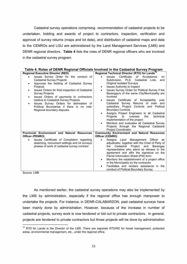
Cadastral survey operations comprising recommendation of cadastral projects to be
undertaken, bidding and awards of project to contractors, inspection, verification and
approval of survey returns (maps and lot data), and distribution of cadastral maps and data
to the CENROs and LGU are administered by the Land Management Services (LMS) and
DENR regional directors. Table 4 lists the roles of DENR regional officers who are involved
in the cadastral survey program.
Table 4. Roles of DENR Regional Officials Involved in the Cadastral Survey Program Regional Executive Director (RED)
• Issues Survey Order for the conduct of Cadastral Survey Projects
• Approves the bidding of Cadastral Survey Projects
• Issues Orders for final inspection of Cadastral Survey Projects
• Issues Orders of payments to contractors relative to Cadastral Survey Projects
• Issues Survey Orders for delineation of Political Boundaries if there is no Inter Regional boundary disputes
Regional Technical Director (RTD) for Lands19
• Issues Certificate of Acceptance on Subdivision, PLS, Cadastral Lots, and Original Isolated Surveys
• Issues Authority to Inspect
• Issues Survey Order for Political Survey if the Barangay/s of the same City/Municipality are involved
• Issues Certificate of Acceptability over Cadastral Survey Returns of main and subsidiary Project Controls and Political Boundary Controls
• Assigns Project Engineers to all Cadastral Projects to oversee the technical implementation of the project
• Monitors and evaluates all Cadastral Survey Projects through the Regional Cadastral Project Coordinator
Provincial Environment and Natural Resources Officer (PENRO)
• Issues Certificate of Completion regarding sketching, monument settings and lot surveys phases of work of cadastral survey contract
Community Environment and Natural Resources Officer (CENRO)
• Assigns Land Management Officer as adjudicator, together with the Chief of Party of the Cadastral Project and Barangay representative who stand as witness to the agreement and affix the signature on the Parcel Information Sheet (PIS) form
• Monitors the establishment of a project office in the Municipality by the contractor
• Facilitates and renders assistance in the conduct of Political Boundary Survey
Source: LMB
As mentioned earlier, the cadastral survey operations may also be implemented by
the LMS by administration, especially if the regional office has enough manpower to
undertake the projects. For instance, in DENR-CALABARZON, past cadastral surveys have
been mainly done by administration. However, because of the increase in number of
cadastral projects, survey work is now tendered or bid out to private contractors. In general,
projects are tendered to private contractors but those projects will be done by administration
19
RTD for Lands is the Director of the LMS. There are separate RTD/RD for forest management, protected
areas, environmental management, etc., under the regional office.

16
either when there are no bidders or biddings/re-biddings have been unsuccessful. In the
latter case, the regional office should have enough manpower to do the survey.
The Provincial Environment and Natural Resources Office (PENRO) and Community
Environment and Natural Resources Office (CENRO) are also involved in the survey
operations. The PENROs and CENROs are highly involved the information drive, ground
verification activities, and in helping resolve cases of land boundary disputes.
A crucial part of the survey operations is the information drive where the municipal
government, barangay officials as well as the townspeople are informed about the conduct
of a cadastral survey. This part of the survey operations is crucial especially when political
boundaries are involved. For example, for this type of survey, the original lot titles held by
residents may have to be presented as input to the information base and analysis to be done
by the private contractors (survey team). The information drive is primarily done by the
private contractors with CENRO staff providing assistance given their familiarity with the
area (barangay or municipality. The Regional Office/LMS, on the other hand, renders
assistance to the private contractors, for instance, in setting up meetings with the local
government officials of the area where the survey will be conducted. Typically, a pre-survey
conference to discuss the purpose and mechanics of the survey is done. During the conduct
of the survey itself, a Project Engineer is assigned by the Regional Office/LMS to monitor the
implementation of the project. The resident Project Engineers are trained and are also
assigned to the different projects to ensure that the survey contractors comply with the
requirements and specifications contained in the DENR Manual on Land Surveys.
Inspection and verification are also a critical part of the survey operations in relation
to timely approval or completion of the cadastral projects. These two activities involve
ground work/field work that is done by the Field Network Survey Party composed of staff,
especially Geodetic Engineers, from the DENR Regional Office.
As for the duration of major activities, we gathered from an interview at the DENR-
CALABARZON that the process of tendering bids to awarding of a project takes about one
month. When a bidding fails a subsequent re-bidding would likewise take another month.
However, once there is a successful bid and an award is given to the private contractor, it is
possible to issue a Survey Order in one day.
The duration of the survey itself depends on the extensiveness of the survey area,
e.g., how many hectares, and other factors but on the average, Category A or a full cadastral

17
survey could take 1 to 2 years to finish; Category B or political boundary survey would take 6
months to 1 year, especially if the affected LGU or LGUs cooperate in the conduct of the
survey. Otherwise, non-cooperation by affected LGUs will unnecessarily delay the survey.
It takes 6 months to 1 year to do a Category C or lot survey.
Using LMB data on duration of projects (Table 5), we find that Category A survey
done by private contractors indeed takes over a year. A survey of Category B usually
exceeds 6 months while Category C will need more than 8 months to complete. The figures
in Table 5 also indicate that a private contractor is able to accomplish an average of 44.2
hectares per day for a Category A survey, 122.6 hectares per day for Category B, and 21.7
hectares per day for Category C survey. These findings show that Category B has the
shortest project duration of the three survey categories; at the same time, it shows the
highest accomplishment (surveyed area) per day.
Table 5. Project duration surveys done by private contractors, 2007-2010
Category A Category B Category C
Est. area (ha) Ave. no. of
days Ave. area
(ha) Ave. no. of
days Ave. area
(ha) Ave. no. of days
Ave. area (ha)
1,000 or less 143.5 704.9 115.5 523.6
1,001-2,000 245.0 1,371.0 185.7 1,363.2
2,001-4,000 303.4 3,051.8 307.9 2,741.0
4,001-6,000 297.5 5,284.4 155.5 5,488.2
6,001-10,000 356.5 7,000.1 196.0 8,567.4
10,001-20,000 404.0 14,980.7 238.1 15,150.6 176.0 10,741.0
20,001-50,000 400.0 34,294.5 239.2 28,038.5
over 50,000 429.0 119,320.0 140.0 66,578.4 330.0 92,060.0
All (weighted ave.) 312.0 13,798.7 212.2 26,025.5 199.0 4,325.4 Source: Authors’ calculations based on LMB data as of March 2012
Inspection, verification and approval of certain phases of work in the project (e.g.
main and subsidiary controls, political boundary), which are done by the Regional Office,
would take 2 to 3 weeks, on average. But the final Inspection, verification and approval for
one cadastral lot (generally, one municipality) would take 2 months, on average.
A cadastral survey done by administration will take a shorter period of time to
conduct because this excludes the time-consuming process of bidding, ground inspection,
and evaluation. However, successful undertaking of cadastral projects by the Regional
Office under a ‘by administration’ approach would depend on the quantity and quality of

18
personnel available in the DENR Regional Office including the availability of sufficient funds
for field expenses. We do not have information on the number of geodetic engineers and
support staff each DENR regional office has. DBM has this information, which is necessary
and useful in evaluating the feasibility of DENR requests for approval and funding of
proposed cadastral projects to be done ‘by administration’.
Having reviewed the process and procedures of a typical cadastral survey, the
accomplishments, and status of the cadastral survey program, we then look at issues that
affect the implementation and completion of cadastral projects.
B. Implementation Issues: Causes of Delay
The immediate concern regarding the cadastral survey program is its slow progress
or the delay in the completion of cadastral projects. We discuss the causes of delay in
implementation.
(i) Failed Bidding and Slow Procurement
Available data suggest that there is slow procurement for cadastral projects launched
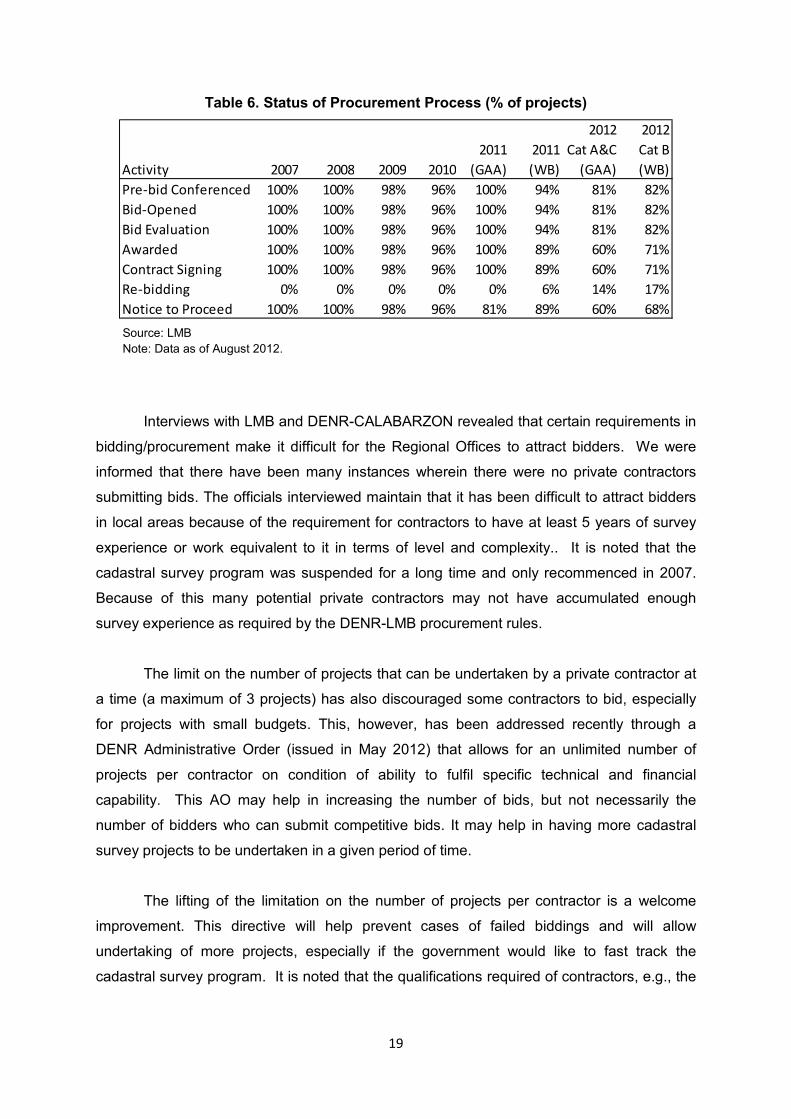
in 2011 and 2012. Table 6 indicates that only 68 percent of WB-funded projects and 60
percent of government funded (GAA) projects in 2012 have been given the notice to
proceed. It also shows that 11 percent of WB-funded and 19 percent of GAA-funded projects
listed in 2011 were not given the notice to proceed. On another note, a few projects (2% to
4%) in 2009 and 2010 did not make it to the bidding stage and were not subject to re-
bidding.
Table 6 also shows the proportion of WB-funded projects that had to be re-bid: 6 percent of
2011 projects and 17 percent of 2012 projects. On the other hand, for GAA-funded projects,
14 percent of 2012 projects need rebidding, and none for 2011 projects. Furthermore, the
data suggest that for both GAA and WB funded projects, about 19 percent of 2012 projects
have failed to reach the pre-bid conference stage.
19
Table 6. Status of Procurement Process (% of projects)
Activity 2007 2008 2009 2010
2011
(GAA)
2011
(WB)
2012
Cat A&C
(GAA)
2012
Cat B
(WB)
Pre-bid Conferenced 100% 100% 98% 96% 100% 94% 81% 82%
Bid-Opened 100% 100% 98% 96% 100% 94% 81% 82%
Bid Evaluation 100% 100% 98% 96% 100% 94% 81% 82%
Awarded 100% 100% 98% 96% 100% 89% 60% 71%
Contract Signing 100% 100% 98% 96% 100% 89% 60% 71%
Re-bidding 0% 0% 0% 0% 0% 6% 14% 17%
Notice to Proceed 100% 100% 98% 96% 81% 89% 60% 68%
Source: LMB
Note: Data as of August 2012.
Interviews with LMB and DENR-CALABARZON revealed that certain requirements in
bidding/procurement make it difficult for the Regional Offices to attract bidders. We were
informed that there have been many instances wherein there were no private contractors
submitting bids. The officials interviewed maintain that it has been difficult to attract bidders
in local areas because of the requirement for contractors to have at least 5 years of survey
experience or work equivalent to it in terms of level and complexity.. It is noted that the
cadastral survey program was suspended for a long time and only recommenced in 2007.
Because of this many potential private contractors may not have accumulated enough
survey experience as required by the DENR-LMB procurement rules.
The limit on the number of projects that can be undertaken by a private contractor at
a time (a maximum of 3 projects) has also discouraged some contractors to bid, especially
for projects with small budgets. This, however, has been addressed recently through a
DENR Administrative Order (issued in May 2012) that allows for an unlimited number of
projects per contractor on condition of ability to fulfil specific technical and financial
capability. This AO may help in increasing the number of bids, but not necessarily the
number of bidders who can submit competitive bids. It may help in having more cadastral
survey projects to be undertaken in a given period of time.
The lifting of the limitation on the number of projects per contractor is a welcome
improvement. This directive will help prevent cases of failed biddings and will allow
undertaking of more projects, especially if the government would like to fast track the
cadastral survey program. It is noted that the qualifications required of contractors, e.g., the

20
minimum number of years of survey experience or equivalent level of work required of the
contractor should be maintained to ensure quality outputs.
One reason for the slow procurement in WB-funded projects is a guideline requiring
the DENR Regional Office to submit bid documents to the World Bank (WB) resident mission
in Manila for evaluation and application for a No Objection Letter (NOL). Under this
requirement, bid documents are first submitted to the Foreign-Assisted and Special Projects
Office of the DENR (FASPO) for an initial evaluation, which are then forwarded to the WB for
a final evaluation and approval. A cadastral survey project can only proceed upon receipt of
the NOL from the WB by the DENR Regional Office. It was pointed out during the interview
that acquiring the NOL from the WB adds as much as a month’s delay to the procurement
process. Considering the numerous proposals to do a cadastral survey, the tedious two-
step process constrains the efficiency of project implementation. The NOL is a requirement
of the donor to ensure that the borrowed funds will be used for the intended purpose and
that the winning bidder is qualified to do the job.
There is a need to review and streamline the process of securing approval for the
winning bidder to proceed without sacrificing transparency and good governance. The
DENR and WB should coordinate and agree on how improvements in guidelines and
procedures may be done.
(ii) Dispute Over Boundaries
Based on interviews with the LMB and DENR-CALABARZON, conflicts in boundaries
– political or not – do not necessarily lead to a suspension of the conduct of the cadastral
survey. If a dispute among LGUs concerning political boundary issues is not settled, or a
dispute between residents cannot be resolved even with the assistance of the CENRO, the
commonly claimed or disputed area is reflected in the cadastral map. The cadastral survey
of the whole area including the disputed portions will continue, meaning that the DENR will
not wait for the dispute to be settled before conducting or proceeding with the cadastral
survey.
A significant delay in the cadastral survey happens in the establishment of political
boundaries when a LGU concerned disallows the conduct of the cadastral survey because of
disagreement with an adjacent municipality. According to the interviews, this was one major
factor behind the delay in the implementation of projects, especially the conduct of surveys

21
by the private contractors under Category B (political boundary survey).20 The political
boundary survey normally will take 6 months to 1 year to finish but because of the delay
arising from a dispute among the affected LGUs the survey may take a year or more.
The cooperation of the LGUs that are subject to cadastral survey is crucial in
completing the cadastral projects, especially in establishing political boundaries. A
memorandum of understanding among the Secretaries of the DILG, DENR, and DBM
respectively and the different leagues of local governments will be useful in addressing
various local issues impeding the efficient conduct of cadastral surveys. At present, a
memorandum of agreement between DENR and DILG is said to have been drafted but is yet
to be signed.
(iii) Peace and Order Situation
Another cause of delay in the conduct of a survey is the peace and order condition in
a locality. In this case, it is possible that the interruption of survey operations may even be
indefinite especially in areas that have high security risks. There may not even be private
contractors willing to bid for survey projects in such conflicted areas.
(iv) Volume of Projects Currently under Office Verification
In the earlier discussion on status of cadastral projects, it was found that many
projects from 2007-2011 are still under office verification, i.e. survey returns submitted by
private contractors are for inspection and verification by the DENR Regional Office. The lack
of manpower in the DENR Regional Office (CALABARZON) is constraining the efficiency of
the ground verification process. The Chief of the Survey Division of DENR-CALABARZON
pointed out that given the limited number of technical personnel there could be more
significant delays especially now with the increase in number of cadastral survey projects.
This situation may be generally true across DENR Regional Offices but we were not able to
obtain this information from the DENR Head Office. It will be important to find out the ratio of
technical personnel, say geodetic engineers to the magnitude of the survey work to be done
per Regional Office. The DENR Head Office can easily compute this ratio.
Data on status of the 2007-2011 cadastral projects by region in Table 7 indicate that
as of August 2012, about half of the projects launched in 2009 and 2010 are still undergoing
20
Source: Chief of Surveys Division in DENR-CALABARZON.

22
office verification. These are years when the number of cadastral projects doubled that of
2007 and 2008.
The data also suggest that regions with 10 projects or less in 2007-2011 seem to
have better accomplishments. They also have a lesser number of projects under verification
and have more approved surveys. The problem is that having fewer projects would prolong
and delay overall the completion of cadastral surveys in those regions.
On the other hand, in regions with more than 10 projects in 2007-2011 such as CAR
with 21 projects, Region VI with 20 projects and Region X with 22 projects, accomplishment
has been low. Region I with 12 projects is an exception because it has relatively good
accomplishments. These regions have the most number of projects under office verification
and the least number of approved surveys.
The absorptive capacity of the regions to manage cadastral survey projects is an
issue, especially taking into consideration that the number of projects has significantly
increased from 79 projects in 2011 to 354 projects in 2012. It will be important for DENR and
DBM to determine the optimal distribution of geodetic engineers and support staff among the
regions because lack of skilled manpower appears as a significant reason behind the delays
and other problems encountered during implementation of the cadastral surveys. An attempt
to remedy the situation is through the hiring of contractual staff. For 2011-2012, a total of 54
Geodetic Engineers and 18 Mathematician Aides were hired under contractual service to
supplement the workforce of the cadastral survey projects in the regions.21 An assessment
should be done in order to determine whether the additional personnel expedited the
completion of delayed cadastral projects and addressed other implementation issues in the
regions where they have been assigned.
It is noted that the lack of cooperation of some LGUs is also part of the problem.
Fieldwork done in the survey areas, such as the actual conduct of the survey and ground
verification, requires official permission from the LGU officials. An uncooperative or
inefficient LGU can impose a tremendous delay in the ground verification process.
Before a cadastral project is launched, the Regional LMS writes a letter to the
LGU/Mayor of the municipality informing them that a cadastral survey will be conducted in
their area. It is the private contractor that brings this letter to the LGU. The consent of the
21
From DENR, “Comments on the Draft Report Submitted by PIDS Consultants on the ZBB Study Entitled
Assessment of Efficiency and Effectiveness of the Cadastral Survey Program of DENR”, September 20, 2012.

23
LGU signals the start of coordination for the launching of the cadastral project. The Regional
LMS sets a meeting with the LGU to formally discuss the cadastral project and its launch
and asks for cooperation and assistance as may be needed during the conduct of the
survey.
Our review of accomplishments showed that the backlog of projects to be verified
and validated is a serious problem. DENR instinctively will reach out for the obvious
solution: for the inspections and verifications to be completed, additional personnel e.g.
Geodetic Engineers may be needed. However, this does not necessarily mean hiring
additional government personnel. There is scope for public-private partnership (PPP) as a
mechanism to address the backlog and to expedite the conduct of future cadastral projects.
The private sector has the incentive to secure the right number of personnel needed and the
logistics required, etc, and to finish the job on time if not ahead of time. The participation of
the private sector can also mean hiring them as technical advisors. However, it remains
LMB’s responsibility to supervise and manage those technical advisors.
Adopting a PPP approach does not necessarily mean that cadastral surveys should
not be done “by administration” at all as there may be cases where such an approach is
more applicable and justified. For instance, there may be instances where there is difficulty
in attracting bids from private contractors due perhaps to problems with the peace and order
condition or extreme difficulties in the planned survey areas. It may be advantageous to
have some flexibility in this regard.

24
Table 7. Status of 2007-2011 Cadastral Projects by Region, as of August 2012
2007 2008 2009 2010 2011
REGN
Total no. of
projects 2007-
2011)
No. of
proj
Ongoing:
Fieldwork
Ongoing:
Office
Verif
Approved
Survey
No. of
proj
Ongoing:
Fieldwork
Ongoing:
Office
Verif
Approved
Survey
No. of
proj
Ongoing:
Fieldwork
Ongoing:
Office
Verif
Approved
Survey
No. of
proj
Ongoing:
Fieldwork
Ongoing:
Office
Verif
Approved
Survey
No. of
proj
Ongoing:
Fieldwork
Ongoing:
Office
Verif
Approved
Survey
CAR 21 9 8 1 1 1 5 1 1 3 3 2 1 3 1 2
NCR 8 5 1 4 1 1 2 1
Region I 12 4 4 4 1 3 3 3 1 1
Region II 15 1 1 1 1 4 4 3 3 2 6 4 1
Region III 15 6 6 2 2 1 1 2 4 4
Region 4-A 22 3 1 2 1 1 3 1 2 1 1 13 4 9
Region 4-B 6 1 1 1 1 4 1
Region V 10 1 1 1 1 5 4 1 3 3
Region VI 20 3 2 1 7 6 1 7 2 5 1 3 2
Region VII 24 3 1 2 5 2 3 1 1 6 1 4 9 9
Region VIII 14 1 1 1 1 3 2 1 6 6 3 3
Region IX 12 1 1 2 2 3 1 2 6 3 3
Region X 22 11 5 6 5 5 6 5
Region XI 12 5 2 3 4 3 1 3 2
Region XII 17 1 1 3 3 5 2 3 3 2 1 5 2 2
Region XIII 18 1 1 2 2 7 2 2 3 8 5 3
Total 248 25 1 11 13 25 1 9 15 64 13 27 22 55 15 34 6 79 50 17 3
Source: LMB data as of August 2012

25
C. Overlap of Survey and Titling Activities with other Government Agencies
Given that two other government agencies conduct survey and titling activities aside
from DENR-LMB/LMS, namely, the Land Registration Authority (LRA) and the National
Commission for Indigenous Peoples (NCIP), the issue of whether or not there is an overlap
in the conduct of such activities arises.
An appreciation of the different mandates of the concerned agencies indicates that
the surveying and titling functions and the expected outputs of the 3 agencies are distinct
and delineated, implying that there is no apparent functional overlap as shown in Table 8. It
seems that for as long as these functions are strictly followed in practice, there would not be
any overlap in discharging their respective functions. This also highlights the importance of
research and sharing of information as far as land records are concerned. Awareness of the
status, classification of an area, and the purpose of the survey lessens the probability of an
overlap happening during actual surveying or titling activities.
Table 8. Surveying and Titling Activities of Selected Agencies
Agency Surveying and Titling Functions Output
DENR-LMB/LMS Cadastral survey of public/A&D lands – for purposes of titling, taxation, land use planning; patent titling; Cadastral survey also covers forestlands
Cadastral map and lot data, free patent
LRA Issue subsequent or transfer certificates of title (judicial or admin)
Subsequent or transfer certificates of title (judicial, decreed or admin)
NCIP Issue certificate/title for ancestral land/domain
Titles for ancestral domain/land
It is noted that the three agencies (LMB, LRA, and NCIP) all operate in the identified
alienable and disposable (A&D) lands. DENR-LMB is concerned with cadastral survey,
which includes patent titling. LMB’s patent titling function may be a source of overlap with
LRA in as much as the latter is (mainly) concerned with land titling although clearly LRA
deals with transfer certificates of title, not patent titles. In the case of NCIP it is concerned
with issuing titles over ancestral domain lands, which lands may also have been or are also
currently subject to petitions for patent titling by long-time residents, not necessarily
belonging to minority groups, e.g., tribes. The upshot of this observation is that these three
agencies will have to properly coordinate their activities, share land information, properly

26
train their staff members, and install/use modern technologies, e.g., computerization of land
information, use of satellite information and others, to avoid any overlap.
V. An Estimate of the Number of Years and Costs for Completion of the Cadastral Survey Program
This section attempts to estimate the number of years needed to finish and complete
the cadastral survey program and the project cost required. The LMB has data on the status
of the cadastral survey program. However, there is no exact figure as to how many areas still
remains to be surveyed. Table 9 presents the status of the cadastral survey program: (a)
areas not yet surveyed, (b) partially surveyed areas, (c) surveys in-progress and (d)
approved surveys. These are estimated figures. The table also presents the remaining areas
that need to be surveyed based on the status of the program as of CY2010. For the
estimation of the cost for the completion of the survey of remaining areas, we made a few
simple assumptions because some information that would be important in doing our
estimations are not available. For instance, interviews at the Geodetic Surveys Division of
LMB indicated that the partially surveyed projects may need a Category B survey (political
boundary). However, information as to the number or proportion of projects that need
Category B is not available. The interviews also indicated that some of the in-progress
projects may be partial and not full cadastral surveys, and so may require additional surveys
later on. There is likewise no information on the number or the proportion of such projects.
Given that some important pieces of information are not available, we made the following
assumptions in estimating the remaining area:
(1) Un-surveyed areas will undergo a full cadastre survey (Category A).
(2) Partially-surveyed areas that are covered by Public Land Subdivision Surveys (Pls) and
Group Settlement Surveys (Gss) will undergo a Category B (political boundary survey). We
found from our interview at LMB that partially surveyed areas may require a political
boundary survey.
(3) Some of the projects under “In-progress” may be partial surveys, that is, not covering the
whole municipality according to our interviews at LMB. Thus, we assume that half of those
projects may require Category A survey.
(4) Areas with approved surveys will not be re-surveyed.
(5) Category A projects will take at most 2 years to finish from start (bidding) to finish
(verification process and then approval), while Category B will take about 1 year to finish.

27
These assumptions are based on LMB data and interview with CALABARZON Regional
Office/LMS.
(6) Project costs are as follows, based on LMB’s bills of quantity as of March 2012: PHP
3,003.05 per hectare for Category A; PHP 326.05 for Category B; PHP 2,677 for Category
C.22 In computing the budget for the survey, we also present estimates adjusted for inflation
of 5% (average inflation in the last 10 years, using BSP data).
(7) The cadastral survey projects will be done by private contractors.
Using LMB data made available to us, we estimated that the remaining area that still
needs to be covered by the cadastral survey is around 10,902,545 hectares (Table 9). In
particular, there are approximately 1.028 million hectares of land that have not been
subjected to the cadastral survey. We estimated about 3.156 million hectares of in-progress
cadastral projects and about 6.718 million hectares of partially-surveyed areas that need to
be surveyed based on the assumptions given above.
Table 9. Summary of Cadastral Status for CY2010
Program Status as of CY2010:
Estimated Balance as of CY2010:
Municipalities Cities Total Land Area
(ha) Land Area
(ha)
Approved Survey 780 104 884 16,898,210 ----
Partially surveyed 294 12 306 6,718,043 6,718,043
In-Progress 263 18 281 6,312,932 3,156,466
Un-surveyed 45 - 45 1,028,036 1,028,036
Total 1,382 134 1,516 30,957,221 10,902,545 Source: Geodetic Surveys Division, LMB and authors’ calculations Notes: Excluding ARMM; “Program Status as of CY2010” refers to the accomplishment of the cadastral survey program by project status; “Estimated Balance as of 2010” refers to the land area that still needs to be subjected to cadastral survey, as calculated by the authors based on the assumptions mentioned above.
Given the assumptions above and the data available in LMB, we present estimates of
the target project coverage and project cost under two scenarios: completion of the cadastral
survey program within either a five-year or ten-year time frame.
(1) Completion of cadastral survey projects in 5 years
Given the status of the cadastral program as of 2010, the estimated area that
remains to be covered by cadastral survey is approximately 10.902 million hectares. If the
22
This ‘Bills of Quantity’ has been used by LMB since 2009 and needs updating.

28
program is to be finished in 5 years, the program should target an annual average of
2,725,636.25 hectares of cadastral projects within a four year period, assuming that there is
a year of delay before the survey is actually completed.
The cost entailed by such targets is an annual average of PHP3.689 billion in a span
of 5 years inclusive of a year of delay. Hence, we estimate a total cost of PHP14.757 billion.
This estimate used the project costing that has been implemented by LMB since 2009, i.e.
PHP 3,003.05 per hectare for Category A; PHP326.05 for Category B; PHP 2,677 for
Category C. Adjusting for a 5% yearly inflation, total project cost will be around PHP16.696
billion. The project costs per year under different project cost assumptions are indicated in
Table 10.
Table 10. Cost of Completion of Cadastral Survey Program in 5 years
Balance as of
2010 (ha.) Year 1 Year 2 Year 3 Year 4 Year 5 Total
Coverage in hectares 10,902,545 2,725,636 2,725,636 2,725,636 2,725,636 (spill-over) 10,902,545
Project Cost 1 --- 3,689,168,304 3,689,168,304 3,689,168,304 3,689,168,304 --- 14,756,673,215
Project Cost 2 --- 3,689,168,304 3,689,168,304 3,689,168,304 3,873,626,719 --- 14,941,131,630
Project Cost 3 --- 3,873,626,719 4,067,308,055 4,270,673,458 4,484,207,131 --- 16,695,815,362
Source: Authors’ calculations using data and information from LMB Note: Project Cost 1 uses current Bill of Quantity (project costing) used by LMB since 2009; Project Cost 2 shows a one-time adjustment for inflation of 5%; Project Cost 3 adjusts for yearly inflation of 5%. The inflation rate of 5% was used as this was the average rate in the last ten years-BSP data. All costs in pesos.
(2) Completion of cadastral survey projects in 10 years
Using the same 10.902 million hectares remaining to be surveyed as of 2010, to
finish the program in 10 years inclusive of a year’s delay, the government should target an
annual average of 1,211,394 hectares of cadastral projects in 9 years. This gives the
projects launched in the 9th year some allowance of time to complete in case they will not be
finished during that year, considering also that Category A surveys take up to 2 years to
complete.
This set up will entail an annual average project cost of about PHP1.640 billion and
a total of around PHP14.757 billion, using the current project costing (Bill of Quantity) of the
LMB. As in the previous scenario, if we adjust for inflation of 5% every 5 years, total budget
will then be about PHP15.335 billion (Table 11); while, a yearly 5% inflation will give a total
budget of around PHP18.983 billion.

29
Table 11. Cost of Completion of Cadastral Survey Program in 10 years
Balance as of
2010 Year 1 Year 2 Year 3 Year 4 Year 5
Coverage in hectares 10,902,545 1,211,394 1,211,394 1,211,394 1,211,394 1,211,394
Project Cost 1 --- 1,639,630,357 1,639,630,357 1,639,630,357 1,639,630,357 1,639,630,357
Project Cost 2 --- 1,639,630,357 1,639,630,357 1,639,630,357 1,721,611,875 1,721,611,875
Project Cost 3 --- 1,721,611,875 1,807,692,469 1,898,077,092 1,992,980,947 2,092,629,994
(cont'd) Year 6 Year 7 Year 8 Year 9 Year 10 Total
Coverage in hectares --- 1,211,394 1,211,394 1,211,394 1,211,394 spill-over 10,902,545
Project Cost 1 --- 1,639,630,357 1,639,630,357 1,639,630,357 1,639,630,357 --- 14,756,673,215
Project Cost 2 --- 1,721,611,875 1,721,611,875 1,721,611,875 1,807,692,469 --- 15,334,642,916
Project Cost 3 --- 2,197,261,494 2,307,124,569 2,422,480,797 2,543,604,837 --- 18,983,464,074 Source: Authors’ calculations using data and information from LMB Note: Project Cost 1 uses current Bill of Quantity (project costing) used by LMB since 2009; Project Cost 2 adjusts for inflation of 5% in 2014 and another 5% in 2019; Project 3 adjusts for yearly inflation of 5%. Inflation rate of 5% was used as this was the average rate in the last ten years-BSP data. All costs in pesos.
The two scenarios presented also assume timely accomplishment of all survey
activities by the surveyor, and also timely verification and approval by the Regional
Office/LMS. The bottleneck of the program since 2007 has largely been the office and field
verification processes. To address this constraint, there should be adequate and well-trained
manpower in the Regional Office/LMS to verify and approve surveys without delay. This
need is felt most especially in regions that have low physical accomplishments.
VI. Summary and Recommendations
This paper reviewed the accomplishments of the cadastral survey projects
undertaken in the government’s cadastral survey program. It also determined the causes of
the slow progress of the program implementation based on information and data made
available by the DENR. It was found that the causes of implementation delays include the
following:
(a) tedious procurement process due to several factors, including some procurement
guidelines;
(b) frequency of failed bidding arising from defects in procedure and documentation;
(c) unresolved dispute over boundaries especially when it is LGUs that are in
disagreement;
(d) slow ground verification process due to lack of skilled manpower, e.g., geodetic
engineers, and the backlog in the huge volume of projects currently under
verification;

30
(e) the peace and order situation in the area subject to cadastral survey, and
(f) the lack of cooperation of some LGUs;
(g) inaccurate and dated database that prevents efficient planning and programming
of resources for the surveys.
Based on the status of the cadastral program as of CY2010 and some assumptions,
we estimated that the remaining area that still needed to be surveyed is approximately
10.902 million hectares.
Estimates of the time and cost of conducting the remaining cadastral surveys were
presented in two scenarios. To complete the survey of the remaining areas in 5 years, the
government needs about PHP14.757 billion based on current Bill of Quantity used by LMB,
without adjustment to inflation; or about PHP14.941 billion under a one-time adjustment of
5%; or about PHP16.696 billion if adjusted yearly for 5% inflation.
On the other hand, completing the program in 10 years will entail cost amounting to
about PHP14.757 billion, using the current Bill of Quantity; or around PHP15.335 billion if
adjusted for 5% inflation every 5 years; or about PHP18.983 billion if adjusted yearly for 5%
inflation.23
Given these findings, the following recommendations to improve the program are
presented:
• LMB should allocate time and budget to improve, cleanse, monitor, and update
its land database. This should be done in coordination with NAMRIA, LRA, and
NCIP, which are the associated land agencies of the government. The DENR-LMB
should also check and organize available records for sharing information with its
Regional Offices.
• Before approving the funding of proposed cadastral projects, DBM should
require DENR-LMB to (a) submit accurate data and information on
accomplishments of the previous year’s cadastral survey projects, and on
remaining areas to be surveyed, and (b) expedite the conduct of the delayed
but previously approved cadastral projects. There is a serious back log in
cadastral surveys and this has to be resolved prior to accepting any request for
23
These estimates were based on available crude data and information and some simplifying assumptions. More
refined or accurate data would have provided better estimates. When such more accurate or better data become available, the method used in the estimation here may be one option to estimate the remaining cost and time to complete the cadastral survey program.

31
funding of new cadastral projects. Addressing the back log in a resolute manner will
also give LMB the necessary information and experience on how to manage and
implement future requests for funding cadastral projects.
• DBM in collaboration with DENR should provide both a hard budget constraint
and indicate the time period to complete the planned cadastral survey projects
with specific performance indicators to justify additional budgets.
• DENR in collaboration with other agencies such as NAMRIA, LRA should
install a modern project monitoring system that links information and data
from the municipal, city, and provincial level to the regional office, which in
turn is linked to a central database at the LMB, with data updated and validated
in a regular and timely manner.
• DENR should formulate and implement specific guidelines to finish the
backlog and accelerate the completion of the survey of remaining areas.
• DBM and DENR should agree on a joint monitoring and field verification
process to check on the progress of the cadastral survey program. DBM can
perform random and unannounced checks in this regard. This would be one
way of motivating the DENR regional offices to efficiently implement the
program.
• DENR and DBM could consider public-private partnership (PPP) as a
mechanism to address the backlog in cadastral surveys and to expedite the
conduct of future cadastral projects.
• DENR and the main donor, the World Bank, should revisit the procurement
guidelines in order to speed up the issuance of the NOL.
• DENR, DILG, the relevant leagues of local governments, and the specific LGU
or LGUs concerned should sign a memorandum of understanding to expedite
the survey of disputed areas in the LGU/LGUs concerned. DENR Regional
Offices should give a feedback to the Head Office on instances of non-
cooperative behaviour so that appropriate intervention to address problematic

32
LGUs may be done at level of the DILG and DENR secretaries. The oversight
agencies (DENR and DILG) should monitor compliance with the MOU.
• DBM and DENR should jointly conduct field visits to collect more and better
information and verify the findings of this paper. Because of budget and time
constraints it was not possible for the study team to collect a sufficient quantity of
data on the subject.

33
References
Department of Environment and Natural Resources (DENR) Administrative Order 2012-03.
Amendment of DAO 2011-09, “Supplementary Provisions to DAO No. 2008-14, Re
guidelines on the Conduct of Bidding and Awarding of Cadastral Survey Project
Contracts Pursuant to RA 9184.
DENR Memorandum Circular No. 2010-13. Adoption of the Manual of Land Survey
Procedures.
DENR. Comments on the Draft Report Submitted by PIDS Consultants on the ZBB Study
Entitled Assessment of Efficiency and Effectiveness of the Cadastral Survey Program of
DENR. September 20, 2012.
DENR – Land Management Bureau (LMB). A to Z of a Cadastral Survey Project.
DENR-LMB website. http://www.lmb.gov.ph.
National Mapping and Resource Information Authority (NAMRIA) website.
http://www.namria.gov.ph