Embed Size (px)
Citation preview
Final Lower Duwamish River NRDA Restoration Plan and Programmatic
Environmental Impact Statement
June 2013
Prepared by the National Oceanic and Atmospheric Administration on behalf of the Lower Duwamish River Natural Resource Damage Assessment Trustee Council

Lower Duwamish River NRDA Restoration Plan and Programmatic Final Environmental Impact Statement
Project Locations: Duwamish River and Green River, King County, Washington
Lead federal agencies for the Restoration Plan and the PEIS:
National Oceanic and Atmospheric Administration (NOAA) and U.S. Department of the Interior, Fish and Wildlife Service (DOI/FWS)
Lead Administrative Trustee: NOAA Damage Assessment and Restoration Center Northwest. Attn: Rebecca Hoff, 206-526-6276, [email protected]
Cooperating agencies and tribes: Washington Department of Ecology (as lead state Trustee) and Washington Department of Fish and Wildlife, Suquamish Tribe, Muckleshoot Indian Tribe, U.S. Army Corps of Engineers, and U.S. Environmental Protection Agency
Comments/Contact Person: Rebecca Hoff, NOAA DARC NW, 7600 Sand Point Way NE, Seattle, WA 98115, Email: [email protected] Comments must be received no later than 30 calendar days after the notice of availability for the Final PEIS is published in the Federal Register.
Administrative Record: This Restoration Plan/Programmatic Environmental Impact Statement and its supporting documentation may be reviewed by contacting the case records manager Rebecca Hoff at 206-526-6276 or [email protected].
ABSTRACT Hazardous substance releases into the Lower Duwamish River (LDR) resulted in the contamination of the sediments and injuries to natural resources. The Elliott Bay Trustee Council (Trustees) is developing the Lower Duwamish River Natural Resource Damage Assessment (LDR/NRDA) to determine the extent of injuries to natural resources resulting from these releases. Natural resources include fish, shellfish, wildlife, sediments, and water quality, and the services they provide. Trustees are also determining how to restore injured natural resources and lost resource services. The Restoration Plan, which is also a Programmatic Environmental Impact Statement (PEIS) will guide implementation of LDR/NRDA restoration activities. The PEIS analyzes the environmental impacts of the alternatives considered by the Trustees to restore, replace, rehabilitate, and/or acquire the equivalent of the injured natural resources and their services. The Trustees evaluated three alternatives: the No-Action Alternative, which is required to be included in the analysis; the Species-Specific Restoration Alternative; and the Integrated Habitat Restoration Alternative. The Trustees’ preferred alternative is Integrated Habitat Restoration, which is a comprehensive plan based on restoration of key habitats that, together, will benefit the range of different resources injured by releases of hazardous substances in the LDR. In addition, the Trustees have included a detailed description of the methodology considered for use in a settlement-based approach to injury assessment for the Lower Duwamish River. A draft RP/PEIS was made available for public review on May 22, 2009, with the comment period ending on July 28, 2009. In response to comments received on that draft, the Trustees added more detail about the injury assessment and restoration valuation methodology used in the LDR/NRDA, and made some other minor changes to address other comments. The Trustees released the Supplement to the draft RP/PEIS for additional review and comment on July 27, 2012, with the comment period ending on October 10, 2012. This Final PEIS was developed after consideration of all comments received.
2

EXECUTIVE SUMMARY
The Elliott Bay Trustee Council (Trustees) is developing the Lower Duwamish River Natural Resource Damage Assessment (LDR/NRDA) to determine the extent of injuries to natural resources, such as fish, shellfish, wildlife, sediments, and water quality, and the services they provide. The LDR/NRDA is being conducted pursuant to the Comprehensive Environmental Response, Compensation, and Liability Act of 1980, the Oil Pollution Act of 1990, and other applicable laws. Concurrent with the damage assessment process, the Trustees are conducting restoration planning to determine the best approach to restoring, rehabilitating, replacing, and acquiring the equivalent of the injured natural resources and their associated services. To guide the restoration process, the Trustees have prepared this Restoration Plan/Programmatic Environmental Impact Statement (RP/PEIS), with the National Oceanic and Atmospheric Administration (NOAA) and the U.S. Department of the Interior, Fish and Wildlife Service (DOI/FWS) as the lead federal agencies. The cooperating agencies are the other Trustees, the U.S. Army Corps of Engineers (ACOE), and the Environmental Protection Agency (EPA).
The RP/PEIS will guide decision-making regarding the implementation of LDR/NRDA restoration activities. This plan is intended to expedite and provide a point of departure for future site-specific projects and facilitate the preparation of subsequent project-specific environmental documents through the use of “tiering.” Project-specific National Environmental Policy Act (NEPA) environmental evaluation documents will be prepared for future restoration projects and will be referenced back to (tiered from) the RP/PEIS.
The overall goal of the Restoration Plan is to restore, replace, or acquire the equivalent of those natural resources injured as the result of hazardous substance releases. The PEIS analyzes the environmental impacts of the alternatives that may be employed by the Trustees to restore, replace, rehabilitate, and/or acquire the equivalent of the injured natural resources as well as the services they would have provided but for the hazardous substance releases and oil discharges to the environment of the Lower Duwamish River. Three alternatives were evaluated in the RP/PEIS: 1) No Action, an alternative that is required to be considered, under which the Trustees would not conduct restoration actions to restore natural resources; 2) Species-Specific Restoration, under which the Trustees would develop specific restoration actions designed to benefit individual species; and 3) Integrated Habitat Restoration, under which habitat complexes would be developed to benefit, directly or indirectly, the suite of natural resources that were injured by releases of hazardous substances into the LDR. The Trustees preferred alternative is the Integrated Habitat Restoration Alternative, which is a comprehensive plan based on restoration of key habitats that, together, will benefit the range of different resources injured by releases of hazardous substances in the LDR. This alternative best meets the needs of the Trustees’ restoration goals and principles by maximizing ecological benefits for a wider range of natural resources and their associated services.
The Trustees have taken an ecosystem approach to planning for the implementation of restoration projects as part of the LDR/NRDA. Trustees established priority focus areas for restoration that fulfill CERCLA requirements (restoration with a strong nexus to the injured resources) and puts restoration in areas where habitat is scarce and essential for fish and
3

wildlife in the Lower Duwamish River. Each Habitat Focus Area (HFA) places boundaries around important target habitat features and incorporates geographic boundaries, restoration site clusters, exposure to wave energy, location, maritime uses, land uses, and development. Four HFAs are covered under this document:
• HFA1—Lower Duwamish River, extending from the northern tip of Harbor Island upstream to North Winds Weir.
• HFA2—Inner Elliott Bay Shoreline, between the Duwamish head and Port of Seattle Terminal 91.
• HFA3—Duwamish River Reach (farther upstream of the Lower Duwamish), which goes from upstream of North Winds Weir to the confluence of the Green and Black rivers.
• HFA4—Green River Reach (upstream from the Duwamish River Reach) which extends from the confluence of the Green and Black rivers to the boundary of the Lower Green River Watershed (as defined by Green/Duwamish and Central Puget Sound Water Resource Inventory Area 9 (WRIA 9)).
The Trustees’ ability to restore injured resources and the approach required varies among the HFAs. Priority will be given to projects within HFA1—Lower Duwamish River and HFA2—Inner Elliott Bay. Projects in other HFAs will be subject to minimum size and project type restrictions, and will be acceptable for NRDA settlements only if they are a component of a settlement proposal that includes restoration in HFA1.
Restoration Goals
The overall goal of the Restoration Plan is to restore, replace, or acquire the equivalent of those natural resources injured as the result of hazardous substance releases. To accomplish this goal, the Trustees will restore important habitats that support injured resources. Estuarine and riparian habitats of the LDR are a fraction of their historic acreage; this lack of habitat is believed to be a limiting factor for many natural resources and services within this system. To restore injured resources and improve the LDR’s ability to support these resources, the Trustees will consider rehabilitation, creation, and enhancement projects.
Trustees intend to restore habitats that rebuild marine and aquatic resources and services lost from contamination. Marshes and mudflats are a top priority, because of their high habitat value to the types of natural resources believed to have been injured by releases of hazardous substances in the LDR. Riparian buffers, especially those adjoining marsh habitats, are also targeted because they support wildlife, filter runoff, and provide material inputs. The restoration of mudflats, marshes, and riparian buffers, especially in integrated habitat complexes, is the primary focus of the Trustees for the NRDA process because these have been determined to have the most direct benefits to injured resources. However, Trustees will consider other project types that show clear benefits to injured natural resources.
Restoration in the LDR is constrained by commercial and industrial uses and other physical developments in the river and along the shorelines. Restoring areas of habitat within a system that has undergone such a high level of alteration and that supports numerous land use types—including industry, commercial, residential, open space, and urban infrastructure—without negatively affecting those existing uses is challenging, but there are several examples of
4
successful habitat restoration projects that have been built in the LDR without negatively impacting existing uses. Primary objectives of the Trustees for the LDR include:
1. Implement restoration with a strong nexus to the injuries caused by releases of hazardous substances in the Lower Duwamish River.
2. Provide a net gain of habitat function beyond existing conditions for injured fish and wildlife by restoring important habitat types and the physical processes that sustain them.
3. Integrate restoration strategies to increase ecosystem structure and function.
4. Preserve existing threatened functioning habitats while enhancing or creating new high-value habitats.
5. Coordinate restoration efforts with other planning and regulatory activities to maximize restoration potential.
6. Ensure that restoration sites and associated habitat functions are preserved in perpetuity.
7. Involve the public in restoration planning and implementation through education and outreach.
An initial draft RP/PEIS was made available for public review on May 22, 2009, with the comment period ending on July 28, 2009. A supplement to the RP/PEIS was available for public review from July 27, 2012, to October 10, 2012. In the supplement to the RP/PEIS, the Trustees added more detail about the injury assessment and restoration valuation methodology used in the LDR/NRDA, as requested in some of the comments received on the initial draft, and made some minor changes to address other comments.
5

Blank Page
TABLE OF CONTENTS
ABSTRACT ......................................................................................................................................... 2
EXECUTIVE SUMMARY ...................................................................................................................... 3
LIST OF TABLES ............................................................................................................................... 12
LIST OF FIGURES ............................................................................................................................. 12
LIST OF APPENDICES ....................................................................................................................... 13
ACRONYMS AND ABBREVIATIONS ................................................................................................. 13
1. PURPOSE AND NEED ................................................................................................................... 15
1.1 Introduction ................................................................................................................. 15
1.2 Purpose and Need for Action ...................................................................................... 15
1.3 Legal Mandates and Authorities ................................................................................. 16
1.4 Natural Resource Trustees .......................................................................................... 17
1.5 Differences between the Remediation Process and Natural Resource Damage Assessment ........................................................................................................... 17
1.6 Overview of the Damage Assessment Process............................................................ 19
1.6.1 Preliminary Assessment (Pre-Assessment) ................................................. 19
1.6.2 Injury Assessment/Restoration Planning .................................................... 19
1.6.3 Restoration Implementation ....................................................................... 20
1.6.4 Current Stage of Natural Resource Damage Assessment in the Lower Duwamish River ....................................................................................... 20
1.7 Restoration Goals ........................................................................................................ 21
1.8 Need for Restoration Planning .................................................................................... 22
1.8.1 Purpose of Restoration Planning ................................................................. 24
1.8.2 Benefits of Restoration Planning ................................................................. 24
7

2. INJURY ASSESSMENT METHODOLOGY ....................................................................................... 27
2.1 Introduction to Habitat Equivalency Analysis (HEA) ................................................... 27
2.2 Lower Duwamish River Habitat Equivalency Description ........................................... 28
2.2.1 Discounting .................................................................................................. 29
2.2.2 Lower Duwamish River Habitat Equivalency Model ................................... 30
2.2.3 Allocation of Liability ................................................................................... 37
2.3 Alternate Methods for Injury Assessment .................................................................. 38
3. ENVIRONMENTAL SETTING/AFFECTED ENVIRONMENT ............................................................ 41
3.1 Affected Environment ................................................................................................. 41
3.1.1 Sediment Quality ......................................................................................... 41
3.1.2 Air Quality .................................................................................................... 41
3.1.3 Water Quality .............................................................................................. 43
3.1.4 Potential Impacts of Climate Change on Proposed Restoration ................. 43
3.2 Physical Environment .................................................................................................. 45
3.3 Biological Resources .................................................................................................... 46
3.4 Socioeconomic/Cultural Resources ............................................................................. 49
4. PROGRAMMATIC NEPA REQUIREMENTS ................................................................................... 51
4.1 NEPA Requirements .................................................................................................... 51
4.2 Public Participation ...................................................................................................... 51
4.3 Administrative Record ................................................................................................. 53
5. AFFECTED PROGRAM ................................................................................................................. 55
5.1 Trust Natural Resources and Services ......................................................................... 55
5.2 Responsible Party Liability ........................................................................................... 56
6. PROPOSED ACTION: REGIONAL RESTORATION PLANNING ........................................................ 57
6.1 Description of the Preferred Alternative (Integrated Habitat Restoration) ................ 57
8
6.2 Restoration of Injured Natural Resources and Services .............................................. 57
6.3 Key Duwamish Habitats ............................................................................................... 57
6.4 General Restoration Strategy ...................................................................................... 59
6.5 Restoration Process and Objectives ............................................................................ 60
6.6 Habitat Focus Areas ..................................................................................................... 61
7. RESTORATION TYPES .................................................................................................................. 65
7.1 Desired Types of Restoration ...................................................................................... 67
7.1.1 Creation of Intertidal Mudflat ..................................................................... 68
7.1.2 Creation of Marsh........................................................................................ 68
7.1.3 Creation of Riparian Habitat ........................................................................ 69
7.1.4 Potential Restoration Construction Actions ................................................ 70
7.2 Types of Restoration Not Desired ............................................................................... 71
7.3 Restoration Project Monitoring and Performance Criteria ......................................... 71
7.3.1 Performance Criteria ................................................................................... 71
7.3.2 Adaptive Management ................................................................................ 72
7.3.3 Monitoring Parameters ............................................................................... 72
7.3.4 Reporting Requirements ............................................................................. 73
7.4 Stewardship Model ..................................................................................................... 74
8. PROJECT SELECTION ................................................................................................................... 75
8.1 Summary of Other Restoration Plans .......................................................................... 75
8.2 Selection Criteria ......................................................................................................... 76
8.3 Examples of Restoration Projects from previous settlements .................................... 77
9. RESTORATION ALTERNATIVE ANALYSIS ..................................................................................... 79
9.1 Analysis of the Alternatives for the Purposes of Restoration ..................................... 80
9.1.1 Alternative One: No Action ......................................................................... 80
9

9.1.2 Alternative Two: Species-Specific NRDA Restoration ................................. 81
9.1.3 Alternative Three: Integrated Habitat Restoration (Preferred) .................. 82
9.2 Direct, Indirect, or Cumulative Impacts of Alternatives under NEPA ......................... 84
9.2.1 Likely Impacts of the Alternatives ........................................................... 85
9.2.2 Likely Effects of the Alternatives on Public Health and Safety [40 CFR 1508.27(b)(2)]. ........................................................................................ 88
9.2.3 Unique Characteristics of the Geographic Area in Which the Alternatives Would be Implemented [40 CFR 1508.27(b)(3)]. .................................... 89
9.2.4 Controversial Aspects of the Alternatives or Their Likely Effects on the Human Environment [40 CFR 1508.27(b)(4)]. ......................................... 90
9.2.5 Degree to Which Possible Effects of Implementing the Alternatives are Highly Uncertain or Involve Unknown Risks [40 CFR 1508.27(b)(5)]. ..... 90
9.2.6 Precedential Effect of the Alternatives on Future Actions that May Significantly Affect the Human Environment [40 CFR 1508.27(b)(6)]. ... 90
9.2.7 Possible Significance of Cumulative Impacts from Implementing Restoration under These Alternatives and Similar Projects from Other Mechanisms; Potential Impacts on Connected Actions [40 CFR 1508.27(b)(7)]. ........................................................................................ 91
9.2.8 Effects of the Alternatives on National Historic Places, or Likely Impacts to Significant Cultural, Scientific, or Historic Resources [40 CFR 1508.27(b)(8)]. ........................................................................................ 93
9.2.9 Degree to Which the Alternatives May Adversely Affect Endangered or Threatened Species or Their Critical Habitat [40 CFR 1508.27(b)(9)]. .... 93
9.2.10 Likely Violations of Environmental Protection Laws [40 CFR 1508.27(b)(10)}. ...................................................................................... 93
9.2.11 Introduction of Non-Indigenous Species [NAO 216-6 6.01(b)(11)]. .......... 94
9.3 Unavoidable Adverse Impacts ..................................................................................... 94
9.4 Relationship between Short-Term Uses of the Human Environment and the Enhancement of Long-Term Productivity ............................................................ 95
9.5 Irreversible and Irretrievable Commitment of Resources ........................................... 95
10
9.6 Consideration of Mitigation Measures ........................................................................ 95
9.7 Summary of Alternatives Analysis ............................................................................... 95
10. COORDINATION AND CONSULTATION ................................................................................... 101
11. REFERENCES ........................................................................................................................... 107
12. GLOSSARY ............................................................................................................................... 113
13. LIST OF PREPARERS ................................................................................................................. 119
14. INDEX ...................................................................................................................................... 120
15. DISTRIBUTION LIST ................................................................................................................. 121
11

LIST OF TABLES
Table 1. Existing and Potential LDR Habitat Values ........................................................................ 32
Table 2. Substances of Concern for the Lower Duwamish River NRDA ......................................... 36
Table 3. Summary of Potential Impacts from the Alternatives Analyzed ...................................... 96
LIST OF FIGURES
Figure 1. Historic view of the Lower Duwamish River before straightening, showing oxbows and current river channel (dotted line). ................................................................................. 23
Figure 2. Example ecosystem food web, showing species used in the Lower Duwamish River HEA. ................................................................................................................................. 29
Figure 3. GIS map showing polygons generated by combined map layers .................................... 35
Figure 4. Map showing Duwamish/Green River Lower watershed and location of Lower Duwamish River. .............................................................................................................. 42
Figure 5. Schematic showing cross section of mudflat, marsh, and riparian habitat .................... 58
Figure 6. Map showing Habitat Focus Areas .................................................................................. 63
12

LIST OF APPENDICES
Appendix A. Alphabetical list of Birds observed at the Elliott Bay/Duwamish Restoration Program sites on the Duwamish River and their associated reference sites from 1997 to 2005
Appendix B. Examples of Duwamish Restoration Projects Completed from earlier NRDA Settlements
Appendix C. Defining Injuries to Natural Resources in the Lower Duwamish River
Appendix D. Habitat Valuation in the Lower Duwamish River and Determination of Time to Sustained Function
Appendix E. Recommendation for Selecting and Valuing Restoration Projects on the Lower Duwamish River
Appendix F. Allocation Process in the Lower Duwamish River Natural Resource Damage Assessment
Appendix G. 2009 Response to Comments
Appendix H. 2012 Response to Public Comments
ACRONYMS AND ABBREVIATIONS
AET—Apparent Effects Threshold
ACOE—U.S. Army Corps of Engineers
CERCLA—Comprehensive Environmental Response, Compensation, and Liability Act
CEQ—Council on Environmental Quality
Cfs—Cubic feet per second
CWA—Clean Water Act
DOC—U.S. Department of Commerce
DOI—U.S. Department of the Interior
EBDRP—Elliott Bay/Duwamish Restoration Program (EBDRP)
ECY—Washington State Department of Ecology
EPA—U.S. Environmental Protection Agency
ESA—Endangered Species Act
HFA—Habitat Focus Area
HSI—Habitat Suitability Indices
13

LDR/NRDA—Lower Duwamish River Natural Resource Damage Assessment
MLLW—Mean Lower Low Water
MSQS—Marine Sediment Quality Standards
NEPA—National Environmental Policy Act
NOAA—National Atmospheric and Oceanic Administration
NRDA—Natural Resource Damage Assessment
PAH—Polycyclic aromatic hydrocarbons
PCBs—Polychlorinated biphenyls
PRP—Potentially Responsible Party
OPA—Oil Pollution Act of 1990
RCRA—Resource Conservation and Recovery Act
RI—Remedial Investigation
RI/FS—Remedial Investigation and Feasibility Study
RM—River mile
RP/PEIS—Restoration Plan/Programmatic Environmental Impact Statement
SEPA—State Environmental Policy Act
SOC—Substance of Concern
TOC—Total Organic Carbon
WRIA 9—Green/Duwamish and Central Puget Sound Water Resource Inventory Area 9
14
1. PURPOSE AND NEED
1.1 Introduction
This Restoration Plan and Programmatic Environmental Impact Statement (RP/PEIS) is designed to coordinate and implement restoration projects for the Lower Duwamish River Natural Resource Damage Assessment (LDR/NRDA). This document does not quantify the extent of restoration needed to satisfy claims under applicable law against parties deemed responsible for environmental injury. The scale of restoration activity that will be implemented under this RP/PEIS will depend upon the funds, property, and services made available through resolution of natural resource damage claims.
The Elliott Bay Trustee Council (Trustees) is developing the LDR/NRDA to determine the extent of injuries to natural resources, such as fish, shellfish, wildlife, sediments, and water quality, and the services they provide. Natural resource services are defined as the functions performed by a natural resource for the benefit of another natural resource and/or the public (15 CFR Subpart C §990.30). The LDR/NRDA is being conducted pursuant to the Comprehensive Environmental Response, Compensation, and Liability Act of 1980 (CERCLA), the Oil Pollution Act of 1990 (OPA), the Clean Water Act (CWA), and other applicable laws.
Concurrent with the damage assessment process, the Trustees are conducting restoration planning to determine the best approach to restoring, rehabilitating, replacing, and acquiring the equivalent of the injured natural resources and their associated services. To guide the restoration process, the Trustees have prepared this RP/PEIS, with the National Oceanic and Atmospheric Administration (NOAA) and the U.S. Department of the Interior, Fish and Wildlife Service (DOI/FWS) as the lead federal agencies. The cooperating agencies are the other Trustees (listed in Section 1.4), the U.S. Army Corps of Engineers (ACOE), and the Environmental Protection Agency (EPA).
A previous draft RP/PEIS was made available for public review on May 22, 2009, with the comment period ending on July 28, 2009. In the Supplement to the draft RP/PEIS, the Trustees added more detail about the injury assessment and restoration valuation methodology used in the LDR/NRDA, as requested in some of the comments received on the previous draft, and made some minor changes to address other comments. This final RP/PEIS was developed after considering comments received on both of the earlier drafts.
1.2 Purpose and Need for Action
Natural resource trustees are authorized under CERCLA, and other statutes referenced above, to evaluate potential injury to natural resources from releases of hazardous substances and, if warranted, to take actions that restore, replace, rehabilitate, and/or acquire the equivalent of the injured natural resources and their services. The LDR RP/PEIS discusses two potential approaches toward restoring injured natural resources and services in the LDR, and evaluates them as to their likely effectiveness and potential impacts on the environment. This RP/PEIS will also provide guidance to the Trustees in their decision-making regarding the
15
implementation of the LDR/NRDA restoration activities. The need for this type of guidance arises because of the complicated situation in the LDR: widespread, historic contamination with liability being assigned to numerous potentially responsible parties (PRPs) who have owned, operated, or are operating facilities along the river. The PRPs, as well as the public, need to be fully informed of the decision-making process to be undertaken by the Trustees in order to properly engage in the process. Engagement in the process by all interested parties is a necessary component in the expeditious settlement of Natural Resource Damage liabilities.
If settlements are reached with potentially responsible parties, restoration projects will be conceptualized and designed as a result of individual or group settlements. This restoration plan articulates the Trustees’ priorities for locating and designing these restoration projects in the LDR (HFA1), Elliott Bay (HFA2) and the lower Green River (HFA3 and HFA4). Details on each specific project will be discussed in a separate National Environmental Policy Act (NEPA) document.
1.3 Legal Mandates and Authorities
The RP/PEIS will guide decision-making regarding the implementation of LDR/NRDA restoration activities. The RP/PEIS is intended to expedite and provide a point of departure for future site-specific projects and facilitate the preparation of subsequent project-specific environmental documents through the use of “tiering.”1 The RP/PEIS was developed in accordance with the NEPA, and may be adopted by the State of Washington under its State Environmental Policy Act (SEPA). Project-specific NEPA environmental evaluation documents will be prepared for future restoration projects and will be referenced back to (tiered from) the RP/PEIS. Should unusual conditions warrant, the Trustees could apply any of the environmental evaluation documents provided by the NEPA process—such as an Environmental Impact Statement (EIS), supplemental EIS, categorical exclusion, or other documentation supported by the policies of each federal trustee—for implementing NEPA. Selection of the appropriate process will be decided by the Trustees with input from the public.
This RP/PEIS analyzes the environmental impacts of the alternatives that may be employed by the Trustees to restore, replace, rehabilitate, and/or acquire the equivalent of the injured natural resources as well as the services they would have provided but for the hazardous substance releases and oil discharges to the environment of the LDR. After consideration of comments received, the Trustees prefer the Integrated Habitat Restoration Approach, which is a comprehensive plan based on restoration of key habitats that, together, will benefit the range of different resources injured by releases of hazardous substances in the LDR. This alternative best
1 Tiering is a staged analytical approach to NEPA defined in §1508.28 of the Council on Environmental Quality’s (CEQ’s) Regulations for Implementing the Procedural Provisions of the National Environmental Policy Act (40 CFR 1500 – 1508). Tiering addresses the coverage of general matters in broader environmental impact statements with narrower analyses concentrating solely on the issues specific to the subsequent statement .In our case, the Restoration Plan and Programmatic Environmental Impact Statement would be the broad analysis, and the appropriate project-level NEPA assessments would be done subsequently as specific restoration projects are proposed.
16

meets the needs of the Trustees’ restoration goals and principles by maximizing ecological benefits for a wider range of natural resources and their associated services.
1.4 Natural Resource Trustees
Natural resource trustees act on behalf of the public to manage, protect, and restore natural resources. Stewardship of the nation’s natural resources is shared among several federal agencies, states, and tribal trustees. The designation of trustees is explained in CERCLA (42 U.S.C. 9607(f)). During Natural Resource Damage Assessments, the trustees assess natural resource injuries resulting from oil discharges, hazardous substance releases, or vessel groundings. Trustees determine how to restore and compensate the public for such injuries, and seek funds to implement restoration projects from PRPs or reach settlements for PRPs to build these projects.
Natural resource trustees for Elliott Bay and the LDR established the Elliott Bay Trustee Council which operates under a 2006 Memorandum of Agreement (MOA). Members of the Elliott Bay Trustee Council are the National Oceanic and Atmospheric Administration of the U.S. Department of Commerce; the U.S. Department of the Interior, which includes the Fish and Wildlife Service and the Bureau of Indian Affairs; the State of Washington, including the Departments of Ecology (lead state trustee), Fish and Wildlife, and Natural Resources; the Muckleshoot Indian Tribe; and the Suquamish Tribe. Under the MOA, these governmental entities are collectively referred to as the “Trustees.”
1.5 Differences between the Remediation Process and Natural Resource Damage Assessment
Trustees work in a complementary way with other agencies with CERCLA responsibility, such as EPA and the states. An effective response and/or remediation process will reduce the amount of injury to natural resources. Removal and remedial actions (collectively, “response actions”) are conducted by EPA or state response agencies and focus on controlling exposure to released hazardous substances by removing, neutralizing, or isolating them in order to protect human health and the environment from harm. Although response actions can reduce the need for restoration, the two types of actions are separate and distinct. Trustees work to ensure that the remedies selected are protective of natural resources and consider the potential for deleterious impacts from cleanup actions when locating sites for restoration projects and timing their implementation.
Trustees support integrating restoration and remediation when this can be accomplished without slowing cleanup efforts, especially if this results in a more protective remedy, such as excavating more contaminated material from the site, or actions that improve habitat quality and/or quantity. Where possible, the Trustees’ goal is to integrate restoration and remedial actions. Several potential sites for integrating remediation and restoration have already been identified in discussions with EPA and PRPs, and the Trustees will continue to seek such opportunities. It is important that these discussions occur early in order to maximize the chance of successfully accomplishing this goal, in part so it is clear what actions are being required for remediation and mitigation, and so the Trustees can determine what actions can be counted
17

toward addressing a PRPs’ NRDA liability. As this may not always be possible, the alternative is for NRDA restoration to take place once EPA- and state-led cleanups are complete or for restoration to occur in areas where recontamination from the cleanup is unlikely.
Restoration under CERCLA
Restoration actions for natural resource injuries and service losses under CERCLA are generally categorized as either “primary” or “compensatory.”
Primary Restoration
Primary restoration is any action taken to enhance the return of injured natural resources and services to their baseline, i.e., the condition or level that would have existed had the hazardous substance releases not occurred. In many instances, the response actions undertaken at a site are sufficient to serve the purpose of primary restoration with natural recovery taking place within a reasonable period of time. As part of restoration planning for this site, the Trustees will consider the extent to which response actions undertaken as part of EPA’s remedial process may be sufficient to allow natural resources and services to return to baseline without primary restoration actions by the Trustees. The Trustees are providing input to EPA in order to decrease the need for primary restoration actions. Therefore, our focus in this document will be on compensatory restoration.
Compensatory Restoration
Compensatory restoration actions compensate for resource injuries and services losses during the interim period until recovery to baseline occurs. Compensatory restoration is any action taken to compensate for interim losses, the reduction of resources and the services they provide relative to baseline levels, which occur from the onset of the injury until complete recovery of the injured resources or services.2 The scale of the required compensatory restoration will depend both on the degree of the resource injuries and how quickly each resource and associated service returns to baseline. Remedial actions that facilitate or speed resource recovery reduce interim losses and the compensatory restoration required to offset those losses. Resource injuries and service losses caused by implementation of remedial actions are also injuries that may be compensated through appropriate restoration actions if not otherwise addressed through mitigation.
Cleanup of the highly industrialized LDR is being addressed through federal- and state-led remediation programs. Trustees work within the remedial process to improve the quality and scope of assessments in the remedial investigation. They provide input related to sampling plans and data interpretation of collected sediment, water, and tissue. In addition, Trustees provide input regarding potential impacts to trust resources, particularly through the ecological risk assessment process. As the process moves toward the feasibility study, Trustees recommend cleanup actions that will be protective in the long term and request long-term monitoring to track cleanup progress. Trustees encourage coordination among EPA, responsible parties, and
2 In the LDR/NRDA, the interim loss period is calculated from 1981 (after CERCLA was passed) until the projected recovery to baseline.
18
the Trustees to identify and incorporate restoration opportunities into the remedial process to create efficiency and more timely restoration.
For the LDR (including the Lower Duwamish Waterway Superfund site, the Harbor Island Superfund site, and the Lockheed West Superfund site) EPA-led Remedial Investigation and Feasibility Study (RI/FS) processes will serve as a means for investigating and determining remedial actions and source control efforts which are necessary or appropriate to eliminate unacceptable risks to the public and natural resources due to the contamination. Through the technical assistance they are providing to response agencies during these processes, the Trustees have and will continue to ensure the final remedy will both protect and facilitate the recovery of injured trust resources.
1.6 Overview of the Damage Assessment Process
Natural resource damage assessment is a complex process that may take years to complete. The three phases described below— Preliminary Assessment, Injury Assessment and Restoration Planning, and Restoration Implementation—provide a framework to structure the process..
1.6.1 Preliminary Assessment (Pre-Assessment)
The purpose of the pre-assessment screen is to provide a rapid review of readily available information to ensure that there is a reasonable probability of making a successful claim (i.e., there is likely to have been injury and damage to trustee resources). This work would include a review of existing information at the site along with applicable scientific literature. Based on the pre-assessment screen, the Trustees determine whether it is appropriate to move forward with the damage assessment process.
1.6.2 Injury Assessment/Restoration Planning
During the second phase, the Trustees quantify injuries to natural resources and the loss of resource services. This quantification can be done by conducting site-specific economic and/or scientific studies, especially if litigation is required. Alternatively, as discussed below, the results of injury studies conducted in similar areas and/or information in the scientific literature can be used to estimate injury using site-specific data (such as sediment contaminant levels). The results are used to develop a restoration plan that outlines alternative approaches to speed the recovery of injured resources and compensate for their loss or impairment from the time of injury to recovery.
Although the concept of assessing injuries may sound simple, understanding complex ecosystems, the services these ecosystems provide, and the injuries caused by oil and hazardous substances takes time—often years. The season the resource was injured, the type of oil or hazardous substance, and the amount and duration of the release are among the factors that affect how quickly resources are assessed and how quickly restoration and recovery occurs. The rigorous scientific studies that can be necessary to conclusively prove injury to resources and services may also take years to implement and complete. Trustees may not need to conduct detailed assessment studies if there is sufficient information available from the scientific
19
literature, the results of other NRDAs, and studies conducted by the response agencies when determining what cleanup actions are needed in order to develop a reasonable estimate of injury to natural resources and services. Such estimates can often be used in settlement negotiations with cooperative PRPs and is the preferred method of the Trustees for the LDR/NRDA. However, even the development of injury estimates when appropriate data are available can be time-consuming.
Once injury assessment is complete or nearly complete, Trustees develop a plan for restoring the injured natural resources and services. Trustees must identify a reasonable range of alternatives, evaluate and select the preferred alternatives(s), and develop a draft and final Restoration Plan. Acceptable restoration actions include restoration, rehabilitation, replacement, or acquisition of the equivalent natural resources and services. Restoration actions are either primary or compensatory (see Section 1.5). Primary restoration is action taken to return injured resources and services to baseline, including natural recovery. Compensatory restoration is action taken to compensate for the interim losses of natural resources and/or services pending recovery. The type and scale of compensatory restoration depends on the nature of the primary restoration action, and the level and rate of recovery of the injured natural resources given the primary restoration action. When identifying compensatory restoration alternatives, trustees must first consider actions that provide services of the same type and quality and of comparable value as those lost. If compensatory actions of the same type and quality and of comparable value cannot provide a reasonable range of alternatives, Trustees then consider other compensatory restoration actions that will provide services of at least comparable type and quality as those lost. The restoration process and objectives are described in more detail in Section 6.4.
1.6.3 Restoration Implementation
The final phase is to implement restoration and monitor its effectiveness. Trustees work with the public to select and implement restoration projects. Examples of restoration include replanting wetlands and restoring salmon habitat. The PRP pays the costs of assessment and restoration and is often a key participant in implementing the restoration.
1.6.4 Current Stage of Natural Resource Damage Assessment in the Lower Duwamish River
For the LDR/NRDA, the Trustees are currently in the second phase—Injury Assessment and Restoration Planning. Trustees have begun the process of assessing injury in the LDR based on the results of remedial investigation studies, studies conducted as part of the Commencement Bay NRDA process, and scientific literature. Restoration planning is also underway. Restoration at locations where there would be little risk of the restoration project becoming contaminated from the surrounding area could be implemented relatively quickly. However, it can take significant time to locate and acquire property, develop restoration project designs, and undergo regulatory review and permitting.
In some locations, there is a significant risk of a restoration project being contaminated if it is built before the completion of remedial actions in the area and before achieving source
20

control. Restoration projects that are integrated with remediation cannot be constructed until the remediation is implemented. As a result, there may be some restoration projects built in the relatively near future, while other projects may have to wait until remediation is completed. Remediation throughout the LDR (encompassing all the National Priorities List (NPL) and Resource Conservation and Recovery Act (RCRA) sites) will occur over several years, so restoration actions will also likely take place over many years. While this is not an ideal situation, it is similar to what has occurred in other large NRDA cases, such as in Commencement Bay (Tacoma, WA). Therefore, the Trustees believe that this staggered approach to restoration can also occur successfully in the LDR. Successful completion of these projects and subsequent release of PRP liability will conclude the NRDA process.
1.7 Restoration Goals
The overall goal of the Trustees is to restore, replace, or acquire the equivalent of those natural resources injured as the result of hazardous substance releases. To accomplish this goal, the Trustees propose to restore important estuarine and riparian habitats that support injured resources. Estuarine and riparian habitats of the LDR are a fraction of their historic acreage and this lack of habitat is a limiting factor for many natural resources and services within this system. To restore injured resources and improve the LDR’s ability to support these resources, the Trustees will consider rehabilitation, creation, and enhancement projects.
While CERCLA requires the Trustees to seek restoration of injured trust resources, their actions should benefit whole ecosystems by:
1. Meeting statutory objectives of restoring, replacing, rehabilitating, or acquiring the equivalent of natural resources and services injured or destroyed as a result of the release of hazardous substances and discharge of oil.
2. Providing alternatives for those natural resources that will not recover without efforts above and beyond regulatory requirements for source control, sediment cleanup, and habitat restoration (e.g., certain fish and wildlife species, and water quality).
3. Providing a diversity of sustainable habitat types within the LDR ecosystem to enhance fish and wildlife resources.
Restoration in the LDR is constrained by industrial uses and other physical developments in the river and along the shorelines. Restoring to historical (pre-1900s) conditions is not possible in a system that has undergone such a high level of alteration and that supports numerous land use types, including industry, commercial, residential, open space, and urban infrastructure. The existing state of development with all the physical alterations to the LDR system, but without the contamination from hazardous substance releases, is included within the concept of baseline for the LDR. The goal of the LDR/NRDA process is to restore injured natural resources to baseline, which we hope will be accomplished by the response actions without the need for Trustees to engage in active primary restoration, and restore lost interim services through restoration projects to improve the ecosystem of the LDR so that it can better support injured natural resources.
21

1.8 Need for Restoration Planning
The Duwamish River, once a wide meandering river with thousands of acres of mudflats and wetlands, was channelized and narrowed through filling projects by the 1940s (Figure 1). The river flows through a highly industrial area and numerous facilities line its banks. These include port facilities, manufacturing plants, chemical and solid waste recycling companies, ship repair yards, numerous combined sewer outfalls and over two hundred storm drains (EPA, 2007). In addition to industry, important uses of the waterway include fishing, recreation, and wildlife habitat. Resources at risk include resident and migratory birds, the benthic community, flatfish, and salmon, including Chinook salmon and steelhead, which are listed as threatened under the Endangered Species Act.
Cleanup of the highly industrial LDR is being addressed through EPA-led (CERCLA and RCRA) and Washington Department of Ecology–led programs. It is important to understand that while these response agencies have subdivided the LDR into several CERCLA and RCRA sites, the Trustees are treating it as a single site for NRDA purposes.
The Lower Duwamish Waterway Superfund site includes the five-mile stretch from the southern end of Harbor Island to slightly past the Turning Basin, upstream. Contaminants vary throughout the waterway, including polychlorinated biphenyls (PCBs), polycyclic aromatic hydrocarbons (PAHs), metals, phthalates, and dioxins/furans. The site was listed on EPA’s National Priorities List in 2001. Early Action sites have been identified to address highly contaminated areas ahead of the overall process. Some of the Early Actions are RCRA sites that were in progress prior to the Superfund listing, and others are high-priority sites based on existing sediment data. Overall, the site is in the final phase of the feasibility study, which will develop cleanup goals and provide alternatives to meet those goals.
The Harbor Island site was listed on EPA’s National Priority List in 1983 due to releases of lead from a secondary lead smelter on the island as well as the release of other hazardous substances (primarily fuels and oily wastes) from other industrial sources. There are upland units as well as four marine sediments units. Contaminants in sediment vary by location, including PCBs, PAHs, metals, and pesticides. Cleanup at two of the four sediment units have been completed (Lockheed Shipyard Sediment Operable Unit (OU) and Todd Shipyards Sediment OU), one has been determined as no action (West Waterway OU), and one is in a supplemental RI/FS (East Waterway OU) (EPA, 2005, 2007).
The Lockheed West Seattle Superfund site is located in the southwest corner of Elliott Bay and includes both the property occupied by the former shipyard and the areas of Elliott Bay and the West Waterway of the LDR (by Harbor Island) immediately adjacent to the former shipyard property. It was listed on EPA’s National Priority List on March 7, 2007 (EPA, 2008). Shipbuilding, ship repair, and ship maintenance activities at the facility resulted in contamination of aquatic sediments. Contaminants of potential concern include, but are not limited to, PCBs, PAHs, mercury, other metals, and other organic compounds.
22

Figure 1. Historic view of the Lower Duwamish River before straightening, showing oxbows and current river channel (dotted line).
Pacific Sound Resources, formerly known as the Wyckoff West Seattle Wood Treating facility, is located on the south shore of Elliott Bay on Puget Sound, just outside the mouth of the Duwamish River. It was listed on EPA’s National Priority List in 1994 (EPA, 2010). Wood-treating activities over nearly 90 years resulted in creosote and PAH contamination of intertidal and subtidal sediments and groundwater. A bankruptcy settlement entered in August 1994 covered remediation and restoration. Funds were designated for NRD restoration that included both the West Seattle and Bainbridge Island Wyckoff sites (U.S. District Court, 1994).
The present-day LDR ecosystem has habitat limitations that constrain fish and wildlife populations. The Green/Duwamish River watershed is one of the most hydrologically altered in the Puget Sound basin. To date, 97 percent of the Green/Duwamish River estuary wetlands have been dredged or filled, 70 percent of the historic flows from its former watershed have been diverted out of the basin, and about 90 percent of the floodplain is disconnected from the river (Figure 1). The Green/Duwamish River is still a viable habitat for fish and wildlife; however, many of the watersheds’ anadromous fish are now produced by hatcheries. Some native
23

populations of fish and wildlife are in decline and the watershed is increasingly urbanized. Despite this, important opportunities exist to restore ecosystem functions and processes to create and maintain natural habitats over time. Four species of anadromous fishes have been listed as threatened or endangered under the Endangered Species Act in Puget Sound and Western Washington: Chinook and coho salmon, bull trout (ACOE, 2000) and steelhead (NOAA, 2007).
Through the NRDA process, the Trustees examine the injuries to natural resources such as fish, wildlife, sediments, and water caused by releases of hazardous substances and discharges of oil. The Trustees calculate damages attributable to the injuries (in terms of dollars, lost acre-years of habitat, etc.) and recover the damages from parties who have caused the injuries. By law, the Trustees must use the recovered damages to restore, rehabilitate, replace, or acquire the equivalent of those injured natural resources and services. To determine what type of restoration is appropriate, the NRDA process includes restoration planning. Public participation is an important component of restoration planning by helping the Trustees select, shape, and protect restoration projects.
1.8.1 Purpose of Restoration Planning
The restoration approach for the LDR/NRDA is based on a combined knowledge of the natural processes of the waterway and estuarine environments, the nature and extent of contamination, and current plans for cleanup actions by response agencies. In addition, the factors responsible for wetlands loss, the techniques available for restoration, and experience gained from previous restoration projects in the Lower Duwamish inform the plan. Based on this knowledge, the Trustees drafted this document to provide a fit between established restoration techniques and the problems and resources of specific areas.
The restoration plan will:
1. Meet statutory objectives of restoring, replacing, rehabilitating, or acquiring theequivalent of natural resources and services injured or destroyed as a result of releasesof hazardous substances.
2. Provide a diversity of sustainable habitat types within the LDR ecosystem to enhancefish and wildlife resources.
1.8.2 Benefits of Restoration Planning
Most of the Duwamish River’s wetlands and mudflats have disappeared, and the restoration strategy proposed in this plan addresses the lack of valuable habitat in a comprehensive manner. Any restoration project implemented under this plan will be required to remain as habitat in perpetuity and not be subject to future development. Implementation of the projects proposed in this plan would have major regional benefits, including, but not limited to:
1. Protecting federal, state, and tribal Trust Natural Resources.
2. Enhancing the physical nature of existing degraded habitat.24

3. Improving existing ecosystem functions and processes.
4. Addressing limiting factors to fish and wildlife production.
5. Restoring degraded habitats for anadromous fish.
25

Blank Page
2. INJURY ASSESSMENT METHODOLOGY
2.1 Introduction to Habitat Equivalency Analysis (HEA)
One methodology the Trustees propose to use for injury assessment and restoration scaling is Habitat Equivalency Analysis (HEA). HEA enables Trustees to apply a consistent approach based on a described methodology, relying on the best available scientific information and utilizing existing data sets collected by the state, EPA, and private parties. Because HEA can assess both injury impacts and beneficial effects from restoration, it enables the Trustees to scale restoration appropriate to the injury when evaluating settlements with responsible parties.
HEA is an economic model used as a tool to estimate the amount of habitat restoration that is needed to produce environmental gains sufficient to compensate for losses resulting from natural resource injuries. HEA is commonly used to estimate the amount of compensation required to address natural resource injuries resulting from discharges of oil and releases of hazardous substances. HEA is an example of a service-to-service approach to determining the scale of a restoration project or projects that will ensure that the present discounted value of natural resource service gains equals the present discounted value of interim natural resource service losses (NOAA, 2006). “Natural resource services” are defined as the functions performed by a natural resource for the benefit of another natural resource and/or the public (15 CFR Subpart C §990.30). In an HEA (also known as Resource Equivalency Analysis, or REA3) the Trustees develop estimates for the duration and level of service losses until recovery to baseline. The HEA also estimates the amount of services to be provided by the compensatory restoration project over the lifetime of the project. The analysis determines the size of the restoration project needed to equal the total interim losses of service resulting from the injury. Additional information about HEA is available online at http://www.darrp.noaa.gov/economics/papers.html. Appendix C also provides a detailed description of services and service losses.
HEA has been used successfully in a number of natural resource damage cases around the country for settlements as well as for litigated claims.4 HEA has been used as the method for estimating natural resource injuries and the scale of restoration necessary to address these injuries in most of the NRDA settlements for the past several years (Roach and Wade, 2006; Zarafonte and Hampton, 2007). Its use as an appropriate methodology for determining the amount of compensatory restoration needed to address natural resource injuries is supported
3 The HEA method is specifically used in cases of habitat injury when the service of the injured area is ecologically equivalent to the service that will be provided by the replacement habitat. This is termed service-to-service approach. When used for scaling losses of fish, birds, and other wildlife, the method is sometimes termed resource equivalency analysis (REA).
4 United States v. Fisher, 977 F.Supp. 1193 (S.D. Fla. 1997); State of Idaho, et al. v. The M.A. Hanna Company, et al., No. 83-4179, Consent Decree (D. Idaho Sept. 1, 1995).
27

by two recent Court decisions.5 Moreover, in the LDR, the Trustees are using a HEA approach very similar to that used in Commencement Bay, Washington. Specific details of how that HEA approach was modified for the LDR are described in Appendices C, D, E, and F of this document.
2.2 Lower Duwamish River Habitat Equivalency Description
Because of the central role that sediments and the sediment-based biological community play in the LDR environment, the Trustees have decided to quantify natural resource injuries for settlement purposes in terms of affected habitat rather than numbers of individual species impacted. HEA is an ecosystem approach that in the LDR, focuses on assessing injury to benthic habitat. As the foundation for a complex web including small animals and plants, fish and birds, the benthic habitat is essential for a healthy aquatic ecosystem (See Figure 2). By benthic habitat we mean the bottom of the river and the plants and animals that live there or use the habitat for feeding, etc. To determine how much habitat restoration needs to be developed to compensate for contaminant-related injuries to marine sediments, the Trustees use the concept of ecological services (see Appendix C). The LDR HEA calculates the amount of ecological services lost as a result of contamination, and the amount of ecological services that would be gained from restoration projects, making past and future losses and gains comparable by applying a discounting factor. The results of the calculations are stated in terms of discounted service acre-years6 (DSAYs).
In determining the amount of ecological services lost due to sediment contamination, the Trustees take into consideration the type of habitat affected and its importance to key species. The Trustees reviewed scientific literature, technical data, applicable regulatory standards and the results of their own studies to determine the effect that varying concentrations of hazardous substances in sediment have on key species or species groups. This information was used to develop a series of concentration threshold levels for each hazardous substance, which are assigned a corresponding percent reduction in ecological services per acre of affected habitat. Using a geographical information system (GIS) and data developed by the Trustees and by PRPs, the Trustees calculate the acreage of areas exceeding the sediment contamination threshold criteria, taking into account whether areas were slated for remediation or natural recovery and when natural resource injuries are likely to cease. In addition to the sediment contamination, the Trustees determined whether ecological services provided by the habitat were diminished because of the effect of over-water structures. The Trustees also adjusted the level of ecological services assigned to certain areas depending upon the nature of adjacent habitats.
In its simplest form, HEA considers how much of a particular environmental component was lost (e.g., number of acres destroyed, numbers of fish lost, etc.), to calculate how much restoration would be required to generate a net gain of an equivalent amount of the lost component. Because environmental losses and gains are not experienced at a single point in
5 United States v. Fisher, 977 F. Supp. 1193 – Dist. Court, SD Florida, Key West Div. 1997; United States v. Great Lakes Dredge & Dock Company, 259 F. 3d 1300 – Court of Appeals, 11th Circuit 2001.
6 An acre-year represents the total level of ecological services provided by one acre of a habitat over a single year.
28
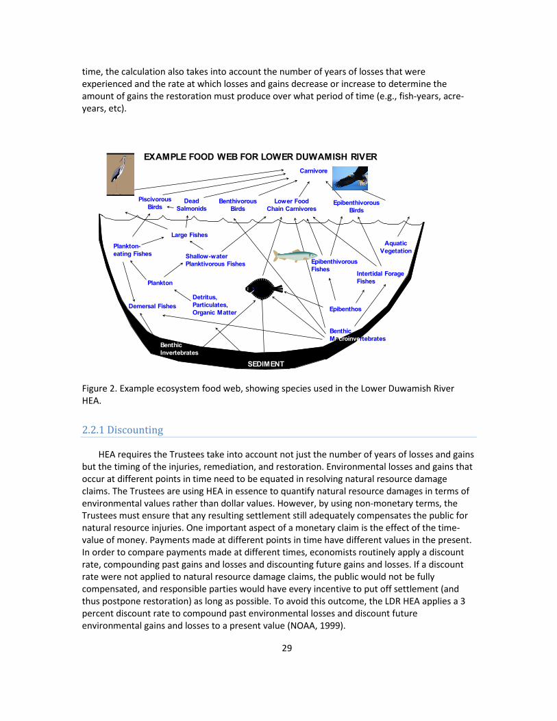
time, the calculation also takes into account the number of years of losses that were experienced and the rate at which losses and gains decrease or increase to determine the amount of gains the restoration must produce over what period of time (e.g., fish-years, acre-years, etc).
EXAMPLE FOOD WEB FOR LOWER DUWAMISH RIVER
Aquatic Vegetation
Carnivore
Piscivorous Birds
Benthivorous Birds
Lower Food Chain Carnivores
Epibenthivorous Birds
Large Fishes
Plankton-eating Fishes
Epibenthivorous Fishes Intertidal Forage
Fishes
Epibenthos
Shallow-water Planktivorous Fishes
Plankton
Demersal Fishes
Benthic Invertebrates
Detritus, Particulates, Organic Matter
Flatfishes
Benthic Macroinvertebrates
SEDIMENT
Dead Salmonids
Figure 2. Example ecosystem food web, showing species used in the Lower Duwamish River HEA.
2.2.1 Discounting
HEA requires the Trustees take into account not just the number of years of losses and gains but the timing of the injuries, remediation, and restoration. Environmental losses and gains that occur at different points in time need to be equated in resolving natural resource damage claims. The Trustees are using HEA in essence to quantify natural resource damages in terms of environmental values rather than dollar values. However, by using non-monetary terms, the Trustees must ensure that any resulting settlement still adequately compensates the public for natural resource injuries. One important aspect of a monetary claim is the effect of the time-value of money. Payments made at different points in time have different values in the present. In order to compare payments made at different times, economists routinely apply a discount rate, compounding past gains and losses and discounting future gains and losses. If a discount rate were not applied to natural resource damage claims, the public would not be fully compensated, and responsible parties would have every incentive to put off settlement (and thus postpone restoration) as long as possible. To avoid this outcome, the LDR HEA applies a 3 percent discount rate to compound past environmental losses and discount future environmental gains and losses to a present value (NOAA, 1999).
29

2.2.2 Lower Duwamish River Habitat Equivalency Model
To apply the LDR HEA, the Trustees perform the following steps: 1) identify the environmental components to measure losses from natural resource injuries and gains from restoration actions; 2) identify and quantify the losses that occurred; 3) identify the time period over which the losses occurred, and the rate at which any changes in the losses occurred; 4) calculate the total losses over time and apply the discount rate to the losses to determine the present value of the total losses; and 5) determine what restoration actions need to be undertaken to generate ecological service gains with a present value equal to the total losses. Each of these steps are summarized below.
1. Identify the environmental components to measure losses from natural resource injuries and gains from restoration actions.
Hazardous substances released to the environment have tended to accumulate in the sediments of the Lower Duwamish River. The organisms that live in and on the sediment, and that are exposed to sediment contamination, form the base of the food web on which most of the fish, birds, and other wildlife that use the Duwamish River environment depend. As illustrated by Figure 2, contamination of the sediments consequently affects nearly all aspects of the Lower Duwamish ecosystem. As mentioned above, Trustee studies and other research have documented the contaminant-related impacts to salmon and flatfish as well as benthic invertebrates. Studies also show that several species of birds are being exposed to hazardous substances at potentially harmful levels (Johnson et al., 2009).
Studies and extensive sampling conducted through EPA’s Superfund Remedial Investigation processes have delineated contaminated sediments throughout the LDR. Extensive studies conducted in other parts of Puget Sound (Commencement Bay) in addition to the Duwamish River, and the results of studies from elsewhere, have linked contaminated sediments with adverse impacts to trust resources, including flatfish, salmonids, and birds. Organisms can be exposed to contamination directly through contact with the sediments or water, or through the consumption of contaminated prey. But there can be injuries to resources outside of the LDR that are exposed to contaminants through other resources that had become contaminated in the Duwamish and then migrated to other areas in Puget Sound and beyond. A large number of different hazardous substances are contaminating LDR sediments and therefore a wide range of different types of adverse effects could occur to resources within the LDR and to resources outside the LDR that are indirectly impacted. The types of injuries to organisms can range from the minor effects (e.g., stimulation of enzyme pathways in response to contaminant exposure which results in the expenditure of energy in a detoxification process) to more serious impacts (e.g., impaired reproduction or death).
It would be extremely difficult and time-consuming to try to quantify injuries to all of the individual resources potentially impacted and to combine this information into resource service loss estimates for an HEA. The ecological service losses ultimately result from contaminated habitats, including those of the organisms that directly or indirectly depend on those habitats. Because of the central role that sediments and the sediment-based biological community play in the Duwamish Waterway, the Trustees decided to evaluate the potential loss of natural resources in terms of affected sediment habitat (i.e., loss of ecological services from the
30
sediments) rather than numbers of individual organisms impacted. This was done using existing sediment chemistry data together with injury thresholds developed by the Trustees. More detail on this approach is presented in Appendix C.
Juvenile Chinook salmon and English sole were used as representative species to assess the value of habitat to fish. Although the various fish species in the Duwamish Waterway display a variety of life history requirements, juvenile Chinook salmon and English sole have feeding modes, behavioral characteristics, and habitat requirements that sufficiently overlap those of similar species to consider them appropriate surrogates. Four bird assemblages, representing the bird species occurring in the area, were used to assess the value of habitat to birds. The four bird assemblages are grouped according to their foraging behavior and include both resident and migratory species. These four assemblages are: 1) shallow-probing and surface searching shorebirds (e.g., sandpiper), 2) waders (e.g., great blue heron), 3) surface and diving birds (e.g., lesser scaup), and 4) aerial searchers (e.g., osprey). The bird assemblages use similar habitat as juvenile Chinook salmon, and are linked through their food webs, so habitat value for birds is linked to habitat value for juvenile salmon. Existing habitats in the River were classified and a determination made of the value, or ecological services, these habitats provided to the representative species. Although birds and fish were used to determine the value of restoration projects, a great many different species will benefit from these restoration projects, including clams and other shellfish that will have additional clean habitat to utilize from these restoration efforts.
Currently, the LDR environment is dominated by deep channels, uplands, and steep hard-surfaced (e.g., rip-rapped) banks. The habitats that are in short supply are intertidal mudflats and marshes. These latter types of habitats are ecologically important as food sources, rearing and refuge areas, and spawning and nursery habitat for a variety of LDR species. Because of their scarcity, these habitats serve as a limiting factor on the overall health of the LDR environment. As described in Section 1.7, the Trustees’ restoration goals include developing a diversity of habitat types, with particular emphasis on habitats in short supply that are necessary to critical life stages of key injured species.
Trustees evaluated a range of habitat types in terms of their relative importance to impacted species. To keep the process manageable, the Trustees conducted the evaluation using Chinook salmon and English sole as representative fish species to assess the value of habitats to all fish. The Trustees used assemblages of bird species rather than individual species to assess habitat value to birds. Appendix D describes in detail the habitat needs of the selected species and assemblages.
Allowing for the creation of one habitat type to compensate for losses suffered in other habitat types requires the development of some means to equate different habitats. From a biological perspective, it is overly simplistic and difficult to calculate, for example, the amount of marsh habitat that needs to be created to compensate for contamination of LDR bottom sediments on a straight one-to-one, acre-for-acre basis. An acre-for-acre replacement approach does not take into account how the different habitats function or what ecological services the different habitats provide. Ecological services—providing food, cover, spawning, nursery or rearing habitat, refuge from predators, etc.—determine the value that different habitats have from a restoration perspective. As a result, the Trustees have decided to use the ecological
31

services provided by the various habitats as the environmental component for measuring losses from natural resource injuries and gains from restoration actions. In essence, ecological services function as the currency for equating losses and gains for different habitat types (Appendix D).
2. Identify and quantify the losses that occurred
In order to use the ecological services currency to identify and quantify losses from natural resource injuries, the Trustees assigned an ecological services value to each of the injured habitats and the habitats potentially to be created through restoration actions. To compare different habitat types, the Trustees first identified a benchmark, or “gold standard,” against which all habitat types would be measured. The Trustees reviewed scientific literature and consulted with experts to determine the benefits provided to key species by each of the other existing and potential LDR habitat types. Because of the Endangered Species Act listing of Chinook salmon and the significance of salmon to Indian Tribe Trustees and all regional populations, the Trustees weight habitats in terms of their importance to Chinook salmon at twice the value assigned due to their importance to flatfish or birds. Based on this analysis, the Trustees have created a matrix of assigned ecological service baseline values for the different habitat types that either exist now in the LDR or that may be the subject of restoration actions in the LDR. Since estuarine marsh habitats provide the greatest amount of ecological services to the species and species groups used as surrogates for all LDR resources, the ecological services provided by a given area of fully functioning estuarine marsh were chosen as that standard and assigned a baseline value of 1.0. The assigned baseline values range from 1.0 for fully functioning estuarine marsh, down to 0.1 for degraded habitat or areas of rip-rap. The following table shows the values assigned.
Table 1. Existing and Potential LDR Habitat Values
Habitat Fully Functioning Baseline Adjusted Degraded
Estuarine Marsh 1.0 0.85 NA
Intertidal 0.9 0.75 0.1
Shallow Subtidal 0.7 0.55 0.1
Deep Subtidal 0.3 0.3 0.1
Rip-rap NA NA 0.1
The table introduces two additional habitat valuation concepts to the fully functioning concept: baseline adjusted and degraded. The Trustees adjust the baseline values of specific habitat areas to reflect the fact that habitats function in connection with each other. For certain habitat types to be fully functional, they must exist in conjunction with and interact with an adjacent habitat, often of a particular type, forming habitat complexes that enhance overall production. Habitats considered baseline adjusted do not have these adjacent habitats to enhance their function and are therefore assigned a lower value. For example, intertidal habitats not associated with an adjacent vegetated buffer or an adjacent, fully functioning marsh are designated baseline adjusted and given a value of 0.75. Based on a review of the
32

physical characteristics present in the LDR, the Trustees have designated all existing intertidal and shallow subtidal habitats within areas contaminated above injury thresholds in the waterway as baseline adjusted.
The Trustees assign a designation of degraded to specific habitat areas to reflect the fact that hazardous substance contamination has not been the only source of harm to the LDR environment. LDR habitats have been degraded by development, physical modification, and non-hazardous pollution, among other things for which CERCLA does not authorize Trustees to recover natural resource damages. Degraded values are assigned when shading is cast by over-water structures. Over-water structures such as piers, aprons, buildings, etc., inhibit the production of benthic species that serve as food sources for fish. They also interfere with salmon migratory movements and feeding and render shaded areas less valuable for juvenile salmon.
To reflect the effects of these conditions, the Trustees assign a degraded value of 0.1 to intertidal and shallow subtidal habitats under over-water structures. The degraded classification is applied narrowly, only to situations causing severe physical impacts. Rip-rap is a special category of degraded habitat, reflecting its limited value to fish or birds. A more detailed explanation of the assignment of ecological service values and the underlying information and literature on which it is based can be found in Appendix D.
To quantify the impact of hazardous substances, the Trustees begin with the assumption that habitats contaminated to the point that they cause harm to species that use them provide less in the way of ecological services than do uncontaminated habitats. The Trustees reviewed scientific literature, technical data, applicable regulatory standards, and the results of their own studies to determine the effect that varying sediment concentration levels of the different hazardous substances have on key species or species groups. The Trustees judge contamination to be injurious when the concentration of the contaminants in the sediments is sufficient to result in an adverse effect to identified species. The adverse effects range from subcellular alterations up to mortality. The information shows that as hazardous substance sediment concentrations increase, the number of species adversely affected increases, and the effects themselves increase in severity. From this information, the Trustees have developed a series of concentration threshold levels for each hazardous substance, and have assigned to each threshold an increasing percent reduction in ecological services per unit of habitat. A description of this process, including tables showing threshold concentrations and percent service reductions, are included in Appendix D.
3. Identify the time period over which the losses occurred, and the rate at whichany changes in the losses occurred
Once hazardous substances come to rest in marine sediments, many remain biologically available and can contribute to natural resource injuries over an extended period of time. The contaminants can cause ecological service reductions over a series of years, beginning when the concentrations reach injurious levels and continuing until the sediments are remediated or naturally recover. There are at present in the LDR some prominent areas of sediments contaminated by PCBs, for example, years after their production and use in the United States was banned. Releases of contaminants to the LDR, and resulting natural resource injuries, have occurred over many years. Significant efforts by industry and regulatory agencies to control
33
many releases did not begin in earnest at some LDR facilities until well into the 1980s or later. Much of this effort has only begun to have an impact on sediment contamination.
Although natural resource injuries have apparently been occurring for decades, CERCLA precludes recovering natural resource damages where the damages and the releases from which the damages resulted occurred wholly before December 11, 1980. CERCLA’s stipulation that both the releases and damages must have occurred prior to that date to be exempt from the statute means that the Trustees can legally seek compensation for natural resource damages that occurred after that date even if the release that resulted in the damages occurred before it. The Trustees ultimately must exercise their discretion and authority in determining, within the limits of CERCLA, what compensation they will consider appropriate from the PRPs for natural resource injuries. In the LDR, the Trustees have focused on restoration that would be scaled based on ecological service losses post-CERCLA (1981) through the completion of natural recovery following remediation.
The Trustees assume that service losses from contamination have occurred and will continue to occur at a constant rate until completion of remediation. Once the remediation is completed, the Trustees assume that ecological services provided by the affected area will increase at a constant rate until the area produces the services it would otherwise produce but for the contamination. The Trustees factor in the latest information on scheduled or proposed remediation and the estimated year they are expected to be completed. Trustees assume that areas subject to active remediation will recover to full service levels 4 to 10 years after remediation (depending on the type of remediation), and that areas subject to natural recovery will take 25 years to recover.7
4. Calculate the total losses over time and apply the discount rate to the losses to determine the present value of the total losses
To pull together the assignments of habitat ecological services, designation of degraded areas, and service reductions from contamination, and to show the effect of remedial plans, the Trustees have compiled a database of relevant information and used that database to develop a series of maps using a geographical information system (GIS). The Trustees developed GIS map layers showing habitat types (in terms of water depth and type of substrate, reflecting judgments about degraded conditions), baseline adjustments, areas exceeding hazardous substance threshold concentrations, and areas for which active remediation is planned. When the map layers are overlaid, the result is a combined map showing a series of patches or polygons, each with a unique combination of ecological characteristics. Figure 3 presents a portion of the GIS map for the LDR showing the polygons generated by the combined map layers.
7 Presumably, areas actively dredged as part of the remedial process will have injurious concentrations of contaminants immediately removed. However, it will take time for benthic organisms to re-colonize these areas to the point that they are generating the levels of ecological services they would be expected to produce.
34
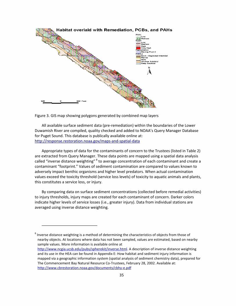
Figure 3. GIS map showing polygons generated by combined map layers
All available surface sediment data (pre-remediation) within the boundaries of the Lower Duwamish River are compiled, quality checked and added to NOAA’s Query Manager Database for Puget Sound. This database is publically available online at: http://response.restoration.noaa.gov/maps-and-spatial-data
Appropriate types of data for the contaminants of concern to the Trustees (listed in Table 2) are extracted from Query Manager. These data points are mapped using a spatial data analysis called “inverse distance weighting” 8 to average concentration of each contaminant and create a contaminant “footprint.” Values of sediment contamination are compared to values known to adversely impact benthic organisms and higher level predators. When actual contamination values exceed the toxicity threshold (service loss levels) of toxicity to aquatic animals and plants, this constitutes a service loss, or injury.
By comparing data on surface sediment concentrations (collected before remedial activities) to injury thresholds, injury maps are created for each contaminant of concern. Darker colors indicate higher levels of service losses (i.e., greater injury). Data from individual stations are averaged using inverse distance weighting.
8 Inverse distance weighting is a method of determining the characteristics of objects from those of nearby objects. At locations where data has not been sampled, values are estimated, based on nearby sample values. More information is available online at http://www.ncgia.ucsb.edu/pubs/spherekit/inverse.html. A description of inverse distance weighting and its use in the HEA can be found in Appendix E: How habitat and sediment injury information is mapped via a geographic information system (spatial analysis of sediment chemistry data), prepared for The Commencement Bay Natural Resource Co-Trustees, February 28, 2002. Available at: http://www.cbrestoration.noaa.gov/documents/cbhy-e.pdf
35

Table 2. Substances of Concern for the Lower Duwamish River NRDA
Metals Arsenic Cadmium Chromium Copper Lead Mercury Silver Zinc Tributyltin Chlorobenzenes 1,2-dichlorobenzene 1,4-dichlorobenzene 1,2,4-trichlorobenzene Hexachlorobenzene Other PAHs (total) PCBs (total)
Phenols 4-methyl phenol 2,4-dimethyl phenol Phenol Hexachlorobutadiene Phthalates bis(2-Ethylhexyl) phthalate Butylbenzyl phthalate Di-n-butyl phthalate Di-n-octyl phthalate dimethylphthalate Pesticides DDD DDE DDT
The particular combination of characteristics and habitat types that define a polygon generates a specific value of ecological service loss for that polygon. Taking into account the size of the polygon, and applying assumptions about the timing of remedial action and rates of recovery for remediated and un-remediated areas, a value of service acre-years loss is generated for the polygon. Adding those figures for all polygons produces a total service acre-years loss for the waterway as a whole. Applying the 3 percent discount rate to past and future losses to determine their present value results in a calculation of a total discounted service acre-years (DSAYs) loss.
5. Determine what restoration actions need to be undertaken to generate ecological service gains with a present value equal to the total losses
Calculating the amount of restoration needed to compensate for the natural resource injuries follows a similar analysis, using the same assumptions. As the goal of natural resource damage assessment is to compensate the public for natural resource losses, the objective of a restoration-based settlement must be to produce ecological service gains that would not otherwise occur that are equivalent to the calculated service losses.
To judge the gains expected from an individual proposed restoration project, the Trustees begin by calculating the present value of the ecological services the project site would generate without the restoration project. The Trustees analyze the current condition of the project site to determine the type of habitat present and the level at which it is functioning, and make informed judgments about any potential change in the service levels the site would provide
36

without the project into the future. This information is used to calculate the present value of the total service acre-years the site would provide if the project were not built. A proposed project design must then be developed and reviewed to determine the types of habitat and levels of services the project will provide once constructed. The services to be provided each year of the project are summed up and the present value of the total service acre-years calculated. Subtracting the DSAYs produced by the site without the project from the DSAYs to be produced by the site assuming the project is constructed generates the total DSAY gain from the project.
Since proposed projects have obviously not yet been constructed, the Trustees must predict the likelihood of project success and the rate at which project elements may change over time (e.g., growth rate for vegetation) based on their own experience and the experience of others. Appendix C details the information and analysis Trustees have used in developing projections for the time different habitats will require to reach full function. Chapters 6 and 7 describe example restoration projects of types the Trustees expect to be developed and illustrate how the Trustees will evaluate the DSAY credit to be granted to proposed projects.
2.2.3 Allocation of Liability
Releases of hazardous substances into the LDR have become commingled and have likely combined to cause injury to trust resources. Under these circumstances, the law holds any party contributing to the contamination to be jointly and severally liable for the whole injury; however, in order to encourage settlement, the Trustees have attempted to apportion settlement shares among responsible parties. The Trustees have allocated the proposed settlement among LDR facilities or sites, and have not attempted to apportion liability among multiple parties responsible for individual sites or facilities. They have relied upon publicly available data and information, obtained mainly from the files of EPA and the Washington Department of Ecology, along with information obtained from public libraries. Details of the allocation process are discussed in more detail in Appendix F.
The Trustees’ allocation analysis is designed to be fair and equitable to PRPs while ensuring that the interests of the public are appropriately served. To trigger allocation of liability to a site there has to be evidence of a pathway for water or sediment to travel from the site to the LDR, and evidence of an activity conducted at the site that is a likely source of a substance of concern. In addition, there has to be evidence of actual environmental contamination by the hazardous substance due to a water pollution control permit violation; the presence of contamination in surface water, groundwater, soil or sediment; or the presence of a sediment contamination footprint adjacent to the site.
Responsibility for contamination was based on the footprint maps, tax parcel information, and data on types of activities occurring on parcels adjacent to the LDR, the substances used or stored on site, wastewater, soil, groundwater and other sampling data, reports of spills/releases, and similar factors. Rather than assigning each facility associated with a particular contaminant a fixed percentage of liability, for settlement purposes the Trustees first apply a contaminant footprint approach to the extent possible. By examining concentration gradients of contaminants in surface sediments, and reviewing available information on hazardous substance releases, the Trustees have assigned liability for areas of sediment contamination to one or more facilities for most contaminants.
37

For some contaminants with widespread distribution such as polycyclic aromatic hydrocarbons (PAHs), allocation by discrete footprint to individual sites is not possible. For these contaminants, the Trustees use a mass-loading approach, which relies on a relative comparison of the duration and area of operations associated with releases and of the extent to which the type of activities conducted at each facility is likely to have generated significant releases. In cases where a large footprint can be linked to several sites, the Trustees employ a combination of the footprint and mass-loading approaches.
Using each of the above approaches still leaves some areas of waterway contamination unallocated based upon information currently available. Where there is no apparent connection to any facility, the Trustees designate the footprint involved as Type I Non-Allocated. Where there is an apparent physical connection between a footprint and a facility but no information indicating activities that may have resulted in the release, the Trustees designate the footprint as Type II Non- Allocated.
The Trustees use each of the above approaches to allocate liability for DSAY reductions generated by the contaminants in all the mapped polygons described earlier. As mentioned previously, the Trustees allocate liability to facilities rather than to parties and are expecting multiple parties associated with a given facility to resolve among themselves how to sub-allocate that facility’s share of liability.
It is important to underscore that the Trustees have developed this allocation solely for settlement purposes. By performing this allocation, the Trustees are not suggesting or conceding that the effects of LDR contamination are readily divisible among contaminants, natural resource injuries, facilities, or parties. In the event that not all LDR natural resource damage claims can be resolved through settlement, the Trustees reserve the right to pursue all possible claims against non-settling parties on a joint and several liability basis through litigation.
2.3 Alternate Methods for Injury Assessment
The U.S Department of the Interior (DOI) NRDA regulations provide for a variety of methods to quantify damages (see 43 CFR 11.83). When HEA is used to quantify injuries, the cost of projects identified to restore an equivalent level of services represents the measure of damages. Alternatively, losses may be quantified in terms of compensable value using economic valuation methods. Compensable value reflects the change in the value of the resource due to injury and includes both use and nonuse components. Use value is the value of resources attributable to direct use, such as recreation. Nonuse value is the value of resources independent of any current or future use, motivated by a desire to preserve resources for future generations or to protect and maintain them in a natural state. Compensable value is typically expressed in terms of consumer surplus. Consumer surplus is the amount individuals are willing to pay for a good or service above and beyond what they may be required to spend. If an individual’s willingness to
38

pay for a good or service decreases (e.g., due to the impacts of contamination), a loss in surplus results.9
Valuation methods specified by the DOI NRDA regulations can be divided into two categories: market and non-market. Valuation via market prices is appropriate in circumstances when injuries have increased the cost of resource use, reduced the quality or quantity of the resource available for market, or induced changes in the market price of the resource. However, if injured resources are not traded and priced explicitly in markets, as is often the case, non-market valuation methods must be used. Non-market valuation methods are further divided into two types: revealed preference and stated preference.
Revealed preference methods infer values for natural resources and associated services from consumer behavior. For example, the value of a day of beach recreation can be estimated using information on the costs one incurs to travel to that beach (referred to as travel cost methods). Similarly, the value of an environmental amenity may be revealed through land and housing price premiums (referred to as hedonic methods).
Stated preference methods involve creation of a hypothetical market that allows individuals to explicitly state their value for a resource. This is accomplished through carefully designed and implemented surveys (referred to as contingent valuation and choice experiment methods). Damage estimation for the social, cultural, and spiritual loss of natural resources to affected tribes can be assessed using the Contingent Valuation Methodology or by using other valuation techniques.
Finally, when circumstances do not justify the time and expense required to implement a primary study using revealed or stated preference methods, secondary methods (i.e., methods that rely on information generated by other studies) can be used. This most common secondary method used in NRDA analyses is referred to as “benefit transfer,” a process where existing valuation information is adapted to new and/or alternative contexts. Within the DOI NRDA regulations this is referred to as the “unit value methodology.”
With respect to losses associated with degraded habitats in the LDR, two potential valuation approaches could be applied. First, a benefit transfer analysis could be undertaken where existing values for similar changes in ecological services are assigned to a relevant population of individuals or households. However, the accuracy and reliability of benefit transfer analyses depends critically upon the similarity between the conditions to be valued and those studied in existing literature. In this case it is unlikely that value estimates exist that adequately correspond to the specific injuries and associated ecological service losses documented in the LDR.
Second, a primary stated preference study could be undertaken. In this case, a survey would be developed to elicit individuals’ or households’ willingness to pay to avoid or restore ecological service losses within the LDR. Aside from the substantial time and expense likely associated with conducting such a study, there is uncertainty as to whether reliable economic
9 Consumer surplus also can decrease if the price of a good or service increases.
39
values could be estimated. The accuracy and reliability of values derived from stated preference studies depends in part upon the extent to which the specific change to be valued is accurately and completely characterized and, in turn, fully understood and appreciated by survey respondents. In the case of the LDR, sediment contamination and associated injury to benthic habitats (and the biota that rely on those habitats) is likely to have manifested in a variety of complex ecosystem changes that would be difficult to translate into a cogent valuation scenario.
Thus, in this specific case, damage estimation via the direct cost of equivalent habitat restoration and enhancement actions (i.e., HEA) is a reasonable and appropriate approach.
40
3. ENVIRONMENTAL SETTING/AFFECTED ENVIRONMENT
For purposes of the Restoration Plan and the Programmatic Environmental Impact Statement, the LDR environment is defined as the river from the northern (downstream) tip of Harbor Island upstream to the feature known as North Winds Weir (located approximately seven miles upstream).
3.1 Affected Environment
The LDR watershed lies within King County, Washington. The area of restoration focus begins at North Winds Weir and ends in Elliott Bay in the vicinity of the mouth of the Duwamish River, Puget Sound. The water flows approximately seven miles through the most industrialized sections of the river (see Figure 4).
3.1.1 Sediment Quality
The LDR receives contaminant inputs from industrial activities and other sources, much of which has ended up in the sediments. Discharges and releases of oil and hazardous substances into the waterway resulted from current and historical industrial and municipal activities and processes since the early 1900s. Facilities released materials through permitted and non-permitted discharges, spills during cargo transfer and refueling, stormwater runoff through contaminated soils at upland facilities, and discharge of contaminated groundwater. The primary exposure pathways of a contaminant from media to receptors are via contaminants that accumulate in the sediments. The sediments in the estuary are contaminated with metals, petroleum products, and other organic materials (ACOE, 2000). The organisms that live in and on the sediments, and that are exposed to sediment contamination, form the base of the food web upon which most of the fish, birds, and other wildlife that use the LDR environment depend. Contamination of the sediments affects nearly all aspects of the LDR ecosystem. Contaminants have been found in tissues of benthic invertebrates and fish in the Duwamish Waterway, indicating that contamination from the sediments is being accumulated by organisms.
The Remedial Investigation Report for the Lower Duwamish Waterway Superfund Site and the Harbor Island Superfund Site Second Five-Year Review Report characterize the contamination of the LDR and the progress of remediation to date for these two superfund sites (EPA, 2005; LDWG, 2010a). Additional information can be found in the Draft Final Feasibility Study for Lower Duwamish Waterway (LDWG, 2010b) and the East Waterway Operable Unit Existing Information Summary Report (Port of Seattle, 2008). This information is incorporated here by reference.
3.1.2 Air Quality
The Puget Sound Clean Air Agency (PSCAA) is the primary entity responsible for regulating air pollution from business and industrial activities in King, Kitsap, Pierce, and Snohomish
41

counties. PSCAA issues air quality data summary reports annually that summarize regional air quality by presenting air monitoring results for six criteria air pollutants. The EPA sets national ambient air quality standards (NAAQS) for these pollutants: particulate matter (10 micrometers and 2.5 micrometers in diameter), ozone, nitrogen dioxide, carbon monoxide, sulfur dioxide, and lead. The Air Quality Index (AQI) is a nationwide reporting standard developed by the EPA to report daily air quality. For 2009, King County reported 75 percent “good” days, 24 percent “moderate,” and 1 percent “unhealthy for sensitive groups” (Puget Sound Clean Air Agency, 2011).
Figure 4. Map showing Duwamish/Green River Lower watershed and location of Lower Duwamish River.
Beginning in 2004, the agency added additional information on air toxics to the Air Quality Data Summary. Air toxics are pollutants broadly defined by the agency to include over 400 chemicals and compounds. Most air toxics are a component of either particulate matter or
42
volatile organic compounds so there are overlaps between the criteria pollutants and toxics. Toxic pollutants are associated with a broad range of adverse health effects, including cancer.
PSCAA and the Washington State Department of Ecology work together to monitor air quality within the Puget Sound region. Real-time air monitoring data are available for some pollutants online at http://www.pscleanair.org/airq/aqi.aspx. Continuous air monitoring data provide information on how concentration levels of various pollutants vary throughout the year. An air monitoring station is located close to the Duwamish River at 4401 E. Marginal Way.
A recent study of air quality associated with the South Park Bridge Project gives much more in-depth information about air quality and is incorporated here by reference (King County Department of Transportation, 2004). It is available online at http://your.kingcounty.gov/kcdot/roads/cip/addlContent/documents/files/300197_DEIS_v4.pdf
3.1.3 Water Quality
Water quality in the Duwamish River has been characterized by King County Water and Land Resources as “fair,” the Lower Green as “fair to good,” and the Middle Green as “good to very good” (King County Water Quality Monitoring, Green River Watershed. http://green.kingcounty.gov/WLR/Waterres/StreamsData/WaterShedInfo.aspx?Locator=0311). King County conducted a water quality assessment of the Duwamish River and concluded that the levels of contaminants in the water posed “minimal” risk to aquatic life (King County, 1999).
State water quality standards were revised in 2003 (http://www.ecy.wa.gov/programs/wq/swqs/index.html). Under the 2003 rules the Duwamish River is categorized as “Salmonid Rearing and Migration Only” habitat. For recreational use the Duwamish is designated as “Secondary Contact.” The Duwamish Waterway and River is on the Washington Department of Ecology’s 303(d) 2004 list for not meeting Dissolved Oxygen, Fecal Coliform, pH, and various sediment toxics standards.
Additional information on water quality in the LDR is available from King County (1999) and in the Remedial Investigation (LDWG, 2010).
3.1.4 Potential Impacts of Climate Change on Proposed Restoration
The climate in the basin is a mid-Atlantic, west coast marine type characterized by cool wet winters and mild summers. The average rainfall in the basin ranges from 39 to approximately 100 inches annually. Approximately 75 percent of the precipitation falls between the months of October and April. The summer months from July through September are typically characterized by minimal, if any, precipitation, causing flows in the river to drop to minimums and water temperatures to increase (ACOE, 2000). Temperature extremes are moderated by the adjacent Puget Sound and Lake Washington as well as the more distant Pacific Ocean. The region is partially protected from Pacific storms by the Olympic Mountains and from Arctic air by the Cascade Range. As for temperature, winters are cool and wet with average lows around 35–40 F (2–4 C) on winter nights. Colder weather can occur, but seldom lasts more than a few days.
43

Summers are dry and warm, with average daytime highs around 73–80 F (22.2–26.7 C). Hotter weather usually occurs only during a few summer days (http://www.weather.com/).
Climate change is projected to impact Washington State in several ways, including sea level rise, increases in air and water temperatures, and changes in patterns of peak stream flows. While specific impacts will vary across the state, it is anticipated that the LDR and the habitats located there may be affected by sea level rise, changes in the quantity and timing of peak river flows, temperature increases, and changes in the waters of Puget Sound (such as stratification of the water or circulation patterns) (King County, 2005a; University of Washington, 2005).
Sea level rise is of particular concern in coastal areas. Factors influencing local sea level rise include global sea level rise, local land movement (such as tectonic land movement), and changes in wind patterns (University of Washington and Washington Department of Ecology, 2008). This recent report looks at the factors influencing sea level rise for coastal areas in Washington State, including Puget Sound. Relative vertical land movement in the Puget Sound area is not completely clear, as different reports show a range of values for vertical land movement. While the local rates of vertical land movement are somewhat uncertain, the driving factor of sea level rise in Puget Sound is the global sea level rise (see Table III, University of Washington and Washington Department of Ecology, 2008). For Puget Sound, the estimated very low, medium, and very high sea level rises are:
By 2050: very low = 8 cm (1”); medium = 15 cm (6”), very high = 55 cm (22”)
By 2100: very low = 16 cm (6”); medium = 34 cm (13”), very high = 128 cm (50”)
Estimated sea level rise must be considered for tidal and estuarine habitats. To ensure survival of the plant and animal communities, the habitat must have room to migrate upslope and stay at the same intertidal elevation required for the specific organisms. For example, if the water level increases over time, but there is no space upslope for a tidal marsh to migrate (i.e., located against a steep slope), the wetland will not be able to survive in the long term. The Trustees will endeavor to locate and develop restoration projects in such a way as to maximize the opportunity for restored habitats to migrate upslope. However, given the limited availability of property along the LDR, there are likely to be some restoration projects that could be negatively affected if some of the more severe predictions about sea level rise over the next couple of centuries are correct.
In addition to sea level rise, other impacts of climate change to Puget Sound and the LDR habitats are predicted from projected changes in air temperature and precipitation (King County, 2005a; University of Washington, 2005). Warmer air temperatures change the type of precipitation, with less precipitation falling as snow and more as rain; this in turn leads to another possible impact of climate change—a change in the quantity and timing of peak river flows. Restoration projects should consider the potential for changes in the quantity and timing of river flows. Since the Green River is dam regulated, flooding events are less likely to be a concern in the LDR (Washington State Department of Ecology and Department of Community, Trade, and Economic Development, 2006).
In addition to the freshwater system impacts, increases in the temperature of Puget Sound marine waters as well as the timing and quantity of freshwater inputs could impact the
44
stratification of the marine waters, contributing to low oxygen events.
3.2 Physical Environment
The topography and character of the Green/Duwamish River Basin vary dramatically between its headwaters and mouth. The upper watershed is largely undeveloped and managed almost entirely for timber production. The terrain is generally steep and forested, timbered mainly by conifers except along the river and stream channels where deciduous and mixed forest stands dominate. In the upper basin above Howard Hansen Dam and reservoir, few manmade structures confine or restrict the river channels. In the middle basin below the Green River Gorge (River Mile 47) the Green River reaches the gentle slope of the valley floor. Much of the original forestland has been converted to farmland, and levees increasingly confine the river channel. Most of the lower basin (where this restoration plan applies) has been highly altered by the clearing of the original forestlands and the filling of freshwater and estuarine wetlands and intertidal flats, and now consists largely of industrial and residential development. The river channel is highly restricted along both banks by levees or rock revetments, and is dredged periodically between its mouth and River Mile 5.5 for navigation. Approximately 99 percent of the former estuarine wetlands and mudflats have been either dredged or filled in for industrial purposes (U.S. Department of Interior- Fish and Wildlife Service, 2000; U.S. ACOE, 2000).
The lower Green/Duwamish River valley was once a marine fjord to the town of Sumner. The Osceola Mudflow (5,800 years ago), and later mudflows occurring 2,500 and 1,100 years ago, provided sediment that gradually filled the marine embayment (Dragovich et al., 1994; Zehfuss et al., 2003). The soils of this lower valley are poorly studied because there has been extensive urban and industrial development along the river for many years. It is expected that most of the soils were alluvial in nature with significant quantities of organic material from the floodplain swampland and marshlands. Fill material from other sources has been placed in most of the floodplain.
Extensive water regime and channel modifications resulted in existing habitat conditions that were not historically present in the Green/Duwamish River system (Blomberg et al., 1988; King County, 2005b). Prior to 1910, the Duwamish River drained a much larger watershed including all flows from the present Green River watershed, the Lake Washington drainage basin, and the White River. Both natural and man-made modifications during the early 1900s reduced the drainage basin to its present size and configuration. Flows from the White River were diverted to the Puyallup River by a flood in 1906, and later man-made structures made this diversion permanent. Flows from Lake Washington were diverted west to Lake Union and Salmon Bay after the construction of Ballard Locks and Lake Washington Ship Canal in 1916. Around the same time, the Cedar River was diverted from the Black River into Lake Washington, so that the Green River no longer received those flows. By 1913, the City of Tacoma completed a water diversion dam on the Green River, with a maximum withdrawal of 113 cfs. In 1962, Howard Hansen Dam was built in the Eagle Gorge of the upper Green River for flood control and low flow augmentation.
Currently, the Green/Duwamish River drains about one-quarter of its original watershed (Warner and Fritz, 1995). The mean annual flow for the Duwamish River was estimated at 2,500 to 9,000 cfs prior to the diversions (Fuerstenberg et al., 2003). By 1996, the mean annual flow
45

the Duwamish River was estimated to be approximately 1,700 cfs (ACOE, 1997). The long-term mean flow rate in the river from 1961 (when the Howard Hansen Dam was constructed) to 2004 is 1,340 cfs (LDWG, 2008).
The ACOE maintains a navigable waterway through dredging to the Upper Turning Basin. The typical cross section of the LDR includes a deeper maintained navigation channel in the middle, with shallow benches at intermittent locations along the margins of the channel (LDWG, 2008). The river banks are primarily occupied by structures, including piers and buildings, or armored with rip-rap and concrete debris. A bottom layer saltwater wedge moves up and down stream with the tide and stream flow, while freshwater moves downstream in a layer over the top of the salt wedge (Stoner, 1972).
3.3 Biological Resources
Historically, the Green/Duwamish River basin was heavily forested with evergreen coniferous trees and an understory of various shrubs, ferns, and herbs. In the lower valley, emergent wetland vegetation was interspersed with forested riparian (alder, willow, cottonwood) and patches of swamp with cedar and spruce. The Duwamish River meandered through an extensive estuarine zone where freshwater marsh transitioned into brackish and salt marsh with extensive mudflats. The estuary, marshy floodplain, and forested basin were utilized by many species of migratory and resident waterfowl, songbirds and raptors, large and small mammals, amphibians, and reptiles (King County, 2005b)
Fish species that were historically present in the basin included Chinook, coho, sockeye, pink and chum salmon, steelhead and sea-run cutthroat trout, Dolly Varden and bull trout, resident rainbow and cutthroat trout, and other resident fish (ACOE, 2000). A total of 53 resident and non-resident fish species were identified during the fish sampling conducted for the EPA Remedial Investigation (EPA, 2007). Significant numbers of Chinook, coho and chum salmon, and steelhead trout are released from state and tribal hatcheries.
Currently, the lower Green/Duwamish River basin is highly urbanized along most of the river corridor, particularly in the lower 12 miles. Upstream of the Duwamish Waterway, extensive levees line the river protecting residential, commercial, and industrial properties adjacent to the river. Small patches of red alder, black cottonwood, big-leaf maple, and willow grow along the riverbank, which is typically confined between flood control levees. More commonly, Himalayan blackberry and various grass species dominate the channel bank vegetation. Swallows, sparrows, coyote, raccoon, and river otter inhabit these remnant habitats.
Birds
An estimated 330,000 birds winter in Puget Sound, and several million shorebirds and other waterbirds stop during migration. Puget Sound is nesting habitat for an estimated 33,000 seabirds and South Puget Sound provides for approximately 30 percent of the total midwinter waterfowl use of Washington’s coastal areas (U.S. DOI, Fish and Wildlife Service, 1982). Nearly 100 bird species (see Appendix A) have been observed in the Duwamish River estuary, including migrating shorebirds, loons, grebes, alcids, geese, surface feeding and diving ducks, raptors, kingfishers, gulls, and terns (Cordell et al., 1999; EBDRP, 2000; FWS, 2006). Two recently de-
46
listed migratory bird species under the Federal Endangered Species Act (ESA)—peregrine falcon (Falco peregrinus) and bald eagle (Haliaeetus leucocephalus)—are known to forage or spend time in the Elliott Bay/Duwamish River system (Anderson and Osmek, 2005; Cordell et al., 2001).
Several nesting areas have been identified in the vicinity of Harbor Island in the Elliott Bay area. They include the cavity-nesting pigeon guillemots (Cepphus columba) found historically in the West Duwamish Waterway under the P/S Freight Dock and Terminal Five in 1994 (U.S. DOI, Fish and Wildlife Service, 1989). Great blue heron (Ardea herodias) have nested in the bluffs of West Seattle just west of the Duwamish estuary since the 1940s (U.S. Department of Commerce (U.S. DOC, NOAA, 1985), but abandoned these colonies in 1999 (U.S. DOI, Fish and Wildlife Service, 2002). Since 2003, osprey (Pandion haliaetus) have begun nesting along the LDR from confluence of the Green River to Harbor Island in Elliott Bay (U.S. DOI, Fish and Wildlife Service, 2007). Kellogg Island, immediately upstream of Harbor Island, provides nesting and roosting habitat for a number of migratory and resident avian species including neotropical songbirds, raptors, and other waterfowl. Kellogg Island has also provided habitat for uncommon nesters to Western Washington such as the Northern oriole (Icterus galbula bullockii), gadwall (Anas strepera), and spotted sandpiper (Actitis macularia) (Port of Seattle, 1979).
Federally Listed Species
Federally listed threatened salmonid species under the ESA that are known to occur or may be found in the vicinity of the proposed projects include Coastal-Puget Sound bull trout, Puget Sound Chinook, and Puget Sound steelhead (WDFW, 2008). Other federally listed species that may occur within the area proposed for projects includes Steller sea lion, humpback whale, southern resident killer whale, leatherneck sea turtle, and marbled murrelet. Federal Species of Concern include bald eagle and peregrine falcon (U.S. DOI, Fish and Wildlife Service, 1986). In addition, the LDR is essential fish habitat for Chinook and steelhead* (*under development as of October 2011) (NOAA, http://www.nwr.noaa.gov/protected_species/salmon_steelhead/salmon_and_steelhead.html). The State of Washington has listed Orca and humpback whales and leatherback sea turtles as endangered species. The state lists Steller sea lions as threatened species and lists bald eagle, peregrine falcon, purple martin (Carpodacus purpureus), and coho and chum salmon as species of concern.
Chinook Salmon
Puget Sound stocks of Chinook salmon (Oncorhynchus tshawytscha) are listed as a threatened species. The species occurs in the Green/Duwamish basin from the River mouth up to the Tacoma diversion dam. Designated critical habitat for Puget Sound Chinook salmon within the overall areas targeted for restoration (detailed in Section 5.6) include freshwater rearing sites, freshwater migration corridor, and estuarine and nearshore marine areas with appropriate environmental conditions. For this and other threatened and endangered species, specific analysis for the presence of, and potential effect on, critical habitat will be conducted for individual projects at their specific locations (within the overall area of restoration focus of this RP/PEIS) during consultations under the ESA.
Key habitat requirements for Chinook salmon include adequate stream flow, high-quality gravel for spawning, low temperatures, side channels, and estuarine habitat for rearing. The lack
47

of side channels and estuarine habitat is a significant issue for Chinook salmon production. The natural origin Chinook salmon of the Duwamish River are included in the Puget Sound Evolutionarily Significant Unit (ESU). This ESU of Chinook salmon was listed in 1994. Decline for the species has been attributed to pollution, hydropower operations, harvest practices, hatchery practices, and the degradation and loss of habitat. Recovery for the species requires the improvement and integration of hatcheries, hydropower, harvest, and habitat (the “four Hs”). In the Duwamish River the Chinook salmon population ranges from 2,450 to 11,500 adults per year (Green/Duwamish and Central Puget Sound Watershed Resource Inventory Area 9 (WRIA 9), 2005, 2006a, 2006b). In the LDR one of the main limitations for species recovery is the lack of estuarine and off-channel habitat as well as the lack of habitat within the transition zone, where juveniles osmoregulate from freshwater to saltwater. This lack of habitat in critical areas has resulted in reduced growth rates for juvenile Chinook.
Bull Trout
Coastal-Puget Sound bull trout (Salvelinus confluentus) are listed as a threatened species. Puget Sound populations include both resident and migratory forms. The LDR is part of the Puget Sound Management Unit for bull trout. Historically, bull trout were found in abundance in the middle Green River basin. Currently no bull trout stock is recognized in the Duwamish/Green River. However, anadromous bull trout regularly visit the lower Duwamish downstream of river mile 5.8 (King County, 2003b). Bull trout inhabit side channels and stream margins and need woody debris and other complex forms of cover to hide from predators and to find prey. Unlike other salmonids, bull trout survive to spawn year after year (Shared Strategy for Puget Sound, 2007). Critical habitat for bull trout within the overall area targeted for restoration includes freshwater rearing, foraging, and overwintering habitat and estuarine/marine areas with the appropriate environmental conditions. As is the case for Chinook salmon, specific analysis for the presence of, and potential effect on, critical habitat will be conducted for individual projects at their specific locations (within the overall area of restoration focus of this RP/PEIS) during consultations under the ESA.
Steelhead
Puget Sound steelhead (Oncorhynchus mykiss) was listed as a threatened species on May 11, 2007. The distinct population segment includes all naturally spawned anadromous winter-run and summer-run steelhead populations in streams in the river basins of the Strait of Juan de Fuca, Puget Sound, and Hood Canal, Washington, bounded to the west by the Elwha River (inclusive) and to the north by the Nooksack River and Dakota Creek (inclusive), as well as the Green River natural and Hamma Hamma winter-run steelhead hatchery stocks (NOAA, 2007). Winter Steelhead enter the Duwamish River from November to May and spawn in the upper Green River and its tributaries. In addition to the wild stock, hatchery produced summer and winter steelhead also occur in the watershed (King County, 2003a). No critical habitat has yet been designated for Puget Sound steelhead, although their requirements would be similar to those for Chinook salmon.
Pacific Smelt
Pacific smelt, or eulachon, were listed as threatened, effective May 17, 2010. Although critical habitat has not yet been identified for Pacific smelt, it has only occasionally been seen in
48
Puget Sound and there is no evidence of it spawning in Puget Sound rivers (Federal Register, 2010).
Steller Sea Lion
Steller sea lions are listed as threatened, but only rarely occur in Puget Sound south of Admiralty Inlet (Yates, 1988). There are no known areas of critical habitat for Steller sea lions within the restoration area of this plan.
Humpback Whale
Humpback whales are listed as threatened, but have only rarely been seen in Puget Sound. No critical habitat for humpback whales is present within the restoration area for this plan.
Leatherback Sea Turtle
Leatherback sea turtles are listed as threatened, but there have been no sightings within Puget Sound and no critical habitat is present within the restoration area for this plan.
Marbled Murrelet
Marbled murrelets are listed as threatened. Murrelets feed on fish and invertebrates usually within two miles of shore. They nest in stands of mature and old-growth forest. The marbled murrelet typically forages for prey during the day and visits its nest site in the canopy of old-growth forests at dawn or dusk. No critical habitat for marbled murrelet is present within the restoration area for this plan.
3.4 Socioeconomic/Cultural Resources
The contemporary Duwamish River-Green River channels and floodplains between Auburn and Elliott Bay developed within a trough carved by continental ice sheets during the Pleistocene (Lewarch, 2003a). The Puget Lobe of the Cordilleran Ice Sheet filled the trough until approximately 16,000 years ago, when the ice sheet melted throughout the Central Puget Sound Basin during the glacial retreat at the end of the Pleistocene. The project area was available for pre-contact hunter-fisher-gatherer settlement during two periods over the past 16,000 years. Groups of generalized foragers may have inhabited the trough when glacial outwash deposits at the base of the Duwamish River-Green River trough were exposed during a time of much lower relative sea level in the Puget Sound Basin, between approximately 13,000 and 10,000 years ago (Dragovich et al., 1994; Zehfuss et al., 2003). The initial inhabitants may have left archaeological deposits dating to the early Holocene at depths between 60 and 30 meters below the contemporary floodplain surface. Base camps and specialized activity areas probably were located on the margins of wetlands that formed on the surface of the glacial outwash deposits and on stream levees and the confluences of streams that dissected the outwash plains. Geologists do not have data on the areal extent and locations of the early Holocene streams and wetlands (Nelson, 1989; Butler, 1990).
The entire project area was a marine fjord between approximately 10,000 and 5,600 years ago (Dragovich et al., 1994; Lewarch, 2003a; Zehfuss et al., 2003). Beginning around 5,600 years ago, deltaic and alluvial sediments were deposited in the Auburn vicinity as a result of the
49

Osceola Mudflow, a massive lahar that issued from the northeast flank of Mount Rainier. Deltaic and alluvial sediments gradually filled the Duwamish Embayment over the past 5,600 years, as the ancestral delta of the Duwamish-Green River prograded northward to what is now Elliott Bay. Relative sea level elevation was approximately 7 meters lower than today around 5,600 years ago (Dragovich et al., 1994; Zehfuss et al., 2003). The surface of the ancestral Duwamish-Green River floodplain in the southern portion of the project area may have archaeological deposits dating around 5,600 to 5,000 years ago at depths up to 10 meters below the modern floodplain. By 2,300 to 2,000 years ago, the ancestral delta of the Duwamish River had reached the Tukwila area. Surfaces of deltaic and alluvial deposits in the Kellogg Island vicinity, near the early historic period Duwamish River delta, formed between 1,300 and 1,100 years ago (Zehfuss et al., 2003).
Major environmental changes occurred on the floodplain around 2,000 years ago, when the main channel of the ancestral Duwamish River-Green River abruptly shifted from the east side of the valley to the west side (Mullineaux, 1970; Lewarch, 2003a, 2003b). Vestigial elements of the old river channel on the east side of the valley appear as marshes, streams, linear lakes, and ox bow lakes.
A variety of hunter-fisher-gatherer archaeological resources may occur in the project area, including remnants of residential or village sites, base camps, and specialized fishing, hunting, and plant collecting sites (Campbell, 1981; Chatters, 1981a, 1981b, 1988; Butler, 1990; Lewarch, 2003b, 2003c).
The Green/Duwamish River valley was among the first areas of Puget Sound to be extensively settled by European-American immigrants. Growth has continued unabated since the mid-1800s, and now includes the cities of Enumclaw, Auburn, Kent, Renton, Tukwila, Sea-Tac, Burien, Black Diamond, and Seattle, and the Muckleshoot Indian Reservation (Kruckeberg, 1991). King County estimates that approximately 518,090 people live in the Duwamish-Green Basin, with the primary population centers being Seattle, Renton, Kent, and Auburn. The majority of people live in urbanized areas (Washington Department of Ecology, 2006).
The majority of jobs in King County are in the manufacturing, wholesale and retail trade, financial services, and government sectors. These data are somewhat inappropriate for the Green/Duwamish basin area since there is still a large rural agricultural, timber harvest, and mining component in the basin. An economic analysis conducted in 2007–2008 estimated that the Port of Seattle Seaport is responsible for over 56,000 jobs (Port of Seattle, 2009a). As of May 2011, the seasonally adjusted unemployment rate for the civilian labor force for Seattle/Bellevue/Everett was 8.9 percent (U.S. Bureau of Labor Statistics, http://www.bls.gov/lau/ssamatab1.txt). The median family income in King County projected for 2010 was $66,398 (Washington Office of Financial Management, http://www.ofm.wa.gov/economy/hhinc/medinc.pdf) and the estimated median value for a house or condo in 2009 was $402,500 (http://www.city-data.com/county/King_County-WA.html#ixzz1ZlQBWAlB).
50
4. PROGRAMMATIC NEPA REQUIREMENTS
4.1 NEPA Requirements
This RP/PEIS has been prepared in accordance with requirements under the National Environmental Policy Act (NEPA) (42 USC 4321 et seq.). It evaluates and discloses potentially significant impacts on the quality of the human environment of alternative restoration plans under the LDR Natural Resource Damage Assessment. To comply with NEPA—including the Council on Environmental Quality’s (CEQ) implementing regulations for NEPA (40 CFR 1500-1508) and NOAA Administrative Order 216-6—this document includes a description of the purpose and need for action, the affected environment, and the proposed program action, alternatives, and environmental consequences.
This programmatic document (the Programmatic Environmental Impact Statement and the Restoration Plan) characterize the potential impacts resulting from implementation of Restoration Plan alternatives in the LDR. Once specific projects are developed, future evaluations under NEPA will be developed for each project. Evaluations for a specific project will tier off and incorporate by reference the programmatic NEPA documentation (i.e., the PEIS/RP); and will thus be able to focus on issues specific to the project. Tiering off a PEIS will help facilitate an efficient, non-duplicative NEPA process for proposed restoration projects. This Programmatic EIS is prepared to generally address probable impacts associated with implementation of a Restoration Plan for the LDR. As stated here, individual projects associated with the RP will undergo additional environmental review under NEPA when they are proposed under the selected Alternative.
4.2 Public Participation
Public participation is an important part of the NRDA restoration planning process and is required under NEPA and the CEQ Regulations (40 CFR 1500-1508). The Trustees have held public meetings within the local LDR communities (described below) to provide information to and get input from the public; they have provided updates and answered questions at EPA LDR quarterly meetings and at a meeting of the Environmental Coalition of South Seattle. The Trustees intend to establish a regular schedule of periodic meetings to update the public on the LDR restoration process and provide a forum for the public to ask questions and provide additional input on the restoration process. The Trustees are especially interested in obtaining input on potential restoration projects that are consistent with the types of restoration within the HFAs that are described in this document.
June 6 and 7, 2007, Public Meetings
As part of the process to develop the Draft RP/PEIS, NOAA, on behalf of the Elliott Bay Trustee Council, solicited the input of stakeholders and the public on the scope and scale of the Draft RP/PEIS. NOAA began the formal scoping process by publishing a Notice of Intent in the Federal Register on May 25, 2007 (79 FR 29304). NOAA also released public notices about the scheduling of two public meetings for June 6 and June 7; these notices were sent through e-mail
51

distribution lists on May 21 and published in the Seattle Times newspaper from May 21–23, 2007. Both through the Notice of Intent and the public meetings, NOAA requested written comments from the public regarding potential environmental concerns or impacts, additional categories of impacts to be considered, measures to avoid or lessen impacts, and suggestions on restoration priorities and projects. The period for submitting comments was from May 25 to August 1, 2007.
At the two public meetings, NOAA, as the Lead Administrative Trustee, gave presentations on the NRDA process, the process for developing a Draft RP/PEIS, and examples of restoration projects completed in the LDR that may be considered in the Draft RP/PEIS. A website was also developed and made available to the public that contained much of the same information released through the Notice of Intent and the public meetings.
Comments from the June 6 and June 7 public meetings, as well as written comments, are summarized in the October 2007 document prepared by NOAA: Scoping Report for the Lower Duwamish River Draft Restoration Plan and Programmatic EIS Development (http://www.darrp.noaa.gov/northwest/lowerduwamishriver/pdf/ScopingReport_FINAL.pdf ).
March 12, 2008, Public Meeting
On March 12, 2008, the Trustees held a public meeting to update the public on the status of their work to develop a draft RP/PEIS as well as additional information about the content and application of the document. Notices for the meeting were sent through e-mail distribution lists on February 13, 2008, and published in the Seattle Times newspaper from February 25–27, 2008.
Public Review of Previous Drafts of Restoration Plan
On May 22, 2009, a draft RP/PEIS was released for public review and comment. The comments received and the responses to these comments are included in Appendix G of this document. In response to these comments, the Trustees decided to release a Supplement to the draft RP/PEIS for additional public review and comment. Many of the comments requested additional information about the methods used by the Trustees to assess injury and value potential restoration projects in order to evaluate our alternatives analysis of our restoration strategy. A general discussion of the methods was included in Section 2.0, Injury Assessment Methodology, and detailed descriptions of the assessment and valuation approaches were given in Appendices C,D, E and F of the Supplement. In addition, other comments suggested additional references and asked for clarification on certain issues. The Supplement included some of these references and additional or substitute language to address areas of confusion in the initial draft RP/PEIS. The Trustees’ preferred Integrated Habitat Restoration Alternative generally received positive comments.
The Supplement to the draft RP/PEIS was released for additional review and comment on July 27, 2012, with the comment period ending on October 10, 2012. The comments received and the Trustees responses to those comments are presented in Appendix H. These comments were limited to the Trustees’ methods for allocation of liability and estimation of injury used for the purpose of early settlement discussions, and did not address the Trustees’ preferred Integrated Habitat Restoration Alternative. Therefore, the comments received on the original
52

and Supplement draft RP/PEIS has not, in the judgment of NOAA and the Trustees, raised any issues requiring a change in our preferred approach.
Other Opportunities for Public Involvement
The Trustees maintain a public website with information on the Lower Duwamish NRDA at http://www.darrp.noaa.gov/northwest/lowerduwamishriver/restore.html. This website is updated periodically and provides a forum for the public to access documents and view notices about upcoming public meetings. It also provides contact information for questions or comments.
4.3 Administrative Record
This RP/PEIS references a number of resource documents prepared by and for the Trustees and through the NEPA and SEPA processes. These documents, incorporated by reference into this RP/PEIS, are part of the administrative record on file for these alternatives with the lead federal agency and may be viewed at:
NOAA Damage Assessment and Restoration Center NW 7600 Sand Point Way NE Seattle, WA 98115-0070 Contact: Rebecca Hoff Phone: (206) 526-6276 Fax: (206) 526-6665 E-mail: [email protected]
53

Blank Page
5. AFFECTED PROGRAM
5.1 Trust Natural Resources and Services
CERCLA and the Oil Pollution Act of 1990 (OPA) authorize the U.S. government, states, and Indian tribes to act on behalf of the public as trustees for natural resources under their respective trusteeship. One of the primary responsibilities of trustees under both CERCLA and OPA is to assess the extent and magnitude of injury to a natural resource and determine appropriate ways of restoring and compensating for that injury. Both CERCLA and OPA define “natural resources” broadly to include “land, fish, wildlife, biota, air, water, ground water, drinking water supplies, and other such resources.” Both statutes limit “natural resources” to those resources held in trust for the public, termed Trust Resources. While there are slight variations in their definitions, both CERCLA and OPA state that a “natural resource” is a resource “belonging to, managed by, held in trust by, appertaining to, or otherwise controlled by the United States, any state, an Indian tribe, a local government, or a foreign government.”
NOAA and the U.S. Department of the Interior are Federal trustees active in the Lower Duwamish River NRDA. NOAA’s trust resources include commercial and recreational fisheries; fish, such as salmon, that spawn in freshwater and migrate to the sea; endangered and threatened marine species; marine mammals; wetlands and other coastal habitats; and all resources associated with National Marine Sanctuaries and National Estuarine Research Reserves. The Department of the Interior conserves, protects, and enhances fish, wildlife, and their habitats and manages the 96-million-acre National Wildlife Refuge System for the continuing benefit of the American public, providing trusteeship for resources including but not limited to migratory birds and threatened and endangered species and their supporting ecosystems. Tribal Trust resources include, but are not limited to, fish, invertebrates, and wildlife. The State of Washington trust resources include state lands, fish and wildlife habitat, and clean water, including groundwater.
The concentrations of several contaminants in sediments within portions of the LDR are at levels demonstrated in Commencement Bay NRDA studies, as well as studies published in the scientific literature conducted elsewhere, to cause injury for salmon, flatfish, invertebrates that live on or in the sediment, larger invertebrates, and birds. These injuries reduce the amount of ecological services that these natural resources provide to other natural resources (e.g., provision of food). The major services provided by natural resources to humans within the Lower Duwamish River that may have been injured as identified by the Trustees include recreational services, non-consumptive uses, passive uses, and tribal services.
Injured resources will directly benefit from a combination of clean-up of contaminated nearshore habitats along with restoration of lost habitats, including shallow subtidal areas, mudflats, and marshes. Juvenile salmonids will benefit from more areas with clean intertidal salmon habitat as will salmon food organisms, crabs, shellfish, and juvenile flatfish. In addition to increasing the overall health of the ecosystem, this type of restoration increases opportunities for wading and shorebird use. Increased salmon production in the LDR ecosystem
55

benefits recreational, commercial, and tribal fishing, and increased waterfowl and bird use benefits humans from an aesthetic point of view.
5.2 Responsible Party Liability
The CWA, CERCLA, and OPA mandate that parties that release hazardous materials and oil into the environment are responsible not only for the cost of cleaning up the release, but also for restoring any injury to natural resources that results. CERCLA 42. U.S.C. 9601 et seq. Section 107 establishes liability for injury to, destruction of, or loss of natural resources and authorizes natural resource trustees to recover compensatory damages for injury to natural resources as well as reasonable costs of assessing injury. It also mandates that all sums recovered as damages be used only to restore, replace, or acquire the equivalent of such injured natural resources.
When possible, Trustees work cooperatively with the parties responsible for the injury. By working with responsible parties and Co-Trustees to collect data, conduct assessments, and identify restoration projects, the Trustees avoid lengthy litigation and achieve restoration of injured resources more efficiently.
Different mechanisms are available to a PRP seeking to resolve natural resource liability. To compensate for natural resources damages, each PRP may build their own habitat restoration projects, participate in a habitat restoration project or projects implemented by another party, or cash out by agreement with the Trustees.
56

6. PROPOSED ACTION: REGIONAL RESTORATION PLANNING
6.1 Description of the Preferred Alternative (Integrated Habitat Restoration)
The Preferred Alternative consists of habitat projects that provide benefits to the wide suite of species that are likely to have been injured as a result of hazardous substance releases into the LDR. This alternative meets the basic purpose of NRDA, which is to restore the natural resources and services that were affected by these releases. The LDR is highly modified with relatively little remaining natural intertidal habitat, so creation of habitat projects such as marshes and mudflats—even on a relatively small scale compared to what had existed prior to the alteration of the river system—will be of great benefit to the injured natural resources utilizing this area. Ideally, projects will consist of integrated habitats, such as a mudflat bordered by marsh with a riparian buffer, to maximize the level of ecological services to affected resources. The preferred and other alternatives are discussed in more detail in Section 8.
6.2 Restoration of Injured Natural Resources and Services
The Trustees have identified key natural resources—including salmonids, flatfish, invertebrates, and birds—that are likely to have been injured by the contaminated sediments in the LDR, based on the Remedial Investigation (RI) studies, NRDA studies conducted in Commencement Bay, and the scientific literature. The major service types provided by natural resources within the River that may have been injured include ecological services provided by one resource to other resources, recreational services, non-consumptive uses, passive uses, and tribal services. The injury and damage assessment process for the LDR is not complete; therefore, there may be additions to the list of injured resources. Additional information regarding potential injuries in the LDR is presented in the Pre-Assessment Screen for the LDR (Elliott Bay Trustee Council (EBTC), 2009)
The Trustees have concluded that clean-up of intertidal and subtidal contaminated sediments—combined with restoration of marshes, intertidal mudflats, shallow subtidal habitats, and riparian habitat—would directly benefit injured key resources (Figure 5). The overall health of the LDR ecosystem also benefits since some of these habitats have been virtually eliminated from this system. The restoration of key habitats will directly benefit natural resources that depend on those habitats, but also will increase services to benefit humans. For example, increased salmon production in the LDR ecosystem benefits recreational, commercial, and tribal fishing; increased waterfowl and bird use in addition to the restoration of these green spaces within the urban matrix benefits humans from an aesthetic point of view.
6.3 Key Duwamish Habitats
The key Duwamish habitat types that could be part of an NRDA restoration project are marshes, intertidal mudflats, shallow subtidal, and riparian habitats. These habitat types will strongly benefit the resources injured in the LDR. Other habitats, such as deep subtidal, are not as valuable to the representative species and groups used by the Trustees. Even though deep
57

subtidal habitat is abundant in the LDR, it is not desired as a component of any restoration projects under this plan. However, any additional value from restoration of less-desired habitat types that are included in projects with more-desired habitat types will be credited when valuing a potential restoration project.
Figure 5. Schematic showing cross section of mudflat, marsh, and riparian habitat
Marshes
Salt marsh habitat that was once common in the Lower Duwamish is now extremely rare in the lower river and estuary. Only 3 percent of the original tidally influenced marsh habitat that existed prior to 1898 still exists in the LDR (Blomberg et al., 1988). Marsh vegetation increases the productivity of animals and plants living in and on the sediment and fosters a more complex community structure, providing high-quality refuge habitat for juvenile salmonids and other fishes. Marsh vegetation is also a valuable source of detritus to the ecosystem.
Restoration of estuarine marsh will provide habitat for salmon juveniles to forage, rest, and grow. Salmon species in the LDR have limited shallow protected areas in the river where juveniles can feed and grow before migrating into the Sound. Marshes will benefit Chinook salmon in particular, because ocean-type Chinook (the dominant life-history type in the Green River) rear for up to several months in estuaries. Other salmon species will benefit from the increased rearing opportunities and cover provided by the marsh vegetation. Many birds and waterfowl use estuarine marshes for perching, foraging, and nesting (ACOE, 2000).
58

Intertidal mudflats
Along with fringing salt marshes, low-gradient mudflats were once extensive in the lower Duwamish River and estuary and provided habitat for bottom-dwelling organisms important in the food web. Mudflats support diverse and abundant benthic and epibenthic communities, which serve as important food resources for numerous fish species, including juvenile salmonids and shorebirds. If located on side channels, mudflats serve as potential resting and feeding places for juvenile salmon, including Chinook. These shallow water habitats in the transition zone are critical for salmon as they move from freshwater to saltwater. Juvenile Chinook salmon migrating downriver prefer mudflats with channels that retain water at low tide and include quiet areas with lower water flow. Mudflats also provide key foraging opportunities for shorebirds and habitat for resident fish.
Shallow subtidal
Along with the loss of intertidal habitat, the amount of shallow subtidal habitat has been reduced by human activities in the LDR. Shallow subtidal sediments are less productive than intertidal flats, but do support benthic and epibenthic organisms that are important prey items for salmonids, flatfishes, and some birds. Shallow subtidal habitat serves as an important resting and foraging habitat for salmon, especially during lower tides when intertidal flats are exposed. Wading birds also utilize shallow subtidal habitat for foraging.
Riparian Habitat
The riparian zone, defined as the area of upland vegetation above the intertidal zone, is an important transition area, and increases the habitat value of adjacent marshes and mudflats. Containing a mix of trees, shrubs, and other plants, riparian buffers create complexity in the habitat, support insect production, provide food for fish and birds, and provide habitat for birds and other wildlife. Riparian areas also dampen noise and act as a filter for land-based runoff, improving water quality in the river. Wider buffers provide more benefit than narrow ones. Through these many functions, riparian buffers increase the likelihood that wetland and marsh habitats will be able to provide ecosystem services and sustain them over the long term.
When no marsh or mudflat is present and the riparian buffer abuts the river along a steep or armored bank (such as rip-rap), its benefits to the ecosystem are reduced. However, trees and plants along such a buffer still provide some habitat for birds and wildlife. They also contribute detritus and insects to the river and provide some degree of water filtration and shade.
6.4 General Restoration Strategy
Trustees are interested in restoring the kinds of habitats that contribute to estuarine and aquatic resource services lost as a result of contamination in the waterway. To establish a frame of reference, historic conditions in the waterway are used as a model for the desired mix of productive habitats that have lost function through dredging, building of dikes, and shoreline armoring. Although the return to historic conditions is not a goal of the LDR NRDA restoration effort, the restoration of some of the key habitat complexes that were abundant in the past will benefit natural resources and restore the services lost due to the releases of hazardous substances. Specific habitat preferences and corresponding elevations are site-specific within
59

the LDR and are largely dependent on site constraints and sustainability of the habitat within the context of the surrounding conditions. Restoration of these key habitats will benefit the larger Duwamish River ecosystem and Puget Sound because the restored habitats contribute to ecosystem processes such as water filtration, nutrient input, and food webs.
Trustees prefer restoration projects that enhance ecosystem processes, are integrated into the adjacent natural landscape, and are naturally sustainable. Larger, integrated projects are likely to support a more diverse ecosystem similar to the historical landscape and are more likely to persist and function over time in the absence of active maintenance. Individual restoration sites may lend themselves to different approaches, depending on the constraints and opportunities at each site. Close coordination with the Trustees early in the restoration process will help ensure that the restoration projects include appropriate habitat types for the site. When possible, the Trustees look forward to working with EPA and the responsible parties to incorporate beneficial habitat into the remedial design. Integrating restoration planning into the remedial process instead of waiting until remediation is complete before implementing restoration can result in cost savings and a quicker completion of the restoration project.
Trustees also support projects that are spatially small, but help restore habitats in areas devoid of natural habitat. Smaller projects in priority areas that are highly developed help to create a network of habitats that juvenile Chinook salmon and other species can use as a corridor for movement and refuge.
6.5 Restoration Process and Objectives
Trustees developed the following primary objectives for this restoration plan. Several of these objectives are shared by other restoration plans in the region, including: Salmon Habitat Plan (WRIA 9, 2005), Duwamish River (ACOE, 2000), Commencement Bay (Commencement Bay Natural Resource Trustees, 1997), and Elliott Bay/Duwamish Restoration Panel (EBDRP, 1994, 1996, and 1997).
1. Implement restoration with a strong nexus to the injuries caused by releases of hazardous substances in the LDR.
2. Provide a functioning and sustainable ecosystem where selected habitats and species of injured fish and wildlife will be enhanced to provide a net gain of habitat function beyond existing conditions.
• The restored ecosystem need not be pristine, but must contain the functional elements of a healthy ecosystem, support a diversity of habitats and species historically native to the area, and be environmentally sustainable and cost-effective.
• Restoration projects will address limiting factors to fish and wildlife resource use in the waterway and enhance ecosystem processes.
60
3. Integrate restoration strategies to increase the likelihood of success.
• Pursue an ecosystem-based approach to habitat restoration projects by integrating the projects into their surrounding environment and focusing on restoring function and processes as well as habitat structures.
• Set priorities for restoration projects in accordance with sound restoration planning with a focus on habitats that provide functional benefits to injured natural resources. In general, if functioning and diverse habitats similar to naturally occurring habitats are provided, the appropriate species will follow.
• Preserve existing threatened habitats while enhancing or creating new habitats.
4. Coordinate restoration efforts with other planning and regulatory activities to maximize habitat restoration.
• Protect habitat restoration and preservation sites in perpetuity.
• Encourage enforcement of existing municipal, county, state, tribal, and federal laws and regulations to ensure that restored habitat is not degraded and remaining habitat is protected.
• Use the natural resource damage settlement to help leverage additional funds, property, or services to expand or enhance LDR/NRDA restoration projects.
• Consider non-monetary components—such as land, long-term stewardship, in-kind services, and PRP-constructed projects under Trustee oversight—as part of LDR/NRDA settlements.
5. Involve the public in restoration planning and implementation.
• Incorporate public input into restoration planning, implementation, and monitoring.
• Foster greater public understanding and appreciation of indigenous (native) habitat resources.
• Encourage long-term public stewardship of restoration projects and existing natural habitats through education and public involvement.
• Guide public access at restoration sites by a concern for controlling disturbances and disruption of the sites.
6.6 Habitat Focus Areas
The Trustees acknowledge the limitations of placing restoration in areas adjacent to major commercial or industrial developments that may be contaminated and where source control may have only just begun. Detailed characterization of existing contamination in these areas is described in the RI and is incorporated here by reference (LDWG, 2010). The Trustees intend to coordinate the implementation of restoration projects with remedial activities overseen by EPA.
The purpose of creating Habitat Focus Areas (HFAs) is to break up a large, complex, industrial river corridor into smaller geographic and functional units so that potential restoration
61

options can be more easily visualized. Each HFA was developed based on the nexus of injuries, important target habitat features, and considerations such as obvious geographic boundaries, clusters of restoration sites, exposure to wave energy, location, land uses and development, and maritime use. The Trustees’ ability to restore injured resources and the approaches required for such restoration vary among the HFAs. Highest priority is assigned to HFAs that provide habitat for all the injured species groups identified by the Trustees (marine fish and shellfish, birds, and juvenile salmonids). Lower priorities are assigned to areas that provide habitat for some but not all of the natural resources the Trustees seek to restore.
The Trustees have developed four HFAs for addressing Natural Resource Damages from the LDR (Figure 6).
HFA1 – The Lower Duwamish River extending from the northern tip of Harbor Island upstream to North Winds Weir (approximately 7 miles) and including the east and west waterways. This is the area where natural resource injuries occurred as a direct result from hazardous substance releases into the LDR. HFA1 also provides habitat for marine fish, benthic invertebrates, and shorebirds, among other species injured. This is the area where the suite of resources injured by the releases of hazardous substances into the LDR can be most directly and efficiently restored. This is also an area of high significance for juvenile salmon because it includes the heart of the transition zone in the Duwamish. The transition zone is where freshwater and saltwater mix and where juvenile salmon osmoregulate so they can survive in the saline conditions of Puget Sound. Because habitat within the transition zone has been so greatly reduced in size and function and is critical in supporting salmon during a key life stage transition, it is a potential roadblock to salmon recovery and is a prime focus of WRIA 9 recovery efforts (Green/Duwamish and Central Puget Sound Water Resource Inventory Area 9).
Restoration projects in HFA 1 can include the mouths of tributaries to the LDR. These projects can potentially extend up the tributary to the limit of tidal influence. Restoration projects on tributaries (as with all other projects) are subject to approval by the Trustees, and must include permanently wetted areas at appropriate elevations for use by trust resources.
HFA2 – Inner Elliott Bay Shoreline between the Duwamish Head and Port of Seattle Terminal 91. Projects within this area may include restoration of shoreline and marshes, beach profiles, intertidal and shallow subtidal habitat, submerged aquatic vegetation, and the processes that support these habitats. Restoration projects in this location would benefit both marine and estuarine species that were injured by releases of hazardous substances into the LDR. Because of its higher salinity, however, this focus area is not a transition zone where Chinook or other salmon could spend time gradually adjusting to more marine salinities.
HFA3 – The Duwamish River Reach from North Winds Weir upstream to the confluence of the Green and Black rivers (approximately 4 miles). Restoration within this area would benefit many of the natural resources injured in the Duwamish, but would provide few benefits to the marine species that were injured.
62
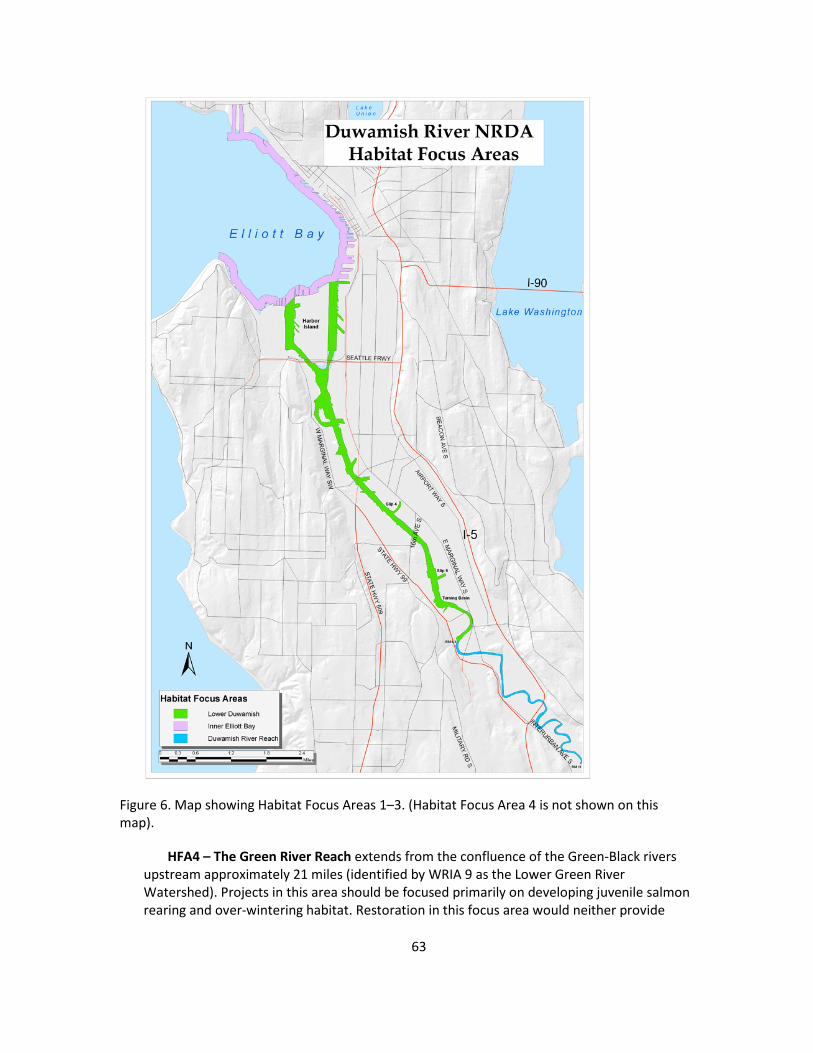
Figure 6. Map showing Habitat Focus Areas 1–3. (Habitat Focus Area 4 is not shown on this map).
HFA4 – The Green River Reach extends from the confluence of the Green-Black rivers upstream approximately 21 miles (identified by WRIA 9 as the Lower Green River Watershed). Projects in this area should be focused primarily on developing juvenile salmon rearing and over-wintering habitat. Restoration in this focus area would neither provide
63

significant benefits to marine and estuarine species nor to the types of shorebirds located in the LDR.
Projects that restore habitat and natural resources within the LDR (HFA1) will receive top priority. As the nexus for the injury, restorations within the LDR will provide the most direct benefits to the whole suite of injured natural resources (including salmonids, marine fish, and birds). Projects outside of the LDR will still be considered, but will be valued less than those within HFA1 because of their distance from the injury. Restoration projects in HFA3 and HFA4 will only be considered if they are a component of a settlement proposal that includes restoration in the LDR (HFA1) and will also be subject to restrictions regarding minimum size and project type.
64
7. RESTORATION TYPES
An overall guiding principal for an ecosystem-based approach is to prioritize larger, more integrated projects that sustainably restore or enhance ecosystem processes and that are closely linked to the injury nexus. Larger projects that are well integrated into the landscape are more likely to support diverse habitats and species. For example, a larger project in HFA1 could incorporate low and high marsh habitat as well as vegetated upland buffers, and therefore support aquatic and terrestrial species (Figure 5). Projects that sustainably restore or enhance ecosystem processes are more likely to endure for longer periods of time without active maintenance and are more likely to adapt to changes in the environment, such as those that may result from climate change.
Successful restoration projects share certain attributes that contribute to their long-term sustainability. The six attributes described here were developed specifically for the LDR. Restoration projects under NRDA that include some or all of these elements will receive extra value and/or higher priority for selection, though Trustees will make final decisions on whether to accept a site after considering all the project specifics.
1. Overall size – In general, larger projects are preferred because these projects can incorporate more types of habitats, can support a more diverse assembly of species, and will likely be more resilient to stressors and climate change.
2. Shape of the project – Shape includes the geometry of the habitat, the orientation of the habitat to the river (i.e., parallel or perpendicular), and the width of any openings for channels. The preferred project shape will vary depending on the type of habitat being restored and whether it is located along the main channel or a side channel of the river. More information about shape is incorporated into the description of desired restoration types in Section 7.1.
3. Habitat type – Restoring or creating habitats that help replace lost estuarine and aquatic services are prioritized, such as marsh and mudflat. Also valued are habitats that are highly important to key organisms, such as threatened or endangered species, and habitats that have become scarce in a given part of the river. More details on desired habitat types are provided in Section 7.1.
4. Diversity – Projects that support several ecological niches as well as a diversity of species are preferred. Projects that support an array of habitats are more likely to have larger numbers of niches and species.
5. Location in the river – This attribute includes historic location for similar habitat, access and use by multiple species, societal/cultural factors, and potential for contamination. Commonly, restoration projects attempt to return an area back to its historical habitat condition; because the Duwamish River has been so drastically altered, NRDA projects will have to consider the types of habitats that were historically present in the lower river and where these habitats can now occur given current ecosystem processes and physical constraints. For example, transitional habitat where saltwater and freshwater
65

mix extends further upriver today than it did historically. This change was caused by reduced freshwater flow into the estuary and the presence of the deep navigation channel.
Projects may also be more or less desirable due to societal/cultural factors. Projects, especially those close to residential areas, might provide increased recreational opportunities or enhance the aesthetics of neighborhoods. Public access must be balanced with safety concerns for a particular site as well as potential negative impacts of overuse that might discourage some wildlife species or degrade habitats. As a result, some sites may provide more benefits by incorporating public access while others may not be appropriate for access. In addition, the selection and construction of restoration sites must also take into account the cultural consideration of tribes such as archeological artifacts or culturally important sites.
Selection of projects and the determination of their benefits must also include an examination of residual on-site or potential off-site contamination sources. Contamination of restored habitat may reduce the ability of that system to recover to a functional state and could negatively impact the species that use the site. Clean-up of contaminated areas would be completed as part of or prior to the implementation of the restoration project.
6. Landscape connectivity – Landscape connectivity is closely related to the location attribute. Restoration projects benefit from interconnections between habitats. These connections create wildlife travel corridors and enable the restored ecosystem to exchange materials and energy (seeds, nutrients, and biomass) throughout the ecosystem. Creating viable habitat corridors along the river provides the necessary biological requirements for fish and wildlife using the river, Elliott Bay, and Puget Sound.
Projects that are located immediately adjacent to existing habitat will generally provide more ecological services than projects isolated from existing habitat. Connecting existing and restored habitats creates a larger overall habitat area and increases the transport of plants and animals to the newly restored site. Because the LDR has lost such significant amounts of natural habitat, it is also important that habitat restoration be located at regular intervals throughout the LDR. Habitat that is spaced at regular intervals will provide juvenile Chinook salmon with the opportunities to forage, find refuge, and osmoregulate during their lengthy seaward migration. Off-channel and side channel habitat are especially needed in the LDR.
Other important considerations related to functional uses of habitats by injured resources and their long-term sustainability include whether projects are located in the river’s transition zone or in off-channel habitat.
Habitats in the River Transition Zone
The transition zone is the area where freshwater and saltwater mix, resulting in brackish conditions. The LDR (HFA1) encompasses most of the transition zone; the Duwamish River Reach (HFA3) contains the southern end of the transition zone during certain conditions (low freshwater flow and high tidal reach).
66

Recent studies have documented the importance of the transition zone in the Duwamish River for use by juvenile Chinook salmon (e.g., WRIA 9, 2006b). The transition zone is where juvenile salmon osmoregulate so they can survive in the saline conditions of Puget Sound. Historically the transition zone was a wide swath of marshes located further downstream; today it is greatly reduced in size and complexity with far fewer off-channel habitats. Because of its critical role for supporting a key life stage of salmon and its potential to become a hindrance for salmon recovery, the transition zone is a prime focus of WRIA 9 recovery efforts. Several restoration projects have already been established in this zone, and locating additional projects in this zone or near the existing projects may be particularly valuable.
Off-channel habitat
Historically, the LDR contained numerous small streams, oxbows, dead-end sloughs, and connected wetlands that provided off-channel habitats. These habitats allowed for easier downstream migration of salmon by providing staging areas for acclimation, feeding, and resting away from high water flows and large predators. They also provided isolated refuge for birds, access to water for wildlife, and overall habitat for a more diverse assemblage of species. The scarcity of these habitat features limits efforts to maintain or enhance injured fish populations and other natural resources. Creating off-channel sloughs, lagoons, and dendritic channels serves many of the NRDA target species (salmonids, flatfish, invertebrates, and birds). Off-channel habitat in the transition zone is particularly important to the recovery of Chinook salmon because the zone supports a key Chinook life stage. Existing off-channel habitat cannot fully support both the natural origin and hatchery fish.
7.1 Desired Types of Restoration
The Trustees are interested in restoring habitats that substantially contribute to marine and aquatic resources impacted from contamination of the river. Marsh and mudflat restoration are top priories in the NRDA effort. Also important are riparian buffers, especially those adjacent to marsh habitat. Riparian habitat supports wildlife and the ecological connection between the land and the river. Riparian habitats filter runoff and provide sources of organic material into the river. Restoration of mudflats, intertidal marshes, and riparian habitats will also benefit the larger marine system of Puget Sound and the species that inhabit that system such as Orca whales and other marine mammals and top-level predators. The NRDA habitat priorities directly contribute to the larger ecosystem through the food web; primary, secondary, and tertiary productivity; nutrient cycling;, and more natural sediment inputs.
The Trustees will entertain other project types for inclusion under the NRDA. However, clear and specific benefits to injured natural resources must be shown. The restoration of mudflats, marshes, and riparian buffers is the primary focus of the Trustees for the NRDA process because these have been determined to have the most direct benefits to injured resources following clean-up of the river. The description below for the creation of these habitat types in the LDR is based upon the experience of Trustees on other restoration projects in the Duwamish and elsewhere in Puget Sound and the input from experts.
67

7.1.1 Creation of Intertidal Mudflat
Intertidal mudflats are defined here as those habitats that occur within the tidal range of -4 and +12 feet mean lower low water (MLLW). This includes low intertidal mudflats between -4 and +4 feet MLLW as well as high intertidal mudflats between +4 and +12 feet MLLW. Intertidal mudflats in the LDR support a variety of benthic and epibenthic communities that are important food sources for fish—including juvenile Chinook salmon—and birds. Mudflats that are a part of a side channel also serve as important resting areas for juvenile salmon, including Chinook. Construction of mudflats also provides direct benefits to other species such as English sole.
Constructed mudflats should have a relatively shallow grade of less than 2 percent of unvegetated silt/clay to fine sand substrate. Ideally, restored mudflats would have a width (distance perpendicular to either the main or side channel) of at least five meters. Where possible and appropriate, mudflats should be constructed to border existing or restored marsh or vegetated buffer habitat. Because of the use of the LDR for navigational purposes, most restoration projects that include restored mudflats will need to cut into the existing riparian bank to create the appropriate tidal elevations for additional mudflats. Where the appropriate mudflat elevations still exist, construction activities may involve a less extensive bank cutting and site regrading to create the elevation gradient from mudflat up to low and high marshes. In some locations there may be a combination of cutting into the bank as well as filling in lower reaches to achieve the -4 to +12 mudflat elevations. Appropriate sediment grain size fractions and total organic carbon content may need to be added to restored mudflats. In addition, any derelict vessels, trash, or rubble located within the intertidal mudflat range will be removed during the course of construction.
7.1.2 Creation of Marsh
Marsh habitats include both low marsh that occurs between +5.5 and +10 feet MLLW and high marsh that occurs between +10 and +12 MLLW. Both the low and high marsh habitats experience regular tidal inundation and are vegetated with vascular plants. The vegetation of the marsh habitat and its primary productivity are key components of an estuarine food web. Primary productivity and the resulting secondary productivity influence the structure and abundance of the epibenthic and benthic communities, the ability of the marsh to serve as an adequate refuge, and the foraging habitat for salmonids and other fish and wildlife species.
High and low marsh habitat can be constructed on either the main channel or as side channels off of the Duwamish River. Side channel habitat will be more protected from boat wake and other related disturbances within the mainstem channel. Off-channel or side channel habitat also provides more of a refuge for juvenile salmon than habitats in the mainstem because they are subject to reduced currents.
The sustainability and ecological value of restored marsh habitat will depend, in part, on its size and depth (distance perpendicular to either the main or side channel). Judgments about these sizes and depths can be formed by observing systems of similar size in the Pacific Northwest. High marshes along the main channel would ideally be at least 10 meters deep and low marshes at least three meters deep and 10 meters long. Marshes greater than 10 meters deep may start to form multiple small drainage channels which provide important areas for fish
68

foraging. Side channel high marsh habitat preferably would be at least three meters deep and low marsh habitat at least two meters deep, because these are more protected from disturbance regimes. Creation of marsh habitat will have an increased value if it contains both low and high marsh habitat as well as adjacent vegetated buffers and/or mudflats. Restored marshes that are adjacent to existing marsh habitat will also have greater value.
As with intertidal mudflats, marshes may be constructed in many portions of the LDR main channel by cutting into and regrading the existing upland to restore a marsh elevation and lower gradient slope. If the area of the marsh is deep enough, drainage channels may be constructed or allowed to form naturally. For off-channel habitat, existing tributaries could be enhanced by more natural marsh elevation, increased channel sinuosity, and additional native plantings. Side channels could also be created by removing fill or digging into upland habitat to create a side channel and its associated marsh and upland habitats. Side channels should be constructed to have a high level of shading to maintain cooler water temperatures and retain water during low tides so that fish can remain in these habitats for longer periods of time. The location of relic marsh sediments that would be uncovered when removing fill to create marsh can be used as a guide in helping to develop the marsh restoration plan, because these sediments contain the appropriate amount of organic matter and are at the appropriate elevation for marshes.
Marsh creation may also entail the placement of large woody debris to increase habitat complexity. Marshes should be well planted with native species to reduce time to full ecological function and prevent the establishment of invasive species. High marsh communities should contain a variety of herbaceous species such as Deschampsia, Atriplex, Distichlis, and Potentilla as well as appropriate shrubs such as willows and dogwood. Low marsh vegetation communities are dominated by herbaceous species, in particular Carex species. Dense vegetation communities in marshes will support insect inputs to the river and terrestrial wildlife habitat.
7.1.3 Creation of Riparian Habitat
Vegetated riparian habitats occur sporadically along the Duwamish River from its mouth up through the Green River, although they are greatly reduced or absent for some stretches of the riverbank in the urban areas. Riparian habitats have an elevation of +13 feet MLLW or higher and contain a mixture of native scrub/shrub vegetation and trees that range from water-tolerant species such as willows and Sitka spruce to more upland species such as hemlock, Douglas fir, salal, and Oregon grape. Many other native plant species have been used successfully in restoration efforts on the Duwamish and these will also be considered for use in riparian restoration projects.
Construction or restoration of upland habitat is most beneficial to LDR injured resources when it is adjacent to either restored or existing marshes, mudflats, or creek tributaries. These riparian habitats can dampen noise and filter stormwater runoff flowing into the wetland habitat and exchange materials and energy with adjacent marsh systems. Placement of riparian areas next to marshes increases the ability of multiple species to use both habitat types, such as birds that may perch in the larger trees and bushes and forage in the marsh and river system. Riparian habitats that are not located adjacent to restored or existing marshes, mudflats, or tributaries provide reduced ecological benefits to injured resources. The width of a restored riparian area will influence the integrity of the habitat and its ability to support wildlife. Riparian
69

habitats should ideally be over five meters in width with larger areas providing more ecological benefits.
Restoration of riparian upland may include removal of invasive species, removal of bank armoring or other debris, re-grading the site, planting native vegetation, placing wood, and enhancing substrate. In some cases restoring riparian habitat may consist of enhancement actions such as planting willow stakes in a rip-rap shoreline or just behind it to create overhanging vegetation (known as willow whipping rip-rap). This helps shade the river or side channel and provides insects to the river. In cases where rip-rap is needed as a transition between a restored site and an adjacent bulkhead, this lessens the negative impacts of rip-rap. These types of activities provide some benefit but are significantly less valuable than complete removal of armoring and planting.
7.1.4 Potential Restoration Construction Actions
In addition to the specific construction actions listed above for intertidal mudflat, marsh, and riparian habitat restoration, projects under the NRDA process may include, but are not limited to, the following activities (specific restoration actions will vary by the site and the goal of the project):
• Re-grading slopes to create elevations suitable for mudflats, intertidal marshes, and establishing upland vegetated buffers.
• Re-creating off-channel habitats, such as side channels, through excavation.
• Removing artificial debris, including creosote pilings, bank armoring, derelict vessels, and old piers and docks.
• Incorporating natural debris, such as logs and root wads.
• Enhancing substrate of riparian, marsh, or mudflat habitats.
• Planting adjacent uplands to provide riparian habitat appropriate for fish and wildlife, including willow whipping rip-rap armoring that cannot be removed.
• Removing invasive species and planting native species in all target habitat types.
• Reconnecting freshwater sources to the Duwamish River.
• Increasing connectivity between existing and enhanced habitat components.
The removal of previously placed fill material, structures, shoreline armoring, and debris that will occur during these restoration efforts can be challenging, and some unanticipated difficulties will occur for some projects.10 Careful site assessment investigations will help reduce the likelihood of unexpected problems, but some projects may need to be modified because of such discoveries.
10 For example, NRDA restoration projects implemented in the LDR to date have encountered unexpected problems such as underground storage tanks, previously unknown cultural resources, and large amounts of debris that resulted in extra disposal costs.
70
7.2 Types of Restoration Not Desired
NRDA restoration projects must benefit natural resources that have been injured as a result of releases of hazardous substances into the LDR in order to fulfill the Trustees’ mandate under CERCLA to make the public and environment whole. This relates to the type of restoration as well as the location of the restoration projects in relation to the injured resources and services. Beyond that, practical considerations such as the amount and cost of actions necessary to maintain a project are important considerations. Restoration actions that do not fulfill the Trustees’ mandate to restore injured resources or which would be difficult and/or costly to maintain are not appropriate as NRDA restoration for the LDR. Information on screening criteria for projects is given in Section 8.2. Projects that will not be considered in the NRDA process include but are not limited to:
• Those located outside of the pre-defined HFAs.
• Those within the HFAs that do not benefit injured resources. For example, projects within the Green River Reach (HFA4) that only benefit terrestrial species that do not use the LDR.
• Activities that only provide benefits to adjacent human communities and not to natural resources or habitats.
• Upland restoration projects without a direct tie to the LDR.
• Projects that do not restore natural ecosystem processes.
• Projects that are not sustainable or require an inordinate amount of care and maintenance.
7.3 Restoration Project Monitoring and Performance Criteria
Monitoring is a critical component of any restoration project. Monitoring provides a mechanism to determine whether the project has met its goals or performance criteria and helps to guide adaptive management actions and site maintenance. Monitoring plans must be tailored to specific restoration sites and reflect the project’s goals and objectives. The parameters selected for monitoring should, where possible, also be ones that can be used collectively to evaluate restoration actions across the LDR. Collective evaluations of results from multiple restoration sites will allow the Trustees to evaluate the overall benefits from the NRDA restoration process and will help to inform future decisions and designs for projects.
7.3.1 Performance Criteria
Performance criteria are the measures that will assess the progress of the restoration sites toward project goals. Performance criteria should include both the performance anticipated as well as the time that is predicted for the restored habitat to reach intermediate milestones and the overall project goals. Because habitats and ecosystem processes can take up to 20 years, if not longer, to recover fully, intermediate milestones are necessary to determine whether a project is on an acceptable trajectory toward full recovery. Comparison to reference sites will
71
help set anticipated milestones and goals for project performance. For PRP-implemented projects, all performance criteria and monitoring plans must be reviewed and approved by the Trustees before site construction can begin.
7.3.2 Adaptive Management
Restoration is a relatively young science. To ensure the success of a restoration site it is important for all projects to have an adaptive management strategy that will allow Trustees to determine what attributes are not on target for project success and what actions, including overall course corrections due to site conditions, need to be taken to achieve project success. Adaptive management actions may include replanting species, changing plant species or densities, adding mulch or further amending soils, adjusting or augmenting herbivore exclusion devices, and/or installing irrigation. The Trustees will consider lessons learned from previous restoration efforts on the LDR—including past practices to avoid—when initially developing restoration concepts and after construction when evaluating whether (and what kinds of) adaptive management actions are appropriate. For PRP-implemented projects, adaptive management plans that detail potential restoration or management actions for a site must be reviewed and approved by Trustees prior to project implementation.
Monitoring parameters should be designed to inform adaptive management actions. Monitoring data collection and analysis is critical in the first few years of site development, as that is the time during which management actions are most effective. Eradicating or controlling invasive species before the population is too large or planting different species because the hydrology or salinity of the site is different than what was originally anticipated are examples of adaptive management actions.
The key to a successful adaptive management plan is the critical evaluation of a problem or attribute that is not performing as expected. This critical analysis before actions are taken helps to ensure that issues are properly addressed and adaptive measures successful. For example, if there is a large die-off of certain plant species, managers should first evaluate potential causes. Was it poor plant stock? Unexpected salinities or hydrologic regimes? Or perhaps herbivore pressure? If the stock was poor, the same species could be successfully replanted. If the die-off resulted from a salinity change, different species should be planted that can tolerate the new salinity regime. Protective structures such as goose-excluder netting or roping can be constructed if herbivore pressure becomes too high.
7.3.3 Monitoring Parameters
The specific parameters being monitored should reflect both the physical structure and biological components of the restored habitat. More importantly, the selected parameters and plan must assess how the system and its ecological processes are functioning. For example, monitoring a low marsh and mudflat restoration might include an examination of how the benthic and epibenthic communities that support larger food webs are developing in relation to healthy systems. One might also examine how juvenile salmonids and birds are using the site; is it for resting and/or foraging? Examples of potential monitoring parameters include:
72

Physical parameters
• Intertidal area, including area of low and high marsh and mudflats.
• Slope stability and erosion.
• Soil/sediment structure and quality.
• Site salinity.
• Sediment accumulation patterns.
• Channel development.
• Tidal regime and circulation.
• Surface elevation gradients and channel morphology.
Biological parameters
• Vegetation survival and areal coverage.
• Herbivore control effectiveness.
• Invasive species cover and presence.
• Presence of desired fish and wildlife species.
• Fish or wildlife use of site.
• Food web structure.
• Benthic community structure.
• Primary productivity levels.
• Composition of insect fall-out.
Many ecosystem processes and restored habitats take time to fully develop. Monitoring should be conducted for a minimum of 10 years at each site to effectively capture how the system is functioning and whether it will achieve its desired goals. Sites develop more rapidly at first as plants become established and the species return, and then have a slower recovery rate. As previously mentioned, adaptive management actions can be more effective earlier in the restoration process. To account for this temporal variability, monitoring should be completed every year for at least the first three years and can then be spaced more infrequently in subsequent years.
7.3.4 Reporting Requirements
An as-built construction plan must be submitted to the Trustees after completion of construction. Monitoring plans along with identified adaptive management actions that need to be taken must be completed once a year for the first three years and according to the approved monitoring schedule thereafter.
73

7.4 Stewardship Model
The LDR is situated in a dense urban environment. The river and its estuary are highly altered with many ecosystem processes no longer fully functioning to support healthy habitats. Many habitats have an altered hydrologic regime because they have been cut off from ground water or surface water flows. Loss of riparian and marsh habitats have increased sediment and pollution inputs from reduced filtration and other attributes and reduced inputs of detritus matter and wood. Habitats in urban environments are also subjected to increased disturbance levels such as the establishment of invasive species, negative human impacts such as dumping or trampling, and increased herbivore pressures on young plants.
These stressors can slow or in some cases prevent restoration projects from achieving the desired long-term benefits to injured resources. Vegetation is likely to require irrigation and, for marsh plants, goose-exclusion fencing in order to become established successfully. In addition to adaptive management, long-term stewardship that includes site monitoring and maintenance activities will help ensure that NRDA restoration actions are able to provide the required long-term benefits to injured resources. Each NRDA settlement will include a period of required monitoring and adjustments to ensure the successful establishment and functioning of the habitat. In addition, a mechanism will be established by the Trustees to help ensure long-term stewardship of all NRDA sites in the LDR to come into effect after the period of active maintenance is complete. A long-term stewardship program is being developed for Commencement Bay NRDA restoration projects and is being considered for the Elliott Bay/Duwamish River Restoration Program, and the Trustees anticipate following a similar model for LDR restoration projects.
Stewardship is a combination of a monitoring and maintenance activities. Yearly inspections of restored sites will inform the site stewards as to what actions, if any, will need to occur over the course of a year. Potential management actions include:
• Invasive species removal and/or control.
• Removal of debris or trash.
• Planting vegetation, including species that require shade from a more established canopy and therefore could not have been planted immediately after construction.
• Mulching or soil amendments.
74

8. PROJECT SELECTION
8.1 Summary of Other Restoration Plans
In addition to this Restoration Plan and Programmatic EIS, several other restoration plans have been developed in the Duwamish River:
Puget Sound Salmon Recovery Plan, Water Resource Inventory Area (WRIA) 9, Green/Duwamish River Basin, 2005
The Puget Sound Salmon Recovery Plan section for the Green/Duwamish River includes watershed implementation priorities over the next three years. Of 35 projects identified (including nearshore Elliott Bay), six projects are located in the LDR focused on estuarine transition zone habitat.
U.S. Army Corps of Engineers Green/Duwamish River Basin Ecosystem Restoration Study, 2000
This plan covers the entire Green/Duwamish watershed (upper, middle, and lower), and proposes 45 restoration projects. Five of these proposed projects are located in the Duwamish estuary, with the remainder in the Green River and its tributaries. Duwamish Project One (now known as North Winds Weir, located in HFA1) was completed jointly with King County in 2010 (http://www.govlink.org/watersheds/9/plan-implementation/SRFB-northwinds.aspx). Project Codiga Farms, located in HFA3, was constructed in 2008 (http://pugetsound.org/science/projects/central/codiga.pdf).
Elliott Bay Panel, Elliott Bay and Duwamish River, 1994
The 1994 Concept Document of the Elliott Bay/Duwamish Restoration Program was the result of a consent decree signed in 1991 between the Elliott Bay Trustees, METRO (now King County) and the City of Seattle, to address natural resource damage liability (EBDRP 1994, 1996, 1997; U.S. District Court, 1994). The purpose of the Concept Document was to identify and evaluate potential sites for remediation and habitat development (restoration) to compensate for injuries in Elliott Bay and the Duwamish River estuary. The consent decree parties formed a Panel to carry out the program objectives. The Panel was involved in 11 projects, including three remediation projects and a recontamination study. Of the habitat projects, five are located in the LDR (Hamm Creek, Site 1 (now North Winds Weir), North Winds Weir/Cecil B. Moses Park, Turning Basin #3/Kenco Marine, and Herring’s House). The Panel has directly restored fish and wildlife habitat in its focus areas. In addition to contributing funds to the construction of habitat sites by others, they directly restored fish and wildlife habitat at four Panel restoration sites in the LDR. Three of these Panel Habitat projects are summarized in more detail under section 8.3. Examples of Already Completed Restoration Projects.
Lower Duwamish River Habitat Restoration Plan—An Inventory of Port of Seattle Properties, 2009
This plan by the Port of Seattle inventories port properties and suggests possible restoration opportunity sites that could be candidates for restoration projects. The plan also describes
75
existing habitat restoration projects that the port has already completed (Port of Seattle, 2009b).
Duwamish Valley Vision Map and Report, 2009
The Duwamish River Cleanup Coalition produced this visioning document after holding a series of community meetings around future ideas for the Duwamish Valley. The report looks at economic development, transportation amenities, and environmental features. Various habitat projects and open space concepts are included in the Environmental Features section, including a habitat corridor along the South Park Shoreline (Duwamish River Cleanup Coalition, 2009).
8.2 Selection Criteria
Potential restoration sites will be identified by Trustees, PRPs, other government agencies, private firms, and the public. Initial screening will assess the site and its suitability for restoration. For example, if a proposed project is not located within one of the HFAs, it would not be evaluated further. A project within a HFA would merit further screening if it is determined to have the potential to benefit injured natural resources and services, but would not be considered further if it did not have such potential. Once a site is proposed, a project-specific restoration concept will be developed. This will determine what restoration is possible at the site and how it can be carried out, and will include site-specific goals. Based on these goals, specific restoration techniques will be designed and preliminary cost estimates prepared and compared with available funding. During the project design and implementation, Trustees will take advantage of opportunities to partner with other agencies or utilize economies of scale to reduce costs or improve project benefits where feasible.
Sites will be evaluated using a two-step process. For the initial screen (Tier 1), proximity to the affected area, potential to benefit injured natural resources and services, and future management will be considered. Sites that meet this initial screen will then be examined under Tier 2 criteria that are designed to focus on differences between sites and enable prioritization of potential sites.
Tier 1 Screening:
Habitat Focus Area
Is the potential site located within the higher priority HFA?
Benefits to Injured Resources
How similar are the habitats being created or enhanced to the natural resource injuries and service losses that resulted from the contaminant impacts? Projects that most directly benefit the resources and services that were injured will receive highest priority.
76

Future Management
Would the landowner agree to a conservation easement or other appropriate land management restriction? Without an understanding of the future management of the specific property under consideration, the Trustees cannot estimate future service flows, and therefore will not further consider the site.
Tier 2 Screening:
Technical Feasibility
What site-specific factors might influence project success? This includes residual contamination that may adversely affect resources and whether there is adequate acreage available for project implementation.
Cost to Carry Out the Restoration Alternative
What are the costs associated with implementation of the restoration project at the proposed location? This includes costs to purchase property or acquire appropriate easements, and costs for implementation. Everything else being equal, projects that cost less than other alternatives are preferred.
Source Control and Recontamination Potential
Is there adequate source control so that a restoration project will not be contaminated by new releases of hazardous substances? What is the likelihood of recontamination of a project site by hazardous substances from surrounding sediments? The Trustees do not want to build habitat projects that will become significantly contaminated such that resources utilizing the project sites would be injured. This may mean, for example, that a project would either not be built if there is a high potential for it to be contaminated or its construction would be delayed until adequate source control and clean-up of nearby and upstream contaminant sources is completed.
Extent to Which Each Location Will Maximize Benefits to Resources
Under this criterion, specific features of the site location, habitat type to be created, size of the project, location in the river, and proximity to other restoration sites will all be evaluated to determine benefits to resources. For example, if the site is located close to an existing restoration site, it may provide added benefit by increasing the habitat complexity of an area. This evaluation will rely on guidelines described in Section 7.
8.3 Examples of Restoration Projects from previous settlements
As a result of a NRDA settlement from 1991, the Elliott Bay Restoration Panel constructed several projects in the LDR. These projects are described in Appendix B and provide examples of the types of restoration projects that would be desirable for future settlements in the LDR.
77

Blank Page
9. RESTORATION ALTERNATIVE ANALYSIS
Relatively few types of restoration actions have proven over time to be reasonable approaches to restoring injured natural resources and services. The Trustees involved in CERCLA NRDA restoration in Commencement Bay faced a similar situation as that in the LDR, in terms of hazardous substances released and the types of natural resources that were injured. They underwent a detailed review of potential restoration approaches, and this analysis is presented in their Restoration Plan/Programmatic Environmental Impact Statement (RP/PEIS, Commencement Bay Natural Resource Trustees, 1997). Their review of restoration approaches (available at: http://www.cbrestoration.noaa.gov/docs.html) is incorporated into this LDR PEIS by reference. Three of the Commencement Bay restoration alternatives—two action alternatives and the no-action alternative (which must be analyzed under NEPA)—were chosen for further evaluation by the Trustees for this LDR NRDA Restoration Plan.11
The three restoration approaches proposed for analysis for the LDR are:
• Alternative 1: No Action
• Alternative 2: Species-Specific Restoration
• Alternative 3: Integrated Habitat Restoration
Restoration alternatives must be appropriate for NRDA restoration under CERCLA as an initial analysis and then must be analyzed for direct, indirect, and cumulative impacts under the National Environmental Policy Act (NEPA). The process used in this analysis is first to evaluate how well the alternative meets the goals of restoration under CERCLA. Alternative 1 was determined to be inconsistent with the Trustees’ obligation under CERCLA to restore natural resources and resource services that were injured or lost as a result of releases of hazardous substances. The remaining two alternatives would be consistent with CERCLA restoration goals, but Alternative 3 was judged to be more appropriate as a NRDA restoration approach than Alternative 2.
It is worth noting that the Commencement Bay trustees proposed a different restoration approach for NRDA restoration in their RP/PEIS—which they termed the “Integrated Approach”—that was a combination of all of the action alternatives they considered, including what they termed the “Habitat Function” approach. However, all the restoration actions actually conducted by the Commencement Bay trustees following the finalization of their RP/PEIS belonged to their Habitat Function category (which is the conceptual equivalent to the
11 The other two action alternatives considered by the Commencement Bay trustees included "Acquisition of Equivalent Natural Resources and Services" (natural resources or services which would be the same or substantially similar to the natural resource or service that was injured but could not otherwise be restored) and "Integrated Approach" (combination of all four action alternatives considered by the Commencement Bay trustees). For the LDR NRDA, the Trustees believe that restoration of the injured natural resources and services is possible, so the Acquisition of Equivalent Natural Resources and Services was not further considered. The Integrated Approach is discussed further in the text.
79
Integrated Habitat Restoration approach in this RP/PEIS) and no projects were from other categories included in their Integrated Approach Alternative. Therefore, the actual restoration actions that will result from implementation of the LDR preferred alternative, if it is selected when the RP/PEIS is finalized, will be similar to those that have been so successful in restoring injured natural resources in Commencement Bay and its associated waterways. The Trustees are confident that restoration in the LDR under the Integrated Habitat alternative would be equally successful.
9.1 Analysis of the Alternatives for the Purposes of Restoration
NEPA requires that any federal agency proposing a major action (as defined under NEPA) consider reasonable alternatives to the Proposed Action. Screening criteria are used to determine whether an alternative is reasonable. The Trustees used three criteria to evaluate the three alternate approaches on their ability to fulfill the Trustees' requirements under CERCLA and other statutes to restore injured natural resources and services in the LDR:
• Likelihood that the Trustees' goals in fulfilling their requirements to restore injured natural resources would be achieved.
• Potential to provide benefits to multiple natural resources and services.
• Potential for environmental impacts.
The three Alternatives are discussed below with respect to these criteria and other considerations. Table 3 summarizes the comparison of Alternatives.
9.1.1 Alternative One: No Action
The No-Action Alternative would result in the Trustees not working to restore natural resources and services that were lost as a result of the release of hazardous substances into the LDR. While there would presumably be an eventual recovery of affected resources to or near to the baseline condition that would exist if these releases had not occurred, there would be no restoration actions taken to compensate for interim losses that occurred in the past and are occurring now and will continue to do so until the recovery to baseline occurs. This would mean that the Trustees’ mandate under CERCLA to make the public and environment whole for injuries to natural resources from the releases of hazardous substances would not be met. This alternative does not address the purpose and need for restoration of lost natural resources and services, and therefore is not a preferred alternative for the LDR/NRDA restoration plan.
If this alternative was selected, the Trustees would not undertake any LDR/NRDA restoration projects. Any restoration actions in the LDR would take place under other current or future programs and regulations pursued by tribes, federal and state agencies, and other entities outside the NRDA process.
While short-term negative impacts are expected to continue under no-action as interim losses continue, the No-Action Alternative would have no direct, indirect, or cumulative adverse or beneficial impacts to the human environment as compared to the action alternatives. This is due to the fact that no new restoration actions are implemented under this alternative to
80

improve water or sediment quality, habitat conditions, and fish and wildlife including threatened and endangered species. The No-Action Alternative is by far the least costly alternative. However, the No-Action Alternative is not consistent with the goal under CERCLA to restore natural resources and services that were injured or lost as a result of the release of hazardous substances. Because interim losses of natural resources and services have occurred and continue to occur during the period of recovery, and technically feasible alternatives exist to compensate for these losses, the Trustees determined that restoration actions are required, and the No-Action Alternative is not proposed as the Preferred Alternative.
9.1.2 Alternative Two: Species-Specific NRDA Restoration
This alternative would consist of planning and implementing individual NRDA restoration projects to benefit specific species or small groups of species that are likely to have been injured by hazardous substance releases to the LDR. Under this alternative, Trustees would evaluate potential restoration projects for the benefits provided to a specific species or group of species, without the organizational framework provided by the preferred Integrated Habitat Restoration Alternative (discussed below). Under the Species-Specific Alternative, Trustees would decide what species or group of potentially injured species would be targeted to benefit from a restoration action at a given time. Because there are a large number of species that the Trustees believe were injured as a result of exposure to hazardous substances, the species targeted for restoration actions could be subject to change over time in order to achieve restoration for more of the injured natural resources. Potential projects would be evaluated based largely on the benefits provided to the then-targeted species, not on benefits to a broader range of species. Under this approach, there would be more flexibility in locating restoration projects, because some of the species affected could benefit from projects outside the Duwamish/Green River and Elliott Bay system.
The variety of possible projects would also be greater under the species-specific approach, because non-habitat projects such as artificial propagation could be selected, in addition to habitat projects. Species-specific restoration activities could include projects such as restoration followed by re-introduction of individuals, artificial propagation of populations, and enhancing fitness of the population through selective breeding. Actions under this alternative might involve constructing net pens or hatcheries; creating or enhancing feeding, rearing, or spawning habitat; constructing artificial reefs; seeding intertidal mudflats with clams or oysters; or constructing nest boxes or perches. The Species-Specific Alternative, and possible types of projects that could fall within it, are discussed in detail in the Commencement Bay RP/PEIS (available at http://www.cbrestoration.noaa.gov/rp-eis/rpeis702.pdf).
The Species-Specific Alternative has a moderate potential for short-term impacts to water and sediment quality, habitat conditions, and fish and wildlife species. The nature and type of impacts from habitat creation projects designed to benefit target species would be similar to those for the Integrated Habitat Restoration Alternative (Alternative 3). But other, potentially more significant kinds of impacts could result from non-habitat restoration projects. For example, longer-term adverse impacts to water and sediment quality could result from construction of new hatcheries, net pens, or aquaculture facilities.
81

From a NRDA perspective, a species-specific restoration approach would be most appropriate if one or a few species were predominantly injured by the oil or hazardous substance releases, because projects could be designed to address injuries to these most affected species. For example, sometimes a particular species or a few species suffer a very large mortality as a result of an oil spill compared to other resources, and in those cases the Trustees have sometimes implemented a specific project to restore that species or a few species. The NRDA restoration for the North Cape Oil Spill is an example of this approach, where specific restoration projects were developed to restore species such as lobster and loons (see http://www.darrp.noaa.gov/northeast/north_cape/restore.html for more details).
However, when there is a broad range of species affected with a number of different life histories, trophic levels, etc., as is the case for the LDR NRDA, a species-specific restoration approach is more difficult. Targeting restoration for one or a few species runs the risk of having non-targeted species getting little or no restoration benefits to address their injuries.
It is likely that the process of restoration project selection would take longer and be less efficient than for the Integrated Habitat Restoration approach, because of the additional time required to assess the multitude of different types of projects and project locations, resulting in delayed restoration and higher planning costs. This alternative would result in less predictability, because a large number of different types of restoration could be considered at a number of different locations.
The Species-Specific Alternative would also be problematic for PRPs who would like to propose potential restoration projects as part of a settlement of their NRDA liability, but who would not have very clear guidance on what types of projects and project locations would be favored by the Trustees. Additionally, scaling restoration actions for non-habitat projects would be more difficult than scaling habitat projects, because the assessment approach used by the Trustees to develop estimates of injury is based on impacts to habitats, weighted by their value to a large number of species, not on one or a limited number of species. A species-specific restoration approach would require Trustees to develop estimates of injury to individual species, which would be extremely difficult, time-consuming, and expensive in a situation like that in the LDR, in order to scale the individual restoration projects.
A very detailed analysis of impacts from this alternative is difficult, as there are many possible types of projects, with greatly differing potential impacts. Therefore the impact analysis of the species-specific alternative is discussed generally beginning in Section 9.2. The more-detailed analysis of this alternative in the Commencement Bay RP/PEIS is incorporated in this RP/PEIS by reference. The species-specific restoration alternative is not proposed as preferred for the LDR RP/PEIS, given that the injuries are believed to be broad-based and not predominantly to one or a few species, and that a different assessment approach would be required from what the Trustees have determined to be most appropriate under the circumstances in the LDR.
9.1.3 Alternative Three: Integrated Habitat Restoration (Preferred)
This alternative involves actions designed primarily to restore certain types of habitats that support a range of species. Under this alternative, the Trustees would focus on habitat projects
82
that benefit a suite of different species, using important surrogate species and groups to evaluate the benefits of potential habitat projects to injured resources. Under this approach, projects that provide benefits to a large number of potentially injured species would have greater value compared to projects that would tend to benefit largely one species or a small group of species. Typical kinds of restoration actions under this alternative include removal of intertidal fill to restore mudflats, marsh, and/or riparian habitats; creation of off-channel areas; removal of creosote pilings and overwater structures that shade habitats; and softening shorelines. These projects will create habitats that provide food, foraging, and resting areas for juvenile salmonids and other fish, shorebirds, and wildlife.
The Integrated Habitat Restoration Alternative should result in net improvement in water and sediment quality over the long term. Some habitat restoration actions would result in short-term adverse impacts, but these impacts can typically be minimized by using best management practices at a project level. Adverse impacts may include temporary increases in erosion associated with land disturbance, temporary increases in turbidity, temporary increases in noise from construction activities, and short-term increases in air pollution from construction equipment.
This alternative ties in well with the approach the Trustees used in estimating injury, which is based on habitat use and value to the surrogate species or species groups. By clearly laying out the types of projects that the Trustees favor, PRPs will be able to use these guidelines to develop potential project ideas for settlement discussions with Trustees. This will also allow PRPs to begin considering whether restoration actions can be integrated with response or remedial actions to save costs. Use of this alternative will be more efficient for the Trustees, because there will be a consistent set of criteria and a methodology for evaluating potential projects. This will result in lower process-associated costs, reducing costs to PRPs. It facilitates the establishment of a cash-out position for potential settlements, because there are existing habitat restoration projects in the LDR that match the types of projects that could be implemented as part of this restoration planning effort, allowing the development of a reasonable restoration cost estimate for construction, monitoring, adaptive management, and Trustee administrative costs.
This alternative is proposed as preferred because it is best suited of all the alternatives to fulfill the goal of NRDA under CERCLA to restore injured natural resources and services. It is specifically designed to improve habitats that function in support of multiple fish and wildlife resources, as well as the prey items of these species that reside in those habitats. Habitat restoration in the Duwamish River will provide indirect benefits to animals such as Orcas, even though they do not directly utilize habitats in the LDR. Since Orcas feed on fish and other prey that do depend on these habitats, they will benefit from increased biomass and lower contamination in prey items. In fact, part of the recovery plan for the distinct population segment of Southern Resident Orcas, which are now listed as endangered under the Endangered Species Act, includes habitat restoration to increase prey availability to Orcas (NOAA, 2008). The Trustees recognize the success of similar habitat restoration projects in the LDR by the Elliott Bay Panel and others, Commencement Bay, and elsewhere in Puget Sound, whether done in a NRDA context or not, and this alternative will build on those efforts. The potential impacts of this alternative are discussed at greater length below.
83

9.2 Direct, Indirect, or Cumulative Impacts of Alternatives under NEPA
NEPA regulations require the assessment of effects of an action, including direct and indirect effects (defined at 40 CFR 1508.8) and consideration of cumulative impacts as defined at 40 CFR 1508.7. Accordingly, each of the three alternatives identified above were evaluated to assess their direct, indirect, or potential for cumulative impacts on the human environment. In assessing the impacts, the context of the action is considered in several contexts—e.g., the society as a whole, the affected region and interests, and the locality. By assessing the direct, indirect, and cumulative impacts that could potentially arise from implementing each of the alternatives, the severity (intensity) of the impacts can be determined to support a comparison of alternatives. Since restoration actions are designed to be beneficial but may involve various temporary or long-term adverse impacts, both beneficial and adverse impacts are analyzed. This subsection is specifically provided to serve as the analysis of environmental consequences as required under 40 CFR 1502.16, including a more detailed analysis relative to specific resource areas, including biological, physical, aesthetic, socioeconomic, historic, and cultural resources.
As individual projects are proposed subsequent to this restoration planning process, each project will be evaluated to assess the significance of impacts in accordance with the NEPA context and intensity factors described in 40 CFR 1508.27, including evaluating the intensity of both the beneficial and adverse impacts under short- and long-term conditions. Therefore, to most readily support the future tiering to this document that may occur for analysis of environmental impacts associated with individual projects, this section analyzes the affected environment against those specific factors (40 CFR 1508.27(b)) in order to evaluate whether or not the alternatives would have a significant effect on the quality of the human environment. In addition, the potential impacts of the alternative were examined in keeping with NOAA Administrative Order (NAO) Series 216-6, Environmental Review Procedures for Implementing the National Environmental Policy Act (NAO 216-6).
The following definitions are used to characterize the nature of the various impacts evaluated in this EIS:
• Short-term or long-term impacts. These characteristics are determined on a case-by-case basis and do not refer to any rigid time period. In general, short-term impacts are those that would occur only with respect to a particular activity or for a finite period, or only during the time required for installation activities. Long-term impacts are those that are more likely to be persistent and chronic.
• Direct or indirect impacts. A direct impact is caused by a proposed action and occurs contemporaneously at or near the location of the action. An indirect impact is caused by a proposed action and might occur later in time or be farther removed in distance but still be a reasonably foreseeable outcome of the action. For example, a direct impact of erosion on a stream might include sediment-laden waters in the vicinity of the action, whereas an indirect impact of the same erosion might lead to lack of spawning and result in lowered reproduction rates of indigenous fish downstream.
• Minor, moderate, or major impacts. These relative terms are used to characterize the magnitude of an impact. Minor impacts are generally those that might be
84
perceptible but, in their context, are not amenable to measurement because of their relatively minor character. Moderate impacts are those that are more perceptible and, typically, more amenable to quantification or measurement. Major impacts are those that, in their context and due to their intensity (severity), have the potential to meet the thresholds for significance set forth in CEQ regulations (40 CFR 1508.27) and thus warrant heightened attention and examination for potential means for mitigation to fulfill the requirements of NEPA.
• Adverse or beneficial impacts. An adverse impact is one having adverse, unfavorable, or undesirable outcomes on the man-made or natural environment. A beneficial impact is one having positive outcomes on the man-made or natural environment. A single act might result in adverse impacts on one environmental resource and beneficial impacts on another resource.
The Trustees concluded overall that any potential adverse environmental impacts from the Integrated Habitat Restoration Alternative would largely be short-term and construction-related, while beneficial environmental impacts would result in long-term moderate increases in habitat benefits to the area’s natural resources and the aesthetics for humans. There would be direct beneficial impacts to habitat function and indirect beneficial impacts to the suite of species that depend on these habitats. The Species-Specific Alternative has a greater potential for adverse impacts in the short and long term than does Alternative 3 (as detailed in the Commencement Bay RP/PEIS), but also has the potential for long-term beneficial environmental impacts. Some of the potential projects under this Alternative could benefit one or a few resources, in contrast to the Integrated Habitat Restoration Alternative. The No-Action Alternative would have no direct impacts, adverse or beneficial, and would result in no additional restoration beyond that that would otherwise be accomplished under other programs and authorities. There would be no actions to offset the continuing loss and degradation of habitat in the LDR.
9.2.1 Likely Impacts of the Alternatives
As noted above, adverse environmental impacts expected from restoration projects under the Integrated Habitat Restoration Alternative are all short-term and construction-related. The magnitude of environmental impacts would generally be a function of the extent and duration of construction. Mitigation measures (i.e., use of best management practices) would be included to minimize these short-term impacts and would be considered on a project-by-project basis. Adverse impacts would therefore be expected to be minor. The long-term impacts would be beneficial to the area’s natural resources by, for example, providing additional fish habitat, protecting and improving water quality, and increasing aesthetics in the area. Although individual habitat restoration projects would provide relatively minor beneficial impacts, cumulatively the additional acreage of habitat from multiple projects implemented under the Integrated Habitat Restoration Alternative would be of more moderate impact given the severe lack of habitat in the LDR. Projects implemented under Alternative 3 would be developed to comply with all applicable local, state, tribal, and federal permits and approvals.
Adverse environmental impacts under a Species-Specific Alternative would be the same as those for Alternative 3 for those projects that are habitat-related, but also include other
85

potential adverse impacts from other possible types of projects that could be implemented under this alternative. Potential issues with aquaculture projects, for example, could include organic enrichment of sediment, and disease. These have the potential to cause more long-term and moderate adverse impacts, although mitigation measures might reduce the likelihood of such impacts. The Commencement Bay RP/PEIS discussed those other potential impacts in detail.
In contrast, the No-Action Alternative would have no such construction-related impacts, but neither would it have the long-term beneficial impacts to natural resources in the LDR.
9.2.1.1 Aesthetics, Light, and Glare During the construction phase of a project under the Integrated Habitat Restoration
Alternative, the project site would have poor aesthetics from disturbed soils, piles of debris, and other construction-related untidiness, resulting in short-term minor impacts. It is possible that lights might be used if some of the construction work is done at night (for example, to work when there are favorable tides). There could be some glare off of machinery used in the construction. However, the duration of this phase would be relatively short, a few weeks to a few months, for projects under this alternative. Following construction, project sites are likely to have much better aesthetics than were present prior to the restoration action, if for example rip-rap or other shoreline armoring is replaced with marsh and riparian vegetation.
The same is largely true for the Species-Specific Restoration Alternative. There would be no visual impacts from the No-Action Alternative.
9.2.1.2 Economic Impacts No significant economic impacts on neighborhoods would occur under the Integrated
Habitat Restoration Alternative. The restoration projects implemented under this alternative would not result in a significant conversion of commercial property to habitat that could lead to job losses or decreases in income for the jurisdictions in which these projects would occur. There would be short-term, minor economic benefits to local businesses in the general area in which habitat projects would be located from spending by construction workers. Over the long term there should be no significant economic impacts from the implementation of this alternative.
The same is largely true for the Species-Specific Alternative. The No-Action Alternative would have no economic impacts, including no short-term benefits to local businesses.
9.2.1.3 Energy and Natural Resources There are no known sources of energy or exploitable natural resources in the area to be
affected by either of the action alternatives; therefore, no impacts would result from implementation of either of these alternatives. No impacts would result from the No-Action Alternative.
86
9.2.1.4 Geological and Soil Resources There are no known mineral or oil deposits in the areas where projects under the Integrated
Habitat Restoration Alternative would be located, and many of the project sites will be developed/disturbed/filled-in areas, and construction of habitat will therefore provide a slight increase in the quality of soils and sediments. This is also true for habitat projects under the Species-Specific Alternative. There is a slight potential for long-term minor to moderate impacts to sediment from nutrient enrichment from aquaculture facilities if not properly constructed and maintained. There would be no adverse impacts to geological and soil resources from the No-Action Alternative.
9.2.1.5 Recreation and Education It is anticipated that many projects implemented under the Integrated Habitat Restoration
Alternative would increase the aesthetics of the shoreline in the LDR, replacing hard armoring with vegetated shorelines. Therefore kayaking or boating in the area would be enhanced over the long term by the creation of more natural habitat along the river. No adverse impacts to recreation or education would be likely under this alternative. It is possible that some project locations would be or would become parks that could have passive recreational use, provide access to the LDR, and/or possibly have information kiosks that could provide environmental education to visitors. Public use on any restoration project site would need to be carefully considered and designed in order to minimize any loss of potential ecological value, since offsetting ecological injuries in the LDR is the primary mandate for the Trustees. Therefore, although there would be some long-lasting beneficial impacts from projects implemented under this alternative, these would not be expected to be major.
Similarly, no adverse impacts to recreation or education would be expected from the Species-Specific Alternative. Since there could be more types of projects under this alternative, there may be more educational benefits from this approach than from the Integrated Habitat Restoration approach. But non-habitat projects would be less likely to provide recreational benefits to the same extent as habitat projects, so the recreational benefits from the Species-Specific Alternative could be less than from Alternative 3.
Under the No-Action Alternative, there would be no impacts, adverse or beneficial, to recreation and education. Any improvements in recreational use under this alternative would be related to those from other programs, and any adverse impacts to recreation would be those that would occur from developmental activities and changes in natural conditions.
9.2.1.6 Land and Shoreline Use The Integrated Habitat Restoration Alternative would result in minor impacts on land or
shoreline use since no existing uses are anticipated to be eliminated. In most cases, projects could be built along the existing shoreline or with rip-rapped or otherwise hardened banks pulled back without affecting existing non-water-dependent uses. On some areas where there currently is water-dependent use, it may be possible to build projects in such a way as to facilitate continued commercial waterfront activities. Property owners would need to agree to these projects, because the Trustees have no authority to force owners to allow such projects. Properties that are not currently being utilized would be prime candidates for use for habitat
87

development, especially if it is possible to create off-channel habitat. The conversion of currently unused land into habitat would remove these areas from potential future industrial development, but little property is anticipated to be available for purchase by the Trustees for restoration. Because existing uses on active properties are not expected to be altered as a result of this Alternative, and there is expected to be little opportunity to purchase property that is not being used on which to build restoration projects, the Integrated Habitat Restoration Alternative will not result in a large conversion of industrial/commercial property to habitat. As mentioned above, under this alternative it is possible that some of the projects may incorporate some additional passive recreational opportunities and so could increase public use of the LDR shoreline. This analysis generally applies to the Species-Specific Restoration Alternative as well.
Under the No-Action Alternative, any changes in land and shoreline use would be those that would occur from other programs and private activities, not from this Alternative.
9.2.1.7 Transportation, Utilities, and Public Services Under the Integrated Habitat Restoration Alternative there could be short-term, minor
impacts to transportation or utilities during construction of individual projects, although the impacts should be limited to small areas for brief time periods. Overall, implementation of Alternative 3 is not expected to increase demand for public services and utilities. Depending on the type of project, it is possible that the Species-Specific Alternative could result in some increase for public services and utilities, although any increase would be expected to be minor. The No-Action Alternative would have no impacts on transportation, utilities, and public services.
9.2.1.8 Wetlands The shoreline along most of the LDR is armored, and many former wetlands have been
filled, so relatively little wetlands remain compared to what was present historically. Implementation of the Integrated Habitat Restoration Alternative would increase somewhat the amount of wetlands in the LDR. The increase in wetlands from implementing this alternative would help offset any continuing loss of wetlands from other causes. It is likely that some wetlands would be a component of at least some habitat projects implemented under the Species-Specific Restoration Alternative. Under the No-Action Alternative, there would be no additional wetlands created except those created under other authorities and programs.
9.2.2 Likely Effects of the Alternatives on Public Health and Safety [40 CFR 1508.27(b)(2)].
As noted above, the adverse environmental impacts from the Integrated Habitat Restoration Alternative are all short-term and minor construction-related impacts and thereafter will provide long-term benefits to the areas’ humans and natural resources, while the No-Action Alternative would not benefit humans and natural resources. The Species-Specific Alternative has more of a potential for adverse impacts than Alternative 3, but none of these alternatives would be expected to have long-term or major impacts on public health and safety, as is discussed below.
88

9.2.2.1 Air Quality During the construction phase under the Integrated Habitat Restoration Alternative and
Species-Specific Restoration Alternative there would be minimal short-term increases in exhaust and dust from use of construction equipment. No major or long-term impacts to air quality would be expected to result from the implementation of projects. For projects in which vegetated habitat will replace rip-rap or structures, a minor improvement (expected to be unmeasurable) in air quality should result. The vegetation will also take up carbon dioxide, which will offset greenhouse gas emissions during project construction. There would be no impacts to air quality for the No-Action Alternative.
9.2.2.2 Environmental Health and Noise No long-term impacts to environmental health would be expected to result from projects
under the Integrated Habitat Restoration Alternative since analysis of future projects would include consideration of whether construction of a project could expose or mobilize contaminants, as described under the Tier 2 screening criteria (presented in Section 7.2). The selection of projects based on these criteria would avoid those sites with a high potential to expose workers or the public to contaminated soils and sediments. A health and safety plan would be in place to address any potential hazards during construction and all appropriate safety equipment will be used.
Project implementation under this alternative would result in short-term, moderate noise impacts in a small area around each project location from the use of heavy equipment during the construction phase of the projects. Outside of the immediate project area the increase in noise should be minimal. The same analysis is true for the Species-Specific Restoration Alternative.
There would be no environmental health or noise impacts from the No-Action Alternative, as no activities would take place under this approach.
9.2.2.3 Floodplain and Flood Control Projects under the Integrated Habitat Restoration Alternative would not have any significant
impacts on flood control. Some projects will provide a minor, long-term benefit in flood control by providing off-channel habitat that will increase the volume of water that will be kept from contributing to any flood events. The amount of floodplain could increase slightly as a result of some of these projects. Non-habitat projects that could be implemented under the Species-Specific approach would not be expected to have significant adverse impacts to flood control but would not increase the amount of floodplain. There would be no impacts from the No-Action Alternative on the floodplain and flood control.
9.2.3 Unique Characteristics of the Geographic Area in Which the Alternatives Would be Implemented [40 CFR 1508.27(b)(3)].
The LDR is highly modified, and the loss of natural habitat is a significant problem for species, such as Chinook salmon, dependent on having habitat within the transition zone where freshwater and saltwater mix. The loss of natural habitat also resulted in reduced aesthetic
89
quality. Implementation of NRDA restoration projects would yield positive environmental impacts for the humans and the natural resources that use the LDR. The area is also very important for commerce, and this must be accommodated when implementing restoration under Alternative 2 or 3. There would be no issues related to commerce from the No-Action Alternative, which would be unaffected, but there would also be no beneficial environmental impacts to this area.
9.2.4 Controversial Aspects of the Alternatives or Their Likely Effects on the Human Environment [40 CFR 1508.27(b)(4)].
Restoring lost habitat in the LDR is generally non-controversial. A large number of different planning efforts and non-governmental organizations have supported conducting habitat restoration in the LDR. Because of the community support for conducting restoration in the LDR, especially to address impacts resulting from the releases of hazardous substances, adopting the No-Action Alternative and not doing restoration would itself be controversial. However, some of the non-habitat types of projects under the Species-Specific Restoration Alternative could be controversial.
9.2.5 Degree to Which Possible Effects of Implementing the Alternatives are Highly Uncertain or Involve Unknown Risks [40 CFR 1508.27(b)(5)].
There are risks associated with any restoration effort, such as projects under the Integrated Habitat Restoration Alternative, especially in a highly developed area such as the LDR. Because the LDR shoreline is highly modified, there is some uncertainty about what will be found at a given site, because a variety of materials have been used as fill. There is also some uncertainty at a given location about potential contamination that may be present. Prior to implementing any restoration project, site investigations will be conducted to minimize the risk of running into problems during construction, and a project could be redesigned or abandoned if significant problems are found. A number of different habitat restoration projects have been completed in the LDR, and Trustees are aware of the types of problems that can arise and have been able to find solutions that have enabled prior restoration projects to move forward. The Trustees will try similarly to overcome any obstacles found in this restoration effort. The same is largely true for the Species-Specific Restoration Alternative.
There are no risks or uncertainties for the No-Action Alternative.
9.2.6 Precedential Effect of the Alternatives on Future Actions that May Significantly Affect the Human Environment [40 CFR 1508.27(b)(6)].
The Trustees believe that restoration projects such as those anticipated in the LDR under the Integrated Habitat Restoration Alternative and the other habitat enhancements being planned by other groups will exert strong, positive influences on resources utilizing the LDR. Enhancing and creating fish and wildlife habitat benefits the area’s natural resources, helps to protect and improve water quality, bolsters native plant communities, enhances the visual quality of the area, and provides educational opportunities for the public. No negative
90

precedential effects would be anticipated in the LDR from the restoration effort under Alternative 3. It is less clear whether negative precedential effects would result from implementation of the Species-Specific Alternative, since a wide variety of different types of projects could be included in this alternative. However, the use of integrated habitat restoration versus species-specific restoration approaches for the LDR would not set a precedent for how other restoration planning may occur, as each instance is evaluated on a case-specific basis.
The No-Action alternative would set a precedent of not fulfilling the mandate under CERCLA to restore natural resources injured by releases of hazardous substances.
9.2.7 Possible Significance of Cumulative Impacts from Implementing Restoration under These Alternatives and Similar Projects from Other Mechanisms; Potential Impacts on Connected Actions [40 CFR 1508.27(b)(7)].
The cumulative effects analysis in this RP/PEIS is commensurate with the degree of direct and indirect effects anticipated by implementing the proposed federal action or the alternatives considered. Restoration projects considered in accordance with an overall CERCLA action are intended to compensate for prior injury to natural resources under the Natural Resource Trustee’s jurisdiction, and therefore typically have predominantly beneficial impacts toward redressing impacts to those resources. In the case of the LDR proposed restoration effort, it is one component of the overall CERCLA remediation and restoration for the LDR; therefore, the potential for cumulative impacts is considered in the context of that overall project site. When possible, Trustees will attempt to combine remedial and restoration processes to lessen the overall impacts of construction. Although impacts to natural resources under NOAA’s jurisdiction, and impacts in general, may occur in the larger regional vicinity of Puget Sound, the potential for the proposed action to incrementally contribute to those effects does not warrant consideration here, as the goal of the effort is to increase available habitat for those resources. Therefore, the cumulative impacts analysis for this restoration action appropriately focuses on the incremental effects of the action in the context of other LDR ongoing actions under CERCLA.
The resources that may be temporarily impacted during construction actions are air quality (by increased dust, noise, and exhaust fumes from construction equipment), disturbance of soils and sediments (largely currently degraded and disturbed), and water quality (from temporary increases in turbidity). Some slight and temporary impacts to marine fauna and flora could occur, but impacts to these and other resources would be minimized by use of BMPs. Cleanup activities and other restoration projects that may occur in the vicinity at the same time would similarly incorporate required BMPs, such as dust control and soil and erosion practices. In some instances, it would be possible to integrate restoration with remediation, thereby reducing the amount of impact, compared to what would occur without this integration. Additionally, the overall footprint of projects that would be built under the Integrated Habitat Restoration Alternative or Species-Specific Restoration Alternative would be relatively small in the context of the overall LDR. Consequently, the minor and temporary impacts of the action on air quality, soils and sediments, and water quality has a low potential to result in cumulatively significant impacts to these resources.
91
An important consideration for Trustees’ conduct while implementing restoration actions is the timing and location of restoration projects relative to the overall CERCLA actions. Specifically, it is important that habitat restorations occur on sites where contamination either did not occur, occurred at non-injurious levels, or has been successfully remediated to appropriate standards, and that habitats or living marine resources not be restored in an area where they may be impacted by other impacts associated with the larger remediation or restoration action. Completed restoration projects will be monitored to ensure that re-contamination of restored sites is not occurring. In the case of the proposed habitat restoration in and around the LDR site, completion of the anticipated restoration projects would result in additional and/or improved marsh, mudflat, shallow subtidal, and riparian habitat that would be more ecologically productive and support the types of natural resources—such as English sole, salmonids, and crabs—that were injured by releases into the LDR. Therefore, with respect to natural resources, over the mid and long term (i.e., after completion of the restoration actions) restoration under the Integrated Habitat Restoration Alternative will be wholly beneficial with no potential for incremental contribution to significant impacts related to contaminant exposure in the marine environment.
Outside of the CERCLA and other clean-up actions, it is difficult to predict exactly what other actions may be undertaken by other entities within the LDR that could combine with NRDA restoration actions to produce cumulative impacts, but some of these are known. The South Park Bridge replacement project is underway, and it is likely that there will be similar infrastructure projects undertaken in the LDR in the future. Maintenance dredging will occur as needed for navigation, and Port of Seattle and others' waterfront facilities will be maintained. Several other entities may conduct habitat restoration projects in the LDR for different purposes or under different authorities.12 Outside of restoration projects, most of these actions would be expected to have at least short-term negative impacts from construction activities, but some of them may have long-term negative impacts if the construction is prolonged. It is possible that some may result in long-term adverse impacts to habitats or species in the LDR, although presumably mitigation measures would be used to minimize such impacts and actual mitigation of habitat might be required. To the extent that such impacts occur, the benefits from the restoration projects implemented under the LDR restoration program would tend to offset these impacts.
There would be no cumulative impacts under the No-Action Alternative. Restoration efforts would only occur from other programs, and there would be no additional habitat created beyond that which would otherwise occur.
12 Some entities that might build restoration projects could do so with the intent that they serve as restoration banks to be used to address NRD liability by PRPs who purchase credits, but for the purpose of this RP/PEIS, any such restoration bank that the Trustees would accept for use to resolve NRD liability would need to meet the requirements for projects as described in this document (and all Trustee policies with respect to restoration banking), and so are considered for the purpose of impact analysis as part of the NRDA restoration.
92

9.2.8 Effects of the Alternatives on National Historic Places, or Likely Impacts to Significant Cultural, Scientific, or Historic Resources [40 CFR 1508.27(b)(8)].
Prior to conducting restoration at a given location under Alternative 2 or Alternative 3, the Trustees will consult with the Muckleshoot Indian Tribe, the Suquamish Tribe, and the Washington Department of Archaeology and Historic Preservation under Section 106 of the National Historic Preservation Act. Trustees may conduct investigations to identify cultural and historic resources based on these consultations. Projects would be designed to avoid impacts to these resources if they are found in the project area. There would be no effects on these places and resources under the No-Action Alternative.
9.2.9 Degree to Which the Alternatives May Adversely Affect Endangered or Threatened Species or Their Critical Habitat [40 CFR 1508.27(b)(9)].
The restoration projects implemented under the Integrated Habitat Restoration Alternative would provide additional habitat for Chinook salmon and Puget Sound steelhead and would benefit other listed species in the area. Through selective scheduling of the construction period to minimize impacts to salmonids and implementation of methods to minimize in-water turbidity, short-term impacts to listed species would be relatively minor. Federal laws and regulations pertaining to fish and wildlife and Essential Fish Habitat, as well as applicable consultation and regulatory terms and conditions, would be followed to ensure that no long-term adverse impacts would result from this Alternative. For example, where appropriate, project-specific consultation under the Endangered Species Act would be initiated by the Federal Trustees if a project results in a “may affect” determination for a listed species. Following construction, restoration projects would improve fish habitat structure and function. Juvenile anadromous salmonids would benefit from increased habitat quantity and quality. There is also little potential for adverse impacts to listed species from the Species-Specific Restoration Alternative but, depending on the type of project, there might be less potential for beneficial impacts to listed species from this alternative.
There would be no adverse impacts on listed species or their critical habitats under the No-Action Alternative, nor would there be any beneficial impacts such as would occur under Alternatives 2 and 3.
9.2.10 Likely Violations of Environmental Protection Laws [40 CFR 1508.27(b)(10)}.
The Trustees would undertake stringent efforts to avoid violating environmental protection laws under either the Species-Specific or Integrated Habitat Restoration Alternatives. There are a number of potentially applicable laws and regulations that govern the Trustees’ restoration projects. Many federal, state, tribal, and local laws and regulations would need to be considered during the development of projects under the Integrated Habitat Restoration Alternative or the Species-Specific Restoration Alternative, as well as several regulatory requirements that are typically evaluated during the federal and state permitting process. A brief review of many potentially applicable laws and regulations that may pertain to these projects is presented in section 10.
93

The Trustees' requirements under the National Historic Preservation Act, detailed in the regulations at 36 CFR800, are discussed here as an example. When undertaking any project that has the potential to impact cultural resources or historic properties, the Trustees will consult with the Washington State Historic Preservation Officer, all tribes that might have cultural resources that could potentially be affected, and historians and experts that have local knowledge relevant to the area. The Trustees would identify the Area of Potential Effect for the project, and seek information on potential historic or cultural resources that might be present. Guidelines for monitoring during construction would be developed as well as procedures to be followed if there is a discovery of potential historic or cultural significance. The project could be redesigned or mitigated in the event of such a discovery, or the project could be abandoned.
The project manager would ensure that there is coordination among these programs where possible and that project implementation and monitoring is in compliance with all applicable laws and regulations. The Trustees anticipate that there would be no violations of environmental protection laws associated with projects under the action alternatives.
No environmental protection laws would be violated by the No-Action Alternative, although the Trustees’ mandate to restore injured natural resources would be unfulfilled.
9.2.11 Introduction of Non-Indigenous Species [NAO 216-6 6.01(b)(11)].
No non-indigenous species will be introduced as part of the implementation of any alternative. Existing invasive and non-native plant species would be replaced with native species in accordance with the monitoring program and site-specific vegetation plans for the Integrated Habitat Restoration Alternative and for habitat projects under the Species-Specific Restoration Alternative. There would be no similar replacement of existing non-indigenous species under the No-Action Alternative.
9.3 Unavoidable Adverse Impacts
Unavoidable adverse effects could occur during the construction of individual projects (note that individual projects would be subject to subsequent tiered NEPA analysis). Such potential unavoidable adverse effects would be expected to be limited to temporary increases in turbidity during in-water construction, temporary disturbance and removal of upland vegetation on banks and adjacent uplands (e.g., for bank regrading), or similar minor effects associated with site preparation and implementation of restoration construction. However, the majority of the locations in the LDR are already urbanized or disturbed, so any unavoidable adverse impacts would not be expected to be significant, and would be the foundation for permanent improvements at the location via restoration actions. These temporary adverse effects are considered unavoidable because a majority of restoration actions will require disturbance of existing locations in order to implement the restoration action.
94

9.4 Relationship between Short-Term Uses of the Human Environment and the Enhancement of Long-Term Productivity
Alternative 3 would involve some short-term, localized effect to the environment, but these short-term effects would specifically be implemented in order to improve long-term productivity of habitats and human uses such as recreation and aesthetic enjoyment. No adverse effects to long-term productivity are expected.
9.5 Irreversible and Irretrievable Commitment of Resources
Implementation of specific individual projects subsequent to the completion of the Final PEIS and tiered NEPA analysis would result in minor irretrievable commitments of fuel and materials associated with restoration implementation.
9.6 Consideration of Mitigation Measures
The information above analyzes the potential impacts that could be associated with implementation of the Restoration Plan for the LDR. Since this is a programmatic approach that applies to a larger area, and at this time the details of specific restoration projects that may be proposed are unknown, the impacts were presented, above, in general terms. Specific projects would undergo additional environmental analysis. The project screening and prioritization presented as a two-tiered analysis would assist in preferring future projects with consideration of their potential environmental impacts. Accordingly, best management practices and mitigation measures associated with individual projects are not included in this RP/PEIS, but would be considered in the identification of priority projects and the analysis of proposed projects and their alternatives in subsequent NEPA analyses. Types of mitigation measures may include local and state-required best management practices for erosion control, reduction in air pollution via dust control during construction and stockpiling of materials, minimizing the area and time of disturbance of sediments and water flow to maximize protection of fish and their habitats, and other mitigation measures as appropriate to the proposed project. These measures would be considered on a project-specific basis and assessed for their capacity to reduce impacts as part of the analysis and selection of future restoration actions.
9.7 Summary of Alternatives Analysis
The Trustees evaluated the alternatives primarily on the bases of: 1) how well they meet the mandates under NRDA statutes and regulations to restore natural resources and services injured by releases of oil and hazardous substances; and 2) the potential impacts of the alternatives on the human environment. Comments received from the public during public meetings and on both the initial draft and the Supplement to the draft RP/PEIS were considered in this evaluation. The analysis is summarized in Table 3. The Trustees concluded that the preferred, Integrated Habitat Restoration Alternative is best for fulfilling the mandates under NRDA statutes and regulations for restoring injured natural resources and services. None of the
95

alternatives analyzed are likely to have significant adverse impacts on the human environment. Both the Species-Specific and the Integrated Habitat Restoration Alternatives would have some minor, short-term direct adverse impacts during construction, but these would be mitigated through use of best management practices as required by permitting agencies and National Marine Fisheries Service (NMFS) and U.S. Fish and Wildlife Service (FWS). The Species-Specific Alternative has some potential for somewhat larger impacts from non-habitat-related projects. Both would be expected to have long-term, largely minor but possibly some moderate beneficial impacts. Based on the better fit to the mandates under CERCLA and OPA for NRDA, and insignificant adverse impacts to the human environment, NOAA and the Trustees select the Integrated Habitat Restoration Alternative as the approach they will use in the restoration effort for the Lower Duwamish River.
Table 3. Summary of Potential Impacts from the Alternatives Analyzed
CRITERIA NO-ACTION ALTERNATIVE
SPECIES-SPECIFIC RESTORATION ALTERNATIVE
INTEGRATED HABITAT RESTORATION ALTERNATIVE
1. Potential for the Trustees' Goal of Restoring Injured Natural Resources to be Met
Poor Under a No-Action Alternative there would be no compensation for interim losses, even if remedial actions and natural recovery return conditions to baseline
Low to Moderate Alternative has potential for direct restoration of specific species, but is less likely to restore the wide diversity of species that may have been injured
High Focus on habitat complexes will directly restore lost habitat services and indirectly restore injured species that depend on these habitats
2. Potential to Provide Benefits to Multiple Natural Resources and Services
Non-existent Under this Alternative, no actions would be taken so there would be no benefits provided to any resources
Moderate Some potential projects under this Alternative would have widespread benefits to many species (e.g., habitat projects), while others might benefit just one or only a few resources
High Habitats support communities of interacting species, so provision of additional habitat of various types will benefit many different species
96

CRITERIA NO-ACTION ALTERNATIVE
SPECIES-SPECIFIC RESTORATION ALTERNATIVE
INTEGRATED HABITAT RESTORATION ALTERNATIVE
3. Potential for Environmental Impacts
Non-existent Under this Alternative, no actions would be taken so no adverse or beneficial environmental impacts would result
Moderate Minor short-term adverse impacts would be expected during construction of most potential types of projects; there is a potential for long-term moderate adverse impacts related to establishment and operation of new aquaculture facilities; beneficial long-term and direct impacts to some natural resources would be expected result from some projects under this Alternative
Minor-Moderate Minor short-term adverse impacts would be expected during construction; long-term, direct and moderate beneficial impacts to habitat services would be expected; long-term, indirect and moderate beneficial impacts would be expected to species dependent on restored habitat types
Water Quality No adverse or beneficial impacts
Short-term minor adverse impacts would occur during construction of projects under this Alternative; long-term minor beneficial impacts would result from wetland habitat creation if such projects were implemented as part of this Alternative; potential long-term moderate adverse impacts are possible from new aquaculture facilities (e.g., increases in nutrients, bacteria)
Short-term minor adverse impacts would occur during construction of projects under this Alternative; long-term minor beneficial impacts would result from wetland habitat creation
97

CRITERIA NO-ACTION ALTERNATIVE
SPECIES-SPECIFIC RESTORATION ALTERNATIVE
INTEGRATED HABITAT RESTORATION ALTERNATIVE
Sediment Quality No adverse or beneficial impacts
Short-term minor adverse impacts might occur during construction of projects under this Alternative; there is a potential for long-term moderate adverse impacts due to nutrient enrichment from aquaculture; sediment quality at the location of any habitat projects would be improved at least initially
Short-term minor adverse impacts might occur during construction of projects under this Alternative; sediment quality at the location of projects under this Alternative would be improved at least initially
Air Quality No adverse or beneficial impacts
Short-term minor adverse impacts would occur during construction of projects under this Alternative; there would potentially be a long-term minor beneficial impact on air quality provided by the increased vegetation from habitat projects that might be implemented under this Alternative
Short-term minor adverse impacts would occur during construction of projects under this Alternative; there would be a long-term minor beneficial impact on air quality provided by the increased vegetation
98
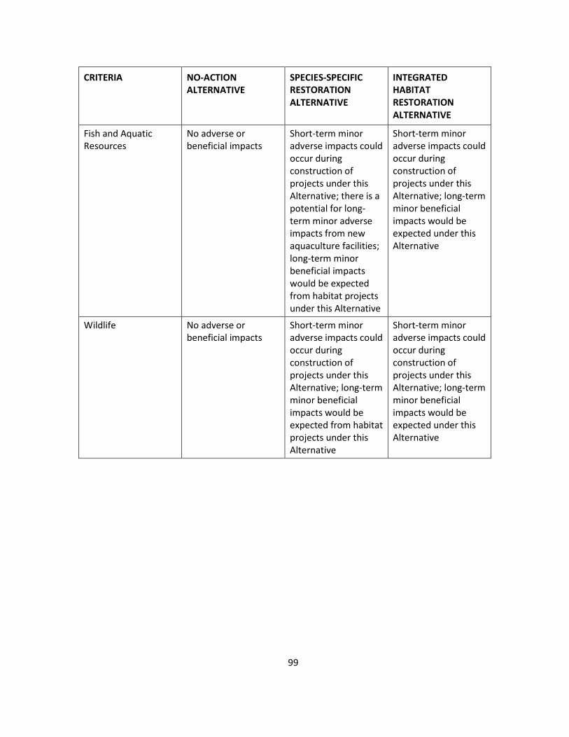
CRITERIA NO-ACTION ALTERNATIVE
SPECIES-SPECIFIC RESTORATION ALTERNATIVE
INTEGRATED HABITAT RESTORATION ALTERNATIVE
Fish and Aquatic Resources
No adverse or beneficial impacts
Short-term minor adverse impacts could occur during construction of projects under this Alternative; there is a potential for long-term minor adverse impacts from new aquaculture facilities; long-term minor beneficial impacts would be expected from habitat projects under this Alternative
Short-term minor adverse impacts could occur during construction of projects under this Alternative; long-term minor beneficial impacts would be expected under this Alternative
Wildlife No adverse or beneficial impacts
Short-term minor adverse impacts could occur during construction of projects under this Alternative; long-term minor beneficial impacts would be expected from habitat projects under this Alternative
Short-term minor adverse impacts could occur during construction of projects under this Alternative; long-term minor beneficial impacts would be expected under this Alternative
99

Blank Page
10. COORDINATION AND CONSULTATION
This section presents a review of the potentially applicable laws and regulations that govern the Trustees’ restoration projects. Many federal, state, tribal, and local laws and regulations need to be considered during the development of this project, as well as several regulatory requirements that are typically evaluated during the federal and state permitting process. A brief review of potentially applicable laws and regulations that may pertain to these projects is presented below. When implementing projects under this Alternative, the project managers will ensure that there is coordination among these programs where possible and that project implementation and monitoring is in compliance with all applicable laws and regulations.
Comprehensive Environmental Response, Compensation and Liability Act of 1980 (CERCLA), 42 USC §§ 9601 et seq., and National Oil and Hazardous Substances Pollution Contingency Plan, 40 CFR 300. CERCLA, also known as Superfund, provides the basic legal framework for clean-up and restoration of the nation’s hazardous substances sites. CERCLA establishes a hazard ranking system for assessing the nation’s contaminated sites, with the most contaminated sites being placed on the National Priorities List. Trustees are responsible, under CERCLA, for restoring injuries to natural resources and losses of natural resource services.
Oil Pollution Act of 1990 (OPA), 33 USC §§ 2701 et seq. OPA provides for the prevention of, liability for, removal of, and compensation for the discharge of the substantial threat of discharge of oil into or upon the navigable waters of the United States, adjoining shorelines, or the Exclusive Economic Zone. Section 1006(e) requires the President, acting through the Under Secretary of Commerce for Oceans and Atmosphere, to develop regulations establishing procedures for natural resource trustees in the assessment of damages for injury to, destruction of, loss of, or loss of use of natural resources covered by OPA. Section 1006(b) provides for the designation of federal, state, Indian tribal, and foreign natural resource trustees to determine resource injuries, assess natural resource damages (including the reasonable costs of assessing damages), present a claim, recover damages, and develop and implement a plan for the restoration, rehabilitation, replacement, or acquisition of the equivalent of the natural resources under their trusteeship.
Model Toxics Control Act, Ch. 70.105D RCW (1989) and Ch. 173-340 WAC (1992). Washington’s toxic clean-up law is the state equivalent of the federal Superfund program and is managed by the Washington Department of Ecology. The statewide regulations establish clean-up standards and requirements for managing contaminated sites. The Washington Department of Ecology is a participant in the NRDA restoration process as a member of the LDR Trustee Council, so compliance with the Model Toxics Control Act will be inherent in the Trustees’ decision-making process.
National Environmental Policy Act (NEPA), as amended, 42 U.S.C. §§ 4321 et seq.; 40 CFR Parts 1500-1508. NEPA was enacted in 1969 to establish a national policy for the protection of the environment. The Council on Environmental Quality was established to advise the president and to carry out certain other responsibilities relating to implementation of NEPA by federal agencies. Federal agencies are obligated to comply with the NEPA implementing regulations promulgated by the Council on Environmental Quality (40 CFR Parts 1500-1508). These
101

regulations outline the responsibilities of federal agencies under NEPA and provide specific procedures for preparing environmental documentation to comply with NEPA. This RP/PEIS was prepared to analyze and disclose whether the proposed action (implementing restoration under the PEIS) will have a significant effect on the quality of the human environment. All comments received will be considered before the lead federal agency makes a final recommendation. Subsequent NEPA analysis will be conducted for individual proposed projects; it is anticipated that Environmental Assessments (EAs) tiered to this RP/PEIS will typically be appropriate for these individual proposed projects; however, Environmental Impact Statements (EIS) may be prepared after the initiation of an EA if significant impacts are found. If an action alternative is selected (Alternative 2 or 3) after completion of the Final RP/PEIS, subsequent NEPA documents for individual projects would be developed and made available as drafts for public review and comment. All comments received on project-based analyses will be considered before the lead federal agency makes a decision and begins project implementation.
State Environmental Policy Act (SEPA), Chapter 43.21C RCW and Chapter 197-11 WAC. SEPA sets forth the state’s policy for protection and preservation of the natural environment. Local jurisdictions must also implement the policies and procedures of SEPA. Each project will undergo a public comment period under SEPA requirements and the SEPA checklist; the permit application, the permit, and the public comments will become a part of the administrative record for each project.
Clean Water Act (Federal Water Pollution Control Act), 33 USC §§ 1251 et seq. The Clean Water Act is the principal law governing pollution control and water quality of the nation’s waterways. It requires the establishment of guidelines and standards to control the direct or indirect discharge of pollutants to waters of the United States. Discharges of material into navigable waters are regulated under Sections 401 and 404 of the Clean Water Act. The U.S. Army Corps of Engineers has the primary responsibility for administering the Section 404 permit program. Under Section 401, projects that involve discharge or fill to wetlands or navigable waters must obtain certification of compliance with state water quality standards.
Rivers and Harbors Act, 33 USC §§ 401 et seq. This Act regulates development and use of the nation’s navigable waterways. Section 10 of the Act prohibits unauthorized obstruction or alteration of navigable waters and vests U.S. Army Corps of Engineers with authority to regulate discharges of fill and other materials into such waters. Actions that require Section 404 Clean Water Act permits are also likely to require permits under Section 10 of this Act.
Endangered Species Act of 1973 (ESA), 16 USC 1531 §§ et seq., 50 CFR Parts 17, 222, 224. The ESA directs all federal agencies to conserve endangered and threatened species and their habitats and encourages such agencies to utilize their authorities to further these purposes. Under the Act, NMFS and FWS publish lists of endangered and threatened species. Section 7 of the Act requires that federal agencies consult with these agencies to ensure their actions are not likely to jeopardize listed species or result in destruction or adverse modification of designated critical habitat. The regulatory permits and consultation conditions for projects implemented under this plan will set forth a number of operating measures designed to prevent or mitigate any such disturbances to these species.
102
Magnuson-Stevens Fishery Conservation and Management Act (MSA), 16 USC §§ 1801 et seq., 50 CFR Part 600. In 1996, the Act was reauthorized and changed by amendments to require that fisheries be managed at maximum sustainable levels and that new approaches are taken in habitat conservation. Essential Fish Habitat is defined broadly to include “those waters and substrate necessary to fish for spawning, breeding, feeding or growth to maturity” (62 Fed. Reg. 66551, § 600.10 Definitions). The Act requires consultation for all federal agency actions that may adversely affect Essential Fish Habitat. Under Section 305(b)(4) of the Act, NMFS is required to provide advisory conservation and enhancement recommendations to federal and state agencies for actions that adversely affect Essential Fish Habitat. Where federal agency actions are subject to ESA Section 7 consultations, such consultations may be combined to accommodate the substantive requirements of both ESA and MSA. NMFS will be consulted on each project regarding any MSA-managed species residing or migrating through the proposed project location.
Fish and Wildlife Coordination Act (FWCA), 16 USC §§ 661 et seq., and the Migratory Bird Treaty Act (MBTA) of 1918, 16 USC §§ 703 et seq. The FWCA requires that federal agencies consult with the FWS, NMFS, and state wildlife agencies for activities that affect, control, or modify waters of any stream or bodies of water, in order to minimize the adverse impacts of such actions on fish and wildlife resources and habitat. Similarly, the MBTA requires the protection of ecosystems of special importance to migratory birds against detrimental alteration, pollution, and other environmental degradation. These consultations are generally incorporated into Section 404 of the Clean Water Act, NEPA, or other federal permit, license, or review requirements.
Executive Order 11988: Floodplain Management. On May 24, 1977, President Carter issued Executive Order 11988, Floodplain Management. This Executive Order requires each federal agency to provide opportunity for early public review of any plans or proposals for actions in floodplains, in accordance with Section 2(b) of Executive Order 11514, as amended, including the development of procedures to accomplish this objective.
Executive Order 11990: Protection of Wetlands. On May 24, 1977, President Carter issued Executive Order 11990, Protection of Wetlands. This Executive Order requires each agency to provide opportunity for early public review of any plans or proposals for new construction in wetlands, in accordance with Section 2(b) of Executive Order 11514, as amended, including the development of procedures to accomplish this objective.
Executive Order 12898: Environmental Justice, as amended. On February 11, 1994, President Clinton issued Executive Order 12898, Federal Actions to Address Environmental Justice in Minority Populations and Low-Income Populations. This Executive Order requires each federal agency to identify and address, as appropriate, disproportionately high and adverse human health or environmental effects of its programs, policies, and activities on minority and low-income populations. EPA and the Council on Environmental Quality have emphasized the importance of incorporating environmental justice review in the analyses conducted by federal agencies under NEPA and of developing mitigation measures that avoid disproportionate environmental effects on minority and low-income populations.
103
The Trustees have not identified any disproportionate adverse impacts on human health or environmental effects on implementation of the Preferred Alternative on Native Americans or other minority or low-income populations, and believe that this project will be beneficial to these communities.
Executive Order 11514 (35 Fed. Reg. 4247) – Protection and Enhancement of Environmental Quality. This Executive Order directs federal agencies to monitor, evaluate, and control their activities in order to protect and enhance the quality of the nation’s environment; to inform and seek the views of the public about these activities; to share data gathered on existing or potential environmental problems or control methods; and to cooperate with other governmental agencies. The release of this Draft RP/PEIS and the types of projects envisioned under the Preferred Alternative are consistent with the goals of this Order. The proposed plan is the product of intergovernmental cooperation and will protect and enhance the environment. The restoration planning process has and continues to provide the public with information about the restoration efforts.
Executive Order 13007 – Indian Sacred Sites, and Executive Order 13175 – Consultation and Coordination with Indian Tribal Governments. Executive Order 13007 describes federal policy for accommodating sacred Indian sites. This Executive Order requires federal agencies with statutory or administrative responsibility for managing federal lands to: 1) accommodate access to and ceremonial use of Indian sacred sites by Indian religions practitioners; 2) avoid adversely affecting the physical integrity of such sacred sites; and 3) maintain the confidentiality of these sacred sites.
Executive Order 13175 exists to: 1) promote regular and meaningful consultation and collaboration with tribal officials in the development of federal policies that have tribal implications; 2) strengthen the United States government-to-government relationships with Indian tribes; and 3) reduce the imposition of unfounded mandates upon Indian tribes.
As part of the planning process for individual projects, appropriate coordination with federally recognized Indian tribes (Muckleshoot Indian Tribe and the Suquamish Indian Tribe) will be conducted.
Executive Order 12962 (60 Fed. Reg. 30,769) – Recreational Fisheries. This Executive Order directs federal agencies to, among other things, foster and promote restoration that benefits and supports viable, healthy, and sustainable recreational fisheries. The restoration projects that would be built under the Preferred Alternative would benefit recreational fish species and their prey.
Executive Order 13112 (64 Fed. Reg. 6,183) – Invasive Species. The purpose of Executive Order 13112 is to prevent the introduction of invasive species and provide for their control, and to minimize the economic, ecological, and human health impacts that invasive species cause.
No invasive species would be introduced by any projects under the Preferred Alternative, and any invasive species existing at the sites would be removed. Control of invasive species would also occur after restoration is implemented.
104
Information Quality Guidelines issued Pursuant to Public Law 106-554. Information disseminated by federal agencies to the public after October 1, 2002, is subject to information quality guidelines developed by each agency pursuant to Section 515 of Public Law 106-554 that are intended to ensure and maximize the quality of such information (i.e., the objectivity, utility, and integrity of such information). This PEIS is an information product covered by the information quality guidelines established by NOAA and the U.S. Department of the Interior for this purpose. The information collected herein complies with applicable guidelines.
Section 508 of the Rehabilitation Act, 29 U.S.C. 749D. Under Section 508 of the Rehabilitation Act, all federal agencies must take steps to afford persons with disabilities, including members of the public, access to information that is comparable to the access available to others. Section 508 was enacted in part to eliminate access barriers associated with information technology. For web accessibility under Section 508, documents posted must make text equivalents available for any non-text elements (including images, navigation arrows, multimedia objects (with audio or video), logos, photographs, or artwork) to enable users with disabilities access to all important (as opposed to purely decorative) content. Compliance also extends to making accessible other multimedia and outreach materials and platforms, acquisition of equipment and other assistive technologies, and computer software compliance. To provide for access to this document by disabled persons who use special assistive technology type devices and services, an electronic version of this draft RP/PEIS, incorporating electronically readable text equivalents for all non-text elements, has been created and is available at http://www.darrp.noaa.gov/northwest/lowerduwamishriver/restore.html. This website is regularly reviewed for Section 508 compliance. Disabled persons experiencing any difficulty accessing this document on this website should contact the DARRP Program webmaster at [email protected] for further technical assistance or to request an alternative means of access to the referenced information and data.
1855 Treaty of Point Elliott. The 1855 Treaty of Point Elliott sets forth articles of agreement between the United States and the Muckleshoot Indian Tribe, the Suquamish Tribe, and other federally recognized tribes within the Puget Sound area. Under the Supremacy clause of the United States Constitution, treaties are superior to any conflicting state laws or constitutional provisions.
Other potentially applicable federal, state, tribal, and local laws that are integrated into the regulatory process include:
• Archaeological Resources Protection Act, 16 USC §§ 469, et seq.
• Clean Air Act, as amended, 42 USC §§ 7401, et seq.
• Coastal Zone Management Act of 1982, as amended, 16 USC 1451 et seq.
• Marine Mammal Protection Act, 16 USC §§ 1361 et seq.
• National Historic Preservation Act, 16 USC §§ 470 et seq.
• Shoreline Management Act, Ch. 90.58 RCW and Ch. 173-14 WAC
• Historic Preservation Act, Ch. 27.34 RCW, Ch. 27.44 RCW, and Ch. 27.53 RCW
105

• Washington State Executive Order 05-05
• Washington State Hydraulic Code, Ch. 77.55 RCW and Ch. 220-110 WAC
106

11. REFERENCES
Anderson, Clifford and Osmek, Steve. 2005. RAPTOR STRIKE AVOIDANCE AT SEATTLE-TACOMA INTERNATIONAL AIRPORT: A BIOLOGICAL APPROACH. 2005 Bird Strike Committee-USA/Canada 7th Annual Meeting, Vancouver, BC. Paper. http://digitalcommons.unl.edu/birdstrike2005/1
Blomberg, G., C. Simenstad, and P. Hickey. 1988. Changes in Duwamish River Estuary Habitat Over the Past 15 years. In Proceedings of the First Annual Meeting on Puget Sound Research. Volume II, pp. 437–454. Seattle: Puget Sound Water Quality Authority.
Butler, V.L. 1990. Remains from the Black River Sites (45KI59 and 45KI51-D). Archaeology in Washington 2:49–65.
Campbell, S.K. (ed.) 1981. The Duwamish No. 1 Site: A Lower Puget Sound Shell Midden. Research Report No. 1. Seattle: Office of Public Archaeology, Institute for Environmental Studies, University of Washington.
Chatters, J.C. 1981a. Archaeology of the Sbabadid Site, 45KI51, King County, Washington. Seattle: Office of Public Archaeology, Institute for Environmental Studies, University of Washington.
Chatters, J.C. 1981b. Quadrant Site, Bothell. Test Excavation and Evaluation of Significance. Letter from James C. Chatters, Consulting Archaeologist, Ellensburg, Washington, to Ellen LaPorte, Shapiro and Associates Incorporated, November 24, 1981.
Chatters, J.C. 1988. Tualdad Altu ((45KI59): A 4th Century Village on the Black River King County Washington. Seattle: First City Equities.
Commencement Bay Natural Resource Trustees. 1997. Commencement Bay Natural Resource Damage Assessment Restoration Plan and Final Programmatic Environmental Impact Statement, by the National Oceanic and Atmospheric Administration and U.S. Fish and Wildlife Service. http://www.cbrestoration.noaa.gov/rp-eis/rpeis700.pdf
Cordell, J.R., L.M. Tear, K. Jensen, and H.A. Higgens. 1999. Duwamish River Coastal America Restoration and Reference Sites: Results from 1997 Monitoring Studies, FRI-UW-9903. Seattle: University of Washington.
Cordell, J., L. Tear, and K. Jensen. 2001. Biological Monitoring at Duwamish River Coastal America Restoration and Reference Sites: A Seven-Year Retrospective. SAFS-UW-0108, School of Aquatic and Fishery Sciences, Seattle, WA.
Dragovich, J.D., P.T. Pringle, and T.J. Walsh. 1994. Extent and Geometry of the Mid-Holocene Osceola Mudflow in the Puget Lowlands—Implications for Sedimentation and Paleogeography. Washington Geology 22(3):3–26.
107
Duwamish River Cleanup Coalition. 2009. Duwamish Valley Vision Map and Report. http://duwamishcleanup.org/wp-content/uploads/2012/02/Duwamish-Valley-Vision-Report-2009.pdf
Elliott Bay/Duwamish Restoration Program (EBDRP). 1994. Concept Document. Panel Publication 7. Seattle: King County Department of Metropolitan Services. http://www.darrp.noaa.gov/northwest/elliott/pdf/ebpnl07a.pdf
EBDRP. 1996. Concept Document. Addendum No.1. Panel Publication 14. Seattle: King County Water Pollution Control Division. http://www.darrp.noaa.gov/northwest/elliott/pdf/ebpnl14.pdf
EBDRP. 1997. Concept Document. Addendum No.2. Panel Publication 16. Seattle: NOAA Restoration Center Northwest. http://www.darrp.noaa.gov/northwest/elliott/pdf/ebpnl14.pdf (scroll to get to Addendum No. 2)
EBDRP. 2000. Intertidal habitat projects monitoring program. Panel Publication 23. Lacey, Washington: U.S. Fish and Wildlife Service, Western Washington Fish and Wildlife Office.
Elliott Bay Trustee Council (EBTC). 2009. Pre-Assessment Screen—Lower Duwamish River. Issued on December 2, 2009. http://www.darrp.noaa.gov/northwest/lowerduwamishriver/pdf/Final_Pre-Assessment_Screen_for_the_Lower_Duwamish_River._Elliot_Bay_Trustee_Council,_December_2,_2009..pdf
U.S. Environmental Protection Agency (EPA). 2005. Harbor Island Superfund Site: Second Five-Year Review Report, September, 2005. Seattle. http://yosemite.epa.gov/R10/CLEANUP.NSF/sites/HI/$FILE/2nd+5+Year+Review+9-27-05.pdf
EPA. 2007. Site Summary—Harbor Island, Washington, EPA Region 10, updated March 2007. http://yosemite.epa.gov/r10/nplpad.nsf/88d393e4946e3c478825631200672c95/173f0efa24b8a828852565920077c26c?OpenDocument
EPA. 2008. Remedial Investigation/Feasibility Study Work Plan for Lockheed West Seattle Superfund Site Final. Region 10. Seattle. http://yosemite.epa.gov/R10/CLEANUP.NSF/346a4822da38ae7088256da6005fc923/9458199e8119eba3882572910069d808/$FILE/Lockheed-RIFS-Workplan_TOC_Intro.pdf
EPA. 2010. Pacific Sound Resources—Site Description, updated May 2010. http://yosemite.epa.gov/r10/nplpad.nsf/0/daaf93829af354b885256594004de2e4!OpenDocument
Federal Register. 2010. Endangered and Threatened Wildlife and Plants: Threatened Status for Southern Distinct Population Segment of Eulachon. 75(52):13021–13024, March 18, 2010.
Fuerstenberg, R.R., K. Nelson, and R. Blomquist. 2003. Ecological Conditions and Limitations to Salmonid Diversity in the Green River, Washington, USA. In Seattle’s Urban Blueprint for Habitat Protection and Restoration. Seattle: King County Surface Water Management.
108

Green/Duwamish and Central Puget Sound Watershed Resource Inventory Area (WRIA 9). 2005. Salmon Habitat Plan: Making our Watershed Fit for a King. Seattle. http://www.govlink.org/watersheds/9/plan-implementation/HabitatPlan.aspx
Johnson, B.L., C.J. Henny, J.L. Kaiser, J.W. Davis, and E.P. Schulz. 2009. An Assessment of Contaminant Exposure and Effects to Ospreys Nesting along the Lower Duwamish River, Washington, 2006-2007. Administrative Report. Reston, VA: U.S. Geological Survey.
King County. 1999. King County Combined Sewer Overflow Water Quality Assessment for the Duwamish River and Elliott Bay. Prepared by Parametrix, Inc. and King County Department of Natural Resources. Seattle. http://www.kingcounty.gov/environment/watersheds/green-river/cso-wqa.aspx
King County. 2003a. Ancients of the Green, Salmon, Steelhead and Habitat. Seattle. http://www.govlink.org/watersheds/9/pdf/AncientsofGreen_back.pdf
King County. 2003b. Programmatic Biological Effects Analysis—King County River Management Program, by A. Johnson, K. Macdonald, and P. Trotter. Seattle.
King County. 2005a. Climate Impacts on Washington’s Hydropower, Water Supply, Forests, Fish, and Agriculture, by J.H. Casola, J.E. Kay, A.K. Snover, R.A. Norheim, and L.C. Whitely Binder. Seattle.
King County. 2005b. Historical Aquatic Habitats in the Green and Duwamish River Valleys and the Elliott Bay Nearshore, King County, Washington, by Brian Collins and Amir Sheikh. Seattle.
King County Department of Transportation. 2004. South Park Bridge Project Air Quality Technical Report. Prepared for the King County Department of Transportation by Parsons Brinckerhoff, Inc. Seattle.
Kruckeberg, A.R. 1991. The Natural History of Puget Sound Country. Seattle: University of Washington Press.
Lewarch, D.E. 2003a. Chapter 5: Late Pleistocene and Holocene Environments in Puget Sound. In D.E. Lewarch and L.L. Larson (eds)., Draft Historic Context Statement Hunter-Fisher-Gatherer-Resources King County Cultural Protection Project, pp. 5-1 – 5.62. LAAS Technical Report #2003-2. Gig Harbor, WA: Larson Anthropological Archaeological Services Limited.
Lewarch, D.E. 2003b. Chapter 7: The Archaeological Record of King County. In D.E. Lewarch and L.L. Larson (eds)., Draft Historic Context Statement Hunter-Fisher-Gatherer-Resources King County Cultural Protection Project, pp. 7-1 – 7.29. LAAS Technical Report #2003-2. Gig Harbor, WA: Larson Anthropological Archaeological Services Limited.
Lewarch, D.E. 2003c. Renton High School Indian Site (45KI501) Archaeological Data Recovery, King County, Washington. LAAS Technical Report #2004-11. Gig Harbor, WA: Larson Anthropological Archaeological Services Limited.
109

Lower Duwamish Waterway Group (LDWG). 2008. Lower Duwamish Waterway Sediment Transport analysis Report: Final. Submitted to U.S. Environmental Protection Agency and Washington State Department of Ecology.
LDWG. 2010a. Lower Duwamish Waterway Remedial Investigation Report. Seattle, July 2010.
LDWG. 2010b. Draft Final Feasibility Study, Lower Duwamish Waterway. Seattle, October 2012.
Mullineaux, D.R., 1970. Geology of the Renton, Auburn, and Black Diamond quadrangles, King County, Washington. Professional Paper 672. Reston, VA: U.S. Geological Survey.
Nelson, C.M. 1989. The Prehistory of the Puget Sound Region. In W. Suttles (ed.), Northwest Coast, Handbook of North American Indians, Vol. 7, pp. 481–484. Washington, DC: Smithsonian Institution.
National Oceanic and Atmospheric Administration (NOAA). 1985. Biology of Puget Sound Marine Mammals and Marine Birds: Population Health and Evidence of Pollution Effects, by J.S. Calambokidis, J. Speich, G.H. Peard, J.C. Steiger, D.M. Frye, and L.J. Lowenstine. NOAA Technical Memorandum. Rockville, Maryland.
NOAA. 1999. Discounting and the treatment of uncertainty in natural resource damage assessment. Technical Paper 99-1. NOAA Damage Assessment and Restoration Program.
NOAA. 2006. Habitat Equivalency Analysis: An Overview. March 21, 1995 (revised October 4, 2000, and May 23, 2006).
NOAA. 2007. Endangered and Threatened Species: Final Listing Determination for Puget Sound Steelhead. Federal Register, May 11, 2007).
NOAA. 2008. Recovery Plan for Southern Resident Killer Whales (Orcinus orca). National Marine Fisheries Service, Seattle, January 24, 2008.
NOAA. 2008. ESA Salmon Listing. National Marine Fisheries Service, Northwest Region, Seattle, October 22, 2008. http://www.nwr.noaa.gov/protected_species/salmon_steelhead/salmon_and_steelhead.html
Port of Seattle. 1979. Terminal 107 Environmental Studies: Wildlife Study, by D.J. Canning, S.G. Herman, and G.B. Shea. Seattle.
Port of Seattle. 2008. East Waterway Operable Unit Supplemental Remedial Investigation/Feasibility Study Existing Information Summary Report. Seattle, March 2008.
Port of Seattle. 2009a. The 2007 Economic Impact of the Port of Seattle. Seattle, February 10, 2009. http://www.portseattle.org/Supporting-Our-Community/Economic-Development/Documents/EconomicImpact_20091.pdf
110
Port of Seattle, 2009b. Lower Duwamish River Habitat Restoration Plan: An Inventory of Port of Seattle Properties, by AHBL, Seaport Planning Group, July 7, 2009. http://www.portseattle.org/Environmental/Water-Wetlands-Wildlife/Documents/Final_DuwamishMP_20090716.pdf
Puget Sound Clean Air Agency. 2011. 2009 Air Quality Data Summary, April 2011. http://www.pscleanair.org/news/library/reports/2009_AQDS_Report.pdf
Roach, B., and W. Wade. 2006. Policy Evaluation of Natural Resource Injuries using Habitat Equivalency Analysis. Ecological Economics 58:421–433.
Shared Strategy for Puget Sound. 2007. Puget Sound Salmon Recovery Plan—Coastal/Puget Sound Bull Trout. Seattle. http://www.psp.wa.gov/SR_map.php
Stoner, J.D. 1972. As cited in Lower Duwamish Waterway Group. Lower Duwamish Waterway Sediment Transport Analysis Report: Final. Submitted to U.S. Environmental Protection Agency and Washington State Department of Ecology, 2008.
University of Washington, Joint Institute for the Study of the Atmosphere and Oceans. 2005. Uncertain future: Climate change and its effects on Puget Sound. A report for the Puget Sound Action Team by the Climate Impacts Group, by A.K. Snover, P.W. Mote, L. Whitely Binder, A.F. Hamlet, and N.J. Mantua. Seattle.
University of Washington and Washington Department of Ecology. 2008. Sea Level Rise in the Coastal Waters of Washington State, by P. Mote, A. Peterson, S. Reeder, H. Shipman, and L.W. Binder. http://cses.washington.edu/db/pdf/moteetalslr579.pdf
U.S. Army Corps of Engineers. 1997. Green/Duwamish River Basin – General investigation ecosystem restoration study reconnaissance phase. January 17, 1997.
U.S. Army Corps of Engineers, Seattle District. 2000. Green/Duwamish River Basin Ecosystem Restoration Study, King County, Washington, Final Feasibility Report. Seattle.
U.S. Department of the Interior, Fish and Wildlife Service 1982. Regional Resource Plan. Region 1. Portland, Oregon.
U.S. Department of the Interior. Fish and Wildlife Service, 1986. Pacific Bald Eagle Recovery Plan. Portland, Oregon.
U.S. Department of the Interior, Fish and Wildlife Service, 1989. Catalog of Washington Seabird Colonies, by S. Speich and T. Wahl. Biological Report 88(6).
U.S. Department of the Interior, Fish and Wildlife Service 2000. Green/Duwamish River Basin Restoration Program, Fish and Wildlife Coordination Act Report. Lacey, Washington: Fish and Wildlife Coordination Service, Western Washington Office.
111
U.S. Department of the Interior, Fish and Wildlife Service, 2002. Preliminary Exposure Assessment of Dioxin-like Chlorobiphenyls in Great Blue Herons of the Lower Duwamish River in Seattle, Washington, by J. D. Krausmann. Lacey, Washington.
U.S. Department of the Interior, Fish and Wildlife Service, 2006. Elliott Bay/Duwamish Restoration Program: Intertidal Habitat Projects Monitoring Report, 2005. Lacey, Washington.
U.S. Department of the Interior. Fish and Wildlife Service, 2007. Preliminary Report for the Injury Assessment Study on Nesting Osprey from the Lower Duwamish River Seattle, Washington, by C.J. Henny, J.L. Kaiser, B.L. Johnson, E.P. Schulz, and J.W. Davis.
U.S. District Court, Western District of Washington at Seattle, Consent Decree, August 29, 1994. http://www.darrp.noaa.gov/northwest/elliott/pdf/psr.pdf
Warner, E.J., and R.L. Fritz. 1995. The Distribution and Growth of Green River Chinook Salmon (Oncorhynchus tshawytscha) and Chum Salmon (Oncorhynchus keta) Outmigrants in the Duwamish Estuary as a Function of Water Quality and Substrate. In Seattle’s Urban Blueprint for Habitat Protection and Restoration. King County Surface Water Management, 2003.
Washington State Department of Ecology and Department of Community, Trade, and Economic Development. 2006. Impacts of Climate Change on Washington’s Economy: A Preliminary Assessment of Risks and Opportunities. Publication No. 07-01-010, 2006. http://www.ecy.wa.gov/pubs/0701010.pdf
Washington Department of Fish and Wildlife. 2008. http://wdfw.wa.gov/index.html
WRIA 9. See Green/Duwamish and Central Puget Sound Water Resource Inventory Area (WRIA 9).
WRIA 9. 2006a. Fish Assemblages and Patterns of Chinook Salmon Abundance, Diet, and Growth at Restored Sites in the Duwamish River. J. Cordell, J. Toft, M. Cooksey, and A. Gray. Seattle.
WRIA 9. 2006b. Juvenile Chinook Duwamish River Studies. G. Ruggerone, T. S. Nelson, J. Hall, and E. Jeanes. Seattle.
Yates, S. 1988. Marine Mammals of Puget Sound, the San Juans and the Strait of Georgia. Old Saybrook, CT: The Globe Pequot Press.
Zarafonte, M., and S. Hampton. 2007. Exploring Welfare Implications of Resource Equivalency Analysis in Natural Resource Damage Assessments. Ecological Economics 61:134–145
Zehfuss, P.H., B.F. Atwater, J.W. Vallance, H. Brenniman, and T.A. Brown. 2003. Holocene Lahars and Their By-Products Along the Historical Path of the White River Between Mount Rainier and Seattle. In T.W. Swanson (ed.), Western Cordillera and Adjacent Areas, pp. 209–223. Boulder, CO: Geological Society of America.
112
12. GLOSSARY
Absolute value—in mathematics, the absolute value |a| of a real number is its numerical value without regard to its sign. So, for example, 3 is the absolute value of both 3 and −3.
Acute—having or experiencing a rapid onset and short but severe course; such as an acute disease.
Adaptive management—an explicitly experimental approach to managing natural resource projects by integrating design, management, and monitoring to systematically test assumptions in order to adapt and learn.
Anadromous—a species, such as salmon, that is born in freshwater, spends a large part of its life in the sea, and returns to freshwater rivers and streams to spawn.
Baseline—the condition that would exist but for the releases of hazardous substances.
Benthic—relating to the bottom of a sea or lake or to the organisms that live there
Bioaccumulation—the accumulation of a substance, such as a toxic chemical, in various tissues of a living organism or in the food web over time.
Bioassay—a procedure for determining the biological activity of a substance (e.g., a drug or pollutant) by measuring its effect on an organism, tissue, or cell, compared to a standard preparation.
Bird assemblages—a group of avian species that display similar behavioral traits and perform more or less the same ecological role, making similar use of the same resource.
Chinook salmon (ocean-type)—one of two types (races) of Chinook salmon that typically migrate to sea within the first three months of life, but may spend up to a year in freshwater prior to emigration to the sea. They also spend their ocean life in coastal waters. Ocean-type Chinook salmon return to their natal streams or rivers as spring, winter, fall, summer, and late-fall runs, but summer and fall runs predominate. Ocean-type Chinook salmon tend to use estuaries and coastal areas more extensively than other pacific salmonids for juvenile rearing.
Compensatory restoration—under CERCLA, restoration that compensates for interim loss of natural resources and services pending recovery.
Detritus—dead plant and animal matter, usually consumed by bacteria, but some remains.
Ecological niche—the ecological space or role occupied by a species in an ecosystem; activities and relationships a species has while obtaining the resources needed to survive; where it lives, how it interacts with other species, and how it obtains food.
113

Ecological services—the processes by which the environment produces resources that we often take for granted such as clean water, timber, habitat for fisheries, and the decomposition of wastes.
Ecological service loss—diminishment or degradation of ecosystem services (the benefits people, animals, and other organisms obtain from ecosystems) due to physical alteration or pollution.
Ecosystem-based—considers both the individual parts of a system (plants and animals and physical environment) and how the parts are functioning together as a whole system. An ecosystem-based approach relies on a variety of restoration strategies and takes into consideration the current and historical states of the ecosystem, including its structure and functions and the processes that maintain them.
Ecosystem processes—the physical, chemical, and biological actions or events that link organisms and their environment. Ecosystem processes include decomposition, production of plant matter, nutrient cycling, and fluxes of nutrients and energy.
Epibenthic—living on the surface of bottom sediments in a water body.
Estuary—partially enclosed coastal body of water, having an open connection with the ocean, where freshwater from inland is mixed with saltwater from the sea. An estuary is thus defined by salinity rather than geography
Estuarine—describes organisms that live in estuary areas.
Evolutionarily Significant Unit—a classification of populations that have substantial reproductive isolation which has led to adaptive differences so that the population represents a significant evolutionary component of the species; a combination of Distinct Population Segments that are collectively protected by the Endangered Species Act.
Herbivore—an animal that eats only plants.
Immune dysfunction—a reduction in the function of the immune system so that a body, organ, or organ system cannot perform normally.
Intertidal—occurring within, or forming, the area between the high and low tide levels in a coastal zone.
Invasive species—native or non-native species that heavily colonize a particular habitat, displacing desirable native species and adversely affecting the ecosystem.
Lesion—any visible, local abnormality of tissue (e.g., injury, wound, boil, sore, rash).
Lethal—causing death.
Limiting factor—controls a process, such as organism growth or species population size or distribution. The availability of food, predation pressure, or availability of shelter are examples
114

of factors that could be limiting for a species population in a specific area. For example, in the Lower Duwamish River, limiting factors for juvenile salmon include a lack of resting and feeding areas in the estuarine portion of the river as the juveniles acclimate from freshwater to saltwater.
Marsh—an area of soft, wet, low-lying land, characterized by grassy vegetation and often forming a transition zone between water and land.
Mean lower low water—the average height of the lower of the daily low waters over a 19-year period.
Natural resource services—the physical and biological functions provided by the resource that serve the ecological and human uses of the environment. Examples of ecological services include plant and animal habitat, food supply, etc.
Nekton—Animals that swim or move freely in the ocean.
Nexus—the degree of the linkage between the injured natural resource and the restoration actions. The strength of a nexus is determined, in part, by the location of the restoration in comparison to the location of the injured resources.
Osmoregulation—the control of the concentration of body fluids, a vital function affecting all aspects of fish health. If a fish is unable to regulate the effects of osmosis it will die. Salmon must maintain a constant volume of body fluids while migrating from freshwater to saltwater and back again. The behavioral (drinking or not drinking) and physiological changes a salmon must make when moving from freshwater to saltwater—and vice versa—are essential, but cannot be accomplished immediately. Salmon do this by spending days to weeks in estuarine waters, gradually moving into areas with increased salinity.
Oxbow—a U-shaped bend in a river or stream.
PAHs (polycyclic aromatic hydrocarbons)—a group of chemicals naturally found in coal, coal tars, oil, wood, tobacco, and other organic materials. There are more than 100 different PAHs. PAHs are the waxy solids found in asphalt, crude oil, coal, coal tar pitch, creosote, and roofing tar. Some types of PAHs are used in medicines and to make dyes, plastics, and pesticides. PAHs can be divided into the following two groups based on their physical, chemical, and biological characteristics:
• PAHs, Low Molecular Weight—PAHs with 2 to 3 rings, such as naphthalenes, fluorenes,phenanthrenes, and anthracenes, that have significant acute toxicity to aquatic organisms.In general, low molecular weight PAHs are more soluble and volatile and have less affinityfor surfaces than do high molecular weight PAHs.
• PAHs, High Molecular Weight—PAHs with more than 3 rings (such as crysene). Severalmembers of the high molecular weight PAHs are carcinogenic. In general, high molecularweight PAHs are less soluble and volatile than low molecular weight PAHs.
115
PCBs (polychlorinated biphenyls)—any of a family of industrial compounds produced by chlorination of biphenyl, noted primarily as an environmental pollutant that accumulates in animal tissue with resultant pathogenic and teratogenic effects.
Primary restoration—under CERCLA, actions taken to directly restore natural resources and services to baseline under an accelerated time frame.
Primary productivity—production by green plants.
Process water—water used in a manufacturing or treatment process or in the actual product manufactured. Examples would include water used for washing, rinsing, direct contact, cooling, solution make-up, chemical reactions, and gas scrubbing in industrial and food processing applications.
Rearing habitat—an area where larval and juvenile fish find food and shelter.
Riparian habitat—areas adjacent to rivers and streams with a differing density, diversity, and productivity of plant and animal species relative to nearby uplands.
Salt marsh/fringing salt marsh—a coastal wetland that extends landward up to the highest high tide line and is characterized by plants that are well adapted to living in saline soils. Fringing marshes are small salt marshes that form along estuary channels, protected coves, and other areas shielded from heavy wave action.
Secondary productivity—the biomass produced by heterotrophic organisms (who cannot synthesize their own food, and eat plants or other animals).
Service loss—see Ecological service loss.
Sublethal—referring to that which does not kill a cell or organism, but usually forces adaptation for survival.
Subtidal—areas below the low tide that are continuously submerged.
Tiering—a staged approach to NEPA described in the Council on Environmental Quality’s Regulations for Implementing the Procedural Provisions of the National Environmental Policy Act (40 CFR 1500 – 1508). Tiering addresses broad systems level programs and issues in initial (Tier 1) analyses, and analyzes site-specific proposals and impacts in subsequent tier studies. In ourcase, the Restoration Plan and Programmatic Environmental Impact Statement would be the broad Tier 1 level, and the project-level Environmental Assessments would be done subsequently as specific restoration projects are proposed.
Total organic carbon (TOC)—a measure of the amount of carbon in a sample originating from organic matter only.; a physical sediment factor that can influence the concentration of other compounds.
116

Toxicopathic lesion—abnormal tissue caused by the action of a poison.
Transition zone—area where freshwater and saltwater mix, resulting in brackish conditions.
117

Blank Page

13. LIST OF PREPARERS
Rebecca Hoff, NOAA
Laurel Jennings, NOAA
John Kern, NOAA
Laurie Lee, NOAA
Marla Steinhoff, NOAA
Jeff Krausmann, U.S. Fish and Wildlife Service
Glen St. Amant, Muckleshoot Indian Tribe
Rich Brooks, Suquamish Tribe
Donna Podger, Washington Department of Ecology
Craig Thompson, Washington Department of Ecology
Randy Carman, Washington Department of Fish and Wildlife
Shayne Cothern, Washington Department of Natural Resources
119

14. INDEX
baseline .......................................................................... 18, 20, 21, 27, 32, 33, 34, 80, 96, 113, 116
birds ......... 12, 22, 28, 30, 31, 32, 33, 41, 46, 47, 55, 57, 58, 59, 62, 64, 67, 68, 69, 72, 83, 103, 111
Chinook salmon .............................. 22, 31, 32, 47, 48, 58, 59, 60, 66, 67, 68, 89, 93, 109, 112, 113
flatfish ......................................................................................................... 22, 30, 32, 55, 57, 59, 67
Habitat Equivalency Analysis ................................................................................................. 27, 111
HEA ................................................................................................................... 27, 28, 29, 30, 38, 40
Integrated Habitat Restoration Alternative ............. 2, 81, 83, 85, 86, 87, 88, 89, 90, 91, 92, 93, 94
marsh .... 4, 31, 32, 44, 45, 46, 50, 55, 57, 58, 59, 62, 65, 67, 68, 69, 70, 72, 73, 74, 83, 86, 92, 115, 116
mudflat ........................................ 4, 22, 24, 31, 45, 46, 55, 58, 59, 65, 67, 68, 69, 70, 72, 81, 83, 92
Natural resource services ......................................................................................... 15, 27, 101, 115
primary restoration .................................................................................................... 18, 20, 21, 116
riparian buffer ................................................................................................................ 4, 57, 59, 67
riparian habitat ............................................................................................... 57, 67, 69, 70, 92, 116
species-specific ........................................................... 2, 3, 79, 81, 82, 85, 87, 88, 90, 91, 93, 94, 96
threatened species ............................................................................................. 47, 48, 93, 102, 111
trust resources .................................................................................................. 18, 19, 21, 30, 55, 62
wetlands ......................................................................... 20, 22, 23, 24, 45, 49, 55, 67, 88, 102, 103
120

15. DISTRIBUTION LIST
In addition to the individuals and organizations listed below, the document is also available for download at http://www.darrp.noaa.gov/northwest/lowerduwamishriver/restore.html
Contact Name Organization
Government Agencies
Christine Reichgott U.S. Environmental Protection Agency Alison Hiltner U.S. Environmental Protection Agency Shawn Blocker U.S. Environmental Protection Agency Renee Dagseth U.S. Environmental Protection Agency
Piper Petersen-Lee U.S. Environmental Protection Agency Ravi Sanga U.S. Environmental Protection Agency
Jeff Krausmann U.S. Department of Interior, Fish and Wildlife Service
Kymberly Takasaki U.S. Army Corps of Engineers
Glen St Amant Muckleshoot Tribe
Rich Brooks Suquamish Tribe
Donna Podger Washington Department of Ecology
Randy Carman Washington Department of Fish and Wildlife
Shane Cothern Washington Department of Natural Resources
Sue Meyer King County Doug Osterman King County (WRIA9)
Kathy Bahnick Port of Seattle
George Blomberg Port of Seattle Jon Sloan Port of Seattle
Judi Gladstone City of Seattle
Carol Lumb City of Tukwila
Non-Governmental Organizations
BJ Cummings Duwamish River Cleanup Coalition Kevin Burrell ECOSS Cari Simson Green Duwamish Watershed Alliance
121

Contact Name Organization Heather Trim People for Puget Sound Steve Richmond Puget Creek Watershed Alliance
Other Entities
AECOM Technology Corporation Anchor Environmental Ash Grove Cement
Bluefield Holdings Inc. BP West Coast Products LLC Boeing
Boyer Towing BPB Gypsum Cascadia Law
Chemithon Corporation Collaborative Focus Container Properties LLC
Crowley Marine Delta Marine Douglas Management
Duwamish Shipyard EMJ ESI Management
Exxon Mobile Farallon Consulting Fox Ave Building LLC
General Services Administration Geomatrix
Graham Dunn Halvorsen, Mary Catherine Houlihan Law
Hurlen Construction James Gilmur Johannessen & Associates
Jorgenson Forge
122
Kinder Morgan Lafarge Corporation
Lehigh Northwest Cement Lockheed Shipbuilding Lone Star Northwest Inc
Longview Fibre Company Lynden Inc. Manson Construction Company
Merrill Creek Holdings LLC PACCAR Stoel Reeves
Trotsky, Herman & Jacqualine URS Corporation
Vigor Marine
123

U.S. Department of Commerce · National Oceanic and Atmospheric Administration