Embed Size (px)
Citation preview
Page 1 of 13
Deepwater Horizon NRDA Monitoring Plan
Phase I Early Restoration:
Lake Hermitage Marsh Creation – NRDA Early Restoration Project
Prepared by: Louisiana Natural Resource Trustees
March 2015
Table of Contents 1.0 Introduction ...................................................................................................................................... 2
1.1 Project Overview ................................................................................................................................ 2
1.2 Restoration Objectives and Performance Criteria ............................................................................. 2
2.0 Performance Monitoring .................................................................................................................. 6
3.0 Monitoring Schedule ......................................................................................................................... 9
3.1 Additional Monitoring Efforts in the Vicinity of the Project ......................................................... 9
4.0 Reporting and Data Requirements ................................................................................................. 10
4.1 Field Data Documentation ............................................................................................................... 10
4.2 Field Data Transcription, Validation, and Analysis ........................................................................... 12
4.3 Document and Sample Retention Requirements ............................................................................ 12
4.4 Data and Document Transfers ......................................................................................................... 13
4.5 Reporting Schedule .......................................................................................................................... 13
5.0 References ...................................................................................................................................... 13
Page 2 of 13
1.0 Introduction
The Louisiana Natural Resource Trustees (Trustees) developed this monitoring plan (Plan) for the Lake Hermitage Marsh Creation – Natural Resource Damage Assessment (NRDA) Early Restoration Project (Project). This Project is included as a Phase I Deepwater Horizon early restoration project and is intended to compensate the public for injury to brackish marsh habitat in the Barataria Hydrologic Basin (Deepwater Horizon Natural Resource Trustees, 2012). The purpose of this plan is to describe monitoring activities that will be conducted to evaluate and document restoration effectiveness, including performance criteria for determining the success of restoration or need for interim corrective action (15 CFR 990.55(b)(1)(vii)). This Plan will be implemented by the Coastal Restoration and Protection Authority of Louisiana (CPRA) in coordination with the Louisiana co-trustees and may be modified over time based on the management needs for the Project.
1.1 Project Overview
The Project involves the creation of marsh within a project footprint known as the “Lake Hermitage Marsh Creation (BA-0042) Project” developed for and funded through the Coastal Wetlands Planning, Protection and Restoration Act (CWPPRA) Program. This Project substitutes approximately 104 acres of created brackish marsh habitat for approximately 5-6 acres of earthen terraces that would otherwise have been constructed within the CWPPRA project boundary.
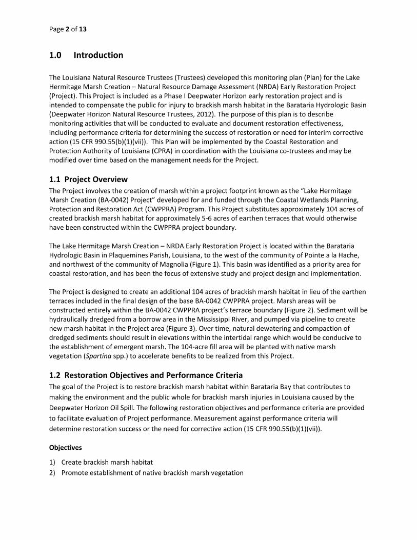
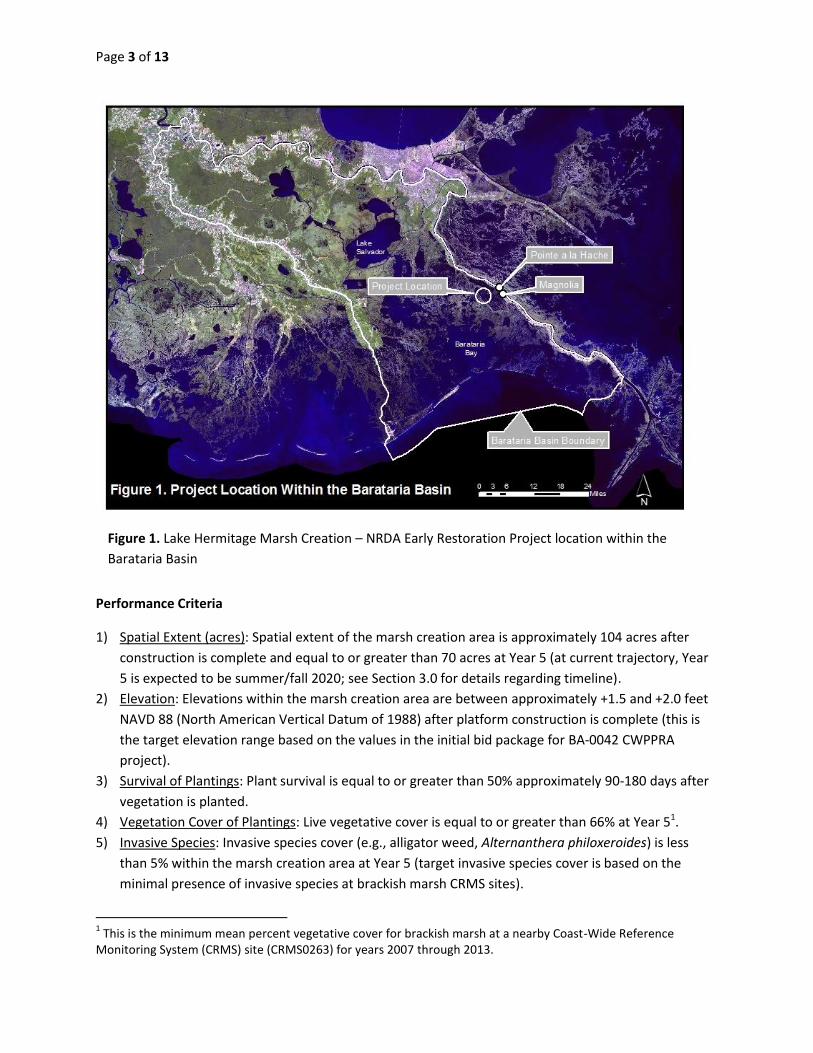
The Lake Hermitage Marsh Creation – NRDA Early Restoration Project is located within the Barataria Hydrologic Basin in Plaquemines Parish, Louisiana, to the west of the community of Pointe a la Hache, and northwest of the community of Magnolia (Figure 1). This basin was identified as a priority area for coastal restoration, and has been the focus of extensive study and project design and implementation. The Project is designed to create an additional 104 acres of brackish marsh habitat in lieu of the earthen terraces included in the final design of the base BA-0042 CWPPRA project. Marsh areas will be constructed entirely within the BA-0042 CWPPRA project’s terrace boundary (Figure 2). Sediment will be hydraulically dredged from a borrow area in the Mississippi River, and pumped via pipeline to create new marsh habitat in the Project area (Figure 3). Over time, natural dewatering and compaction of dredged sediments should result in elevations within the intertidal range which would be conducive to the establishment of emergent marsh. The 104-acre fill area will be planted with native marsh vegetation (Spartina spp.) to accelerate benefits to be realized from this Project.
1.2 Restoration Objectives and Performance Criteria
The goal of the Project is to restore brackish marsh habitat within Barataria Bay that contributes to
making the environment and the public whole for brackish marsh injuries in Louisiana caused by the
Deepwater Horizon Oil Spill. The following restoration objectives and performance criteria are provided
to facilitate evaluation of Project performance. Measurement against performance criteria will
determine restoration success or the need for corrective action (15 CFR 990.55(b)(1)(vii)).
Objectives
1) Create brackish marsh habitat
2) Promote establishment of native brackish marsh vegetation
Page 3 of 13
Figure 1. Lake Hermitage Marsh Creation – NRDA Early Restoration Project location within the
Barataria Basin
Performance Criteria
1) Spatial Extent (acres): Spatial extent of the marsh creation area is approximately 104 acres after
construction is complete and equal to or greater than 70 acres at Year 5 (at current trajectory, Year
5 is expected to be summer/fall 2020; see Section 3.0 for details regarding timeline).
2) Elevation: Elevations within the marsh creation area are between approximately +1.5 and +2.0 feet
NAVD 88 (North American Vertical Datum of 1988) after platform construction is complete (this is
the target elevation range based on the values in the initial bid package for BA-0042 CWPPRA
project).
3) Survival of Plantings: Plant survival is equal to or greater than 50% approximately 90-180 days after
vegetation is planted.
4) Vegetation Cover of Plantings: Live vegetative cover is equal to or greater than 66% at Year 51.
5) Invasive Species: Invasive species cover (e.g., alligator weed, Alternanthera philoxeroides) is less
than 5% within the marsh creation area at Year 5 (target invasive species cover is based on the
minimal presence of invasive species at brackish marsh CRMS sites).
1 This is the minimum mean percent vegetative cover for brackish marsh at a nearby Coast-Wide Reference
Monitoring System (CRMS) site (CRMS0263) for years 2007 through 2013.

Page 4 of 13
Figure 2. Lake Hermitage Marsh Creation CWPPRA project (BA-0042) design before the NRDA Project
was substituted for the terrace field (terrace field shown in orange south of Marsh Creation Area B)
Page 5 of 13
Figure 3. Lake Hermitage Marsh Creation showing NRDA Project component that replaces terrace field.
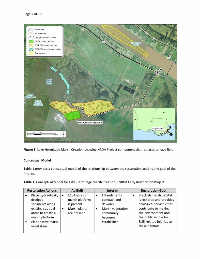
Conceptual Model
Table 1 provides a conceptual model of the relationship between the restoration actions and goal of the
Project.
Table 1. Conceptual Model for Lake Hermitage Marsh Creation – NRDA Early Restoration Project
Restoration Actions As-Built Interim Restoration Goal
Place hydraulically dredged sediments along existing subtidal areas to create a marsh platform
Plant native marsh vegetation
≥104 acres of marsh platform is present
Marsh plants are present
Fill sediments compact and dewater
Marsh vegetation community becomes established
Brackish marsh habitat is restored and provides ecological services that contribute to making the environment and the public whole for Spill-related injuries to these habitats
Page 6 of 13
2.0 Performance Monitoring
Successful implementation of the Project will be measured by assessing the performance of the restored
brackish marsh habitat. Performance will be evaluated using both qualitative and quantitative measures
related to the Project goals and objectives. Performance monitoring is organized by restoration
objective, with each objective having one or more monitoring parameters. Each parameter provides
information on the monitoring methods, timing and frequency, sample size, sampling sites, performance
criteria, and potential corrective actions.
The CPRA currently maintains a monitoring program that provides ecological data and research to
support the planning, design, construction, evaluation, and adaptive management of Louisiana’s
wetland restoration projects (Folse et al. 2012). This Coast-wide Reference Monitoring System –
Wetlands (CRMS) was developed and implemented to improve the monitoring program’s effectiveness
in evaluating individual restoration projects, as well as the combined effects of multiple projects, by
providing a network of reference sites where data are collected on a regular basis (Steyer et al. 2003).
To the extent possible, the monitoring methodologies used for the Project will be consistent with the
methodologies described in Folse et al. (2012).
Objective #1: Create brackish marsh habitat
Parameter 1: Spatial Extent (acres) of marsh creation area
Methods:
1. Collect topographic survey data using RTK GPS (Real Time Kinematic Global
Positioning System) methodology and/or another equivalent method;
2. Acquire high-resolution, near-vertical, orthorectified aerial imagery;
3. Collect spatial measurements using hand-held GPS (optional);
4. Quantify spatial extent of the marsh area using the collected information and best
available science and methods.
Timing and Frequency:
Method 1: As-built topographic survey (once). Topographic surveys will be acquired
shortly after fill placement is completed and serve as a data set for determining
spatial extent of the created marsh area.
Method 2: Aerial imagery (at least twice). Aerial imagery will be acquired after fill
placement is completed and once again in Year 5. The data will assist in the
quantification of spatial extent of the created marsh area.
Method 3: GPS Surveys (optional). Continuous spatial measurements may be
collected along the perimeter of the created marsh area to assist in the delineation
and quantification of spatial extent, if needed. This method is optional.
Sample Size:
Method 1: As-built topographic survey. Construction contractor will survey marsh
creation areas during and after construction and perform operational corrections to
achieve the required spatial extent (acres).
Page 7 of 13
Method 2: Aerial imagery. The spatial resolution of imagery will likely not exceed 1
meter pixel size.
Method 3: GPS Surveys (optional): Continuous spatial measurement
Site: Lake Hermitage NRDA Restoration site
Performance Criterion:
Spatial extent of the marsh creation area is approximately 104 acres after
construction is complete and equal to or greater than 70 acres at Year 5.
Potential Corrective Actions: Plant vegetation
Parameter 2: Elevation of marsh creation area
Method: Collect topographic survey data using RTK GPS methodology and/or another
equivalent method.
Timing and Frequency:
As-built topographic survey (once). Topographic surveys will be acquired shortly
after fill placement is completed and serve as a data set for determining elevation of
the created marsh area.
Sample Size: Construction contractor will survey elevations across the created marsh area and
perform operational corrections to achieve the target elevation range of 1.5 to 2.0
feet NAVD 88.
Site: Lake Hermitage NRDA Restoration site
Performance Criterion:
Elevations within the marsh creation area are between approximately +1.5 and +2.0
feet NAVD 88 (North American Vertical Datum of 1988) after platform construction
is complete.
Potential Corrective Actions:
Adding sediment and/or re-grading
Objective #2: Promote establishment of native brackish marsh vegetation
Parameter 1: Survival of Plantings (% survival)
Method: Count live and dead plants within the planted areas to determine if the planted
vegetation is surviving. In the event that natural colonization of vegetation occurs in
the vicinity of the plantings making it difficult to distinguish between planted
vegetation and natural recruitment, a survival measurement will not be collected at
that sampling location.
Timing and Frequency:
As-built plant survival survey (once). Survival of plantings will be measured
approximately 90 – 180 days after vegetation is planted.
Sample Size: Sampling plots in planted areas.
Site: Lake Hermitage NRDA Restoration site
Page 8 of 13
Performance Criterion:
Survival of vegetative plantings is equal or greater than 50% approximately 90 - 180
days after vegetation is planted.
Potential Corrective Actions: Replant vegetation.
Parameter 2: Vegetative Cover
Method: Five transects will be established within the Project site, with 10 vegetation stations
randomly located along each transect, for a total of 50 vegetation stations. Plots will
be established at each station and marked with corner poles to allow for revisiting
over time. Vegetation species composition, percent live cover, and height will be
determined using methods described in Folse et al. (2012), within the 50 vegetation
stations described above.
Timing and Frequency:
As-built vegetative cover survey (once). Vegetation cover will be measured
approximately 90 – 180 days after vegetation is planted (currently anticipated for
spring 2015).
Post Construction vegetative cover survey (twice). Vegetation cover will be
measured during the fall of Years 3 and 5.
Sample Size: Fifty randomly selected vegetation stations will be established across the Project
site and sampling will be conducted at each station.
Site: Lake Hermitage NRDA Restoration site
Performance Criterion: Live vegetative cover of native brackish marsh species (Lester et al., 2005)
is equal to or greater than 66% within the marsh creation area at Year 5.
Potential Corrective Actions:
Plant additional vegetation, add fertilizer, and/or continue to monitor.
Parameter 3: Invasive Species Cover
Method: Five transects will be established within the Project site, with 10 vegetation stations
randomly located along each transect, for a total of 50 vegetation stations. Plots will
be established at each station and marked with corner poles to allow for revisiting
over time.
Timing and Frequency:
Post Construction vegetative cover survey (twice). Invasive species cover will be
measured approximately 3 years and 5 years following the as-built vegetation cover
survey.
Sample Size: Fifty vegetation stations will be established across the Project site and samples will
be taken at each station.
Site: Lake Hermitage NRDA Restoration site
Performance Criterion:
Invasive species (e.g., alligator weed, Alternanthera philoxeroides) cover will be less
than 5% within the marsh creation area at Year 5.
Potential Corrective Actions: Removal of invasive species, and/or continue to monitor
Page 9 of 13
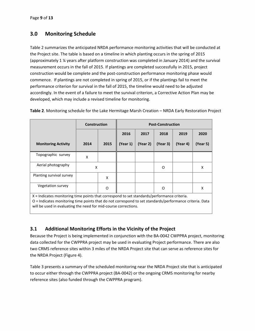
3.0 Monitoring Schedule
Table 2 summarizes the anticipated NRDA performance monitoring activities that will be conducted at
the Project site. The table is based on a timeline in which planting occurs in the spring of 2015
(approximately 1 ¼ years after platform construction was completed in January 2014) and the survival
measurement occurs in the fall of 2015. If plantings are completed successfully in 2015, project
construction would be complete and the post-construction performance monitoring phase would
commence. If plantings are not completed in spring of 2015, or if the plantings fail to meet the
performance criterion for survival in the fall of 2015, the timeline would need to be adjusted
accordingly. In the event of a failure to meet the survival criterion, a Corrective Action Plan may be
developed, which may include a revised timeline for monitoring.
Table 2. Monitoring schedule for the Lake Hermitage Marsh Creation – NRDA Early Restoration Project
Monitoring Activity
Construction Post-Construction
2014 2015
2016
(Year 1)
2017
(Year 2)
2018
(Year 3)
2019
(Year 4)
2020
(Year 5)
Topographic survey X
Aerial photography X
O
X
Planting survival survey X
Vegetation survey O
O
X
X = Indicates monitoring time points that correspond to set standards/performance criteria. O = Indicates monitoring time points that do not correspond to set standards/performance criteria. Data will be used in evaluating the need for mid-course corrections.
3.1 Additional Monitoring Efforts in the Vicinity of the Project
Because the Project is being implemented in conjunction with the BA-0042 CWPPRA project, monitoring
data collected for the CWPPRA project may be used in evaluating Project performance. There are also
two CRMS reference sites within 3 miles of the NRDA Project site that can serve as reference sites for
the NRDA Project (Figure 4).
Table 3 presents a summary of the scheduled monitoring near the NRDA Project site that is anticipated
to occur either through the CWPPRA project (BA-0042) or the ongoing CRMS monitoring for nearby
reference sites (also funded through the CWPPRA program).
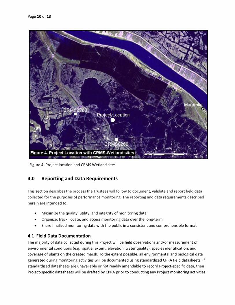
Page 10 of 13
Figure 4. Project location and CRMS Wetland sites
4.0 Reporting and Data Requirements
This section describes the process the Trustees will follow to document, validate and report field data
collected for the purposes of performance monitoring. The reporting and data requirements described
herein are intended to:
Maximize the quality, utility, and integrity of monitoring data
Organize, track, locate, and access monitoring data over the long-term
Share finalized monitoring data with the public in a consistent and comprehensible format
4.1 Field Data Documentation
The majority of data collected during this Project will be field observations and/or measurement of
environmental conditions (e.g., spatial extent, elevation, water quality), species identification, and
coverage of plants on the created marsh. To the extent possible, all environmental and biological data
generated during monitoring activities will be documented using standardized CPRA field datasheets. If
standardized datasheets are unavailable or not readily amendable to record Project-specific data, then
Project-specific datasheets will be drafted by CPRA prior to conducting any Project monitoring activities.
Page 11 of 13
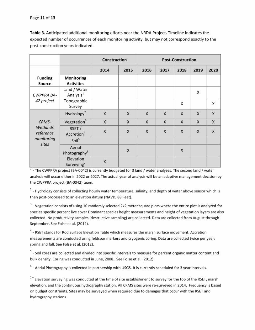
Table 3. Anticipated additional monitoring efforts near the NRDA Project. Timeline indicates the
expected number of occurrences of each monitoring activity, but may not correspond exactly to the
post-construction years indicated.
Construction Post-Construction
2014 2015 2016 2017 2018 2019 2020
Funding Source
Monitoring Activities
CWPPRA BA-42 project
Land / Water Analysis1
X
Topographic Survey
X
X
CRMS-Wetlands reference
monitoring sites
Hydrology2 X X X X X X X
Vegetation3 X X X X X X X
RSET / Accretion4
X X X X X X X
Soil5
Aerial Photography6
X
X
Elevation Surveying7
X
1 - The CWPPRA project (BA-0042) is currently budgeted for 3 land / water analyses. The second land / water
analysis will occur either in 2022 or 2027. The actual year of analysis will be an adaptive management decision by
the CWPPRA project (BA-0042) team.
2 - Hydrology consists of collecting hourly water temperature, salinity, and depth of water above sensor which is
then post-processed to an elevation datum (NAVD, 88 Feet).
3 - Vegetation consists of using 10 randomly selected 2x2 meter square plots where the entire plot is analyzed for
species specific percent live cover Dominant species height measurements and height of vegetation layers are also
collected. No productivity samples (destructive sampling) are collected. Data are collected from August through
September. See Folse et al. (2012).
4 - RSET stands for Rod Surface Elevation Table which measures the marsh surface movement. Accretion
measurements are conducted using feldspar markers and cryogenic coring. Data are collected twice per year:
spring and fall. See Folse et al. (2012).
5 - Soil cores are collected and divided into specific intervals to measure for percent organic matter content and
bulk density. Coring was conducted in June, 2008.. See Folse et al. (2012).
6 - Aerial Photography is collected in partnership with USGS. It is currently scheduled for 3 year intervals.
7 – Elevation surveying was conducted at the time of site establishment to survey for the top of the RSET, marsh
elevation, and the continuous hydrography station. All CRMS sites were re-surveyed in 2014. Frequency is based
on budget constraints. Sites may be surveyed when required due to damages that occur with the RSET and
hydrography stations.
Page 12 of 13
The Project-specific datasheets will be submitted to the Trustees by CPRA for review prior to use. The
Trustees must submit their approval or disapproval of the datasheets within five (5) calendar days of
receipt.
CPRA will lead collection of field data, in collaboration with the co-trustees. All tangible forms of field
data will be reviewed by CPRA for completeness and accuracy before being finalized. Original hardcopy
datasheets and notebooks and any photo microSD cards will be retained by CPRA in a secure location in
accordance with agency and litigation-hold requirements.
4.2 Field Data Transcription, Validation, and Analysis
All field datasheets and notebook entries will be scanned to PDF files and will be archived along with the
hardcopy datasheets. Electronic data files should be named with the date on which the file was created.
Where possible, a ReadMe file should be included that describes when the file was created and by
whom, and any explanatory notes on the file contents. If a data file is revised, a new copy should be
made and the original preserved.
Relevant Project data that are handwritten on hardcopy datasheets or notebooks will be transcribed
(entered) into Excel spreadsheets (or similar digital format) for required data analysis. After
transcription of the data, a second person not associated with data transcription will perform a 100%
check of the data in the electronic data sheets against the original hardcopy datasheets and/or
notebooks, and will make any corrections to transcription errors as appropriate before data are used for
any analyses or distributed outside of the agency. After any and all identified errors are addressed, data
are considered to be QA/QC’d. When the data transcription process is complete, electronic datasets can
be used for data analysis. Analyses will be conducted by the Trustees to determine if the Project has met
the performance criteria.
4.3 Document and Sample Retention Requirements
Hardcopy and electronic documents generated during data collection will be retained by CPRA and the
Louisiana Oil Spill Coordinator’s Office (LOSCO). Preservation includes retaining and not altering any
such thing as to its form, content, or manner of filing.
The NRDA monitoring plan for this Project does not include removing any physical samples from the
marsh sample sites. However, if any samples are taken, as stipulated in the June 24, 2011 U.S. District
Court, Eastern District of Louisiana Pretrial Order No. 37 Relating to the United States’ and Natural
Resource Trustees’ Testing of Samples, these samples collected from the field and subsequently
analyzed for this Project will be retained. Project sample retention policies will apply to all samples
collected and removed from the marsh sampling sites during Project monitoring activities. This primarily
includes above or below-ground biomass or sediment samples that are removed from sampling sites to
be analyzed after the sampling event concludes. At a minimum, samples will be labeled with the sample
site name, replicate number, and date collected.
Page 13 of 13
4.4 Data and Document Transfers
Data and document transfers between the Trustees will be conducted throughout the course of this
Project. Transfer of electronic files will be accomplished via email and secure FTP.
4.5 Reporting Schedule
The Trustees will produce a Final Construction Report at the end of construction and a monitoring
progress report after the Year 3 sampling event (see Table 2 in Section 3.0). A comprehensive
monitoring report will be produced after the Year 5 sampling is completed. If corrective actions are
necessary, the Trustees will develop a Corrective Action Plan and provide a schedule of performance
monitoring and reporting. All reports will contain monitoring data that have been validated and have
undergone final quality control checks.
5.0 References
Deepwater Horizon Natural Resource Trustees. 2012. Deepwater Horizon Oil Spill Phase I Early
Restoration Plan and Environmental Assessment. Available:
http://www.doi.gov/deepwaterhorizon/upload/Final-ERP-EA-041712.pdf
Folse, T. M., J. L. West, M. K. Hymel, J. P. Troutman, L. A. Sharp, D. K. Weifenbach, T. E. McGinnis, L. B.
Rodrigue, W. M. Boshart, D. C. Richardi, C. M. Miller, and W. B. Wood. 2008, revised 2012. A
Standard Operating Procedures Manual for the Coast-wide Reference Monitoring System-
Wetlands: Methods for Site Establishment, Data Collection, and Quality Assurance/Quality
Control. Louisiana Coastal Protection and Restoration Authority. Baton Rouge, LA. 207 pp.
Lester, G.D., S.G. Sorensen, P.L. Faulkner, C.S. Reid, and I.E. Maxit. 2005. Louisiana Comprehensive
Wildlife Conservation Strategy. Louisiana Department of Wildlife and Fisheries. Baton Rouge.
455 pp.
Steyer, G.D., C.E. Sasser, J.M. Visser, E.M. Swenson, J.A. Nyman, and RC. Raynie. 2003. A proposed coast-
wide reference monitoring system for evaluating wetland restoration trajectories in Louisiana.
Environmental Monitoring and Assessment 81:107–117.