Embed Size (px)
Citation preview

NOAA Technical Memorandum ERL PMEL-37
FEASIBILITY STUDY ON MITIGATING TSUNAMI HAZARDS IN THE PACIFIC
Eddie N. Bernard
Pacific Marine Environmental Laboratory
James F. Lander
National Geophysical Data CenterBoulder, Colorado
Gerald T. Hebenstreit
Ocean Physics DivisionScience Applications, Inc.McLean, Virginia
Pacific Marine Environmental LaboratorySeattle, WashingtonDecember 1982
UNITED ST~rES
DEPARTMENT OF COMMERCE
Malcolm Baldr~.
Secretary
NAllONAL OCEANIC ANDATMOSPHERIC ADMINISTRATION
John V. Byrne.Administrator
Environmental ResearchLaboratories
George H. LudwigDirector
NOTICE
Mention of a commercial company or product does not constitutean endorsement by NOAA Environmental Research Laboratories.Use for publicity or advertising purposes of information fromthis publication concerning proprietary products or the testsof such products is not authorized.
i ;
Table of Contents
Page
Section 1 Introduction
Section 2 Data Co 11 ection 4
Section 3 Data Analysis and Model Studies 7
Section 4 Dissemination . . 12
Section 5 Synthesis of Technologies Available 18for Transfer
Section 6 THRUST Program . 21
Section 7 Recommendations 23
Section 8 Acknowledgments 24
Section 9 References 25
Appendix A Tsunami Organizational Relationahips 27
Appendix B The Role of the GOES Satellite. 37
i ;;

ABSTRACT
This study shows that many aspects of existing U.S. technology have
potential applications to the problem of providing early tsunami warning
information in developing nations of the Pacific which do not have their own
regional warning network. A simple conceptual model is developed which shows
how these technologies could be integrated into an early warning II system. II
The basic elements are described for a demonstration program which would
confirm the practicality of such a technologically feasible system. Such a
demonstration--to which the acronym THRUST Clsunami !!azard geduction !!tilizing
~ystem Iechnology) is applied--would be a significant step toward achieving the
goal of .Iazard mitigation in the developing areas of the Pacific community.
It is recomn' ded that an active program of tsunami hazard reduction in developing
nations be established within the Ofice of U.S. Foreign Disaster Assistance of
the Agency for Int~rnational Development.
v
-
\
......
..lU
.•A
.TH
(;U
M'H
't'!
'oH
"
WO
RL
DD
AT
An
:NT
[RA
J. h_:
, ~
-,,,~~
~,,-~_'~'I'
',,_
-,
',,
'--
'\
',
''--,
~-~.,
-,\\'\'\'
:iO~
--'-
----
-\--
----
...'
.>,.
---"
'---
-\::
-'"-::
..::,-
'-
\'
\
-""
Ii-
f.l-
II
-f-
---
--~
Ij
I
It
/
/'/
/
1'------+
-.
--+
_._
I
iI
/,#
:/
-,-
--1
---
'-_l
-i'
TSU
NA
MI
DA
TA18
76·1
976
EPIC
ENTE
RSO
FEA
IITI
lQU
AI(U
THAT
GEN
ERAT
ED_
••
........................................._
_~
DiU
"m
JIT
8(-. --
....
...,
I\II
TU
DI!
:N
UM
eEIt
NO
Ta
_V
fN•
<!l..
2
80
-8'"
__
__
__
__
"8
5-&
.•:1
0
'10
-'1
'"7:
11
11
·".
...
S0
-8'"
~
as-a
._
-. \ ."~~-1Tf
(1.
't/
J,
/I
')
/7
Ir~++
<tr
e;AIltTHQUAK~
ST
AT
IST
ICS
{TO
T...
...N
U...
1If0
""OC"~D
IIH
OC
K••
a.>
1. INTRODUCTION
The Agency for International Development (AID), Office of U.S. Foreign
Disaster Assistance (OFDA) is authorized by the United States Congress in
Chapter 9 of the Foreign Assistance Act of 1961, as amended, to help alleviate
suffering from disasters in foreign countries by providing emergency relief
and strengthening the ability of developing nations to cope with disasters by
increased reliance on their own resources. Helping host countries achieve
adequate levels of preparedness and early warning capabilities represents
OFDA's principal focus in disaster prevention and mitigation. Historically
within the Pacific Basin, one of the most destructive natural hazards is the
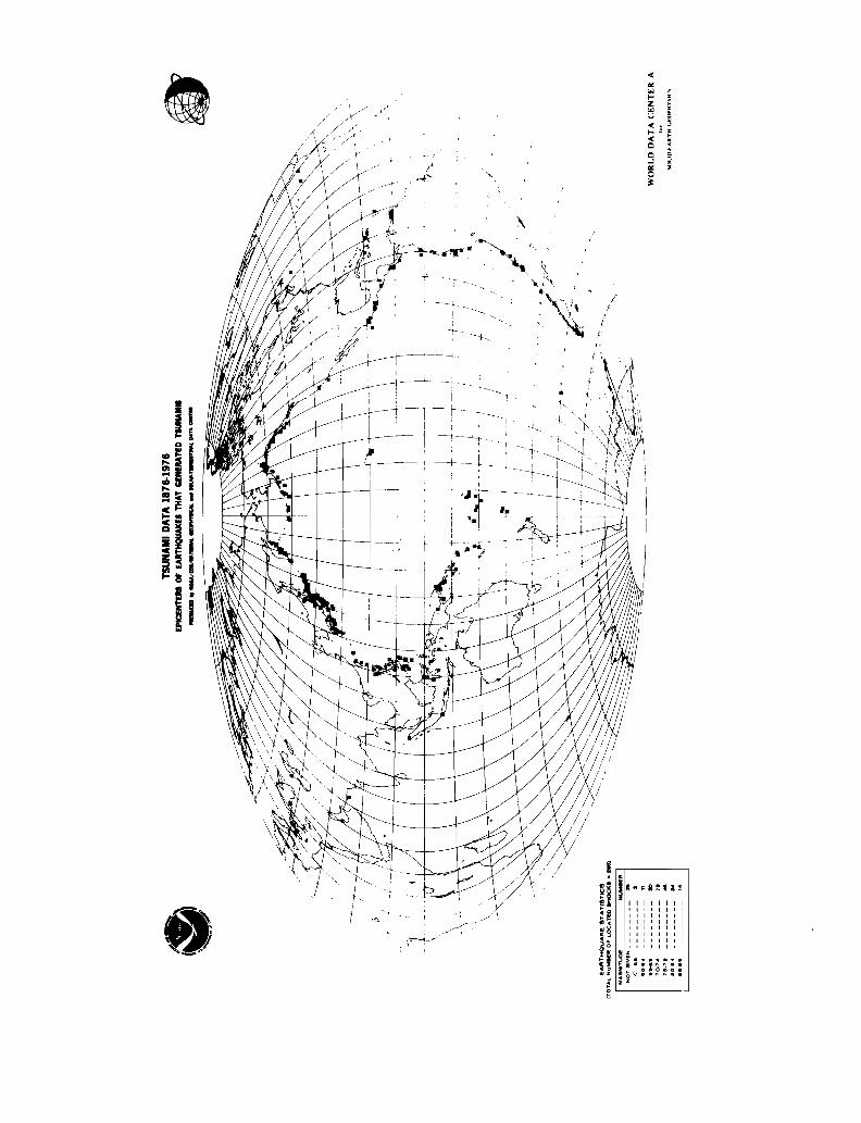
seismic sea wave, or tsunami, generated by large submarine earthquakes. Since
1850, more than 70,000 lives have been lost in the Pacific due to tsunami (1).
Today, several million people live or derive livelihood in tsunami hazard
zones in the Pacific.
Since 1965, Pacific nations subjected to tsunami hazards have mutually
benefited from the United Nations organization International Coordination
Group for the Tsunami Warning System in the Pacific.* In April 1982, this
group advanced the resolution that early warning systems be developed for
areas exposed to tsunami generated by local earthquakes. The present study
addresses the application of available technology, including satellites, for
significantly improving early tsunami warning along vulnerable coastal zones
in the Pacific basin. Specifically, a program is described which will test
and evaluate the utility of these technologies in tsunami hazard mitigation
in developing nations.
* See Appendix A for a relevant survey of international and national tsunamiorganizations and their interrelationships.
2
In describing locally generated warning systems, two time periods are
essential: the period, be it days, months, or years, prior to the tsunami
(pre-event stage) and the first hours after tsunami generation (real time
stage). During the pre-event stage, attention focuses on determining the
general extent of the tsunami threat in a coastal area and creating a viable
emergency evacuation plan for implementation at the time of the disaster.
During this time a program of public tsunami awareness and education can be
undertaken which can save many lives during the first few minutes of a locally
generated tsunami, when no mechanical warning system can be truly effective
and a threatened population must rely on its informed instincts. Once a
tsunami occurs (the real-time stage), a warning system capable of collecting
seismic and water level data, analyzing them, and disseminating hazard information
based on them is essential. Japan, USSR, and USA (Alaska and Hawaii) have
regional warning systems capable of reacting to a tsunami and issuing a local
warning about ten minutes after a local event (2). The other nations of the
Pacific, many of which are developing nations, are not as fortunate and must
rely on the Pacific Tsunami Warning System (operated at the Pacific Tsunami
Warning Center (PTWC) in Honolulu, Hawaii) for warning messages. Present
operating limitations prevent actual warnings from being disseminated to most
countries in less than one hour from the generation of a tsunami (3).
A gap, therefore, exists in the present warning structure. Developing
countries without a regional warning system cannot be alerted about tsunami
originating close to their shores until an hour after generation. The purpose
of this study is to examine existing U.S. technology to ascertain if an early
warning syst~m can be designed to fill this gap in nations with no regional or
national warning system. Specifically, the objective is to design a system
that can deliver earlier warnings to a developing country within the Pacific
3
or directly to isolated populations centers within ten minutes of tsunami
generation.
Thus, the rationale for the study presented in this document is the
transfer of existing u.s. technology to developing countries to supplement the
Pacific Tsunami Warning System during the first crucial hour of a tsunami.
These technologies can be partitioned into three categories: data
collection, data analysis, and information dissemination. Sections 2, 3, and
4 assess the existing technologies in data collection, analysis, and dissemi
nation which are applicable to the warning system and most appropriate for
transfer. Other U.S. technologies are available, but have certain drawbacks
because they are not easily adaptable to the existing tsunami system.
A number of criteria were used in selecting technologies for use in early
warning in local regions. Among these are reliability, compatibility, and
availability. The selection criteria also balanced the benefit of the hazard
reduction with cost of the system.
In Section 5, we present a conceptual system which synthesizes the tech
nologies discussed in Sections 2, 3, and 4. Finally, a demonstration program
is described in Section 6. The applicability of the demonstration program to
many areas of the Pacific can be shown. Implementation, including a site
survey and equipment installation in a test area, is a requisite step in
developing a satellite-based network throughout the Pacific basin with the
potential of saving lives and protecting property from the hazard of locally
generated tsunami. Recommendations are listed in Section 7. Acknowledgments
and references appear in Sections 8 and 9. Appendix A provides a complete
survey of international and national organizations interested in tsunami
hazards and their interorganizational relationships.
4
2. DATA COLLECTION
Since the beginning of the Pacific Tsunami Warning System in 1949, the
warning process has been initiated by seimic signals from large earthquakes.
The instruments used to detect these signals were largely those developed for
routine earthquake and tide monitoring programs. Recent significant advances
in data collection technologies have occurred which could be applied to early
tsunami warning (2). These include digital recorders, computers and microprocessor
technology, and satellite telemetry. Some of these technologies have been
used for experimental tsunami warning programs, nuclear-test monitoring, and
earthquake prediction programs in developed countries. The technology is,
therefore, available for use by developing countries for improving local
warnings.
The following is a brief review of the present status of water level and
seismic sensor technology relative to the tsunami early warning operations.
For this review, the following criteria were selected in assessing current
available instrumentation:
o Water level sensors should be capable of recording water level changes to
an accuracy of 1 cm for wave periods ranging from 3 to 90 minutes. They
should be able to remain on-scale during fluctuations of up to 7 meters beyond
tidal ranges at shallow water locations. The sensors should be able to transmit,
via satellite or hardwire to any location, digital data recorded at 3D-second
intervals independent of local power sources. The timing device for the
system should be accurate to within one minute in one year.
o Seismic sensors should be capable of recording accelerations to within
.01 g over a range of .1 g to 1.0 g. They should remain on-scale during

5
accelerations up to 1.0 g. Data from these sensors should be digitally processed
in real-time to activate a satellite transmission once a certain threshhold
has been exceeded. The sensor, processor, and transmitter should also operate
independently of local power sources. The system timing device should have an
accuracy of one minute in one year.
Equipment components available to create a data collection, processing,
and transmitting platform (with possible U.S. suppliers) include:
1) Tide gage (Metercraft; Progress Electronics of Oregon;
Handar Corp.)
2) Seismometer (Springnether; Kinemetrics; Geotech)
3) Microprocessors (North American Rockwell)
4) GOES receiver and transmitter (La Barge Corp; Motorola)
5) Solar panels with rechargeable batteries (Solarex)
Progress Electronics of Portland, Oregon, has stand-alone systems available
which meet tsunami warning water level criteria. Synergetics Corporation of
Boulder, Colorado, has a stand-alone seismic system available for earthquake
detection, processing, and transmitting from remote locations.
This evaluation leads to the conclusion that sensors can detect the
important parameters for tsunami warning and can transmit raw or processed
data via satellite. Indeed, some of these sensors have already been used in
test modes for improving the tsunami system. In particular, data from coastal
tide gages (bubbler type) and processed seismic data (short-period) have been
transmitted via the Qeostationary Qperational ~nvironmental ~atellite (GOES)
West system (4, 5). Data from other sensors, such as well-type tide gages,
short period and long period seismometers, have been transmitted in analog and
digital form to regional warning systems of Alaska, Hawaii, Japan, and USSR
(6). At all of these centers, computer-assisted data analysis is either
6
operational or in developmental stages (6). Thus, there are no known limitations
on existing sensor technology for immediate application to a satellite-based
early tsunami warning system.
One of the most exciting possibilities for improved early warning opera
tions is the automatic triggering capability of these sensors. Previous u.s.application of satellite technologies to the tsunami operation have focused
primarily on human-activated interrogation mode. For example, once an earth
quake has been detected and located by PTWC, tide gages are manually inter
rogated for verification of tsunami existence and determination of severity.
The principal drawback of this approach for early warning (10-60 minutes after
generation) is the time delay encountered in detecting the earthquake, assessing
data, and interrogating sensors. Currently, human-activated interrogating
systems introduce serious delays of up to one hour, which may be critical for
a developing country susceptible to a locally generated tsunami. It is recommended
that new satellite-based technology be integrated with the sensor-activated
mode to provide more rapid warning information to operational decision-makers
and people in charge at the disaster site. This total system is described in
more detail in Section 5.
In addition to real-time data collection, historical data on previous
tsunami in a particular location are essential to determine placement of
instruments, calibration of models, and formation of emergency planning. In
particular, historical information of tsunami arrival times, run-up levels,
and mitigation measures is necessary. Local bathymetric and topographic data
are also required to support model studies in threatened areas.
7
3. DATA ANALYSIS AND MODEL STUDIES
This section addresses the data analysis t data products and modeling
needed to provide the background for planning decisions t risk determ;nation t
and educational material development in support of awareness of primary tsunami
hazards and response to natural or system warnings.
One of the principal tools for tsunami data analysis is the use of models
of one type or another. These allow studies to be carried out during the
periods between actual events. Equally important is applying existing and
currently evolving techniques for modeling tsunami evolution for the improvement
of both the tsunami warning and the hazard mitigation capabilities. A useful
approach is the recognition that tsunami evolution can be described by three
phases.
o
o
o
generation and behavior in the immediate source area t
propagation away from the source area and toward coastlines t and
interaction (possibly destructive) with the environment near t at t
and on the shorelines.
This three-phase structure helps to point out/the different information require
ments for tsunami warning procedures and for hazard mitigation planning.
TSUNAMI WARNING
A system designed to warn people about a specific hazard should. have
several goals. It should be able to ascertain quite rapidly that a threat
ening hazard has developed t generate an assessment of the seriousness of the
threat t and communicate this information to threatened populations in suffi
cient time for them to take action to save their lives and protect their
8
property. A warning system must, in addition, be able to achieve these goals
repeatedly and accurately in order to establish its credibility and thus
maximize its effectiveness. In order to be an effective tool for saving lives
and property, the ideal tsunami warning system should be able to either generate
on its own or to tap into established sources of information concerning all
three phases of tsunami evolution.
HAZARD MITIGATION
The development of hazard mitigation plans takes place over a much longer
time scale than the tsunami warning process. Such plans might concentrate on
the most difficult phase of tsunami evolution--the coastal interaction phase.
These plans must take into account a wide variety of factors. These include
questions such as which portions of a coastal area are or have been most
severely threatened by tsunami? Where would the damage to life and property
be most significant? What are the probabilities of such events occurring in
ten years? fifty years? a century? What type of disaster relief preparations
should be made? How effective would measures such as strict zoning, land use
plans, increasingly stringent building codes, and coastal barrier construction
be in reducing the hazard?
TSUNAMI MODELS
The next question to be addressed is how tsunami models could help fill
requirements. Tsunami modeling, in simple terms, is an attempt to simulate or
approximate the behavior of a physical phenomenon. Tsunami models of one or
more of the three phases of evolution have been in use for the last several
decades. These models can be grouped into three categories:
Hydraulic models are attempts to recreate in wave tanks and with physical
models the processes observed in actual situations.
9
Analytical models reflect attempts to strip the complicated tsunami
process down to its basic physical elements and translate these into tractable
systems of equations. Functional solutions to these equations are then found.
The goal is not to faithfully recreate observations, but rather to combine the
various forcing mechanisms in an appropriate fashion, so that the model waves
behave in a manner qualitatively similar to physical waves.
Numerical models begin with sets of equations similar to those used in
analytical models. Computational, rather than functional, solutions are
sought, usually by means of digital computers. These solutions should closely
conform to observations.
All three types of models have been used successfully in examining the
various aspects of'tsunami evolution (7). Numerical models, because of their
great flexibility and relatively low cost, seem to have the greatest utility
for tsunami research (8, 9, 10).
Tsunami models can be quite useful in both hindcast and forecast modes.
That is, they can be used either to reconstruct what happened during a historical
event or to estimate what might possibly occur in the future. Both of these
uses provide a strong foundation of basic information to draw upon for both
long-term hazard planning and real-time warning.
In the hindcast mode, models can help to shed new light on what actually
happens when a tsunami occurs. They can be used to fill gaps in areas where
observational data is scarce. And they can be used to analyze ways in which
protective measures could have helped to reduce damage and destruction.
If models are to be used in this mode, a detailed compilation and analysis
of existing observational data must also be undertaken. The primary purpose
is to provide as much data as possible for verifying and calibrating model
results so that they conform closely to historic reality. A second
10
purpose is to place the tsunami (both real and model) into their proper historical
perspective in terms of frequency of occurrence and severity. This information
would be valuable on both regional and basin-wide scales by depicting the
nature of the threat for planning and education purposes.
In the forecast mode, models can be used to augment the historical data
base to estimate threat levels due to tsunami which have not yet happened.
This could include not only worst-case or once-in-200-year tsunami, but also
less severe, but quite possible, events. They can also provide travel time
information for augmenting existing charts.
In both modes, tsunami models can be applied to both long-term planning
and real-time warning.
Hazard Planning
Models can provide information to eliminate many omissions in our existing
knowledge. On a basin-wide scale they can be used to delineate areas of most
severe threat due to tsunami generated in specific regions. On a finer scale
they can be used to till in gaps in tide gage coverage along coastlines for
both historical and hypothetical events. This type of information can be used
to develop threat levels and probability-of-occurrence estimates in Pacific
coastal locations. Coastal models can be used to locate high-risk areas for
flooding and guide both land use requirements and building codes. Highly
detailed run-up models could even be used to develop scenarios for disaster
preparedness exercises.
Real Time Warning
Tsunami models can also play a key role in warning operations. If a
warning system were able to rapidly acquire information on the location,
magnitude, areal extent, and tsunami potential of an earthquake, an existing
data base of similar cases could identify threat probabilities throughout the
11
Pacific. The most useful product, in terms of determining appropriate response,
would be to supplement notice that a tsunami has been generated with estimates
of its severity.
Data Products
A useful product for public information could be a map illustrating the
tsunami occurrences and effect within the Pacific basin. This would summarize
in a visual form the history of destructive tsunami on a Pacific-wide and
local basis. A revised travel time chart for local and Pacific basin tsunami
could be prepared using new digital bathymetric data for any location.
In order to provide the data needed to support later modeling, analysis
and dissemination activities, local coastal bathymetry and elevations,
tsunami effects, run-up and arrival time data and information on local
disaster warning infrastructure must be gathered.
12
4. DISSEMINATION OF INFORMATION
The Pacific Tsunami Warning System detects major earthquakes in the
Pacific region, evaluates the earthquake tsunami potential in terms of epicenter
and Richter scale magnitude, determines if a tsunami has been generated, and
issues appropriate warnings and information to minimize the hazards of tsunami.
The international monitoring system is composed of twenty-two seismic stations
and approximately 50 tide stations throughout the Pacific Ocean. The international
warning system employs teletypewriter and voice communication links to acquire
data and disseminate tsunami information to seventeen nations. Transmission
times range from 10 minutes to one hour, depending on the efficiency of
communication relay points. Regional warning systems for locally generated
tsunami exist for Hawaii, Alaska, Japan, and USSR. These monitoring systems
are real-time links from seismometers and tide gages to the respective centers
(6). Local tsunami warnings in these systems may be issued on the basis of
earthquake information alone.
In general, warnings delivered by these centers include earthquake locations
(±50 km), earthquake Richter scale magnitude (±.3), tsunami arrival (±20 min),
and reports of tsunami wave heights as recorded by tide gages (6). The earthquake
parameters and tsunami arrival times throughout the Pacific are usually disseminated
by PTWC to the 54 international warning points within one hour after the
occurrence of an earthquake. The time of receipt of tsunami wave reports at
PTWC varies with the travel time of the tsunami from its origin to the tide
gages, the dependab"ility of equipment and observers, and the communication
links.
13
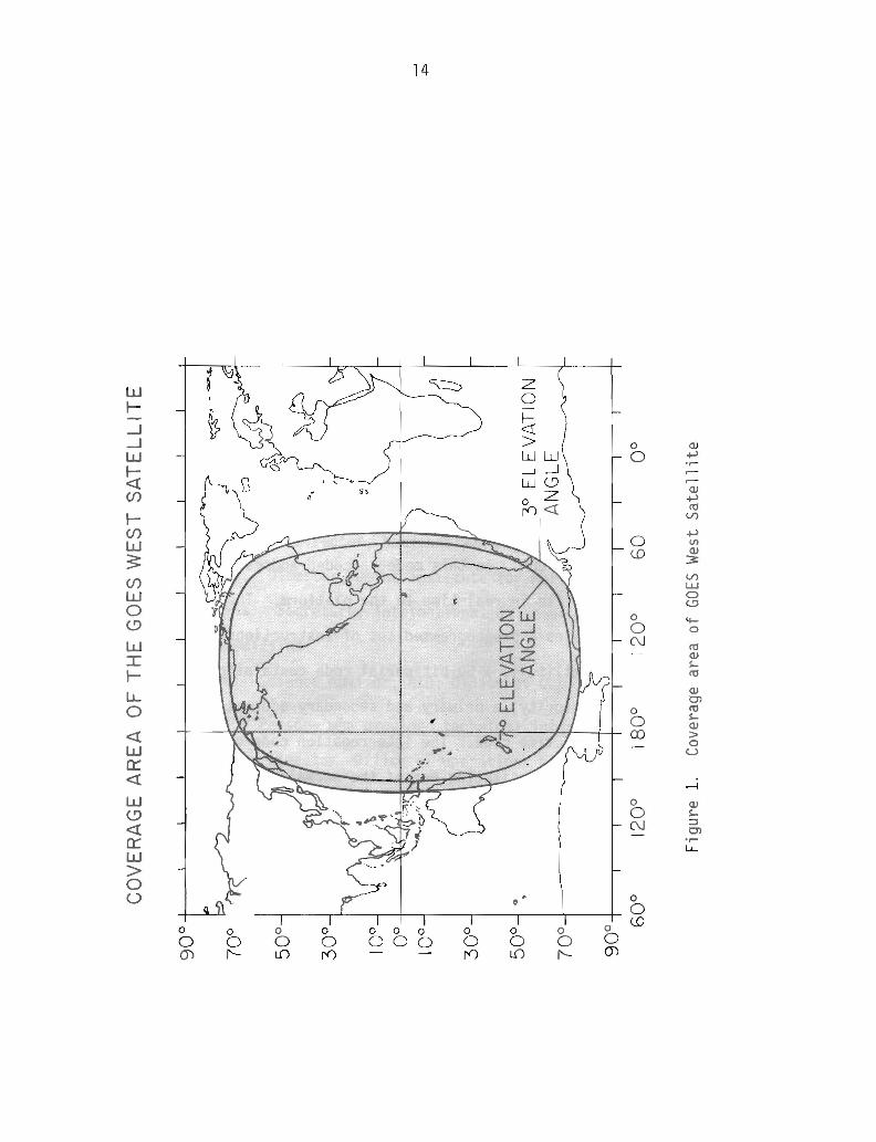
Development of satellite communication offers significant opportunities
for both collecting and disseminating warning information. NOAA's Geosta
tionary Observational Environmental Satellite (GOES) provides a transmission
pattern for the whole eastern Pacific (Figure 1).* The GOES operating system
includes a data collection system (for use with sensors described in Section
2) that can receive information from a sensor and relay this information
through the satellite to a central point for distribution. For Pacific-wide
tsunami warning application, the data would be transmitted to the command and
Qata ~cquisition station (CDA) at Wallops Island, Virginia, then retransmitted
to the PTWC. The time of transmission from sensor to PTWC can be as short as
one minute in II rea l time. 1I
The GOES West operating system can also interrogate remote sensors by
command initiation from CDA. In this mode, a coded address is initiated and
transmitted via satellite in real-time to the platform. The platform receives
a command that activates a preprogrammed set of instructions. Normally, the
command from the satellite is a 50-bit serial code containing an identifier, a
platform number, a priority, a primary and secondary address, a standard
validation code, and a time code. The interrQgation code can serve as an
early warning alert by substituting one of the normal codes through modification
of the operating system at CDA (11). For more technical details of the GOES
communication system, see Appendix B.
A Disaster Alert System
Ideally, for a disaster alert system, a comprehensive message describing
the potential disaster conditions, parameters, and prognosis is desirable. But
in real emergencies a minimum amount of factual material is available to issue
* Failure of the imaging scanner on the GOES West satellite Nov. 25, 1982,did not affect the communications capability. The following discussionsabout the GOES West are still valid.
CO
VE
RA
GE
AR
EA
OF
TH
EG
OE
SW
ES
TS
AT
EL
LIT
E
--'
+>
0°
60
;/--
3°
EL
EV
AT
ION
AN
GLE
12
0°
18
00
120°
90
°
70
°
50
°
30
°
10°
0°
10°
30
° 5ool·
·7
0°
90
° 60
°
Fig
ure
1.C
over
age
area
ofGO
ESW
est
Sa
tell
ite
15
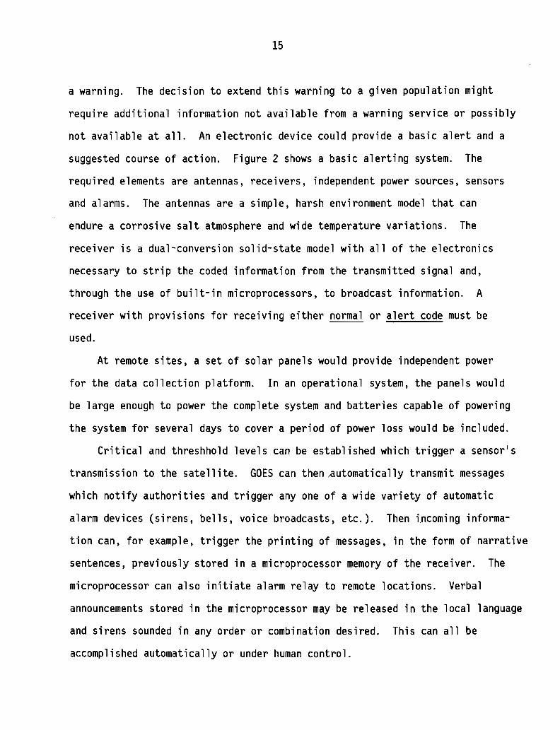
a warning. The decision to extend this warning to a given population might
require additional information not available from a warning service or possibly
not available at all. An electronic device could provide a basic alert and a
suggested course of action. Figure 2 shows a basic alerting system. The
required elements are antennas, receivers, independent power sources, sensors
and alarms. The antennas are a simple, harsh environment model that can
endure a corrosive salt atmosphere and wide temperature variations. The
receiver is a dual-conversion solid-state model with all of the electronics
necessary to strip the coded information from the transmitted signal and,
through the use of built-in microprocessors, to broadcast information. A
receiver with provisions for receiving either normal or alert code must be
used.
At remote sites, a set of solar panels would provide independent power
for the data collection platform. In an operational system, the panels would
be large enough to power the complete system and batteries capable of powering
the system for several days to cover a period of power loss would be included.
Critical and threshhold levels can be established which trigger a sensor's
transmission to the satellite. GOES can then ~utomatically transmit messages
which notify authorities and trigger anyone of a wide variety of automatic
alarm devices (sirens, bells, voice broadcasts, etc.). Then incoming informa
tion can, for example, trigger the printing of messages, in the form of narrative
sentences, previously stored in a microprocessor memory of the receiver. The
microprocessor can also initiate alarm relay to remote locations. Verbal
announcements stored in the microprocessor may be released in the local language
and sirens sounded in any order or combination desired. This can all be
accomplished automatically or under human control.
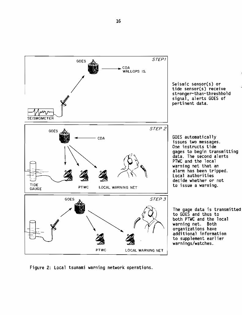
16
GOES"___.... CDA
WALLOPS IS.
STEP!
/ Seismic sensor(s) ortide sensor(s) receivestronger-than-threshholdsignal, alerts GOES ofperti nent data.
The gage data is transmittedto GOES and thus toboth PTWC and the localwarning net. Bothorganizations haveadditional informationto supplement earlierwarnings/watches.
GOES automaticallyissues two messages.One instructs tidegages to begin transmittingdata. The second alertsPTWC and the localwarning net that analarm has been tripped.Local authoritiesdecide whether or notto issue a warning.
STEP 3
STEP 2
PTWC LOCAL WARNING NET
GOESe/ \
~
GOES~
• .. CDA
TIDEGAUGE
PTWC LOCAL WARNING NET
Figure 2: Local tsunami warning network operations.
17
Thus, by utilizing existing technologies with slight modification, an
early warning event-activated system can be installed in disaster-prone devel
oping nations without regional warning systems. Such a system could reduce
alerting time from one hour to as little as one minute. The time-saving alert
coupled with a well designed local contingency plan could save many lives.

18
5. SYNTHESIS OF TECHNOLOGIES AVAILABLE FOR TRANSFER
The previous three sections have shown that the technology exists to
improve estimates of tsunami hazards and to establish rapid dissemination of
localized early warnings. Appropriate configuration of these elements will
constitute a conceptual model that represents a significant advance in early
tsunami warning. In terms of previous three sections, the conceptual model
can be described in the following fashion:
Data Collection -
A. Pre-event: historical data on tsunami run-up, times of arrivals and
effects will assist in emergency planning and model verification. Bathymetric
and topographic data are necessary inputs for model simulations.
B. Real-time: data collection will be initiated by the triggering of
seismic or water level devices of the tsunami system. Reports from water-level
sensors are still required to determine the existence and severity of tsunami.
Both sensor types must be in communication with PTWC. It is desirable, but
not necessary, that the sensors be directly linked to a local warning network
in addition to the satellite link.
Data Analysis -
A. Pre-event: historical data analysis, coupled with numerical models,
provides estimates of potential inundation levels for planning purposes.
These investigations are essential to designate hazard areas and safety zones
for disaster planning.
B. Real-time: real-time data can be used to update warning information
calculated in the pre-event data analysis. They can also be used to monitor
and continuously refine warning information as the tsunami propagates through
out the Pacific.
19
Dissemination -
A. Pre-event: emergency preparedness will require the establishment of
a local infrastructure to respond to a tsunami. Public education is the
foundation of proper response to a tsunami alert. Dissemination of informa
tion on the procedures and dangers of tsunami will take the form of workshops,
media coverage, school programs, and other vehicles to keep the pUblic aware
of the hazard.
B. Real time: or near-real-time dissemination of warnings for developing
countries can be accomplished by the application of satellite technology as
described in Section 4.
With the conceptual framework as a guide, a demonstration program could
be implemented for one population center to demonstrate the utility of the
system. This program is described in detail in Section 6. The products derived
from this demonstration are transferrable for use in the Japanese GOES system
and the Indonesia PALAPA system, thereby providing a proven technology to
other countries interested in tsunami hazard mitigation but outside the range
of GOES West. Such a program will provide data to PTWC much more rapidly,
thus allowing for earlier a11rting of the Pacific System. It will also foster
cooperation among agencies that have an interest in U.S. tsunami hazards
mitigation.*
This conceptual model should be considered a generalized framework. As
such, it has inherent limitations because localized details have been omitted.
Each application of this model must reflect the geophysical, oceanographic,
and socio-political character of the specific site. The geophysical characteristic~
will determine seismic instrument design and placement; oceanographic characteristil
* See Appendix A for U.S. organizations concerned with tsunami hazards.
20
will determine water level gauge placement and design; and socio-political
characteristics will determine the emergency system design. The successful
integration of these factors is a difficult task which must be accomplished on
a case-by-case basis. The lack of a detailed elaboration of these factors is
not meant to minimize their impact; such a discussion, however, is well beyond
the scope of this feasibility study.
21
6. THRUST PROGRAM
The conceptual model described in Section 5 can quite readily be turned
into a demonstration program~-!sunami ~azard geduction ~tilizing ~ystem !echnology
(THRUST)--to mitigate tsunami hazards in the Pacific Ocean. The first step of
this program is to test the conceptual model described in Section 5 at one
population center in a developing country.
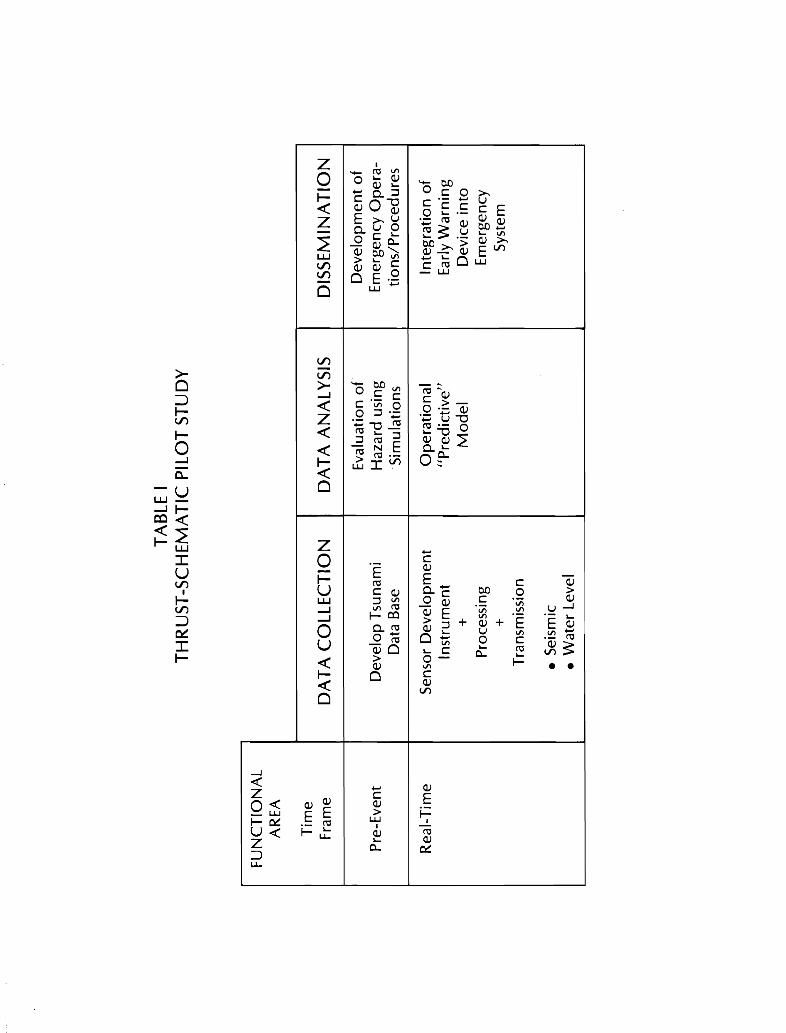
Table I illustrates the THRUST pilot study. The study is subdivided into
the three functional areas of data collection t data analysis t and information
dissemination; each area is partitioned into pre-event and real-time frames.
Thus t one could interpret the first row of the matrix as development of the
emergency operating system that is activated by the real-time second row. Both
time frames must be considered for a system that will reduce tsunami hazards.
During the pre-event stage a data base would be developed to provide
historical information on tsunami run-UPt arrival times and tsunami impacts.
Additional data would be collected on the bathymetry of the local coastline t
the topography of the land t and local tidal ranges. These data would be used
to simulate historical tsunami events. The historical data would help vali
date and calibrate the numerical model while information on the physical
morphology would be used to construct the model. Once the numerical model has
been verified (simulations closely resemble historical data)t then hypothetical
simulations will be conducted for worst case scenarios. The selection of
scenarios will b~ based upon geophysical information relating to the most
probable earthquake1s areal extent t magnitude t and vertical displacement which
could occur close to the test area. The combination of historical data and
model simulations provides an extended data base from which to to create
emergency operating plans. Although this extended data base has drawbacks (it
22
depends on the quantity and quality of the real data base), it represents the
best technique of supplying data where none exists. From these data, zones of
hazard and safety can be constructed and evacuation plans established. In
many cases, these data can also provide building code guidelines.
An eartl Jake activates a seismic instrument. This instrument then
transmits a signal to the GOES satellite system (satellite and COA) that
responds by automatically transmitting an alert code to an alarm device at the
warning site designated by local authorities. The alarm device instantly
responds by initiating a set of prerecorded instructions based upon the emergency
plans established before the tsunami. A human will make the final determination
about issuing a tsunami warning based upon predetermined criteria. Thus, a
human will make the decision, and he will have enough information within
5 minutes of the earthquake to make such a decision intelligently. In addition
to the early alert signal from the GOES satellite, other signals are sent to
interrogate tide gages about the earthquake source. These water level data
are sent to PTWC and to the local authorities for faster confirmation of
tsunami activity. The impact of the THRUST program will be an early warning
system for the local population near the source and faster dissemination
Pacific wide by PTWC.
In choosing population centers for a pilot demonstration, consideration
was given to tsunami hazard potential, access to GOES West satellite, and
national commitment to the program. Using these criteria, two cities in two
South American countries were selected (Lima, Peru, and Valparaiso, Chile).
It is recommended that only one site be chosen for the pilot study, but two
are offered in case one country is not suitable. A site survey team should
evaluate both locations and determine the host country on the basis of technical
capacity and institutional commitment to implementing the demonstration and
maintaining continued operations.
TAB
LEI
TH
RU
ST
-SC
HE
MA
TIC
PIL
OT
ST
UD
Y
FU
NC
TIO
NA
LA
RE
A
Tim
eF
ram
eD
AT
AC
OL
LE
CT
ION
DA
TA
AN
AL
YS
ISD
ISS
EM
INA
TIO
N
Eva
luat
ion
of
De
velo
pm
en
to
fP
re-E
vent
De
velo
pT
suna
mi
Haz
ard
usin
gE
mer
genc
yO
pe
ra-
Dat
aB
ase
Sim
ula
tion
sti
on
s/P
roce
dur
es
Rea
l-T
ime
Sen
sor
De
velo
pm
en
tO
pe
rati
on
al
Inte
gra
tio
no
fIn
stru
me
nt
"Pre
dic
tive
"E
arly
Wa
rnin
g+
Mo
de
lD
evi
cein
toP
roce
ssin
gE
mer
genc
y+
Sys
tem
Tra
nsm
issi
on
•S
eism
ic•
Wa
ter
Leve
l

23
7. RECOMMENDATIONS
In recognizing AID/OFDA's role and responsibility in coordinating inter
national disaster assistance, including prediction and early warning, it is
recommended that
1) An ongoing program in tsunami hazards' reduction for developing
countries of the Pacific basin be established in AID/OFDA,
2) AID/OFDA's early warning program strategy with respect to tsunami
hazard be strengthened through support of a THRUST pilot program
explained in the preceding sections and
3) AID/OFDA's early warning program strategy be further strengthened
through public education programs that promote proper understanding
and reaction to tsunami warnings.
24
8. ACKNOWLEDGMENTS
This study was funded by the Agency for International Development1s Office
of U.S. Foreign Disaster Assistance whose support is appreciated.
The authors gratefully acknowledge the contributions of the following
persons who gave of their important time to improve this study.
Members present at the November 17, 1982 Workshop
Mr. G. Dohler: Chairman, International Co-ordinating Group for the Tsunami
Warning in the Pacific
Dr. G. Pararas-Carayannis: Director, International Tsunami Information Center
Mr. G. Burton: Director, Pacific Tsunami Warning Center
Mr. R. H. Hagemeyer: Director, National Weather Service Pacific Region
Dr. Dennis Moore: Director, Joint Institute for Marine and Atmospheric Research
Dr. Harold Loomis: Secretary, International Union of Geodesy and Geophysics
Tsunami Commission
Mr. Paul Krumpe: Science Advisor, AID, Office of U.S. Foreign Disaster Assistance
Persons who provided technical information
Mr. Gordon Vaeth: Director, Office of Operations National Environmental
Satellite Services
Mr. Mickey Moss: Assistant Chief, Pacific Tides Party
Mr. Harold Clark: Engineer, Alberquerque Seismological Laboratory
Mr. Charles Vermillion: Engineer, National Aeronautical and Space Administration
Reviewers of Draft Document
All of the above.
Dr. Glenn Flittner: Chief Ocean Services Division, National Weather Service
Dr. Jimmy Larsen: Research Oceanographer, Pacific Marine Environmental Laboratory
Ms. Jean Chatfield: Editor, Pacific Marine Environmental Laboratory
25
9. REFERENCES
1. Iida, K., D. Cox, and G. Pararas-Carayannis, Preliminary Catalog of
Tsunamis Occurring in the Pacific Ocean. H.I.G. University of Hawaii,
1967.
2. Bernard, E.N. and Richard Goulet, Tsunami Research Opportunities.
National Science Foundation, Washington, D.C., 1981.
3. Spaeth, M.G., Communication Plan for Tsunami Warning System. U.S. Dept.
of Commerce, Silver Spring, MD, 1975.
4. Clark, H.E., IITsunami Alerting System. 1I Earthquake Information Bulletin.
USGS, 11:4, 132-7, 1979.
5. Van Dorn, W., IIInstrumentation and Observations. II Tsunamis: Proceedings
of the National Science Foundation Workshop, Tetra Tech, Inc., Pasadena,
CA, 1979.
6. Bernard, E.N., liOn Upgrading the U.S. National Tsunami Warning Center,1I
Proceedings of IUGG Tsunami Symposium, Canberra, Australia, 1979.
7. Houston, J.R., State-of-the-Art for Assessing Earthquake Hazards in the
United States: Tsunamis, Seiches, and Landslide - Induced Water Waves.
Misc. Paper S-73-1 (No. 15 of a series). U.S. Army Engineer Waterways
Experiment Station, Geotech. Lab., Vicksburg, Miss. NTIS: ADA079917, 1979.
26
8. , R.D. Carver, and D.G. Markle, Tsunami-wave elevation
frequency-of-occurrence for the Hawaiian Islands, TR-H-77-16, U.S. Army
Engineer Waterways Experiment Station, Vicksburg, Miss., NTIS: ADA045023,
1977.
9. Aida, I., Reliability of a tsunami source model derived from fault parameters,
J. Phgs. Earth, 26, 57-63, 1978.
10. Hebenstreit, G.T., United States foreign assistance program on tsunami
hazard. Tech. Note SAI/OPD TN-82-801-01. Ocean Phys. Div., Science
Applications, Inc. McLean, VA. NTIS PB83-102673, 1982.
11. Vaeth, S.G., Monitoring the Volcanic IIRing of Fire ll- A role for
Satellite, Tsunami Newsletter, 5, 3, 1-7, 1982.
27
Appendix A
Tsunami Organizational Relationships
28
Tsunami Organizational Relationships
Tsunami related activities and responsibilities are scattered through a
number of international and national governmental and scientific organizations.
They range from scientific research and engineering to hazard mitigation and
warning activities.
On the pages 33-36 is a schematic which attempts to identify the key
international and U.S. bodies and to show their relationships. There are also
substantial national organizations in Japan and the USSR which are not identified.
The organizations indexed by numbers in the upper left corner are described as
follows.
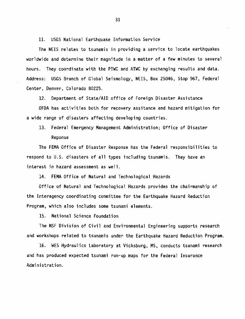
I. Internat iona1 Programs
1. International Coordination Group for the Tsunami Warning System in
the Pacific (ITSU).
ITSU consists of representatives of 22 Pacific Basin nations. It meets
about every other year to 1) effect liaison among participating countries at
the technical level, 2) ensure exchange of information regarding techniques of
tsunami forecasting, 3) coordinate with 10C, WMO, and IUGG and 4) provide
essential secretarial services for 10C. It makes recommendations regarding
improvements in the system which require action by member states. Contact can
be made through the Intergovernmental Oceanographic Commission, UNESCO, 7,
Place de Fortenoy 75700 Paris.
2. IUGG Tsunami Commission
IUGG Tsunami Commission promotes tsunami research and applications by
providing a forum to hold meetings and symposia and otherwise provide for the
exchange of scientific information about tsunamis, and for providing advice on
tsunami problems to appropriate organizations. The tsunami commission is
29
sponsored jointly by IASPEI and IAPSO It meets every two years alternating
with the IUGG General Assembly every four years and separate symposia in the
interim. One of its roles is to review the World Data Center Guide to
International Data Exchange for tsunami data. As with most scientific organization
the chairmanship and secretariat change regularly. Contact can be made through
the ICSU Secretariat, 51 Blvd de Montmorency, 75016 Paris, France.
II. National Programs
3. UJNR Task Committee on Storm Surge and Tsunamis
This Task Committee meets annually with the UJNR Panel on Wind and Seismic
Effects to present technical findings and review activities by government
agencies in the two countries. Recommendations for joint activities or data
exchanges are made. Contact can be made through Bureau of Standards, Structures
Division, Gaithersburg, Md., which provides the focus for the U.S. side.
4. US/USSR System of Simultaneous Warning on Tsunami
This activity is part of the US/USSR Environmental Protection Agreement.
Members from the U.S. and USSR meet occasion1y to develop agreements for joint
projects. The U.S. Project Leader is Dr. Eddie Bernard, Pacific Marine Environment
Laboratory, 3711 15th Avenue Northeast, Seattl~, Washington 98105.
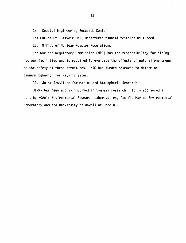
III. U.S. Government
5. Marine Services Branch
This branch currently provides the staff support for NWS Headquarters in
Washington for coordinating the tsunami warning program. Dr. Glenn F1ittner,
head of the branch, is the U.S. national contact to ITSU.
6. Alaska Tsunami Warning Center
This activity provides tsunami warning for the Alaskan and U.S. West
Coast Region by centrally recording seismometers and tide gauges at its Palmer,
Alaska facility. It coordinates closely with the Pacific Tsunami Warning
30
Center and the USGS National Earthquake Information Service.
7. The Pacific Tsunami Warning Center
The PTWC at Ewa Beach, Oahu, is the hub of the Pacific Tsunami Warning
Service and relies on locally recording seismometers and communicated seismic
and tide observations from around the Pacific to provide tsunami warnings to
participating organizations around the Pacific. It also provides local warnings
for the State of Hawaii.
8. International Tsunami Information Center
The ITIC performs a coordinating, monitoring, and advisory role to the
Member States of the ITSU relative to the tsunami warning system and tsunami
hazards. It publishes the informative IITsunami Newsletter" several t"imes each
year. It provides technical advice to developing countries, welcomes guest
workers, and develops educational meterial. It is operated by the NWS for the
10C. Address: P.O. Box 50027, Honolulu, Hawaii 96850.
9. Pacific Marine Environmental Laboratory
PMEL engages in research relative to tsunamis and supports research at
the Joint Institute for Marine and Atmospheric Research (JIMAR) at the University
of Hawaii. (Address: 3711 15th Ave. N.E., Seattle, WA 98105)
10. World Data Center-A
WDC-A operates under general guidelines recommended by relevant inter
national scientific bodies. In the field of tsunami, this is the IUGG Tsunami
Commission. The WDC-A collects information on the occurrence and effects of
tsunamis including seismic and mareographic records, photography, and histories.
It produces data products such as publications and maps. Guest workers are
welcome. Address: WDC-A for Tsunamis, NOAAIIIGCI, 320 Broadway, Boulder,
Colorado 80303.
31
11. USGS National Earthquake Information Service
The NElS relates to tsunamis in providing a service to locate earthquakes
worldwide and determine their magnitude in a matter of a few minutes to several
hours. They coordinate with the PTWC and ATWC by exchanging results and data.
Address: USGS Branch of Global Seismology, NElS, Box 25046, Stop 967, Federal
Center, Denver, Colorado 80225.
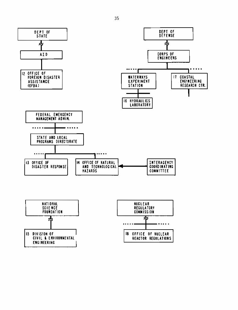
12. Department of State/AID office of Foreign Disaster Assistance
OFDA has activities both for recovery assitance and hazard mitigation for
a wide range of disasters affecting developing countries.
13. Federal Emergency Management Administration; Office of Disaster
Reponse
The FEMA Office of Disaster Response has the Federal responsibilities to
respond to U.S. disasters of all types including tsunamis. They have an
interest in hazard assessment as well.
14. FEMA Office of Natural and Technological Hazards
Office of Natural and Technological Hazards provides the chairmanship of
the Interagency coordinating committee for the Earthquake Hazard Reduction
Program, which also includes some tsunami elements.
15. National Science Foundation
The NSF Division of Civil and Environmental Engineering supports research
and workshops related to tsunamis under the Earthquake Hazard Reduction Program.
16. WES Hydraulics Laboratory at Vicksburg, MS, conducts tsunami research
and has produced expected tsunami run-up maps for the Federal Insurance
Administration.
32
17. Coastal Engineering Research Center
The COE at Ft. Belvoir t MDt undertakes tsunami research as funded.
18. Office of Nuclear Reactor Regulations
The Nuclear Regulatory Commission (NRC) has the responsibility for siting
nuclear facilities and is required to evaluate the effects of natural phenomena
on the safety of these structures. NRC has funded research to determine
tsunami behavior for Pacific sites.
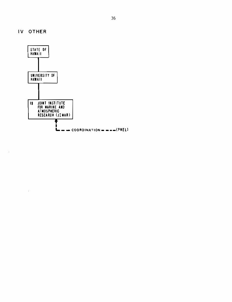
19. Joint Institute for Marine and Atmospheric Research
JIMAR has been and is involved in tsunami research. It is sponsored in
part by NOAAls Environmental Research Laboratories, Pacific Marine Environmental
Laboratory and the University of Hawaii at Honolulu.
33
ACTIVITIES RELATED TO TSUNAMIS
I INTERNATIONAL
IN TERGOV ERNMENTAL
•• ••• •••••
IOCINTERGOVERNMENTALOCEANOGRAPHIC CONN ISSION
1 ITSUINT'l COORDINATIONGROUP FOR THETSUNAMI WARNINGSYSTEM IN THE PAC IF IC
(22 NATIONAL REPRESENTATIVES)
Ir NATIONAL PROGRAMS
SCIENTIFIC
ICSUINT'L COUNCIL OFSCIENTIF IC UNIONS
..... •••••
I UGG!NT'l UN ION OFGEODESY AND GEOPHYSICS
.••. -I •••••
JASPEI lAPSOIIH'L ASSOC OF INT'L ASSOC OFSEISMOLOGY AND PHYSICS PHYSICAL SCIENCESOF THE EARTH', INTERIOR OF THE OCE ANS
1 I--., III 2 TSUNAMIL:0ORDINATION
----~COMMISSION
A. UJtIR U.S./JAPAN COOPERATIVE PROGRAM IN NATURAL RESOURCES
PANEL ON WIND AND SEISMIC EFFECTS
3 TASK COMMITTEE ON STORM SURGE AND TSUNAMIS
B. U.S./U.S.S.R. ENVIRONMENTAL PROTECTION AGREEMENT
4 SYSTE M OF SIMU LTUEOUS 'ARN ING ON TSUIIA If IS
34
m U.S. GOVERNMENT
DEPT OFCOMMERCE
I.....- ......- .....I
NOAANAT'L OCEANIC ANDATMOSPHERIC ADM IN.
I.....'P"'----_..---.....---_.....
..... .....
DEPT OFINTERIOR
-......I
.....U.S. GEOlOG ICAL
SURVEY
..... .....OFFICE OFEARTHQUAKESTUDIES
..... • ••••
II NAT'L EARTHQUAKEINFORMATIONSERVICE (NElS)
at
NAT'l GEOPHYSICALDATA CENTER
NAT'l ENVIRONMENTALSATELLITE, DATA ANDINFORMAT ION SERVICE
.....- .....__ .....
9 PACIFICMARINEENV IRONNENTALlABORATORYIPMEL)
OFFICE OFOCEANIC ANDATMOSPHERICRESEARCH
IPACIFICREGION
ALASKAREGION
I
NA TlONAlWEATHERSERVICE
s::~r-------,5 MARINE -
SERVICESBRANCH
I II I
~ :'0.2R.2I!~.'~!~~J
10 WORLD DATACENTER -A(WOC -A )
f
8 ITICINT'l TSLINAM IINFO. CTR.
6 ALASKAN 7 PACIFICTSUNAMI TSUNAMIWARNING WARNINGCENTER I CENTER
(PTWC)
1 '. ~ ofI II I I II' I II L .J I
I I• IL .1 ~~~I~A!!O~ ....
DE PT OFSTATE
12 OFFICE OFFOREIGN DISASTERASSISTANCECOFDA)
35
DEPT OFDEFENSE
tCORPS OFENGI NEERS
I.. ..-. .....I
WATERWAYS 11 COASTALEXPERIMENT .ENGINEERINGSTAT ION RESEARCH CTR.
I II16 HYDRAU L1CS I
LABORATORY
FEDERAL EMERGENCYMANAGEMENT ADMIN.
.. .. . I .....I
STATE AND LOCALPROGRAMS DIRECTORATE
..... II I
.....13 OFFICE OF 14 OFFICE OF NATURAL - INTERAGENCY
DISASTER RESPONSE AND TECHNOLOGICAL - COORDINATINGHAZARDS COMM ITTEE
NATIONALSCIE NCEFOUNDATION
:: ~
15 DIV ISION OF ICIVIL 1 ENVIRONMENTALENGINEERING I
NUCLEARREGU LA TORYCOMMISSION
~~.. ... .....18 OFF IC E OF NUCLEAR
RfACTOR REGULATIONS
I V OTHER
36
STATE OFHAIAII
UNIVERSITY OFHAIAII
19 JOINT INSTITUTEFOR MAR 1NE ANDATMOSPHERICRESEA RC H CJI MAR )
tIL. __ COORDINATION- CPMELl
37
Appendix B
The Role of the GOES Satellite
38
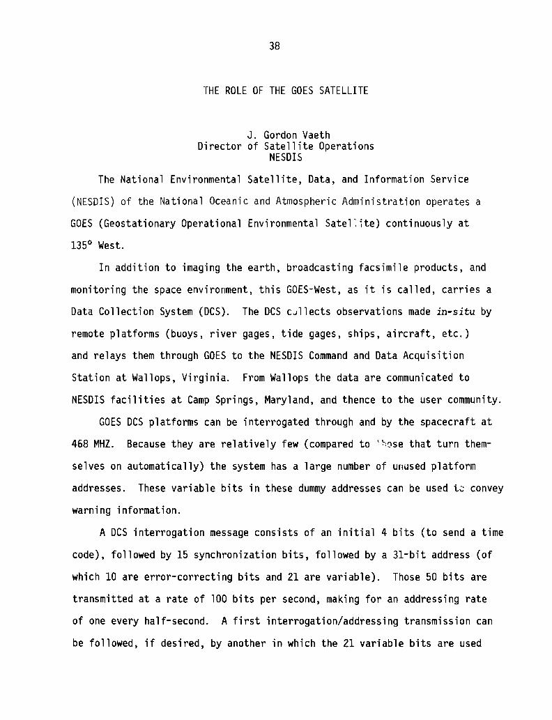
THE ROLE OF THE GOES SATELLITE
J. Gordon VaethDirector of Satellite Operations
NESDIS
The National Environmental Satellite, Data, and Information Service
(NESDIS) of the National Oceanic and Atmospheric Administration operates a
GOES (Geostationary Operational Environmental Satel~1te) continuously at
1350 West.
In addition to imaging the earth, broadcasting facsimile products, and
monitoring the space environment, this GOES-West, as it is called, carries a
Data Collection System (DCS). The DCS c~llects observations made in-situ by
remote platforms (buoys, river gages, tide gages, ships, aircraft, etc.)
and relays them through GOES to the NESDIS Command and Data Acquisition
Station at Wallops, Virginia. From Wallops the data are communicated to
NESDIS facilities at Camp Springs, Maryland, and thence to the user community.
GOES DCS platforms can be interrogated through and by the spacecraft at
468 MHZ. Because they are relatively few (compared to t~ose that turn them
selves on automatically) the system has a large number of unused platform
addresses. These variable bits in these dummy addresses can be used t~ convey
warning information.
A DCS interrogation message consists of an initial 4 bits (to send a time
code), followed by 15 synchronization bits, followed by a 31-bit address (of
which 10 are error-correcting bits and 21 are variable). Those 50 bits are
transmitted at a rate of 100 bits per second, making for an addressing rate
of one every half-second. A first interrogation/addressing transmission can
be followed, if desired, by another in which the 21 variable bits are used
39
to command the station addressed to do something--which for tsunami warning
would be to select a certain "canned" or stored watch or warning message from
a computer and display or type it out.
The warning receiving station activated by these interrogations would be
a modification of an existing off-the-shelf GOES Time Coder Receiver, a printer,
and some type of simple message storage device. A demonstration of the basic
equipment, showing its ability to display and print out time and station
addresses can be made.
The actual operation scenario remains to be determined. A logical sequence
for test and demonstration could consist of the following:
A
(a) A seismometer platform senses an event above a pre-set thresh
hold level, automatically and immediately reports on a dedicated
tsunami warning DCS channel, then continues to report its observa
tions at pre-selected intervals (it would also turn itself on
once a day for a readiness check).
(b) upon receiving this event report via Wallops, the DCS Data
Handling subsystem at Camp Springs would select the proper
advisory message number and insert it into the outgoing GOES DCS
interrogations stream in the 21 variable bits of the address of
the warning receiving stations along, for example, the Chilean
or Peruvian coasts.
(c) the receiving station responding to the interrogation/command,
would then call up the proper message, display, and print it.
40
B
(d) next tide gages would have to be activated to confirm whether
a tsunami has been generated; this can be done in two ways:
(1) receipt of the original seismic event information by
the DeS data handling subsystem could be programmed auto
matically to trigger IIturn on and reporV' interrogation
messages to the gages.
(2) the gages could operate on a continuous lion the readyll
status, awaiting a greater than threshold event that
would cause them to activate and report.
(e) depending upon the tide gage reports, the DeS Data Handling
subsystem would insert in the command stream to the warning
receiving station the number or numbers of the Warning/Evacua
tion messages that it should call up from its memory, display,
and print out.
C
(f) if would then be up to the local authorities to act on that
information.
Some comments on the above.
(1) The reporting seismic and tide gage stations could be designed to
provide quantitative measurement data or (for maximum simplicity
and low cost) simply register the fact that a greater-than
thresshold event has taken place at its location.
(2) non-interrogated platforms would be cheaper and more reliable
(because they have no receivers in them).
41
(3) Although the above is based on conveying warning information via
DeS platform interrogation addresses, an alternate mode is
possible--using the first 4 bits of every interrogation message
when those 4 bits are not required to broadcast the time code.
This would require a time-sharing arrangement with the National
Bureau of Standards.
(4) But most importantly: somewhere in the system there must be a
decision-maker (human or computer) to select the particular
warning messages to be se~t; how this is to be accomplished is
yet to be identified.