Embed Size (px)
Citation preview

Tsunami Hazards and Preparedness in Ventura County
Partners =
Hazard Assessment
Preparedness
Mitigation
Response
Recovery
Dis
aste
r Pla
nnin
g C
ycle
Rick Wilson, California Geological Survey
Kevin Miller, CA Governor’s Office of Emergency Services
Yvette LaDuke, CA Governor’s Office of Emergency Services
Eric Boldt, National Weather Service, National Oceanic and Atmospheric Administration
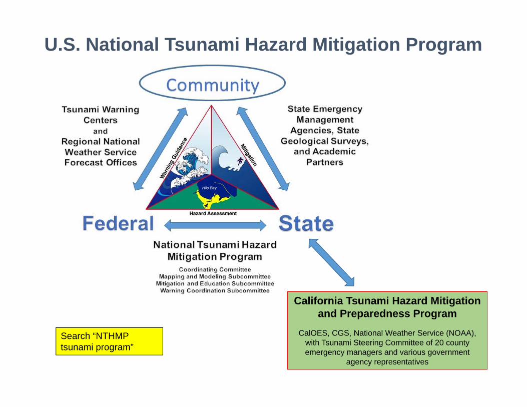
U.S. National Tsunami Hazard Mitigation Program
California Tsunami Hazard Mitigation and Preparedness Program
CalOES, CGS, National Weather Service (NOAA), with Tsunami Steering Committee of 20 county emergency managers and various government
agency representatives
Search “NTHMP tsunami program”

What is a tsunami?
wind wave
tsunami
Curling, breaking waves, water flows in for less than a minute
Very long surges, water flows in for tens of minutes

Other tsunami facts….• A tsunami always has many waves• This first wave is almost never the largest• The danger period can last 24 hours or more! (like the March 11, 2011 tsunami in California)
Third surge arriving at Ko Phi Thailand, December 26 2004

What causes a tsunami?
Submarine faults Submarine/Subaerial landslides

March 11, 2011 Tohoku-oki tsunamiLocation: Sendai Plain, Japan - Tsunami arrives one hour after M9.0
earthquake

Sendai PlainBefore tsunami
¼ mile

Sendai PlainAfter tsunami
¼ mile

Aneyoshi Bay (5 months
after tsunami)

Aneyoshi Bay (5 months
after tsunami)

Aneyoshi Bay (5 months
after tsunami)
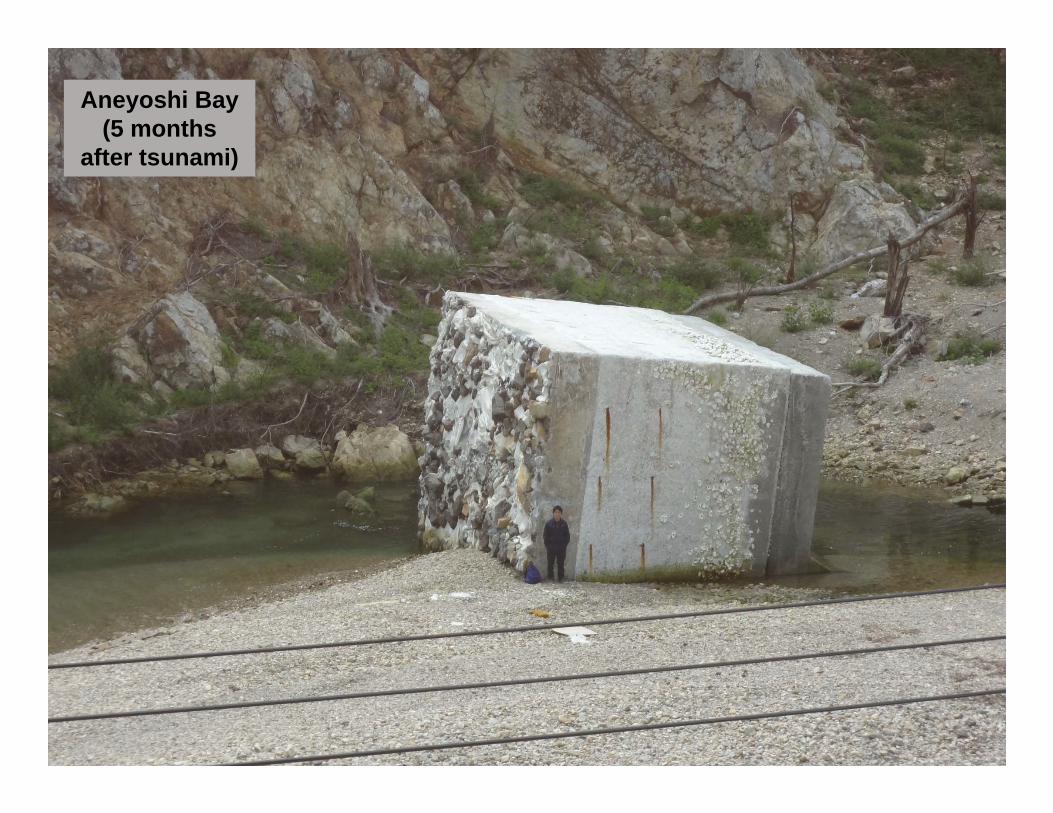
Aneyoshi Bay (5 months
after tsunami)

Aneyoshi Bay (5 months
after tsunami)
Search “EERI Wilson 2011 Tohoku tsunami”

California has its faults!
Ventura County

• Eight significant trans-Pacific tsunamis (1946, 1952, 1957, 1960, 1964, 2006, 2010, and 2011) over past 70 years.
• Each of these events caused damage in California, with 1946, 1960, and 1964 causing inundation.
• Local tsunami events are less common but the most significant one was 1700 Cascadia (no written US record).
Significant Historical Tsunamis in California
1946 – Half Moon Bay
1960 – Crescent City
1964 – Crescent CitySearch “CGS California tsunami history”

Notable Historical Tsunamis in Ventura County
‐ Local Source ‐Earthquake and tsunami
together
‐ Distant Source ‐Tsunamis without felt
earthquakes
Run‐up amplitude, in feet, above normal tide
conditions
OBS = observed tsunami activity
NR = No damage or severe conditions reported

Japan March ’11
WARNING/ADVISORY
Chile Feb ’10
ADVISORY
Samoa Sept ’09
ADVISORY
Chile Sept ’15
ADVISORY
British Columbia Oct ’12
ADVISORY
Recent California Tsunami Advisory-and Warning-level
Events
5 in Last 7 Years

• Large tidal fluctuations = 16 feet in Crescent City (largest surges at low tide)
• Strong currents/debris in harbors
• Potential dangerous tsunami conditions lasted for more than 24 hours.
• Impacts: one fatality; two dozen harbors damaged; Official = $50M; Total ~$100M
2011 Tohoku Tsunami in California
March 11, 2011 Tohoku Tsunami in California; video at 11AM (about 3 hours after first arrival of
tsunami) within Santa Cruz Harbor
Search “CGS 2011 tsunami in California”

Damage and Effects from
Recent Tsunamis in Ventura County
Active tsunami at mouth of Ventura Harbor during 2015 Chile
Area of damaged dock in Ventura Harbor after 2011 Japan
Damage in Ventura Harbor after 2010 Chile

Local Tsunami Source Scenarios for Ventura County (in feet above Mean Sea Level)
Historical
Fault Activity
Active
Potentially active to not active
Channel IslandsThrust Faults
Goleta Submarine Landslides 1 and 2
Anacapa-Dume Fault
Ventura-Pitas Pt Fault
Catalina Fault (to the south)
Santa Monica Fault (to the southeast)

Local-Source TsunamiEarthquake followed by tsunami
What should people do?
Natural “WARNING” signs
• FEEL … Strong earthquake shaking
• SEE … Water receding exposing sea floor
• HEAR … A loud ocean roar
If one or more of these natural warning signs occurs, go immediately to high ground or inland and stay there ….
You may only have minutes before a tsunami arrives.

Tsunami without felt earthquake Distant sources: Large earthquakes along Pacific “Ring of Fire”
Cascadia Example: Cascadia Subduction Zone

Distant Source Tsunami
Scenarios for Ventura County(in feet above Mean Sea
Level)

Tsunami Notification
Deep Ocean Assessment and Reporting of Tsunami (DART) Buoy
WR8

Slide 24
WR8 Important to make it clear that the "Tsunami Notifications" are only realiable for tsunamis coming from a distant source.Wilson, Rick@DOC, 3/13/2017

National Tsunami Warning Center(NTWC)

History of Tsunamis in California

Official NOAA/NWS Alert BulletinsTsunami WARNING (>3 feet)Widespread inundation is imminent or occurring Full Evacuation Suggested, Move to Higher Ground
Tsunami ADVISORY (1 foot to 3 feet)Strong currents are imminent or occurringMove Away From Shore, Harbors, Marinas
Tsunami WATCHPotential Tsunami - May Impact Your AreaStay Alert For More Info, May be upgraded to Warning/Advisory
Tsunami INFORMATIONMinor Waves at MostNo Action Suggested
http://wcatwc.arh.noaa.gov/Products/msgdefs.htm

Deep-ocean Assessment and Reporting of Tsunamis (DART®)

Initial State Response to: WARNING and/or ADVISORY
• PARTICIPATE in CALLS WITH NATIONAL TSUNAMI WARNING CENTER
• ACTIVATE STATE EOC’s (SOC / REOC)
• CONDUCT CALLS WITH EMERGENCY MANAGERS IN 20 COASTAL COUNTIES (EOC / DOC)
Tohoku2011

Specific areas/locations of heightened concern based on
• “Start of Tsunami” Times• Expected Wave Heights• Concurrent Tide Conditions
Current & projected status of WARNING / ADVISORY / WATCH
What will be in the next bulletin? When it will come out?
Any specific questions or clarifications from states and entities
Information exchanged during NTWC calls:

EXISTING: Evacuation Map & Plan
Inundation Map
Evacuation Map
County / City Evacuation Plan / ConOps1. “Evacuate Sector (1) South of
Main Street and West of First Street”
2. “Evacuate Sector (2) West of PCH between Newport Blvd. and 60thSt.”
3. Etc.

Distant‐Source TsunamiTsunami without felt earthquake
What should people do?Official Warning
You may be notified of a Tsunami Warning or Advisory has been issued by:
• TV or radio stations, internet• Door-to-door contact by emergency personnel• Reverse 911 call• NOAA weather radios• Outdoor sirens (could be police/fire)
If you receive an official warning, seek high ground and find out more information from the TV, radio, or internet.
Follow directions of emergency personnel.

Be Informed – Know if you are in tsunami zone and where safe areas are nearby
Be Prepared – Make a Family Plan
Listen to Instructions from Local Emergency Responders
Move Inland and/or to Higher Ground
Walk the Evacuation Route if Possible
Last Resort!!! If You Cannot Evacuate the Area, Go to the Third or Higher Floor of a Sturdy Building
If You Are Outside the Tsunami Hazard Zone – Take No Action/Stay There
What Should I Do To Prepare?
State tsunami inundation map for Ventura area

Thank you!
Email: [email protected]
Websites: http://www.quake.ca.gov
http://www.tsunami.ca.gov
http://myhazards.ca.gov
http://tsunamizone.org
To download inundation maps: www.tsunami.ca.gov
GoogleEarth file under “Download Spatial Data”
Tsunami Inundation Map
State tsunami evacuation map for Oxnard area