Embed Size (px)
Citation preview

Can
berr
a In
vest
men
t Cor
pora
tion
Goo
gong
Wat
er C
ycle
Pro
ject
Eco
logi
cal A
sses
smen
ts -
Terr
estr
ial F
lora
and
Fau
na
CN
211
2972
009-
001
140
Fina
l Tab
le A
19.
Res
ults
of
Veg
etat
ion
Tra
nse
cts
at G
oo
go
ng
Cre
ek
Cov
er/A
bund
ance
(for
eac
h sp
ecie
s fo
r bel
t tra
nsec
t): 1
= <
5%
cov
er; 2
= 6
-25%
cov
er; 3
= 2
6-50
% c
over
; 4 =
51-
75%
cov
er; 5
= 7
6-10
0% c
over
Fam
ily a
nd S
cien
tific
Nam
e
Com
mon
Nam
e
GC
1 G
C2
GC
3 G
C4
GC
5 G
C6
GC
7 G
C8
GC
9 G
C10
G
C11
G
C12
G
C13
G
C14
Non
-nat
ive
Gra
sses
Ave
na fa
tua
Wild
Oat
1
1
1
Bot
hrio
chlo
a m
acra
R
edle
g G
rass
1
1
1
Bro
mus
cat
harti
cus
Pra
irie
Gra
ss
1
1
1 1
Bro
mus
mol
lifor
mis
S
oft B
rom
e
1
1
Era
gros
tis b
row
nii
Love
Gra
ss
1 1
1
1
Era
gros
tis c
urvu
la
Afri
can
Love
Gra
ss
1
1
1
1 1
Impe
rata
cyl
indr
ica
Bla
dy G
rass
1 1
1
1
Loliu
m p
eren
ne
Per
enni
al R
yegr
ass
1
Nas
sella
tric
hoto
ma
Ser
rate
d Tu
ssoc
k
1 1
3 2
1 1
1 1
1 1
1 1
Pas
palu
m d
ilata
tum
C
ater
pilla
r Gra
ss
1
1
1
Pha
laris
aqu
atic
a P
hala
ris
1
1
Pha
laris
min
or
Pha
laris
1
1
Poa
ann
ua
Win
ter g
rass
1
1
Poa
sie
beria
na
Poa
tuss
ock/
Sno
wgr
ass
1
2 1
1 1
1 1
1 1
Nat
ive
Gra
sses
Aus
trost
ipa
scab
ra v
ar. f
alca
ta
Sle
nder
Spe
ar G
rass
1
1
1
1 1
1 1
1 1
1 1
1
Them
eda
aust
ralis
K
anga
roo
Gra
ss
1
Sedg
es
Junc
us a
rticu
latu
s R
ush
1 1
1
Junc
us u
sita
tus
C
omm
on R
ush
1
1
1
1 1
1 1
Typh
a or
ient
alis
C
umbu
ngi
1
1 1
Forb
s
Con
ium
mac
ulat
um
Hem
lock
1
1 1
1 1
1 1
1 1
1
Dau
cus
gloc
hidi
atus
N
ativ
e C
arro
t 1
1
1 1

Can
berr
a In
vest
men
t Cor
pora
tion
Goo
gong
Wat
er C
ycle
Pro
ject
Eco
logi
cal A
sses
smen
ts -
Terr
estr
ial F
lora
and
Fau
na
CN
211
2972
009-
001
141
Fina
l Tab
le A
19 (
cont
.).
Res
ults
of
Veg
etat
ion
Tra
nse
cts
at G
oo
gon
g C
reek
Fam
ily a
nd S
cien
tific
Nam
e
Com
mon
Nam
e
GC
1 G
C2
GC
3 G
C4
GC
5 G
C6
GC
7 G
C8
GC
9 G
C10
G
C11
G
C12
G
C13
G
C14
Foen
icul
um v
ulga
re
Fenn
el
1
1
1
Hyd
roco
tyle
laxi
flora
S
tinki
ng P
enny
wor
t 1
1 1
Asp
leni
um fl
abel
lifol
ium
N
eckl
ace
Fern
1
1 1
1
Pte
ridiu
m e
scul
entu
m
Com
mon
Bra
cken
1
1 1
1 1
1
Hib
berti
a rip
aria
G
uine
a Fl
ower
1
1
Chr
ysoc
epha
lum
api
cula
tum
Y
ello
w B
utto
ns
1 1
1 1
1 1
1 1
Cirs
ium
vul
gare
S
pear
Thi
stle
1
1 1
1 1
1 1
1 1
1 1
1 1
1
Con
yza
bona
riens
is
Flea
bane
1
1 1
1 1
1 1
1 1
1
Lact
uca
serio
la
Pric
kly
Lettu
ce
1
Cot
ula
aust
ralis
C
omm
on C
otul
a 1
1 1
1
1
Cot
ula
coro
nopi
folia
W
ater
But
tons
1 1
1 1
1
Con
volv
ulus
eru
besc
ens
Aus
tralia
n B
indw
eed
1 1
1
1
Cra
ssul
a he
lmsi
i S
wam
p C
rass
ula
1
1 1
1 1
1
Lact
uca
serr
iola
P
rickl
y Le
ttuce
1
Lept
orhy
ncho
s sq
uam
atus
S
caly
But
tons
1
1
Sen
ecio
qua
drid
enta
tus
C
otto
n Fi
re-w
eed
1
1
Son
chus
ole
race
us
Com
mon
Sow
this
tle
1
1 1
1 1
Tara
xacu
m o
ffici
nale
D
ande
lion
1
1 1
1
1
1
1 1
1
Vitt
adin
ia c
unea
ta
Fuzz
wee
d
1
1
1
Azo
lla fi
licul
oide
s A
zolla
1
1 1
1 1
Ble
chnu
m n
udum
Fi
shbo
ne W
ater
Fer
n 1
1
1 1
1
Ech
ium
pla
ntag
ineu
m
Pat
ters
on’s
Cur
se
1 1
1 1
1 1
1
1 1
Hirs
chfe
ldia
inca
na
Buc
han
Wee
d
1
Lepi
dium
afri
canu
m
Com
mon
Pep
perc
ress
1
1
Wah
lenb
ergi
a co
mm
unis
Tu
fted
Blu
ebel
l 1
1 1
1 1
1 1
1
1
1 1
1

Can
berr
a In
vest
men
t Cor
pora
tion
Goo
gong
Wat
er C
ycle
Pro
ject
Eco
logi
cal A
sses
smen
ts -
Terr
estr
ial F
lora
and
Fau
na
CN
211
2972
009-
001
142
Fina
l Tab
le A
19 (
cont
.).
Res
ults
of
Veg
etat
ion
Tra
nse
cts
at G
oo
gon
g C
reek
Fam
ily a
nd S
cien
tific
Nam
e
Com
mon
Nam
e
GC
1 G
C2
GC
3 G
C4
GC
5 G
C6
GC
7 G
C8
GC
9 G
C10
G
C11
G
C12
G
C13
G
C14
Wah
lenb
ergi
a st
ricta
Ta
ll B
lueb
ell
1 1
1 1
1
1
1
Hyp
erci
um p
erfo
ratu
m
St J
ohn’
s W
ort
1 1
1
1
1
1 1
Pet
rorh
agia
nat
euill
i
1
1 1
Pul
tena
ea p
rocu
mbe
ns
Egg
and
Bac
on
1
1
Des
mod
ium
unc
inat
um
Silv
er-le
af D
esm
odiu
m
1 1
Trifo
lium
arv
ense
H
orse
foot
Clo
ver
1
Trifo
lium
cam
pest
re
Hop
Clo
ver
1 1
1 1
1 1
Trifo
lium
tom
ento
sum
W
oolly
Clo
ver
1 1
1
Ger
aniu
m m
olle
ssp
. mol
le
Cra
nesb
ill G
eran
ium
1 1
Dia
nella
revo
luta
Fl
ax L
ily
1
1
1
1 1
1
1
Tric
hory
ne e
latio
r Y
ello
w R
ush
Lily
1 1
Lom
andr
a fil
iform
is s
sp. f
ilifo
rmis
W
attle
Mat
rush
1
1
Am
yem
a sp
p.
1 1
1 1
1 1
1
1
Pla
ntag
o la
nceo
lata
La
mb’
s To
ngue
1 1
1 1
1
1
Pla
ntag
o m
ajor
P
lant
ain
1
1
Ace
tose
lla v
ulga
ris
She
ep S
orre
l
1
1 1
1 1
1 1
1 1
1
Pol
ygon
um a
rena
stru
m
Wire
wee
d 1
1
1
1 1
1 1
1 1
1
Per
sica
ria p
rost
rata
P
rost
rate
Kno
twee
d
1
1 1
1 1
Rum
ex b
row
nii
Sw
amp
Doc
k 1
1 1
1 1
1 1
1 1
1 1
1
Sal
via
verb
enac
a W
ild S
age
1
1 1
Mar
rubi
um v
ulga
re
Hor
ehou
nd
1 1
San
guis
orba
min
or s
sp. m
uric
ata
She
ep’s
Bur
net
1
1 1
Ver
basc
um th
apsu
s G
reat
Mul
lein
1 1
1 1
1 1
1 1
1 1
1 1
1
Ver
basc
um v
irgat
um
Twig
gy M
ulle
in
1 1
1 1
1
1
1 1
Ver
onic
a an
agal
lis-a
quat
ica
1 1
1 1
1 1
Ver
bena
bon
arie
nsis
P
urpl
etop
1
1 1
1 1
1
1
1

Can
berr
a In
vest
men
t Cor
pora
tion
Goo
gong
Wat
er C
ycle
Pro
ject
Eco
logi
cal A
sses
smen
ts -
Terr
estr
ial F
lora
and
Fau
na
CN
211
2972
009-
001
143
Fina
l Tab
le A
19 (
cont
.).
Res
ults
of
Veg
etat
ion
Tra
nse
cts
at G
oo
gon
g C
reek
Fam
ily a
nd S
cien
tific
Nam
e
Com
mon
Nam
e
GC
1 G
C2
GC
3 G
C4
GC
5 G
C6
GC
7 G
C8
GC
9 G
C10
G
C11
G
C12
G
C13
G
C14
Vio
la b
eton
icifo
lia
Sho
wy
Vio
let
1
1 1
Tree
s/S
hrub
s
Aca
cia
decu
rren
s
Bla
ck W
attle
1
1
1
1
1 1
1 1
Aca
cia
mea
rnsi
i G
reen
Wat
tle
1 1
1
1 1
1 2
2 2
2 2
2
Aca
cia
pycn
anth
a G
olde
n W
attle
1
1 1
1 1
1 1
1 1
1 1
2 2
Aca
cia
prav
issi
ma
Wed
ged-
leaf
Wat
tle
1
1
1 1
1
1 1
Bur
saria
spi
nosa
1
1 1
1
Cal
liste
mon
sie
beri
R
iver
Bot
tlebr
ush
1 1
Euc
alyp
tus
blak
elyi
B
lake
ly’s
Red
Gum
1
1 1
Euc
alyp
tus
dive
s
Bro
ad-le
aved
Pep
perm
int
1
1 1
1
Euc
alyp
tus
mac
rorh
ynch
a R
ed S
tring
ybar
k
1 1
Euc
alyp
tus
man
nife
ra
Brit
tle G
um
1 1
1 1
1
Euc
alyp
tus
mel
liodo
ra
Yel
low
Box
1
1 1
1 1
1 1
1 1
1 2
2 1
1
Euc
alyp
tus
norto
nii
Mea
ly B
undy
1
1
1
Euc
alyp
tus
poly
anth
emos
R
ed B
ox
1
1
1 1
1
1
2 2
1
Euc
alyp
tus
ross
i S
crib
bly
Gum
1 1
1 1
1
1 1
Lam
berti
a fo
rmos
a M
ount
ain
Dev
il
1 1
1
Lyci
um fe
rroc
issi
mum
A
frica
n B
oxth
orn
1 1
1 1
1 1
1
Kun
zea
eric
oide
s B
urga
n 2
3 4
4 2
2 3
4 2
2 3
3
Lept
ospe
rmum
con
tinen
tale
Te
e Tr
ee
1
Lept
ospe
rmum
obo
vatu
m
Tea
Tree
1
Pom
ader
ris a
ndro
med
ifolia
1
1 1
1
Pom
ader
ris a
ngus
tifol
ia
1 1
1
Ros
a ru
bigi
nosa
S
wee
t Bria
r
1
1
1 1
2 2
2
Rub
us fr
uitic
osus
B
lack
berr
y
2
2 3
2 2
2 2
2 2
3 3

Can
berr
a In
vest
men
t Cor
pora
tion
Goo
gong
Wat
er C
ycle
Pro
ject
Eco
logi
cal A
sses
smen
ts -
Terr
estr
ial F
lora
and
Fau
na
CN
211
2972
009-
001
144
Fina
l
D
isch
arge
loca
tion
of C
reek
at
Que
anbe
yan
Riv
er; T
rans
ect G
C1
C
reek
hab
itat,
look
ing
north
-eas
t at
Tran
sect
GC
2
C
reek
hab
itat,
look
ing
north
at T
rans
ect 1
Clu
ster
s of
tree
s al
ong
Old
Coo
ma
Roa
d,
adja
cent
to T
rans
ects
2-3
W
oodl
and
on e
ast s
ide,
Tra
nsec
t GC
8
Dam
3, u
pstre
am o
f Tra
nsec
t GC
6
View
of f
ire tr
ails
thro
ugh
Woo
dlan
d
Dam
1, u
pstre
am o
f Tra
nsec
t GC
5
A
view
of w
oodl
and
habi
tat l
ooki
ng n
orth
ad
jace
nt to
Tra
nsec
t GC
9
O
pen
Cre
ek h
abita
t loo
king
nor
th-e
ast
adja
cent
to T
rans
ect G
C10
C
reek
thro
ugh
blac
kber
ry-in
fest
ed g
ullie
s,
adja
cent
to T
rans
ect G
C11
Pr
omin
ent e
rosi
on in
the
uppe
r sec
tions
of
the
Cre
ek, n
ear T
rans
ect G
C12
Pla
te 2
4.
Ph
oto
gra
ph
s sh
ow
ing
veg
etat
ion
an
d h
abit
at a
lon
g G
oo
go
ng
Cre
ek

Can
berr
a In
vest
men
t Cor
pora
tion
Goo
gong
Wat
er C
ycle
Pro
ject
Eco
logi
cal A
sses
smen
ts -
Terr
estr
ial F
lora
and
Fau
na
CN
211
2972
009-
001
145
Fina
l
M
iddl
e se
ctio
n of
the
Goo
gong
Cre
ek a
t Tr
anse
ct G
C10
To
p en
d of
the
Goo
gong
Cre
ek, l
ooki
ng
sout
h fro
m T
rans
ect G
C14
Vi
ew o
f Goo
gong
Crre
k ha
bita
t at t
he to
p en
d- lo
okin
g no
rth to
war
ds th
e Fa
rm D
am
Bl
ackb
erry
(Rub
us fr
uitic
osus
) inf
esta
tions
in
the
Cre
ek; N
ote
Woo
dlan
ds in
the
back
grou
nd
Bu
rgan
(Kun
zea
eric
oide
s) in
fest
atio
ns
Br
acke
n (P
terid
ium
esc
ulen
tum
) in
fest
atio
ns
Se
rrate
d Tu
ssoc
k (N
asel
la tr
icho
tom
a)
infe
sts
mid
dle
sect
ions
of t
he C
reek
Sa
lvia
ver
bena
ca in
fest
atio
n at
top
end
of
Cre
ek
Pla
te 2
4 (c
on
t.).
Ph
oto
gra
ph
s sh
ow
ing
veg
etat
ion
an
d h
abit
at a
lon
g G
oo
go
ng
Cre
ek

Canberra Investment Corporation Googong Water Cycle Project Ecological Assessments - Terrestrial Flora and Fauna
CN 2112972009-001 146 Final
Appendix 11 - Fauna Lists
Can
berr
a In
vest
men
t Cor
pora
tion
Goo
gong
Wat
er C
ycle
Pro
ject
Eco
logi
cal A
sses
smen
ts -
Terr
estr
ial F
lora
and
Fau
na
CN
211
2972
009-
001
147
Fina
l
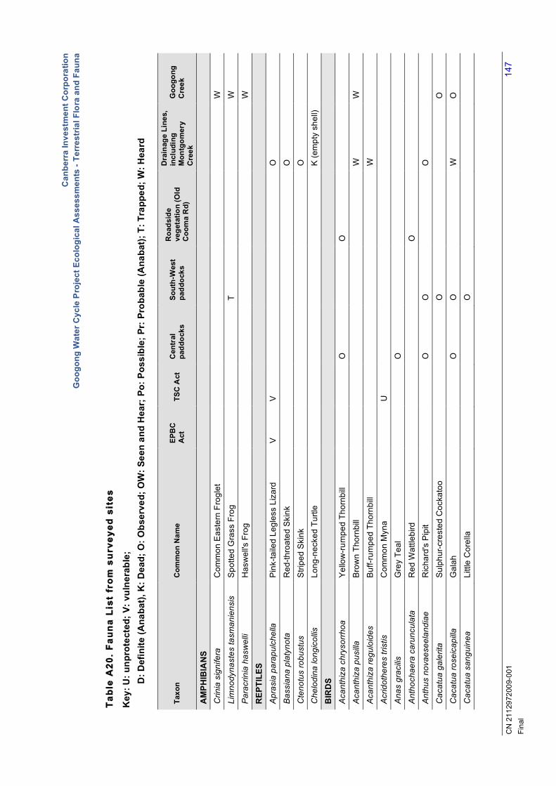
Tab
le A
20.
Fau
na
List
fro
m s
urv
eyed
sit
es
Key
: U: u
npro
tect
ed; V
: vul
nera
ble;
D: D
efin
ite (A
naba
t), K
: Dea
d; O
: Obs
erve
d; O
W: S
een
and
Hea
r; P
o: P
ossi
ble;
Pr:
Pro
babl
e (A
naba
t); T
: Tra
pped
; W: H
eard
Taxo
n C
omm
on N
ame
EPB
C
Act
TS
C A
ct
Cen
tral
pa
ddoc
ks
Sout
h-W
est
padd
ocks
Roa
dsid
e ve
geta
tion
(Old
C
oom
a R
d)
Dra
inag
e Li
nes,
in
clud
ing
Mon
tgom
ery
Cre
ek
Goo
gong
C
reek
AM
PHIB
IAN
S
C
rinia
sig
nife
ra
Com
mon
Eas
tern
Fro
glet
W
Lim
nody
nast
es ta
sman
iens
is
Spo
tted
Gra
ss F
rog
T
W
Par
acrin
ia h
asw
elli
Has
wel
l's F
rog
W
REP
TILE
S
Apr
asia
par
apul
chel
la
Pin
k-ta
iled
Legl
ess
Liza
rd
V
V
O
Bas
sian
a pl
atyn
ota
Red
-thro
ated
Ski
nk
O
Cte
notu
s ro
bust
us
Stri
ped
Ski
nk
O
Che
lodi
na lo
ngic
ollis
Lo
ng-n
ecke
d Tu
rtle
K
(em
pty
shel
l)
BIR
DS
Aca
nthi
za c
hrys
orrh
oa
Yel
low
-rum
ped
Thor
nbill
O
O
Aca
nthi
za p
usilla
B
row
n Th
ornb
ill
W
W
Aca
nthi
za re
gulo
ides
B
uff-r
umpe
d Th
ornb
ill
W
Acr
idot
here
s tri
stis
C
omm
on M
yna
U
Ana
s gr
acilis
G
rey
Teal
O
Ant
hoch
aera
car
uncu
lata
R
ed W
attle
bird
O
A
nthu
s no
vaes
eela
ndia
e R
icha
rd's
Pip
it
O
O
O
Cac
atua
gal
erita
S
ulph
ur-c
rest
ed C
ocka
too
O
O
Cac
atua
rose
icap
illa
Gal
ah
O
O
W
O
Cac
atua
san
guin
ea
Littl
e C
orel
la
O

Can
berr
a In
vest
men
t Cor
pora
tion
Goo
gong
Wat
er C
ycle
Pro
ject
Eco
logi
cal A
sses
smen
ts -
Terr
estr
ial F
lora
and
Fau
na
CN
211
2972
009-
001
148
Fina
l
Tab
le A
20 (
cont
.).
Fau
na
List
fro
m s
urv
eyed
sit
es
Taxo
n C
omm
on N
ame
EPB
C
Act
TS
C A
ct
Cen
tral
pa
ddoc
ks
Sout
h-W
est
padd
ocks
R
oads
ide
vege
tatio
n (O
ld
Coo
ma
Rd)
Dra
inag
e Li
nes,
in
clud
ing
Mon
tgom
ery
Cre
ek
Goo
gong
C
reek
Cac
oman
tis fl
abel
lifor
mis
Fa
n-ta
iled
Cuc
koo
W
Che
none
tta ju
bata
A
ustra
lian
Woo
d D
uck
O
O
Chr
ysoc
occy
x lu
cidu
s S
hini
ng B
ronz
e-C
ucko
o
W
C
orac
ina
nova
ehol
land
iae
Bla
ck-fa
ced
Cuc
koo-
shrik
e
O
Cor
cora
x m
elan
orha
mph
os
Whi
te-w
inge
d C
houg
h
W
Cor
vus
coro
noid
es
Aus
tralia
n R
aven
O
O
Cor
vus
mel
lori
Littl
e R
aven
Cra
ctic
us n
igro
gula
ris
Pie
d B
utch
erbi
rd
Cuc
ulus
pal
lidus
P
allid
Cuc
koo
W
Dac
elo
nova
egui
neae
La
ughi
ng K
ooka
burra
W
Eop
saltr
ia a
ustra
lis
Eas
tern
Yel
low
Rob
in
OW
E
urys
tom
us o
rient
alis
D
olla
rbird
Falc
o ce
nchr
oide
s N
anke
en K
estre
l
O
O
Ger
ygon
e ol
ivac
ea
Whi
te-th
roat
ed G
eryg
one
W
W
Gra
llina
cyan
oleu
ca
Mag
pie-
lark
O
O
Gym
norh
ina
tibic
en
Aus
tralia
n M
agpi
e
O
O
O
Gym
norh
ina
tibic
en
Aus
tralia
n M
agpi
e
O
Hiru
ndo
arie
l Fa
iry M
artin
Lich
enos
tom
us c
hrys
ops
Yel
low
-face
d H
oney
eate
r
W
Li
chen
osto
mus
leuc
otis
W
hite
-ear
ed H
oney
eate
r
O
Mal
urus
cya
neus
S
uper
b Fa
iry-w
ren
O
W
OW
Man
orin
a m
elan
ocep
hla
Noi
sy M
iner

Can
berr
a In
vest
men
t Cor
pora
tion
Goo
gong
Wat
er C
ycle
Pro
ject
Eco
logi
cal A
sses
smen
ts -
Terr
estr
ial F
lora
and
Fau
na
CN
211
2972
009-
001
149
Fina
l
Tab
le A
20 (
cont
.).
Fau
na
List
fro
m s
urv
eyed
sit
es
Taxo
n C
omm
on N
ame
EPB
C
Act
TS
C A
ct
Cen
tral
pa
ddoc
ks
Sout
h-W
est
padd
ocks
R
oads
ide
vege
tatio
n (O
ld
Coo
ma
Rd)
Dra
inag
e Li
nes,
in
clud
ing
Mon
tgom
ery
Cre
ek
Goo
gong
C
reek
Neo
chm
ia te
mpo
ralis
R
ed-b
row
ed F
inch
W
Ocy
phap
s lo
phot
es
Cre
sted
Pig
eon
O
Pac
hyce
phal
a ru
fiven
tris
Ruf
ous
Whi
stle
r
W
W
Par
dalo
tus
stria
tus
Stri
ated
Par
dalo
te
W
W
Pas
ser d
omes
ticus
H
ouse
Spa
rrow
U
OW
O
Pet
roic
a ro
sea
Ros
e R
obin
W
Pla
tyce
rcus
ele
gans
C
rimso
n R
osel
la
O
O
O
O
Pla
tyce
rcus
exi
miu
s E
aste
rn R
osel
la
O
O
O
W
Pse
phot
us h
aem
aton
otus
R
ed-ru
mpe
d P
arro
t
O
O
Rhi
pidu
ra a
lbis
capa
G
rey
Fant
ail
O
W
O
Rhi
pidu
ra le
ucop
hrys
W
illie
Wag
tail
OW
S
eric
orni
s fro
ntal
is
Whi
te-b
row
ed S
crub
wre
n
O
Stre
pera
gra
culin
a P
ied
Cur
raw
ong
O
W
Stu
rnus
vul
garis
C
omm
on S
tarli
ng
U
O
Zost
erop
s la
tera
lis
Silv
erey
e
W
OW
MA
MM
ALS
Cha
linol
obus
gou
ldii
Gou
ld's
Wat
tled
Bat
D
D
D
D
Cha
linol
obus
mor
io
Cho
cola
te W
attle
d B
at
Pr
Pr
D
Mac
ropu
s gi
gant
eus
Eas
tern
Gre
y K
anga
roo
M
inio
pter
us s
chre
iber
sii
ocea
nens
is
Eas
tern
Ben
twin
g B
at
Pr
P
o
Mor
mop
teru
s sp
. un
iden
tifie
d Fr
eeta
il B
at
P
o
P
o

Can
berr
a In
vest
men
t Cor
pora
tion
Goo
gong
Wat
er C
ycle
Pro
ject
Eco
logi
cal A
sses
smen
ts -
Terr
estr
ial F
lora
and
Fau
na
CN
211
2972
009-
001
150
Fina
l
Tab
le A
20 (
cont
.).
Fau
na
List
fro
m s
urv
eyed
sit
es
Taxo
n C
omm
on N
ame
EPB
C
Act
TS
C A
ct
Cen
tral
pa
ddoc
ks
Sout
h-W
est
padd
ocks
R
oads
ide
vege
tatio
n (O
ld
Coo
ma
Rd)
Dra
inag
e Li
nes,
in
clud
ing
Mon
tgom
ery
Cre
ek
Goo
gong
C
reek
Mor
mop
teru
s sp
. 2
Free
tail
Bat
P
o
Mor
mop
teru
s sp
. 4
Free
tail
Bat
D
Nyc
toph
ilus
sp.
Uni
dent
ified
Lon
g-ea
red
Bat
D
D
P
r Ta
darid
a au
stra
lis
Whi
te-s
tripe
d Fr
eeta
il B
at
D
D
D
D
Vep
sade
lus
darli
ngto
ni
Larg
e Fo
rest
Bat
P
r P
r
P
r
Ves
pade
lus
regu
lus
Sou
ther
n Fo
rest
Bat
P
o
Po
Ves
pade
lus
vultu
rnus
Li
ttle
Fore
st B
at
D
D
D
Lepu
s eu
ropa
eus
Bro
wn
Har
e
U
O
Ory
ctol
agus
cun
icul
us
Eur
opea
n R
abbi
t
U
O
Vul
pes
vulp
es
Fox
U
O

Canberra Investment Corporation Googong Water Cycle Project Ecological Assessments - Terrestrial Flora and Fauna
CN 2112972009-001 151 Final
Appendix 12 - Part 3A Impact Assessments - Flora

Canberra Investment Corporation Googong Water Cycle Project Ecological Assessments - Terrestrial Flora and Fauna
CN 2112972009-001 152 Final
Flora As discussed in the report, no threatened species or populations were found in the flora surveys at the subject sites. However, the habitat assessment, combined with flora survey information and data obtained by the literature reviews, collectively indicate the existence of ‘habitat’ that might be considered suitable for one EEC and seven Threatened Species, listed by the TSC Act. In this Section, ‘Tests of Significance’ are conducted based on the Threatened Species Assessment Guidelines (DEC, DPI, 2005) for those, listed below. The potential impacts on the EEC, individual species and their habitat are assessed against criteria outlined in Appendix 3 of the Draft Guidelines (DEC, DPI, 2005)
Endangered Ecological Communities:
o White Box-Yellow Box-Blakely's Red Gum Grassy Woodland and Derived Native Grassland’
Threatened Species:
o Button Wrinklewort (Rutidosis leptorrhynchoides); o Mountain Swainson Pea (Swainsona recta); o Tessellated Spider Orchid (Caladenia tessellata); o Silky Swainson Pea (Swainsona sericea); o Pale Pomaderris (Pomaderris pallida); o Mauve Burr-daisy (Calotis glandulosa); and o Austral Toadflax (Thesium australe).

Canberra Investment Corporation Googong Water Cycle Project Ecological Assessments - Terrestrial Flora and Fauna
CN 2112972009-001 153 Final
Endangered Ecological Communities
White Box-Yellow Box-Blakely’s Red Gum Grassy Woodland and Derived Native Grassland
The ‘White Box-Yellow Box-Blakely's Red Gum Grassy Woodland and Derived Native Grassland’ ecological community is found on relatively fertile soils on the tablelands and western slopes of NSW. It is listed in the NSW TSC Act as endangered. The EPBC Act lists the EEC as critically endangered. The EEC, formerly known in NSW as ‘White Box-Yellow Box-Blakely’s Red Gum Woodland’, is now referred to by the new name, which recognises the significance of the understorey grassy vegetation. Its informal name is ‘Box-Gum Grassy Woodland and Derived Grassland’ (DEWHA, 2006a; b). The EEC occurs in areas of NSW that receive rainfall between the 400 and 800 mm per annum, extending from the western slopes, at an altitude of about 170 m to about 1200 m, on the northern tablelands. Major regions where the EEC occurs within NSW include the North Coast, New England Tableland, Nandewar, Brigalow Belt South, Sydney Basin, South Eastern Highlands and NSW South Western Slopes Bioregions (NSW Scientific Committee, 2002a; DECC, 2009b; DEH, 2006b; c; DEWHA 2006a; b). The White Box-Yellow Box-Blakely’s Red Gum Grassy Woodlands that existed prior to European settlement now exists as remnants in three different states. The three states are: o An overstorey of eucalypt trees exists, but there is no substantial native understorey; o A native understorey exists, but the trees have been cleared. o Both a native understorey and an overstorey of eucalypts exist together.
In the nomination for listing the EEC, the Scientific Committee (DEWHA, 2006a) considered that areas in which an overstorey exists without a substantially native understorey are degraded and are no longer a viable part of the ecological community. Although some native species may remain, in most of these areas the native understorey is effectively irretrievable. In order for an area to be included in the listed ecological community, a patch must have a predominantly native understorey. The EEC includes those woodlands where the characteristic tree species are one or more of the following species in varying proportions and combinations - Eucalyptus albens (White Box), Eucalyptus melliodora (Yellow Box) or Eucalyptus blakelyi (Blakely's Red Gum). Native grass and herbaceous species generally characterise the ground layer. In some areas of the EEC, dominant pasture species typically change from Themeda australis, Austrostipa spp. and Poa spp. to Austrostipa falcata, Austrodanthonia spp. and Bothriochloa macra, as grazing intensity increases. This may reflect differences in palatability of these species and their ability to tolerate grazing pressure. Light grazing and burning may also lead to Aristida ramosa dominance (NSW Scientific Committee, 2002a). Shrubs are generally sparse or absent in the typical EEC, although they may be locally common in different areas. Woodlands with Eucalyptus albens are most common on the undulating country of the slopes region, while E. blakelyi and E. melliodora predominate in grassy woodlands on the tablelands. Drier woodland areas, dominated by E. albens, often form mosaics with areas dominated by E. blakelyi and E. melliodora, occurring in more moist situations, while areas subject to waterlogging may be treeless. Other Eucalypts are often found in association with E. melliodora and E. albens. Prober and Thiele (1995) discussed latitudinal and climatic gradients in the patterns of abundant species and the gradual change in herb and grass species occurring in the EEC, from northern to southern NSW. For instance, within the Box-Gum Woodland species, such as Rostellularia adscendens, Chloris ventricosa, Austrodanthonia racemosa, Brunoniella australis, Cymbopogon refractus, Swainsona galegifolia, Notelaea microcarpa, Stackhousia viminea, Olearia elliptica, Jasminum suavissimum, Plantago gaudichaudii, Dichanthium sericeum, Plantago debilis and Wahlenbergia communis are generally restricted to more northern areas (Prober and Thiele, 1995). On the other hand, in the southern areas, the common understorey species include: Gonocarpus elatus, Austrostipa blackii, Aristida behriana, Bracteantha viscosa, Austrodanthonia auriculata and Austrostipa nodosa (Prober and Thiele, 1996). The understorey may be highly modified by grazing history and disturbance. A number of native species appear not to tolerate grazing by domestic stock and are confined to the least disturbed remnants. These include species like Dianella revoluta, Diuris dendrobioides, Microseris lanceolata, Pimelea curviflora and Templetonia stenophylla (Prober and Thiele, 1995).

Canberra Investment Corporation Googong Water Cycle Project Ecological Assessments - Terrestrial Flora and Fauna
CN 2112972009-001 154 Final
A large number of fauna species of conservation significance are associated with Box-Gum Woodlands, as are a number of plants of conservation significance (NSW Scientific Committee, 2002a). The EEC is acknowledged as habitat for several flora species, which are listed as threatened species by the EPBC Act (viz. Button Wrinklewort - Rutidosis leptorrhynchoides; Mountain Swainson Pea - Swainsona recta; Mauve Burr Daisy - Calotis glandulosa; Hoary Sunray - Leucochrysum albicans var. tricolor; and Austral Toadflax - Thesium australe). The extent of the Box-Gum Woodlands has been drastically reduced in area and has become highly fragmented, because of human disturbances, including clearance for cropping and pasture improvement. Further, remnants of the community are degraded as a consequence of their disturbance history. Some remnants of these communities survive with the trees partly or wholly removed by post European activities, and conversely, often remnants of these communities survive with these tree species largely intact, but with the shrub or ground layers degraded to varying degrees through grazing or pasture modification NSW Scientific Committee, 2002a; ACT Government, 2004a; b; DECC, 2009b; DEH, 2006b; c; DEWHA 2006a; b. Other threats include: further clearing for cropping, pasture improvement or other development; and deterioration of the remnant condition caused by firewood cutting, increased livestock grazing, and invasion of remnants by non-native plant species. Non-native plant species that can lead to invasion of remnants include pasture species, as well as noxious weeds and environmental weeds. Environmental weeds include garden escapes, olives and pines. Degradation of the Box-Gum Woodlands’ landscape has also occurred due to inappropriate fire regimes, soil disturbance and increased nutrient loads, as well as soil acidification, salinity, and loss of connectivity between remnants. Furthermore, invasion of remnants and predation by feral animals (i.e. European Red Fox - Vulpes vulpes and the Feral Cat - Felis catus) is a Key Threatening Process under the EPBC Act that has been recognised as another cause of loss of fauna or modification of habitat in this EEC.
How is the proposal likely to affect the lifecycle of a threatened species and/or population?
This section is not applicable as ‘White Box-Yellow Box-Blakely's Red Gum Grassy Woodland and Derived Native Grassland’’ is listed as an EEC and not as a threatened species or population.
How is the proposal likely to affect the habitat of a threatened species, population or ecological community?
In order for an area to be included as containing the ‘White Box-Yellow Box-Blakely's Red Gum Grassy Woodland and Derived Grassland’ EEC, a patch must have a predominantly native understorey. This definition excludes much of the area affected by the proposal (i.e. Old Cooma Road, Googong Dam Road, WTP site and road corridor and Neighbourhood 1A from being considered further for the EEC, as these areas can no longer be identified as having a largely native understorey. However, despite the fragmentation that has been caused by past human activities, potential habitat for the EEC does exist in the Googong Creek habitat, affected by this proposal. This proposal envisages using the Googong Creek for discharges of stormwater from the residential development. Impacts of this activity need to be considered for the EEC, because the creek flows through an area containing the species assemblage of the EEC that has been fragmented by past human activities. However, most of the constituent species assemblages of the EEC occupy the upper riparian (typically 2-5 m above the creek) to terrestrial habitat, well above the creek. However, the amount of stormwater likely to be released is not high, as a result of water sensitive urban design (WSUD) elements to be implemented in the development. Also, the stormwater is not likely to be very high or enriched with nutrients, as the proposal involves stormwater treatment through WSUD elements. Following WSUD, the quality of the stormwater after development is not likely to be different from the existing runoff quality. Therefore, the Googong Creek habitat is not likely to be modified in a manner that poses a threat to habitat availability for the EEC. It is also not likely to modify conditions in the creek, so as to place at risk of extinction any species that characterise the EEC. The Box-Gum Woodland and Derived Grassland EEC is generally under threat because of indiscriminate clearing, degradation and fragmentation of remnants for agricultural, forestry, infrastructure and residential development and upgrades. Continuous heavy grazing and trampling of remnants by grazing stock has resulted in losses of plant species, thereby simplifying the understorey and ground layer and suppressing the development of a robust overstorey of canopy trees. Erosion and other soil changes, including increased nutrient status, as a result of clearing and development, continue to pose considerable threats.

Canberra Investment Corporation Googong Water Cycle Project Ecological Assessments - Terrestrial Flora and Fauna
CN 2112972009-001 155 Final
Whilst it must be recognised that development in the vicinity, as proposed, is likely to contribute to exacerbation of some of the above threats, the area of Box-Gum Woodlands associated with the Googong Creek are already heavily fragmented and continually impacted upon by fire trails and access roads that are supporting the adjacent Googong WTP. The creek is meandering through a fairly steep gully; its upper riparian to terrestrial vegetation is largely a mix of Box-Gum Woodlands’ species and vast shrubland areas dominated by Burgan (Kunzea ericoides) and a mix of Acacia spp. There are very little grasslands associated with the area, and even the available grasslands are severely infested with Serrated Tussock (Nassella trichotoma). Given the above, the proposed activity in the area, i.e. release of stormwater from the subdivision, will not significantly modify or reduce the extent of the EEC or its potential habitat, such that the extent or composition of the Box-Gum Woodlands in the area would be adversely affected.
Does the proposal affect any threatened species that are at the limit of its known distribution?
This section is not applicable as ‘White Box-Yellow Box-Blakely's Red Gum Grassy Woodland and Derived Native Grassland’’ is listed as an EEC and not as a threatened species or population.
How is the proposal likely to affect the current disturbance regimes?
The condition of Box-Gum Woodland and Derived Grassland remnants is well recognised to range from relatively good to highly degraded, such as paddock remnants with weedy understoreys and only a few hardy natives left. Some remnants of the community may consist of only an intact overstorey or an intact understorey, but may still have high conservation value due to the flora and fauna they support. Also, disturbed remnants are still considered to form part of the EEC, including remnants where the vegetation, either understorey, overstorey or both, would, under appropriate management, respond to assisted natural regeneration, such as where the natural soil and associated seed bank are still at least partially intact. Disturbed sites may be important flora and faunal habitat, have significant occurrences of particular species, form part of corridors or have the potential for recovery. The conservation value of remnants may be independent of remnant size. The Googong Creek habitat is already a highly modified environment, because of past and current land use practices. The area is disturbed, albeit infrequently, by the maintenance of access ways and fire trials associated with the Googong WTP. The discharge of stormwater down Googong Creek is not likely to introduce invasive species that could threaten or be harmful to the terrestrial EEC. The proposed works of discharging stormwater down Googong Creek is not likely to cause further perturbations or fragmentation of the habitat in the upper riparian slopes (occupied by the species assemblage of the EEC), so as to isolate areas that might be available for the species assemblage characteristic of the EEC, or for the broader EEC itself. After implementation of the WSUD elements in the new development, the quality of the stormwater from the proposal is not likely to be that different to drainage and runoff from a typical catchment with pastoral agricultural history as in the Googong area. Therefore, the stormwater is not likely to mobilize or introduce fertilizers, herbicides and/or other chemicals that would inhibit or harm the growth of species’ assemblage, which occupies the terrestrial habitat.
How is the proposal likely to affect habitat connectivity?
The amount of excess stormwater to be discharged after implementation of water sensitive urban design (WSUD) elements within the New Township is not expected to be much. The Googong Creek currently does not flow for much of the year. However, discharges will be more frequent than current after development, and this will alter the surface water drainage patters of the creek to some extent. Soil conditions in the creek may also be modified, as more water flows through the creek. Nevertheless, these changes in the conditions of the creek are not likely to be significant to the potential habitat of Box-Gum Woodlands and Derived Grasslands, essentially a terrestrial EEC. The stormwater to be discharged is not likely to be enriched with nutrients, as the proposal involves stormwater treatment through WSUD elements within the Googong development. Therefore, the abiotic conditions of the Googong Creek habitat are not likely to be modified, so as to pose a threat to habitat availability for the Box-Gum Woodlands and Derived Grasslands EEC or its characteristic species, which typically occupy the upper riparian slopes above the creek, extending to the terrestrial environments. Therefore, the proposed discharges are not likely to lead to a reduction in habitat, decrease habitat connectivity or cause other environmental modifications that would disrupt or compromise the viability of the EEC or its characteristic species present in the area to any extent.

Canberra Investment Corporation Googong Water Cycle Project Ecological Assessments - Terrestrial Flora and Fauna
CN 2112972009-001 156 Final
A draft recovery plan for the Box-Gum Woodland and Derived Grassland EEC has been prepared and is under review at present before release for public comment (DEWHA, 2006a). The priority recovery and threat abatement actions required for the EEC, which are relevant to this proposal, include the following: o Protecting all sites from further clearing and soil disturbance in and around remnants, such as ripping
planting lines and road grading; o Protection of remnants from weeds, by the speedy eradication of any new invasion; taking care to
spray or dig out only target species; o Avoiding the use of fertilizers in or near remnants; o In very small derived grassland sites, avoiding planting trees, as they may reduce the floral diversity
through competition for light, nutrients and water; o Focusing rehabilitation and planting on the edges of patches, expanding them, rather than within the
existing patches, gradually expanding to connect the existing remnants; o Undertaking control of rabbits, hares, foxes, pigs and goats (using methods that do not disturb the
native plants and animals of the remnant); o Not harvesting firewood from remnants (this includes living or standing dead trees and fallen
material); leaving fallen timber on the ground; o Encouraging regeneration by fencing remnants, controlling stock grazing and undertaking
supplementary planting, if necessary; o Erecting on-site markers to alert maintenance staff to the presence of a high quality remnant or
populations of a threatened species; and o Ensuring that remnants are connected to each other; in cases where remnants are not connected,
revegetating sites to link them, providing linkages for fauna and flora (pollen and seed dispersal).
Construction work associated with the Googong Creek in the proposal in relation to the proposed discharge of stormwater will be undertaken following the guidance of the Recovery Plan and ‘best practices’, so that adaptive management can be followed. This would aim to minimise the loss of potential habitat for the constituent species of the EEC. Also, developing and rehabilitation of the area with adequate safeguards, over the longer term, provides an opportunity to increase the abundance of native species that might have been lost from the area.
How is the proposal likely to affect critical habitat?
Critical habitats are areas of land that are crucial to the survival of particular threatened species, populations or ecological communities. Under the TSC Act, the Director-General maintains a register of critical habitat (DEWHA, 2008d). To date, no critical habitat has been declared for this EEC.
Conclusion The proposal (i.e. discharge of stormwater down Googong Creek after WSUD implementation) is unlikely to lead to a significant modification or reduction of the terrestrial habitat available for the species assemblage of the Box-Gum Woodlands and Derived Grasslands EEC, locally or in the region. Nor is it likely to lead to any extinction of species that constitute the EEC. As such, a referral under the provisions of the EPBC Act is not recommended for this EEC.

Canberra Investment Corporation Googong Water Cycle Project Ecological Assessments - Terrestrial Flora and Fauna
CN 2112972009-001 157 Final
Endangered Species
Button Wrinklewort (Rutidosis leptorrhynchoides)
The TSC Act lists Button Wrinklewort (Rutidosis leptorrhynchoides) as endangered. The species is a perennial, multi-stemmed herb, sometimes with narrow basal leaves and with leafy flower stems to 35 cm tall. Basal leaves are to 3.5 cm long and 1.5 mm wide. Flower heads are bright yellow, slightly domed and button-like, to 2 cm wide and are produced at the ends of the stems in summer. Flowers are surrounded at their bases by a cup of broad, overlapping, smooth bracts with light papery edges. Flowering occurs between December and March. The original range of Button Wrinklewort was made up of two areas 500 km apart; one was Canberra-Queanbeyan area, and the other, from far western Victoria, through to Gippsland Plains (ACT Government, 1997a; b; Briggs and Leigh, 1990; Humphries and Webster, 1992). Local populations occur at Goulburn, the Canberra - Queanbeyan area and at Michelago. The Canberra populations occur at Stirling Point and Attunga Point and the NSW population occurs in the Queanbeyan Nature Reserve (Briggs and Leigh, 1990). In the 2004 flora surveys in the area (Johnstone Center, 2004), a population of Button Wrinklewort was located at ‘The Poplars’, a site to the northwest of the study area. A recent Queanbeyan City Council initiative included listing ‘The Poplars’ on the heritage list within the Jerrabomberra Creek catchment, to protect this site and the endangered population. The preferred habitat of Button Wrinklewort is Box-Gum Woodland, secondary grassland derived from Box-Gum Woodland or in Natural Temperate Grassland; and often in the ecotone between the two communities. It grows on soils that are usually shallow, stony red-brown clay loams; tends to occupy areas where there is relatively less competition from herbaceous species (either due to the shallow nature of the soils, or at some sites due to the competitive effect of woodland trees). The plant exhibits an ability to colonise disturbed areas (e.g. vehicle tracks, bulldozer scrapings and areas of soil erosion). Regenerative buds are at the surface of the soil but not below; hence, plants do not have the ability to re-sprout from underground structures. The stems usually die back in late summer or autumn and new basal leaves are evident by early winter. The rootstock is woody and can be large, allowing plants to re-sprout readily after destruction of all above ground parts by fire. Fire plays an important role in encouraging regeneration by reducing grass competition and providing an open seedbed (Cropper, 1993; Humphries and Webster, 1992). The species has been observed flourishing at a site a few years after the area was burnt by a wildfire. The species’ survival in rail reserves can be attributed, in part, to the frequent summer burns to reduce fuel loads. Kangaroo Grass (Themeda australis) is known to overwhelm the species, if areas are left unburnt for 5-10 years. It is also known to be susceptible to grazing.
How is the proposal likely to affect the lifecycle of a threatened species and/or population?
It is possible that habitat at the roadsides along Old Cooma Road, Googong Dam Road, relatively ungrazed areas at the top end of the Googong Creek (behind ‘Talpa’ property) and the Googong Creek environment might be suitable for Button Wrinklewort. However, the species was not detected in the present surveys, which covered those specific areas. All other areas (i.e. Googong WTP site, road corridor and the subdivision, including Neighbourhood 1A), which are heavily degraded and subject to continuous grazing pressure, are not considered as suitable habitat for Button Wrinklewort. The proposed works involve excavation of fairly narrow trenches (about 5 m width) for the water cycle infrastructure. This would disturb roadside vegetation that could be considered ‘potential habitat’ of Button Wrinklewort. However, given that the works are relatively small, the proposal is unlikely to cause a long-term decrease in a local population (not detected) or place it at risk of extinction. The Googong Creek is likely to receive stormwater from the subdivision, but the amount of stormwater is not expected to be much after implementation of water sensitive urban design (WSUD) elements within the New Township. Also, the stormwater is not likely to be very high or enriched with nutrients, as the proposal involves stormwater treatment through WSUD elements within the development site. Therefore, any discharges down the creek are not likely to greatly modify the terrestrial environment above the upper riparian zones. Hence, the proposal is not likely to lead to environmental modifications that would disrupt or compromise the viability of any Button Wrinklewort population that could exist (but not found by the surveys) in the general area.

Canberra Investment Corporation Googong Water Cycle Project Ecological Assessments - Terrestrial Flora and Fauna
CN 2112972009-001 158 Final
How is the proposal likely to affect the habitat of a threatened species, population or ecological community?
Loss, degradation, clearing and fragmentation of habitat of existing populations by residential and agricultural developments and incompatible land management practices are major threats for the survival of Button Wrinklewort. The decline of the species is also attributed to fragmentation caused by rail reserve maintenance and road works (particularly widening or re-routing). Habitat loss due to grazing pressure and invasion of weeds are also significant threats. Increased competition from other native grassland species within the habitat could also reduce the survival of the species. The proposal will only affect some areas that could be suitable habitat for the species. However, the area to be cleared is not extensive and therefore, unlikely to cause any irreversible, adverse impacts on the habitat available for Button Wrinklewort. Discharges of stormwater down Googong Creek after implementation of WSUD are not likely to modify the upper riparian zone habitat of Button Wrinklewort. Given the above, and the fact that populations of the species were not detected by recent surveys or previous surveys in the Googong area, the proposal will not lead to a significant reduction of the habitat areas for the species, locally or in the region. Nor will it lead to any extinction of local populations.
Does the proposal affect any threatened species that are at the limit of its known distribution?
The known populations of Button Wrinklewort in the Queanbeyan area are outside the Googong development area. The species was not detected in the flora surveys conducted in the areas proposed for clearing to develop the water cycle infrastructure for the subdivision. The loss of some habitat that might be considered suitable for the species is not of a scale and magnitude to cause a significant decline of available habitat for the species, to put the species and its populations at risk.
How is the proposal likely to affect the current disturbance regimes?
The local area proposed for the development has already been highly modified because of past and current land use practices. The proposed works would further disturb an already fragmented poor quality habitat, along road verges of Old Cooma Road, Googong Dam Road and degraded pasture within Neighbourhood 1A, but the degree of fragmentation is not considered great. The discharge of stormwater from the subdivision down Googong Creek after implementation of WSUD is not likely to cause flooding flows in the creek.
How is the proposal likely to affect habitat connectivity?
Despite the record of Button Wrinklewort in a property to the northwest of the Googong development area (see Appendix 1 – Figure 3), no populations of the species were found in the areas surveyed. It is possible that some potential habitat and connectivity might be lost in the works. However, the areas to be affected by the proposal are relatively small. Hence, habitat connectivity of any local population (not detected) is not likely to be significantly affected; the reduction of potential habitat is also not considered important for the long-term survival of the species in the local area or in the broader region. It is also important to note that none of the local environment plans or the Googong Foreshore Draft Plan of Management (ACT Government, 2007a) considered it necessary to propose this area as a biodiversity conservation area or vegetation corridor, which could be considered vital for the survival of Button Wrinklewort populations.
How is the proposal likely to affect critical habitat?
Critical habitats are areas of land that are crucial to the survival of particular threatened species, populations or ecological communities. Under the TSC Act, the Director-General maintains a register of critical habitat (DEWHA, 2008d). To date, no critical habitat has been declared for Button Wrinklewort. The proposal will have a minimal impact on potential habitat for this species. Given the lack of records in the locality, it is not likely to be critical to the survival of this species.
Conclusion Based on the above assessment, potential habitat of Button Wrinklewort is unlikely to be significantly reduced or impacted by the proposal. Nor is it likely to lead to the extinction of the species and its populations.

Canberra Investment Corporation Googong Water Cycle Project Ecological Assessments - Terrestrial Flora and Fauna
CN 2112972009-001 159 Final
Mountain Swainson Pea (Swainsona recta)
The TSC Act lists Mountain Swainsona Pea (Swainsona recta) as endangered (DEC, 2005i). This species is a slender, somewhat rigidly erect perennial herb with a woody root, growing to 30-35 cm tall. The leaves are pinnate, 3-9 cm long, with 5-13 narrow to very narrow-elliptical leaflets, 1-15 mm long. The terminal leaflet is distinctly larger (15-25 mm) than others. All leaves have a few hairs on the underside. The plant bears one to several sprays of purple coloured pea flowers (between 10 and 20), arranged in the upper half of an erect raceme 10-25 cm long. Flowering is between late September and early December. Pods, oblong, 7-11 mm long, 4-6 mm in diameter, follow the flowers in summer. Plants die back in summer, surviving as rootstocks until they shoot again in the following autumn. Individual plants have been known to live for up to 20 years. The species is generally tolerant of fire, which also enhances germination by breaking the seed coat and reduces competition from other species. Prior to 1939, Mountain Swainson Pea had been recorded from widely scattered places, such as Carcoar, Mudgee, Wellington and Wagga Wagga in NSW. These populations are probably now extinct. Small populations of a few individuals are still known to exist in the ACT, Queanbeyan and Wellington-Mudgee areas. Leigh et al. (1984) reported that the species is probably extinct in Victoria. Of five plants found in the ACT during spring 1980, one was on a roadside and the other four on public land in a Canberra suburb (Scarlet, 1981, quoted by Leigh et al., 1984). The ACT plants, located within the urban areas of Canberra and are seriously threatened by the impact of city development, as well as experiencing severe competition from exotic grasses and weed species. Briggs (J. D. Briggs, in Scarlett, 1981, quoted by Leigh et al., 1984) noted that their survival at these sites seems improbable. The typical habitat of Mountain Swainson-pea is the grassy understorey of woodlands and open-forests dominated by Blakely’s Red Gum (Eucalyptus blakelyi), Yellow Box (E. melliodora), Candlebark Gum (E. rubida) and Long-leaf Box (E. goniocalyx). It grows in association with understorey dominants that include Kangaroo Grass (Themeda australis), Poa tussocks (Poa spp.) and Spear-grass (Austrostipa spp) (Harden, 1991; Briggs and Leigh, 1996; Eddy et al., 1998; Eddy, 2002; DEC, 2005i). Heavy grazing by domestic stock, land clearing and cultivation caused the destruction of S. recta in Victoria and possibly in NSW (Scarlet (1981, quoted by Leigh et al. (1984). It has also been observed that the hard seeds of S. recta may require a particular burning regime for regeneration, so that changes to burning regimes following settlement may also be responsible for its decline. The late flowering period also suggests that summer burning would destroy developing seed.
How is the proposal likely to affect the lifecycle of a threatened species and/or population?
It is possible that habitat at the roadsides along Old Cooma Road, Googong Dam Road, the relatively ungrazed areas at the top end of the Googong Creek (behind ‘Talpa’ property) and the Googong Creek habitat might be suitable for Mountain Swainson Pea. However, the species was not detected in the present surveys, which covered those specific areas. All other areas (i.e. Googong WTP site, road corridor and the subdivision, including Neighbourhood 1), which are heavily degraded and subject to continuous grazing pressure, are not considered as suitable habitat for the species. The proposal involves excavation of narrow trenches for the water cycle infrastructure, in areas that could be ‘potential habitat’ of Mountain Swainson Pea. However, given that no populations have been detected and the works are relatively small, the proposal is unlikely to place any local population at risk of extinction. The Googong Creek is likely to receive stormwater from the subdivision, but the amount of stormwater is not expected to be much after implementation of WSUD elements within the New Township. Also, the stormwater is not likely to be high or enriched with nutrients, as the proposal involves stormwater treatment through WSUD elements within the Googong development. Therefore, the Googong Creek habitat is not likely to be modified in a manner that poses a threat to habitat availability for any Mountain Swainson Pea population that could exist (but not detected), because it is essentially a terrestrial species.
How is the proposal likely to affect the habitat of a threatened species, population or ecological community?
Mountain Swainson Pea occurs within Queanbeyan Shire, but at sites several kilometers away from the Googong development area (see Figure 3 - Appendix 1). No populations of the species were found in the areas surveyed.

Canberra Investment Corporation Googong Water Cycle Project Ecological Assessments - Terrestrial Flora and Fauna
CN 2112972009-001 160 Final
Heavy grazing by domestic stock, land clearing and cultivation and competition from exotic grasses and weed species are major known causes of the decline and destruction of Mountain Swainson Pea populations. Changes in fire regimes may have also contributed to the decline as the late flowering period suggests that summer burning would destroy developing seed. The areas to be excavated for the water cycle infrastructure and to be developed do not have Mountain Swainson Pea populations or individual plants. Nevertheless, some habitat that might be suitable for the species would be affected by the proposal. The area to be cleared along roadsides and within the degraded pasture site is not extensive. This is unlikely to cause any serious and irreversible, adverse impacts on habitat available for Mountain Swainson Pea. Discharges of stormwater down Googong Creek are also not likely to modify the terrestrial, potential habitat of Mountain Swainson Pea. Overall, the areas to be affected by the proposal are relatively small. These areas of ‘potential habitat’ are not considered important for the long-term survival of the species in the local area or in the broader region.
Does the proposal affect any threatened species that are at the limit of its known distribution?
The known NSW and ACT populations of Mountain Swainson Pea are well outside the study area. The species was not detected in the flora surveys conducted in the areas proposed for clearing to develop the water cycle infrastructure for the subdivision. From the available information, it is difficult to determine the limits of the distribution of the species. The areas that would be disturbed in developing the water cycle infrastructure for the development are not large, and the stormwater discharges down the Googong Creek are not likely to greatly modify the terrestrial environment above the upper riparian zones. Therefore, the proposal is not likely to lead to environmental modifications that would disrupt or compromise the viability of any Mountain Swainson Pea population that could exist (but not found by the surveys) in the general area.
How is the proposal likely to affect the current disturbance regimes?
The local area proposed for the development has already been highly modified because of past and current land use practices. The proposed works would further disturb an already fragmented poor quality habitat, along road verges of Old Cooma Road, Googong Dam Road and degraded pasture within Neighbourhood 1A, but the degree of fragmentation is not considered great. The discharge of stormwater from the subdivision down Googong Creek after implementation of WSUD is not likely to cause flooding flows in the creek. The proposal is not likely to fragment or isolate areas that might be considered suitable habitat for Mountain Swainson Pea; hence, the species is unlikely to decline as a result of the works in the proposal in the local area or in the region.
How is the proposal likely to affect habitat connectivity?
There is very little information available on the existing populations of Mountain Swainson Pea within the Queanbeyan region. These populations are a long way northwest of the Googong development. The habitat connectivity with the Googong site is already severely fragmented. The reduction of ‘potential habitat’ by the proposal is also not considered important for the long-term survival of the species in the local area or in the broader region. None of the local environment plans or the Googong Foreshore Draft Plan of Management (ACT Government, 2007a) considered it necessary to propose this area as a biodiversity conservation area, which could be considered vital for the survival of Mountain Swainson Pea populations.
How is the proposal likely to affect critical habitat?
Critical habitats are areas of land that are crucial to the survival of particular threatened species, populations or ecological communities. Under the TSC Act, the Director-General maintains a register of critical habitat (DEWHA, 2008d). To date, no critical habitat has been declared for Mountain Swainson Pea. The proposal will have a minimal impact on potential habitat for this species. Given the lack of records in the locality, it is not likely to be critical to the survival of this species.
Conclusion Based on the above assessment, potential habitat of Mountain Swainson Pea is unlikely to be significantly reduced or impacted by the proposal. Nor is it likely to lead to the extinction of the species and its populations.

Canberra Investment Corporation Googong Water Cycle Project Ecological Assessments - Terrestrial Flora and Fauna
CN 2112972009-001 161 Final
Tessellated Spider Orchid (Caladenia tessellata)
The TSC Act lists the Tessellated Spider Orchid- Caladenia tessellata as endangered. The species is from a group of orchids characterised by five long spreading petals and sepals around a broad down-curled lip. It has cream-coloured petals with reddish stripes, and the labellum is broad with up to six purple stripes. The long, sparsely hairy, narrow leaf is about 6 cm long and 5 mm wide (Harden, 1993; Bishop, 2000; NSW Scientific Committee, 2002d; DEC, 2005k). The Tessellated Spider Orchid is known from the Sydney area (old records), Wyong, Ulladulla and Braidwood in NSW. Populations that existed in Kiama and Queanbeyan are presumed extinct. It was also recorded in the Huskisson area in the 1930s. Within NSW, Caladenia tessellata is currently known from two disjunct areas; one population near Braidwood on the Southern Tablelands and three populations in the Wyong area on the Central Coast. The total population size is estimated to be less than 50 individuals. The species is not known to occur within any conservation reserves (NSW Scientific Committee, 2002d). The species also occurs on the coast in Victoria from east of Melbourne to almost the NSW border (Bishop, 2000; DEC, 2005k). The Tessellated Orchid is generally found in grassy sclerophyll woodland on clay loam or sandy soils, although the population near Braidwood is in low woodland with stony soil. Flowers appear between late September and November in the extant southern populations (DEC, 2005k).
How is the proposal likely to affect the lifecycle of a threatened species and/or population?
The Tessellated Spider Orchid shares the habitat of grassy sclerophyll woodland on clay loam or sandy soils, and low woodland with stony soil. It has been recorded from Queanbeyan Shire, but at locations several kilometres away from the proposed Googong development site (Figure 3 - Appendix 1). The Googong Creek discharges into Queanbeyan River, approximately 1.5 km downstream of the Googong Dam. Much of the Googong Creek’s habitat may not be regarded as characteristic of the grassland habitat intergrading with Box-Gum Woodlands, where the Orchid populations have been found. However, the possibility of having a population, in terrestrial habitat that might be suitable for the species, must be considered in assessing the proposal. The current survey, which targeted a 50 m corridor on either side of Googong Creek, did not detect any Orchid populations in the area. Continuous disturbance of the Googong Creek habitat by access roads and maintenance of fire trails has resulted in fragmentation of the Box-Gum Woodlands habitat. As a result, the shrublands and gullies associated with the fragmented Box-Gum Woodlands along Googong Creek are dominated by Burgan (Kunzea ericoides), which in many sections, is a dense stand, achieving >75% cover. Blackberry infestations are also very significant, often over-topping the creek, covering lower and upper riparian zones. There are also significant infestations of Serrated Tussock (Nasella trichotoma) in open areas, and this species has displaced native grasslands, where it occurs. Overall, such infestations have greatly reduced the occurrence of open grassy habitat, which may be preferred by the orchid. Given that the Tessellated Orchid plants or populations were not found in the understorey associated with Googong Creek, the proposed works, of discharging excess stormwater down Googong Creek, is unlikely to modify the environment, or cause changes that could lead to placing the species at risk of extinction.
How is the proposal likely to affect the habitat of a threatened species, population or ecological community?
Habitat fragmentation, modification and clearing associated with urban development and recreational users (i.e. pedestrian activity in coastal habitat) are among the major threats for the survival of Tessellated Spider Orchid populations. The species is also at risk from catastrophic events, because of small number of extant populations and low number of plants (DEC, 2005k). However, no local population was found in the surveys; only potential habitat may exist in the more open areas, where grassy habitat intergrades with Box-Gum Woodlands, on either side of the Googong Creek. Stormwater from the subdivision will be discharged down the Googong Creek, but the amount of stormwater is not expected to be much after implementation of water sensitive urban design (WSUD) elements within the New Town. Also, the stormwater is not likely to be very high or enriched with nutrients, as the proposal involves stormwater treatment through WSUD elements within the Googong development. Following WSUD, the quality of the stormwater after development is not likely to be different from that characterise runoff from a catchment, such as Googong.

Canberra Investment Corporation Googong Water Cycle Project Ecological Assessments - Terrestrial Flora and Fauna
CN 2112972009-001 162 Final
Any discharges down the creek are not likely to greatly modify the terrestrial environment above the upper riparian zones. Therefore, the proposed discharges are not likely to lead to environmental modifications that would disrupt or compromise the viability of any Tessellated Spider Orchid population that could exist (but not found by the surveys) in the general area.
Does the proposal affect any threatened species that are at the limit of its known distribution?
The known NSW and ACT populations of Tessellated Spider Orchid are well outside the study area. The species was not detected in the flora surveys conducted in the areas proposed for clearing to develop the water cycle infrastructure for the subdivision. From the available information, it is difficult to determine the limits of the distribution of the species. The areas that would be disturbed in developing the water cycle infrastructure for the development are not large, and the stormwater discharges down the Googong Creek are not likely to greatly modify the terrestrial environment above the upper riparian zones. Therefore, the proposal is not likely to lead to environmental modifications that would disrupt or compromise the viability of any Tessellated Spider Orchid population that could exist (but not found by the surveys) in the general area.
How is the proposal likely to affect the current disturbance regimes?
The local area proposed for the development has already been highly modified because of past and current land use practices. The proposed works would further disturb an already fragmented poor quality habitat, along road verges of Old Cooma Road, Googong Dam Road and degraded pasture within Neighbourhood 1A, but the degree of fragmentation is not considered great. The discharge of stormwater from the subdivision down Googong Creek after implementation of WSUD is not likely to cause flooding flows in the creek. Nor is it likely to significantly remove, modify or fragment known habitat of the Tessellated Spider Orchid, which is on grasslands, intergrading with the Box-Gum Woodlands. Therefore, the proposal is not likely to reduce the long-term survival of the species within Queanbeyan, or in the general area.
How is the proposal likely to affect habitat connectivity?
There is very little information available on the existing populations of Tessellated Spider Orchid within the Queanbeyan region. These populations are well outside the Googong development area. The habitat connectivity with the Googong site is already severely fragmented. Although some of the habitat that might be considered suitable for the species would be lost, the areas to be cleared by the proposal are limited, and are not of a scale and magnitude to put the recovery of the species and its populations at risk. None of the local environment plans or the Googong Foreshore Draft Plan of Management (ACT Government, 2007a) considered it necessary to propose this area as a biodiversity conservation area, which could be considered vital for the survival of the Tessellated Spider Orchid populations. A Recovery Plan has not been prepared to date for the Tessellated Spider Orchid. However, priority actions have been recommended to manage the threats on the species and its populations (DEC, 2005k). The only recovery action that may be relevant to the proposal is to conduct additional searching for new populations in potential habitat.
How is the proposal likely to affect critical habitat?
Critical habitats are areas of land that are crucial to the survival of particular threatened species, populations or ecological communities. Under the TSC Act, the Director-General maintains a register of critical habitat (DEWHA, 2008d). To date, no critical habitat has been listed for the Tessellated Spider Orchid. The proposal will have a minimal impact on potential habitat for this species. Given the lack of records in the locality, it is not likely to be critical to the survival of this species.
Conclusion: Based on the above assessment, potential habitat of Tessellated Spider Orchid is unlikely to be significantly reduced or impacted by the proposal. Nor is it likely to lead to the extinction of the species and its populations.

Canberra Investment Corporation Googong Water Cycle Project Ecological Assessments - Terrestrial Flora and Fauna
CN 2112972009-001 163 Final
Vulnerable Species
Silky Swainson Pea (Swainsona sericea)
The TSC Act lists Silky Swainson Pea (Swainsona sericea) as a vulnerable species in NSW. The Silky Swainson Pea is a prostrate or erect perennial, growing to 10 cm tall. The stems and leaves are densely hairy. The leaves are up to 7 cm long, composed of 5 - 13 pointed, narrow leaflets, each up to 15 mm long. The purple pea-shaped flowers are to 11 mm long, in groups of up to 8 flowers, on a stem to 10 cm tall. Hairy pods, up to 17 mm long, follow the spring flowers (DEC, 2005j; Harden, 1991; Eddy et al., 1998; NSW Scientific Committee, 1999b) The species has been recorded from the Northern Tablelands to the Southern Tablelands and further inland on the slopes and plains. There is one isolated record from the far northwest of NSW. Its stronghold is on the Monaro. It is also found in South Australia, Victoria and Queensland (DEC, 2005j). It usually occupies relatively less disturbed sites of Natural Temperate Grasslands and Snow Gum Eucalyptus pauciflora Woodlands on the Monaro, as well as in Box-Gum Woodlands in the Southern Tablelands and South West Slopes. Sometimes, it is found in association with cypress-pines Callitris spp. Its habitat on the plains environment is largely unknown. It is however, known to regenerate from seed after fire. In the 2004 surveys done in the area, scattered populations Silky Swainson were found in McLean’s property, located to the west of Robin P/L (Johnstone Center, 2004), beneath a Yellow Box (Eucalyptus melliodora) canopy and in grassland areas. The survey noted that Kangaroo Grass (Themeda australis) was less abundant on this property.
How is the proposal likely to affect the lifecycle of a threatened species and/or population?
The habitat occupied by Silky Swainsona is known to be relatively less disturbed sites of Natural Temperate Grasslands and Snow Gum (Eucalyptus pauciflora) Woodlands on the Monaro, as well as in Box-Gum Woodlands in the Southern Tablelands and South West Slopes. As a largely prostrate species, it probably prefers locations where dense grass tussock may not occur. It is possible that roadside habitat along Old Cooma Road, Googong Dam Road, the relatively ungrazed areas at the top end of the Googong Creek and the Googong Creek environment might be suitable for Silky Swainson Pea. All other areas (i.e. Googong WTP site, road corridor and the general subdivision, including Neighbourhood 1A with heavily degraded and continuously grazed pasture) are not considered as suitable habitat for the species. However, the species was not detected in these specific areas. The proposal involves excavation of fairly narrow trenches (about 5 m width) for the water cycle infrastructure, and disturbing roadside vegetation that could be potential habitat of Silky Swainson Pea. However, given that populations have not been detected in the area and the works are relatively small, the proposal is unlikely to place any local population that could exist (but not detected) at risk of extinction. Stormwater from the subdivision is likely to be discharged via the Googong Creek, but the amount of stormwater is not expected to be much after implementation of water sensitive urban design (WSUD) elements within the New Township. These discharges are not likely to greatly modify the terrestrial environment above the upper riparian zones. Also, the stormwater is not likely to be very high or enriched with nutrients, as the proposal involves stormwater treatment through WSUD elements within the Googong development. Following WSUD, the quality of the stormwater after development is not likely to be different from that characterise runoff from a catchment, such as Googong. Therefore, the Googong Creek habitat is not likely to be modified in a manner that poses a threat to habitat availability for Silky Swainson Pea, which is a terrestrial species.
How is the proposal likely to affect the habitat of a threatened species, population or ecological community?
Grazing by domestic stock, land clearing for residential and agricultural developments and road works (particularly widening or re-routing) are major causes of the decline of Silky Swainson Pea in NSW (DEC, 2005j). Habitat loss, due to competition from exotic or native grasses and weed species, is also a major threat. Changes in fire regimes may have also contributed to the decline, as the species is fire resistant. However, the area that would be excavated for the water cycle infrastructure does not have Silky Swainson Pea populations or individual plants. Nevertheless, some habitat that might be suitable for the species, based on information available, would be affected.

Canberra Investment Corporation Googong Water Cycle Project Ecological Assessments - Terrestrial Flora and Fauna
CN 2112972009-001 164 Final
The area to be cleared along roadsides and within the degraded pasture site is not extensive. This is unlikely to cause any serious and irreversible, adverse impacts on the overall habitat available for the threatened species in the local area or the region. Discharges of stormwater down Googong Creek are not likely to modify the terrestrial, potential habitat of Silky Swainson Pea. The area to be cleared in the proposal is not extensive, and is largely within the degraded pasture site. This is unlikely to cause any serious and irreversible, adverse impacts on habitat available for the species.
Does the proposal affect any threatened species that are at the limit of its known distribution?
The known NSW and ACT populations of Silky Swainson Pea are well outside the study area. The species was not detected in the flora surveys conducted in the areas proposed for clearing to develop the water cycle infrastructure for the subdivision. From the available information, it is difficult to determine the limits of the distribution of the species. The areas that would be disturbed in developing the water cycle infrastructure for the development are not large, and the stormwater discharges down the Googong Creek are not likely to greatly modify the terrestrial environment above the upper riparian zones. Therefore, the proposal is not likely to lead to environmental modifications that would disrupt or compromise the viability of any Silky Swainson Pea population that could exist (but not found by the surveys) in the general area.
How is the proposal likely to affect the current disturbance regimes?
The local area proposed for the development has already been highly modified because of past and current land use practices. The proposed works would further disturb an already fragmented poor quality habitat, along road verges of Old Cooma Road, Googong Dam Road and degraded pasture within Neighbourhood 1A, but the degree of fragmentation is not considered great. The discharge of stormwater from the subdivision down Googong Creek after implementation of WSUD is not likely to cause flooding flows in the creek. Nor is it likely to significantly remove, modify or fragment potential habitat of Silky Swainson Pea, which is grasslands, intergrading with the Box-Gum Woodlands. Therefore, the proposal is not likely to reduce the long-term survival of the species in the general area.
How is the proposal likely to affect habitat connectivity?
There is very little information available on the existing populations of Silky Swainson Pea within the Queanbeyan region. These populations are well outside the Googong development area (Figure 3 - Appendix 1). The habitat connectivity with the Googong site is already severely fragmented. Although some of the habitat that might be considered suitable for the species would be lost, the areas to be cleared by the proposal are limited, and are not of a scale and magnitude to reduce the long-term survival of the species in the local area or in the broader region. The proposal is also not likely to put the recovery of the species and its populations in the region at risk through any loss of habitat connectivity. None of the local environment plans or the Googong Foreshore Draft Plan of Management (ACT Government, 2007a) considered it necessary to propose this area as a biodiversity conservation area, which could be considered vital for the survival of Silky Swainson Pea populations. A Recovery Plan has not been prepared to date for the Silky Swainson Pea. However, priority actions have been recommended to manage the threats on the species and its populations (DEC, 2005j). The only recovery action that may be relevant to the proposal is to conduct additional searching for new populations in potential habitat.
How is the proposal likely to affect critical habitat?
Critical habitats are areas of land that are crucial to the survival of particular threatened species, populations or ecological communities. Under the TSC Act, the Director-General maintains a register of critical habitat (DEWHA, 2008d). To date, no critical habitat has been listed for Silky Swainson Pea. The proposal will have a minimal impact on potential habitat for this species. Given the lack of records in the locality, it is not likely to be critical to the survival of this species.
Conclusion: Based on the above assessment, potential habitat of Silky Swainson Pea is unlikely to be significantly reduced or impacted by the proposal. Nor is it likely to lead to the extinction of the species and its populations.

Canberra Investment Corporation Googong Water Cycle Project Ecological Assessments - Terrestrial Flora and Fauna
CN 2112972009-001 165 Final
Pale Pomaderris (Pomaderris pallida)
The TSC Act lists Pale Pomaderris (Pomaderris pallida) as a vulnerable species in NSW (DEC, 2005l). This is a perennial, small shrub, 1-2 m high, bearing cream or pale yellow flowers, from mid September to early December (Briggs and Leigh, 1985; Harden, 1991; Garnett and Hyndes, 1992). The main distribution of Pale Pomaderris is along the Cotter, Paddys and Murrumbidgee Rivers and in Molonglo Gorge. Surveys in 1983/4 found a total of 1200 individuals in eleven populations, ranging in size from 1 to 300 plants (Briggs and Leigh 1985; Garnett and Hyndes 1992). The species is conserved in Namadgi National Park, Bullen Range Nature Reserve and Stony Creek Nature Reserve, ACT, with less than 1000 individuals in each (Briggs and Leigh, 1996). It has been also recorded from near Kydra Trig, north-west of Nimmitabel, Tinderry Nature Reserve and the Queanbeyan River (DEC, 2005k). The species has previously been collected in Kosciusko, but its current status there is unknown (Briggs and Leigh, 1990). Briggs and Leigh (1985) also reported that there could be a population in an area along the Ingeegoodbee River, Victoria. Pale Pomaderris is found at numerous small sites along plateau edges and very steep upper slopes and cliffs of river valleys (Briggs and Leigh, 1985; Garnett and Hyndes, 1992) at 480-600 m above sea level. The known ACT sites are only on the eastern banks of the rivers, with an aspect ranging from north-westerly through westerly to southerly. Details on habitat of specific sites of the eleven populations surveyed by Briggs and Leigh (1985) are well recorded. The soils are usually shallow pale brown sandy loams over granite rock; large exposed granite boulders may be present. In most situations, the species grows in near pure stands in a shrub community surrounded by Eucalyptus mannifera, E. melliodora, E. macrorhyncha canopies, or Callitris woodlands, or in open forest (Briggs and Leigh, 1985; Harden, 1991). The shrublands associated with the species are commonly dominated by species assemblages, which include well-known shrubs like Bursaria spinosa, Grevillea juniperina, Cryptandra amara, Cassinia aculeata, Acacia rubida, A. dealbata, Lomandra longifolia, Pomaderris angustifolia, Dodonaea spp. and Leptospermum spp. and ground cover species, such as Poa spp. (Briggs and Leigh, 1985).
How is the proposal likely to affect the lifecycle of a threatened species and/or population?
Pale Pomaderris usually occurs on rather harsh environments, like plateau edges and very steep upper slopes and cliffs of river valleys. It is essentially a terrestrial species that could grow up the slopes and gullies in the understorey shrublands of woodlands/forests. It is known to occur in the region (some sites associated with Murrumbidgee, Cotter and Paddys Rivers), but only on upper banks of the rivers, usually well above upper riparian zones. Given the known distribution and habitat descriptions, it is not unreasonable to consider that Pale Pomaderris populations could occur within Queanbeyan Shire, in habitat associated with the Queanbeyan River. The Googong Creek discharges into Queanbeyan River, approximately 1.5 km downstream of the Googong Dam. Much of the Googong Creek’s habitat may not be regarded as characteristic of the steep cliff ridges and terrain, representative of the deep gorges of Cotter and Murrumbidgee Rivers, where populations have been found. However, the possibility of having a population, in terrestrial habitat that might be suitable for the species, must be considered in assessing the proposal. The current survey, which targeted a 50 m corridor on either side of Googong Creek, did not detect any Pale Pomaderris populations. The shrublands and gullies associated with the fragmented Box-Gum Woodlands along Googong Creek are dominated by dense stands of Burgan (Kunzea ericoides). Such infestations may reduce the potential for occurrence of Pale Pomaderris populations. Given that Pale Pomaderris was not found in the shrublands associated with Googong Creek, the proposal, which involves discharging stormwater down Googong Creek, is unlikely to be a significant modification of the environment that could lead to placing a Pale Pomaderris population at risk of extinction.
How is the proposal likely to affect the habitat of a threatened species, population or ecological community?
Habitat fragmentation, development of land for residential or agricultural purposes, grazing by feral animals (mainly goats) and fire are known to be major threats for survival of local populations of Pale Pomaderris. Some of these threats exist in the Googong Creek environment. The Googong Creek, which flows through deep gullies for some of its length, is likely to receive stormwater from the subdivision, but the amount of stormwater is not expected to be much after implementation of water sensitive urban design (WSUD) elements within the New Township.

Canberra Investment Corporation Googong Water Cycle Project Ecological Assessments - Terrestrial Flora and Fauna
CN 2112972009-001 166 Final
Also, the stormwater is not likely to be very high or enriched with nutrients after stormwater treatment through WSUD elements within the Googong development. Following WSUD, the quality of the stormwater after development is not likely to be different from characteristic runoff from a catchment, such as Googong. Therefore, the Googong Creek habitat is not likely to be modified significantly by the proposal. Any discharges down the creek are not likely to greatly modify the terrestrial environment and gully ridges, above the upper riparian zones, which are the preferred habitat of the species. Therefore, the discharges are not likely to lead to environmental modifications that would disrupt or compromise the viability of any Pale Pomaderris population that could exist (but not found by the surveys) in the general area.
Does the proposal affect any threatened species that are at the limit of its known distribution?
The known NSW and ACT populations of Pale Pomaderris are well outside the study area (Figure 3 - Appendix 1). The species was not detected in the flora surveys conducted in the Googong Creek habitat. From the available information, it is difficult to determine the limits of the distribution of the species. However, as discussed above, the stormwater discharges down the Googong Creek are not likely to greatly modify the terrestrial environment above the upper riparian zones, which are its preferred habitat.
How is the proposal likely to affect the current disturbance regimes?
The Googong Creek habitat is already a highly modified environment, because of past and current land use practices. The area is disturbed, albeit infrequently, by the maintenance of access ways and fire trials associated with the Googong WTP. No Pale Pomaderris population was detected in habitat associated with the creek. The discharge of stormwater from the subdivision down Googong Creek after implementation of WSUD is not likely to cause flooding flows in the creek. Nor is it likely to significantly remove, modify or fragment the habitat available for Pale Pomaderris, which is on cliff edges, gullies and plateaus, intergrading with the Box-Gum Woodlands. Therefore, the proposal is not likely to cause further significant fragmentation of the area, or modify habitat, so as to isolate any existing population in the area or reduce the long-term survival of the species in the general area, within Queanbeyan, the ACT or NSW.
How is the proposal likely to affect habitat connectivity?
There is very little information available on the existing populations of Pale Pomaderris within the Queanbeyan region. These populations are well outside the Googong development area. The habitat connectivity with the Googong site is already severely fragmented. None of the local environment plans or the Googong Foreshores Draft Plan of Management (ACT Government, 2007a) considered it necessary to propose this area as a biodiversity conservation area, which could be considered vital for the survival of Silky Swainson Pea populations. A Recovery Plan has not been prepared to date for Pale Pomaderris. However, priority actions have been recommended to manage the threats on the species and its populations (DEC, 2005k). The only recovery action that may be relevant to the proposal is to widen the search areas and conduct a more comprehensive survey of the hill slopes and gullies of Googong Creek habitat. This action would be relevant, particularly if physical modifications to the Googong Creek are envisaged in the proposal (which might be broadened at a later stage), so as to stabilise the eroding areas of creek banks, before it receives any discharges. It is also possible that one or more of the dis-used dams along the creek might provide opportunity for additional stormwater detention and treatment. Such works will necessarily involve machinery entering the area through the existing fire trails and access ways. If populations are detected in additional surveys, this information could be useful to protect the populations and habitat, and also reduce the threat of further losses in NSW.
How is the proposal likely to affect critical habitat?
Critical habitats are areas of land that are crucial to the survival of particular threatened species, populations or ecological communities. Under the TSC Act, the Director-General maintains a register of critical habitat (DEWHA, 2008d). To date, no critical habitat has been listed for Pale Pomaderris. The proposal will have a minimal impact on potential habitat for this species. Given the lack of records in the locality, it is not likely to be critical to the survival of this species.
Conclusion: Based on the above assessment, potential habitat of Pale Pomaderris is unlikely to be significantly reduced or impacted by the proposal. Nor is it likely to lead to the extinction of the species and its populations.

Canberra Investment Corporation Googong Water Cycle Project Ecological Assessments - Terrestrial Flora and Fauna
CN 2112972009-001 167 Final
Mauve Burr-daisy (Calotis glandulosa)
Background The Mauve Burr-daisy (Calotis glandulosa) is listed as vulnerable in the NSW TSC Act. This species is an erect or ascending, or sprawling perennial, branched herb to 35 cm high, woody at base, hirsute stem with short glandular hairs and scattered longer septate ones. Leaves are bright green, soft, deeply divided, 1.5–3 cm long, 5–9 mm wide, glandular-hairy and sessile. Flower heads are yellow centred (disc florets), ray florets mauve, pink or whitish, 20 mm diameter, the petals curling back, solitary; involucral bracts ovate to lanceolate, acute, entire, glandular; receptacle conical, without scales. Ligule 5–8 mm long. Fruit (Achene) is a flattened or spherical burr, 1–2.5 mm long, red-brown, tuberculate; covered with peg-like projections, 4 or 5 awns of unequal length, 1.5–5 mm long, barbed towards apex, and with long narrow ciliate scales (Harden, 1992; Eddy et al. 1998; DECC, 2005a) Mauve Burr-daisy is endemic to NSW and occurs in Kosciusko National Park, Monaro Plain (Eddy et al., 1998), the upper Shoalhaven catchment, and near Oberon (DECC, 2005a; DEWHA, 2008f; DEWHA, 2009b). In the Kosciusko National Park, this species is locally abundant near Tantangara Dam, Nungar Plains, and surrounding areas in grassland and along roadsides (McDougall and Walsh, 2002). There are unsubstantiated records from Dubbo and Mt Imlay (Benson, 1994; DECC, 2005a). This species also occurs within the Central West, Murrumbidgee and Southern Rivers (NSW) Natural Resource Management Regions. The preferred habitat of Mauve Burr-daisy is montane grasslands, subalpine grasslands dominated by Poa spp., temperate grasslands, Eucalyptus pauciflora woodlands, and dry sclerophyll forests at high altitude in the Australian Alps (Harden, 1992; DECC, 2005a). The distribution of this species overlaps with the following EPBC Act-listed threatened EECs (DEWHA, 2008f): o White Box-Yellow Box-Blakely’s Red Gum Grassy Woodland and Derived Native Grassland; o Upland Wetlands of the New England Tablelands and the Monaro Plateau; and o Natural Temperate Grassland of the Southern Tablelands of NSW and the ACT. This species prefers grazing-restricted sites, Kangaroo Grass (Themeda australis) dominated grasslands (Benson, 1994), and has also been recorded at recently disturbed sites (McDougall and Walsh, 2007).
How is the proposal likely to affect the lifecycle of a threatened species and/or population?
Mauve Burr-daisy grows in montane grasslands, subalpine grasslands dominated by Poa spp., temperate grasslands, Eucalyptus pauciflora woodlands, and dry sclerophyll forests at high altitudes. There is potential habitat for the Mauve Burr daisy in areas (i.e. roadside vegetation, relatively ungrazed grassland areas and Googong Creek habitat) that could be affected by this proposal. Despite targeted surveys, no populations were detected in the current surveys, along Old Cooma Road, Googong Dam Road, Googong WTP site and its access road corridor, NH1A area, or in the Googong Creek habitat. However, the possibility of having a population, in terrestrial habitat that might be suitable for the species, must be considered in assessing the proposal. The proposed works involve excavation of trenches for Water Cycle Project infrastructure, and disturbing roadside vegetation that could be deemed ‘potential habitat’ of Mauve Burr-daisy. However, all of the roadside vegetation along Old Cooma Road, Googong Dam Road, Googong WTP site and road corridor, which are likely to be impacted by this proposal is already severely disturbed and has been largely invaded by pasture grasses and a large variety of invasive species. There are also no areas within the broad subdivision and NH1A area that can be considered as ungrazed; these areas have been under the most intense grazing pressure for a long time. The third area, with potential habitat is the Googong Creek and its environment (some grasslands, intergrading with fragmented Box-Gum Woodlands). The Googong Creek is likely to receive stormwater from the subdivision, but the amount of stormwater is not expected to be much after implementation of WSUD elements within the New Township. Following WSUD, the quality of the stormwater after development is not likely to be different from the existing catchment. Therefore, the Googong Creek habitat is not likely to be modified in a manner that poses a threat to habitat availability for a terrestrial species like Mauve Burr-daisy.

Canberra Investment Corporation Googong Water Cycle Project Ecological Assessments - Terrestrial Flora and Fauna
CN 2112972009-001 168 Final
The terrestrial habitat on either side of Googong Creek is very heavily infested with Burgan (Kunzea ericoides), sometimes achieving a cover of about 75%. Various shrubs, mainly Acacia, and Eucalyptus trees also line the creek on either side, providing dense shade; these heavily-shaded areas are probably not ideal habitat for Mauve Burr-daisy. Open areas without much shade or extensive grasslands, which the species would prefer, are limited in this environment. However, given that no populations have been detected and the works are relatively small, the proposal is unlikely to place any local population at the risk of long-term decrease or extinction.
How is the proposal likely to affect the habitat of a threatened species, population or ecological community?
The main identified threats to Mauve Burr-daisy include grazing by domestic stock along travelling stock routes; council roadside weed control programs (Benson, 1994); loss and degradation of habitat and/or populations from roadwork; introduction of exotic grasses for pasture improvement, weed invasion; land clearing for residential and agricultural development; and habitat degradation and population loss caused by feral pigs (Sus scrofa) (DECC, 2005a). Some of these threats exist in the areas being assessed and Googong Creek environment. However, the area that would be excavated for the water cycle infrastructure does not have Mauve Burr-daisy populations or individual plants. Some habitat that might be suitable for the species, based on information available, would be affected, but the areas affected by the proposal are relatively small and are mostly degraded pasture of poor quality. These areas of ‘potential habitat’ are not considered important for the long-term survival of the species in the local area or in the broader region. The proposed discharging of stormwater down Googong Creek is not likely to cause further fragmentation of the terrestrial grassland habitat, or modify habitat, so as to isolate any existing population in the area. It is also important to note that none of the local environment plans or the Googong Foreshores Draft Plan of Management (ACT Government, 2007a) considered it necessary to propose this area as a biodiversity conservation area, which could be considered vital for the survival of Mauve Burr-daisy populations.
Does the proposal affect any threatened species that are at the limit of its known distribution?
Mauve Burr-daisy occurs within Queanbeyan Shire, but the sites are several kilometers away from the Googong development area. No breeding population of Mauve Burr-daisy has been detected in the areas to be impacted by the Water Cycle Project in the recent surveys or past surveys of the areas. The chances of Mauve Burr-daisy occurring in the highly disturbed and degraded study areas are remote. Even in the relatively less disturbed Googong Creek area, grassland habitat available for the species may not be ideal as open grassy plains are limited. Heavy shading by shrublands of Burgan (Kunzea ericoides) and severe invasion of open spaces by large tussock forming, weedy grasses (i.e. Serrated Tussock, Nassella trichotoma) also reduce the chances of a species like Mauve Burr-daisy being established.
How is the proposal likely to affect the current disturbance regimes?
Areas to be impacted by the Water Cycle Project and the proposed development site have already been highly modified, because of past and current land use practices. The proposal would cause additional disturbances in an already fragmented poor quality habitat, along road verges of Old Cooma Road and Googong Dam Road, within the Googong WTP site and degraded pasture within Neighbourhood 1A, but the degree of fragmentation of habitat is not considered great. The areas that would be excavated for the water cycle infrastructure, or for the development, do not have Mauve Burr-daisy populations or individual plants, although some habitat that might be suitable for the species would be affected. However, the area to be cleared along roadsides and within the degraded pasture site is not extensive. This is unlikely to cause any serious and irreversible, adverse impacts on the overall habitat available for the threatened species in the local area or the region. Stormwater discharges down the Googong Creek are not likely to greatly modify the terrestrial environment above the upper riparian zones. Therefore, the proposed discharges are not likely to lead to environmental modifications that would disrupt or compromise the viability of any Mauve Burr-daisy population that could exist (but not found by the surveys) in the general area. Given the lack of good quality habitat, lack of records of the species in the locality, and the small area that will be directly impacted by the proposal, it is unlikely that the action would fragment and decrease the availability of habitat to the extent that Mauve-Burr-daisy in the area is likely to decline.

Canberra Investment Corporation Googong Water Cycle Project Ecological Assessments - Terrestrial Flora and Fauna
CN 2112972009-001 169 Final
The discharge of stormwater down Googong Creek is not likely to introduce invasive species that could threaten or be harmful to Mauve Burr-daisy, which is a terrestrial species typically occupying habitats well above the upper riparian zones. After implementation of the WSUD elements in the new development, the quality of the stormwater from the proposal is not likely to be that different to drainage and runoff from a typical catchment with pastoral agricultural history as in the Googong area. No diseases have been identified as threats to the survival of Mauve Burr-daisy. It is unlikely that the proposal would introduce any diseases that may cause the species to decline.
How is the proposal likely to affect habitat connectivity?
There is very little information available on the existing populations of Mauve Burr-daisy within the Queanbeyan region. These populations are well outside the Googong development area. The habitat connectivity with the Googong development site and the Googong Creek area is already severely fragmented, because of past and current land use practices. None of the local environment plans or the Googong Foreshores Draft Plan of Management (ACT Government, 2007a) considered it necessary to propose this area as a biodiversity conservation area, which could be considered vital for the survival of Mauve Burr-daisy populations. Currently, a recovery plan for Mauve Burr-daisy is not in preparation. However, approved conservation advice is available for assisting the recovery of Mauve Burr-daisy populations (DECC, 2005a). The recovery objective that may be relevant to the proposal is: o Undertake survey work in suitable habitat and potential habitat to locate any additional
populations/occurrences/remnants; However, the known distributions of Mauve Burr-daisy are largely outside the Googong development area. The species was not detected in the flora surveys conducted in the areas proposed for clearing to develop the water cycle infrastructure for the subdivision. If anything, some of the habitat that might be considered suitable for the daisy would be lost, but the areas to be cleared by the proposal are not of a scale and magnitude to put the species and its populations at the risk of long-term decline or extinction.
Is there a real chance or possibility that the action will adversely affect habitat critical to the survival of a species?
Critical habitats are areas of land that are crucial to the survival of particular threatened species, populations or ecological communities. The Minister, under the EPBC Act, maintains a Register of Critical Habitat. To date, no critical habitat has been listed for the Mauve Burr-daisy. The proposal will have a minimal impact on potential habitat for this species. Given the lack of records in the locality, it is not likely to be critical to the survival of this species.
Conclusion Based on the above assessment, potential habitat of Mauve Burr-daisy is unlikely to be significantly reduced or impacted by the proposal. Nor is it likely to lead to the extinction of the species and its populations.

Canberra Investment Corporation Googong Water Cycle Project Ecological Assessments - Terrestrial Flora and Fauna
CN 2112972009-001 170 Final
Austral Toadflax (Thesium australe)
The TSC Act lists Austral Toadflax (Thesium australe) as vulnerable. The species is a hairless, yellowish-green perennial herb with wiry, slender, sparingly branched stems up to 30 cm high. Its leaves are yellowish-green, alternate, narrow-linear, 1-3 cm long, 0.5-1.5 mm wide; the upper leaves are much smaller. Flowers are small, inconspicuous, greenish-yellow, borne singly on very short peduncles between two linear bracteoles that are inserted on a subtending leaf base, 2-4 mm above the leaf axil. Each flower has a narrow tubular perianth, 1.5-2 mm long with 5 broadly linear lobes about the same length as the tube. The fruit is an ovoid, vertically ribbed barrel-shaped nut, 2-3 mm long, which is crowned by the persistent, incurved perianth lobes. Flowering is recorded from February to March. Austral Toadflax was once a widespread species, but is reported always as rare (Leigh et al., 1984). In Victoria, it had been recorded from widely scattered grassland sites, but had declined over time (Leigh et al., 1984). Other known habitats include open gassy heath, dominated by shrubs, or grasslands surrounded by Eucalyptus woodland, including Snow Gum (E. pauciflora), Candlebark (E. rubida), Broadleaf Peppermint (E. dives), Red Stringy-bark (E. macrorhyncha), Mountain Swamp Gum (E. camphora) and Black Sally (E. stellulata). In NSW, Austral Toadflax has been recorded from the north coast, northern tablelands; central western slopes, central coast and southern tables, but was never common (Leigh et al., 1984; Harden, 1993; Eddy et al., 2002). It had not been seen in the Sydney region since the last collections made in 1974. Leigh et al. (1984) expressed the view that the survival of the species in NSW is likely to continue to become more precarious. In Queensland and Tasmania, the species had been collected prior to 1933; however, there are no recent collections from these States, where it is presumed extinct (Leigh et al., 1984). Not much is known about the Austral Toadflax habitat and ecology. The species was formerly widespread in Victoria in grasslands over a wide range of altitudes with varying rainfall on relatively rich soils throughout that State. Soils on which populations occur vary from black clay-loams to peaty loams. Scarlett (1980), quoted by Leigh et al. (1984) indicated that in common with other members of the Santalaceae, Austral Toadflax is a semi-parasite, deriving water and minerals from roots of other plants. The decline of Austral Toadflax is presumed to be due to heavy grazing and cultivation of native grasslands. It was also noted that the species is not likely to survive in areas with dense shrub and/or tree cover; but it may tolerate some level of grazing in grasslands (Scarlett, 1980, quoted in Leigh et al., 1984). Whilst summer burning may prevent regeneration, some burning may be necessary to maintain open conditions for the species. Increase in animal stocking rates, cultivation, pasture improvement with fertilization are activities posing threats for the survival of this nationally endangered species (Scarlett, 1980, quoted in Leigh et al. (1984).
How is the proposal likely to affect the lifecycle of a threatened species and/or population?
Austral Toadflax usually occurs in grasslands over a wide range of altitudes with varying rainfall on relatively rich soils varying from black clay-loams to peaty loams. It prefers open gassy heath or grasslands surrounded by Box-Gum Woodlands, but the species does not tolerate dense shade of shrublands or trees (Leigh et al. 1984). The Googong Creek habitat may not be regarded as ideal grassland habitat surrounded by Box-Gum Woodlands, which is Austral Toadflax’s typical habitat. However, the possibility of having a population, in terrestrial habitat that might be suitable for the species, must be considered in assessing the proposal. The current survey, which targeted a 50 m corridor on either side of Googong Creek, did not detect the species in the area. Continuous disturbance of the Googong Creek habitat by access roads and maintenance of fire trails has resulted in fragmentation of the Box-Gum Woodlands habitat. As a result, the shrublands and gullies associated with the woodlands along Googong Creek are dominated by Burgan (Kunzea ericoides), which is dense in many sections, achieving >75% cover. Blackberry infestations are also very significant, often over-topping the creek, covering lower and upper riparian zones. There are also significant infestations of Serrated Tussock (Nasella trichotoma) in open areas, and this species has displaced native grasslands, where it occurs. Overall, such infestations have greatly reduced the open grassy habitat, which is the preferred habitat of Austral Toadflax. Given that Austral Toadflax plants or populations were not found in the understorey associated with Googong Creek, the proposal to discharge stormwater down Googong Creek, is unlikely to be a significant modification of the environment, or cause changes that could lead to placing the species and its populations at risk of extinction.

Canberra Investment Corporation Googong Water Cycle Project Ecological Assessments - Terrestrial Flora and Fauna
CN 2112972009-001 171 Final
How is the proposal likely to affect the habitat of a threatened species, population or ecological community?
Habitat fragmentation, development of land for residential or agricultural purposes, heavy grazing by livestock and wild animals and the spread of exotic pasture grasses and weedy species are known to be major threats for survival of local populations of Austral Toadflax. Some of these threats exist in the Googong Creek environment. The Googong Creek habitat is already a highly modified environment, because of past and current land use practices. The area is disturbed by the maintenance of access ways and fire trials associated with the Googong Water Treatment Plant. The area does not provide good quality grassy habitats preferred by Austral Toadflax. No Austral Toadflax population was detected in habitat associated with the creek. The existing terrestrial environment, with heavy shade and dense infestations of Burgan (Kunzea ericoides), and other scrub, is not ideal habitat for Austral Toadflax, which prefers open grasslands, intergrading with woodlands. Any stormwater discharges down the creek are not likely to greatly modify the terrestrial environment above the upper riparian zones. Therefore, the proposal is not likely to lead to environmental modifications that would remove, isolate or decrease the availability of habitat for any Austral Toadflax population that could exist (but not found by the surveys) in the general area.
Does the proposal affect any threatened species that are at the limit of its known distribution?
Austral Toadflax is known to be not common in NSW anymore and the known NSW populations are well outside the study area and the region. The species was not detected in the flora surveys conducted in the Googong Creek habitat. From the available information, it is difficult to determine the limits of the distribution of the species. The stormwater discharges down the Googong Creek are not likely to greatly modify the terrestrial environment above the upper riparian zones. Therefore, the proposal is not likely to lead to environmental modifications that would disrupt or compromise the viability of any Austral Toadflax population that could exist in the terrestrial environment (but not found by the surveys) in the general area.
How is the proposal likely to affect the current disturbance regimes?
The local area (Googong Creek habitat) is already a highly modified environment, because of past and current land use practices. The area is disturbed, albeit infrequently, by the maintenance of access ways and fire trials associated with the Googong Water Treatment Plant. No Austral Toadflax population was detected in habitat associated with the creek The discharge of stormwater down Googong Creek after implementation of WSUD in the subdivision is not likely to modify the conditions in the creek, so as to have an impact on upper riparian or terrestrial environments associated with the creek. Therefore, the proposed works is not likely to significantly remove, modify or fragment known habitat of Austral Toadflax, which is essentially grasslands, intergrading with the Box-Gum Woodlands. The proposal is also not likely to reduce the long-term survival of the species within Queanbeyan, or in the general region. In addition, the habitat available in the Googong Creek area may not be ideal as open grassy plains are limited. Heavy shading by dense shrublands and severe invasion of open spaces by large tussock forming, weedy grasses would reduce the chances of a species like Austral Toadflax being established.
How is the proposal likely to affect habitat connectivity?
There is very little information available on the existing populations of Austral Toadflax within the Queanbeyan region. These populations are well outside the Googong development area. The habitat connectivity with the Googong site is already severely fragmented. None of the local environment plans or the Googong Foreshores Draft Plan of Management (ACT Government, 2007a) considered it necessary to propose this area as a biodiversity conservation area, which could be considered vital for the survival of Austral Toadflax populations. A Recovery Plan has not been prepared to date for Austral Toadflax. However, priority actions have been recommended to manage the threats on the species and its populations (DEC, 2005m). The strategies and actions are essentially related to advice to authorities and land managers on how to protect habitat and effectively manage land to protect the decline of existing populations. Monitoring of existing populations is an essential part of the recovery strategy. None of the actions is relevant to the proposal, as the species was not detected in the flora surveys conducted in the Googong Creek area.

Canberra Investment Corporation Googong Water Cycle Project Ecological Assessments - Terrestrial Flora and Fauna
CN 2112972009-001 172 Final
How is the proposal likely to affect critical habitat?
Critical habitats are areas of land that are crucial to the survival of particular threatened species, populations or ecological communities. Under the TSC Act, the Director-General maintains a register of critical habitat (DEWHA, 2008d). To date, no critical habitat has been listed for Austral Toadflax. The proposal will have a minimal impact on potential habitat for this species. Given the lack of records in the locality, it is not likely to be critical to the survival of this species.
Conclusion Based on the above assessment, potential habitat of Austral Toadflax is unlikely to be significantly reduced or impacted by the proposal. Nor is it likely to lead to the extinction of the species and its populations.

Canberra Investment Corporation Googong Water Cycle Project Ecological Assessments - Terrestrial Flora and Fauna
CN 2112972009-001 173 Final
Appendix 13 - Part 3A Impact Assessments - Fauna

Canberra Investment Corporation Googong Water Cycle Project Ecological Assessments - Terrestrial Flora and Fauna
CN 2112972009-001 174 Final
Fauna Impacts being assessed here are those that relate to the Water Cycle Project only. The Water Cycle Project is proposed in order to support the construction of the Googong New Township, which is being assessed separately under Part 4 of the EP&A Act. All assessments should be read with the assumption that the development of Googong New Township has been approved, and that impacts arising from the Water Cycle Project are additional to the impacts from the development of the township. As such, much of the study area, although currently grazing land, is assumed cleared and lacking in potential habitat for many species discussed. In this Section, ‘Tests of Significance’ are conducted based on the Threatened Species Assessment Guidelines (DEC, DPI, 2005) for those, listed below. The potential impacts on individual species and their habitat are assessed against criteria outlined in Appendix 3 of the Draft Guidelines (DEC, DPI, 2005) The species, being assessed, are as follows:
Critically Endangered species: o Golden Sun Moth (Synemon plana)
Threatened Species: o Grassland Earless Dragon (Tympanocryptis pinguicolla); o Pink-tailed Legless Lizard (Aprasia parapulchella); o Striped Legless Lizard (Delmar impar); o Brown Treecreeper (Climacteris picumnus victoriae); o Regent Honeyeater (Anthochaera phrygia); o Gang-gang Cockatoo (Callocephalon fimbriatum); o Superb Parrot (Polytelis swainsonii); o Swift Parrot (Lathamus discolor); and o Eastern False Pipistrelle (Falsistrellus tasmaniensis).
Canberra Investment Corporation Googong Water Cycle Project Ecological Assessments - Terrestrial Flora and Fauna
CN 2112972009-001 175 Final
Golden Sun Moth (Synemon plana)
The Golden Sun Moth is listed as a critically endangered under the EPBC Act and as endangered under the TSC Act (NSW). The NSW populations of the Golden Sun Moth are found in the area between Queanbeyan, Gunning (north of the study area), Young and Tumut (north-west of the study area). At the time of European settlement the Golden Sun Moth was widespread in south-eastern Australia and areas of suitable habitat were relatively well connected throughout its range. It is now known from only five sites in Victoria, 44 sites in NSW, about 16 sites in the ACT (ACT Government, 2005; DECC 2005b; DEWHA, 2008e; 2009e). Most of the sites where Golden Sun Moth has been recorded are small and isolated, such as the St Johns site in the ACT, where the Golden Sun Moth was recorded within a small patch (approximately 600 m2) of natural grassland.
The Golden Sun Moth occurs in Natural Temperate Grasslands and grassy Box Gum Woodlands in which Wallaby Grass (Austrodanthonia spp.) dominates the ground layer. Habitat may contain other grasses, which are typically associated with Wallaby Grass, such as Spear Grass (Austrostipa spp.) or Kangaroo Grass (Themeda australis). Habitat could also occur in degraded grasslands dominated by the exotic Chilean Needlegrass (Nassella neesiana), a weed of national significance (DEWHA, 2008e). Grasslands dominated by Wallaby Grass are typically low and open and the bare ground between the tussocks is thought to be an important microhabitat feature for the Golden Sun Moth, as it is typically these areas on which the females are observed displaying to attract males (DECC, 2005b). The Golden Sun Moth have also been recorded in paddocks alongside sheep and cattle (DECC, 2005b; DEWHA, 2009e). The life cycle of the Golden Sun Moth is relatively well understood. The flying season is relatively short, typically lasting from six to eight weeks (during November and December in the ACT region). Males fly only in bright sunshine during the warmest part of the day. Adults emerge continuously throughout the flying season (DECC, 2005b), but only live for two to five days, as they cannot feed (DEWHA, 2008e). After mating, it is believed that the females lay up to 200 eggs at the base of the Austrodanthonia tussocks. The eggs hatch after 21 days. The larvae tunnel underground where they remain feeding on the roots of Austrodanthonia before digging a vertical tunnel to the surface where the pupa remains for six weeks until the adult moths emerge (DEWHA, 2008e). Female Golden Sun Moths have reduced hind wings and are reluctant to fly, even when disturbed. Males, which are capable of flight, will not fly greater than 100 m away from areas of suitable habitat. Thus populations separated by distances of greater than 200 m can be considered effectively isolated and populations which have gone extinct, or vacant patches of suitable habitat, are highly unlikely to be recolonised (DECC, 2005b). No Golden Sun Moths were detected flying in the study area, although potential habitat is found within the study area along Old Cooma Rd and to the north of Reservoir Hill. Golden Sun Moths have been detected in areas to the west of the study area, approximately 400 m west of Old Cooma Road (Johnstone Centre, 2004). Therefore, the potential habitat that exists within the study area is considered to be isolated from the known habitat areas within the locality. If Golden Sun Moths are not currently present within the study area, it is unlikely that the suitable habitat within the study area would be recolonised.
How is the proposal likely to affect the lifecycle of a threatened species and/or population?
Within the study area, potential habitat for the Golden Sun Moth occurs within certain areas of the grassland vegetation community (see Section 5.2.2.2). Suitable habitat occurs in small areas, particularly around Reservoir Hill to the south-west of Neighbourhood 1A, the sewage pumping station to the south-east of Neighbourhood 1A, and along Old Cooma Rd. These areas could provide breeding and foraging habitat for the Golden Sun Moth. Although these grassland areas, dominated by exotic pasture grasses, are heavily grazed and are therefore largely degraded pasture, they contain some native species, including Austrodanthonia carphoides, Austrostipa spp., Chrysocephalum apiculatum, Convolvulus erubescence and Leptorhynchos squamosus, which are considered to be preferred host plants for the Golden Sun Moth (eggs are laid at the base of the plants and larvae feed on the roots). The Golden Sun Moth was not recorded in the study area in the current surveys. However, a population had been previously recorded approximately 400 m to the west of Old Cooma Road, in grassland to grassy woodland habitats of higher conservation value (Johnstone Centre, 2004).

Canberra Investment Corporation Googong Water Cycle Project Ecological Assessments - Terrestrial Flora and Fauna
CN 2112972009-001 176 Final
Despite the lack of good quality habitat and records of the species in the study area, the proposal could impact on a population of Golden Sun Moth, if it were to be present within the study area. This species needs specific conditions to fly, and although it was not detected in the study area during surveys, it may occur. If the Golden Sun Moth were to occur within the study area, any disruption to potential habitat could impact on the breeding cycle and dispersal potential for this species, as areas of potential habitat within the study area are considered to be isolated from known habitat in the locality. However, should it be determined that the Golden Sun Moth does not inhabit the study area it is unlikely that the proposal would lead to the long term decrease in the size of the species population. Furthermore, a series of mitigation measures are to be implemented in potential Golden Sun Moth habitat (see Section 7). These include clearly marking out Golden Sun Moth potential habitat, and the removal of any topsoil in those areas with minimal disturbance, maintaining its natural soil profile, for later replacement. Implementation of such mitigation measures, both prior to and during the construction phase of the project is likely to minimise impacts to the potential Golden Sun Moth habitat.
How is the proposal likely to affect the habitat of a threatened species, population or ecological community?
The proposed Water Cycle Project infrastructure is to support a new town and much of the surrounding area will be developed in the long-term. While some areas will be left for open space, they are unlikely to support habitat for this species. Areas where native groundcover species are present include paddocks near Reservoir Hill and the pumping stations. The entire study area will be extensively disturbed by the construction of infrastructure (being assessed here) and Googong Town (Stages 1 and 2 of Neighbourhood 1A, is currently being assessed under Part 4 of the EP&A Act). While some areas of native grassland would not be impacted by the current proposal, residential subdivisions are planned for the future (although these have not yet been designed or development applications sought). The development of Googong New Township would remove potential grassland habitat in the study area, and the Water Cycle Project would further disturb potential habitat by the construction of reservoirs, pumping stations and treatment plants, and by the trenching for pipes.
Does the proposal affect any threatened species that are at the limit of its known distribution?
The Golden Sun Moth's NSW populations are found in the area between Queanbeyan, Gunning, Young and Tumut (DECC, 2005b). The study area is at the eastern limit of distribution for the species.
How is the proposal likely to affect the current disturbance regimes?
The area of potential grassland habitat for the Golden Sun Moth (in the vicinity of Reservoir Hill to the south-west of Neighbourhood 1A, the pumping station sites to the south-east of Neighbourhood 1A) is currently subject to agricultural disturbances, such as grazing by sheep. Potential habitat along the along the roadsides, has been previously disturbed by construction, and is currently grazed. The study area in general is to be developed as a new town, with all the associated disturbances. Additional disturbances would result from clearing and grubbing of vegetation, stripping and stockpiling of topsoil, bulk excavation trench excavation and construction activities. It is likely that the current disturbance regimes, such as grazing would cease.
How is the proposal likely to affect habitat connectivity?
The nearest population of the Golden Sun Moth is approximately 400m to the west of Old Cooma Road. The only other record within 10 km is approximately 5 km to the north-west of the study area. Golden Sun Moths are poor flyers, and gaps of 200 m can fragment a population. The areas of potential habitat within the study area are considered isolated from these known habitat areas. As previously discussed, the current landuse (intensive animal farming and grazing) has resulted in severely degraded grassland habitat, where some patches of native species occur. The level of fragmentation of habitat at the study site is already high and this habitat would be further fragmented by the proposal. If a population was present in the study area, the proposal could lead to further fragmentation of habitat, and therefore isolation of populations.

Canberra Investment Corporation Googong Water Cycle Project Ecological Assessments - Terrestrial Flora and Fauna
CN 2112972009-001 177 Final
Initial surveys have been undertaken for the Golden Sun Moth and it has not been found within the study area. Further surveys are proposed to be conducted during the appropriate survey season, in accordance with the first priority action as noted above. If present, the areas of potential habitat within the study area provide opportunities to assist in the recovery of the species A national recovery plan for the Golden Sun Moth is currently in preparation by DECC (DEWHA, 2008e; 2009e). Until this plan becomes available, a range of priority actions are recommended to help the Golden Sun Moth recovery, including the following: o Search for the species in suitable habitat in areas that are proposed for development or management
actions; o Do not change management of sites where species exists unless changes are likely to be beneficial; o Do not destroy habitat and surrounding areas by ploughing and do not allow heavy, prolonged
grazing on habitat; o Retain and protect natural grassland remnants within the known distribution of the species; and o Ensure remnant populations remain connected or linked to each other; in cases where remnants
have lost connective links, re-establish links by revegetating sites to act as stepping-stones for dispersal.
Should the Golden Sun Moth be found during these additional surveys, ecological advice will be sought regarding the appropriate management and mitigation measures that should be undertaken for the areas of suitable habitat within the study area. However, if the Golden Sun Moth is not found in these surveys, and the recommended mitigation measure are implemented, it is unlikely the Proposal would interfere with the recovery of the species as the disturbance to its potential habitat is likely to be only temporary.
How is the proposal likely to affect critical habitat? Critical habitats are areas of land that are crucial to the survival of particular threatened species, populations or ecological communities. The Minister, under the EPBC Act, maintains a Register of Critical Habitat. To date, no critical habitat has been listed for the Golden Sun Moth (DECC, 2008; DEWHA, 2008d). Wallaby Grass (Austrodanthonia spp.) tussocks are believed to be important for the survival of the species, as it lays its eggs at the base of these plants and the larvae feed on them. Habitat may contain other grasses, which are typically associated with Wallaby Grass, such as Spear Grass (Austrostipa spp.) or Kangaroo Grass (Themeda australis). Habitat could also occur in degraded grasslands dominated by the exotic Chilean Needlegrass (Nassella neesiana), a weed of national significance (DEWHA, 2008e). If the Golden Sun Moth is present in the study area, even partially degraded patches of native grassland habitat would be critical to the survival of the local population and such habitat would be adversely affected by the proposal.
Conclusion If the species is present, the proposed activities are likely to modify and/or remove potential habitat for the Golden Sun Moth. If the species is not present, there would be no perceptible impacts on the Golden Sun Moth.

Canberra Investment Corporation Googong Water Cycle Project Ecological Assessments - Terrestrial Flora and Fauna
CN 2112972009-001 178 Final
Grassland Earless Dragon (Tympanocryptis pinguicolla)
The Grassland Earless Dragon is listed as endangered under the EPBC Act and the TSC Act. Historically, the Grassland Earless Dragon ranged from Bathurst to Cooma, including the ACT region and Victoria. The only populations now known are in the ACT and adjacent NSW at Queanbeyan, and on the Monaro between Cooma and south-west of Nimmitabel (DECC, 2005c). The Grassland Earless Dragon is restricted to a small number of Natural Temperate Grassland sites dominated by Wallaby Grass (Austrodanthonia spp.), Spear Grass (Austrostipa spp.), Poa Tussock (Poa sieberiana), Red Grass (Bothriochloa macra), and occasionally, Kangaroo Grass (Themeda australis). Introduced pasture grasses occur at many of the sites supporting this species, which has also been captured in secondary grassland. It apparently prefers areas with a more open structure, characterised by small patches of bare ground between the grasses and herbs. Partially embedded surface rocks, and spider and insect holes are used for shelter. Rocks and arthropod holes provide important thermal refuges during temperature extremes (DECC, 2005c). Females are oviparous, and have been found gravid in both spring and early summer, with the eggs laid in late spring or early summer. Clutches of between three and six eggs are laid. Young emerge in summer and early autumn. Some adults must live longer than one year (Robertson and Cooper, 2000).
How is the proposal likely to affect the lifecycle of a threatened species and/or population?
The majority of the study area is grazing land with little surface rock cover. In most paddocks, there is very little cover of native grasses; most of the study area being dominated by Barley Grass (Hordeum spp.). Potential grassland habitat occurs to the south-west of Reservoir Hill, Neighbourhood 1A, the pumping station sites to the south-east of Neighbourhood 1A, and along the road sides. The grassland habitat is currently grazed, however native species including Austrodanthonia carphoides, Austrostipa spp., Chrysocephalum apiculatum, Convolvulus erubescens and Leptorhynchos squamatus are present. Pitfall traps were inspected every day from early November to early December, and spider burrows every two to four days for the remainder of December and January. No Grassland Earless Dragons were detected in the study area, and none have been recorded in the locality. Given the lack of good quality habitat, and lack of records of the species in the locality, and the small area that will be directly impacted by the proposal, it is unlikely that the proposal would disrupt the lifecycle of the Grassland Earless Dragon within the study area.
How is the proposal likely to affect the habitat of a threatened species, population or ecological community?
Potential grassland habitat for the Grassland Earless Dragon occurs o the south-west of Reservoir Hill, Neighbourhood 1A, the pumping station sites to the south-east of Neighbourhood 1A, and along the road sides. Although currently grazed, this habitat still contains some native species (see above). Outcropping surface rocks were restricted to areas around Reservoir Hill to the south-west of Neighbourhood 1A and near the pumping station site to the south-east of Neighbourhood 1A. The water cycle infrastructure is to support a new town. Much of the area will be developed in the long-term. While some areas will be left for open space, they are unlikely to support habitat for this species. Given the lack of good quality habitat, and lack of records of the species in the locality, and the small area that will be directly impacted by the proposed works, it is unlikely that the works would disrupt the lifecycle of the Grassland Earless Dragon within the study area.
Does the proposal affect any threatened species that are at the limit of its known distribution?
The only populations of Grassland Earless Dragon now known are in the ACT and adjacent NSW at Queanbeyan, and on the Monaro between Cooma and south-west of Nimmitabel (DECC 2005n). The study area is at the eastern limit of distribution for the species.
How is the proposal likely to affect the current disturbance regimes?
The area of potential habitat for the Grassland Earless Dragon is dominated by exotic pasture species with some patches containing native species, and is currently grazed by sheep. The study area in general is to be developed as a new town, with all the associated disturbances. Additional disturbances would result from construction activities, including clearing and grubbing of vegetation, stripping and stockpiling of topsoil, bulk excavation and trench excavation.

Canberra Investment Corporation Googong Water Cycle Project Ecological Assessments - Terrestrial Flora and Fauna
CN 2112972009-001 179 Final
How is the proposal likely to affect habitat connectivity?
No populations of Grassland Earless Dragon have been recorded within 10 km of the study area. There is very little native grassland in the study area that could provide habitat for this species, although native grasses and forbs do occur in patches. The study area could provide connectivity for other undiscovered populations in the locality, although given the level of grazing this is unlikely.
How is the proposal likely to affect critical habitat?
Critical habitats are areas of land that are crucial to the survival of threatened species, populations or ecological communities. Under the TSC Act, the Director-General maintains a register of critical habitat. To date, no critical habitat has been declared for the Grassland Earless Dragon (DECC 2008c; DEWHA 2008p).
Conclusion Based on the above assessment, the Grassland Earless Dragon is unlikely to be significantly impacted by the activities.

Canberra Investment Corporation Googong Water Cycle Project Ecological Assessments - Terrestrial Flora and Fauna
CN 2112972009-001 180 Final
Pink-tailed Legless Lizard (Aprasia parapulchella)
The Pink-tailed Legless Lizard is listed as vulnerable under the EPBC Act and TSC Act. This species’ status under the NC Act was recently upgraded from ‘special conservation’ to vulnerable. The Pink-tailed Legless Lizard is a fossorial species, which lives beneath surface rocks and occupies ant burrows. It feed on ants, particularly their eggs and larvae (Osborne and Jones 1995b). The Pink-tailed Legless Lizard is oviparous (egg laying) with a clutch size of two. Females may need to reach an age of about 3 or 4 years before they can reproduce. There is little data on the breeding behaviour of this species. The Pink-tailed Legless Lizard is thought to lay eggs within the ant nests under rocks that it uses as a source of food and shelter (DEC 2005k). Key habitat features for the presence of the Pink-tailed Legless Lizard are a cover of native grasses, particularly Kangaroo Grass (Themeda australis), sparse or no tree cover, little or no leaf litter, and scattered small rock with shallow embedment in the soil surface. The distribution of the species is centred on the ACT and this appears to be related to less soil (and rock) disturbance evidenced by the presence of a native grass cover, particularly Kangaroo Grass, Red-leg Grass Bothriochloa macra and Wattle Mat-rush Lomandra filiformis. The likelihood of occurrence of Pink-tailed Legless Lizard increases with increasing cover of Kangaroo Grass. By contrast, increase in cover of Spear Grass (Austrostipa spp.) and Common Tussock Grass (Poa spp.) decreases the likelihood of finding the species (DEC, 2005e; DEWHA, 2008a).
How is the proposal likely to affect the lifecycle of a threatened species and/or population?
Potential habitat for the Pink-tailed Legless Lizard is likely to occur within the grassland habitats, in particular the area south-west of Reservoir Hill and the pumping station site to the south-east of Neighbourhood 1A. These areas contain native grassland species including Austrodanthonia carphoides, Austrostipa spp., Chrysocephalum apiculatum, Convolvulus erubescens and Leptorhynchos squamatus and rock outcrops. Rock turning was conducted in both areas; Pink-tailed Legless Lizard was recorded near the proposed pumping station site. One live individual and one shed skin were recorded. The two records were within 1 m of each other. Two more individuals were recorded further to the south-east, in the same gully system. The area where these were recorded was an outcrop of surface rock on the side of a hill in a cleared paddock. The population of Pink-tailed Legless Lizard associated with this gully system may extend to other rock outcrops in the area. Any disturbance to the surface rock in this location could impact on the available habitat for the localised population. Any reduction in habitat could impact the size of the population, and therefore its genetic diversity. Significant disturbance to the amount of surface rock could significantly impact this species in this area. As the exact placement of the pumping stations and the works associated with the pipelines is unknown at the time of writing, it is recommended that the pumping station be located away from the outcropping surface rock to avoid disturbance to this species. Pink-tailed Legless Lizards were also recorded to the north of Googong Dam Road on Talpa (Johnstone Centre 2004g). The species has also been recorded in the Googong Foreshores (ACT Government 2008a). These populations are outside the study area and would not be impacted by the proposal.
How is the proposal likely to affect the habitat of a threatened species, population or ecological community?
The proposal involves the construction of a pumping station in the vicinity of the Pink-tailed Legless Lizard population recorded in the study area. This would involve some excavation at the site of the pumping station and installation of pipes to and from the pumping station. An access road would also be required. Most of the groundcover in the area is introduced pasture species with some native species (see above). Grazing in this area would cease when the township is built, which should allow some regeneration of the native groundcover. The precise location of the pumping station will determine the level of direct impacts on the Pink-tailed Legless Lizard. The outcropping surface rock is very localised, and the pumping station could be located on the hillside where there is no outcropping surface rock. This would minimise impacts to the species.

Canberra Investment Corporation Googong Water Cycle Project Ecological Assessments - Terrestrial Flora and Fauna
CN 2112972009-001 181 Final
Given the lack of information regarding the placement of the pumping station and the works associated with the pipelines, the precise impacts to Pink-tailed Legless Lizard habitat cannot be determined.
Does the proposal affect any threatened species that are at the limit of its known distribution?
The Pink-tailed Legless Lizard is only known from the Central and Southern Tablelands, and the South Western Slopes. There is a concentration of populations in the Canberra/Queanbeyan Region (DEC 2005j). The study area is at the south-eastern limit of the distribution for this species.
How is the proposal likely to affect the current disturbance regimes?
Potential grassland habitat is currently subjected to grazing pressure (sheep) and pasture management. Following construction of the pumping station and removal of sheep, the disturbance will be dominated by maintenance of the pumping station. Additional disturbances would result from construction activities, including clearing and grubbing of vegetation, stripping and stockpiling of topsoil, bulk excavation and trench excavation.
How is the proposal likely to affect habitat connectivity?
The outcrop was less than 0.5 ha in size and was linked to outcrops on hillsides to the east. The population of Pink-tailed Legless Lizard associated with this outcrop may extend to other outcrops in the area. Appropriate siting of the Pumping station, access road and pipelines should not further affect habitat connectivity for this species. Given the lack of information regarding the placement of the pumping stations and the works associated with the pipelines, the precise impacts, however, cannot be determined. The proposal could impact connectivity for the local population.
How is the proposal likely to affect critical habitat?
Critical habitats are areas of land that are crucial to the survival of threatened species, populations or ecological communities. Under the TSC Act, the Director-General maintains a register of critical habitat. To date, no critical habitat has been declared for the Pink-tailed Legless Lizard (DECC 2008d; DEWHA 2008o).
Conclusion If works are likely to occur within 20 m of potential habitat at the proposed sewage pumping station site (SPS2), the Proposal is likely to modify and/or remove potential habitat for the Pink-tailed Legless Lizard. Placement of the pumping station (SPS2) and pipeline works outside the area of potential habitat for this species, as well as implementing appropriate management measures, would alleviate impacts upon the Pink-tailed Legless Lizard.

Canberra Investment Corporation Googong Water Cycle Project Ecological Assessments - Terrestrial Flora and Fauna
CN 2112972009-001 182 Final
Striped Legless Lizard (Delma impar)
The Striped Legless Lizard is listed as vulnerable under the EPBC and TSC Acts. The Striped Legless Lizard occurs in the Southern Tablelands, the South Western Slopes and possibly on the Riverina. Populations are known in the Goulburn, Yass, Queanbeyan, Cooma and Tumut areas (DECC 2005|). The formerly continuous distribution around the ACT has been reduced to four discrete areas: Gungahlin, the lower Majura Valley, the lower Jerrabomberra Valley and Yarramundi Reach. It also occurs in Victoria and south-eastern South Australia (DEWHA 2008a). The Striped Legless Lizard is found mainly in Natural Temperate Grassland but has also been captured in grasslands that have a high exotic component, and occasionally in open Box-Gum Woodland. Potential habitat occurs where grassland is dominated by perennial, tussock-forming grasses such as Kangaroo Grass (Themeda australis), Spear-grasses (Austrostipa spp.) and Poa tussocks (Poa spp.), and occasionally wallaby grasses (Austrodanthonia spp.). It is sometimes found in grasslands with significant amounts of surface rocks, which are used for shelter (DECC 2005{). Striped Legless Lizards appear to have small home ranges, with lizards often recaptured less than 10 m from the original capture site. Individuals have, however, been recorded moving over 60 m from their original capture point. The species forages for ground invertebrates, such as wolf spiders and crickets (DEWHA 2008b). Its lifespan is estimated to be at least 10 years, with reproduction starting from two to three years for males and three to four years for females. Females lay one clutch of two eggs in early to mid-summer and hatching occurs in late summer, 35 to 60 days after laying (Smith and Robertson 1999).
How is the proposal likely to affect the lifecycle of a threatened species and/or population?
The majority of the study area is grazing land with little cover of native grasses; most of the study area being dominated by exotic grasses including Barley Grass (Hordeum leporinum). Potential habitat for the Striped Legless Lizard occurs within the grassland habitat, particularly around Reservoir Hill to the south-west of Neighbourhood 1A, the pumping station site to the south-east of Neighbourhood 1A, and along the road sides. These areas contain native species including Austrodanthonia carphoides, Austrostipa spp., Chrysocephalum apiculatum, Convolvulus erubescens and Leptorhynchos squamatus, providing potential foraging and breeding habitat for the Striped Legless Lizard. Pitfall traps were inspected every day from early November to early December, and spider burrows every two to four days for the remainder of December and January. No Striped Legless Lizards were detected in the study area, and none have been recorded in the locality. Given the lack of good quality habitat, lack of records of the species in the locality, and the small area that will be directly impacted by the water reticulation works, it is unlikely that the proposal would disrupt the lifecycle of the Striped Legless Lizard within the study area.
How is the proposal likely to affect the habitat of a threatened species, population or ecological community?
The water cycle infrastructure is to support a new town. Much of the area will be developed in the long-term. While some areas will be left for open space, they are unlikely to support habitat for this species. Given the lack of good quality habitat, lack of records of the species in the locality, and the small area that will be directly impacted by the water reticulation works, it is unlikely that the proposal would affect the habitat of the Striped Legless Lizard within the study area.
Does the proposal affect any threatened species that are at the limit of its known distribution?
The Striped Legless Lizard occurs in the Southern Tablelands, the South Western Slopes and possibly on the Riverina. Populations are known in the Goulburn, Yass, Queanbeyan, Cooma and Tumut areas (DECC 2005z). The study area is at the eastern limit of distribution for the species
Canberra Investment Corporation Googong Water Cycle Project Ecological Assessments - Terrestrial Flora and Fauna
CN 2112972009-001 183 Final
How is the proposal likely to affect the current disturbance regimes?
Sheep currently graze the area of potential habitat for the Striped Legless Lizard. The study area in general is to be developed as a new town, with all the associated disturbances. Additional disturbances would result from construction activities, including clearing and grubbing of vegetation, stripping and stockpiling of topsoil, bulk excavation and trench excavation.
How is the proposal likely to affect habitat connectivity?
No populations of Striped Legless Lizard have been recorded within 10 km of the study area. There is very little native grassland in the study area that could provide habitat for this species, although native grasses and forbs do occur in patches. The study area could currently provide connectivity for other undiscovered populations in the locality, although given the level of grazing this is unlikely.
How is the proposal likely to affect critical habitat?
Critical habitats are areas of land that are crucial to the survival of threatened species, populations or ecological communities. Under the TSC Act, the Director-General maintains a register of critical habitat. To date, no critical habitat has been declared for the Striped Legless Lizard (DECC 2008e; DEWHA 2008n).
Conclusion Based on the above assessment the Striped Legless Lizard is unlikely to be significantly impacted by the activities.
Canberra Investment Corporation Googong Water Cycle Project Ecological Assessments - Terrestrial Flora and Fauna
CN 2112972009-001 184 Final
Brown Treecreeper (Climacteris picumnus victoriae)
The eastern sub-species of the Brown Treecreeper (Climacteris picumnus victoriae) is listed as vulnerable under the TSC Act. The Brown Treecreeper is known to nest in hollows, usually in dead branches or spouts, but also in trunks of living or dead trees. The species breeds in pairs or co-operatively in territories, which range in size between approximately one and 11 ha (generally around 4 ha). The species is found in Eucalypt woodlands (mainly dominated by stringybarks or other rough-barked Eucalypts) and in dry open forest, usually with an open grassy understorey, although sometimes with one or more shrub species (DEC 2005b). The Brown Treecreeper is almost entirely insectivorous, but would occasionally take nectar. It forages for ants, beetles and larvae in trees and on the ground. In trees, the species mostly forages among crevices and holes on trunks and larger limbs, preferring rough-barked eucalypts. On the ground the species forages on fallen logs and under bark, at the base of grass tussocks and amongst leaf litter and other debris (DEC 2005a).
How is the proposal likely to affect the lifecycle of a threatened species and/or population?
Brown Treecreepers have been recorded in remnant woodland near the study area. This includes the plateau above Googong Creek, a patch of woodland to the north of Googong Dam Road adjacent to Old Cooma Road, and to the west of Old Cooma Road. The majority of the current study area is cleared grazing land, with scattered trees. There is remnant vegetation along Old Cooma Road and Googong Dam Road that is likely to provide some woodland habitat for this species. Additionally, Googong Creek is well vegetated and is likely to provide breeding habitat for this species. Much of the construction work associated with the proposal would take place in paddocks of the study area. There would be some clearing of roadside vegetation and paddock trees. Vegetation along the Googong Creek is unlikely to be impacted. As such, the proposal is unlikely to affect the lifecycle of Brown Treecreepers in the area.
How is the proposal likely to affect the habitat of a threatened species, population or ecological community?
The Brown Treecreeper lives in eucalypt woodlands and dry open forests, usually dominated by stringy barks or other rough-barked eucalypts, especially in areas of relatively flat open woodland, and which lack a dense shrub layer, contain short grass or bare ground and have fallen logs or dead trees present (DEC 2005c; Traill and Duncan 2000). The species forages within trees and on the ground. The study area provides potential habitat for the Brown Treecreeper in the form of roadside vegetation, paddock trees, vegetation associated with Googong Creek, and hollow-bearing trees. Much of the construction work associated with the proposal would take place in paddocks of the study area. There would be some clearing of roadside vegetation and paddock trees, which includes hollow-bearing trees. Vegetation along Googong Creek is unlikely to be impacted. As such, the proposal is likely to have a minimal impact on the habitat of the Brown Treecreeper in the area.
Does the proposal affect any threatened species that are at the limit of its known distribution?
The eastern subspecies of Brown Treecreeper (Climacteris picumnus victoriae) occurs from the western slopes to the coastal watersheds of the Great Dividing Range, south of the Bunya Mountains in south-eastern Queensland through NSW and Victoria and west to the Grampians (Higgins et al. , 2001). The study area does not occur at or near the limit of distribution of the Brown Treecreeper.
How is the proposal likely to affect the current disturbance regimes?
The area of potential habitat for the Brown Treecreeper is dominated by grazing lands. Other disturbances include roads and powerlines. The study area in general is to be developed as a new town, including tree removal and all the associated disturbances (e.g. potential weed invasion, trampling of habitat, loss of ground debris habitat such as fallen logs, predation by cats and dogs, etc).

Canberra Investment Corporation Googong Water Cycle Project Ecological Assessments - Terrestrial Flora and Fauna
CN 2112972009-001 185 Final
How is the proposal likely to affect habitat connectivity?
The study area has been subject to disturbances and land clearing for many years. The majority of it has been cleared for grazing and paddock trees and roadside vegetation constitute ‘stepping stone’ connectivity. Vegetation along the Googong Creek is continuous with other vegetation associated with the Queanbeyan River. The proposal is not likely to impact habitat connectivity for the Brown Treecreeper.
How is the proposal likely to affect critical habitat?
Critical habitats are areas of land that are crucial to the survival of threatened species, populations or ecological communities. Under the TSC Act, the Director-General maintains a register of critical habitat. To date, no critical habitat has been declared for the Brown Treecreeper (DECC 2008f).
Conclusion Based on the above assessment the Brown Treecreeper is unlikely to be significantly impacted by the activities.

Canberra Investment Corporation Googong Water Cycle Project Ecological Assessments - Terrestrial Flora and Fauna
CN 2112972009-001 186 Final
Regent Honeyeater (Anthochaera phrygia)
The Regent Honeyeater is listed as endangered under the EPBC Act and the TSC Act. The Regent Honeyeater occurs in dry open eucalypt forests and woodland, usually associated with Box Ironbark assemblages or wet lowland coastal forests (DECC 2005u; Menkhorst et al. 1999). The main food resources for the Regent Honeyeater are nectar (from eucalypts and mistletoe) and arthropods (which are most important during the breeding season) (DECC 2005t; Menkhorst et al. 1999). It relies on nectar from a small number of eucalypt species - Mugga Ironbark (Eucalyptus sideroxylon), White Box (E. albens), Yellow Box (E. melliodora) and Yellow Gum (E. leucoxylon). Recent studies have added to the number of eucalypt species from which Regent Honeyeaters obtain nectar, but have also reinforced the significance of nectar from Mugga Ironbark, White Box and Yellow Box (Menkhorst et al. 1999). Only three breeding strongholds remain for the Regent Honeyeater, one in north-east Victoria and two in NSW (Capertee Valley and the Bundarra-Barraba region). Breeding usually occurs between July and January within these regions, after which, responding to flowering events, or a lack of food resources in the breeding areas (or a combination of both) the species may move to other areas. Breeding pairs construct nests in eucalypts with rough or fibrous bark (for weaving into nests) or within clumps of mistletoe on smooth-barked eucalypts (DECC 2005s; Menkhorst et al. 1999). Breeding has also been recorded in a number of other locations when conditions are not favourable at the key breeding sites.
How is the proposal likely to affect the lifecycle of a threatened species and/or population?
The Regent Honeyeater has not been recorded in the locality or within 10 km of the study area, and also not known to be breeding in the region. Much of the construction work associated with the proposal would take place in paddocks of the study area. There would be some clearing of roadside vegetation and paddock trees. Vegetation along Googong Creek is unlikely to be impacted. As such, the proposal is unlikely to affect the lifecycle of Regent Honeyeaters in the area.
How is the proposal likely to affect the habitat of a threatened species, population or ecological community?
The study area provides potential habitat for the Regent Honeyeater in the form of roadside vegetation, paddock trees, and the vegetation associated with Googong Creek. The species may occur within the study area on occasion when favoured feed trees are flowering. Much of the construction work associated with the proposal would take place in paddocks of the study area. There would be some clearing of roadside vegetation and paddock trees, which includes Yellow Box. Vegetation along Googong Creek is unlikely to be impacted. As such, the proposal is likely to have a minimal impact on the habitat of the Regent Honeyeater in the area.
Does the proposal affect any threatened species that are at the limit of its known distribution?
The Regent Honeyeater has declined greatly in numbers and its former range (once extending from Kangaroo Island in South Australia along the eastern coastline of Victoria and NSW, to Dalby in Queensland and from the coast to the western slopes of the Great Dividing Range as far inland as Narrabri, Parkes and Warrumbungle National Park) has been reduced by clearing and agriculture (DECC 2005r). The study area does not occur at or near the limit of distribution of the Regent Honeyeater, however, it should be noted that the distribution of this species is very patchy.
How is the proposal likely to affect the current disturbance regimes?
The area of potential habitat for the Regent Honeyeater is dominated by grazing lands. Other disturbances include roads and powerlines. The study area in general is to be developed as a new town, including tree removal and all the associated disturbances (e.g. potential weed invasion, increased competition from larger aggressive honeyeaters, etc).

Canberra Investment Corporation Googong Water Cycle Project Ecological Assessments - Terrestrial Flora and Fauna
CN 2112972009-001 187 Final
How is the proposal likely to affect habitat connectivity?
The study area has been subject to disturbances and land clearing for many years. The majority of it has been cleared for grazing and paddock trees and roadside vegetation constitute ‘stepping stone’ connectivity. Vegetation along ‘the Googong Creek is continuous with other vegetation associated with the Queanbeyan River. The proposal is not likely to impact habitat connectivity for the Regent Honeyeater.
How is the proposal likely to affect critical habitat?
Critical habitats are areas of land that are crucial to the survival of threatened species, populations or ecological communities. Under the TSC Act, the Director-General maintains a register of critical habitat. To date, no critical habitat has been declared for the Regent Honeyeater (DECC 2008g).
Conclusion Based on the above assessment the Regent Honeyeater is unlikely to be significantly impacted by the activities.

Canberra Investment Corporation Googong Water Cycle Project Ecological Assessments - Terrestrial Flora and Fauna
CN 2112972009-001 188 Final
Gang-gang Cockatoo (Callocephalon fimbriatum)
The Gang-gang Cockatoo is listed as vulnerable under the TSC Act. Gang-gang Cockatoos nest in tree hollows (Gibbons and Lindenmayer 1997), preferring live trees often near water with hollows between 70-200 cm deep and approximately 25 cm in diameter. These trees often occur in mature sclerophyll forest with a dense shrubby understorey (DEC 2005d). The Gang-gang Cockatoo generally breeds in montane areas in summer (Higgins 1999), and in winter occurs at lower altitudes including coastal areas (Shields and Crome 1992). Although little is known about the movements of this species, it is considered to be mobile and known to migrate in response to food availability (DEC 2005e) depending on the season (Higgins 1999).
How is the proposal likely to affect the lifecycle of a threatened species and/or population?
The Gang-gang Cockatoo has not been recorded in the study area, but has been recorded within 10 km of the study area. This species may breed in the area, although it usually breeds in tall, montane forests (Higgins 1999). Potential nesting sites occur in the study area in isolated paddock trees. The hollows in these trees are generally small and in use by Common Starlings. Nearby woodland contains additional hollows, some of a more suitable size and free of the competition from introduced birds. Much of the construction work associated with the proposal would take place in paddocks of the study area. There would be some clearing of roadside vegetation and paddock trees, which would include some hollow-bearing trees. The Gang-gang Cockatoo is unlikely to nest in these trees, given the presence of better quality habitat in adjacent areas, and the presence of competitors such as Common Starlings which were noted nesting in the study area. Vegetation along Googong Creek is unlikely to be impacted by the discharge of stormwater from the development down the creek. As such, the proposal is unlikely to affect the lifecycle of Gang-gang Cockatoo in the area.
How is the proposal likely to affect the habitat of a threatened species, population or ecological community?
The Gang-gang Cockatoo forages for seeds in the canopies of native and introduced trees, especially eucalypts (Higgins 1999). The principle foods of the species are wattle seeds, eucalypt seeds, exotic fruit and nuts and invertebrates (Cameron 2007). The species nests in tree hollows (Gibbons and Lindenmayer 1997), preferring live trees often near water with hollows between 70-200 cm deep and approximately 25 cm in diameter. The study area provides potential habitat for the Cockatoo in the form of roadside vegetation, paddock trees, vegetation associated with Googong Creek, and hollow-bearing trees. Much of the construction work associated with the proposal would take place in paddocks of the study area. There would be some clearing of roadside vegetation and paddock trees. Vegetation along the Googong Creek, where the species is most likely to forage if present, is unlikely to be impacted. As such, the proposal is likely to have a minimal impact on the habitat of the Gang-gang Cockatoo in the area.
Does the proposal affect any threatened species that are at the limit of its known distribution?
The Gang-gang Cockatoo is distributed in the south-east of NSW and Victoria. The main northern limit of the distribution is the Hunter River, with some isolated records further north. The study area is not at or near the limit of distribution of the Gang-gang Cockatoo.
How is the proposal likely to affect the current disturbance regimes?
The area of potential habitat for the Gang-gang Cockatoo is dominated by grazing lands. Other disturbances include roads and powerlines. The study area in general is to be developed as a new town, including tree removal and all the associated disturbances (e.g. potential weed invasion, increased competition from Common Starlings, etc).

Canberra Investment Corporation Googong Water Cycle Project Ecological Assessments - Terrestrial Flora and Fauna
CN 2112972009-001 189 Final
How is the proposal likely to affect habitat connectivity?
The study area has been subject to disturbances and land clearing for many years. The majority of it has been cleared for grazing and paddock trees and roadside vegetation constitute stepping stone’’ connectivity. Vegetation along the Googong Creek is continuous with other vegetation associated with the Queanbeyan River. The proposal is not likely to impact habitat connectivity for the Gang-gang Cockatoo.
How is the proposal likely to affect critical habitat?
Critical habitats are areas of land that are crucial to the survival of threatened species, populations or ecological communities. Under the TSC Act, the Director-General maintains a register of critical habitat. To date, no critical habitat has been declared for the Gang-gang Cockatoo (DECC 2008a). The proposal will have a minimal impact on potential habitat for this species. However, given the lack of records in the locality, it is not likely to be critical to the survival of this species.
Conclusion Based on the above assessment the Gang-gang Cockatoo is unlikely to be significantly impacted by the activities.