Embed Size (px)
Citation preview
© Biosis 2012 – Leaders in Ecology and Heritage Consulting I
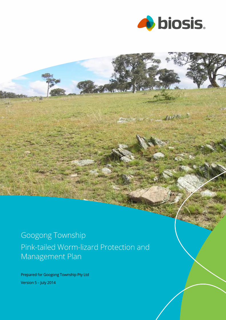
Googong Township
Pink-tailed Worm-lizard Protection and Management Plan
Prepared for Googong Township Pty Ltd
Version 5 – July 2014
© Biosis 2014 – Leaders in Ecology and Heritage Consulting i
Biosis Pty Ltd
This document is and shall remain the property of Biosis Pty Ltd. The document may only be used for
the purposes for which it was commissioned and in accordance with the Terms of the Engagement for
the commission. Unauthorised use of this document in any form whatsoever is prohibited.
Disclaimer:
Biosis Pty Ltd has completed this assessment in accordance with the relevant federal, state and local
legislation and current industry best practice. The company accepts no liability for any damages or
loss incurred as a result of reliance placed upon the report content or for any purpose other than that
for which it was intended.
Biosis offices
AUSTRALIAN CAPITAL TERRITORY
Canberra
Floor 1, Unit 3, 38 Essington Street
Mitchell ACT 2911
Phone: (02) 6241 2333
Fax: (02) 6280 8752
Email: [email protected]
NEW SOUTH WALES
Sydney
Unit 14, 17-27 Power Avenue
Alexandria NSW 2015
Phone: (02) 9690 2777
Fax: (02) 9690 2577
Email: [email protected]
Wollongong
8 Tate Street
Wollongong NSW 2500
Phone: (02) 4229 5222
Fax: (02) 4229 5500
Email: [email protected]
QUEENSLAND
Brisbane
Suite 4 First Floor, 72 Wickham Street
Fortitude Valley QLD 4006
Phone: (07) 3831 7400
Fax: (07) 3831 7411
Email: [email protected]
VICTORIA
Ballarat
506 Macarthur Street
Ballarat VIC 3350
Phone: (03) 5331 7000
Fax: (03) 5331 7033
Email: [email protected]
Melbourne (Head Office)
38 Bertie Street
Port Melbourne VIC 3207
Phone: (03) 9646 9499
Fax: (03) 9646 9242
Email: [email protected]
Wangaratta
16 Templeton Street
Wangaratta VIC 3677
Phone: (03) 5721 9453
Fax: (03) 5721 9454
Email: [email protected]
Document information
Report to: Googong Township Pty Ltd
Prepared by: Robert Speirs
Biosis project no.: 13402 → 16561 → 18082
File name: 18082.GoogongTownship.PTWL-P&MP.FinalV5.RES06072014
Citation: Biosis (2014). Googong Township Pink-tailed Worm-lizard
Protection and Management Plan – Version 5. Prepared for Googong
Township Pty Ltd. Author: R. Speirs, Biosis Pty Ltd, Canberra. Project 18082.
Acknowledgements
Biosis acknowledges the contribution of the following people and
organisations in undertaking this study:
Michael Nolan, Malcolm Leslie and Mark Attiwill (Googong
Township Pty Ltd)
Paul Keighley and Paula Nott (Manidis Roberts)
Rod Pietsch (NSW OEH)
The following Biosis staff have been involved in this project:
Jodie Cooper and Samantha Vertucci for assistance in the
field
James Shepherd and Ashleigh Pritchard for GIS analysis
and mapping
© Biosis 2014 – Leaders in Ecology and Heritage Consulting II
Document control
Version Internal review External review Date issued
Draft version 01 Daniel Gilmore Paul Keighley
Michael Nolan
02/09/2011
Draft version 02 - Googong Foreshores-Township
Interface Working Group
22/09/2011
Draft version 03 for public comment - Paul Keighley
Mark Attiwill
DSEWPaC
29/09/2011
Draft version 04 (for DSEWPaC final review) - Paula Nott
Michael Nolan
01/11/2011
Final version 01 (for Ministerial endorsement) - Paula Nott
Michael Nolan
18/11/2011
Final version 02 (for Ministerial endorsement) - Michael Nolan
DSEWPaC
04/07/2012
Final version 03 (revision to address NSW
EP&A Act approval)
- Chontelle Perucich
Rod Pietsch (NSW OEH)
25/06/2013
Final version 04 (revision to address IWC
infrastructure staging requirements)
- Michael Nolan 29/04/2014
Final version 05 (revision to address NH1B
planning and design requirements)
- Michael Nolan 06/07/2014
© Biosis 2014 – Leaders in Ecology and Heritage Consulting III
Contents
Abbreviations and Common Terms .................................................................................................................... v
1. Introduction ................................................................................................................................................. 1
1.1 Purpose........................................................................................................................................................................... 1
1.2 Background .................................................................................................................................................................... 2
1.3 Structure of this PTWL-P&MP .................................................................................................................................... 4
2. Establishment, Protection and Management of the PTWL Conservation Area ............................... 5
2.1 The PTWL Conservation Area concept .................................................................................................................... 5
2.1.1 Conservation principles ................................................................................................................................... 5
2.1.2 Design and location of the PTWL Conservation Area ............................................................................... 5
2.1.3 Management zones ......................................................................................................................................... 6
2.1.4 Key threats and management priorities ..................................................................................................... 7
2.2 PTWL Establishment Works and Management by GTPL ..................................................................................... 7
2.2.1 Establishment of the PTWL Conservation Area boundary and fencing ............................................... 7
2.2.2 Weed removal ................................................................................................................................................ 10
2.2.3 Physical removal of Radiata Pine and thinning of Burgan ................................................................... 11
2.2.4 Translocation of habitat resources and PTWL individuals ................................................................... 11
2.2.5 Re-establishment and encouragement of native grasses .................................................................... 12
2.2.6 Additional management measures during construction ..................................................................... 13
2.3 Monitoring and Management by GTPL ................................................................................................................ 13
2.3.1 Weed monitoring and management......................................................................................................... 13
2.3.2 Monitoring of native grass re-establishment success ........................................................................... 13
2.3.3 Monitoring of PTWL abundance and distribution .................................................................................. 14
2.3.4 Management of herbivores and feral predators .................................................................................... 14
2.3.5 Prevention of domestic animal impacts upon PTWL ............................................................................ 15
2.3.6 Public education and community engagement ...................................................................................... 15
2.4 Perpetual Monitoring and Management by Council ......................................................................................... 16
2.4.1 Ongoing weed monitoring and management ........................................................................................ 16
2.4.2 Monitoring of native grass re-establishment success ........................................................................... 16
2.4.3 Monitoring of PTWL abundance and distribution .................................................................................. 16
2.4.4 Ongoing deterrence of unrestrained domestic animal access to the PTWL Conservation Area 16
2.4.5 Legal mechanisms to protect the PTWL Conservation Area in perpetuity ....................................... 17
3. Consultation and Review of this PTWL-P&MP ...................................................................................... 18
3.1 Consultation undertaken during the development of this PTWL-P&MP ...................................................... 18
3.1.1 Googong Township Foreshores Interface Working Group .................................................................. 18
3.1.2 Further consultation undertaken during 2011 ....................................................................................... 18
3.2 Public and agency comment on the draft PTWL-P&MP ................................................................................... 18
© Biosis 2014 – Leaders in Ecology and Heritage Consulting IV
3.3 Ongoing review of this PTWL-P&MP ..................................................................................................................... 19
4. Summary of Management Actions and Responsibilities ................................................................... 20
Figures .................................................................................................................................................................... 23
References ............................................................................................................................................................. 30
Appendix A: Background to the PTWL at Googong ........................................................................................ 32
Appendix B: Submissions received during Public Exhibition of the PTWL-P&MP ..................................... 36
Appendix C: Submissions received during consultation under Part 3A Project Approval ...................... 42
Appendix D: Section 88B Instrument ................................................................................................................ 43
List of Tables
Table 1: Relevant Conditions of Approval for the protection and management of the PTWL ..................... 1
Table 2: PTWL Conservation Area management zones ..................................................................................... 6
Table 3: PTWL Conservation Area management summary ............................................................................. 20
Table 4: Issues raised in submissions received during the exhibition of the final draft PTWL-P&MP ...... 36
Table 5: Issues raised in comments received from NSW Office of Environment and Heritage ................. 42
© Biosis 2014 – Leaders in Ecology and Heritage Consulting v
Abbreviations and Common Terms
ACT TAMS ACT Government Territory and Municipal Services Directorate
AHD Australian Height Datum
APZ Asset Protection Zone
CEMP Construction Environmental Management Plan
Council Queanbeyan City Council
DECCEW ACT Department of Environment, Climate Change, Energy and Water
DSEWPaC Commonwealth Department of Sustainability, Environment, Water,
Population and Communities (Department of the Environment from
September 2013 onwards)
EEC Endangered Ecological Community
EP&A Act Environmental Planning and Assessment Act 1979
EPBC Act Environment Protection and Biodiversity Conservation Act 1999
EPI Environmental Planning Instrument
Googong IWC Project Googong township Integrated Water Cycle Project
Googong township The area encompassed by Googong township
GTPL Googong Township Pty Ltd
LEP Queanbeyan Local Environmental Plan 2012
LGA Local Government Area
NPWS NSW National Parks and Wildlife Service (part of the OEH)
OEH NSW Office of Environment and Heritage
PTWL Pink-tailed Worm-lizard
PTWL Conservation Area The area of the Study Area proposed to be dedicated and managed as a
conservation area for Pink-tailed Worm-lizard
Study Area The area of Googong township assessed as supporting PTWL habitat during
the 2010 surveys
TSC Act Threatened Species Conservation Act 1995
sp. species (singular)
spp. species (plural)
ssp. subspecies
var. variety
VPA Voluntary Planning Agreement
© Biosis 2014 – Leaders in Ecology and Heritage Consulting 1 1
1. Introduction
1.1 Purpose
The Commonwealth Department of Sustainability, Environment, Water, Population and Communities
(DSEWPaC) approved the development of Googong township (on 19 May 2011) subject to a number of
Conditions of Approval (CoA). CoA 1 related to the protection and management of the Pink-tailed Worm-lizard
(Aprasia parapulchella) (PTWL) within Googong township. CoA 1 has been addressed in this document in the
manner detailed in Table 1 below.
The Googong township Integrated Water Cycle Project (Googong IWC Project), which includes construction
and operation of a water recycling plant as well as potable water and wastewater services for the township,
was approved by the NSW Department of Planning and Infrastructure on 24 November 2011. Table 1 also
includes the relevant NSW Project Approval CoA related to the protection of the PTWL.
Table 1: Relevant Conditions of Approval for the protection and management of the PTWL
Condition of Approval 1 Section/s
CoA 1 as per the EPBC Approval
The person taking the action must prepare and submit a Pink-tailed Worm-lizard Protection and
Management Plan for the Minister’s approval for the protection of Pink-tailed Worm-lizard (Aprasia
parapulchella). The plan must include:
Entire document
i. Details of the establishment of the Pink-tailed Worm-lizard Conservation Area; 2.1
2.2.1
ii. Management measures to mitigate construction impacts; 2.2.1
2.2.4
2.2.6
iii. Measures for the management of the Pink-tailed Worm-lizard Conservation Area for before and
after the conservation area’s dedication to Queanbeyan City Council or other appropriate authority;
2.2
2.3
2.4
iv. Maps showing fences and other infrastructure; Figure 4
v. Details of legal mechanisms to protect the conservation area in perpetuity; and 2.4.5
vi. Provision for public comment on the draft plan. 3.2
The plan must be submitted to the Minister for written approval within 6 months of the date of this
approval.
4.0
The person taking the action must not commence construction within 50 metres of Pink-tailed Worm-lizard
habitat until the Minister has approved the plan.
2.2.1
Figure 2
The approved Pink-tailed Worm-lizard Protection and Management Plan must be implemented. 3.2
4.0
CoA B14 as per the Project Approval under Section 75J of the NSW Environmental Planning & Assessment Act 1979.
The Proponent shall establish and maintain in perpetuity a dedicated area of land on the project site for the
conservation of the Pink-tailed Legless Lizard (Aprasia parapulchella) as outlined in the plan prepared in
Entire document
© Biosis 2014 – Leaders in Ecology and Heritage Consulting 2 2
Condition of Approval 1 Section/s
accordance with condition D9 and shown in Appendix 2.
CoA D9 as per the Project Approval under Section 75J of the NSW Environmental Planning & Assessment Act 1979.
The Proponent shall prepare and implement an Aprasia Conservation Management Plan for the project to
provide and maintain habitat for the Pink-tailed Legless Lizard in accordance with condition B14. This plan
must be prepared in consultation with OEH and DSEWPaC, and be submitted to the Director-General for
approval by the end of June 2012. The plan must:
Entire document
(a) be prepared or peer reviewed by a suitably qualified ecologist; Prepared by
Robert Speirs
(Biosis)
Peer reviewed by
Dr Will Osborne
(University of
Canberra)
(b) be based on the recommendations in the EA and the objectives of the National Recovery Plan for the
species;
Appendix A
(c) outline the roles and responsibilities of parties that would implement the plan Table 3
(d) set out the appropriate objectives, actions and milestones for the Proponent, prior to handing over
ownership of this land to Queanbeyan City Council;
2.1.1
(e) include:
(i) procedures to survey and mark the boundary of the conservation area and a 20 meter buffer
zone;
2.1
(ii) procedures for the establishment and maintenance of boundary fencing, including measures to
promote kangaroo grazing;
2.1
(iii) procedures and success criteria for habitat restoration and weed management; 2.3.2
2.3.3
(v) a community education program; 2.3.6
(vi) procedures to achieve long-term security for the conservation area; 2.4
(vii) a program to monitor the Pink-tailed Legless Lizard population within the conservation area;
and
2.3
(viii) a program which sets out milestone dates for achieving the actions and measures in the plan. Table 3
1.2 Background
Googong township is a new master-planned town for a population of some 16,000 people, which will be
constructed over the next twenty years. The vision is for a new, vibrant and sustainable community with an
economic town centre and strong sense of place.
Approval for Googong township has been achieved through three different approval pathways, outlined as
follows:
© Biosis 2014 – Leaders in Ecology and Heritage Consulting 3 3
Approval to develop Googong township subdivision, urban development works and the Googong IWC
Project was granted under sections 130(1) and 133 of the Commonwealth Environment Protection and
Biodiversity Conservation Act 1999 (EPBC Act) on 19 May 2011.
For the approval of all infrastructure relating to the potable water, recycled water and sewage system
for the township, an environmental assessment was prepared under (the now repealed) Part 3A of
the NSW Environmental Planning and Assessment Act 1979 (EP&A Act) to assess the impacts of
construction and operation of infrastructure. On 24 November 2011, a Concept Approval for the
ultimate development (Stage 1 and Stage 2) and a Project Approval for Stage 1 of the Googong IWC
Project was granted by the NSW Planning Assessment Commission, under delegation from the
Minister for Planning and Infrastructure. Stage 1 of the Project comprises the following infrastructure:
– a water recycling plant (WRP);
– temporary reservoirs for recycled and potable water;
– pumping stations for sewage, recycled water and potable water;
– mains pipework (including rising and distribution mains) for sewage, recycled water and
potable water to connect to Neighbourhood 1A (NH1A); and
– connection to the stormwater management system.
For the development of NH1A, approval was gained from Queanbeyan City Council (QCC) under Part
4 of the EP&A Act. NH1A includes construction of the subdivision and associated infrastructure
including stormwater, roads, civil works and utilities.
To satisfy the relevant conditions of approval from the above described approvals, Biosis Pty Ltd (previously
'Biosis Research Pty Ltd') was engaged by the Googong Development Corporation (now 'Googong Township
Pty Ltd' (GTPL)) in 2010 to prepare an assessment of the impacts of Googong township upon an area of
known PTWL habitat occurring within the eastern extent of the township (refer to Figure 1). In order to inform
this assessment, habitat quality mapping was completed and intensive targeted rock-turning surveys were
conducted throughout the areas determined to constitute potential habitat for the species. PTWL habitat
throughout the Study Area was mapped according to ranking criteria that incorporated the abundance and
density of surface rocks as well as vegetation composition. Using these ranking criteria, the Study Area was
segmented into areas of ‘Very High’, ‘High’, ‘Medium’ and ‘Low’ quality habitat for the PTWL.
The results of the field surveys and habitat mapping were used to inform the preparation of an assessment
against the EPBC Act Significant Impact Criteria (Commonwealth of Australia 2008) and to make
recommendations for the design and ongoing management of a proposed PTWL Conservation Area. In
accordance with the recommendations provided, GTPL proposed to establish, rehabilitate and dedicate to
public ownership, a 52 ha PTWL Conservation Area within Googong township. The proposed PTWL
Conservation Area included the entire area mapped as ‘Very High’ quality habitat, the majority of the ‘High’
quality habitat and ‘Medium’ quality habitat as well as proposing to restore and protect areas of ‘non-habitat’,
strategically located to increase habitat connectivity and reduce ‘edge-effects’ (refer to Figures 2 and 3). The
EPBC Act Significant Impact Criteria assessment concluded that the proposed development of Googong
township would be unlikely to result in a significant impact upon the PTWL, provided the proposed PTWL
Conservation Area is established and appropriately managed in perpetuity.
As such, this approach to the management of the PTWL within Googong township was proposed by GTPL in
the submission of an EPBC Act Referral of the proposed action to DSEWPaC for assessment of Googong
township against the provisions of Part 9 of the EPBC Act.
© Biosis 2014 – Leaders in Ecology and Heritage Consulting 4 4
1.3 Structure of this PTWL-P&MP
This PTWL-P&MP is structured in the following manner:
Section 2 – Details regarding the establishment, protection and management of the PTWL Conservation Area.
Within Section 2:
Subsection 2.1 details the PTWL Conservation Area concept including the conservation principles,
design and location, and the proposed management zones;
Subsection 2.2 details the initial works and management actions to be undertaken by GTPL;
Subsection 2.3 details the monitoring and management of the PTWL Conservation Area to be
undertaken by GTPL; and
Subsection 2.4 details the monitoring and management of the PTWL Conservation Area to be
undertaken in perpetuity by Queanbeyan City Council (Council).
Section 3 – Details regarding the consultation and review undertaken during the preparation and to be
undertaken during implementation of this PTWL-P&MP:
Subsection 3.1 details the consultation undertaken during the development of this PTWL-P∓
Subsection 3.2 details the provision that has been made for public and agency comment on this
PTWL-P∓ and
Subsection 3.3 details the ongoing review procedure for this PTWL-P&MP.
Section 4 – A summary of the management actions to be undertaken and the parties responsible.
© Biosis 2014 – Leaders in Ecology and Heritage Consulting 5 5
2. Establishment, Protection and Management of the PTWL
Conservation Area
2.1 The PTWL Conservation Area concept
2.1.1 Conservation principles
The following four principles recommended by Biosis and independently endorsed by PTWL expert Dr Will
Osborne have been applied by GTPL in determining the location design, establishment and management of
the PTWL Conservation Area within Googong township:
including, and thereby preventing the disturbance of, all areas of ‘Very High’ quality habitat and the
majority of the areas of ‘High’ and ‘Medium’ quality habitat within the PTWL Conservation Area;
providing a balanced outcome of urban development and a consolidated, contiguous PTWL
Conservation Area that reduces habitat fragmentation and improves habitat quality for the species in
the long term;
optimising the habitat connectivity of the PTWL Conservation Area to the adjoining Googong
Foreshores; and
implementing an ongoing management regime that will effectively manage the PTWL Conservation
Area for the conservation of the PTWL, whilst remaining fiscally responsible and practicable to
implement and manage.
These principles have been considered by GTPL as ‘objectives’ to be met during the design and management
of Googong township in order to facilitate development, whilst ensuring the development does not have a
‘significant impact’ (as defined pursuant to the EPBC Act) upon the population of PTWL.
2.1.2 Design and location of the PTWL Conservation Area
The PTWL Conservation Area that will be established by GTPL (as illustrated in Figures 2 and 3) has been
designed in a manner that will result in a qualitative and quantitative long-term net-benefit to PTWL habitat
within the locality. With regard to the location and extent of the PTWL Conservation Area, it should be noted
that of the PTWL habitat assessed as occurring within Googong township, the PTWL Conservation Area will
encompass the following.
1. The entire 24.2 ha area of ‘Very High’ quality habitat.
2. The majority (6.25 ha or 65.2%) of the ‘High’ quality habitat. The loss of the balance 3.33 ha or 34.8%
of ‘High’ quality habitat will be effectively compensated for by restoring and protecting ‘Medium’
quality habitat and areas of ‘non-habitat’, strategically located to increase habitat connectivity and
reduce ‘edge-effects’.
3. The majority (15.71 ha or 66.1%) of the area of ‘Medium’ quality habitat. The retained areas will be
restored and, over time, become higher quality habitat.
As such, the PTWL Conservation Area proposed by GTPL will, in time, encompass a total of approximately 54
ha containing a minimum of approximately 46.16 ha of ‘Very High’ or ‘High’ quality habitat. This will result in a
substantial long-term net increase given that the total area of ‘Very High’ or ‘High’ quality habitat prior to the
establishment of the PTWL Conservation Area is 33.78 ha. In addition, the habitat restoration and
management measures detailed in this PTWL-P&MP will:
© Biosis 2014 – Leaders in Ecology and Heritage Consulting 6 6
substantially improve habitat quality within the PTWL Conservation Area;
maintain and improve habitat connectivity within the PTWL Conservation Area; and
improve habitat connectivity between the PTWL Conservation Area and the adjoining Googong
Foreshores.
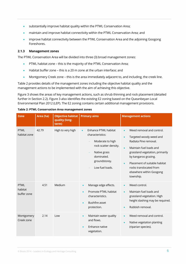
2.1.3 Management zones
The PTWL Conservation Area will be divided into three (3) broad management zones:
PTWL habitat zone – this is the majority of the PTWL Conservation Area;
Habitat buffer zone – this is a 20 m zone at the urban interface; and
Montgomery Creek zone – this is the area immediately adjacent to, and including, the creek line.
Table 2 provides details of the management zones including the objective habitat quality and the
management actions to be implemented with the aim of achieving this objective.
Figure 3 shows the areas of key management actions, such as shrub thinning and rock placement (detailed
further in Section 2.2). Figure 3 also identifies the existing E2 zoning based on the Queanbeyan Local
Environmental Plan 2012 (LEP). The E2 zoning contains certain additional management provisions.
Table 2: PTWL Conservation Area management zones
Zone Area (ha) Objective habitat
quality (long-
term)
Primary aims Management actions
PTWL
habitat zone
42.79 High to very high Enhance PTWL habitat
characteristics:
– Moderate to high
rock scatter density.
– Native grass
dominated.
groundstorey.
– Low fuel loads.
Weed removal and control.
Targeted woody weed and
Radiata Pine removal.
Maintain fuel loads and
grassland vegetation, primarily
by kangaroo grazing.
Placement of suitable habitat
rocks translocated from
elsewhere within Googong
township.
PTWL
habitat
buffer zone
4.51 Medium Manage edge effects.
Promote PTWL habitat
characteristics.
Bushfire asset
protection.
Weed control.
Maintain fuel loads and
grassland vegetation. High
height slashing may be required.
Rubbish removal.
Montgomery
Creek zone
2.14 Low Maintain water quality
and flows.
Enhance native
vegetation.
Weed removal and control.
Native vegetation planting
(riparian species).
© Biosis 2014 – Leaders in Ecology and Heritage Consulting 7 7
2.1.4 Key threats and management priorities
A risk management approach has been undertaken with regard to the design and management of the PTWL
Conservation Area, particularly with respect to the design, location and staging of the conservation area
fencing. The risks, based on the likelihood and consequences of potential impacts, were discussed and
agreed to by the Googong Foreshores-Township Interface Working Group on 9 September 2011. This risk
assessment was informed by the scientific advice from expert ecologists and utilised the experience of local
land managers. The management approach discussed in the remainder of this section is based on the
following threats to the conservation of the PTWL, in order of priority:
1. Trail bikes – the use of trail bikes within the PTWL Conservation Area is likely to disturb key habitat
features, such as small surface rocks.
2. Four-wheel-drive vehicles – similar to trail bikes, four-wheel-drive vehicles may disturb habitat
features. However, due to the steep topography throughout much of the PTWL Conservation Area
movement within the PTWL Conservation Area by such vehicles is limited.
3. Unleashed/feral dogs and cats – these animals may excavate under and around habitat rocks and
directly predate on PTWL individuals, however, the likelihood of this occurring is considered to be low.
4. Pedestrians – while the likelihood of people walking through areas of PTWL habitat is high, the level of
impact upon the species, which may result from human foot traffic and other pedestrian access
impacts is considered to be low.
5. Bush rock removal – while bush rock removal is recognised as a key threatening process to the PTWL,
the fencing type and schedule detailed in Section 2.2.1 will prevent unauthorised vehicular access to
the PTWL Conservation Area. Impacts associated with the removal of bush rocks without the aid of a
vehicle (i.e. carrying by hand from the PTWL Conservation Area to residential properties via Googong
Foreshores) are considered to be unlikely and of low significance.
With regard to all the above priority risks, it has been identified by the Googong Foreshores-Township
Interface Working Group that public education and community engagement is of key importance to the
protection of the PTWL Conservation Area and the minimisation of the risks/impacts detailed above. Section
2.3.6 details the public education and community engagement actions that will be undertaken.
2.2 PTWL Establishment Works and Management by GTPL
2.2.1 Establishment of the PTWL Conservation Area boundary and fencing
Boundary form and function
The boundary fence between the PTWL Conservation Area and the surrounding urban areas of Googong
township will be 1.8 m in height. To respond to the highest priority risks discussed in Section 2.1.4, the fence
will be constructed using chain mesh with galvanised posts and rails at the top and approximately 0.9 m. This
fence type is considered to be the most appropriate as it will:
not create a visually unappealing barrier between the PTWL Conservation Area and the adjacent
residential areas;
be effective in preventing illegal access into the PTWL Conservation Area (entry without a key would
require climbing over or cutting holes in the 1.8m boundary fence); and
provide some deterrent to domestic cats and dogs which may escape or roam from the surrounding
future residential areas.
© Biosis 2014 – Leaders in Ecology and Heritage Consulting 8 8
Legal pedestrian access to the PTWL Conservation Area (i.e. for passive recreation purposes such as
bushwalking, bird watching, etc) will only be made available via Googong Foreshores when open to the public
(generally 8am to 5pm). No formed access tracks or other facilities will be established within the PTWL
Conservation Area.
As shown in Figure 4, where the PTWL Conservation Area boundary meets the Googong Foreshores
boundary, the PTWL Conservation Area fence will join the fence that will be constructed between the urban
(residential) areas of the township and Googong Foreshores. This fence will be of the same type and form,
similarly designed in a manner that will minimise the risk of pest fauna species, illegal vehicular and
pedestrian access into Googong Foreshores.
Existing fencing between the PTWL Conservation Area and the adjoining Googong Foreshores will be
removed to allow for the free movement of kangaroos, wallabies and wombats between the conservation
area and Googong Foreshores. An appropriate level of grazing by native herbivores will greatly assist in
maintaining the grassland habitat desirable to PTWL and reduce fuel loads.
Maintaining and monitoring the fence around the PTWL Conservation Area to prevent illegal access into the
PTWL Conservation Area will also prevent such access into Googong Foreshores. Upon construction of the
adjacent residential properties, community surveillance of the PTWL Conservation Area will provide a
considerable deterrent to people wishing to enter the PTWL Conservation illegally.
Gates with a six metre wide opening will be installed in the fence at a number of locations along the
boundary, strategically chosen in order to provide emergency and other authorised access into the PTWL
Conservation Area. The type and form of these gates will be consistent with that of the adjoining fence and
they will be constructed in a manner that does not result in them becoming a weak point in the fence.
A 20 m wide ‘buffer zone’ will be established running around the inside of the boundary of the PTWL
Conservation Area (refer to Figure 3). This buffer zone will be monitored during the twice-annual (spring and
autumn) weed monitoring and management program (refer Section 2.3.1) and any disturbance or additional
weed establishment/encroachment will be promptly and sensitively controlled. Alike the balance of the PTWL
Conservation Area, the buffer zone will be managed for PTWL conservation and, as such, will not be used as a
transport corridor, or other incompatible use. However, the buffer zone may form part of the asset protection
zone (APZ) for adjacent residential properties and, as such, may be managed as an Outer Asset Protection
Area in accordance with Planning for Bushfire Protection - A Guide for Councils, Planners, Fire Authorities and
Developers (NSW Rural Fire Service 2006), which entails maintaining fuel loads at less than eight (8) tonnes
per hectare (ha). It should be noted that it is expected that in this environment, no additional measures are
expected to be required to maintain such fuel loads. Notwithstanding this, asset protection for residences
located opposite the PTWL Conservation Area will be primarily achieved by the road reserve and measures to
be implemented within the residential properties. As previously stated, grazing by native herbivores at the
desirable intensity to optimise PTWL habitat quality will also greatly reduce fuel loads within the PTWL
Conservation Area.
In the event that native herbivore grazing is insufficient to maintain the required fuel loads within the buffer
zone, slashing may be undertaken within the buffer zone to maintain fuel loads to Outer Protection Area
standards. Slashing equipment will be thoroughly cleaned of all potentially weed seed laden material prior to
entry and cutter blades will be set high enough to avoid rocks.
The boundary between the PTWL Conservation Area and the adjacent surrounding future residential
development areas will be the area where 'edge effects' are most relevant and will require the highest degree
of ongoing management. As such, all reasonable efforts have been made during the design of the PTWL
Conservation Area to minimise the length of the boundary between the PTWL Conservation Area and the
adjacent surrounding future residential development areas. This was achieved through the design of the
© Biosis 2014 – Leaders in Ecology and Heritage Consulting 9 9
PTWL Conservation Area in accordance with the principles discussed in Section 2.2.1 and on the advice of
relevant experts. In particular, this related to consolidation of habitat areas to reduce fragmentation by
restoring areas within the PTWL Conservation Area, thereby providing increased habitat connectivity and
quality within the PTWL Conservation Area and improving habitat connectivity to the adjoining Googong
Foreshores. This process is illustrated in Figures 2 and 3, particularly on the southern side of Montgomery
Creek.
Sealed edge roads will be constructed around the majority of the boundary of the PTWL Conservation Area
with residential lots located on the opposite side of the road. The location of roads in this manner is effective
in discouraging the dumping of rubbish and the often well intentioned (however highly environmentally
degrading) practice of spreading lawn clippings throughout the grassland over the back fence. In order to
avoid the establishment of additional exotic plants and to prevent increases in the proportion of those
already present, disturbance to the topsoil between the road and the PTWL Conservation Area boundary
fence will be minimised. Should the placement of additional soil be required in this area, this soil will be
sourced from adjacent areas and will be seeded with local native grasses. The use of soil sourced in this
manner will assist in preventing the introduction of additional exotic plant species into the locality.
With regard to the above, given the topography of the area, the delivery of a full edge road is not practicable
along a section of the boundary of the northern part of the PTWL Conservation Area. As such, a six (6) metre
wide formed gravel fire trail will be established along this section between the PTWL Conservation Area and
the adjoining residential lots (refer Figure 5). Whilst not comprising part of the PTWL Conservation Area (and
thus not being subject to the measures of this PTWL-P&MP), the fire trail will be fenced into the PTWL
Conservation Area with the 1.8m boundary fence located between the fire trail and the adjoining lots. As
such, for the relevant section of the PTWL Conservation Area boundary, the boundary fence will be moved six
metres outwards to encompass the fire trail, however the PTWL Conservation Area boundary will remain
unchanged (as illustrated in Figures 2, 3 and 5). The fire trail will be locked at either end and will provide
access to authorised parties only, primarily for bushfire management, land maintenance and to monitor the
interface.
Boundary establishment schedule
The trigger for establishment is the commencement of residential subdivision works for Googong township
within 50 m of the identified PTWL habitat. This trigger is considered to mark ‘Year 0’ of the PTWL
Conservation Area and all works to establish the PTWL Conservation Area will proceed in stages from this
point. Figure 2 provides the indicative ‘Year 0’ trigger line.
In accordance with the above, the relevant section of the PTWL Conservation Area boundary will be defined
and fenced prior to any residential subdivision construction works commencing within 50 m of the relevant
section of the identified PTWL Habitat. Fence construction will then proceed in stages, generally as per the
diagrammatic representation provided in Figure 4.
The current land use and management regime (i.e. for agricultural purposes, notably sheep grazing) has been
in place throughout the PTWL Conservation Area and surrounds for an extended period. This land use and
management regime will continue until ‘Year 0’ will occur as it will best allow for the maintenance of the PTWL
habitat quality and the PTWL population within. The existing stock fencing within the PTWL Conservation Area
and immediate vicinity will also remain without substantial alteration until ‘Year 0’ (Note: this does not
preclude routine maintenance or replacement of the existing fences, if required). The continuation of the
current land use and the retention of the existing stock fencing will also preclude public access to the PTWL
Conservation Area prior to its formal establishment.
In relation to Stage 1 of the Googong IWC Project, Sewage Pumping Station 2 (SPS2) will be the closest
infrastructure construction works to the PTWL Conservation Area (refer to Figure 6). As illustrated in Figure 6,
© Biosis 2014 – Leaders in Ecology and Heritage Consulting 10 10
SPS2 and its associated construction footprint will be located within the Year 0 trigger line and construction
works (scheduled to commence in July 2014) will result in the disturbance of PTWL habitat. As also illustrated
in Figure 6, the sewer rising main and the two gravity sewer mains which will connect to SPS2 will also be
partly located within the Year 0 trigger line. Whilst located within the Year 0 trigger line, the commencement
of the establishment of the PTWL Conservation Area will not be triggered by the construction of SPS2 and
associated sewer mains given the following.
1. SPS2 is a component of the Googong IWC Project, infrastructure works which must be completed
prior to the development of the remainder if Neighbourhood 1A or any of Neighbourhood 1B.
Similarly, the gravity sewer mains are required to service Neighbourhood 1A. The Googong IWC
Project works and the gravity sewer mains for Neighbourhood 1A are quite discrete from the
residential subdivision construction works that will occur within the Year 0 trigger line for
Neighbourhood 1B. In this regard, residential construction works for Neighbourhood 1B are not
scheduled to commence until May 2015.
2. The area of PTWL habitat disturbance that will occur for the construction of the sewer infrastructure
(SPS2 and associated sewer mains) is well defined and will be limited to the minimum required to
allow for the practicable construction of the infrastructure. In this regard, disturbance for the
construction of the sewer infrastructure will be confined to the construction works footprint as
illustrated in Figure 6. If all PTWL habitat within this defined 'maximum' construction footprint is
disturbed it would result in the disturbance of 0.42 ha of 'Medium' quality habitat and 0.03 ha of 'Low'
quality habitat.
3. The sewer infrastructure construction works will not result in the provision of public access to the
PTWL Conservation Area or immediate surrounds. Only those parties specifically engaged to work on
the construction project will be permitted to access the works area. All such staff and contractors will
be inducted as described in Section 2.2.6 and educated regarding the PTWL Conservation Area and
the relevant protection measures required of the particular construction personnel.
4. The construction of sewer infrastructure will not introduce or proliferate any of the 'key threats and
management priorities' listed in Section 2.1.4.
5. The 'Translocation of habitat resources and PTWL individuals' (including the 'importation of habitat
rocks' and 'PTWL salvage and translocation program') as detailed in Section 2.2.4 will be implemented
for the area of PTWL habitat disturbed for the sewer infrastructure construction.
6. A construction exclusion fence will be established between the sewer infrastructure construction
footprint and the PTWL Conservation Area boundary. As illustrated in Figure 6, the fence will run
parallel to and at least five metres from the PTWL Conservation Area boundary. The construction
exclusion fence will be constructed of sturdy materials, fit for purpose and maintained for the
duration of construction works.
↓
2.2.2 Weed removal
Post establishment of the PTWL Conservation Area boundary, all woody weeds (i.e. Sweet Briar (Rosa
rubiginosa) and African Boxthorn (Lycium ferocissimum)) will be removed (via poisoning and physical removal)
from the PTWL Conservation Area.
A targeted weed removal program (spot spraying) has been implemented to control the Serrated Tussock
(Nassella trichotoma) (approximately 50 plants were identified in 2010) located along the Montgomery Creek
riparian zone within the PTWL Conservation Area. In January 2013 the 50 plants were located and sprayed
with Glyphosate (with blue marker dye). These plants will be checked during spring 2013 to ensure a
© Biosis 2014 – Leaders in Ecology and Heritage Consulting 11 11
thorough kill was achieved. Any plants remaining alive and any others located within the PTWL Conservation
Area were sprayed at this time. Eradication of this weed species is essential to prevent its spread and
proliferation throughout the PTWL Conservation Area. As such, GTPL will continue to undertake the control
works required to eradicate Serrated Tussock within the PTWL Conservation Area.
All weed removal works will be undertaken by trained and competent personnel using weed management
techniques that are targeted to the species with minimal impact upon non-target species.
Specific efforts to eradicate or substantially reduce the other exotic grass and herbaceous species (primarily
pasture species and common rural species), which are widespread throughout the PTWL Conservation Area
are unwarranted. These species are generally considered ‘naturalised’ throughout the rural areas of the
Southern Tablelands and, as such, efforts to eradicate them would be largely futile given their abundance
throughout the wider locality. The removal of stock and associated nutrification of the soils, combined with
the re-establishment and appropriate grazing of native grasses is likely to reduce the prominence of many of
the exotic grasses and herbs within the PTWL Conservation Area.
↓
2.2.3 Physical removal of Radiata Pine and thinning of Burgan
The Radiata Pine (Pinus radiata) planted along the gully in the eastern part of the PTWL Conservation Area
(refer to Figure 3) will be physically removed. The trees will be sawn at the base, felled and removed from the
PTWL Conservation Area. The tree stumps will remain in place to minimise soil disturbance and erosion. If
trees are chipped onsite the resulting mulch will be removed and not dumped or distributed within the PTWL
Conservation Area.
The areas within the PTWL Conservation Area which support dense stands of Burgan (Kunzea eriocoides) will
be thinned (refer to Figure 3). Burgan bushes will be sawn at the base and removed from the PTWL
Conservation Area. Care will be taken to minimise disturbance to the soil surface and avoid disturbance to
areas supporting substantial rock scatter density.
The thinning of dense stands of Burgan will also reduce shading of PTWL habitat, encouraging the growth of
Kangaroo Grass and other native groundstorey species, which increase habitat quality for the PTWL. Reduced
shading also increases the thermoregulatory benefit offered by habitat rocks to PTWL, and thus, increases
their utilisation of these important habitat features. It should be noted, however, that the thinning of Burgan
will not become a widespread operation, nor will it aim to remove or substantially reduce the presence of the
species within the PTWL Conservation Area or the very extensive adjoining Googong Foreshores.
↓
2.2.4 Translocation of habitat resources and PTWL individuals
Importation of habitat rocks
Suitable habitat rocks removed by GTPL during the construction of the edge road and other excavations
within the immediate vicinity of the PTWL Conservation Area will be imported into the PTWL Conservation
Area. These rocks will then be scattered throughout the existing areas devoid of suitable habitat rocks or
where such rocks are at low scatter density (refer to Figure 3). The rocks used for importation will be selected
due to their small and/or flat characteristics. Large or spherical rocks will not be imported. Rocks will be
scattered in a manner that results in a moderate to high scatter density whilst ensuring that rocks are not
piled and do not result in excess of 30% ground cover. Care will be taken to avoid existing rocky areas and to
minimise soil disturbance during delivery and scattering of these rocks.
© Biosis 2014 – Leaders in Ecology and Heritage Consulting 12 12
To prevent the importation of additional weed species into the PTWL Conservation Area, only rocks removed
from adjacent sections of Googong township will be imported.
PTWL salvage and translocation program
Prior to the importation of rocks discussed above, any PTWL individuals uncovered outside of the PTWL
Conservation Area within the existing habitat area (refer to Figure 2) will be translocated into the PTWL
Conservation Area. It is important to note as the majority of high quality habitat and recorded locations of
PTWL will be located within the PTWL Conservation Area, the numbers of PTWL individuals identified for
translocation are expected to be low (and may be nil). This proposed salvage and translocation process is not
essential to the overall protection of the PTWL or to the success of the PTWL Conservation Area, however, it
will be undertaken as an additional conservation measure.
A licence to conduct the PTWL salvage and translocation program will be obtained from the NSW Office of
Environment and Heritage (OEH) by a suitably qualified ecologist engaged by GTPL. Any specific conditions of
this licence will be adhered during the conduct of the program. The OEH (Queanbeyan Office) will be notified
of the proposed timing of the PTWL salvage and translocation program.
The PTWL salvage and translocation program will involve the turning (by a suitably qualified and experienced
ecologist or similar) of all suitable habitat rocks and the capture of all PTWL found. Captured PTWL individuals
will immediately be taken into the adjoining PTWL Conservation Area and released at the base of a suitable
habitat rock located at least 20 m inward from the boundary. Care will be taken to ensure that the PTWL is
able to make its way under the selected rock.
To prevent increases in competition in areas of existing habitat within the PTWL Conservation Area, all
individuals translocated into the PTWL Conservation Area will be released in the areas of newly
created/improved habitat (i.e. areas where imported rocks have been placed).
In order to maximise the number of individuals salvaged, if possible the PTWL salvage and translocation
program should be completed when the conditions are suitable to survey for the species (i.e. <28 degree
Celsius sunny days in spring or autumn).
In addition to the PTWL salvage and translocation program, protocols to be adhered to if PTWL are
discovered during construction works are to be included in the site induction for all construction personnel
working directly adjacent to the PTWL Conservation Area. The protocol that will be followed is to pause the
activity and contact the relevant person on site nominated to capture and remove the PTWL encountered.
The nominated person must be reasonably familiar with PTWL (i.e. be able to distinguish between a PTWL
and a juvenile snake, etc). Upon notification, the nominated person will capture by hand (wearing gloves), and
release the PTWL within the PTWL Conservation Area, as described above.
2.2.5 Re-establishment and encouragement of native grasses
A native grass re-establishment and encouragement program will be implemented throughout the PTWL
Conservation Area. This will be aimed at facilitating and encouraging the dominance of native grasses (notably
Kangaroo Grass and Red Grass) within the areas of the PTWL Conservation Area where they are not currently
the dominant species due to Burgan cover or disturbance.
The program will involve the re-establishment of Kangaroo Grass and Red Grass using stock grown from seed
of local provenance (i.e. ACT and surrounds). These grasses will be re-established or boosted via the
spreading of fertile Kangaroo Grass and Red Grass seed across the sections of the PTWL Conservation Area
where disturbance to the soil surface has occurred during the removal of exotic and native woody species
and the importation of habitat rocks. The native grass re-establishment and encouragement program will
occur as soon as practicable following the completion of these works.
© Biosis 2014 – Leaders in Ecology and Heritage Consulting 13 13
2.2.6 Additional management measures during construction
In addition to the specific management measures detailed herein, the following standard construction best
practice management measures will be adhered during all works within or adjacent to the PTWL
Conservation Area, as follows:
1. Construction sites will be fenced for site security and safety reasons. No construction vehicles or
personnel will be permitted outside of the construction site fencing.
2. A Construction Environmental Management Plan (CEMP) will be prepared for the management of
environmental issues during construction. Relevant sections of the CEMP will be prepared to detail
the protection of ecological features of Googong township, including the location of the PTWL
Conservation Area. The CEMP will also detail general environmental protection measures, such as
sediment and erosion control measures to be undertaken during construction activities.
3. Construction personnel will be inducted. Inductions (and less formal, task-specific actions, such as
‘toolbox talks’) will include, where relevant, the location of the PTWL Conservation Area and the
relevant protection measures required of the particular construction personnel. Generally, this will
entail construction personnel being informed to remain within the designated construction
sites/areas at all times.
4. In order to prevent the importation of additional weed species into the locality, all vehicles will be
cleaned of all potentially seed laden material prior to entry.
5. Construction personnel will not bring any domestic pets into the site.
6. All rubbish will be removed from site and disposed at an appropriately licenced facility. No rubbish
will be burned, buried or otherwise disposed of on site.
2.3 Monitoring and Management by GTPL
2.3.1 Weed monitoring and management
A twice-annual (spring and autumn) weed monitoring and management program will be implemented to
identify any regrowth of woody weeds and to locate any Serrated Tussock (or other ‘Weed of National
Significance’) that may have re-established within the PTWL Conservation Area. Any such regrowth or re-
establishment will be immediately eradicated using appropriate removal techniques.
All weed monitoring and removal works will be undertaken by trained and competent personnel using weed
management techniques targeted to the species with minimal impact upon any non-target species.
2.3.2 Monitoring of native grass re-establishment success
The success of the native grass re-establishment and encouragement program will be determined through
the conduct of monitoring events by appropriately qualified and experienced personnel (botanist, ecologist,
bush regenerator, etc), undertaken biannually (spring and autumn) following the spreading of the grass seed.
The biannual monitoring events will continue until Kangaroo Grass and Red Grass combined comprise a
minimum of 25% of the groundstorey cover within the re-establishment areas. At each monitoring event, one
(1) 4 m2 (i.e. 2 m x 2 m) sampling plot per 1000 m
2 will be randomly located within each re-establishment area.
The groundstorey biomass percentage of Kangaroo Grass and Red Grass within each sampling plot will be
estimated and used to produce an average biomass percentage for the species within the polygon. If the
biomass percentage is insufficient, further seed spreading or infill planting with these species will be
undertaken to achieve the desired coverage.
© Biosis 2014 – Leaders in Ecology and Heritage Consulting 14 14
It is envisaged that in the absence of stock grazing it is likely that Kangaroo Grass and Red Grass will readily
establish and quickly become the dominant grass species within the re-establishment areas.
2.3.3 Monitoring of PTWL abundance and distribution
A PTWL monitoring program will be implemented to monitor the abundance and distribution of the PTWL
throughout the PTWL Conservation Area.
The PTWL monitoring program will involve the turning of rocks across the entire PTWL Conservation Area and
the recording of all PTWL individuals identified (i.e. numbers, locations recorded via GPS, etc). The survey
effort to be completed will amount to approximately 15 hours of survey effort (i.e. two (2) ecologists for one
(1) day), and, as such, the pace at which the survey staff move around the PTWL Conservation Area will need
to be established accordingly.
Monitoring survey effort will be expended in a manner that provides a sample of habitat qualities ranging
from ‘Medium’ to ‘Very High’, and specifically encompassing areas where habitat creation/improvement (i.e.
rock placement areas and native grass re-establishment areas) has occurred.
The PTWL monitoring program has been designed in a manner that will involve a measured amount of survey
effort (i.e. 15 hours per survey event) spread at low intensity across the entire PTWL Conservation Area. Given
the inherent disturbance to habitat involved in rock turning surveys, this approach will distribute the
disturbance across a large area, and thereby, prevent the same specific areas being repetitively disturbed (as
would be the case if defined survey plots were established).
The results of each monitoring event will be provided for inclusion in the NSW Wildlife Atlas as per the
standard conditions of the scientific licence held by the ecologist/zoologist engaged to conduct the
monitoring.
The PTWL monitoring program will commence in the spring following the first year of residential subdivision
construction works within 50 m of the PTWL Conservation Area. The program will then occur every second
year using the same survey techniques at each survey event until handover of the PTWL Conservation Area to
Council. The commencement of the PTWL monitoring program, as stated, will provide for a number of
monitoring events to occur and allow for baseline results to be obtained prior to the substantial occupation of
the adjacent future residential areas.
Notwithstanding the above, an additional 'preliminary' monitoring event was conducted during spring 2013
prior to the PTWL monitoring program commencing. The purpose of this monitoring event was to collect
further baseline PTWL population data prior to any potential impacts from the early stages of Googong
township being felt within the PTWL Conservation Area. The results of the spring 2013 monitoring event have
been added to Figure 2.
The PTWL monitoring program will provide invaluable data regarding the continued viability of the PTWL
population and hopefully demonstrate that the conservation and protection of the PTWL Conservation Area
(and associated works) has increased the size and secured the viability of the PTWL population in the long-
term.
Whilst the PTWL monitoring program will be conducted in accordance with the above, a degree of flexibility
will be maintained to allow for the incorporation of new or better survey techniques should these become
known/developed in the future. Any such changes will be documented at the time of the review of this PTWL-
P&MP, which is to occur at least every five (5) years.
2.3.4 Management of herbivores and feral predators
The feral herbivore European Rabbit (Oryctolagus cuniculas) was detected within the PTWL Conservation Area
during the 2010 surveys. This species has been identified as an invasive species which suppresses the
© Biosis 2014 – Leaders in Ecology and Heritage Consulting 15 15
regeneration of natural grasses and forbs (NSW Scientific Committee 2002). High intensity grazing by rabbits
is likely to adversely impact upon PTWL habitat by reducing the abundance of native grasses. In addition, the
excavation of burrows and establishment of latrine sites by rabbits is likely to result in disturbance of PTWL
habitat and increased weed infestation.
Whilst important for the maintenance of biomass and fuel loads, overgrazing by over-abundant kangaroo
populations within the PTWL Conservation Area and the adjoining Googong Foreshores also has the potential
to impact negatively upon the quality of the PTWL habitat.
Feral Cats (Felis catus) and the Red Fox (Vulpes vulpes) are known to predate upon small reptiles, including
those of the family Pygopodidae. The impacts of these predators must be appropriately managed to protect
the PTWL and other native fauna within the PTWL Conservation Area.
Given that herbivores and feral predators will move freely between Googong Foreshores and the PTWL
Conservation Area, populations of herbivores and feral predators in the locality will be managed effectively by
the existing and ongoing operations undertaken by the ACT Government Territory and Municipal Services
(ACT TAMS) (Googong Foreshores Draft Plan of Management 2007).
2.3.5 Prevention of domestic animal impacts upon PTWL
The following measures will be implemented to prevent domestic animals from roaming within the PTWL
Conservation Area, as follows:
1. A public education and community engagement program will be developed and implemented (refer
to Section 2.3.6).
2. A sealed edge road will be located between the PTWL Conservation Area and adjacent residential
properties along the majority of the interface
3. The PTWL Conservation Area boundary fence will be installed to provide a deterrent to domestic
animals through the installation of chain mesh fencing (refer to Section 2.2.1). This fence will be
appropriately maintained.
2.3.6 Public education and community engagement
A public education and community engagement program will be implemented by GTPL to educate the
residents of, and the visitors to, Googong township. This program will provide the following:
1. Signage at strategic locations along the PTWL Conservation Area boundary providing details relating
to the:
a. biodiversity values of the PTWL Conservation Area and importance of protecting such values;
b. management activities that have occurred and will continue to occur within the PTWL
Conservation Area;
c. roles that the public can play in protecting the PTWL Conservation Area;
d. actions that will damage the PTWL Conservation Area and/or diminish the habitat values of the
area to PTWL (i.e. recreational rock turning, bush rock collection, weed introduction, etc); and
e. party responsible for the management of the area and who members of the public should
contact should they observe illegal or degrading activities being conducted within or
immediately adjacent to the PTWL Conservation Area.
© Biosis 2014 – Leaders in Ecology and Heritage Consulting 16 16
2. A section to be included within a welcome brochure (or similar) supplied to new residents and
displayed in other relevant locations (Googong Foreshores visitor centre, community billboards, etc)
detailing the above.
2.4 Perpetual Monitoring and Management by Council
The PTWL Conservation Area will be maintained by GTPL at its cost until the completion of the development
(issue of a subdivision certificate for creation of the 5,550 lots in Googong township). Prior to or at the time of
the completion of the development (which is estimated to take 25 years), the PTWL Conservation Area will be
dedicated to Council. This constitutes the binding arrangement incorporated into the Voluntary Planning
Agreement (VPA) being made by GTPL and Council. GTPL will work collaboratively with Council to manage the
handover of the native grass re-establishment program and the other management measures established by
GTPL. The handover will also ensure compliance with Project Approval CoA D9(vi), which requires procedures
to achieve long term security for the PTWL Conservation Area. The specific management measures that will
continue in perpetuity under the management of Council are detailed below.
2.4.1 Ongoing weed monitoring and management
The twice-annual (spring and autumn) weed monitoring and management program will continue in
perpetuity. This program will identify any regrowth of woody weeds and locate any Serrated Tussock (or other
‘Weed of National Significance’) that may have re-established within the PTWL Conservation Area. Any such
regrowth or re-establishment will be immediately eradicated using appropriate techniques.
As previously stated, all weed monitoring and removal works will be undertaken by trained and competent
personnel using weed management techniques targeted to the species with minimal impact upon non-target
species.
The 20 m wide buffer will continue to be regularly monitored and any disturbance or additional weed
establishment/encroachment will be promptly and sensitively controlled. The use and management
measures established by GTPL throughout the PTWL Conservation Area will not substantially alter upon
handover to Council. That is, the entire PTWL Conservation Area will continue to be managed for the
conservation of the PTWL.
2.4.2 Monitoring of native grass re-establishment success
It is anticipated that the objectives of the native grass revegetation program will be met prior to handover to
Council. In this case, Council will not be required to conduct specific monitoring of the re-establishment area,
however, it will conduct annual reviews of the vegetation cover and condition throughout the PTWL
Conservation Area. Should handover occur prior to the minimum of 25% of the groundstorey biomass
objective being met throughout the re-establishment areas, Council will ensure that any required additional
seed spreading or infill plantings will be undertaken following handover.
2.4.3 Monitoring of PTWL abundance and distribution
The PTWL monitoring program will continue following handover to Council. The methodology and survey for
the monitoring program will remain unchanged and continue to occur once every five (5) years in perpetuity.
2.4.4 Ongoing deterrence of unrestrained domestic animal access to the PTWL Conservation Area
The measures implemented by GTPL to deter domestic animals from roaming within the PTWL Conservation
Area will remain in place under the management of Council, specifically:
the public education and community engagement program, including signage, will continue; and
the PTWL Conservation Area boundary fence will be maintained in order to deter domestic animals.
© Biosis 2014 – Leaders in Ecology and Heritage Consulting 17 17
2.4.5 Legal mechanisms to protect the PTWL Conservation Area in perpetuity
Prior to commencement of construction within 50 metres of the PTWL Conservation Area, an 88b Instrument
is to be registered over the land, requiring the owners of the Conservation Area to maintain it pursuant to the
terms of the Protection and Management Plan. The 88b Instrument shall be generally in accordance with that
included in Appendix D but may be registered in two stages for the portions of the Conservation Area on
either side of Montgomery Creek. The Minister is to be notified upon registration of the 88b Instrument prior
to the commencement of construction within 50 metres of the Conservation Area. If the 88b Instrument is
registered in stages, the Minister is to be notified upon registration of each stage.
The dedication of the land for the PTWL Conservation Area is detailed within the Voluntary Planning
Agreement (VPA) for Googong township. Following handover of the PTWL Conservation Area to Council, the
PTWL Conservation Area will irrevocably become publicly owned land. It will then be the responsibility of
Council to classify the land as community land and prepare a plan of management in accordance with the
requirements of section 36 of Part 2 of the Local Government Act 1993. This will further enable the PTWL
Conservation Area to be protected in perpetuity and provide Council with the authority to manage the land as
an asset. This irrevocable dedication of the PTWL Conservation Area to public ownership will ensure that the
land can not be used for another purpose in the future.
Additionally, future development can not occur within the PTWL Conservation Area, without the permission of
Council or other relevant authority (as this would not be in accordance with the VPA). If such a proposal were
to be put forward, it would be subject to the provisions of the EPBC Act with respect to protection of PTWL
and its habitat, and a likely referral under the EPBC Act (as it would not be in accordance with Googong
township EPBC referral, as approved) would be required.
Upon approval by the (Commonwealth) Minister in July 2012, the management measures and actions
described herein became requirements of the approval under the EPBC Act. The Department of the
Environment may conduct compliance audits and may implement enforcement measures, if these
requirements are not satisfactorily adhered.
Furthermore, the poaching of PTWL or the unapproved disturbance of the habitat of threatened species in
NSW is a criminal offence and offenders may be prosecuted in accordance with the provisions of the
Threatened Species Conservation Act 1995 (TSC Act).
© Biosis 2014 – Leaders in Ecology and Heritage Consulting 18 18
3. Consultation and Review of this PTWL-P&MP
3.1 Consultation undertaken during the development of this PTWL-P&MP
3.1.1 Googong Township Foreshores Interface Working Group
As part of the EPBC Act referral for the township, a Googong Foreshores Township Interface Working Group
(the 'Working Group') was formed in mid-2010 to undertake alignment between the commitments that were
being proposed in the various planning approval documents and the existing Googong Foreshores Draft Plan
of Management (ACT Government Territory and Municipal Services 2007). Parties represented in the Working
Group include:
CIC Australia/GTPL.
Commonwealth Department of Finance.
Commonwealth Department of the Environment.
ACT Government Territory and Municipal Services Directorate.
ACTEW Corporation/ActewAGL.
Queanbeyan City Council.
The Working Group has developed broad objectives and specific actions, such as the location of fencing,
which have been incorporated into this PTWL-P&MP. Relevant members of the Working Group have also
been consulted further on specific aspects related to the protection and management of the PTWL. A meeting
of the Working Group was held on 9 September 2011 specifically to review the first draft of this PTWL-P&MP.
Subsequent proposed revisions of this PTWL-P&MP have been presented to the Working Group members for
their review and comment at biannual (May and November) meetings.
3.1.2 Further consultation undertaken during 2011
In order to finalise the EPBC Act referral and ensure the ongoing protection of the PTWL, several meetings
were held with DSEWPaC in early 2011. During this time, additional consultation and peer review was also
undertaken with Dr Will Osborne, an expert on the PTWL in the ACT and surrounding region of NSW. Further
consultation has been conducted more recently with Dr Osborne in relation to the specific measures
contained within this PTWL-P&MP.
3.2 Public and agency comment on the draft PTWL-P&MP
In accordance with CoA 1, provision was made for public comment on the final draft PTWL-P&MP.
A copy of the final draft PTWL-P&MP was placed on public exhibition for a two (2) week period from 1 October
to 14 October 2011. Public notices were placed in the Queanbeyan Age and Canberra Times newspapers
advertising the commencement of the public exhibition period and providing details for the submission of
response(s) following review of the PTWL-P&MP. An electronic copy of the PTWL-P&MP was also provided to
DSEWPaC, Council, NSW Office of Environment and Heritage (Queanbeyan Office), Friends of Grasslands
(FoG) and Dr Osborne for their review and comment.
Three (3) submissions were received on the review of the final draft PTWL-P&MP. Appendix B provides a list of
the issues raised in the submissions received and their consideration. A number of minor amendments to
this PTWL-P&MP have been undertaken following consideration of these submissions.
© Biosis 2014 – Leaders in Ecology and Heritage Consulting 19 19
3.3 Ongoing review of this PTWL-P&MP
This PTWL-P&MP is subject to review at least every five (5) years. Reviews will be undertaken to provide for
adaptive management and to ensure that the objectives of the PTWL Conservation Area are being suitably
achieved. The review will be conducted by GTPL prior to handover to Council and by Council post handover.
GTPL and Council may conduct the review in-house if suitable expertise is available or engage another
suitably qualified specialist/organisation.
© Biosis 2014 – Leaders in Ecology and Heritage Consulting 20 20
4. Summary of Management Actions and Responsibilities
A summary of the management actions and responsible parties for each management action is provided in
Table 3. Timings noted start with the ‘Year 0’ (being the year that residential subdivision construction works
first occur within 50 m of the identified PTWL habitat (refer to Figure 2 for the ‘Year 0‘ trigger line). For
example, if residential subdivision construction works commence beyond the ’Year 0‘ trigger line in 2015, then
‘Year 1’ becomes 2016 and thereon. As detailed in Section 2.2.1 and illustrated in Figure 5, whilst located
within the 'Year 0' trigger line, the commencement of the establishment of the PTWL Conservation Area will
not be triggered by the limited infrastructure construction works to occur for SPS2 and associated sewer
mains.
Table 3: PTWL Conservation Area management summary
Management action Timing and details Responsible party
Preparation of the PTWL-
P&MP
Submission to the DSEWPaC for Ministerial approval by 19 November
2011 (as per the requirements of Condition of Approval 1).
GTPL
Preparation of the PTWL-
P&MP
(referred to as an Aprasia
Conservation Management
Plan)
Prepared in consultation with OEH and DSEWPaC and submitted to
the Director-General for approval by the end of June 2012 (as per the
requirements of CoA D9.
GTPL
Continuation of farming
activities and retention of
existing stock fencing
The current management and use of the PTWL Conservation Area for
agricultural purposes (notably sheep grazing) will continue without
substantial alteration until ‘Year 0’.
The existing stock fencing within the PTWL Conservation Area and
immediate vicinity will remain without substantial alteration until ‘Year
0’. Note: this does not preclude routine maintenance or replacement
of the existing fences if required.
Private land
owner/manager
Establishment and
boundary fencing (Stage 1)
Precise boundary delineation to be determined during detailed design
of the relevant section of Googong township.
Fencing of the relevant section (Stage 1) of the PTWL Conservation
Area to be constructed prior to residential subdivision construction
works occurring within 50 m of the PTWL Habitat (refer to Figure 2 for
the ‘Year 0’ trigger line).
Relevant existing internal fencing will be removed. Existing fencing will
be retained where required for access and land management
purposes, particularly south of Montgomery Creek.
A construction exclusion fence will be established between the sewer
infrastructure construction footprint and the PTWL Conservation Area
boundary. As illustrated in Figure 5, the fence will run parallel to and at
least five metres from the PTWL Conservation Area boundary. The
construction exclusion fence will be constructed of sturdy materials, fit
for purpose and maintained for the duration of construction works.
GTPL
Weed removal, monitoring
and management
Removal of woody weeds to be undertaken following the construction
of the first section of PTWL Conservation Area fencing.
GTPL
© Biosis 2014 – Leaders in Ecology and Heritage Consulting 21 21
Management action Timing and details Responsible party
Small Serrated Tussock infestation to be eradicated within six (6)
months following the approval of this PTWL-P&MP.
Monitoring and management of weeds to be conducted on an
ongoing twice-annual basis by GTPL prior to handover and Council
and by Council post handover.
Commences in ‘Year 1’.
GTPL & Council
Importation of habitat
rocks
Suitable habitat rocks will be removed from the areas of habitat (refer
to Figure 2) outside of the PTWL Conservation Area and scattered
within the PTWL Conservation Area. This will occur primarily during
the works undertaken for the construction of the edge road.
Completed in ‘Year 1’.
GTPL
Translocation of PTWL In combination with the above importation of rocks, PTWL will be
translocated from identified habitat areas (refer to Figure 2), prior to
the commencement of construction in those areas. The PTWL
removed will be immediately translocated into the PTWL Conservation
Area and, to the extent possible, will occur during the suitable survey
season for the species (i.e. during suitable weather in spring or
autumn).
Completed in ‘Year 1’.
GTPL
Engaged ecologist
Monitoring of PTWL
abundance and
distribution
The PTWL monitoring program will commence the spring following
the first year of works within 50 m of the PTWL Conservation Area. The
program will then occur every second year until handover of the PTWL
Conservation Area to Council.
Following handover to Council, the PTWL monitoring program will
occur once every five (5) years in perpetuity.
Commences in ‘Year 1’.
GTPL & Council
Re-establishment and
encouragement of native
grasses.
Re-establishment and encouragement of native grasses throughout
the areas disturbed during woody vegetation removal and rock
placement will occur immediately following the completion of these
works, or following the completion of the section of these works.
Commences in ‘Year 2’.
GTPL
Monitoring of native grass
re-establishment
Monitoring of native grass re-establishment to be conducted on
biannual basis by GTPL prior to handover. Council will conduct annual
overview monitoring of the vegetation composition and condition
throughout the PTWL Conservation Area post handover.
Commences in ‘Year 3’.
GTPL & Council
Boundary fencing (Stage 2) Installation of Stage 2 of the PTWL Conservation Area fence (refer to
Figure 4) will be undertaken prior to the commencement of
construction works within 50 m of the PTWL Habitat (refer to Figure 2
for the ‘Year 0’ trigger line) south of Montgomery Creek.
GTPL
Physical removal of
Radiata Pine and thinning
of Burgan
Removal of Radiata Pine and thinning of Burgan will occur following
construction of Stage 2 of the PTWL Conservation Area fence (noted
above).
GTPL
© Biosis 2014 – Leaders in Ecology and Heritage Consulting 22 22
Management action Timing and details Responsible party
Review of the PTWL-P&MP The PTWL-P&MP will be reviewed at least every five (5) years. GTPL will be
responsible for this
review prior to
handover and
Council will be
responsible post
handover.
© Biosis 2014 – Leaders in Ecology and Heritage Consulting 23 23
Figures
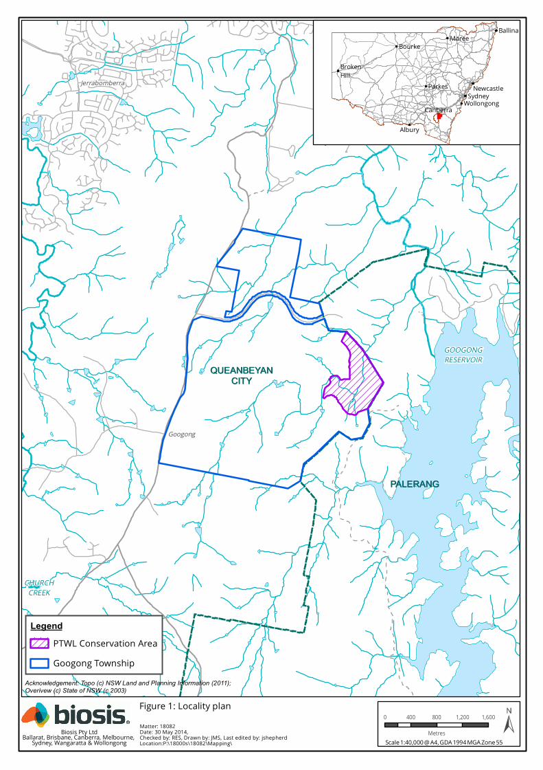
QUEANBEYANQUEANBEYANCITYCITY
PALERANGPALERANG
CHURCHCREEK
GOOGONGRESERVOIR
QUEANBEYANRIVER
Jerrabomberra
Googong
MoreeBourke
Parkes
CanberraSydney
Wollongong
Albury
Ballina
BrokenHill
Newcastle
Acknowledgement: Topo (c) NSW Land and Planning Information (2011); Overivew (c) State of NSW (c.2003)
Matter: 18082Date: 30 May 2014,Checked by: RES, Drawn by: JMS, Last edited by: jshepherdLocation:P:\18000s\18082\Mapping\
LegendPTWL Conservation AreaGoogong Township
Scale 1:40,000 @ A4, GDA 1994 MGA Zone 55
0 400 800 1,200 1,600
MetresBiosis Pty LtdBallarat, Brisbane, Canberra, Melbourne, Sydney, Wangaratta & Wollongong
Figure 1: Locality plan
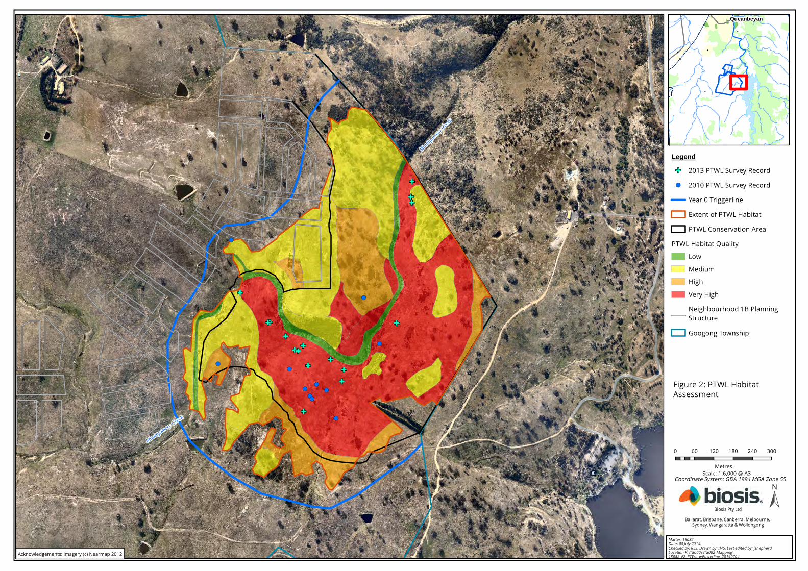
Monttgomery Creek
Monttgo
mery Creek
0 60 120 180 240 300
Metres
Legend2013 PTWL Survey Record2010 PTWL Survey RecordYear 0 TriggerlineExtent of PTWL HabitatPTWL Conservation Area
PTWL Habitat QualityLowMediumHighVery HighNeighbourhood 1B PlanningStructureGoogong Township
Matter: 18082Date: 08 July 2014, Checked by: RES, Drawn by: JMS, Last edited by: jshepherdLocation:P:\18000s\18082\Mapping\18082_F2_PTWL_wPowerline_20140704
Biosis Pty LtdBallarat, Brisbane, Canberra, Melbourne,
Sydney, Wangaratta & Wollongong
Queanbeyan
Scale: 1:6,000 @ A3
Figure 2: PTWL HabitatAssessment
Coordinate System: GDA 1994 MGA Zone 55
Acknowledgements: Imagery (c) Nearmap 2012
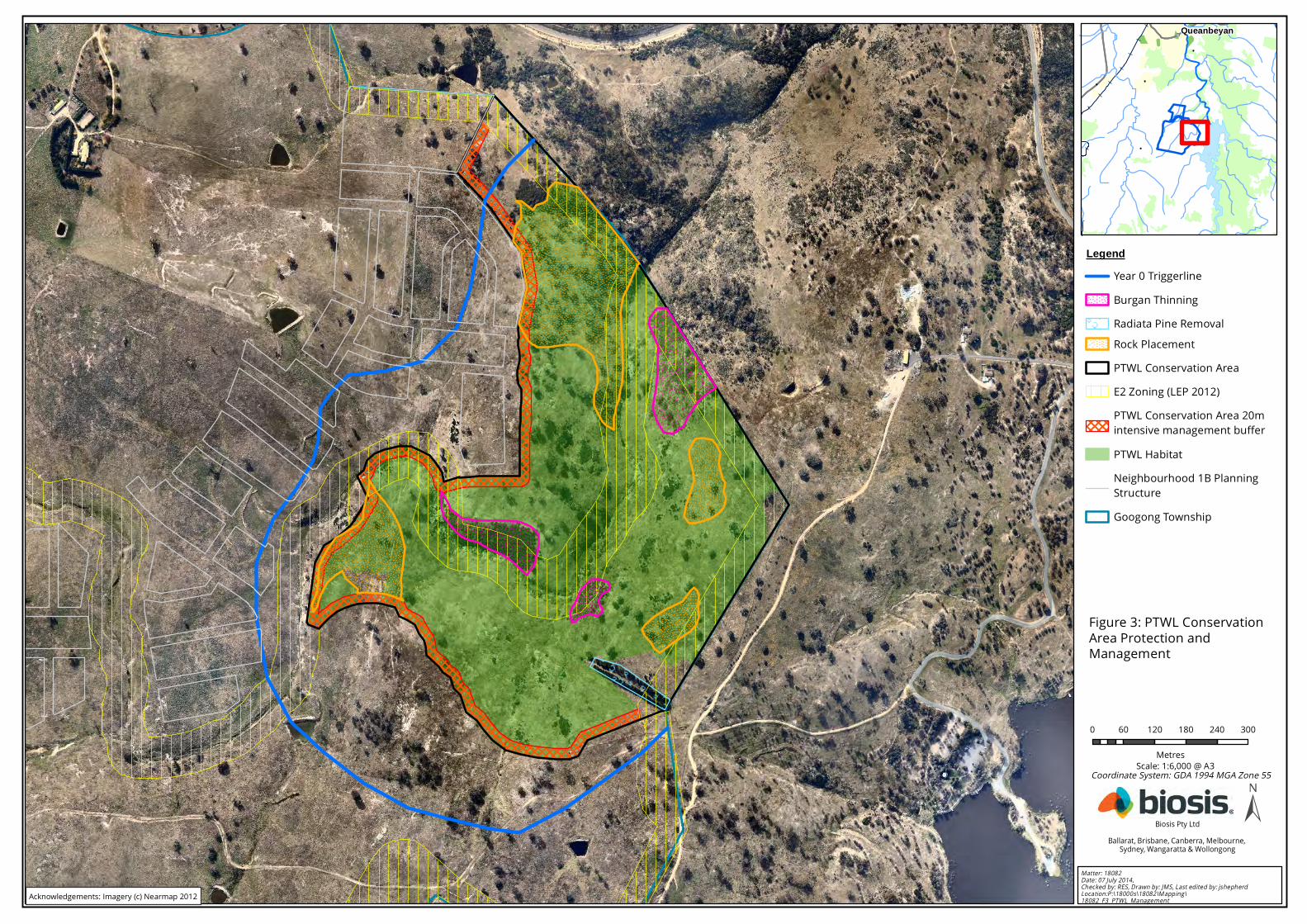
0 60 120 180 240 300
Metres
LegendYear 0 TriggerlineBurgan ThinningRadiata Pine RemovalRock PlacementPTWL Conservation AreaE2 Zoning (LEP 2012)PTWL Conservation Area 20m intensive management bufferPTWL HabitatNeighbourhood 1B PlanningStructureGoogong Township
Matter: 18082Date: 07 July 2014, Checked by: RES, Drawn by: JMS, Last edited by: jshepherdLocation:P:\18000s\18082\Mapping\18082_F3_PTWL_Management
Biosis Pty LtdBallarat, Brisbane, Canberra, Melbourne,
Sydney, Wangaratta & Wollongong
Queanbeyan
Scale: 1:6,000 @ A3
Figure 3: PTWL ConservationArea Protection andManagement
Coordinate System: GDA 1994 MGA Zone 55
Acknowledgements: Imagery (c) Nearmap 2012
Monttgomery Creek
Monttgo
mery Cree
k
0 60 120 180 240 300
Metres
Legend
Year 0 Trig g erlinePTWL Conserv ation Area Fence– S tag e 1PTWL Conserv ation Area Fence– S tag e 2Goog ong Foreshore Fence –S tag e 1Goog ong Foreshore Fence –S tag e 3Existing FencesPTWL Conserv ation AreaNeig hb ourhood 1B PlanningS truc tureGoog ong Township
Matter: 18082Date: 07 July 2014, Chec ked b y: RES , Drawn b y: JMS , Last edited b y: jshepherdLocation:P:\18000s\18082\Mapping \18082_F4_PTWL_Fencing
Biosis Pty LtdBallarat, Brisb ane, Canb erra, Melb ourne, S ydney, Wang aratta & Wollong ong
Queanbeyan
S cale: 1:6,000 @ A3
Fig ure 4: PTWL Conserv ationArea Fencing Plan
Coordinate S ystem : GDA 1994 MGA Zone 55
Acknowledg em ents: Im ag ery (c) Nearm ap 2012
Disclaimer: Final boundaries are subject to final survey and design
0 10 20 30 40 50
MetresMatter: 18082Date: 07 July 2014, Checked by: RES, Drawn by: JMS, Last edited by: jshepherdLocation:P:\18000s\18082\Mapping\18082_F6_PTWL_BoundDetail
Biosis Pty LtdBallarat, Brisbane, Canberra, Melbourne, Sydney, Wangaratta & Wollongong
Acknowledgements: Imagery (c) Nearmap 2012Topo (c) NSW Land and Planning Information (2012)
LegendYear 0 TriggerlineRock PlacementPTWL Conservation AreaProposed PTWL conservationarea boundary fenceE2 Zoning (LEP 2012)PTWL Conservation Area 20m intensive management bufferPTWL HabitatNeighbourhood 1B PlanningStructureFire trail access gateFire trail accessGoogong Township
Scale 1:1,500 @ A3Coordinate System: GDA 1994 MGA Zone 55
Figure 5: Boundary Portion Detail - PTWL Conservation Area / Fire Trail
0 15 30 45 60 75
Metres
Legend2013 PTWL Survey Record2010 PTWL Survey RecordYear 0 TriggerlineExtent of PTWL HabitatPTWL Conservation Area
PTWL Habitat QualityLowMediumHighVery High
Sewer InfrastructureSPS2Gravity sewer mainSewer rising mainIWC Stage B network construction footprintGravity sewer main construction footprintConstruction exclusion fence
Matter: 17162Date: 30 May 2014, Checked by: RS, Drawn by: JMS, Last edited by: jshepherdLocation:P:\18000s\18082\Mapping\18082_F5_Phase1ConsWorks
Biosis Pty LtdBallarat, Brisbane, Canberra, Melbourne,
Sydney, Wangaratta & Wollongong
Queanbeyan
Scale: 1:1,500 @ A3
Figure 6: Sewer Infrastructure(SPS2 and Sewer Mains)
Coordinate System: GDA 1994 MGA Zone 55
Acknowledgements: Imagery (c) Nearmap 2012
© Biosis 2014 – Leaders in Ecology and Heritage Consulting 30 30
References
ACT Government (2005) 'A Vision Splendid of the Grassy Plains Extended: ACT Lowland Native Grassland
Conservation Strategy'. Action Plan 28'.
ACT Government (2007) 'Ribbons of Life: ACT Aquatic Species and Riparian Zones Conservation Strategy Action Plan
29'. Arts Heritage and Environment, Canberra.
ACT Government Territory and Municipal Services (2007) Googong Foreshores Draft Plan of Management 2007.
Biosis Research & Ecowise Environmental (2009) ‘Googong Water Cycle Project – Ecological Assessments –
Terrestrial Flora and Fauna’. A report to Canberra Investment Corporation.
Brown GW (2010) ‘National Recovery Plan for the Pink-tailed Worm-lizard Aprasia parapulchella’ (Draft for
comment May 2010).
Commonwealth of Australia (2008) EPBC Act Policy Statement 1.1 Significant Impact Criteria. Department of
Environment, Water, Heritage and the Arts.
DEC (2004) Threatened Biodiversity Survey and Assessment: Guidelines for Developments and Activities - Working
Draft, http://www.threatenedspecies.environment.nsw.gov.au/tsprofile/profile.aspx?id=10544.
DEC (2005) Pink-tailed Worm-lizard - Threatened Species Profile,
http://www.threatenedspecies.environment.nsw.gov.au/tsprofile/profile.aspx?id=10061.
DECC (2009) Pink-tailed Worm-lizard Aprasia parapulchella species profile,
http://threatenedspecies.environment.nsw.gov.au/tsprofile/profile.aspx?id=10061.
DEWHA (2008a) Aprasia parapulchella in Species Profile and Threats Database,
http://www.environment.gov.au/cgi-bin/sprat/public/publicspecies.pl?taxon_id=1665.
Jenkins BR (2000) 'Soil landscapes of the Canberra 1:100 000 Sheet.' Department of Land and Water
Conservation, Queanbeyan.
Johnstone Centre (2004) ‘Environmental Assessment – Googong Urban Investigation Area’. A report to Willana
Associates Pty Ltd.
Jones SR (1992) Habitat relationships, diet and abundance of the endangered Pygopodid (Aprasia parapulchella).
B.App.Sc (Hons) thesis. Applied Ecology Research Group, University of Canberra.
Jones SR (1999) Conservation biology of the pink-tailed worm lizard (Aprasia parapulchella). PhD thesis, Applied
Ecology Research Group, University of Canberra
Navin Officer (2003) ‘Googong Local Environmental Study – Cultural Heritage Component’. A report to Willana
Associates Pty Ltd.
NSW Rural Fire Service (2006) Planning For Bushfire Protection. A guide For Councils, Planners, Fire Authorities and
Developers.
NSW Scientific Committee (2002) Competition and Grazing by the Feral European Rabbit - Key Threatening Process
Listing, Department of Environment and Climate Change
Osborne WS, et al. (1991) ‘Distribution and conservation status of the endangered pink-tailed legless lizard (Aprasia
parapulchella)’. Research Report to ACT Parks and Conservation Service.
© Biosis 2014 – Leaders in Ecology and Heritage Consulting 31 31
Osborne WS and Coghlan R (2004) 'Distribution of the Pink-tailed Worm Lizard in the Lower Molonglo Valley, ACT,
with respect to strategic land planning'. Applied Ecology Research Group, University of Canberra.
Osborne WS and Jones SR (1995) 'Recovery plan for the Pink-tailed Worm Lizard Aprasia parapulchella. Technical
Report No.10.' ACT Parks and Conservation Service.
Queanbeyan Local Environmental Plan 2012.
Rauhala M (1993) 'The reptile, amphibian and mammal fauna of the Stony Creek Nature Reserve, Australian
Capital Territory. Technical Report No. 6.' ACT Government.
© Biosis 2014 – Leaders in Ecology and Heritage Consulting 32 32
Appendix A: Background to the PTWL at Googong
Description of the PTWL Conservation Area and Surrounds
The PTWL Conservation Area will encompass a section of Montgomery Creek and associated hillslopes
and will incorporate approximately 52 ha of land located within the Queanbeyan River catchment,
approximately 10 km south of Queanbeyan, New South Wales. The land to the west, northwest and
south of the PTWL Conservation Area is, in its current form, predominantly cleared of native woody
vegetation and has been subjected to grazing and pasture improvement.
Landform, topography and soils
The topography of the PTWL Conservation Area is dominated by a moderately to deeply incised section
of the Montgomery Creek valley. The surrounding elevated lands to the west, north and south generally
comprise gently undulating hills, which will be developed for Googong township. The elevation within the
PTWL Conservation Area ranges from 720 m Australian Height Datum (AHD) along the western boundary
to 640 m AHD at the point at which Montgomery Creek enters Googong Foreshores.
The geology of the local area consists of Silurian volcanics including the Colinton volcanics and the
Cappanana Formation (Jenkins 2000). There are various tuffs with minor siltstone, shale, sandstone and
limestone (Jenkins 2000). Soils within the Study Area are shallow, infertile, strongly acidic and moderately
drained, with outcropping granitic rock, predominantly granodiorite (Jenkins 2000).
Management history and current vegetation condition
The majority of Googong township was cleared of native tree cover by felling and firing carried out post
European settlement of the area during the early to mid nineteenth century (Navin Officer 2003). The
steepest sections of the Montgomery Creek hillslopes were not cleared, likely due to the skeletal nature
of the soils and difficult topography. As is evidenced by the existence of granite tors, scattered surface
rocks and the general unevenness of the landscape, it can be determined that the cleared land within
and directly adjoining the PTWL Conservation Area has not been subject to cultivation or levelling.
Excavation and soil movement within the vicinity of the PTWL Conservation Area appears to have been
limited to that associated with the construction of dams across the branches of Montgomery Creek,
upstream of the PTWL Conservation Area.
Notwithstanding the above, the PTWL Conservation Area and adjoining sections of Googong township
have been subject to grazing (notably by sheep) at various intensities for an extended period, likely
extending back to the onset of pastoralism post European settlement. The grassland/pasture throughout
the more open and flat land located to the west, northwest and south of the PTWL Conservation Area
has undergone substantial pasture improvement and modification. The resulting grassland/pasture in
the pasture improved areas, whilst supporting a native grass component (i.e. primarily Austrostipa spp.
and Austrodanthonia spp.), is dominated by exotic pasture grasses and weeds.
The groundstorey vegetation throughout the PTWL Conservation Area supports a much higher
proportion and diversity of native grasses and forbs. Whilst much of the PTWL Conservation Area
supports a component of exotic pasture grasses and weeds, native grasses and forbs represent a much
larger component of the groundstorey biomass. Kangaroo Grass (Themeda triandra) and other native
species more sensitive to intense grazing and elevated soil fertility, constitute a substantial component of
the groundstorey biomass throughout much of the PTWL Conservation Area. No evidence is present to
suggest that the land within the PTWL Conservation Area has been subject to a lower intensity grazing
regime (i.e. sheep grazing appears to have occurred throughout the entire eastern section of Googong
township). It can therefore be envisaged that the persistence of native grasses (notably Kangaroo Grass)
© Biosis 2014 – Leaders in Ecology and Heritage Consulting 33 33
and forbs has occurred primarily through the exclusion of pasture improvement management practices
carried out to elevate soil fertility ((i.e. spreading of fertiliser (especially superphosphate), incorporation
of clover and other exotic pasture species, etc)).
A number of dense stands of Burgan (Kunzea ericoides) occur within the PTWL Conservation Area. Burgan
is a large dense spreading Tea-tree like native shrub growing to approximately four metres in height.
Generally considered a pioneer species, it vigorously occupies areas devoid of groundstorey vegetation
and often inhibits the growth of native grasses and forbs.
With regard to the above, it can be determined that whilst the vegetation and landform within the PTWL
Conservation Area have been impacted upon by a long history of grazing, the land and associated
vegetation type and condition within the PTWL Conservation Area has not been degraded to the extent
of that located throughout the surrounding areas of Googong township. The management of the PTWL
Conservation Area for pastoral purposes has resulted in the introduction of exotic grasses, herbaceous
and woody weeds and has reduced the dominance of native groundstorey vegetation. In this regard, it
would reasonably be expected that the condition of the groundstorey vegetation and associated PTWL
habitat value throughout the PTWL Conservation Area would continue to degrade if the past and current
management regime was to be maintained into the future.
Ecology and Habitat of Pink-tailed Worm-lizard
The PTWL is a small fossorial reptile from the family Pygopodidae (legless lizards), which has a maximum
snout vent length of 14 cm and a total length of about 24 cm. PTWL is oviparous (egg laying) with a clutch
size of two. Females may need to reach an age of about three (3) or four (4) years before they can
reproduce. There is little data on the breeding behaviour of this species (Osborne and Coghlan 2004).
The PTWL is moderately common within the ACT region and is often the most abundant reptile at
locations within its defined habitat type (Osborne et al. 1991).
The species lives beneath surface rocks and occupies ant galleries where it feeds on ants, particularly
their eggs and larvae (Osborne and Jones 1995). Key habitat features for the presence of PTWL are a
cover of native grasses (particularly Kangaroo Grass), sparse or no tree cover, little or no leaf litter, and
scattered small rocks shallowly embedded in the soil surface (Osborne and Jones 1995).
In the Canberra region, the species is found in areas containing acid volcanic rock types - Late Silurian
acid volcanics - that are derived from decomposing rhyodacite, rhyolite or dacite or other Silurian
volcanic rocks (Osborne and Coghlan 2004). The distribution of the species is centred on the ACT and this
appears to be related to less soil (and rock) disturbance evidenced by the presence of a native grass
cover, particularly Kangaroo Grass, Red-leg Grass (Bothriochloa macra) and Wattle Mat-rush (Lomandra
filiformis) (Osborne and Jones 1995). The likelihood of occurrence of PTWL increases with increasing
cover of Kangaroo Grass, which is a key botanical indicator of suitable habitat in the ACT region, along
with Red-leg Grass and Wattle Mat-rush (Jones 1992, 1999; Osborne & Coghlan 2004). Alternatively,
dominance of speargrasses (Austrostipa falcata, A. bigeniculata) and Tussock Grass (Poa labillardieri)
decreases the likelihood of finding the species (Osborne and Coghlan 2004; ACT Government 2007; ACT
Government 2005).
PTWL habitat sites in the Queanbeyan region support native grassland, derived grassland and open and
dry woodland habitats, usually with many loose and partially embedded rocks. Ground cover is typically
dominated by Kangaroo Grass and wallaby grasses (Astrodanthonia spp.) (R. Rehwinkel pers. comm.).
Open woodland habitats are dominated by Yellow Box (Eucalyptus melliodora) and Blakely’s Red Gum (E.
blakelyi), while dry forest areas are dominated by Broad-leaved Peppermint (E. dives) and Candlebark (E.
rubida) (Brown 2010).
Notwithstanding, moderate numbers of disturbed sites dominated by exotic ground cover species, such
as Wild oats (Avena spp.), Fescues (Vulpia spp.), Flat weeds (Hypochaeris spp.) and Bromes (Bromus spp.)
© Biosis 2014 – Leaders in Ecology and Heritage Consulting 34 34
have been found to support at least some individuals, although it was not known if these sites support
viable populations (Osborne and Coghlan 2004).
Distribution of Pink-tailed Worm-lizard
Regional
The PTWL occurs in south-eastern Australia, where it is widely but patchily distributed from Gunnedah in
northern NSW through southern NSW and the ACT to Bendigo in central Victoria (Brown 2010). Other
locations within this geographic area include near Cooma, Yass, Albury, Cootamundra, Tarcutta and
Queanbeyan (DEWHA 2008a; DECC 2009). Records cover a wide altitudinal range, from about 200 m
altitude near Bendigo to over 800 m altitude in the ACT (Brown 2010).
Locality
The PTWL is regarded as moderately common within the ACT and region where it has a wide and
scattered distribution along the rocky hills and slopes of the Murrumbidgee, Molonglo and Queanbeyan
River corridors (Brown 2010). The PTWL has been widely recorded throughout Googong Foreshores and
surrounding areas (Johnstone Centre 2004). Surveys completed by the Johnstone Centre (2004)
throughout the wider locality (encompassing Googong township) recorded seventeen individuals at two
(2) locations: thirteen (13) within the “Talpa” property located within the Queanbeyan River catchment
approximately two kilometres to the north of the Study Area; and, four within the “McLean” property
located within the Jerrabomberra Creek catchment approximately three (3) kilometres to the west of the
PTWL Conservation Area.
Habitat assessments carried out during broader ecological surveys completed by Biosis Research (2009)
throughout Googong township identified the PTWL potential habitat associated with the lower reaches of
Montgomery Creek. This potential habitat (in addition to the previously recognised potential habitat on
Reservoir Hill) was surveyed by Biosis Research with two live PTWL and one slough (shed skin) being
recorded within the area to become the PTWL Conservation Area (Biosis Research & Ecowise
Environmental 2009). In order to more accurately determine the significance of the PTWL population
occurring along Montgomery Creek, in spring 2010 GTPL commissioned Biosis to conduct intensive
targeted surveys and prepare habitat quality mapping throughout the areas of previously identified
potential habitat. Approximately 6,200 suitably sized shelter rocks were turned and 13 live A.
parapulchella individuals and three sloughs (shed skins) were recorded.
Owing to the results and observations of the 2010 study and previous studies conducted by Biosis
Research (2009) and the Johnstone Centre (2004), the PTWL habitat associated with the lower reaches of
Montgomery Creek is considered to constitute the only considerable area of PTWL habitat within
Googong township.
Threats to Pink-tailed Worm-lizard
The main threats to PTWL as described in the ‘National Recovery Plan for the Pink-tailed Worm-lizard A.
parapulchella (Draft)’ (Brown 2010) are:
Habitat loss and fragmentation;
Removal of rocks;
Heavy grazing and trampling;
Invasion of habitat by weeds;
Modification of habitat i.e. tree planting, invasion of woody shrubs in native grasslands;
© Biosis 2014 – Leaders in Ecology and Heritage Consulting 35 35
Changed fire regimes, which lead to a change in vegetation structure;
Recreational activities; and
Predation by introduced predators.
© Biosis 2014 – Leaders in Ecology and Heritage Consulting 36 36
Appendix B: Submissions received during Public Exhibition of
the PTWL-P&MP
A copy of the final draft Pink-tailed Worm-lizard Protection and Management Plan (PTWL-P&MP) was placed
on public exhibition for a two (2) week period from 1 October to 14 October 2011. Public notices were placed
in the Queanbeyan Age and Canberra Times advertising the commencement of the public exhibition period
and providing details for the submission of response(s) to the PTWL-P&MP. An electronic copy of the PTWL-
P&MP was also provided to DSEWPaC, Queanbeyan City Council, NSW Office of Environment and Heritage
(Queanbeyan Office), Friends of Grasslands (FoG) and Dr Will Osborne for their review and comment.
Table 4 below provides a list of the issues raised in the three (3) submissions received and appropriate
consideration of these issues. Minor amendments to the PTWL-P&MP have been undertaken following the
consideration of these submissions.
Table 4: Issues raised in submissions received during the exhibition of the final draft PTWL-P&MP
Issue raised / opinion provided Consideration and response
Friends of Grasslands (FoG)
FoG provided the following points
regarding the PTWL-P&MP:
1. No concerns raised and
statement the plan covers all
of the elements that FoG
considers important in
conserving the PTWL and
maintaining its habitat.
2. Support the inclusion of the
20 m buffer zone outside the
area defined as ‘high quality
PTWL habitat’.
3. Express an interest in
viewing the results of the
proposed PTWL monitoring
program.
The approved PTWL-P&MP and any associated monitoring results will be provided
on Googong website.
Submission from member of the public
Mountain bikes (MTB) track
construction and formal access
(pedestrian) tracks are not included
as an identified threat in the plan. The
issue of erosion caused by the
creation of any informal tracks
(caused by walkers or MTBs) within
the PTWL Conservation Area is not
defined.
The purpose of the PTWL Conservation Area is to conserve, protect and manage a
substantial and viable area of PTWL habitat specifically for the conservation of this
species. Whilst people will not be specifically excluded from the PTWL
Conservation Area (access will be provided from Googong Foreshores), the area is
not proposed to become a reserve with ‘park-like’ facilities, aimed at catering for
pedestrian or other recreational access or usage.
A maintained 20 m buffer zone along the perimeter of the PTWL Conservation
Area will be provided primarily to reduce ‘edge effects’. It also will enable access to
the area for walking and serve as an asset protection zone (APZ). No formed
access tracks are proposed within the PTWL Conservation Area for pedestrian /
MTB (or other) usage.

© Biosis 2014 – Leaders in Ecology and Heritage Consulting 37 37
Issue raised / opinion provided Consideration and response
MTB and pedestrian access is unlikely to result in significant disturbance to the
PTWL Conservation Area or the PTWL protected within. Furthermore, the
construction of any formal (formed) access tracks within the PTWL Conservation
Area would result in significantly more disturbance and disconnection of PTWL
habitat than that caused by informal tracks that may be created by pedestrians or
occasional MTB passage.
As detailed in this PTWL-P&MP, the monitoring of the vegetation cover and
composition and the PTWL population within the PTWL Conservation Area will be
undertaken to ensure that the objectives set out in the PTWL-P&MP are achieved.
Section 2.2.1 of this PTWL-P&MP has been amended to reflect the above (i.e. that
no additional formed access tracks will be established within the PTWL
Conservation Area).
Use of imported topsoil for
restoration between the proposed
road and the PTWL habitat fence (of
the PTWL Conservation Area) would
result in weeds.
The PTWL-P&MP does not specify the use of ‘imported’ topsoil for restoration in
this area. The PTWL-P&MP specifies the requirement for the topsoil to not be
contaminated with weed seed.
However, the concern regarding the potential for nutrient enrichment and
associated proliferation of weeds is valid. As such, Section 2.2.1 has been
amended to state ‘In order to avoid the establishment of additional exotic plants
and to prevent increases in the proportion of those already present, disturbance
to the topsoil between the edge road and the PTWL Conservation Area boundary
fence will be minimised. Should the placement of additional soil be required in
this area, this soil will be sourced from adjacent areas and the area reseeded
using endemic grass seed. The use of soil sourced in this manner will assist in
preventing the introduction of ensure that no additional exotic plant species are
introduced into the locality.'
The loss of any medium or high value
habitat should not occur due to the
proposal. The location of the
proposed fencing should be situated
20 m from the (blue) ‘Year 0’ trigger
line (Figures 2 and 3) and be
extended to meet the existing
(Googong Foreshores) fence line in
the south of the proposed PTWL
Conservation Area.
The establishment, improvement and management of the PTWL Conservation
Area will occur as an ‘offset’ for the impacts upon PTWL that will result from the
development of Googong township. The PTWL Conservation Area and its
delineation has been determined and agreed in consultation with DSEWPaC (and
other stakeholders) throughout the EPBC Act referral process. The delineation and
proposed establishment of the PTWL Conservation Area was also independently
reviewed and endorsed by a recognised authority on the conservation of the
species (Dr W. Osborne). Whilst the establishment of the PTWL Conservation Area
will result in the removal of some areas of ‘High’ or ‘Medium’ quality habitat, all
areas of ‘Very High’ quality habitat will be retained, as considerable improvement
of habitat quality and connectivity is a primary objective of the design and
establishment of the PTWL Conservation Area and this PTWL-P&MP.
As stated in this PTWL-P&MP, the overarching objective of the PTWL Conservation
Area is to provide a ‘balanced outcome of urban development and a consolidated,
contiguous PTWL Conservation Area that reduces habitat fragmentation and
improves habitat quality for the species in the long term’. The approved design of
the PTWL Conservation Area has been determined in order to specifically meet
this outcome.
No change to the PTWL-P&MP is required to address this issue.
© Biosis 2014 – Leaders in Ecology and Heritage Consulting 38 38
Issue raised / opinion provided Consideration and response
NSW Office of Environment and Heritage (OEH)(Queanbeyan Office)
The commencement date for
implementation of the PTWL-P&MP
should be within 2 years of consent.
The schedule for implementation of this PTWL-P&MP has been determined in
accordance with the schedule for the staged development of Googong township.
This staged development and the corresponding staged establishment of the
PTWL Conservation Area is in accordance with the EPBC Act Conditions of
Approval.
The immediate establishment and management of the PTWL Conservation Area is
impracticable and unnecessary given the existing landuse and management
within and directly adjoining the PTWL Conservation Area will not substantially
change in the years prior to the establishment of the PTWL Conservation Area (i.e.
the land will continue to be fenced and managed for agricultural purposes,
primarily grazing). The extended past period of this landuse and management has
not prevented the persistence of a viable population of PTWL within a substantial
area of high quality PTWL habitat.
Removal of bush rock should be
identified as a management priority.
Whilst bush rock removal is recognised as a key threatened process to PTWL, the
fencing type and schedule detailed in Section 2.2.1 will prevent unauthorised
vehicular or pedestrian access to the PTWL Conservation Area. The collection of
rocks from the PTWL Conservation Area and removal on foot via Googong
Foreshores would be entirely impractical and therefore is not a considerable risk.
Prior to development, the land adjacent to the PTWL Conservation Area will
remain private property managed for agricultural purposes. Fencing of the
relevant boundary section will be completed prior to the commencement of the
adjacent residential development. As such, at no point prior to or following
establishment of the PTWL Conservation will unauthorised vehicular access be
permitted or be reasonably practical.
Section 2.1.4 of the PTWL-P&MP has been amended to specifically address
management of bush rock removal.
The legal mechanism and the
structures behind the conservation
agreement should be strengthened
to ensure the reserve is secured in
perpetuity.
The PTWL Conservation Area is a biodiversity offset for Googong township and
this area and its delineation has been determined and agreed in consultation with
DSEWPaC (and other stakeholders) throughout the EPBC Act referral process. The
establishment of the PTWL Conservation Area was based on recommendations to
exclude any development from areas identified as ‘Very High’ quality PTWL habitat
and the objective of providing a balanced outcome between development and the
long term improvement of PTWL habitat and reduction in fragmentation of the
species, whilst assisting in maintaining connectivity.
In addition, the PTWL Conservation Area will be handed over to Council and a plan
of management in accordance with the requirements of the Local Government Act
1993 will be prepared to provide for the protection of the land and the species in
perpetuity. The irrevocable dedication of the PTWL Conservation Area to Council
will ensure the area will not be used for another purpose in the future.
Section 2.4.5 of the PTWL-P&MP provides details of the legal mechanisms to
protect the PTWL Conservation Area in perpetuity.
Long-term funding availability. The long-term management and associated funding of the PTWL Conservation
© Biosis 2014 – Leaders in Ecology and Heritage Consulting 39 39
Issue raised / opinion provided Consideration and response
Area has been guaranteed through the development of a Voluntary Planning
Agreement (VPA) between GTPL and Council made in accordance with the
Environmental Planning and Assessment Act 1979. The VPA specifies the funding
arrangements for the PTWL Conservation Area (and the overall Googong
township) and provides that GTPL are to maintain all costs associated with the
establishment and ongoing management PTWL Conservation Area until the last
residential lots in the township are created (an approximate duration of 25 years).
It is noted that any development within Googong township is unable to proceed
unless it is in accordance with the requirements of this VPA.
Section 2.4.5 has been amended to state the above.
Monitoring plots should be
established to enable replication and
to prevent wide spread habitat
disturbance.
Monitoring survey effort will be expended in a manner that provides a sample of
habitat qualities ranging from ‘Medium’ to ‘Very High’, and specifically
encompassing areas where habitat creation/improvement (i.e. rock placement
areas and native grass re-establishment areas) has occurred.
The PTWL monitoring program has been designed in a manner that will involve a
measured amount of survey effort (i.e. 15 hours per monitoring event) spread at
low intensity across the entire PTWL Conservation Area. Given the inherent
disturbance to habitat involved in rock turning surveys, this approach will spread
the disturbance across a large area, and thereby, prevent the same specific areas
being disturbed repetitively (as would be the case if defined survey plots were
established). Repetitive and high intensity turning of rocks is known to
substantially disturb PTWL habitat and reduce the likelihood of PTWL inhabitation
of the specific rocks (Dr W. Osborne pers. comm; R. Speirs pers. obs.). In this
regard, repetitively surveying the same plots of habitat for PTWL would likely
result in progressively lower numbers being recorded. Such results would provide
inaccurate indications regarding actual population numbers and the success of
the establishment and management of the PTWL Conservation Area.
The results of each monitoring event will be provided for inclusion in the NSW
Wildlife Atlas, as per the standard conditions of the scientific licence held by the
ecologist/zoologist engaged to conduct the monitoring.
The PTWL monitoring program will provide invaluable data regarding the
continued viability of the population, and hopefully, will illustrate that the
conservation and protection of the PTWL Conservation Area (and associated
works) has increased the size and secured the viability of the population in the
long-term.
Whilst the PTWL monitoring program will be conducted in accordance with the
above, a degree of flexibility will be maintained to allow for adaptive management
and for the incorporation of new or better survey techniques should these
become known/developed in the future.
Section 2.3.3 of the PTWL-P&MP has been amended to state the above.
Areas of imported rock should be
identified as suitable areas for
potential translocation of PTWL.
It is agreed that the use of the areas where imported rock has been placed will be
the most suitable areas for the release of PTWL during future translocation of
PTWL into the PTWL Conservation Area.
Section 2.2.4 has been amended to include the following: ‘To prevent increases in
© Biosis 2014 – Leaders in Ecology and Heritage Consulting 40 40
Issue raised / opinion provided Consideration and response
competition in areas of existing habitat within the PTWL Conservation Area, all
individuals translocated into the PTWL Conservation Area will be released in the
areas of newly created/improved habitat (i.e. areas where imported rocks have
been placed).
Weed management to commence as
soon as possible.
Of the weed species present within and in the vicinity of the PTWL Conservation
Area, only Serrated Tussock (approximately 50 plants were identified in November
2010) is considered to have the potential to substantially increase in abundance in
the period preceding the establishment of the PTWL Conservation Area. The
additional exotic flora species occurring within the PTWL Conservation Area are
common agricultural weeds and pasture species unlikely to increase in prevalence
whilst the land use and management regime remains largely unchanged.
A targeted weed removal program (spot spraying) has been implemented to
control the Serrated Tussock located along the Montgomery Creek riparian zone
within the PTWL Conservation Area. In January 2013 the 50 plants were located
and sprayed with Glyphosate (with blue marker dye). These plants will be checked
during spring 2013 to ensure a thorough kill was achieved. Any plants remaining
alive and any others located within the PTWL Conservation Area will were sprayed
at this time.
Section 2.2.2 of the PTWL-P&MP has been amended to reflect the above.
Asset Protection Zone must be
mapped in the plan.
The precise location and extent of the Asset Protection Zone (APZ) to be located
along the interface between the PTWL Conservation Area and the adjacent
Googong township residential (subdivision) area is unable to be specified, as the
detailed design for the subdivision has not been determined. However, where
required, the 20 m wide buffer zone will form part of the APZs for the adjacent
residential properties and, as such, will be managed as an Outer Asset Protection
Area (in accordance with the Planning for Bushfire Protection A Guide for Councils,
Planners, Fire Authorities and Developers, NSW Rural Fire Service, 2006), which
entails maintaining fuel loads at less than eight (8) tonnes per hectare (ha). The
manner in which this 20 m wide buffer zone may be managed for asset protection
purposed is detailed in Section 2.2.1.
No change to the PTWL-P&MP is required to address this issue.
Signage and walking trails to be
erected to control disturbances to the
reserve.
The purpose of the PTWL Conservation Area is to conserve, protect and manage a
substantial and viable area of PTWL habitat specifically for the conservation of this
species. Whilst people will not be specifically excluded from the PTWL
Conservation Area (access will be provided from Googong Foreshores), the area is
not proposed to become a reserve with ‘park-like’ facilities, aimed at catering for
pedestrian or other recreational access or usage.
No formed access tracks will be established within the PTWL Conservation Area.
Signage will be located at strategic locations along the boundary of the PTWL
Conservation Area to advise the purpose of the PTWL Conservation Area and be
provided as part of the overall education program to be implemented by GTPL for
Googong township. Section 2.3.6 of this PTWL-P&MP provides details in relation to
the above.
© Biosis 2014 – Leaders in Ecology and Heritage Consulting 41 41
Issue raised / opinion provided Consideration and response
No change to the PTWL-P&MP is required to address this issue.
Thinning of Kunzea eriocoides needs
to be assessed.
The thinning of dense clumps of Burgan (Kunzea eriocoides) will occur as it will
reduce shading of PTWL habitat, encouraging the growth of Kangaroo Grass and
other native groundstorey species, which increase habitat quality for the PTWL.
Reduced shading also increases the thermoregulatory benefit offered by habitat
rocks to PTWL, and thus, increases their utilisation of these important habitat
features. It should be noted, however, that the thinning of Burgan will not become
a widespread operation, nor will it aim to remove or substantially reduce the
presence of the species within the PTWL Conservation Area or the very extensive
adjoining Googong Foreshores.
Section 2.2.3 of the PTWL-P&MP has been amended to provide additional detail
regarding the above.
© Biosis 2014 – Leaders in Ecology and Heritage Consulting 42 42
Appendix C: Submissions received during consultation under
Part 3A Project Approval
The Part 3A Project Approval was not issued at the time of NSW Office of Environment and Heritage’s review
of the PTWL-P&MP approved by DSEWPaC on 17 July 2012. Therefore, as required under the Part 3A Project
Approval CoA D9, a copy of the DSEWPaC approved PTWL-P&MP was provided to the NSW Office of
Environment and Heritage (Queanbeyan Office) on 16 October 2012. Comments were received from NSW
Office of Environment and Heritage (Queanbeyan Office) on 26 November 2012.
Table 5 below provides a list of the issues raised by the NSW Office of Environment and Heritage
(Queanbeyan Office) and appropriate consideration of these issues. Minor amendments to the final PTWL-
P&MP (to become Final – Version 3) were undertaken following consideration of the submission.
Table 5: Issues raised in comments received from NSW Office of Environment and Heritage
Issue raised / opinion provided Consideration and response
NSW Office of Environment and Heritage (November 2012)
Monitoring of PTWL abundance and
distribution in the Conservation Area
commence as soon as possible
In light of the advice and request provided by the OEH, Googong Township Pty
Ltd (GTPL) agreed to commission an additional monitoring event in Spring
2013. The purpose of this monitoring event was to collect baseline PTWL
population data (as per the specifications provided in the PTWL-P&MP) prior to
any potential impacts from the early stages of Googong township being felt
within the PTWL Conservation Area. It is understood that with the addition of
this spring 2013 monitoring event, the OEH will not require any other
monitoring events prior to those required in accordance with the approved
PTWL-P&MP.
Section 2.3.3 of the PTWL-P&MP has been updated to reflect the commitment
to an additional monitoring event in Spring 2013. The results of the Spring
2013 monitoring event have been added to Figure 2 for Version 4 of this PTWL-
P&MP
Similarly, the fencing and signage around
the PTWL conservation area should be
established prior to the first residents
moving into the development to ensure
the area is clearly identified and
protected and that even the first
residents are aware of the value and
importance of this area
The timing specified in this PTWL-P&MP for the establishment of the fencing
and signage along the interface between the PTWL Conservation Area and
adjacent development will result in its establishment prior to the public being
able to access the area. Until such time as the trigger for 'Year 0' is reached,
and the corresponding fencing requirements fulfilled, the land encompassed
by the PTWL Conservation Area and adjoining areas will remain as private rural
grazing land, not legally accessible to the public. It is understood that this has
provided the clarification the OEH required regarding the timing of fence and
signage establishment. Accordingly, no amendment to the PTWL-P&MP is
proposed.

© Biosis 2014 – Leaders in Ecology and Heritage Consulting 43 43
Appendix D: Section 88B Instrument
INSTRUMENT SETTING OUT TERMS OF EASEMENTS, POSITIVE COVENANTS AND RESTRICTIONS ON USE INTENDED TO BE CREATED PURSUANT TO SECTION 88B AND SECTION 88BA, CONVEYANCING ACT, 1919
Lengths are in metres: (Sheet 1 of 4)
Plan: DP [ ] Plan of subdivision of [ ]
covered by subdivision certificate no.
Full name and address of proprietor of the land: Googong Township Pty Limited
ACN 154 515 593
Level 3, 64 Allara Street
Canberra ACT 2600
Full name and address of mortgagee of the land: [ ]
[ ]
[ ]
[ ]
Legal\306408148.1 1
PART 1 - CREATION
Number of item
shown in the
intention panel
on the plan:
Identity of easement or positive
covenant to be created and
referred to in the plan:
Burdened lot(s) or
parcel(s):
Benefited lot(s),
road(s), bodies or
Prescribed Authorities
1. Positive covenant (A) [Lot 14 in DP
1164687]
Lot 7 in DP 592796
2. Positive covenant (B) [Lot 15 in DP
1164687]
Lot 7 in DP 592796
PART 1A - RELEASE
Number of item
shown in the
intention panel
on the plan:
Identity of easement or positive
covenant to be released and
referred to in the plan:
Burdened lot(s) or
parcel(s):
Benefited lot(s),
road(s), bodies or
Prescribed Authorities
3.
PART 2 - TERMS
1. Interpretation
1.1 Definitions
These meanings, in any form, apply unless the contrary intention appears:
Authority means any governmental or semi-governmental or local government authority,
INSTRUMENT SETTING OUT TERMS OF EASEMENTS, POSITIVE COVENANTS AND RESTRICTIONS ON USE INTENDED TO BE CREATED PURSUANT TO SECTION 88B AND SECTION 88BA, CONVEYANCING ACT, 1919
Lengths are in metres: (Sheet 2 of 4)
Plan: DP [ ] Plan of subdivision of [ ]
covered by subdivision certificate no.
Legal\306408148.1
administrative or judicial body or tribunal, department, commission, public authority, agency,
Minister, statutory corporation or instrumentality.
Authorised User means every person authorised by the Grantee for the purposes of an
easement, positive covenant and restriction on use created by this Instrument, and includes any
servants, agents and contractors of the Grantee.
Cost means any:
(a) duty, liability or obligation to any person;
(b) cost or expense;
(c) loss or damage; and
(d) claim, proceeding, demand, notice, order or other requirement.
EPBC Act means the Environment Protection and Biodiversity Conservation Act 1999 (Cth).
Grantee means the owner or mortgagee in possession of the Lot Benefited.
Grantor means the owner or mortgagee in possession of a Lot Burdened.
Instrument means this instrument under section 88B of the Conveyancing Act 1919 and
includes the Plan.
Lot Benefited means a lot benefited by an easement, positive covenant or restriction on use in
this Instrument.
Lot Burdened means a lot burdened by an easement, positive covenant or restriction on use in
this Instrument.
Minister means the Minister administering the EPBC Act.
Pink Tailed Worm Lizard means Aprasia parapulchella.
Plan means the plan to which this Instrument relates.
Protected Area means the Pink Tailed Worm Lizard Conservation Area being that part of the
Lot Burdened identified as (A) and (B) on the Plan.
Protection and Management Plan means the management plan dated [●] for the protection
of the Pink Tailed Worm Lizard as a listed threatened species in accordance with the Approval
of EPBC Act referral 2011/5829, and any substitute or replacement protection and
management plan approved by the Minister from time to time.
INSTRUMENT SETTING OUT TERMS OF EASEMENTS, POSITIVE COVENANTS AND RESTRICTIONS ON USE INTENDED TO BE CREATED PURSUANT TO SECTION 88B AND SECTION 88BA, CONVEYANCING ACT, 1919
Lengths are in metres: (Sheet 3 of 4)
Plan: DP [ ] Plan of subdivision of [ ]
covered by subdivision certificate no.
Legal\306408148.1
1.2 References to certain terms
Unless a contrary intention appears, a reference in this Instrument to:
(a) a reference to anything is a reference to the whole or each part of it; and
(b) the singular includes the plural and vice versa; and
(c) the words include, including, for example or such as are not used as, nor are they
to be interpreted as, words of limitation and, when introducing an example, do not
limit the meaning of the words to which the example relates to that example or
examples of a similar kind.
1.3 Headings
Headings do not affect the interpretation of this Instrument.
1.4 Positive covenants and maintenance requirements
A requirement in this Instrument for the Grantee or Grantor to maintain or Repair an Easement
Site or anything in an Easement Site is a positive covenant according to Section 88BA of the
Conveyancing Act 1919 (NSW).
2. Easements are covenants and agreements between Grantees and Grantors
2.1 Run with Land
The conditions, covenants and restrictions, including in this clause 2, in each of the easements,
positive covenants and restrictions on use in this Instrument are covenants and agreements
between:
(a) each Grantee for itself, its successors and every person who is entitled to an estate
or interest in possession of the Lot Benefited or any part of it with which the right is
capable of enjoyment; and
(b) each Grantor for itself, its successors and every person who is entitled to an estate
or interest in possession of the Lot Burdened or any part of it with which the right is
capable of enjoyment
to the intent that the benefit and burden of those covenants and agreements are annexed to and
pass with the Lot Benefited and the Lot Burdened.
2.2 Ancillary Rights
The Grantee of an easement set out in this Instrument may exercise, subject to the specific
terms of that easement, all other ancillary rights and obligation reasonably necessary for the
INSTRUMENT SETTING OUT TERMS OF EASEMENTS, POSITIVE COVENANTS AND RESTRICTIONS ON USE INTENDED TO BE CREATED PURSUANT TO SECTION 88B AND SECTION 88BA, CONVEYANCING ACT, 1919
Lengths are in metres: (Sheet 4 of 4)
Plan: DP [ ] Plan of subdivision of [ ]
covered by subdivision certificate no.
Legal\306408148.1
effective application of an easement including reasonable access to the site of the easement. In
exercising ancillary rights under an easement, the Grantee must cause as little inconvenience
as practicable to the Grantor or any occupier of the Lot Burdened.
3. Terms of positive covenant numbered 1 on the Plan
(a) The Grantor must at its Cost take all necessary steps to implement and maintain the
operation of the Protection and Management Plan, including but not limited to:
(i) monitoring native grass re-establishment on the Protected Area;
(ii) monitoring the population abundance and distribution of the Pink Tailed
Worm Lizard within the Protected Area; and
(iii) maintaining fencing and public information signage to limit access to the
Protected Area by domestic animals.
(b) Without limiting clause 3(a), the Grantor must not and must procure that any
Authorised User does not undertake any activity on the Protected Area which is
inconsistent with the Protection and Management Plan.
Executed by Googong Township Pty Limited by or in the presence of:
Signature of Director
Signature of Secretary/other Director
Name of Director in full
Name of Secretary/other Director in full
Execution by [mortgagee]