Embed Size (px)
Citation preview

INDIA
BIODIVERSITY CONSERVATION AND RURAL LIVELIHOOD IMPROVEMENT PROJECT
ENVIRONMENTAL AND SOCIAL MANAGEMENT FRAMEWORK
July 2009
E2215 V4

Executive SummaryEnvironment and Social Management Framework
Table of Contents
Chapter 1: Project Background.......................................................................................1
Chapter 2: Baseline – Ecological and Demography.......................................................5
Chapter 3: Lessons Learnt..............................................................................................10
Chapter 4: Stakeholder Analysis and Consultations....................................................12
Chapter 5: Legal and Policy Assessment.......................................................................15
Chapter 6: Risks and Opportunities..............................................................................24
Chapter 7: Decision making framework and Environment and Social Screening Criteria..............................................................................................................................36
Chapter 8: Institutional Arrangement...........................................................................49
Chapter 9: Monitoring and Evaluation.........................................................................53
Chapter 10: Budget..........................................................................................................56
2

Chapter 1: Project Background
1. India is a mega-diverse country, one of twelve countries that collectively accounts for 60–70% of the world’s biodiversity. A land of high species richness and endemism as well as of agro-biodiversity, India, with only 2.4% of the world’s landmass, supports an astounding 8.1% of the world’s biodiversity. Then, again, she also supports 16% of the world’s human as well as 18% of the world’s cattle population. In fact, an estimated 70% of India’s population is dependent locally on natural ecosystems for subsistence means of livelihood, including fuel, housing, food, water, and security of health. Consequently, the country’s biodiversity faces immense pressures.
2. Poverty, lack of sustainable alternative livelihoods and absence of financial/social incentives for resource dependent communities, along with lack of integration of biodiversity and livelihood consideration in development planning around biodiversity-rich areas, have been identified as some of the root causes of threats to biodiversity. Also accountable, in no less measure, is the inability to effectively translate and replicate lessons from diverse, innovative and successful experiences in participatory forest, natural resource and benefit-sharing programs in the country.
3. It is in this background of experiences and lessons learnt that the Ministry of Environment and Forests, Government of India proposes to embark on a project, namely, Biodiversity Conservation and Rural Livelihood Improvement Project (BCRLIP), at two sites of global and national biodiversity importance in the country. BCRLIP signals a paradigm shift from hitherto Protected Area (PA) conservation approaches, wherein PAs were largely managed as “islands” surrounded by other forms of land uses that were often not compatible with conservation goals and outcomes. As opposed to this approach, the current project consciously seeks to influence development and conservation in lands surrounding the PAs by promoting rural livelihoods and integrating conservation concerns, and in doing so strengthening the management and viability of core PAs. In effect, the project intends to build on past participatory conservation successes by expanding conservation efforts to the landscape level and integrating rural livelihoods with strengthened PA management.
4. The BCRLIP at two biodiversity-rich landscapes representing different bio-geographic zones of the country is to strengthen management and viability of core protected areas. The project envisages development and conservation in lands surrounding the two high biodiversity areas by promoting rural livelihoods through participatory approaches and integrating conservation concerns in lands surrounding the core protected areas. The approach of the project supports the recommendation of the Tiger Task Force, set up by the Government of India, of ‘inclusive growth’ that will safeguard the Indian Wildlife: the Indian model of conservation or to create an environment so that the wildlife, forests and people can coexist (The Report of the Tiger Task Force: Joining the Dots, Government of India).
5. To ensure that bank investments are environmentally sound, sustainable and socially acceptable leading to improved decision making, an Environment and Social Assessment (ESA) was carried out at the two landscape sites1 selected for the project
1 Environmental and Social Assessment was carried out at six landscape sites, of which two sites have
1

(i) Askote landscape in Uttaranchal and (ii) Little Rann of Katchchh/Wild Ass Landscape(LRK) in Gujarat. These two landscapes have Wildlife Sanctuaries at their core. In addition to biological and cultural diversity, each of the two landscapes has different management challenges and opportunities.
Project components
6. Overview: The Project supports four complementary components that are aimed at strengthening and mainstreaming conservation outcomes in two demonstration landscape sites and their replication elsewhere in the country. These two landscapes collectively include 2 Protected Areas. In addition to biological and cultural diversity, each landscape has different management challenges and opportunities. The landscape sites will receive different levels of investments based on their needs and ability to meet readiness filters (management capacity, planning, fiduciary, safeguards).
The project will be implemented in initially at two landscape sites in different bio-geographic zones of the country2. It will also focus on knowledge development, capacity building management and testing of conservation approaches, In the third year, it will provide support for further testing and demonstration of landscape conservation approach.
7. Component One: Demonstration of Landscape Conservation Approaches in selected pilot sites (Total Project Costs $13.11Million): This component will focus on developing and testing tools and techniques and enhancing knowledge and skills for improving biodiversity conservation and rural livelihood outcomes in two demonstration landscapes (Little Rann of Kutch in Gujarat and Askote in Uttarakhand). These landscapes include protected areas, biological corridors and high value conservation sites in production landscapes. As part of the demonstration and learning effort, this component will support : (i) Participatory ecological and social mapping to identify areas of high biodiversity value and resource dependencies and threats in order to define targeted interventions for improving conservation outcomes and community livelihoods in the landscapes; (ii) Improved management of biodiversity rich areas within and outside the protected areas in the landscape through planning and skills development, zonation and boundary demarcation, habitat management, research and awareness, and communication and monitoring; (iii) Mainstreaming of biodiversity considerations in production areas within the landscapes through dialogue and collaboration with sectoral agencies (forestry, livestock, agriculture, irrigation, infrastructure, etc), development of common agreement and frameworks for coordination amongst stakeholders and technical assistance and training to facilitate the integration of biodiversity considerations in
been taken up for implementing the project2 The sites were selected by Government of India from state proposals (invited on demand responsive
basis) using the following criteria: biodiversity values (e.g., biological representativeness, uniqueness, species richness, ecosystem value and functions, etc.), socio-economic values (e.g., economic value, socio-cultural value, scientific value, etc.) and management feasibility (e.g., protection status, level of threats, size and ecological vulnerability, management capacity and commitment to conservation, and new models of participatory natural resource management of state governments and local communities, etc.).
2

development plans of sectoral line agencies; and (iv) Development and implementation of livelihood strategies to enhance local community benefits from sustainable management of natural resources linked to conservation. This sub-component will support the preparation of village microplans, investments to improve local livelihoods and reduce dependencies on forest resources, participatory monitoring and community institutional development. In this Component, GEF will finance biodiversity mapping, planning and implementation of conservation management plans, habitat management activities, research and monitoring, and technical support and training for mainstreaming of biodiversity considerations in sector development plans and programs.
8. Component Two: Strengthening Knowledge Management and National Capacity for Landscape Conservation (Total Project Costs $6.22Million): This component will support improved knowledge and capacity development building on learning and experience from the two demonstration landscapes (Component 1) and other local conservation models (including the previously funded GEF/IDA Ecodevelopment project). This component will support: (i) Field Learning Centres at Periyar (Kerala), Kalakad (Tamil Nadu) and Gir (Gujarat) to provide hands-on training through cross visits, exchange assignments, work experience and training sessions and distillation of conservation best practice. Each of the three learning centers will specialize in specific topics based on their comparative advantages and experiences; and (ii) National capacity building program through the Wildlife Institute of India (WII) to facilitate the promotion of landscape conservation approaches nationwide. This sub-component will support curriculum development based on lessons learned; new training courses for policy makers, senior and mid-level forestry and wildlife staff, range forest officers and other development sector agencies to build capacity and support for landscape conservation; and development of operational manual and guidelines for promotion of landscape approaches. The national capacity building program will focus on participants from priority high biodiversity landscapes within at least five of the ten recognized biogeographic zones3 in the country to create critical skills that might enable the uptake of landscape conservation action in other priority landscapes. In this Component, GEF will finance distillation and documentation of best practice, training and exchange visits, field guides, and specialized staff to provide training (ecologist, sociologist, etc) at the field learning sites. GEF will also finance curriculum development, training, documentation of best practices, impact monitoring and development of guidelines for landscape planning and implementation.
9. Component Three: Scaling Up and Replication of Successful Models of Conservation in Additional Landscape Sites (Total Project Costs $7.57Million): This component would support the further testing and replication of landscape conservation approaches to two additional high biodiversity landscapes from the third year onwards with project financing. The extension of the landscape approach to these two additional landscapes will build on, and expand experiences derived from the two demonstration landscapes (Component 1). The two additional sites will be selected to demonstrate specific aspects of landscape conservation. The additional
3 Trans-Himalayan, Himalayan, Desert, Semi-Arid, Arid, Western Ghats, Deccan Peninsula, Gangetic Plains, Coasts, North-East and Islands
3

sites will be selected based on their (i) global biodiversity importance; (ii) level of pressures or threats on these biological resources: (iii) political interest and support for conservation; (iv) state of readiness or preparedness for landscape management; and (v) value addition in terms of providing new learning and experience in landscape conservation. It is also envisaged that the training and skills development in Component 2 could likely encourage the uptake of landscape level planning and management at additional capacitated sites with GoI or other non-project sources of funding. In this Component, GEF will finance biological mapping, protected area planning and management and habitat management, research and monitoring, and technical assistance and training for mainstreaming biodiversity considerations in development plans and programs.
10. Component Four: National Coordination for Landscape Conservation (Total Project Costs $4.12Million): This component will support coordination for landscape conservation at the Ministry of Environment and Forests (MoEF). Activities to be financed include: establishment of Management Information System (MIS) for project and landscape monitoring, impact evaluation, and limited operational and technical support to enable MOEF to coordinate and administer the implementation of project activities and facilitate replication elsewhere in India. This component will also support preparation activities for the two additional landscape sites to be supported under the project (Component 3). It will also support the establishment of national communication system for the project, policy and legal studies relating to conservation, impact assessment and review and third party monitoring of the project. In this Component, GEF will finance policy and legal studies for protected area and landscape management, third party impact monitoring, and regional workshops to disseminate best practice and learning from the pilot sites.
4
Chapter 2: Baseline – Ecological and Demography
1. The project shall focus on two sites (at the landscape scale) of global and national biodiversity importance in India. These ‘landscapes’ ranging in area from around 4463 (Askote) to 6979 (Little Runn of Kutchh) sq km are surrounded by land uses (called ‘production areas’) which are as varied as non-PA forests, revenue lands, private holdings and human habitations. Each of these forms a viable ecological, socio-economic and administrative unit. Table1 provides background information about the two sites.
Table 1 - Project sites at a glance
S. No.
Land-scape State Area (sq km)
Administrative Units (no.)
Villages in the LS
Human presence in the
LSPA
FD Dist
Total Village
s
Target Villages
*
Total HH
Target HH *
2 Askote Uttarakhand
4463 1 1 1 129 85 14010 5757
5 Little Runn of Kutchh
Gujarat 6979 1 8 5 108 75 52634 32790
TOTAL 11442
2 9 6 237 160 66644 38547
PA=Protected Area, FD=Forest Division, HH=Households. * Indicative List. These require firming up in the first year of project implementation by the project executants.
2. Physical and Ecological diversity
(a) Little Rann of Kachchh (LRK) Landscape: Situated close to the Gulf of Kachchh in the Saurashtra region of the State of Gujarat, the Little Rann of Kachchh (LRK) is a unique landscape comprising saline mudflat and marshes, which in monsoon gets transformed into a very large seasonal wetland proving a haven for the migrant avifaunal and invertebrate diversity. The Rann is the only stronghold for the endangered wild equid subspecies Equus hemionus khur in Asia. During the monsoon the seasonal wetland charged by freshwater inflow and ingress of seawater teems with plant and animal life. It becomes a major marine nursery for the famous endemic “Kachchh Prawn” and a feeding ground for numerous fish and invertebrate species. This large saline mudflat has been the traditional breeding ground for the lesser flamingo since 1893. It lies in the migratory route of a large number of bird species and draws a host of waterfowl and demoiselle and common cranes.
(i) The total landscape area is 6979 sq km of which the LRK Wild Ass Sanctuary encompassing the whole Rann, the inward slopes of the fringe, all ‘bets’ and some length of the feeder creek is 4953 sq km.
(ii) The landscape of Rann carries five major habitats. These are, a) Rann fringe, the elevated rim that carries thorn-scrub forest and human habitations; b) Bets or islands that do not get inundated and also carry thorn-scrub; c) Riverine tracts along the ingress of the inflowing rivers and d) Water bodies and barren mudflats.
5

(iii) The landscape covers 108 villages in Kachchh, Rajkot, Surendranagar, Patan and Banaskantha districts. The total population is about 2.71 lakh of which 5.7% are Scheduled Tribes; 8.7% Scheduled Castes and the rest belong to others.
(b) Askot Landscape: lies between the Longitudes 80°10′0″E and 81°0′0″E, and Latitudes 30°35′0″N and 29°35′0″N, at the tri junction of the borders of Nepal, India and Tibet (China). The northern boundary of the Landscape faces NNE and extends in a straight line above Nabhidang near Lipu Lekh and goes west to the head of the Lissar Yangti river in the Darma basin. The high passes of Lowe Dhura, Nuwe Dhura and Lampiya Dhura fall within this northern boundary. The Eastern boundary is formed by the true right bank of the Kali River, from Nabhidang to Jauljibi along the Indo-Nepal boundary, moving in a south-westerly direction. The Western boundary runs along the Gori River on the true left bank, from Jauljibi, till it crosses the Ralam Gadh and follows the ridge to Harsling peak. Thereon it follows the ridge further past Burjikang Dhura, to include all of the Ralam basin, and goes along the ridgeline till it meets the Bhamba Dhura peak, and follows it further along the boundary of the Askot WLS to Kalgangdhura and on till it meets the Tibet border again at the head of the Lissar basin.
(i) Situated in the north-eastern part of the newly created state of Uttarakhand, the landscape lies wholly within the district of Pithoragarh. It borders China (Tibet) in the north and Nepal in the east. The landscape is physiographically a mix of lower mid and higher Himalayas and is a catchment for the river Kali, which defines the international border between India and Nepal. Rivers Kuti, Dhauli and Gori are the three main tributaries of river Kali that lie in the landscape. Bio-regionally it is an outstanding site for endemism and regionally important site for species richness and
6

biological distinctiveness. A wide altitudinal variation supports over 2300 plant species, 29 species of mammals and 225 bird species including three critically endangered bird species (Satyr Tragopan, Monal Pheasant and Cheer Pheasant). It is also a high diversity site for orchids, containing over 47% of the North Western Himalayan Orchid Flora. A scheduled tribe community called Bhotia predominantly inhabits the landscape while Ban Rajis have been classified as a “primitive tribe” of
the area.
(ii) Askot Wildlife Sanctuary is currently under the process of re-notification. Accordingly while it is proposed that the total area of the sanctuary would remain unchanged, its boundaries would get revised to exclude all human habitations. The landscape area will also be increased to include some areas that are closer to the Nanda Devi biosphere reserve to the west.
(iii) There are 129 inhabited revenue villages with 14,010 households. The scheduled castes constitute 17.01%; tribal 16.28% and 318 people, Banraji belong to the 'Primitive Tribe'. In three river basins the trans-humant population Shaukha and the Rang Bhotia, inhabit 27 villages for six to seven months from late April to October.
Livelihood strategy – In most of the sites there is high percentage of Scheduled Tribe and Scheduled caste and is dependent on the natural resources, agriculture, non-timber produce, etc. The livelihood at all the sites is closely linked to the available resources. Table 2 outlines the prevailing livelihood strategies and the role of women in these landscapes. The available data in the site reports suggests:
7

(c) Askot – Of the total number of settlements within the landscape approximately 10.85% of the villages lie in the sub-tropical altitudes, 50.39% in the Warm Temperate zone, 17.05%in the Cold Temperate zone, 5.43% in the Sub-alpine zone and 16.28% in the Alpine zone. Village Forest covers about 46.5% of the land area in alpine and sub-alpine areas, Civil and Soyam Revenue land about 45.2%, Reserve Forests 5.9%, and Agriculture land 2.3% of the landscape. The land holding is 0.15 hectares, which is roughly equivalent to the average in the rest of the state. The marginal farmers are heavily dependent on forests and alpine grasslands, for animal husbandry and for extractive use.
(d) LRK – The livelihood of the people is highly dependent on the resources of the sanctuary i.e. salt farming on the dry Ranns and its underground brine; seasonal brackish water prawn fisheries in the flooded parts of the Rann; livestock grazing in the bets and fringe areas. Subsistence rain fed farming and wage labor are other sources of income.
8

Table 2: Community and livelihood strategy
Site Community Livelihood strategy Settlements Role of WomenAskote Ban Raji (primitive
Tribe) Rang, Byans, Bhotia & Barpattia, Shilpkars & Thakur
Ban Raji (primitive tribe) – gatherers, fishing, agriculture labor, degraded land allocated on steep slopes. Other tribes, SCs and thakurs – subsistence agriculture, livestock rearing – sheep, pashmina goat, cows and buffaloes, yak and mules; herb cultivation in Byans, darma and Gori basins, bee keeping and religious tourism
129 villages. De-notification of part of the sanctuary is on-going. Settlement process has not been completed
Collection of fuel wood and grass from forest and marketing, livestock management,
LRK Koli
Patel
DarbarMaldhari
Schedule Caste
Muslim
Jain
Brahmin
Salt and charcoal making, agriculture labors, fishing, labor, sea faring, charcoal making, agriculture, migrationMainly agriculture, also services, business manufacturing,Agriculture, servicesPastoralists with smaller animals, dairying, agriculture, trucking, labor, salt loadingservices, labor, agriculture, trading, salt farming and laborAgriculture, trading, business and Miyanas in fishing and related trades, salt makingTraders, merchants- manufacturing, run panjrapoleServices, agriculture
Out of 108 settlements one is inside the sanctuary.
Collection of fuel wood, fodder, grazing, domestic chores.
9

Chapter 3: Lessons Learnt
1. Lessons emerged from previous experiences of implementing community-centric conservation-oriented projects, namely, India Eco-Development Project (IEDP), Joint Forest Management (JFM), Tamil Nadu Afforestation Program (TAP), Forestry Research Education and Extension Project (FREEP) that have been implemented in some parts of the country, which are relevant for the implementation of BCRLIP in reaching its goals of biodiversity conservation and livelihood improvement.
2. The major lessons learned from previous projects can be summarized as follows:
(i) Participatory approaches towards conservation, if implemented properly, are effective in improving biodiversity status and peoples’ livelihoods. However, more often than not, interventions under eco-development projects have failed to link the livelihood development aspects with conservation. Instead of eliciting a sense of reciprocal commitment towards conservation, this has led to a widespread perception of these projects as rural development projects or just another government handout. Subsequently, when the funds run out or are not distributed equitably, there is an inevitable sense of disenchantment with “these Tiger Projects”.
(ii) Integration of traditional ecological knowledge systems with scientific principles and adaptive management approaches should be the method to follow in project interventions. Without these, achieving biodiversity conservation outcomes is not possible.
(iii) Definition of environmental conservation outcomes that the project interventions are meant to achieve is extremely important and should be done in the planning phase. This would help the project implementing agencies and participants understand what the environmental benefits of project implementation should be.
(iv) Linked to the definition of outcomes is the setting up of monitoring and evaluation systems for evaluating whether the interventions have succeeded. This involves collecting baseline data and developing environmental indicators for project success which are specific to the site-level and the planned intervention. NGOs, local communities and academic institutions should be involved in the monitoring process.
(v) Consolidation and clear demarcation of PA and RF boundaries are important for smooth functioning of the project and to avoid future conflict situations. This should be done prior to the implementation of planned interventions.
(vi) Careful site selection is extremely important and should be done based on thorough information about environmental factors such as topography, soil, drainage patterns and vegetation type, preferably using a GIS or some spatial information or mapping technique. Haphazard site selection will undermine project goals.
10

(vii) Sustaining project institutions and positive impacts after the project term has been a major challenge across the board. Steps to ensure sustainability of efforts after the project period should be built into the planning and implementation phase. The absence of mechanisms to sustain project efforts can lead to a situation of disillusionment on the part of local communities.
(viii) With regard to project implementation, building capacity within implementing agencies before conducting interventions is critical. Often what has happened with eco-development projects in the past is that capacity is built as project interventions are underway. This can and should be avoided as it is not an efficient use of project resources and hinders success. Capacity building should be done during the planning phase and should take place over at least 2 years and should include pilot projects.
(ix) With regard to project administration, it has been observed in some sites that a sudden large inflow of funds can lead to high levels of corruption within implementing agencies, which in turn has had very destructive environmental impacts. Mechanisms must be put in place to avoid this in future. Funding should be proportioned to scale of the intervention and tied to achievement of outcomes.
(x) Project funding procedures should also be streamlined and additional levels of bureaucracy avoided. In previous projects, delay in release of funds has been a major impediment to project success and has led to disillusionment at the Forest Department-Local Community interface.
11

Chapter 4: Stakeholder Analysis and Consultations
1. Extensive consultations were held with all key stakeholders as part of project preparation consultancy and during the Environmental and Social Assessment study. Particularly in view of the presence of tribal groups in the project areas, the assessments attempted to specially capture their views. The analysis of the consultations (village level and landscape level at each site, 1 state level for each site and 1 National level) included in the site specific reports suggests that the project is likely to increase collaboration with the local people in sustaining biodiversity conservation while improving their livelihood prospects. The project provides an opportunity to address some of the concerns and issues raised by the communities and other stakeholders. However, some of the concerns related to infrastructure development and investment in social sector are beyond the scope of the project. Table 3 presents an analysis of stakeholder consultations at the two landscape sites.
Table 3: Stakeholder Analysis
Site Stakeholder Characteristic/interest Willingness/IncentiveAskot Forest
DepartmentManagerial jurisdiction over Askot Sanctuary. Attempting to establish control over Van Panchayats (VPs) through new state rules (2001/2005) and Civil/Soyam lands through Supreme Court interlocutory orders. As State/local bureaucratic wing of the nodal ministry (MoEF), the chief local implementing actor of BCRLIP.
Incapacitated, in terms of personnel, to manage Reserve Forests and the Sanctuary.Historical disengagement (in participative-restorative sense) with VPs. Professed incapacities to monitor or implement livelihood and environmental schemes in landscape. Requires percentage of project funds to facilitate official conservation mandate.
NGO 15 year work experience with villages, namely in the Gori basin, over livelihood and conservation issues. Enjoys popular goodwill. Good insights over popular aspirations, organizational issues faced by VPs and related conflicts. Possess capacities in ecological assessment of rivers and fish, herb studies (species listing), birds (listing and correlating of birds, e.g. pheasants, to habitats), and grazing ecologies.
Willing to monitor social and ecological studies and schemes in the landscape.Unwillingness to be part of implementation.
Community Four-fold Scheduled Tribe population, dominated by the Bhutias. Bhutias are the economic and political elite. Scheduled Castes express distrust towards Bhutias. Ban Rajis classified “primitive”, most vulnerable. Seasonal migration continues as a cultural and
Generally welcome the BCRLIP for its potential development scope. But besides a few villages, the majority express hesitancy in collaborating with the Forest Department or its JFM initiatives.
12

Site Stakeholder Characteristic/interest Willingness/Incentiveeconomic strategy albeit in decreased proportions. Employment oriented migration to plains still nascent due to scant job opportunities. Most villages in conflict with the Forest Department over access to and control of VPs. Inter- village conflicts over VP resources prevail.
LRK Forest Department
Not sufficient staff. Inadequate skills to implement project components. Negative public image in few
Presents a conservation focus. Believe in a strict enforcement of Sanctuary rules. Agreeable to building partnership with local communities. Claim that frontline staff lack the capacity to monitor or implement project.
Community Stark class divisions. Patels most powerful with large land holdings. Majority have marginal landholdings, primarily rain fed. Dry land crops cultivated. Literacy levels vary from moderate to low. Pastoral communities have higher literacy levels. Extremely low levels of literacy among Agariya. Migration continues for 6 months of the year. Pastoral communities experience increasing sedentary lifestyles. Also provide semi-skilled labor. Agariyas most vulnerable. Engaged 6 months in salt farming. Engaged rest of the year in labor, fishing, etc.
Suggest that the participation framework needs to be evolved during consultation with the Gram Sabhas. Skeptical of the project being able to offer any substantial alternative livelihood option to agriculture. Pastoral communities also skeptical. Claim that the FD has no baselines on livestock to assess and intervene. Suggested interventions seem largely to focus on fencing agricultural lands to protect from wild ass depredation; would participate depending on what and how benefits flow to the communities. Agariyas have strong feelings regarding the curtailment of access due to sanctuary declaration and are willing to participate in wild ass conservation as long as they are allowed to farm salt.
NGOs Strong presence in the landscape. Good mobilization skills in enlisting community participation. On the basis of work, they have established their credibility, dealing with issues like NRM, education, governance, etc.
Willing to partner with the Forest Department to address issues of conservation and livelihoods. Setu is willing to develop capacities of communities on varied aspects besides strengthening systems of information dissemination.
13

The common issues that surfaced in the consultations across the landscapes were:
(i) Rights of people not settled although protected areas were notified; (ii) Stringent provisions of Wildlife Act 1972 limit livelihood options of those who live within landscape; (iii) Man-animal conflict; (iv) No compensation for livestock losses; (v) Need for greater livelihood options; (vi) Poaching, hunting; (vii) Disruption of land use; (viii) Declining agriculture production resulting in livelihood insecurity; (ix) Remoteness of villages leading to their marginalization; (x) Migration; (xi) High illiteracy and poverty, lack of development; (xii) Lack of health and education services; and (xiii) Declining traditional wool crafts due to poor marketing and promotion; (xiv) Ignorance about various agricultural and other government schemes; (xv) Lack of non-land based income options; and (xvi)Lack of roads leading to high transportation costs .
14

Chapter 5: Legal and Policy Assessment
1. Legal and Policy Framework: Though the Central Acts are applicable to the two sites, the two participating states also have their own legal and regulatory frameworks which have wider implication on the rights enjoyed by the community within the sanctuary/protected area and in the reserved forest within the landscape and on their livelihood (see table 3). The implementation of the project would be in consistency with the existing legal and regulatory mechanisms. It has to comply with the provisions of several Indian laws/policies and World Bank’s safeguard policies. The safeguard policies of the World Bank which are triggered include Environmental Assessment (BP/OP 4.01), Forestry (OP 4.36), Pest Management (OP 4.09), and Indigenous Peoples (OD 4.20). Depending on the activities supported under the project, additional safeguards policies may be triggered at a later stage.
(a) The Schedule Tribes and other Forest Dwellers Act, (ST & FD) 2006 and its rules and regulations notified in January 2008, provides an enabling environment to address conflicts related to rights, tenure, decentralized resource management and lays down responsibilities to protect and conserve biodiversity, ecological sensitive areas, wildlife and to prohibit activities that adversely affect conservation efforts. Broadly the project may consider two pronged approach to support activities to achieve its development objective, which are (a) implement existing provisions under laws/policies that are not in conflict with the interest of the community; and (b) policy level initiatives on settlement of rights to land, usufruct rights, develop progressive incentive systems, opportunities to de-regulate the regime to support NTFP livelihood based activities and for grazing purpose.
Table 4 presents an analysis of the legal and policy framework that could apply to the project in the two selected landscape sites and also presents recommendations to address some of the gaps identified through this analysis.
15

Table 4: Features and implication of Legal and Policy Framework
Site Legal and Policy Framework Practices RecommendationsAskot Sanctuary notification – restricts access and use of
resources. Settlement of land and usufruct rights has not been carried out.
The ambiguities due various laws, rules and regulations needs to be clarified to support livelihood based on natural resource base; implementation of government’s order to allot village forest land to all panchayats for fuel and fodder requirements; implementation of provisions of land for grazing purpose.Policy level initiatives – action plan to implement ST&FD Act, de-regulation of NTFP to promote market intervention to address livelihood, limiting role of FD for technical
Van Panchayat Forest Rules 1976, 2001 & 2005 – FD prepares ‘Composite management Plan” for 5 yrs and Pancahayt responsible to prepare micro-plans which is sanctioned by the DFO, Van Panchayat to prepare Annual Implementation Plan, land use can be changed for commercials purposes, members of van-panchayat to be re-constituted under the Panchayat as a ‘management committee’.
Settlement of usufruct rights not been carried out; villages do not have Village Panchayat and traditional institution (van Panchayat) to be dismantled and will increase conflicts, FD’s control
Village Forest Joint Management Rules 1997- three tier JFM committees to be formed, forest department and JFM responsible for management of village forest, befits to the community is 50% from the sale of produce subject to a maximum of Rs 50,000 after deducting cost.
Disincetives exist to promote conservation and livelihood.
Uttaranchal Tendu Patta ( Vyapar Viniyaman) Adhiniyam 1972, Uttaranchal Resins and other Forest Produce (Regulation of Trade) Act, 1976 - provisions to restrict sale, purchase and transport of the produce; state government is the grower on RF and PF and gaon sabha and tenure holder on whose land the product is grown.
Restricts scope to improve livelihood which is based on such resources
Uttaranchal Transit of Timber & other Forest Produce Rules, 1978 (enacted under the Indian forest Act) – regulates transit of timber and other forest produce; no transit required for forest produce for consumption if recognized as a right in record of rights under the Act
Ambiguity in settlement of usufurct rights.
Uttaranchal Private Forests act, 1948 – promotes conservation of forest on such land; forest department
Regulation of such land may lead to resistance and conflicts.
16

Site Legal and Policy Framework Practices Recommendationsexercises control by approval of working plans, restricts rights to cut, collect or remove timber for domestic or agricultural use; in public interest, ownership can be transferred to state government after settlements of claims.
guidance, improve incentive regime on management of village forest by JFM/Van Panchayat.
Rules and Regulation of Grazing Cattle in the Land management Circle, 1954 – Forest department to earmark land in each circle in accordance with the working paper for grazing, permit grass cutting lopping and cutting of trees.
Unclear whether land is allocated for grazing purpose
Uttaranachal Bhoomi Evam Jal Sanrakshan Adhiniyam, 1963 – Bhoomi Sanrakshan Adhikari to prepare soil and water conservation plan
Land Management Committee may have been set-up under the Panchayat Act to address land based livelihood interventions.
LRK Wild Life (Protection) Act 1978 – the Wild Ass Sanctuary was formed in 1973 before the adoption of the WLPA and additional land declared as Wild Life Sanctuary. Access to resources for domestic use is permitted. Levy fee on use of water
In legal terms there are two separate sanctuaries but from operational perspective it is considered as one. Settlement of rights has not been completed.
Roles and responsibilities of multiple institutions at government and village level require clarity to ensure accountability for conservation and livelihood; implementation of provisions for grazing.Policy intervention – Deregulation of NTFP for promoting marketing linkages to improve
Bombay Land Revenue, Code 1879 and Gujarat Land Reforms Act, 1951 for revenue land within the LS – provision to set aside land for free pasture, forest reserve, public purpose. Rights on trees, bush, jungle and natural product reserved under the Act vests with the state. Record of Rights to be maintained in each villageGujarat Land Revenue Rules, 1972 – administrator regulates use of pasture land, issue pass and levy grazing fee, empowered to make grants of timber upto Rs 500, revenue department regulates salt extraction, grants leases
Unclear whether land has been allotted for grazing purpose. Heavily regulated regime for pasture and tree, etc on private land creates an environment for conflicts. Administration has stopped issuing license for salt farming. Lack of clarity in FD’s role in promoting salt farming.
Coastal regulation Zone Notification, 1991 – regulates activities that are permitted or not within the classified zones
Lack of clarity on the on the impact this regulation has in the landscape area.
17
Site Legal and Policy Framework Practices Recommendationslivelihood; review JFM’s policy for an equitable benefit – sharing arrangements of all stakeholders; action plan to implement the provisions of the ST&FD Act;
Indian Forest Act, 1927 – regulatory provisions in reserved forest where Joint Forest management (JFM) is applicable, regulates transit of NTFP, assigns rights over RF and PF to village community, registered society.State level working group constituted for JFM schemes – develop guidelines, define administrative and financial tasks and review program
Unclear on the benefit sharing arrangements between JFM and the forest Department. JFMs to be constituted at village level
Wildlife (protection) Act, 2002 – constituted a board to advice government on policy issues for conservation of wildlife and on relationship between forest dependents and wildlife.
Lack of clarity on the effectiveness of the Boar to deal with conflicts and promote conservation.
State Biodiversity Act, 2002 – Gujarat Bio-diversity Board has been created to advise state government on Central Government’s guidelines on conservation, sustainable use and equitable sharing of biological resources, regulates commercial utilization of biological resources and establishment of Bio Diversity Management Committee at Panchayat level
BDMC have been constituted in the Panchayats, however its functioning is not clear.
Fisheries Act 2003 and Rules – regulates inland and maritime fishing
It has an impact on bio-diversity conservation and livelihood dependent on fishing in the sanctuary and landscape area
18
2. Adverse impacts on people –access to resources and relocation: There is a mix of categories of land in the landscape or the project area i.e. WLS, reserved and protected forest and private land. The data and analysis in the reports reveals extensive human pressure — of grazing, resource use, and government institutions (other than forest department) are dependent on all categories of land or the resource.
(a) Access to resources: As described in the above section on legal and policy framework section, it is clear that there are various rules and practices that govern access to resources as a right or concession in WLS/ RF. Moreover, with the recent legislation –Scheduled Tribe and Forest Dwellers Act provides scope to settle rights of the community. As part of the project scope opportunities will be explored to engage at policy level and develop an action plan to address the rights, benefit sharing arrangements and strengthen institutional mechanisms that are based on the principles of equity and inclusion.
Relocation: The project does not envisage any relocation of people or villages.
(b) Environment Acts and World Bank safeguard policies exist pertaining to the Forest sector as well as safeguarding the physical and social environment. The implementation of the project should be in consistency with the existing legal and regulatory mechanisms, as described below in Table 5:
Table 5: Relevancy of various Acts and Policies (including World Bank Safeguard Policies) to the project
Act/Policy Relevance to the Project Implication RemarksWater (Prevention & Control of Pollution) Act, 1974
The project is not likely to support any activity that entails discharging of effluents or sewage, untreated or otherwise, into the streams or other water bodies and, therefore, will not be affected by the provisions of this Act.
Notapplicable
No action required
National level acts and their implicationsAir (Prevention andControl of Pollution) Act, 1981
The project is unlikely to support any activity that may lead to air pollution and, therefore, the provisions of this Act will not apply.
Notapplicable
No action required
Environment (Protection) Act, 1986 and EIANotification, 1994
The project is not likely to support large civil projects or entail any activity that has a negative bearing on the environment, hence the provisions of this Act will not beapplicable.
Notapplicable
No action required
Wildlife (Protection) Act, 1972
The project extends to PA and relevant clearances under the Wildlife Protection Act (1972) will be needed.
Applicable The project would comply with all provisions of the Act. There is a provision for building new and/or revising existing management plans to undertake proposed habitat
19

Act/Policy Relevance to the Project Implication Remarksimprovement works. Livelihood activities depending on forest resources would be organized and the project will result in substantial reduction in unsustainable and rampant collection of NTFP.
Forest (Conservation)Act, 1980
Any non-forest activity undertaken on forestland with the objective of providing benefits to individuals, communities, villages, Panchayats will require clearance under the Forest Conservation Act (1980). GOI has recently issued guidelines (F. No. 11- 9/98-FC dated 03 January 2005) for diversion of forestland for non-forest purposes under the Forest (Conservation) Act, 1980 – General Approval under Section 2 of Forest (Conservation)Act, 1980 for diversion of forest land to Government Departments for certain developmental activities.
Applicable The project would comply with all provisions of the Act. The project does not envisage undertaking non-forest activities on forestlands, particularly building any rural civil infrastructure. Likely livelihood support activities that benefits individuals, communities etc would largely confine to private or community owned lands. The project design provides for preparation of village level microplans to ensure that proposed activities are located on lands with clear ownership titles and do not require
World Bank Safeguard Policies and their implicationsEnvironmentalAssessment (BP/OP 4.01)
Activities like prevention of soil erosion, reducing run off, promoting proper water resources management, development of arable and non-arable lands, restoration ofpastures etc will be undertaken. It could also undertake construction, repair, rehabilitation, reconstruction and upgrading (where necessary) of damaged or new water harvesting structures, etc. These would be of minor nature and when located in forests would contribute to habitat improvement and/or improved farm productivity when located on private/community lands.
Triggered Activities proposed would help improve environmental conditions. However, an environmental assessment has been carried out with a mitigation plan to contain any adverse impact of project activities during the implementation phase. Besides a negative list of projects has been developed that would not be supported under the project.
Forestry (OP 4.36)
Activities have the potential to impact significantly upon forest areas. The forestry component proposed in the project promotes afforestation, enhance environmental contribution of forest areas and encourage economic development. Logging operations are not part of the activities.
Triggered Project design incorporates exhaustive screening criteria to identify and reject sub-projects that could have adverse impacts on forest areas. Supported activities are likely to enhance biodiversity and ecosystem functionality. The activities supported will result in reduced pressure on forests due to
20

Act/Policy Relevance to the Project Implication Remarksforest-linked livelihoods by promoting alternative and socially acceptable livelihoods and/or building efficiency and sustainability in forest-linked livelihoods.
Pest Management (OP 4.09)
Application of pesticides is envisaged under the project to combat various pests. The project may affect pest management in a way that harm could be done (improperhandling of pesticides)
Triggered The project would not finance procurement of any banned or significant pesticides. Further, to prevent any adverse impacts by use of pesticides, an IPM strategy is under development.
Indigenous People (OP 4.10)
There are indigenous peoples (tribal people in Indian context) in the project area who are among the key beneficiaries of the project interventions at one site. Some potential adverse impacts on indigenous peoples are anticipated..
Triggered Social assessment highlights the challenges around livelihood, conflicts and conservation at the project sites which are predominantly inhabited by the tribal groups. The project design and the indigenous peoples participatory framework provides a broad framework to collaborate with communities to prepare their village conservation and livelihood plans to achieve the outcomes including minimizing conflicts. Specific measures to ensure free, prior informed consent and participation of tribal groups include:
Extensive consultations with tribal groups
Use of culturally appropriate means for consultation, discussions and dissemination
Use of local trained tribal men/women for facilitation of consultations
Documentation and dissemination of consultations in a form and manner that is culturally meaningful
Verification of informed consent - re-confirmation of all
21

Act/Policy Relevance to the Project Implication Remarksdecisions before taking up activities to ensure
Natural Habitat (OP 4.04)
The project is not likely to support/finance any activity that would entail significant conversion, loss or degradation of natural habitats (directly or indirectly).
Not Triggered
Project design incorporates exhaustive screening criteria to identify and reject sub-projects that could have adverse impacts on natural areas. The project is not supporting any large-scale civil infrastructure development that could negatively impact natural habitats.
Involuntary Resettlement(OP 4.12)
There is no land acquisition in specific subproject areas proposed under the project and the project does not involve any involuntary resettlement.
Not Triggered
The government may consider implementation of recommendations of Task Force with its own resources for which the R&R policy has been developed. There is scope facilitate on pilot basis mapping of inviolate areas, settlement of rights, etc in accordance with the Forest Dwellers Act.
Cultural Properties (OPN11.03)
There is no risk of project activities damaging cultural property.
Not triggered
No Action required
Safety of Dams (OP/BP 4.37)
Small dams (lower than 15 m height) include farm ponds, local silt retention dams, and low embankment tanks etc for whom generic dam safety measures designed by qualified engineers are usually adequate. No big dam is located in the project area and the project also does not envisage construction of a new large dam.
Not triggered
No Action required
Projects in Disputed Areas(OP/BP/GP 7.60)
There are disputed areas within the Project i.e. the selected landscape and PA site in J&K shares international boundary with China; Askot in Uttrakhand with Nepal and China and Dampa in Mizoram with Bangladesh
Not Triggered
No Action required
Projects on InternationalWaterways (OP/BP/GP 7.50)
There are international waterways in the project area. In Askote (Uttarakhand), river Kali forms the international boundary between the WLS (India) and Nepal and in Changthang (J&K) surface waters of lake Tso-morari spreads across India and China.
Not Triggered
The project is not financing any activity that this policy applies to. Further, project activities are not going to adversely change the quality or quantity of water flows to other riparians; and will not be adversely affected by other riparians’ possible water use. The
22

Act/Policy Relevance to the Project Implication Remarksscreening criteria for sub-project selection has been designed to ensure this.
(c) Right to Information Act and need for a Legal Literacy Campaign: Meaningful involvement of people requires better and timely access to information, which at times is denied or withheld. The Right to Information Act, could ensure timely access to information regarding project activities. This will pave the way to more transparent working. In accordance with the Act, necessary information will need to be put in public domain. In addition, information may be displayed on the notice boards kept outside Range/DFO/Panchayat Office. Detailed work plans, financial outlays, expenditure incurred, etc will be displayed. School walls could be used for writing the necessary information in villages. Since a large number of Acts/Rules etc are prevalent in the context of the project, it would be useful to implement a legal literacy campaign for various stakeholders.
23

Chapter 6: Risks, Opportunities and Anticipated Project Impacts
1. The shift from wildlife sanctuary centric to landscape as the project area for intervention opens up the space to align with other state institutions, developmental agencies and Non-government agencies. Recognition of rights of the forest dwellers and their responsibilities towards conservation, clearly defined under the Scheduled Tribe and Forest Dwellers Act, offers an opportunity to address the on-going conflicts over natural resources. In fact, the report of the Tiger Task Force recognizes that the poorest districts, designated as under Schedule V are also the prime tiger districts. It further adds that communities not necessarily tribals who live around are equally impoverished. The project has significant risks which can be turned into opportunities by way of the design of the project. The component on livelihood provides the prospect to enhance the productivity of the available resources. Supported by investment towards capacity building of community based organizations and government institutions on technical and collaborative approach offers the scope to initiate development of relationship based on mutual trust and cooperation.
(a) The project objectives and approach is to support initiatives that would have direct and indirect positive impacts on biodiversity conservation and it is not envisaged that there would be any major adverse environmental impacts arising due to project investments. However, while there may be very minimal adverse environmental impacts of individual investments, which are mostly planned at the household level4, there could be cumulative adverse impacts within a landscape of all the investments made in that landscape. These impacts are expected to be moderate to low and mitigation measures can be readily designed and applied to contain the adverse impacts. Although broad framework defining project components and activities is more or less firmed up, location specific sub-projects inviting project investments would develop through a fully participatory approach based on widespread stakeholder consultations and would be documented in a Village Conservation and Livelihood Plan (VCLP). Thus the finality of many of the investments would emerge as the project implementation progresses and with new experiences customization of investments may also occur.
(b) Since most of the activities likely to be supported under the project would be decided later in consultation with relevant stakeholders, the ESA process has nonetheless, considered the nature, scale, and potential environmental impact of the proposed project in the analysis. It has considered potential environmental and social risks and impacts in its area of influence and has suggested measures for preventing, minimizing, mitigating, or compensating for adverse environmental and social impacts and enhancing positive impacts, wherever possible, especially with respect to resource access and sharing in an inclusive and equitable manner. The ESA has suggested preventive measures over mitigatory or compensatory measures, whenever feasible.
(c) The OP4.01 based EA, therefore, provides both preventive and mitigation measures for certain types of activities that are likely to be financed through the project within
4 Some interventions and investments would be at the village and community level as well
24

the selected landscape site. The successful implementation of these mitigation measures would depend on the willingness of the community to participate in the project for biodiversity conservation and improved coordination between the various governmental stakeholder agencies/departments. The mitigation measures presented in Table 6 would also demonstrate possible pathways for mainstreaming conservation objectives in developmental planning and would spell out the methodologies that integrate ecological and socio-economic issues.
(d) Since village level microplans and PA specific Management Plans have not been developed and revised respectively, only potential impacts are being documents. There could be additional impacts or all impacts may not apply to specific sub-projects finalized for investments. Accordingly, at this stage specific Environmental Management Plans (EMPs) are not being developed and instead a framework approach is being followed. The framework provides an outline and next steps to ensure that sub-project specific mitigation measures or MEP, as required, would be developed at a later stage when there is clarity on the type, nature and scale of investments at the two landscape sites.
25

Table 6: Potential adverse impacts and their preventive/mitigation measures arising out of project and sub-project activities
Project and Sub-project Activity
Potential Adverse Impacts Preventive and Mitigation Measures
Afforestation Tree plantation
(afforestation) Silvipasture development Homestead plantations Vegetative shrubs in
trenches/ contours
Loss of grazing lands due to afforestation programs on grazing lands.
Increased risk of forest fires. Changes in the species composition of the
area, when exotic fast growing species are used to showcase success resulting in threat to indigenous species.
Encouraging continuous dependence on use of firewood due to assured supply.
Invasion by exotic species in PAs. Conflicts may arise in accessing resources
and issues of ownership claims. Some people may utilize more than others
leading to elite capture of resources. Overexploitation of natural resources, as
they are made available. Increased burden of costs and management,
if exotic species escape the plantations and invade natural communities.
Changes in diversity of flora and fauna and the need to periodically update checklists.
Chance/accidental introduction of disease causing vectors through the introduction of primary or secondary host plant or animal.
Homestead forests may divert attention from natural areas due to higher incentives.
Ensure that large areas of pastures are not selected for afforestation/ plantations.
Opt only for border line plantations on pastures.
Develop clear guidelines for afforestation and other plantations.
Involve local communities in selection of areas for plantations and communicate guidelines to them.
Do not undertake afforestation on grazing lands that fall on the routes of nomads/transhumants but only restore degraded pastures.
Develop appropriate fire lines before fire season.
Avoid dry deciduous species that results in fire prone litter buildup.
Choose evergreen species that do not become flammable during summers.
Avoid choosing exotic species and select only native species, particularly in buffer zones.
Regularly monitor PAs and eradicate any new exotics that may have proliferated.
Workout ownership and equitable resource accessing mechanisms by involving the community and document them in the
26

Project and Sub-project Activity
Potential Adverse Impacts Preventive and Mitigation Measures
microplan through Gram Sabha resolutions. Promote non-conventional sources of fuel,
like LPG and electricity, wherever feasible, along with popularization of fuel-saving devices like pressure-cookers, improved chullahs etc.
Particularly encourage use of fuel-saving devices in buffer zones for forest fringe communities of PAs to reduce dependence on natural resources.
Monitor exotic species if introduced and control their spread.
Introduce concept of Reduce, Reuse and Recycle.
Encourage conservation of natural resources through participatory management practices and document these in the village microplans.
Involve local users in monitoring of natural resources through an acceptable monitoring mechanism.
Raise awareness through celebration of World Forestry Day, World Environment Day, Van Mahotsava, Water Conservation Day etc involving Panchayats, communities and school children.
Pastureland development Grass plantations
Risks related to selection of exotic species that could result in biological invasion of
Ensure sufficient area for grazing to avoid excess biotic pressure.
27

Project and Sub-project Activity
Potential Adverse Impacts Preventive and Mitigation Measures
Closing of areas Introduction of fodder
trees/ plants
nearby natural communities, especially sub alpine and alpine.
Loss of forestland by converting them to pastures.
Livestock population may increase by assuring enhanced fodder availability, which may be a potential threat to natural areas.
Shifting of grazing pressure in other areas after closing selected areas for grazing may speed up the degradation of remaining pastures nearby.
Conflict with people when areas are closed for grazing.
Stall-feeding practice may decrease. Resource utilization without permission
resulting in habitat degradation and social friction.
Use only native species for restoring overgrazed and degraded pastures.
Develop maps to delineate forestlands (wooded and shrubby areas) to ensure that they are left undisturbed and not converted to pastures.
Promote cut and carry methods, stall-feeding, breed improvement and reduction of cattle.
Encourage planting of fodder yielding trees for increased biomass on homesteads, degraded forestlands, community land and private non-arable areas.
Promote planting of fodder grasses on irrigation waterways and farm bunds.
Avoid fodder yielding trees on pasturelands.
Take community in confidence before closing areas and include these arrangements in the microplan.
Give resource distribution responsibility to communities and ensure participation of landless and vulnerable groups.
Soil and Water Conservation
Infrastructure works may bring localized changes in soil structure, eliminate certain soil biota and may impact soil productivity.
Proper design of spillways for disposal of excess water near village roads, tanks and large ponds.
28

Project and Sub-project Activity
Potential Adverse Impacts Preventive and Mitigation Measures
Gully stabilization Water harvesting
structures (village tanks/ponds)
Stream bank protection Rainwater storage/reuse Erosion control practices
on roadsides due to faulty road building practices
Small check dams
Changes/alterations in the surface runoff patterns, possibly increasing runoff.
Enhanced water storage could modify flow peaks and affect downstream water availability.
Changes in the landscape and topography, which may further alter tertiary drainage line.
Failures of check dams. Siltation in water harvesting structures
(village tanks/ponds) and exposure of borrow areas.
Introduction of exotic fishes in village ponds/tanks/streams posing threats to native fish diversity.
Interference in stream flow for land reclamation through stream bank protection and flow regulation.
Increased water availability may change cropping pattern leading to increased use of fertilizers, insecticides etc, which may pollute local water sources and stream system.
New breeding grounds for mosquitoes and possible increase in waterborne and water related diseases if village tanks/ponds are not routinely cleaned reducing water quality.
Changes in micro-climatic variables –
Ensure strong apron, deep toe wall and sufficient foundations for safety of erosion control structures.
Locate structures on stable sites. Spurs or other stream bank protection
measures must not cause drainage congestion.
Avoid major water harvesting structure near/above habitation.
Take proper measures against siltation. Undertake regular participatory monitoring
and cleaning of water bodies. Make rehabilitation/planting of borrow
areas a part of plan. Select borrow areas preferably in gully
beds, not above the submergence area. No earth be taken from down stream sides. Integrate vegetation along spurs to reduce
velocity of flow. Workout resource sharing systems along
with cost sharing mechanisms with user groups, especially when livelihood activities like fisheries are practices on community tanks and village ponds.
Design and construct only small check dams so as to not disturb the natural flow.
Ensure that check dams do not alter natural drainage pattern of the landscape.
Do not create diversion structure to reduce
29

Project and Sub-project Activity
Potential Adverse Impacts Preventive and Mitigation Measures
temperature and humidity and localized water logging.
Eutrophication/algal growth due to increased nutrient levels in local streams.
Use of water resources by influential farmers more than those with small land holdings giving rise to inequity in resource sharing.
downstream flow volume.
Arable land development (Agriculture/ Horticulture/ Agroforestry)
Farm bunding Vegetative field
boundaries On farm fodder
production Rain-fed crop
demonstration Promotion of high value
crops Introduction of IPM
measures Micro irrigation
Increased use of fertilizers, pesticides and insecticides leading to pollution of streams/rivers.
Unsafe storage and use practices of insecticides leading to health hazards.
Majority farmers taking up single high value crop over a large area leading to problems of surplus.
Monoculture of high value crops leading to deficiencies in soil nutrient status.
Loss of agri-biodiversity. Depletion of soil fertility due to extensive
farming. Expanding agriculture and horticulture
(establishment of orchards), which is economically viable, results in increased number of cases of encroachment on forestlands.
Horticultural crops may bring in additional pests and related problems.
Increased irrigation requirements leading to exploitation of groundwater and also
Implement IPM strategy. Encourage use of bio-fertilizers and organic
farming. Set up vermi-compost units. Promote use of mulch, where useful, for
moisture conservation and organic matter buildup.
Promote a mix of vegetables, fruits and other profitable farm practices.
Promote diverse crops, including local land races and traditional varieties.
Develop and maintain marketing tie-ups. Ensure proper awareness and demonstration
packages for popularizing IPM approach. Ensure that bio-control agents are available
on time. Identify and correct unscientific farm
practices that allow pest buildup. Ensure that small and marginal farmers are
covered in the sub-projects and are given priority over owners of large landholdings.
Wherever possible encourage adoption of
30

Project and Sub-project Activity
Potential Adverse Impacts Preventive and Mitigation Measures
pumping of water from streams/rivers. Fruit crops may compete with food crops for
water, space, sunlight and other inputs. Farmers with large landholdings may benefit
more economically than others. Increased soil erosion due to creation of
excess irrigation channels. Conflict in water resource utilization,
particularly from community tanks/ponds.
modern and efficient irrigation technologies.
Grassing of minor irrigation channels. Create and document water use
arrangements within user communities through Gram Sabha.
Animal Husbandry Livestock healthcare Breeding centers Stall feeding Livestock reduction Supplementary livestock
feeding Multiple fodder options
Increased risk of high incidence grazing/browsing in natural areas.
Non-availability or inadequate nutritious fodder may reduce the number of improved cattle and also lead to decline of yield/productivity.
Increased incidences of bacterial and parasitic diseases and increase in ticks and lice.
Increased chances of spread of diseases by livestock to wild animals in PAs when freely grazing in buffer zones.
Lack of cryogenic storage facilities for preservation of vaccines and pre and postnatal care of animals and associated costs.
Post project maintenance of improved cattle. Change in work profile of community for
collection of fodder to maintain stall-feeding.
Introduce and encourage livestock owners to adopt IPM approach.
Ensure that livestock is disease free in buffer zones, especially freely grazing livestock that may enter PAs. Keep regular records of vaccinations.
Promote stall-feeding and hygienic conditions of cattle sheds.
Replicate ‘Paravet’ model of IWDP (Hills II) and ensure proper training of ‘paravets’.
Simultaneously develop alternate fodder sources on farms and private lands etc.
Supplement fodder with nutritive feeds. Introduce improved cattle breeds after some
development of fodder resources. As far as possible develop fodder sources
close to villages/on farms so as to reduce the workload, mostly for women, which are the primary stakeholders in respect of livestock management.
31

Project and Sub-project Activity
Potential Adverse Impacts Preventive and Mitigation Measures
Improper collection and storage of heaps of dung.
Stall-feeding may increase workload for women due to collection of fodder.
Uninformed choices could result in poor gains if primary stakeholders in managing livestock, mostly women (except for nomads) are not consulted.
Involvement of women in selecting interventions in the livestock sector is minimal to non-existent and needs to be promoted in the proposed project.
Grazing (increased access to pastures
by domesticated cattle)
Overgrazing could cause reduction in population sizes of rare, vulnerable and endangered species.
Increased access to restored pastures could be counterproductive for promoting stall feeding.
Grazing pattern and frequency could destroy metapopulations.
Grazing practices could enhance chances of weed invasion in absence of competition from native species.
Competition for scarce resources between domestic cattle and wild ungulates.
Identify and map pastures that may have been overgrazed and with consultation with communities, close these pastures, only after developing fodder banks.
Develop pasture restoration packages that emphasize on reintroducing local biodiversity.
Undertake research studies to establish whether grazing poses a threat to local biodiversity.
Undertake research to enumerate the role of grazers in supporting regulation and maintenance of local biodiversity.
Identify rare, vulnerable and endangered species and protect identified areas where such metapopulations are located. Such areas could be closed periodically or some species populations could be attempted for transplantation while restoring degraded pastures.
Continuously encourage project
32

Project and Sub-project Activity
Potential Adverse Impacts Preventive and Mitigation Measures
beneficiaries to practice stall feeding and ensure that cattle sheds are hygienically maintained.
(Eco) tourism Poor existing infrastructure to support ecotourism activities may discourage its acceptance as livelihood option.
Poor performance due to low capacity of local communities and inequitable trickling down of benefits.
Increased tourism could pose a threat in the long-term to sensitive habitats and wildlife.
Increased chances of garbage and solid waste accumulation.
Chances of encroachment on PA for creation of civil infrastructure or creating trekking routes and nature trails.
Support only environment friendly infrastructure creation by promoting use of environment friendly materials.
Avoid creating new infrastructure close to water bodies, streams, rivers, forest patches etc and follow stringent site selection measures.
Wherever feasible promote alternate energy sources like solar PV, biomass based gasifiers for electricity generation.
Introduce solid waste management practice at an early stage and encourage local civil societies to train in sorting, storing, transporting and disposing solid wastes and garbage.
Develop innovative approaches for using garbage and other wastes for livelihood development (e.g. vermin-composting).
Develop sub-projects only with prior consultation with the local communities.
Provide training (hospitality; nature guides; outdoor adventure activities etc) and build capacity of locals for taking up ecotourism.
Ensure that the sub-projects are targeted for the landless, poor and vulnerable people of the community.
33

Project and Sub-project Activity
Potential Adverse Impacts Preventive and Mitigation Measures
Recognize the PA carrying capacity for supporting ecotourism and operate within those limits.
Regulate inflow of tourists by limiting the creation of facilities.
Build local capacity for monitoring of impacts from ecotourism.
If required, conduct limited Environmental Assessments of individual/cumulative sub-projects supporting ecotourism within the landscape.
Clearly map PA boundaries and provide maps to all concerned stakeholders to prevent encroachment of natural areas.
Livelihood development (Medicinal and Aromatic Plants)
Establishment of MAP nurseries on encroached forestland.
Indiscriminate collection of MAP from wild in initial period of nursery development both for meeting demand and for planting in the nursery.
Threat of local extinction of metapopulations of some rare, vulnerable and endangered species important MAP species.
Linkages with markets may increase number of locals involved in MAP trading and increase chances of illegal trade.
Give responsibilities to PRI for recording MAP trade.
Build capacity for scientific collection and management of MAP nurseries.
Provide training for correct species identification.
PRI to give collecting and transportation permits5 prior to regulate trade and restrict number of collectors and traders.
Critically map vulnerable areas rich in MAP and conserve them through resource sharing arrangement with the PRIs.
Establish nurseries on village commons or
5 In addition to existing legal framework
34

Project and Sub-project Activity
Potential Adverse Impacts Preventive and Mitigation Measures
individual farmlands.
35

Chapter 7: Decision Framework and Environment and Social Screening Criteria
The main provisions of an Indigenous Peoples Planning Framework (IPPF) has been integrated into the project design, specifically through the Environment and Social Management Framework (ESMF), the Participatory Process Framework (PPF) and the decision framework for applying environmental and social criteria and participatory processes for the landscape communities including indigenous and vulnerable groups, as summarized below. These instruments apply to, and inform, all project components and activities included in the project
S. No. Process Framework Timeline1. Decision making framework
The project supports relation building between local communities (including indigenous and vulnerable people) and government institutions, value addition in production systems and improve collaboration of local people for conservation measures. This will require an approach that is inclusive, participatory and based on equity and accountability.
The project will operate at village, division, district and state level for planning, implementation and monitoring. A detailed Community Operations Manual has been developed. The decisions of the communities at village level with technical support from project officials and line departments will form the core for project operations and will sequentially include:
(a) Government Institutional StrengtheningThe program will initiate with capacity building of all identified partners on project concept and approach, roles and responsibilities, team building, gender sensitization, conflict management, systems developed to ensure transparency, equity and accountability, Environment and Social guidelines, fund flow and accounting and monitoring systems.
First six months of Board Approval.
(b) Information Disseminationobjectives, scope of the project, institutional arrangement, roles and responsibilities of communities and project officials, selection criteria of villages and socio-economic vulnerable households, criteria for identification of ‘inviolate areas’, benefit- sharing arrangement of forest produce, Environment and Social Guidelines for selection of sub-projects, budget envelope, grievance redressal systems (village, division, district and state)
Complete by end of first year
(c) Local Level Institutional DevelopmentCommunities to map out various formal and informal institutions at village level and all service providers. Assessments of strengths and weaknesses of various institutions and service providers on transparency, equity and grievance management will be carried out by communities and partner agencies separately to provide the baseline to prepare realistic training program and identify all available resources that can be drawn upon as and when required
Complete by end of 7th month and prepare a training calendar end of 8th month
36

S. No. Process Framework Timeline(d) Participatory village conservation and livelihood plans and implementations
Multi- disciplinary teams supported by Non-Government Organizations will assist villages to identify inviolate areas and vulnerable households (asset ownership, migration pattern and informal labor employment), formation of user groups (if required) and each group represented by 50% women from the vulnerable section. Two phase planning process will be carried out to cover an overall plan for the project period and annual plans
One year for planning and preparation and implementation throughout the project period
2. Overall PlanEach group will carry out PRA exercise and prepare hamlet/ward level plans. These individual plans will be collated for the project period at village level which will include a tentative budget. The village level plan will be appraised by two third majorities of the members of Gram Sabha to addresses two parameters inclusion and equity in terms of their total share from the budget envelope. Through the consultative process the community will arrive at a consensus to phase out the implementation of the overall plan annually and will be endorsed by two-third majority of the members of Gram Sabha. Special attention to tribal settlements to ensure informed consent by these groups in compliance with OP 4.10.
3. Annual planswill be prepared based on participatory budget plans for each activity indicating share of contribution by each member for each activity. This plan will also include sequence of implementation
(a) Screening CriteriaThe multi-disciplinary team will ensure that Environment and Social Screening guidelines (Format 1 and 2) are followed and livelihood and conservation related activities are well defined. In addition, the plans are do not contravene the existing legal framework that promote communities rights and obligations. The process of annual plans will be carried out after a review of the implementation of the previous year by two-third majority of the Gram Sabha members. In case of tribal settlements, ensure that proposed activities enjoy informed consent of these groups.
End of 12th month
(b) Skill DevelopmentDifferent types of training will be imparted to individuals, groups and others. The resource group and other specialized agencies will provide the necessary training as per the training calendar prepared.
9th month onwards
4. Settlement of rightsThe adoption of Scheduled Tribe and Forest Dwellers Act provides an opportunity to address the age old conflict between community and parks and Forest Department. Project will support a pilot program to operationalize the Act at each site which broadly covers (i) land, (ii) forest produce, (iii) community resources that includes grazing and fishing, (iv) protect, conserve and manage forest resources and (v) community infrastructure. Detailed village level action plans
Initiate in Year II. Settlement of rights and updation of land records will be completed for the pilot program during the life of
37

S. No. Process Framework Timelinewill be prepared as per the rules of the Act which will be endorsed by district administration and Government Orders will be issued by state government.
the project
5. Voluntary Relocation (if needed)The consultative process initiated to identify ‘inviolate areas’ will provide information on the settlements that may require relocation. Hamlet level meetings of two third household will be convened to establish their willingness towards relocation by a third party. If people are willing to opt for relocation, the state government will prepare a relocation strategy in accordance with Bank’s Operational Policies on Social Safeguard and the recommendations of the Tiger Task Force. GoI and state government will provide budgetary support. For the 2 landscapes in Askot/LRK, it is rather unlikely that relocation will be needed.
A multi-sector team will include resettlement experts that will support communities to prepare their own resettlement action plans. These plans will also include convergence of project programs and central and state developmental schemes. Implementation of the plan will be within the specified time period incorporated in the plans. This will be closely monitored by the third party.
Iinitiate in mid of Year II
6. Decision making tool for VCLP: Environmental and Social Screening CriteriaThe environmental and social guidelines would promote the ability of communities to select a package of sub-projects and activities will not only minimize or mitigate the negative environmental and social impacts but also enhancing the positive impacts.
(a) Ensure that the sub-projects funded under the project conserve natural resources/biodiversity, address key problem areas (for example grazing), not foreclose options that may emerge at a later stage, be consistent with existing legal, regulatory and policy environment, be technically feasible, not erode customary/traditional rights of the people, including tribals/nomads, be environmentally sustainable and be socially and culturally acceptable (Format 1). If the answer to the questions posed in the screening process below is ‘Yes’, mitigation measures would be required to be put in place. If any project activity is likely to negatively impact any sensitive habitat or species, a separate site-specific Environment Management Plan would need to be prepared by the project to ensure mitigation measures for containing the impacts.
Prior to making specific investments and implementing sub-projects
(b) In case the mitigation measures are not feasible, then the sub-project activity would need to be dropped. Subprojects/activities which are selected after screening using Format 1 will be subjected to ESA as per Format 2. This exercise (application of Format 2) will result in inclusion of mitigative measures to reduce or eliminate negative environmental and social impacts of
38

S. No. Process Framework Timelinethe subprojects/activities.
39

Environmental and Social Screening Criteria
Format 1
S. No. Criterion Yes NoForestry and related sectors
1. Is the sub-project being implemented inside a designated core area of the PA? 2. Does the activity involves destruction, exploitation or removal of any wildlife from a PA or
destroy or damages the habitat of any wild animal or deprives any wild animal of its habitat within PA?
3. Does the sub-project implementation cause large-scale damage to natural habitat or fragment a natural habitat?
4. Does the sub-project activity increase the chances of fire incidence in a way that it could damage natural habitat(s) or PA?
5. Is the sub-project in violation of existing legal and policy environment (including FCA/WLPA)?
6. Does the sub-project entails closing of large areas for grazing leaving little or no balance area for grazing?
7. Does the sub-project involve introduction of exotic species that are not agricultural, horticultural or floricultural species?
8. Does the activity involve collection, moving and sale of forest produce without a permit from DFO (where required) and without a plan for sustainable extraction?
9. Does the activity involve the felling of the ‘prohibited trees’ without a permit?10. Does the activity involve the cutting of the trees in RF?11. Does the activity involve logging operations or purchase of logging equipment?12. Does the activity involve the installation, erection or operation of a saw mill?13. Does the activity involve making charcoal or cutting or cause to cut trees for the purpose of
making charcoal without the previous written permission of the concerned DFO?14. Does the activity have any negative impact on biodiversity of the area (flora and fauna)?15. Does the project activity lead to further proliferation of weeds?16. Does the activity involve the following in Reserve Forest without the written permission of
DFO:Set fire, kindle fire or leave any fire burning in such manner as to endanger forests;Kindle, keep or carry any fire except at seasons and conditions specified by the DFO;Trespass, grazing, or allow cattle to trespass in the plantation areas;Felling or cutting any trees or dragging any timber;Fell, girdle, lop, tap or burn any tree or a strip of the bark or leaves from or otherwise damage the same from a RF where people do not have customary rights;Quarry stone, burn lime or charcoal;Hunt, shoot, fish, poison, or set traps or snares; andDamage, alter or remove any wall, ditch, embankment, fence, hedge or railing?
17. Does the activity involve the use of chemicals, explosives or any other substances, which may cause injury to, or endanger any wildlife in PA or other natural areas?
18. Does the activity involve generation of effluents/sewage and its untreated disposal in streams/rivers?Livestock
19. Does the activity involve procurement of livestock without immunization of animals against communicable diseases?
40
S. No. Criterion Yes No20. Does the activity involve taking for grazing any livestock in PA?21. Would the activity increase the number of unproductive cattle?22. Would the activity discourage raising of fodder plantations to meet the needs of livestock?
Soil conservation 23. Does the activity involve construction of a dam of 15 m high or more?24. Does the activity have any negative impact on surface water quality and quantity?25. Does the activity adversely impact groundwater quality?26. Does the activity lead to increased siltation of streams?27. Does the activity negatively impact soil quality?28. Does the activity adversely impact agricultural productivity?29. Does the activity promote soil erosion e.g. gully formation?30. Does the activity involve weakening of structural stability?31. Does the activity involve extraction of stones/sand from river bed?
Agriculture32. Does the agriculture activity incorporate any other chemical practices other than IPM
approaches?33. Does the agriculture activity intend to use banned pesticides, agrochemicals in WHO
classes IA, IB and II?34. Does the activity involve manufacture or sale, stocking or exhibiting for sale or distribution
of banned insecticide/pesticide?35. Would the activity lead to decline in land productivity?36. Does the activity discourage use of IPM approach?37. Would the activity face marketing problems for the produce?
Social38. Does the activity have any adverse impacts on the indigenous people/ vulnerable families
in terms of displacement?39. Does the activity have any adverse impacts on the health of the people?40. Does the activity deprive vulnerable families in having share in the benefits accrued out of
the common property resources?41. Will the implementation of activities displace any of the families concerned?42. Does the activity promote child labor?43. Does the activity promote any conflict among community and other stakeholders in
reference to NRM?44. Does the activity restrict participation of women, indigenous and marginalized groups?45. Does the activity discourage participatory decision making processes?46. Does the activity negatively impact the existing customary and traditional rights of the
people in accessing resources?47. Does the activity limit information sharing (budget outlays/expenditure etc) and control
over processes to only a few individuals?48. Does the activity negatively impact the local cultural values and traditions?
41

FORMAT 2
To be filled up by village level institution and facilitated by project field technical team during Step 2 for selecting sub- projects/ activities. Put X for negative impacts and √ for positive or no negative impacts.
Sl. No
Project activities Possible environmental impacts Possible social impacts Inter activity impact
Inter area
impact
Miti- gative measures*
Justi-fication for decisi
onA B C D E F G H I J K L M N O P Q R S T U V W X Y Z Z
1Z2
Z3
Z4
Z5
1 2 3 4 5 6 7 8 9 10
11
12
13
14
15
16
17
18
19
20
21
22
23
24
25
26
27
28
29
30
31
32
33
34 35 36 37
LandArable landAgriculture
1. Cultivation of HYVs, On-farm cultivation (cash crops / vegetables)
2. Spices and condiments3. Medicinal plants4. Organic farming5. Diversified agriculture 6. Terrace repairs7. Vegetative field boundaries
Horticulture8. Horticultural crops-fruits,
flowers, aromatic & medicinal plants
9. Homesteads10. Essential oils - Geranium, Rose,
Marigold, Lemon grass, etc. 11. Orchard development12. Rejuvenation of old orchards
Non-Arable land13. Forest 14. Strengthening Forest
Committees
42

Sl. No
Project activities Possible environmental impacts Possible social impacts Inter activity impact
Inter area
impact
Miti- gative measures*
Justi-fication for decisi
on15. Afforestation 16. Bamboo plantation18. Assisted natural regeneration . Silvi-pasture19. Plantation of fodder
trees/shrubs/grasses20. Fodder development21. Rotational grazing
Livestock & animal husbandry
24. Breed improvement25. Stall feeding26. Nutrition management27. Disease control & health,
veterinary facilities28. Stray animal castration
Natural hazards mitigation30. Small landslides control 31. Drainage line treatment
Income generating activities32. NTFPs33. Seed production and nursery
raising34. Crop processing and
preservation35. Mushroom cultivation36. Bee keeping37 Rural credit facilities
43

ID Environment Impacts ID Social ImpactsA Surface Water (Quality/Quantity) P Loss of Species of Medicinal Importance – ENVB Ground Water (Quality/Quantity) Q Generation of Solid Waste/ Wastewater – ENVC Siltation of Water Bodies R Require Chemical Fertilizers/Pesticides – ENVD Agricultural Productivity (Grain/Fodder) S Loss of (danger of extinction) to the Local Gene Pool (Plants/Crops) - ENVE Soil Quality T Workload (particularly on women)F Soil Erosion/Gully Formation U Loss of Nutritious Food G Soil Moisture V Dislocation of PeopleH Instability of Hill Slopes/Landslides Loss of livelihood
W Loss to SC/ST and Other Marginalized Groups, transhumants.I Air / Noise Pollution Benefits to the vulnerable J Pressure on Surrounding Trees and Vegetation Legal rights of the people protectedK Forest Fire X Use of Child Labor
Benefits to the nomadsL Loss of Biodiversity (Flora/Fauna) Y Increase in Insect Pest and Wildlife AttacksM Loss of Aquatic Life Z Unemployment to Local LaborN Invasion of Exotic Species Z1 Damage of Places of Religious/Historical Importance/Monuments O Loss of Rare, Threatened & Endangered Species Z2 Increased Social Conflicts (benefit sharing)
Z3 Adverse Effect on Human HealthZ4 Adverse Effect on Cultural/Ethical/Aesthetic Values
44

Project Participatory Process Framework (including participation with indigenous and vulnerable people)
Project Phase Timeframe Specific Project Activity Tools Required Expected Outcomes Roles, Responsibilities
Pre
Plan
ning
Pha
se
One
Yea
r (b
efor
e pr
ojec
t ef
fect
iven
ess)
Establishment of landscape level societies and staffing
Meetings, Memorandum of Articles and Association, Societies Registration Act
A registered landscape society as a legal entity State Government
Constituting and staffing of PFT HRM Formation of Project Facilitation Teams Landscape SocietiesHiring of contractual staff HRM Increased technical capacity of landscape societies
Completion of documents (Safeguards/FM/Procurement/COM)
Documentation Completed documents NTCA, Landscape Societies
Plan
ning
Pha
se
Firs
t Pro
ject
Yea
r
Community orientation and mobilization with informed consultations on IP and vulnerable groups
Stakeholder consultations, brochures, pamphlets, IEC strategy, meetings, orientation workshops. Culturally appropriate means for consultation, discussion and dissemination amongst indigenous groups
Willing and ready communities to partner project implementation; beneficiaries awareness regarding reciprocal commitments, Grievance Redress mechanisms etc. Consultations with IP groups and others well documented
PFT
Participatory mapping of conservation values of landscape
Participatory GIS mapping, training, consultative workshops, map publication,
Identification of biodiversity rich areas outside the PA, key dispersal corridors, vulnerable areas
Ecologist, Sociologist, Livelihood Specialist,
LBs
Mapping of community resources, rights and utilization status (including those of indigenous and vulnerable people)
Consultations, participatory mapping, information sharing for increased transparency
Improved understanding of natural resources, their distribution and access and use patterns
Ecologist, Sociologist, Livelihood Specialist,
LBs, NGOs
Strengthening of local bodies Training, skill building, workshops, GAAP provisions, Grievance Redress System
Empowered local bodies to take charge of village level project implementation
Landscape Societies, PFT, NGOs
Defining landscape level conservation management vision and objectives
Decision support framework, stakeholder consultative workshops
Increased understanding of conservation objectives and related tradeoffs
PA Managers, State Forest Department, Landscape Society,
NGO, NTCAStrengthening conservation management Conservation tools, Revised management plans,
45
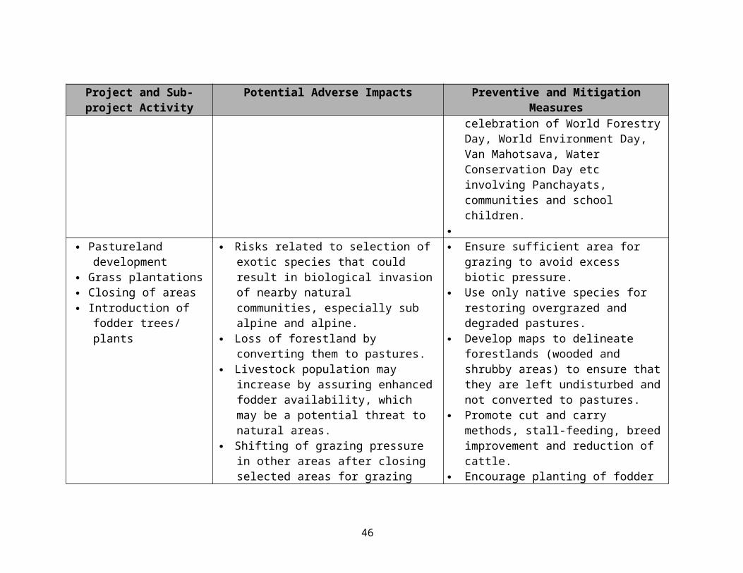
Project Phase Timeframe Specific Project Activity Tools Required Expected Outcomes Roles, Responsibilities
planning in high biodiversity areas bioindicators, visitor management, communications, awareness, documentation
ecosystem based approach, improved facilities, ESMF provisions
Categorization of sub-projects as E1, E2 and E3
Workshops List of sub-projects categorized across the two landscapes NTCA, PA Managers,
Ecologists, SociologistsESMF Provisions Apply
Two national level workshops with Ecologists, Sociologists and other relevant stakeholders to categorize the proposed investments and sub-projects into various categories depending on the degree of threat (adverse environmental impacts) posed by themDeveloping sub-project specific mitigation measures and EMP
Workshops Preventive and mitigation measures and EMP NTCA, PA Managers,
Ecologists, SociologistsESMF Provisions Apply
Once the investments and sub-projects have been categorized, location specific mitigation and preventive measures would be developed to address the adverse impacts and provisions would be designed to enhance the positive impacts; wherever required, an EMP would be prepared depending on the category of proposed investments/sub-projectsDevelopment of village level microplans including conservation and sustainable use livelihood strategies (for all stakeholders including indigenous and vulnerable people)
Consultative workshop, FGD, PRA, customizing GAAP provisions
Microplans with proposed livelihood strategies and ESMF provisions developed in transparent and participatory manner with GAAP provisions
PFT, NGOsESMF Provisions Apply
Screening of proposed investment/sub-projects (FORMAT 1 & 2 filled); Applying the ineligible projects filter; measures developed for implementing GAAP provisions in a transparent and participatory manner; detailing out the reciprocal commitments and community level participatory approaches
Impl
emen
tatio
n Ph
ase
Seco
nd to
sixt
h pr
ojec
t yea
r
Implementing the provisions of the village microplans, including livelihood activities
Training workshops, skill building, actual investments, livelihood strategies, M&E for GAAP provisions
Improved livelihoods, increased incomes, participatory conservation outcomes, sustainable use of local resources, NTFPs etc, undertaking community level initiatives for livelihoods and conservation
LBs, PFT, Landscape Societies
ESMF provisions, safeguards monitoring
PFT and Ecologists/Sociologists would closely monitor the implementation of ESMF provisions; project beneficiaries (stakeholders) would also undertake participatory monitoring for meeting the reciprocal commitments and also to monitor the livelihoods with conservation outcomes
Implementing the revised management Management plans, digitized Rationalization of park PA Managers, State
46

Project Phase Timeframe Specific Project Activity Tools Required Expected Outcomes Roles, Responsibilities
plans maps, social plans, habitat improvement
boundaries, better conservation planning, improved habitats and biodiversity Forest DepartmentESMF provisions Apply
Measures to enhance positive environmental gains would be implemented as well implementation of mitigation measures to contain adverse impacts would be ensured; PFT and contractual specialists (environment and social) would assist in monitoring, as well facilitate participatory monitoring of selected indicators
Third Party Mid-Term Review
Mid-Term Stage Independent Stakeholder Satisfaction SurveyIntegrating biodiversity conservation in production areas
Studies, small grants support, dialogue, MoU
Framework for cooperation in buffer areas, better and organized livelihoods in NTFP, sustainable timber, agriculture, fishing, grazing etc
Landscape Societies, State Government
Departments/Agencies, State Forest Department
Mainstreaming biodiversity conservation in regional development
Consensus building, stakeholder cooperation, ecosystem valuations, dialogue, meetings, workshops, studies
Clearer understanding of role of ecosystem goods and services in regional development
Improving participatory conservation and livelihood outcomes
Community decision making, PRA, microplan implementation, participatory monitoring
Socio-economic mapping, rights and resource dependencies, settlement of rights, PFT, NGO, LBs,
Landscape SocietiesESMF Provisions Apply
Preventive and mitigation measures, as provided in the ESMF would be implemented and oversight would be provided through participatory monitoring involving relevant stakeholders; in addition GAAP provisions and Grievance Redress mechanism would apply Valuation of Ecosystem Services in Conservation Landscapes
Stakeholder consultations, special studies
Valuation of ecosystem services, methodological framework for assessing ecosystem values
Landscape Societies
Capacity building and learning from demonstration landscapes
Cross visits (national), national level knowledge and information sharing workshops
Better PA management capacity at the NTCA, landscape and PA level
NTCA, PA Managers, Landscape Society, PFT,
Project Beneficiaries
Support to knowledge centers Awareness, documentation, Learning centers to improve NTCA, Landscape
47

Project Phase Timeframe Specific Project Activity Tools Required Expected Outcomes Roles, Responsibilities
training, capacity building, workshops, cross-visits
participatory conservation activities, disseminate knowledge and lessons, training material, field guides
Societies
Documentation and dissemination of practices in participatory conservations and extension of learning from national and international experiences
Documentation, website, publications, cross visits, participation in national and international events on conservation
Enhanced learning and dissemination of best practices NTCA, Landscape
Societies, NGOs, PA Managers
Enhancing knowledge for improved understanding of policy and legal issues
Special studies, workshops, Policy guidance notes Landscape Societies, NTCA, PA Managers
National Level Capacity Building for Promotion of Conservation Approaches
Participation in national and international seminars, workshops, cross tours, training, use of new technology
NTCA capacity development for replicating successful landscape conservation approaches in at least one additional landscape
NTCA
Scaling Up of Conservation Approaches in Additional landscapes Sites
Workshops, training, livelihood strategies, GIS mapping, management plans
Successful replications of livelihood and conservation approaches at landscape level
NTCA
Improving Coordination and Cost Effectiveness of Promotion of Landscape Conservation Approaches
M&E, workshops, dialogue and interdepartmental meetings
Capacity enhancement of MOEF and State Forest Departments, increased cooperation between various line departments and agencies within the landscape
MOEF, State Government Departments
Project End Independent Stakeholder Satisfaction Survey
Pre Planning PhasePlanning PhaseImplementation PhaseComponent 1 activitiesComponent 2 activitiesComponent 3 activitiesESMF Provisions would apply
48
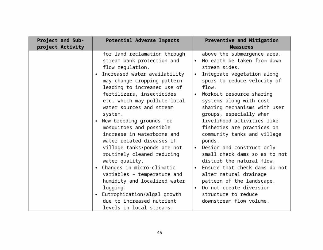
Negative list of projects
Subprojects with any of the attributes listed below will be ineligible for support under the proposed project.
Attributes of Ineligible Subprojects Any project activity with the potential for significant degradation of critical natural habitats,
including, but not limited to, any activity within declared Forest Reserves, Wildlife Reserves, National Parks and Sanctuaries.
Any project that is not consistent with Indian Forest Act and Wildlife Protection Act. Any project with the potential for significant damages to natural habitats. Any activity that has a significant potential of causing forest fires. Amy project or activity involving the procurement of pesticides not allowable under Bank
guidelines. Any activity that significantly affects the traditional and customary rights of the tribal and
transhumant population. Any large water harvesting structures or dams exceeding the height of 15 meters. Any project activity that leads to large-scale soil erosion and siltation. Any activity that promotes or involves incidence of child labor.
49
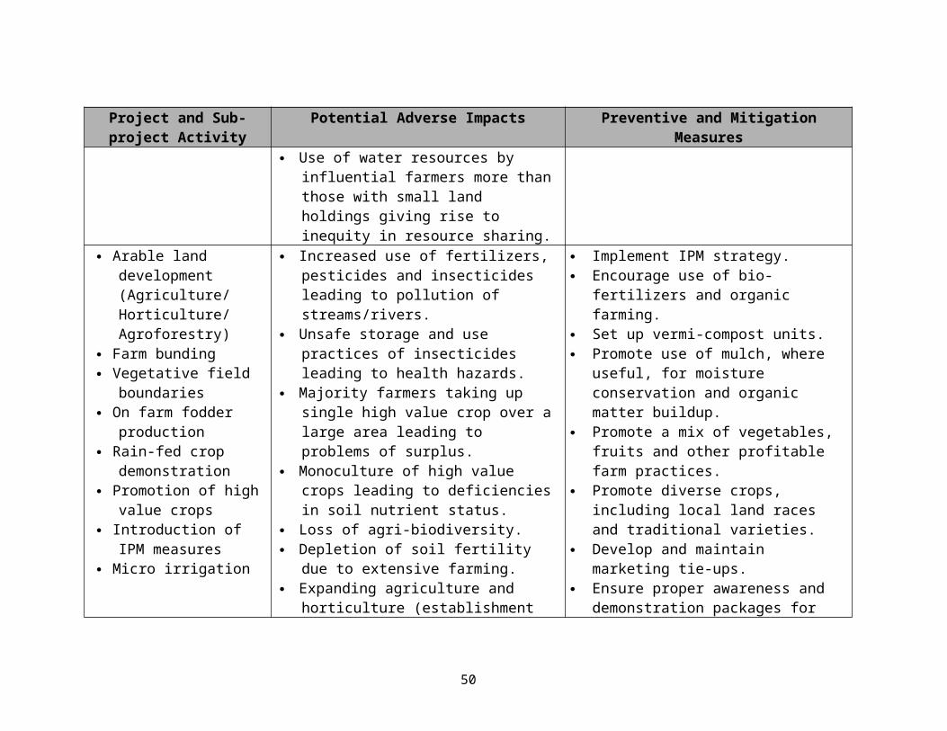
Chapter 8: Institutional Arrangement
1. Landscape approach requires coordinated support from various government institutions functioning in the area which goes beyond the responsibility of a single agency i.e. Wildlife Department. Foreseeing the needs of landscape management and recommendations of Tiger Task Force, GoI established the National Tiger Conservation Authority (NTCA). The state governments have proposed to either form autonomous Foundations or Societies for project management. Institutions both at National and State level will be responsible for their respective roles which is accountable vertically and horizontally to the society at large. However, services of skilled staff are a pre-requisite for quality and sustained services.
(a) National level – Broadly speaking the NTCA will play the role of a facilitator. This will require policy development which has national implications, disburse project funds and funds for relocation, coordinate learning, disseminate information on good practices through the communication unit and monitor and evaluate. While the selected sites for implementing the project are non-tiger reserves, it is expected that the learning from these approaches and the tools developed under the project would be useful at other sites, including the designated tiger reserves.
(b) State Level - State level institutional framework differs and reflects the requirements of each site. However, there are some common features at state level and consists of (i) institutional cell responsible for training program and compliance of Bank’s safeguard policies; (ii) communication unit will implement the strategy for continuous engagement with all stakeholders, disseminate information on site specific lessons learnt, prepare the IEC material, document good practices using electronic and print material, facilitate workshops, etc. (iii) Planning and Policy development will work towards bringing consistency across policies and legal framework applicable to the site, prepare annual plans, budgetary arrangements, (iv) Monitoring and evaluation will promote participatory monitoring and learning, carry out concurrent monitoring, collate the baseline information, mid-term and term evaluations. Multi-sectoral teams at division/district level will support the village level planning. Non-government organizations will function as implementing partners at the field. The District Administration will carry out regular review of the program.
(c) Grievance Redressal – A system to address grievances at village, district/division, state and national will be developed for immediate grievances (See Operational Manual for details).
(d) Independent reporting facilitated by MOEF(e) Since the implementing authorities (national, state and site level) has limited legal or
technical capacity to regularly review project investments and their associated impacts, environmental monitoring, inspections and audits, or management of mitigatory measures, the ESA has suggested specific components to strengthen that capacity that are detailed below in implementation arrangements and later in the chapter on monitoring and evaluation.
.
50

STATE LEVEL SOCIETY or FOUNDATION(Located in respective States)
PROJECT IMPLEMENTATION or FACILITATION UNITS(Located at the Landscape, Division or District Level)
PROJECT FACILITATION TEAMS or UNITS(Located in a cluster of villages level to provide direct facilitation support to the villages communities)
NATIONAL TIGER CONSERVATION AUTHORITY(Located in New Delhi)
PROJECT LEVEL
Forest Development Agencies
VSSs, EDCs, VFDCs, JFMCs, VPs, etc
Community Groups:User Groups, SHGs, CIGs, etc
COMMUNITY LEVEL
Figure 1 – ESMF Implementation Arrangement Framework and Responsibilities at the Project and Community Level
Environmental Categorization of Livelihood Activities
E1 Subprojects with minimal adverse environmental impacts and standard safeguards and/or pre-identified mitigation measures are sufficient to address impacts; requires routine monitoring by Nominated EO at Community Level; in addition PFT monitors 50% of E1 projects selected randomly for compliance with safeguards sheet
E2 Subprojects with moderate adverse environmental impacts and other than standard safeguards and/or pre-identified mitigation measures, some additional site-specific measures are required to address impacts; requires regular monitoring by PFT; in addition PIU reviews compliance status of 50% randomly selected projects
E3 Subprojects with substantial adverse environmental impacts; these would require a Rapid EIA and along with standard safeguards and/or pre-identified mitigation measures, additional site-specific measures, as recommended by the REIA would be required to address impacts; all subprojects (100%) requires complete monitoring by PFT and PIU and reported to Society; in addition NTCA reviews all E3 subprojects annually
Addl. Director, NTCA
Member-Secretary
Ecologist
2 Nominated Env Officer
2 Nominated Env Officer
51
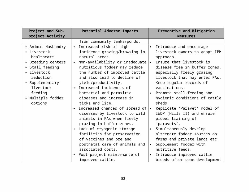
Flowchart Depicting Proposed Process for ESMF
Proposal(Developed by CG + PFT)
1st level screening by the trained nominated EO giving rough estimates regarding resources required, availability, access and impacts etc
PIU2nd level detailed screening done by Ecologist who also confirms Environmental Category
If E1, attaches safeguards sheet and PIU grants approval
M
& E
During implementation nominated EO undertakes routine monitoring; in addition PFT monitors 50% of E1 projects selected randomly for compliance with safeguards sheet
SocietyIf E2, attaches safeguards sheet and
recommends other site-specific measures and M
During implementation PFT undertakes regular monitoring; in addition PIU reviews
E1
E2
52

forwards to Society for review and approval (Society may add/ modify mitigation
measures)
& E
compliance status of 50% randomly selected projects
NTCAIf E3, proposal reaches NTCA, which
contracts a consultant for a Rapid EIA based on which approval is granted or proposal is
rejected; when approved would usually come with additional safeguards and mitigation
measures
M
& E
All subprojects (100%) requires complete monitoring by PFT and PIU and reported to Society; in addition NTCA reviews all E3 subprojects annually
Table 7 provides the State, Landscape and below level project governance structure and implementation arrangements.
E3
53

Table 7: Proposed State wise landscape and below level project governance structure and implementation arrangements:
S. No.
States Landscape Registered under Named as Governing Body –
Chairperson/President
Executive Committee – Chairperson/
President
Divisional/District Level Co-ordination and
Implementation Arrangements
Other Intermediate
Level Arrangements
Community Level
Arrangements
1 Gujurat Little Rann of Kutch
Societies Act, The BCRLIP Society
Minister for Forest
Principle Chief Conservator of Forest – Wildlife
Project Officer – DCF, Wildlife & Sanctuary
NGOs and other service providers
VDC, EDC, FPC, BMC…implementation through User Groups, CIGs, Producer Companies etc.,
2 Uttarakhand Askote Societies Act, The BCRLIP Society
Minister of Forest
Conservator Wildlife Circle – Almora
Two project management units located at Dharchulla & Munsiari
?? Van Panchyats
54

Chapter 9: Monitoring and Evaluation
1. A comprehensive monitoring strategy for environment and social development outcomes is being developed. This will be linked to the overall project monitoring and evaluation systems for project development objectives. More specifically the environment and social monitoring strategy will address institutional maturity in relation to participation, inclusiveness, transparency and equity; cause and effect of investments on livelihood that is based on conservation outcomes and environment and social safeguard framework. Monitoring by community and third party and thematic research will be parallel activities with mechanism for continuous feedbacks for learning and integrating with the training plan.
The monitoring framework would cover the indicators tools, samples, roles and responsibilities and mechanism for feedback. The broad questions which will need to be addressed are:
(a) Institutional maturity index
S. No. Objective Indicator
1. Participation Two adult members from every household in the village are members of village level institution
Growth of membership Attendance in meetings Quality of leadership Sharing of roles and responsibilities Selection of Executive Committee and representation of members representing user
groups Conflict resolution mechanism
2. Inclusiveness Women members Representation of women in the Executive Committee Representation of landless Representation of SC and STs
3. Ownership Maintenance of accounts. Contribution pattern Voluntary contribution Penalties on defaulter, Benefit charges Developed rules and regulation for management of transaction i.e. cost of investment
and contribution for benefits. 4. Transparency Information Sharing with members
Access to VCLP Information of roles and responsibilities of Executive Committee and bye-laws. Social audit for financial tracking in relation to assets created
5. Capacity Building User Groups have undergone minimum X trainings Executive committee (especially the representatives of user groups) have undergone
minimum X trainings
(b) Livelihood with conservation outcomes
55

S. No. Objective Indicator1. Increased number of
activities that are based on a sustainable framework
Increased number of beneficiaries taking up livelihood activities with conservation outcomes; for example, setting up of medicinal plant nurseries
People forming groups to ensure sustainable extraction of natural resources
2. Increased incomes coupled with sustainable use of natural resources and improvement in habitat quality
Number of beneficiaries taking up stall feeding and reducing scrub cattle
Linking employment generation under NREGA with habitat improvement activities, such as restoration of degraded pastures and grazing lands, development of fodder banks on community lands, drainage line treatment etc
3. Better return of investments
Increased access to nearby markets by developing market linkages and incorporating principles of supply chain management
Development of new markets for which skills and input resources are available but linkages missing
Promoting value addition of natural products instead of trading in natural resource based raw materials
4. Capacity Building At least X number of beneficiaries trained in new livelihood activities, such as, ecotourism, nature guide, adventure activities, horticulture practices etc
Stakeholders trained in accounting, business practices for small enterprises and for federating to negotiate for a better market price
(c) Social safeguard
S. No. Objective Indicator1. Conflict Management Legal awareness of rights and responsibilities
Endorsement of action plan by community to implement the provisions of Schedule Tribe and Forest dwellers Act
2. Equitable benefit sharing arrangement of NTFP and other resources.
Incentives for communities Policy interventions Rules of engagements
3. Relocation and resettlement
Endorsement of inviolate areas by communities Community demand driven relocation Community managed relocation and rehabilitation
(d) Environment safeguard
56

S. No. Objective Indicator1. Reduction in adverse
impacts on PA Reduction in scrub cattle Increase in stall feeding Reduction in firewood collection Area brought under afforestation/fodder bank
2. Biodiversity conservation
Changes in sighting and abundance of rare, vulnerable and endangered species
Number of medicinal plant nurseries set up Reduction in incidences of poaching Increase in population sizes of endangered/MAP species Area of degraded habitats restored Change in vegetation cover
3. Sustainable use of natural resources
Establishment of user groups for conservation and sustainable outcomes
Plan for sustainable extraction and use of natural resources
57

Chapter 10: Budget
The budget for implementation of ESMF is included as an integral part of the project, and will include support for communication strategy implementation, recruitment of sociologist, ecologist and social mobilizers, training of staff in management of social and environmental aspects, specific studies relating to environmental and social impact, piloting action plan for scheduled caste and forest dwellers act, legal and policy studies and environmental impact monitoring.
58