Embed Size (px)
Citation preview

remote sensing
Article
Evaluation and Improvement of SMOS and SMAPSoil Moisture Products for Soils with High OrganicMatter over a Forested Area in Northeast China
Mengjie Jin 1,2, Xingming Zheng 1,*, Tao Jiang 1, Xiaofeng Li 1, Xiaojie Li 1 and Kai Zhao 1
1 Northeast Institute of Geography and Agroecology, Chinese Academy of Sciences, Changchun 130102,China; [email protected] (M.J.); [email protected] (T.J.); [email protected] (X.L.);[email protected] (X.L.); [email protected] (K.Z.)
2 University of Chinese Academy of Sciences, Beijing 100049, China* Correspondence: [email protected]; Tel.: +86-431-8554-2224
Academic Editors: Gabriel Senay and Prasad S. ThenkabailReceived: 13 February 2017; Accepted: 15 April 2017; Published: 19 April 2017
Abstract: Soil moisture (SM) retrieval from SMOS (the Soil Moisture and Ocean Salinity mission)and SMAP (the Soil Moisture Active/Passive mission) passive microwave data over forestedareas with required accuracy is of great significance and poses some challenges. In this paper,we used Ground Wireless Sensor Network (GWSN) SM measurements from 9 September to5 November 2015 to validate SMOS and SMAP Level 3 (L3) SM products over forested areasin northeastern China. Our results found that neither SMOS nor SMAP L3 SM products wereideal, with respective RMSE (root mean square error) values of 0.31 cm3/cm3 and 0.17 cm3/cm3.Nevertheless, some improvements in SM retrieval might be achievable through refinements of thesoil dielectric model with respect to high percentage of soil organic matter (SOM) in the forestedarea. To that end, the potential of the semi-empirical soil dielectric model proposed by Jun Liu(Liu’s model) in improving SM retrieval results over forested areas was investigated. IntroducingLiu’s model into the retrieval algorithms of both SMOS and SMAP missions produced promisingresults. For SMAP, the RMSE of L3 SM products improved from 0.16 cm3/cm3 to 0.07 cm3/cm3 forAM (local solar time around 06:00 am) data, and from 0.17 cm3/cm3 to 0.05 cm3/cm3 for PM (localsolar time around 06:00 pm) data. For SMOS ascending orbit products, the accuracy was improvedby 56%, while descending orbit products improved by 45%.
Keywords: validation; soil moisture; organic matter; soil dielectric model; forest; northeast China
1. Introduction
Soil moisture (SM) is a vital variable in the global land surface water cycle and energy cycle.Accurate estimates of SM can be used to forecast and prevent floods and extreme drought events.In addition, SM estimation accuracy directly influences the reliability of numerical weather predictionsand hydrological models. Because forests make up one of the global primary land cover types,SM monitoring under forest cover has important implications for the study of hydrology, ecology,and climate change. Therefore, the acquisition of sufficiently accurate SM data for forest-coveredareas has become a pertinent subject. Several studies have reported that L-band passive microwaveradiometry is the most promising technique for monitoring SM in vegetated areas, due to its ability topenetrate the canopy cover and sensitivity to SM in all weather conditions [1–3]. The most commonlyused satellite-based sources of SM are the Soil Moisture and Ocean Salinity (SMOS) mission, launchedin 2009, and the Soil Moisture Active/Passive (SMAP) mission, launched in 2015. Both SMOS andSMAP are equipped with L-band sensors and aim to provide global near-surface SM (0–5 cm depth)products with an accuracy level of 0.04 cm3/cm3.
Remote Sens. 2017, 9, 387; doi:10.3390/rs9040387 www.mdpi.com/journal/remotesensing
Remote Sens. 2017, 9, 387 2 of 17
The direct measurement of passive microwave sensors is the brightness temperature TB, which isproportional to the emissivity (e) and surface physical temperature (T): (TB = e · T) [4]. Since a forestis a vertically layered system made up of canopy, trunks, understory, litter and soil, the emissionsfrom each layer and their interactions affect the measured TB. Therefore, SM retrieval under forestinvolves the process of removing the effects of vegetation, litter and roughness to obtain the reflectivityof the smooth bare soil surface. Soil permittivity which is related to the reflectivity is then computedfrom Fresnel formulations [5]. Finally, taking soil properties into account, the soil dielectric modelis applied to translate the soil permittivity into SM content. Therefore, the soil dielectric constantmodel is an essential component of the SM retrieval algorithms. The reliability of the soil dielectricconstant model directly impacts the precision of the retrieved SM values. It is well established that SMretrieval from passive microwave signals over forested areas is difficult [1,6–8] and efforts to obtainsufficient SM accuracy using SMOS/SMAP have not been very successful. For example, Rahmoune etal. compared SMOS level 2 (L2) SM products and ground measurements from the SCAN/SNOTELnetwork in the U.S. over forests and found that most RMSE (root mean square error) values rangedbetween 0.07 and 0.12 cm3/cm3 [7], which is far from satisfactory. It is still rare to see validation workfor SMAP SM products in forested areas. In order to improve the accuracy of satellite-derived SM,numerous studies have been devoted to calibrating the effects of vegetation [9,10], litter [11–13], androughness [14–17]. Here, we anticipate that some improvement in SM retrieval results may be possiblethrough refinements in the soil dielectric model with respect to the high percentage of soil organicmatter (SOM) in forest soil.
The alternative soil dielectric models for the SMOS and SMAP retrieval algorithms are Wang,Dobson, and Mironov [18,19]. These three models all consider soil as a four-phase (free water, boundwater, solids, and air) mixture and calculate the permittivity of the soil mixture by summing theweighted permittivity of each component according to its volumetric fraction. The Wang model [20]predicts and illustrates the different impacts of bound water from free water on soil permittivity.However, in this model, the permittivity of bound water is expressed by a linear combination of freewater and ice, without consideration of the substantial characteristics of bound water. The Dobsonmodel [21] retains the physical aspects of the dielectric properties of free water in the soil through theDebye equations, while not distinguishing the difference between free and bound water. The Mironovmodel [22] builds its expressions through a complex refractive index and calculates the dielectricproperties of bound water as well as free water using the Debye equations. With clay percentage asthe only soil input parameter, the Mironov model derives the needed spectroscopic parameters usinga set of regression equations based on large soil databases. These three models have been appliedin the SMOS and SMAP retrieval algorithms due to their simple parameterizations and applicabilityat L-band. The SMOS mission uses the land cover classification to choose the appropriate dielectricmodel (Wang, Dobson or Mironov), while the SMAP mission contains a switch in the processing stepsthat selects which dielectric model will be used in the SM retrieval [18,19].
SOM is one of the major components of some soil types, and numerous studies have established itsinfluence on soil dielectric properties. Organic-rich soil is usually characterized by high porosity levelsbecause SOM increases the proportion of air and decreases the bulk density. Furthermore, Malicki et al.suggested that the lower bulk density or higher porosity may lead to a lower permittivity of organicsoil than that of mineral soil with the same moisture content [23]. De Jong et al. demonstrated thatSOM would increase the fraction of bound water [24]. Also, because the relative permittivity of boundwater is smaller than that of free water [25], Bircher et al. attributed the lower permittivity of organicsoil than that of mineral soil at a given water content to the higher fraction of bound water in organicsoil [26]. Model simulation results also demonstrated the effects of SOM on soil dielectric properties.Mironov et al. used the generalized refractive mixing dielectric model (GRMDM) to compare thedielectric spectroscopic parameters of two agricultural soil samples that contained 6.6% and 0.6%of natural humus respectively [27]. The results of that comparison found that the L-band refractiveindex of the moist soil (~0.16 cm3/cm3) in the case of 6.6% humus was lower than that of the soil

Remote Sens. 2017, 9, 387 3 of 17
(~0.15 cm3/cm3) with 0.6% humus. These above results suggest that in the natural soil surface, SOMis a factor in the soil emissivity as the soil permittivity is indeed reduced by SOM.
However, there are few soil dielectric models that are suitable for organic-rich soil.The temperature-dependent multi-relaxation spectroscopic dielectric model (TD MRSDM) is oneexample of this kind of model, which was developed for thawed and frozen Arctic organic-rich soil(50% organic matter) by Mironov [28]. TD MRSDM is applicable in a frequency range of 0.05 to 15 GHzand temperature from −30 to 25 ◦C, and uses bulk density, gravimetric moisture, wave frequency,and temperature as input parameters. The accuracy of the dielectric model was evaluated using RMSE,and the respective values for the soil permittivity and the loss factor were 0.348 and 0.188. The modelerror is acceptable for practical simulation of the permittivity of thawed and frozen Arctic organic-richsoil. Nevertheless, TD MRSDM, which is entirely based on laboratory dielectric measurements fororganic-rich soil (50% organic matter), is not commonly applied in passive microwave SM retrievalalgorithms because natural soil may contain a wide variety of organic content. In order to include SOMas an independent variable in the soil dielectric model, Liu Jun et al. measured the dielectric constantsof 12 types of soil with organic matter content ranging from 0.03% to 17.84% using the coaxial probemethod and network analyzer (0.5 to 40 GHz) at room temperature (approx. 23 ◦C) [29]. Based ontheir experimental results, they evaluated the influence of organic matter on soil dielectric constantsand developed a semi-empirical dielectric model in which organic matter content was included asan input parameter to describe the dielectric behavior of soil with organic matter. Recently, Bircheret al. developed a simple empirical model for organic substrates [26], which gives out the L-bandrelative permittivity of organic soil as a function of water content. This empirical model considers asignificant variety of organic substrate types and agrees well with the TD MRSDM model. However,this empirical model similar as TD MRSDM is built on the soils that contain at least 50% organic matter.
The objective of this paper was not to continue calibrating the impacts of vegetation, roughness,and other influencing factors, but rather to investigate the potential of Liu’s model [29] in improvingSM retrieval results over forested areas. In Section 2, the general characteristics of the selectedstudy area is described. Section 3 provides details on the datasets used, the new semi-empirical soildielectric model (Liu’s model), and specific methods for this study. Section 4 compares the resultsof the SMOS/SMAP L3 SM product with in situ sensor network data and the improvements thatresulted from implementing the new soil dielectric model in the SM retrieval algorithms. Moreover,the accuracy influencing factors of satellite SM products and other possibilities for improvement arediscussed. In Section 5, conclusions are drawn.
2. Study Area
The in situ SM data for this study were obtained from Yichun (latitude 47–49◦N, longitude128–130◦E, and altitude 600 m), a 40 × 40 km intensive study area within the Tangwang Rivercatchment of Hei Longjiang Province in northeastern China (Figure 1). Yichun has a cold, temperateand humid climate with an average annual temperature of 1 ◦C and average annual rainfall of750 to 820 mm. Yichun is rich in a variety of forested resources, such as birch, larch, oak, and spruce,and 82.2% of the land cover is forest. In this forest area, there is a surface litter layer with a depth ofless than 3 cm, which is formed by mainly dead plant materials such as leaves, needles and twigs.Since humus beneath the litter layer of this area is very thin and usually too small to distinguish fromsoil by eyes, we treated it as a component of soil here. Topsoil in this paper refers to the 0–5 cm soil thatcalculated starting from the top of the layer without litter. Topsoil in this area is characterized by siltloam with a relatively high content of organic matter (approximately 25%). The detailed characteristicsof the soil samples collected from different in-situ SM sites (approximately 6 km apart from each other)within this study area are summarized in Table 1.

Remote Sens. 2017, 9, 387 4 of 17
Table 1. Topsoil information: soil type, sample numbers (SN) used in each site, textural fractions[%] of clay (<2 µm), silt (2–62.5 µm) and total sand (62.5–2000 µm) according to the FAO (Food andAgriculture Organization of the United Nations) soil texture classification [30].
Site Soil Type SN Clay Silt Sand
1 Silt Loam 25 14.21 66.48 19.312 Silt Loam 25 12.90 60.28 26.823 Silt Loam 25 12.37 67.66 19.974 Silt Loam 25 13.59 62.60 23.815 Silt Loam 20 12.32 69.01 18.676 Silt Loam 25 10.81 67.12 22.07
Remote Sens. 2017, 9, 387 4 of 17
Table 1. Topsoil information: soil type, sample numbers (SN) used in each site, textural fractions [%] of clay (<2 μm), silt (2–62.5 μm) and total sand (62.5–2000 μm) according to the FAO (Food and Agriculture Organization of the United Nations) soil texture classification [30].
Site Soil Type SN Clay Silt Sand 1 Silt Loam 25 14.21 66.48 19.31 2 Silt Loam 25 12.90 60.28 26.82 3 Silt Loam 25 12.37 67.66 19.97 4 Silt Loam 25 13.59 62.60 23.81 5 Silt Loam 20 12.32 69.01 18.67 6 Silt Loam 25 10.81 67.12 22.07
Figure 1. Land use types in the study area and locations of in situ SM stations.
3. Materials and Methods
3.1. Datasets
3.1.1. The Ground Wireless Sensor Network (GWSN) SM Measurements
The GWSN network collected hourly ground SM data from 9 September to 5 November 2015. These data were compared to SMOS and SMAP SM products to assess the performance of the SMOS and SMAP retrieval approaches. Direct comparison was not possible, however, due to the mismatch in spatial scale between the measurements provided by the satellite and in situ sensors [31]. To reduce the uncertainties introduced by scale differences between in situ points and satellite pixels, a high number of distributed sensors were laid out to accurately represent the satellite scale. As Figure 1 shows, the GWSN network was made up of a total of 17 Decagon EC-5 SM sensors that were approximately 10 km apart, distributed across two SMOS grids (Equal Area Scalable Earth [EASE] grid2, 25 km) and one SMAP grid (EASE grid2, 36 km). Of those 17 Decagon EC-5 sensors, 15 of them were located inside the SMAP grid (the grid center point longitude and latitude are 129.025°E and 48.157°N), seven were located inside the upper SMOS grid (the grid center point longitude and latitude are 129.035°E and 48.264°N), and five were inside the lower SMOS grid (the grid center point longitude and latitude are 129.035°E and 47.972°N). Moreover, to remove the influence of spatial variation in SM, the selected SMOS and SMAP grids were all relatively pure. The term “pure” for these grids refers to the following two aspects. On one hand, the soil characteristics for
Figure 1. Land use types in the study area and locations of in situ SM stations.
3. Materials and Methods
3.1. Datasets
3.1.1. The Ground Wireless Sensor Network (GWSN) SM Measurements
The GWSN network collected hourly ground SM data from 9 September to 5 November 2015.These data were compared to SMOS and SMAP SM products to assess the performance of the SMOSand SMAP retrieval approaches. Direct comparison was not possible, however, due to the mismatch inspatial scale between the measurements provided by the satellite and in situ sensors [31]. To reduce theuncertainties introduced by scale differences between in situ points and satellite pixels, a high numberof distributed sensors were laid out to accurately represent the satellite scale. As Figure 1 shows,the GWSN network was made up of a total of 17 Decagon EC-5 SM sensors that were approximately10 km apart, distributed across two SMOS grids (Equal Area Scalable Earth [EASE] grid2, 25 km) andone SMAP grid (EASE grid2, 36 km). Of those 17 Decagon EC-5 sensors, 15 of them were locatedinside the SMAP grid (the grid center point longitude and latitude are 129.025◦E and 48.157◦N),seven were located inside the upper SMOS grid (the grid center point longitude and latitude are129.035◦E and 48.264◦N), and five were inside the lower SMOS grid (the grid center point longitudeand latitude are 129.035◦E and 47.972◦N). Moreover, to remove the influence of spatial variation in SM,the selected SMOS and SMAP grids were all relatively pure. The term “pure” for these grids refersto the following two aspects. On one hand, the soil characteristics for the areas of these grids had

Remote Sens. 2017, 9, 387 5 of 17
good spatial consistency as summarized in Table 1. The average SOM for the 17 EC-5 SM sensor-siteswas 25% and was related to the soil bulk density in a negative linear fashion (Figure 2). On the otherhand, the predominant naturally occurring land cover type is forest, which reaches 95% and above inthe selected SMOS and SMAP grids. In this way, the selected SMOS and SMAP grids are consideredhomogeneous with respect to soil and land cover distribution, meaning that the mean SM values ofobservations from sensors at different locations are reasonable for representation at the satellite scale.
Another consideration was whether or not the in situ measurement network was reliable.The 17 Decagon EC-5 sensors were installed horizontally at 3 cm (the depth is calculated startingfrom the top of the layer without litter), with a measurement diameter approximately 5.5 cm. The EC-5sensor determines volumetric water content by measuring the dielectric constant of the media usingcapacitance/frequency (70 MHz) domain technology. The EC-5 sensor automatically applies factorycalibration functions [32] to convert voltage (mV) output to volumetric water content (θ, cm3/cm3).Factory calibration functions are applicable for most mineral soils with accuracy at least 0.03 cm3/cm3.However, site-specific calibration could not be neglected because the accuracy of those sensors may beinfluenced by the organic-rich soil. Bircher et al. considered this issue and calibrated both Decagon5TE sensor and Delta-T ThetaProbe ML2x sensor for natural organic soil [33]. Calibration functionsin [33] are presented in the form of θ = fct.(ε) for Decagon 5TE and θ = fct.(ε), θ = fct.(voltage) forDelta-T ThetaProbe. In this paper, the EC-5 sensors were also tested and calibrated in soils rangingfrom 10~55% of organic matter before being installed. The calibration results were obtained by linearlyfit ground truth sampling of SM values with EC-5 sensor measurements (Figure 3). The respectiveoverall accuracy of the original and calibrated EC-5 sensor were 0.04 cm3/cm3 and 0.01 cm3/cm3.
Remote Sens. 2017, 9, 387 5 of 17
the areas of these grids had good spatial consistency as summarized in Table 1. The average SOM for the 17 EC-5 SM sensor-sites was 25% and was related to the soil bulk density in a negative linear fashion (Figure 2). On the other hand, the predominant naturally occurring land cover type is forest, which reaches 95% and above in the selected SMOS and SMAP grids. In this way, the selected SMOS and SMAP grids are considered homogeneous with respect to soil and land cover distribution, meaning that the mean SM values of observations from sensors at different locations are reasonable for representation at the satellite scale.
Another consideration was whether or not the in situ measurement network was reliable. The 17 Decagon EC-5 sensors were installed horizontally at 3 cm (the depth is calculated starting from the top of the layer without litter), with a measurement diameter approximately 5.5 cm. The EC-5 sensor determines volumetric water content by measuring the dielectric constant of the media using capacitance/frequency (70 MHz) domain technology. The EC-5 sensor automatically applies factory calibration functions [32] to convert voltage (mV) output to volumetric water content (θ, cm3/cm3). Factory calibration functions are applicable for most mineral soils with accuracy at least 0.03 cm3/cm3. However, site-specific calibration could not be neglected because the accuracy of those sensors may be influenced by the organic-rich soil. Bircher et al. considered this issue and calibrated both Decagon 5TE sensor and Delta-T ThetaProbe ML2x sensor for natural organic soil [33]. Calibration functions in [33] are presented in the form of θ = fct.(ε) for Decagon 5TE and θ = fct.(ε), θ = fct.(voltage) for Delta-T ThetaProbe. In this paper, the EC-5 sensors were also tested and calibrated in soils ranging from 10~55% of organic matter before being installed. The calibration results were obtained by linearly fit ground truth sampling of SM values with EC-5 sensor measurements (Figure 3). The respective overall accuracy of the original and calibrated EC-5 sensor were 0.04 cm3/cm3 and 0.01 cm3/cm3.
0 10 20 30 40 50 600.0
0.1
0.2
0.3
0.4
0.5
0.6
0.7
0.8
Bul
k de
nsity
(g/c
m3 )
Soil organic matter content (%)
0.0109 0.695² 0.784
y x
R
= − +=
Figure 2. Soil organic matter content (SOM) and bulk density (g/cm3) of the soil samples from the 17 EC-5 SM sensor-sites.
0.16 0.18 0.20 0.22 0.24 0.26 0.28 0.30 0.32 0.34 0.36 0.380.16
0.18
0.20
0.22
0.24
0.26
0.28
0.30
0.32
0.34
0.36
0.38
y = 0.9522x + 0.0127 R2 = 0.8749
Original SM Measurements Calibrated SM Measurements
EC-5
Sen
sor
SM (c
m3 /c
m3 )
Ground Sampling SM (cm3/cm3) Figure 3. The calibration results of EC-5 SM sensor.
Figure 2. Soil organic matter content (SOM) and bulk density (g/cm3) of the soil samples from the17 EC-5 SM sensor-sites.
Remote Sens. 2017, 9, 387 5 of 17
the areas of these grids had good spatial consistency as summarized in Table 1. The average SOM for the 17 EC-5 SM sensor-sites was 25% and was related to the soil bulk density in a negative linear fashion (Figure 2). On the other hand, the predominant naturally occurring land cover type is forest, which reaches 95% and above in the selected SMOS and SMAP grids. In this way, the selected SMOS and SMAP grids are considered homogeneous with respect to soil and land cover distribution, meaning that the mean SM values of observations from sensors at different locations are reasonable for representation at the satellite scale.
Another consideration was whether or not the in situ measurement network was reliable. The 17 Decagon EC-5 sensors were installed horizontally at 3 cm (the depth is calculated starting from the top of the layer without litter), with a measurement diameter approximately 5.5 cm. The EC-5 sensor determines volumetric water content by measuring the dielectric constant of the media using capacitance/frequency (70 MHz) domain technology. The EC-5 sensor automatically applies factory calibration functions [32] to convert voltage (mV) output to volumetric water content (θ, cm3/cm3). Factory calibration functions are applicable for most mineral soils with accuracy at least 0.03 cm3/cm3. However, site-specific calibration could not be neglected because the accuracy of those sensors may be influenced by the organic-rich soil. Bircher et al. considered this issue and calibrated both Decagon 5TE sensor and Delta-T ThetaProbe ML2x sensor for natural organic soil [33]. Calibration functions in [33] are presented in the form of θ = fct.(ε) for Decagon 5TE and θ = fct.(ε), θ = fct.(voltage) for Delta-T ThetaProbe. In this paper, the EC-5 sensors were also tested and calibrated in soils ranging from 10~55% of organic matter before being installed. The calibration results were obtained by linearly fit ground truth sampling of SM values with EC-5 sensor measurements (Figure 3). The respective overall accuracy of the original and calibrated EC-5 sensor were 0.04 cm3/cm3 and 0.01 cm3/cm3.
0 10 20 30 40 50 600.0
0.1
0.2
0.3
0.4
0.5
0.6
0.7
0.8
Bul
k de
nsity
(g/c
m3 )
Soil organic matter content (%)
0.0109 0.695² 0.784
y x
R
= − +=
Figure 2. Soil organic matter content (SOM) and bulk density (g/cm3) of the soil samples from the 17 EC-5 SM sensor-sites.
0.16 0.18 0.20 0.22 0.24 0.26 0.28 0.30 0.32 0.34 0.36 0.380.16
0.18
0.20
0.22
0.24
0.26
0.28
0.30
0.32
0.34
0.36
0.38
y = 0.9522x + 0.0127 R2 = 0.8749
Original SM Measurements Calibrated SM Measurements
EC-5
Sen
sor
SM (c
m3 /c
m3 )
Ground Sampling SM (cm3/cm3) Figure 3. The calibration results of EC-5 SM sensor. Figure 3. The calibration results of EC-5 SM sensor.

Remote Sens. 2017, 9, 387 6 of 17
3.1.2. SMOS Data
The SMOS mission is in sun-synchronous orbit that ascends crossing the equator at 6 am anddescends crossing the equator at 6 pm. SMOS measurements are made over a range of incidenceangles (0 to 55◦) across a swath that is approximately 1000 km wide and with a spatial resolution of35 to 50 km. It takes three days to complete global measurements.
Since June 2011, SMOS has provided what are known as L3 data products in NetCDF format andprojected on the EASE grid version 2 with a spatial resolution of 25 km × 25 km [34]. The algorithmiccore of the L3 SM product is separate from the L2 SM processor, which is composed of a forwardmodel (L-MEB) and an iterative inversion procedure [35]. The L-MEB model simulates multi-angularand dual-polarized TB by quantifying the contributions of atmospheric interference, vegetation, andsurface roughness, as well as the contribution of the soil itself. SM is then iteratively calculated byminimizing the cost function, which is built on simulated and measured TB values. Note that theL-MEB model simulates the soil emissivity based on a dielectric mixing model (Dobson or Mironov)and the Fresnel equation. The difference between the daily L3 SM product and the L2 data is that theL3 SM product is processed based on the ESA L1B product. Moreover, the L3 processing algorithmuses a multi-orbit approach, in which calculations are done using three successive orbits within aseven-day moving window. When several values are available for a given day, the best estimation ofSM is selected for each grid point. For the SMOS L3 SM product, ascending and descending orbits areprocessed separately. In this paper, both the ascending and descending SMOS L3 SM daily productsfor the study area were used. The used L3 data were the last set of reprocessed data using the versionof the processor V3.00 at the time this work was conducted.
3.1.3. SMAP Data
Different from SMOS, SMAP only collects observations at an incidence angle of 40◦. Basedon a sun-synchronous orbit that ascends and descends the local overpass time at 6 pm and 6 am,respectively, SMAP produces global maps of passive soil moisture (0 to 5 cm) every two to three daysunder nested 9 and 36-km Earth grids.
The typical passive SM derivation approach proposed for SMAP is different from that proposedfor SMOS. Five algorithms (including SCA-H, SCA-V, DCA, E-DCA and LPRM) were suggested atthe initial release of the Algorithm Theoretical Basis Document (ATBD) [18]. Of these, the SingleChannel Algorithm-H polarization (SCA-H), Single Channel Algorithm-V polarization (SCA-V), andDual Channel Algorithm (DCA) are the most mature. Furthermore, SCA-V is the current baselinealgorithm for SM calculation using the SMAP radiometer. In the SCA-V approach, five steps are usedto extract SM from the measured TB: (1) TB in V polarization is proportionally converted to emissivity;(2) emissivity is corrected by removing the effects of vegetation; (3) emissivity is further corrected byaccounting for the effects of soil surface roughness; (4) the Fresnel equation is used to relate emissivityto the soil permittivity; and (5) a dielectric mixing model (Mironov) is used to relate the dielectricproperties to SM. This paper used the Version 4 SMAP L3 radiometer surface SM product, which is inHDF5 format and has the 36 km EASE-Grid 2.0 global projection.
3.1.4. Additional Data
For the purpose of validating the SMOS/SMAP L3 SM products and Liu’s model, we downloadedadditional data for the study area within the study time period from 9 September to 5 November2015: (1) precipitation data from Yichun station (ID 50774) provided by NOAA’s NCEI (NOAA isshort for National Oceanic and Atmospheric Adminstration and NCEI is short for National Centers forEnvironmental Information); and (2) a 30-m Global Land Cover Dataset. This dataset is supported bythe National High Technology Research and Development Program of China. In this paper, the GlobalLand Cover Dataset provides a reference for the selection of the study area.

Remote Sens. 2017, 9, 387 7 of 17
3.2. Methodology
3.2.1. Methodology for Comparison
A robust validation of retrieved SM products can be useful for reevaluating and adjusting thealgorithms used in the data processing steps. With the expectation of the fact that the two missions(SMOS and SMAP) can produce more accurate data products over forested areas, the retrieved SMOSand SMAP SM products were first compared directly with the in situ SM data for forested areas innortheastern China. Because the selected SMOS and SMAP grids in which the in situ SM sensor siteswere distributed are homogeneous (as described in Section 3.1.1), a simple drop-in-bucket type ofapproach was used for the SMOS and SMAP grids. In a first step, all the observations from SMOS andSMAP that are RFI (radio frequencies interferences) and open water flagged are filtered out. The daily06:00 am and 06:00 pm variations (including minimum, maximum, and mean values) of the in situSM observations from the 15 ground sensors that were located in the SMAP grid were compared withL3 SMAP AM (local solar time around 06:00 am) and PM (local solar time around 06:00 pm) datarespectively for the time period between 9 September and 5 November 2015. For SMOS validation,only the upper SMOS grid was selected because it had better sensor coverage (seven in total), as seenin Figure 1. Meanwhile, the five sensors located within the lower SMOS grid lacked spatial variation,as they were clustered in the top half of that grid. The daily 6 am and 6 pm SM values (includingminimum, maximum, and mean values) from the seven sensors distributed within the upper SMOSgrid were compared with the L3 SMOS AM and PM data respectively to evaluate the SMOS algorithm.To assess the performance of SMOS/SMAP SM retrievals and Liu’s model, statistics such as bias(B), root mean square error (RMSE), unbiased root mean square error (ubRMSE), and the Pearsoncorrelation coefficient (R) with 95% confidence intervals were used to quantify the differences andrelationships between SMOS/SMAP SM products and SM ground measurements from the GWSN.The ubRMSE was calculated as a function of the bias and the RMSE [36]:
B =n
∑i=1
(SMSMOS/SMAP − SMGWSN
n
)(1)
RMSE =
√∑n
i=1(SMSMOS/SMAP − SMGWSN)2
n− 1(2)
ubRMSE =√
RMSE2−B2 (3)
where n is the total number of SM retrievals considered in the comparison.
3.2.2. Methodology for Obtaining Revised Satellite SM
In order to investigate the potential of Liu’s model in improving SM retrieving accuracy,it was added to the processing steps of both SMOS and SMAP in place of their original alternativesoil permittivity models (Dobson or Mironov). The methods and parameters that dealt withsurface roughness, vegetation effects, and other influencing factors in the SMOS and SMAPinversion algorithms remained unchanged. Revised SM values were again compared to the groundmeasurements to see whether refinement of the soil dielectric model for organic matter rich soilsimproved the outcome. The general approach that was used to obtain revised satellite-derived SMvalues was the following:
(1) Obtain the key parameters of the L-MEB model, such as canopy parameters optical depth (τNAD)and albedo (ω), land surface temperature parameter TS, and the four soil roughness parametersQR , HR and NRP (p = H or V) of the model employed by Marie Parrens et al. [15]. For SMOS,τNAD and TS were obtained from the SMOS L3 daily SM products, and ω and HR were assumedto be constant as described in [6], with ω = 0.07 and HR = 1.2. For SMAP, the values of τNAD, ω,

Remote Sens. 2017, 9, 387 8 of 17
TS, and HR were obtained from the SMAP L3 daily SM products. Here, we assumed that NRP = 0(p = H or V) for both SMOS and SMAP. QR was also approximated to zero as had been done inthe SMOS and SMAP retrieval algorithms, since QR was low at L-band [17,37,38].
(2) Run Liu’s model instead of the Mironov model within the L-MEB model to obtain new expressionsfor TB_Sim for SMOS and SMAP, based on their own L-MEB model parameters.
(3) Minimize the cost function CF (Equation (4)) by a generalized least squares iterative algorithmto achieve the revised SM values. For both SMOS and SMAP, the initial value for SM fromthe inversion process was the corresponding satellite SM product value. TB_Obs was thecorresponding satellite observed brightness temperature value, which was obtained from theSMOS (incident angle approximately 42.5◦) and SMAP (incident angle approximately 40◦) L3daily SM products.
CF =p=H,V
∑p
( TB_Sim(p)− TB_Obs(p))2 (4)
3.2.3. Liu’s Model
Liu’s model [29] is built on the basis of the Mironov model and has two variables (the boundwater content mvt and the dielectric properties of solid soil particles εs) improved by organic mattercontent. The detailed expressions of this semi-empirical model are as follows [29]:
√εm =
{ √εd + (
√εd − 1) ·mv mv ≤ mvt
√εd + (
√εb − 1) ·mvt + (
√εu − 1) · (mv −mvt) mv ≥ mvt
(5)
where ε is the relative complex permittivity, mvt (cm3/cm3) is the bound water content and mv is thevolumetric water content. The subscripts m, d, b and u denote “soil mixture”, “dry soil”, “bound water”and “free water”, respectively.
mvt is the point at which water switches from bound to free state. Humus, as the main componentof SOM, is a hydrophilic substance and has a strong ability to absorb water. Therefore, soil with higherorganic matters also contains a high proportion of bound water. The impact of SOM on the boundwater content is expressed by:
mvt = 0.02982 + 0.01068 ∗ SOM + 0.00089 ∗ CLAY (6)
where SOM and CLAY are the mass percentages of soil organic matter and clay, respectively. SOM willalso change the soil structure, reduce soil bulk density, and increase porosity, thereby increasing theproportion of air and reducing the soil permittivity when under a certain content of water. Thus, the rawdensity of the solid soil particles ρs (g/cm3) is different than that of mineral soil and is determined bySOM:
ρs =mmineral + morganic
vmineral + vorganic=
ρmineral ∗ ρorganic
(1− SOM) ∗ ρorganic + SOM ∗ ρmineral(7)
where mmineral and morganic are the quality of mineral soil particle and organic matter respectively.vmineral and vorganic are the volume of mineral soil particle and organic matter respectively.ρmineral = 2.65 g/cm3 is the density of a mineral soil particle and ρorganic = 1.5 g/cm3 is the density oforganic matter. The subscript s denotes “solid soil particles”.
Based on Equation (5), the relationship between the dielectric properties of solid soil particles andthose of dry soil are described by the following equation:
√εd = 1 + (
√εs − 1) ∗ ρb
ρs(8)

Remote Sens. 2017, 9, 387 9 of 17
According to the dielectric properties measurement results of 12 types of dry soil and Equation (8),the permittivity for solid soil particles and its relationship to organic matter content can finally bedetermined by the following empirical formula:
εs = 0.1469 ∗ SOM + 4.983 (9)
Equation (9) only calculates the real part of the permittivity of solid soil particles as a functionof SOM and does not improve the imaginary part. The dielectric constants for bound water and freewater are determined by the Debye formulas as in [22].
4. Results and Discussion
4.1. Comparison of SMOS/SMAP L3 Data with In-Situ Measurements
SMOS L3 data for the EASE grid2 (129.035◦E and 48.264◦N) were compared to the SM valuesthat were measured continuously by the seven ground sensors throughout the focus areas (Figure 4a).SM was clearly underestimated by SMOS. From the period of 9 September to 5 November 2015,the daily mean SM value was 0.37 cm3/cm3 for the ground sensors, while SMOS AM resultsaveraged 0.07 cm3/cm3 and PM averaged 0.08 cm3/cm3. These low SMOS SM values (below0.1 cm3/cm3) seemed unreasonable for the Yichun area, which has a cold, temperate and humidclimate. The total rainfall during the study period was 92 mm. Figure 4b shows SMAP L3 SM valuesfor the grid (129.0249◦E and 48.1572◦N) as compared with the average values from the 15 in-situsensors, and reveals that the SMAP product also underestimated SM. The SMAP SM values werecloser to the ground measurements than SMOS, with a daily AM mean value of 0.28 cm3/cm3 and PMmean value of 0.26 cm3/cm3 for the study period. To quantitatively evaluate the SMOS and SMAPL3 products, statistics (Bias, RMSE, ubRMSE, R) on the comparisons between satellite retrievals andin-situ measurements were summarized in Table 2. This showed that there was a slight difference inthe quality of the ascending (RMSE = 0.30 cm3/cm3) and descending (RMSE = 0.31 cm3/cm3) SMOSL3 SM daily products. The RMSE value of AM and PM SMAP SM product was 0.16 cm3/cm3 and0.17 cm3/cm3 respectively, which were superior to that of SMOS. In general, neither SMOS nor SMAPmeet the missions’ accuracy requirements for SM retrievals (0.04 cm3/cm3) over this forested area.
The in-situ SM data corresponded well with rainfall, showing an increasing trend during rainfallevents and a decreasing trend after rainfall events (Figure 4). SMOS and SMAP data, on the otherhand, did not seem to be able to capture the rainfall events as well as the in-situ data. For example,the top plot of Figure 4b shows an anomalous decreasing trend in the SMAP daily AM data during arainy time period from DOY (Day Of Year) 281 to 284. This phenomenon is not easy to understand,because emissivity values usually decrease and canopy opacity increases following rainfall events [39],which should result in an overestimation bias in the SM calculations [40]. Figure 4a also shows thatthe SMOS L3 SM data were not temporally continuous. One of the reasons for this is that the SMOSrevisit period is three days at the equator, which means it takes approximately three days to cover theglobal surface from the SMOS field of view. Another reason is that the SMOS SM data were maskedout if the Data Quality Index (DQX) was larger than 0.06, or equal to 0.

Remote Sens. 2017, 9, 387 10 of 17Remote Sens. 2017, 9, 387 10 of 17
250 260 270 280 290 300 3100.000.050.100.150.200.250.300.350.400.450.50
250 260 270 280 290 300 3100.00
0.05
0.10
0.15
0.20
0.25
0.30
0.35
0.40
0.45
0.50
250 260 270 280 290 300 3100.15
0.20
0.25
0.30
0.35
0.40
0.45
0.50
0.55
250 260 270 280 290 300 3100.15
0.20
0.25
0.30
0.35
0.40
0.45
0.50
0.55
SM (c
m3 /c
m3 )
GWSN_AM_Average SMOS_AM
(a)SM
(cm
3 /cm
3 )
GWSN_PM_Average SMOS_PM
250 260 270 280 290 300 3100
2
4
6
8
10
12
14
16
18
Rai
nfal
l (m
m)
DOY
Rainfall
(b)
SM (c
m3 /c
m3 )
GWSN_AM_Average SMAP_AM
SM (c
m3 /c
m3 )
GWSN_PM_Average SMAP_PM
250 260 270 280 290 300 3100
2
4
6
8
10
12
14
16
18
Rai
nfal
l (m
m)
DOY
Rainfall
Figure 4. Comparisons between Ground Wireless Sensor Network (GWSN) measurements with Soil Moisture and Ocean Salinity (SMOS) (a) and Soil Moisture Active/Passive (SMAP) (b) Soil Moisture (SM) products. GWSN_AM_Average and GWSN_PM_Average indicate the average values of the sensors located in the corresponding SMOS and SMAP grids at the time of 6 a.m. and 6 p.m. respectively. The shaded area corresponds to the interval between the minimum and maximum values of GWSN measurements. For the SMOS grid, the range of GWSN measurements is 0.30–0.43 cm3/cm3, the standard deviation is 0.03 cm3/cm3, and for the SMAP grid, the range and standard deviation of GWSN measurements are 0.36–0.47 cm3/cm3 and 0.03 cm3/cm3.
4.2. Liu’s Model Performance
In general, the retrieved SM values from both missions were underestimated and were far from the accuracy requirements of 0.04 cm3/cm3. Given the fact that forested areas have high SOM content in the upper layer and that SOM substantially changes soil structure and water holding capacity, we expect that the dielectric model could be improved by including organic matter content as an independent variable. Figure 5 shows the comparison between the permittivity simulated by the Mironov model and Liu’s model for three kinds of soil with the same clay content (13%) and different SOM content (10%, 20% and 30%) at 1.4 GHz. When SM is 0.35 cm3/cm3 and SOM is 30%, the real part of simulated permittivity by Liu’s model is 15.81. For the Mironov model, which neglects the organic matter impact, the real part of simulated permittivity is much higher, with a value of 21.95. For the imaginary part, the difference was not so dramatic: ε” = 2.02 for Liu’s model and ε” = 2.96 for the Mironov model. The simulation results from Liu’s model for soil with SOM ranging from 10% to 30% also revealed that as SOM increases, the permittivity decreases.
Figure 4. Comparisons between Ground Wireless Sensor Network (GWSN) measurements withSoil Moisture and Ocean Salinity (SMOS) (a) and Soil Moisture Active/Passive (SMAP) (b) SoilMoisture (SM) products. GWSN_AM_Average and GWSN_PM_Average indicate the average valuesof the sensors located in the corresponding SMOS and SMAP grids at the time of 6 am and 6 pm,respectively. The shaded area corresponds to the interval between the minimum and maximum valuesof GWSN measurements. For the SMOS grid, the range of GWSN measurements is 0.30–0.43 cm3/cm3,the standard deviation is 0.03 cm3/cm3, and for the SMAP grid, the range and standard deviation ofGWSN measurements are 0.36–0.47 cm3/cm3 and 0.03 cm3/cm3.
4.2. Liu’s Model Performance
In general, the retrieved SM values from both missions were underestimated and were far fromthe accuracy requirements of 0.04 cm3/cm3. Given the fact that forested areas have high SOM contentin the upper layer and that SOM substantially changes soil structure and water holding capacity,we expect that the dielectric model could be improved by including organic matter content as anindependent variable. Figure 5 shows the comparison between the permittivity simulated by theMironov model and Liu’s model for three kinds of soil with the same clay content (13%) and differentSOM content (10%, 20% and 30%) at 1.4 GHz. When SM is 0.35 cm3/cm3 and SOM is 30%, the realpart of simulated permittivity by Liu’s model is 15.81. For the Mironov model, which neglects theorganic matter impact, the real part of simulated permittivity is much higher, with a value of 21.95.For the imaginary part, the difference was not so dramatic: ε” = 2.02 for Liu’s model and ε” = 2.96 forthe Mironov model. The simulation results from Liu’s model for soil with SOM ranging from 10% to30% also revealed that as SOM increases, the permittivity decreases.

Remote Sens. 2017, 9, 387 11 of 17
Remote Sens. 2017, 9, 387 11 of 17
0.0 0.1 0.2 0.3 0.4 0.5 0.6
0
10
20
30
40
50
0.0 0.1 0.2 0.3 0.4 0.5 0.6012345678
Perm
ittiv
ity (ε
’)Pe
rmitt
ivity
(ε'')
SM (m3/m3)
Mironov model Liu’s model SOM=10% Liu’s model SOM=20% Liu’s model SOM=30%
Figure 5. Comparison between the dielectric constants simulated by the Mironov model and that simulated by Liu’s model for three kinds of soil with the same clay content (13%) and different SOM (10%, 20% and 30%) at 1.4 GHz.
Figures 6 and 7 and Table 2 display the overall performance of Liu’s model. Our analysis indicated clear improvements through modification of the soil dielectric model. The bias between the in-situ SM and the revised retrieval values from SMOS in ascending orbit was 0.08 cm3/cm3, with a RMSE of 0.13 cm3/cm3. Although these results still do not meet the accuracy requirement of 0.04 cm3/cm3, it is much better compared with the original SMOS SM products, which had a bias of 0.29 cm3/cm3 and a RMSE of 0.30 cm3/cm3. For the descending SMOS orbit, the level of underestimation was also attenuated and the accuracy was improved by approximately 45%. The revised retrieval values from SMAP were much closer to the ground measurements with a satisfactory RMSE of 0.05 cm3/cm3 for PM data. Moreover, the correlation coefficients between the revised retrievals and ground measurements were improved more or less. Consequently, we can conclude that the new semi-empirical soil dielectric model is a reasonable improvement with regard to organic soil and can be applied to forested areas to obtain higher quality estimates of SM.
Table 2. The overall statistics of SM retrievals compared with the average values of GWSN SM for the corresponding SMOS and SMAP grids.
Statistical Indicators
Satellite SM Retrievals with Mironov Model
Revised SM Retrievals with Liu’s Model
SMOS
AM SMOS
PM SMAP
AM SMAP
PM SMOS
AM SMOS
PM SMAP
AM SMAP
PM Bias 0.29 0.29 0.15 0.16 0.08 0.14 0.02 0.02
RMSE 0.30 0.31 0.16 0.17 0.13 0.17 0.07 0.05 ubRMSE 0.10 0.10 0.05 0.05 0.10 0.08 0.06 0.05
R 0.25 0.11 0.24 0.24 0.29 0.31 0.24 0.55
Figure 5. Comparison between the dielectric constants simulated by the Mironov model and thatsimulated by Liu’s model for three kinds of soil with the same clay content (13%) and different SOM(10%, 20% and 30%) at 1.4 GHz.
Figures 6 and 7 and Table 2 display the overall performance of Liu’s model. Our analysis indicatedclear improvements through modification of the soil dielectric model. The bias between the in-situSM and the revised retrieval values from SMOS in ascending orbit was 0.08 cm3/cm3, with a RMSEof 0.13 cm3/cm3. Although these results still do not meet the accuracy requirement of 0.04 cm3/cm3,it is much better compared with the original SMOS SM products, which had a bias of 0.29 cm3/cm3
and a RMSE of 0.30 cm3/cm3. For the descending SMOS orbit, the level of underestimation was alsoattenuated and the accuracy was improved by approximately 45%. The revised retrieval values fromSMAP were much closer to the ground measurements with a satisfactory RMSE of 0.05 cm3/cm3 for PMdata. Moreover, the correlation coefficients between the revised retrievals and ground measurementswere improved more or less. Consequently, we can conclude that the new semi-empirical soil dielectricmodel is a reasonable improvement with regard to organic soil and can be applied to forested areas toobtain higher quality estimates of SM.
Table 2. The overall statistics of SM retrievals compared with the average values of GWSN SM for thecorresponding SMOS and SMAP grids.
StatisticalIndicators
Satellite SM Retrievals withMironov Model
Revised SM Retrievals withLiu’s Model
SMOSAM
SMOSPM
SMAPAM
SMAPPM
SMOSAM
SMOSPM
SMAPAM
SMAPPM
Bias 0.29 0.29 0.15 0.16 0.08 0.14 0.02 0.02RMSE 0.30 0.31 0.16 0.17 0.13 0.17 0.07 0.05
ubRMSE 0.10 0.10 0.05 0.05 0.10 0.08 0.06 0.05R 0.25 0.11 0.24 0.24 0.29 0.31 0.24 0.55

Remote Sens. 2017, 9, 387 12 of 17Remote Sens. 2017, 9, 387 12 of 17
250 260 270 280 290 300 310
0.000.050.100.150.200.250.300.350.400.450.50
250 260 270 280 290 300 3100.00
0.05
0.10
0.15
0.20
0.25
0.30
0.35
0.40
0.45
0.50
0.00 0.05 0.10 0.15 0.20 0.25 0.30 0.35 0.40 0.450.00
0.05
0.10
0.15
0.20
0.25
0.30
0.35
0.40
0.45
0.00 0.05 0.10 0.15 0.20 0.25 0.30 0.35 0.40 0.450.00
0.05
0.10
0.15
0.20
0.25
0.30
0.35
0.40
0.45
SM (c
m3 /c
m3 )
DOY
GWSN_AM_Average SMOS_AM Revised SMOS_AM
SM (c
m3 /c
m3 )
DOY
GWSN_PM_Average SMOS_PM Revised SMOS_PM
SMOS_AM (R=0.25) Revised SMOS_AM (R=0.29)Line : y=x
SMO
S (c
m3 /c
m3 )
GWSN_AM_Average (cm3/cm3)
SMOS_PM (R=0.11) Revised SMOS_PM (R=0.31)Line : y=x
SMO
S (c
m3 /c
m3 )
GWSN_PM_Average (cm3/cm3) Figure 6. Comparisons of revised SMOS SM by Liu’s model with SMOS L3 SM products.
250 260 270 280 290 300 3100.15
0.20
0.25
0.30
0.35
0.40
0.45
0.50
0.55
250 260 270 280 290 300 3100.15
0.20
0.25
0.30
0.35
0.40
0.45
0.50
0.55
0.15 0.20 0.25 0.30 0.35 0.40 0.45 0.50 0.550.15
0.20
0.25
0.30
0.35
0.40
0.45
0.50
0.55
0.15 0.20 0.25 0.30 0.35 0.40 0.45 0.50 0.550.15
0.20
0.25
0.30
0.35
0.40
0.45
0.50
0.55
GWSN_AM_Average SMAP_AM Revised SMAP_AM
SM (c
m3 /c
m3 )
DOY
SM (c
m3 /c
m3 )
DOY
GWSN_PM_Average SMAP_PM Revised SMAP_PM
SMAP_AM (R=0.24) Revised SMAP_AM (R=0.30) Line: y=x
SMA
P (c
m3 /c
m3 )
GWSN_AM_Average (cm3/cm3)
SMAP_PM (R=0.24) Revised SMAP_PM (R=0.55) Line: y=x
SMA
P (c
m3 /c
m3 )
GWSN_PM_Average (cm3/cm3) Figure 7. Comparisons of revised SMAP SM by Liu’s model with SMAP L3 SM products.
Figure 6. Comparisons of revised SMOS SM by Liu’s model with SMOS L3 SM products.
Remote Sens. 2017, 9, 387 12 of 17
250 260 270 280 290 300 310
0.000.050.100.150.200.250.300.350.400.450.50
250 260 270 280 290 300 3100.00
0.05
0.10
0.15
0.20
0.25
0.30
0.35
0.40
0.45
0.50
0.00 0.05 0.10 0.15 0.20 0.25 0.30 0.35 0.40 0.450.00
0.05
0.10
0.15
0.20
0.25
0.30
0.35
0.40
0.45
0.00 0.05 0.10 0.15 0.20 0.25 0.30 0.35 0.40 0.450.00
0.05
0.10
0.15
0.20
0.25
0.30
0.35
0.40
0.45
SM (c
m3 /c
m3 )
DOY
GWSN_AM_Average SMOS_AM Revised SMOS_AM
SM (c
m3 /c
m3 )
DOY
GWSN_PM_Average SMOS_PM Revised SMOS_PM
SMOS_AM (R=0.25) Revised SMOS_AM (R=0.29)Line : y=x
SMO
S (c
m3 /c
m3 )
GWSN_AM_Average (cm3/cm3)
SMOS_PM (R=0.11) Revised SMOS_PM (R=0.31)Line : y=x
SMO
S (c
m3 /c
m3 )
GWSN_PM_Average (cm3/cm3) Figure 6. Comparisons of revised SMOS SM by Liu’s model with SMOS L3 SM products.
250 260 270 280 290 300 3100.15
0.20
0.25
0.30
0.35
0.40
0.45
0.50
0.55
250 260 270 280 290 300 3100.15
0.20
0.25
0.30
0.35
0.40
0.45
0.50
0.55
0.15 0.20 0.25 0.30 0.35 0.40 0.45 0.50 0.550.15
0.20
0.25
0.30
0.35
0.40
0.45
0.50
0.55
0.15 0.20 0.25 0.30 0.35 0.40 0.45 0.50 0.550.15
0.20
0.25
0.30
0.35
0.40
0.45
0.50
0.55
GWSN_AM_Average SMAP_AM Revised SMAP_AM
SM (c
m3 /c
m3 )
DOY
SM (c
m3 /c
m3 )
DOY
GWSN_PM_Average SMAP_PM Revised SMAP_PM
SMAP_AM (R=0.24) Revised SMAP_AM (R=0.30) Line: y=x
SMA
P (c
m3 /c
m3 )
GWSN_AM_Average (cm3/cm3)
SMAP_PM (R=0.24) Revised SMAP_PM (R=0.55) Line: y=x
SMA
P (c
m3 /c
m3 )
GWSN_PM_Average (cm3/cm3) Figure 7. Comparisons of revised SMAP SM by Liu’s model with SMAP L3 SM products. Figure 7. Comparisons of revised SMAP SM by Liu’s model with SMAP L3 SM products.

Remote Sens. 2017, 9, 387 13 of 17
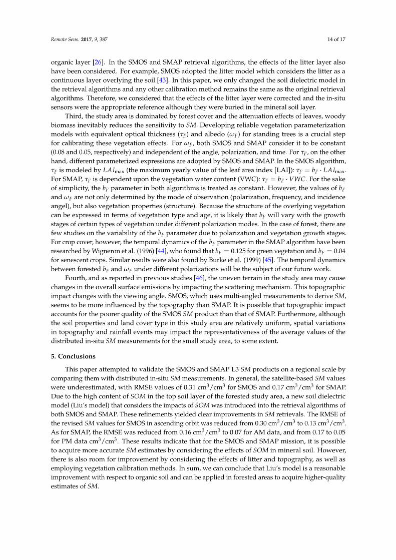
4.3. Discussion
Based on the comparison between the SMOS and SMAP L3 SM products and the in-situmeasurement network over the forested study area, it was found that the satellite-derived SM valueswere underestimated, with RMSE values of 0.31 m3·m−3 for SMOS and 0.17 m3·m−3 for SMAP. Severalaspects may account for the discrepancy between the retrieved SM values and ground measurements.First, the current soil dielectric model, the Mironov model, that is typically applied in the retrievalalgorithms neglects the impacts of SOM. Figure 2 shows a strong negative linear correlation betweenSOM and soil bulk density (BD, g/cm3): BD = −0.0109 · SOM + 0.695 (R2 = 0.784). This meansthat SOM content greatly decreases the bulk density through changes in the soil structure (such asporosity). Moreover, SOM can increase the fraction of the bound water content of soil. As a result,the dielectric constants of organic soil will be lower than that of mineral soil with the same SM content.Because of this, a higher TB value observed by the passive sensors would be converted into driersoil conditions if SOM were neglected in the retrieval algorithm. In this paper, we accounted for thisinfluence by introducing Liu’s model into the SM retrieval algorithms, which clearly improved theresults (Section 4.2). The differences between SM values calculated using Liu’s model (SM1) and theMironov model (SM2) were further examined and analyzed in Figure 8. It is clear that as SM1 andSOM increased, so did the discrepancy between SM1 and SM2. This means that the wetter the soiland the higher the SOM content, the more the SOM affects the accuracy of the satellite-derived SMvalues. However, it must be stressed that Liu’s model has its own limitations and errors. For example,Liu’s model calculates the real part of the permittivity of solid soil particles as a function of SOM basedon experimental data; however, the influence of SOM on the imaginary part of the permittivity of solidsoil particles is not considered. On the other hand, the Debye equation parameters for free and boundwater that are adopted by Liu’s model are also probably affected by SOM and could lead to predictionerrors [29]. Additionally, the range of the GWSN measurements in this paper is 0.30–0.47 cm3/cm3
with a standard deviation of 0.03 cm3/cm3. This relatively low dynamics is due to the local climate ofthe study area. Therefore, the fitness and reliability of Liu’s model in improving satellite-based SMretrievals need to be validated on a larger spatial and temporal scale over the entire wetness range.
Remote Sens. 2017, 9, 387 13 of 17
4.3. Discussion
Based on the comparison between the SMOS and SMAP L3 SM products and the in-situ measurement network over the forested study area, it was found that the satellite-derived SM values were underestimated, with RMSE values of 0.31 m3·m−3 for SMOS and 0.17 m3·m−3 for SMAP. Several aspects may account for the discrepancy between the retrieved SM values and ground measurements. First, the current soil dielectric model, the Mironov model, that is typically applied in the retrieval algorithms neglects the impacts of SOM. Figure 2 shows a strong negative linear correlation between SOM and soil bulk density (BD, g/cm3): 0.0109 0.695BD SOM= − ⋅ + (R2 = 0.784). This means that SOM content greatly decreases the bulk density through changes in the soil structure (such as porosity). Moreover, SOM can increase the fraction of the bound water content of soil. As a result, the dielectric constants of organic soil will be lower than that of mineral soil with the same SM content. Because of this, a higher TB value observed by the passive sensors would be converted into drier soil conditions if SOM were neglected in the retrieval algorithm. In this paper, we accounted for this influence by introducing Liu’s model into the SM retrieval algorithms, which clearly improved the results (Section 4.2). The differences between SM values calculated using Liu’s model (SM1) and the Mironov model (SM2) were further examined and analyzed in Figure 8. It is clear that as SM1 and SOM increased, so did the discrepancy between SM1 and SM2. This means that the wetter the soil and the higher the SOM content, the more the SOM affects the accuracy of the satellite-derived SM values. However, it must be stressed that Liu’s model has its own limitations and errors. For example, Liu’s model calculates the real part of the permittivity of solid soil particles as a function of SOM based on experimental data; however, the influence of SOM on the imaginary part of the permittivity of solid soil particles is not considered. On the other hand, the Debye equation parameters for free and bound water that are adopted by Liu’s model are also probably affected by SOM and could lead to prediction errors [29]. Additionally, the range of the GWSN measurements in this paper is 0.30–0.47 cm3/cm3 with a standard deviation of 0.03 cm3/cm3. This relatively low dynamics is due to the local climate of the study area. Therefore, the fitness and reliability of Liu’s model in improving satellite-based SM retrievals need to be validated on a larger spatial and temporal scale over the entire wetness range.
Figure 8. The differences between the SM values derived by Liu’s model (SM1) and the Mironov model (SM2). SM1 ranged from 0 to 0.6 cm3/cm3, while SOM ranged from 0 to 60%. SM1 and SOM were input into Liu’s model, and SM2 was then retrieved by the Mironov model based on the TB that was simulated by Liu’s model. The soil was assumed to be bare and smooth.
Second, a depth of approximately 3 cm litter is presented in this study area. As previous experimental studies [41,42] found, the sensitivity of the above-canopy TB to soil moisture may be substantially attenuated by the presence of litter when the soil is wet. Models for correcting the effects of that layer overlaying the soil have been developed, such as by Della Vecchia et al. for needle litter [13], by Schwank et al. for deciduous leaf litter [11], and lately by Bircher et al. for boreal forest organic layer [26]. In the SMOS and SMAP retrieval algorithms, the effects of the litter layer
Figure 8. The differences between the SM values derived by Liu’s model (SM1) and the Mironov model(SM2). SM1 ranged from 0 to 0.6 cm3/cm3, while SOM ranged from 0 to 60%. SM1 and SOM wereinput into Liu’s model, and SM2 was then retrieved by the Mironov model based on the TB that wassimulated by Liu’s model. The soil was assumed to be bare and smooth.
Second, a depth of approximately 3 cm litter is presented in this study area. As previousexperimental studies [41,42] found, the sensitivity of the above-canopy TB to soil moisture maybe substantially attenuated by the presence of litter when the soil is wet. Models for correcting theeffects of that layer overlaying the soil have been developed, such as by Della Vecchia et al. for needlelitter [13], by Schwank et al. for deciduous leaf litter [11], and lately by Bircher et al. for boreal forest
Remote Sens. 2017, 9, 387 14 of 17
organic layer [26]. In the SMOS and SMAP retrieval algorithms, the effects of the litter layer alsohave been considered. For example, SMOS adopted the litter model which considers the litter as acontinuous layer overlying the soil [43]. In this paper, we only changed the soil dielectric model inthe retrieval algorithms and any other calibration method remains the same as the original retrievalalgorithms. Therefore, we considered that the effects of the litter layer were corrected and the in-situsensors were the appropriate reference although they were buried in the mineral soil layer.
Third, the study area is dominated by forest cover and the attenuation effects of leaves, woodybiomass inevitably reduces the sensitivity to SM. Developing reliable vegetation parameterizationmodels with equivalent optical thickness (τF) and albedo (ωF) for standing trees is a crucial stepfor calibrating these vegetation effects. For ωF, both SMOS and SMAP consider it to be constant(0.08 and 0.05, respectively) and independent of the angle, polarization, and time. For τF, on the otherhand, different parameterized expressions are adopted by SMOS and SMAP. In the SMOS algorithm,τF is modeled by LAImax (the maximum yearly value of the leaf area index [LAI]): τF = bF · LAImax.For SMAP, τF is dependent upon the vegetation water content (VWC): τF = bF ·VWC. For the sakeof simplicity, the bF parameter in both algorithms is treated as constant. However, the values of bFand ωF are not only determined by the mode of observation (polarization, frequency, and incidenceangel), but also vegetation properties (structure). Because the structure of the overlying vegetationcan be expressed in terms of vegetation type and age, it is likely that bF will vary with the growthstages of certain types of vegetation under different polarization modes. In the case of forest, there arefew studies on the variability of the bF parameter due to polarization and vegetation growth stages.For crop cover, however, the temporal dynamics of the bF parameter in the SMAP algorithm have beenresearched by Wigneron et al. (1996) [44], who found that bF = 0.125 for green vegetation and bF = 0.04for senescent crops. Similar results were also found by Burke et al. (1999) [45]. The temporal dynamicsbetween forested bF and ωF under different polarizations will be the subject of our future work.
Fourth, and as reported in previous studies [46], the uneven terrain in the study area may causechanges in the overall surface emissions by impacting the scattering mechanism. This topographicimpact changes with the viewing angle. SMOS, which uses multi-angled measurements to derive SM,seems to be more influenced by the topography than SMAP. It is possible that topographic impactaccounts for the poorer quality of the SMOS SM product than that of SMAP. Furthermore, althoughthe soil properties and land cover type in this study area are relatively uniform, spatial variationsin topography and rainfall events may impact the representativeness of the average values of thedistributed in-situ SM measurements for the small study area, to some extent.
5. Conclusions
This paper attempted to validate the SMOS and SMAP L3 SM products on a regional scale bycomparing them with distributed in-situ SM measurements. In general, the satellite-based SM valueswere underestimated, with RMSE values of 0.31 cm3/cm3 for SMOS and 0.17 cm3/cm3 for SMAP.Due to the high content of SOM in the top soil layer of the forested study area, a new soil dielectricmodel (Liu’s model) that considers the impacts of SOM was introduced into the retrieval algorithms ofboth SMOS and SMAP. These refinements yielded clear improvements in SM retrievals. The RMSE ofthe revised SM values for SMOS in ascending orbit was reduced from 0.30 cm3/cm3 to 0.13 cm3/cm3.As for SMAP, the RMSE was reduced from 0.16 cm3/cm3 to 0.07 for AM data, and from 0.17 to 0.05for PM data cm3/cm3. These results indicate that for the SMOS and SMAP mission, it is possibleto acquire more accurate SM estimates by considering the effects of SOM in mineral soil. However,there is also room for improvement by considering the effects of litter and topography, as well asemploying vegetation calibration methods. In sum, we can conclude that Liu’s model is a reasonableimprovement with respect to organic soil and can be applied in forested areas to acquire higher-qualityestimates of SM.

Remote Sens. 2017, 9, 387 15 of 17
Acknowledgments: This work was financially supported by the National Natural Science Foundation of Chinaunder grant No. 41301369, 41471289, 41371345 and the National Fundamental Research Funds under grantNo. 2014FY210800. The authors would like to acknowledge the Centre Aval de Traitement des Donné es SMOS(CATDS), and the National Snow and Ice Data Center (NSIDC) for providing the satellite-based soil moistureproducts. The authors would also like to thank Changchun Jingyuetan Remote Sensing Experiment Station,Chinese Academy of Sciences, for implementing Ground Wireless Sensor Network (GWSN) and providingground-based soil moisture measurements.
Author Contributions: Mengjie Jin designed the experiment, analyzed the results and wrote this paper.Xingming Zheng proposed the main scientific ideas, considerations and comments. Tao Jiang processed the in situmeasurements. Xiaofeng Li, Xiaojie Li and Kai Zhao offered constructive suggestions and comments.
Conflicts of Interest: The authors declare no conflict of interest.
References
1. Kerr, Y.H.; Waldteufel, P.; Richaume, P.; Wigneron, J.P.; Ferrazzoli, P.; Mahmoodi, A.; Al Bitar, A.; Cabot, F.;Gruhier, C.; Juglea, S.E.; et al. The SMOS Soil Moisture Retrieval Algorithm. Geosci. Remote Sens. 2012, 50,1384–1403. [CrossRef]
2. Jackson, T.J.; Schmugge, T.J. Vegetation effects on the microwave emission of soils. Remote Sens. Environ.1991, 36, 203–212. [CrossRef]
3. Wagner, W.; Blöschl, G.; Pampaloni, P.; Calvet, J.-C.; Bizzarri, B.; Wigneron, J.-P.; Kerr, Y. Operationalreadiness of microwave remote sensing of soil moisture for hydrologic applications. Nord. Hydrol. 2007, 38,1–20. [CrossRef]
4. Ulaby, F.T.; Moore, R.K.; Fung, A.K. Microwave remote Sensing: Active and Passive. Volume 1—Microwave RemoteSensing Fundamentals and Radiometry; Addison-Wesley Publishing Company: New Jersey, NJ, USA, 1981.
5. Ulaby, F.T.; Moore, R.K.; Fung, A.K. Microwave Remote Sensing: Active and Passive. Volume 2—RadarRemote Sensing and Surface Scattering and Emission Theory; Addison-Wesley Publishing Company:New Jersey, NJ, USA, 1982.
6. Grant, J.P.; Wigneron, J.P.; Van De Griend, A.A.; Guglielmetti, M.; Saleh, K.; Schwank, M. Calibration ofL-MEB for soil moisture retrieval over forests. In Proceedings of the IEEE International Geoscience & RemoteSensing Symposium, IGARSS 2007, Barcelona, Spain, 23–28 July 2007.
7. Rahmoune, R.; Ferrazzoli, P.; Singh, Y.K.; Kerr, Y.H.; Richaume, P.; Al Bitar, A. SMOS retrieval results overforests: Comparisons with independent measurements. IEEE J. Sel. Top. Appl. Earth Obs. Remote Sens. 2014,7, 3858–3866. [CrossRef]
8. Rahmoune, R.; Ferrazzoli, P.; Kerr, Y.H.; Richaume, P. SMOS level 2 retrieval algorithm over forests:Description and generation of global maps. IEEE J. Sel. Top. Appl. Earth Obs. Remote Sens. 2013, 6,1430–1439. [CrossRef]
9. Wigneron, J.P.; Kerr, Y.; Waldteufel, P.; Saleh, K.; Escorihuela, M.J.; Richaume, P.; Ferrazzoli, P.; de Rosnay, P.;Gurney, R.; Calvet, J.C.; et al. L-band Microwave Emission of the Biosphere (L-MEB) Model: Descriptionand calibration against experimental data sets over crop fields. Remote Sens. Environ. 2007, 107, 639–655.[CrossRef]
10. Grant, J.P.; Saleh-Contell, K.; Wigneron, J.P.; Guglielmetti, M.; Kerr, Y.H.; Schwank, M.; Skou, N.; Van DeGriend, A.A. Calibration of the L-MEB model over a coniferous and a deciduous forest. IEEE Trans. Geosci.Remote Sens. 2008, 46, 808–818. [CrossRef]
11. Schwank, M.; Guglielmetti, M.; Mätzler, C.; Flühler, H. Testing a new model for the L-band radiation ofmoist leaf litter. IEEE Trans. Geosci. Remote Sens. 2008, 46, 1982–1994. [CrossRef]
12. Kurum, M.; O’Neill, P.E.; Lang, R.H.; Cosh, M.H.; Joseph, A.T.; Jackson, T.J. Impact of conifer forest litter onmicrowave emission at L-band. IEEE Trans. Geosci. Remote Sens. 2012, 50, 1071–1084. [CrossRef]
13. Della Vecchia, A.; Ferrazzoli, P.; Wigneron, J.P.; Grant, J.P. Modeling forest emissivity at L-band and acomparison with multitemporal measurements. IEEE Geosci. Remote Sens. Lett. 2007, 4, 508–512. [CrossRef]
14. Lawrence, H.; Wigneron, J.P.; Demontoux, F.; Mialon, A.; Kerr, Y.H. Evaluating the semiempirical H-Qmodel used to calculate the l-band emissivity of a rough bare soil. IEEE Trans. Geosci. Remote Sens. 2013, 51,4075–4084. [CrossRef]

Remote Sens. 2017, 9, 387 16 of 17
15. Parrens, M.; Wigneron, J.P.; Richaume, P.; Mialon, A.; Al Bitar, A.; Fernandez-Moran, R.; Al-Yaari, A.;Kerr, Y.H. Global-scale surface roughness effects at L-band as estimated from SMOS observations.Remote Sens. Environ. 2016, 181, 122–136. [CrossRef]
16. Fernandez-Moran, R.; Wigneron, J.P.; Lopez-Baeza, E.; Al-Yaari, A.; Coll-Pajaron, A.; Mialon, A.;Miernecki, M.; Parrens, M.; Salgado-Hernanz, P.M.; Schwank, M.; et al. Roughness and vegetationparameterizations at L-band for soil moisture retrievals over a vineyard field. Remote Sens. Environ. 2015,170, 269–279. [CrossRef]
17. Wigneron, J.-P.; Laguerre, L.; Kerr, Y.H. A simple parameterization of the L-band microwave emission fromrough agricultural soils. IEEE Trans. Geosci. Remote Sens. 2001, 39, 1697–1707. [CrossRef]
18. O’Neill, P.; Chan, S.; Njoku, E.; Jackson, T.; Bindlish, R. Soil Moisture Active Passive (SMAP): AlgorithmTheoretical Basis Document, SMAP L2 & L3 Soil Moisture (Passive) Data Products; Jet Propulsion Laboratory:Pasadena, CA, USA, 2015.
19. Array Systems Computing Inc. Algorithm Theoretical Basis Document (ATBD) for the SMOS Level 2 Soil MoistureProcessor Development Continuation Project; Array Systems Computing Inc.: North York, ON, Canada, 2014;pp. 26–59.
20. Wang, J.R. The dielectric properties of soil-water mixtures at microwave frequencies. Radio Sci. 1980, 15,977–985. [CrossRef]
21. Dobson, M.C.; Ulaby, F.T.; Hallikainen, M.T.; El-Rayes, M.A. Microwave Dielectric Behavior of Wet Soil-PartII: Dielectric Mixing Models. IEEE Trans. Geosci. Remote Sens. 1985, GE-23, 35–46. [CrossRef]
22. Mironov, V.L.; Kosolapova, L.G.; Fomin, S.V. Physically and mineralogically based spectroscopic dielectricmodel for moist soils. IEEE Trans. Geosci. Remote Sens. 2009, 47, 2059–2070. [CrossRef]
23. Malicki, M.A.; Plagge, R.; Roth, C.H. Improving the calibration of dielectric TDR soil moisture determinationtaking into account the solid soil. Eur. J. Soil Sci. 1996, 47, 357–366. [CrossRef]
24. De Jong, R.; Campbell, C.A.; Nicholaichuk, W. Water retention equations and their relationship to soil organicmatter and particle size distribution for disturbed samples. Can. J. Soil Sci. 1983, 63, 291–302. [CrossRef]
25. Jones, S.B.; Wraith, J.M.; Or, D. Time domain reflectometry measurement principles and applications.Hydrol. Process. 2002, 16, 141–153. [CrossRef]
26. Bircher, S.; Demontoux, F.; Razafindratsima, S.; Zakharova, E.; Drusch, M.; Wigneron, J.-P.; Kerr, Y. L-BandRelative Permittivity of Organic Soil Surface Layers—A New Dataset of Resonant Cavity Measurements andModel Evaluation. Remote Sens. 2016, 8, 1024. [CrossRef]
27. Mironov, V.L.; Bobrov, P.P. Soil dielectric spectroscopic parameters dependence on humus content.In Proceedings of the 2003 IEEE International Geoscience and Remote Sensing Symposium, Toulouse, France,21–25 July 2003; pp. 1106–1108.
28. Mironov, V.; Savin, I. A temperature-dependent multi-relaxation spectroscopic dielectric model for thawedand frozen organic soil at 0.05–15 GHz. Phys. Chem. Earth 2015, 83–84, 57–64. [CrossRef]
29. Liu, J.; Zhao, S.; Jiang, L.; Chai, L.; Wu, F. The influence of organic matter on soil dielectric constant atmicrowave frequencies (0.5–40 GHZ). In Proceedings of the 2013 IEEE International Geoscience and RemoteSensing Symposium, Melbourne, Australia, 21–26 July 2013; pp. 13–16.
30. FAO/IIASA/ISRIC/ISSCAS/JRC. Harmonized World Soil Database (Version 1.2); FAO: Rome, Italy; IIASA:Laxenburg, Austria, 2012.
31. Cosh, M.H.; Jackson, T.J.; Bindlish, R.; Prueger, J.H. Watershed scale temporal and spatial stability of soilmoisture and its role in validating satellite estimates. Remote Sens. Environ. 2004, 92, 427–435. [CrossRef]
32. EC-5 Soil Moisture Sensor; Operator’s Manual; Decagon Devices, Inc.: Pullman, USA, 2016. Available online:http://www.decagon.com/en/soils/volumetric-water-content-sensors/ec-5-lowest-cost-vwc/ (accessedon 10 October 2016).
33. Bircher, S.; Andreasen, M.; Vuollet, J.; Vehviläinen, J.; Rautiainen, K.; Jonard, F.; Weihermüller, L.;Zakharova, E.; Wigneron, J.P.; Kerr, Y.H. Soil moisture sensor calibration for organic soil surface layers.Geosci. Instrum. Methods Data Syst. 2016, 5, 109–125. [CrossRef]
34. Brodzik, M.J.; Billingsley, B.; Haran, T.; Raup, B.; Savoie, M.H. EASE-Grid 2.0: Incremental but SignificantImprovements for Earth-Gridded Data Sets. ISPRS Int. J. Geo-Inf. 1990, 1, 32–45. [CrossRef]
35. Kerr, Y.H.; Jacquette, E.; Al Bitar, A.; Cabot, F.; Mialon, A.; Richaume, P. CATDS SMOS L3 Soil MoistureRetrieval Processor; Algorithm Theoretical Baseline Document (ATBD); CESBIO: Toulouse, France, 2013; p. 73.

Remote Sens. 2017, 9, 387 17 of 17
36. Entekhabi, D.; Reichle, R.H.; Koster, R.D.; Crow, W.T. Performance Metrics for Soil Moisture Retrievals andApplication Requirements. J. Hydrometeorol. 2010, 11, 832–840. [CrossRef]
37. Wang, J.R.; O’Neill, P.E.; Jackson, T.J.; Engman, E.T. Multifrequency Measurements of the Effects of SoilMoisture, Soil Texture, and Surface Roughness. IEEE Trans. Geosci. Remote Sens. 1983, GE-21, 44–51.[CrossRef]
38. Montpetit, B.; Royer, A.; Wigneron, J.P.; Chanzy, A.; Mialon, A. Evaluation of multi-frequency bare soilmicrowave reflectivity models. Remote Sens. Environ. 2015, 162, 186–195. [CrossRef]
39. Saleh, K.; Wigneron, J.P.; De Rosnay, P.; Calvet, J.C.; Escorihuela, M.J.; Kerr, Y.; Waldteufel, P. Impact of raininterception by vegetation and mulch on the L-band emission of natural grass. Remote Sens. Environ. 2006,101, 127–139. [CrossRef]
40. Jackson, T.J.; Bindlish, R.; Cosh, M.H.; Zhao, T.; Starks, P.J.; Bosch, D.D.; Seyfried, M.; Moran, M.S.;Goodrich, D.C.; Kerr, Y.H.; et al. Validation of soil moisture and Ocean Salinity (SMOS) soil moistureover watershed networks in the U.S. IEEE Trans. Geosci. Remote Sens. 2012, 50, 1530–1543. [CrossRef]
41. Grant, J.P.; van de Griend, A.A.; Schwank, M.; Wigneron, J.P. Observations and modeling of a pine forestfloor at L-band. IEEE Trans. Geosci. Remote Sens. 2009, 47, 2024–2034. [CrossRef]
42. Grant, J.P.; Wigneron, J.P.; Van de Griend, A.A.; Kruszewski, A.; Søbjærg, S.S.; Skou, N. A field experimenton microwave forest radiometry: L-band signal behaviour for varying conditions of surface wetness.Remote Sens. Environ. 2007, 109, 10–19. [CrossRef]
43. Putuhena, W.M.; Cordery, I. Estimation of interception capacity of the forest floor. J. Hydrol. 1996, 180,283–299. [CrossRef]
44. Wigneron, J.-P.; Calvet, J.-C.; Kerr, Y. Monitoring water interception by crop fields from passive microwaveobservations. Agric. For. Meteorol. 1996, 80, 177–194. [CrossRef]
45. Burke, E.J.; Wigneron, J.P.; Gurney, R.J. The comparison of two models that determine the effects of avegetation canopy on passive microwave emission. Hydrol. Earth Syst. Sci. 1999, 3, 439–444. [CrossRef]
46. Utku, C.; Le Vine, D.M. A model for prediction of the impact of topography on microwave emission.IEEE Trans. Geosci. Remote Sens. 2011, 49, 395–405. [CrossRef]
© 2017 by the authors. Licensee MDPI, Basel, Switzerland. This article is an open accessarticle distributed under the terms and conditions of the Creative Commons Attribution(CC BY) license (http://creativecommons.org/licenses/by/4.0/).