Embed Size (px)
Citation preview
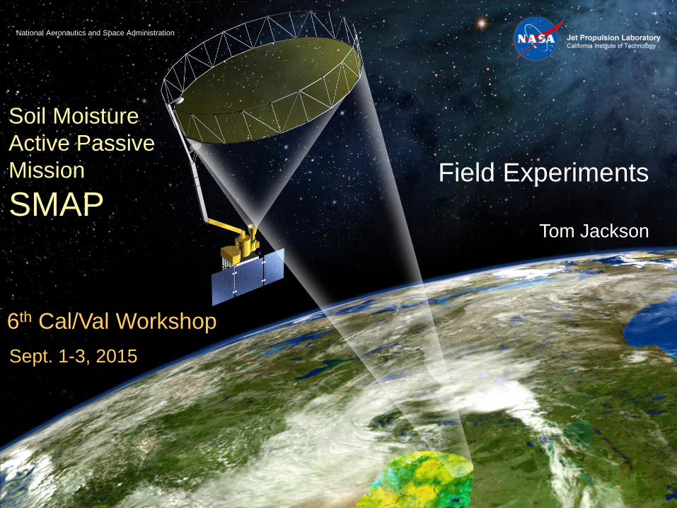
National Aeronautics and Space Administration
Soil Moisture
Active Passive
Mission
SMAP
6th Cal/Val Workshop
Sept. 1-3, 2015
Field Experiments
Tom Jackson

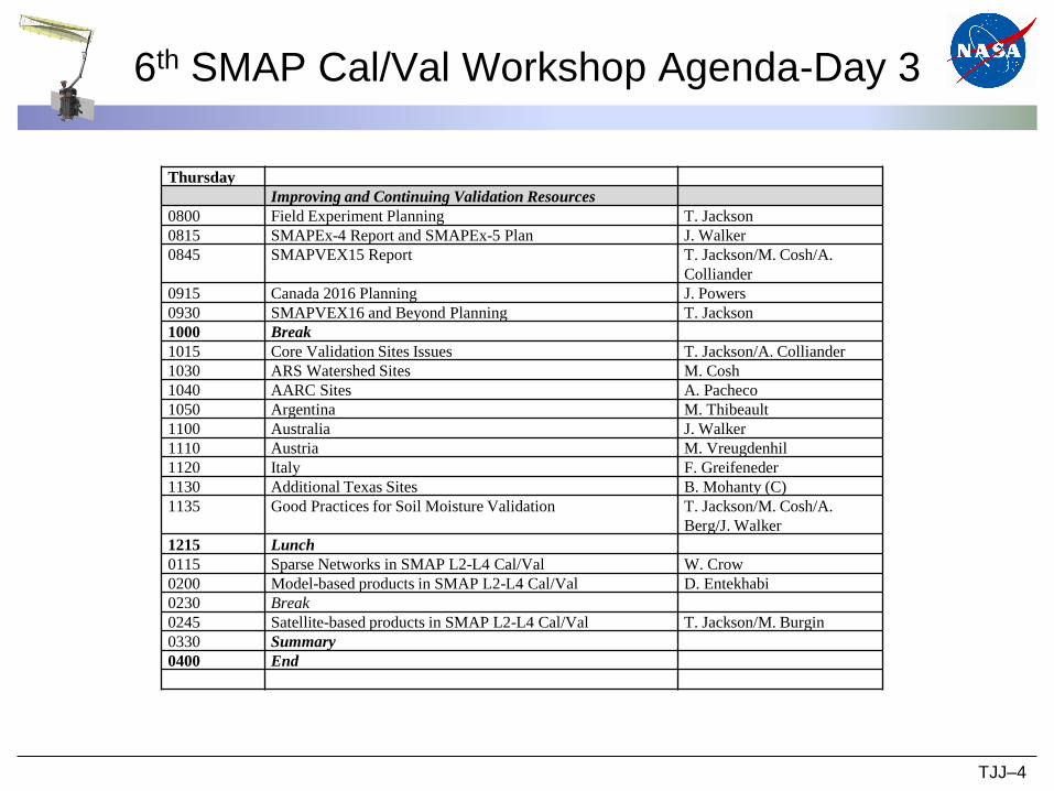
6th SMAP Cal/Val Workshop Agenda-Day 3
TJJ–2
Thursday
Improving and Continuing Validation Resources
0800 Field Experiment Planning T. Jackson
0815 SMAPEx-4 Report and SMAPEx-5 Plan J. Walker
0845 SMAPVEX15 Report T. Jackson/M. Cosh/A.
Colliander
0915 Canada 2016 Planning J. Powers
0930 SMAPVEX16 and Beyond Planning T. Jackson
1000 Break
1015 Core Validation Sites Issues T. Jackson/A. Colliander
1030 ARS Watershed Sites M. Cosh
1040 AARC Sites A. Pacheco
1050 Argentina M. Thibeault
1100 Australia J. Walker
1110 Austria M. Vreugdenhil
1120 Italy F. Greifeneder
1130 Additional Texas Sites B. Mohanty (C)
1135 Good Practices for Soil Moisture Validation T. Jackson/M. Cosh/A.
Berg/J. Walker
1215 Lunch
0115 Sparse Networks in SMAP L2-L4 Cal/Val W. Crow
0200 Model-based products in SMAP L2-L4 Cal/Val D. Entekhabi
0230 Break
0245 Satellite-based products in SMAP L2-L4 Cal/Val T. Jackson/M. Burgin
0330 Summary
0400 End
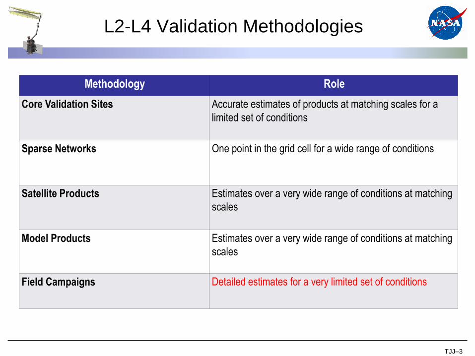
L2-L4 Validation Methodologies
TJJ–3
Methodology Role
Core Validation Sites Accurate estimates of products at matching scales for a
limited set of conditions
Sparse Networks One point in the grid cell for a wide range of conditions
Satellite Products Estimates over a very wide range of conditions at matching
scales
Model Products Estimates over a very wide range of conditions at matching
scales
Field Campaigns Detailed estimates for a very limited set of conditions
6th SMAP Cal/Val Workshop Agenda-Day 3
TJJ–4
Thursday
Improving and Continuing Validation Resources
0800 Field Experiment Planning T. Jackson
0815 SMAPEx-4 Report and SMAPEx-5 Plan J. Walker
0845 SMAPVEX15 Report T. Jackson/M. Cosh/A.
Colliander
0915 Canada 2016 Planning J. Powers
0930 SMAPVEX16 and Beyond Planning T. Jackson
1000 Break
1015 Core Validation Sites Issues T. Jackson/A. Colliander
1030 ARS Watershed Sites M. Cosh
1040 AARC Sites A. Pacheco
1050 Argentina M. Thibeault
1100 Australia J. Walker
1110 Austria M. Vreugdenhil
1120 Italy F. Greifeneder
1130 Additional Texas Sites B. Mohanty (C)
1135 Good Practices for Soil Moisture Validation T. Jackson/M. Cosh/A.
Berg/J. Walker
1215 Lunch
0115 Sparse Networks in SMAP L2-L4 Cal/Val W. Crow
0200 Model-based products in SMAP L2-L4 Cal/Val D. Entekhabi
0230 Break
0245 Satellite-based products in SMAP L2-L4 Cal/Val T. Jackson/M. Burgin
0330 Summary
0400 End

Aircraft Field Campaigns
• Experience has shown that the return on investment in field
campaigns can be significantly increased by engaging other
groups that can exploit the data set and enhance it with
additional observations.
TJJ–5
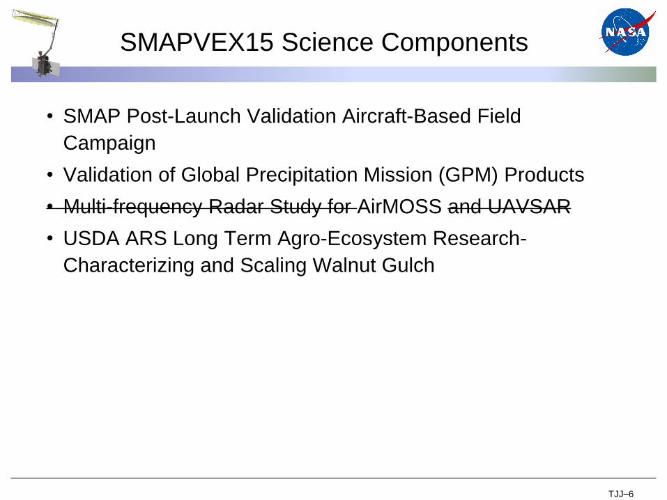
SMAPVEX15 Science Components
• SMAP Post-Launch Validation Aircraft-Based Field
Campaign
• Validation of Global Precipitation Mission (GPM) Products
• Multi-frequency Radar Study for AirMOSS and UAVSAR
• USDA ARS Long Term Agro-Ecosystem Research-
Characterizing and Scaling Walnut Gulch
TJJ–6
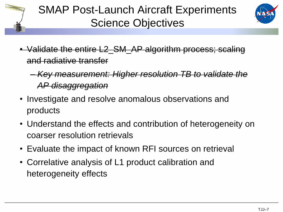
SMAP Post-Launch Aircraft Experiments
Science Objectives
• Validate the entire L2_SM_AP algorithm process; scaling
and radiative transfer
– Key measurement: Higher resolution TB to validate the
AP disaggregation
• Investigate and resolve anomalous observations and
products
• Understand the effects and contribution of heterogeneity on
coarser resolution retrievals
• Evaluate the impact of known RFI sources on retrieval
• Correlative analysis of L1 product calibration and
heterogeneity effects
TJJ–7
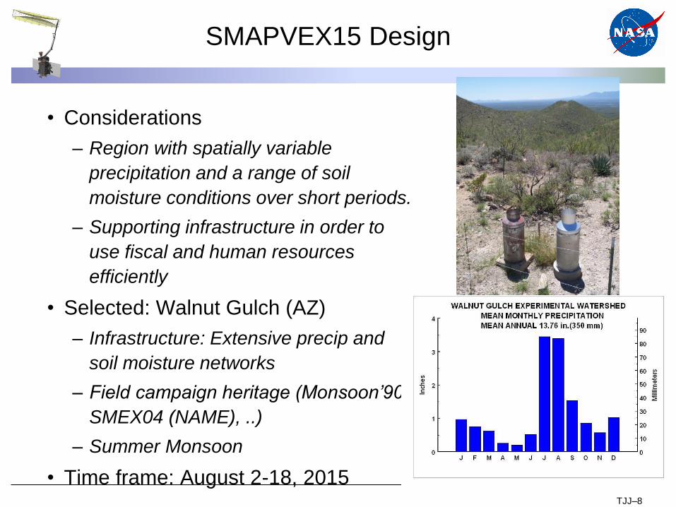
SMAPVEX15 Design
• Considerations
– Region with spatially variable
precipitation and a range of soil
moisture conditions over short periods.
– Supporting infrastructure in order to
use fiscal and human resources
efficiently
• Selected: Walnut Gulch (AZ)
– Infrastructure: Extensive precip and
soil moisture networks
– Field campaign heritage (Monsoon’90,
SMEX04 (NAME), ..)
– Summer Monsoon
• Time frame: August 2-18, 2015TJJ–8
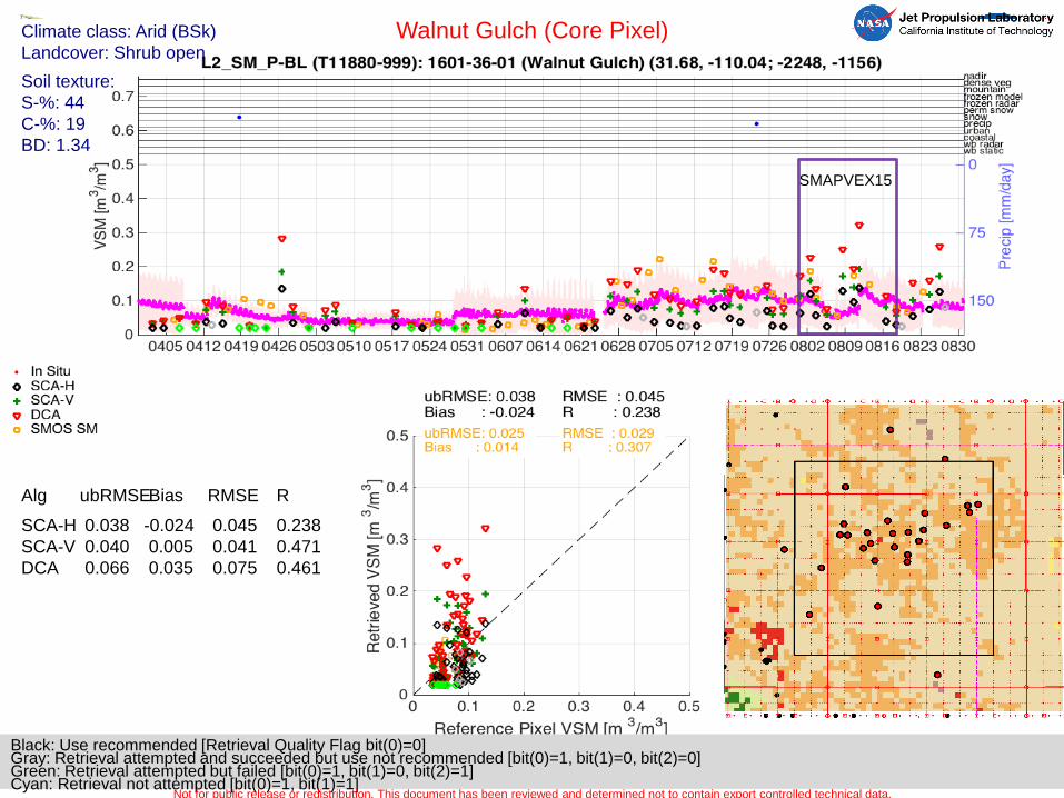
Black: Use recommended [Retrieval Quality Flag bit(0)=0]Gray: Retrieval attempted and succeeded but use not recommended [bit(0)=1, bit(1)=0, bit(2)=0]Green: Retrieval attempted but failed [bit(0)=1, bit(1)=0, bit(2)=1]Cyan: Retrieval not attempted [bit(0)=1, bit(1)=1]
Climate class: Arid (BSk)
Landcover: Shrub open
Soil texture:
S-%: 44
C-%: 19
BD: 1.34
Walnut Gulch (Core Pixel)
Not for public release or redistribution. This document has been reviewed and determined not to contain export controlled technical data.
Alg ubRMSEBias RMSE R
SCA-H
SCA-V
DCA
0.038
0.040
0.066
-0.024
0.005
0.035
0.045
0.041
0.075
0.238
0.471
0.461
SMAPVEX15
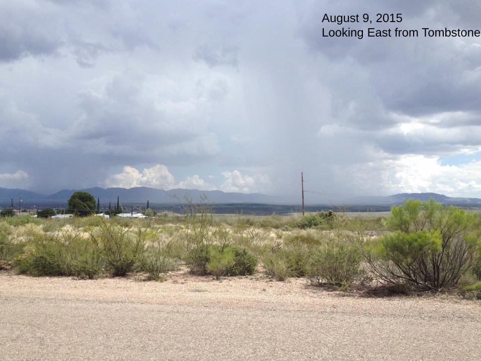
August 9, 2015
Looking East from Tombstone

SMAPVEX 15 Calendar
June 21 22 23
Install Temp SM
24 25
TELECON
26 27
28 29 30 July 1
Install Temp Precip
2 3 4
5 6 7 8 9 10 11
12 13 14 15 16
TELECON
17 18
19
L8W
20 21 22 23 24 25
26 27
IGARSS
28 L8E
IGARSS
29
IGARSS
30
IGARSS
31
IGARSS
TEAMS ARRIVE
PALS to Tuscon
August 1
Team Training
2
PALS 1
3 4 L8W 5
PALS 2
6 7 8
PALS 3
AirMOSS 1
Rover 1
9 10
PALS 4
AirMOSS 2
Rover 2
11 12 13 L8E
PALS 5
AirMOSS 3
Rover 3
14 15
16
PALS 6
AirMOSS 4
17 18
PALS 7
AirMOSS 5
19 20 L8W 21 22
23 24 25 26 27 28 29 L8E
30 31
Remove Temp Precip
Sept 1
SMAP C/V Workshop
2
SMAP C/V Workshop
3
SMAP C/V Workshop
4 5
SMAPVEX15 Key Features
• Ground-based (M. Cosh)
– Soil moisture
– Precipitation
– Ancillary
• Aircraft-based (A. Colliander)
– PALS
– AirMOSS
• Model-based products (W. Crow/E. Wood)
TJJ–12
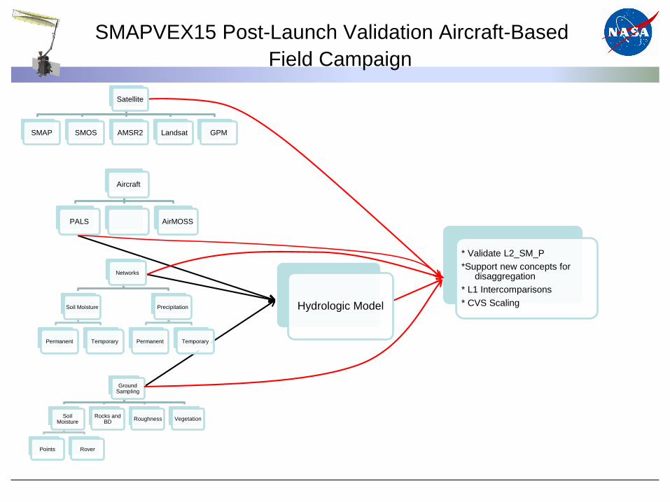
SMAPVEX15 Post-Launch Validation Aircraft-Based
Field Campaign
Aircraft
PALS AirMOSS
Networks
Soil Moisture
Permanent Temporary
Precipitation
Permanent Temporary
Ground Sampling
Soil Moisture
Points Rover
Rocks and BD
Roughness Vegetation
Hydrologic Model
* Validate L2_SM_P
*Support new concepts for disaggregation
* L1 Intercomparisons
* CVS Scaling
Satellite
SMAP SMOS AMSR2 Landsat GPM
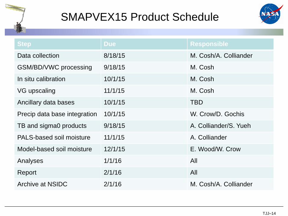
SMAPVEX15 Product Schedule
TJJ–14
Step Due Responsible
Data collection 8/18/15 M. Cosh/A. Colliander
GSM/BD/VWC processing 9/18/15 M. Cosh
In situ calibration 10/1/15 M. Cosh
VG upscaling 11/1/15 M. Cosh
Ancillary data bases 10/1/15 TBD
Precip data base integration 10/1/15 W. Crow/D. Gochis
TB and sigma0 products 9/18/15 A. Colliander/S. Yueh
PALS-based soil moisture 11/1/15 A. Colliander
Model-based soil moisture 12/1/15 E. Wood/W. Crow
Analyses 1/1/16 All
Report 2/1/16 All
Archive at NSIDC 2/1/16 M. Cosh/A. Colliander
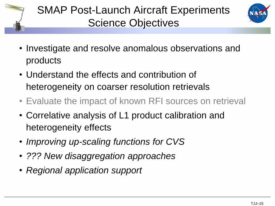
SMAP Post-Launch Aircraft Experiments
Science Objectives
• Investigate and resolve anomalous observations and
products
• Understand the effects and contribution of
heterogeneity on coarser resolution retrievals
• Evaluate the impact of known RFI sources on retrieval
• Correlative analysis of L1 product calibration and
heterogeneity effects
• Improving up-scaling functions for CVS
• ??? New disaggregation approaches
• Regional application support
TJJ–15
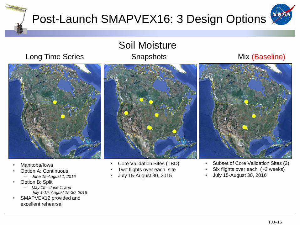
Post-Launch SMAPVEX16: 3 Design Options
• Manitoba/Iowa
• Option A: Continuous– June 15-August 1, 2016
• Option B: Split– May 15—June 1, and
July 1-15, August 15-30, 2016
• SMAPVEX12 provided and
excellent rehearsal
• Core Validation Sites (TBD)
• Two flights over each site
• July 15-August 30, 2015
• Subset of Core Validation Sites (3)
• Six flights over each (~2 weeks)
• July 15-August 30, 2016
Long Time Series Snapshots Mix (Baseline)
Soil Moisture
TJJ–16
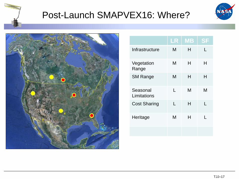
Post-Launch SMAPVEX16: Where?
LR MB SF
Infrastructure M H L
Vegetation
Range
M H H
SM Range M H H
Seasonal
Limitations
L M M
Cost Sharing L H L
Heritage M H L
TJJ–17
SMAPVEX16 Baseline
• Duration: 30 days (8-10 days for each site)
• Flight hours: 100 (70 for science and 30 for test flights
and transit.)
• Two Aircrafts: PALS on DC-3 and UAVSAR on G3 (TBD)
• Three sites: each site will cover 36 km x 36 km based on
- atch-up of in situ and retrievals
- Key site
- Strong science plan
- ……………..
TJJ–18
SMAPVEX16 Time Line
• Minimum time for SMAP data assessment: through
NA summer season 2015
• First assessment and candidate targets at Cal/Val
Workshop (Sept. 2015)
– New mission priorities?
• Initiate experiment planning Nov. 2015
• Field campaign July-August 2016
TJJ–19
SMAPVEX16+ Ideas?
• Forest sites
– Consider challenges of capturing variability of SM and
VWC
– Global importance of the conditions/site
• New disaggregation approaches
– Sentinel –challenge to design
– TIR/VIR
• New regional applications
– Crop yield
– Drought
– Floods
– Hurricane land fall
• Addressing new products (VWC/Tau, …)TJJ–20
SMAPVEX16+ Ideas?
• One of the least studied vegetation types is forests
• Not all forests are the same: most important?
Priorities?
• Difficult domains to work in
• Should have the potential to be a CVS
• Resources?
• Timeline?
• Proposal
TJJ–21
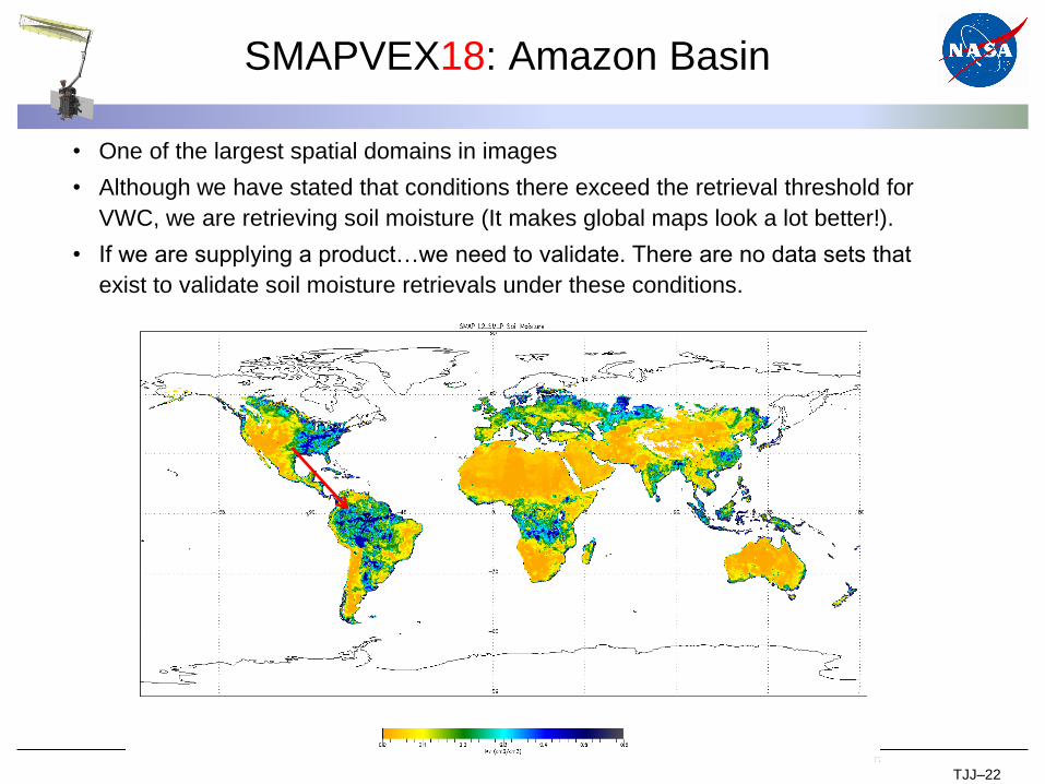
SMAPVEX18: Amazon Basin
• One of the largest spatial domains in images
• Although we have stated that conditions there exceed the retrieval threshold for
VWC, we are retrieving soil moisture (It makes global maps look a lot better!).
• If we are supplying a product…we need to validate. There are no data sets that
exist to validate soil moisture retrievals under these conditions.
TJJ–22
• Concept
– PALS deployment for two weeks for two seasons (wet Dec-May and
dry June-Nov). Choose several diverse sites and fly each two times.
– Temporal variability during each period is not necessary, the stability
over time is desired.
– Spatial variability within a site is desired.
– Coverage of SMAP grids with a resolution <3 km.
• Aircraft logistics will be a challenge.
• Ground observations
– Critical and will be THE major problem.
– In country collaboration is required.
– Linkages exist but $ support for this effort is probably not available
– Exploit existing efforts and temporary stations
• Scoping and feasibility (minimum 2-years planning)
Discussion with NiSAR and SWOT ST and HQ about interest
Contact INPE scientists
SMAPVEX18: Amazon Basin

6th SMAP Cal/Val Workshop Agenda-Day 3
TJJ–24
Thursday
Improving and Continuing Validation Resources
0800 Field Experiment Planning T. Jackson
0815 SMAPEx-4 Report and SMAPEx-5 Plan J. Walker
0845 SMAPVEX15 Report T. Jackson/M. Cosh/A.
Colliander
0915 Canada 2016 Planning J. Powers
0930 SMAPVEX16 and Beyond Planning T. Jackson
1000 Break
1015 Core Validation Sites Issues T. Jackson/A. Colliander
1030 ARS Watershed Sites M. Cosh
1040 AARC Sites A. Pacheco
1050 Argentina M. Thibeault
1100 Australia J. Walker
1110 Austria M. Vreugdenhil
1120 Italy F. Greifeneder
1130 Additional Texas Sites B. Mohanty (C)
1135 Good Practices for Soil Moisture Validation T. Jackson/M. Cosh/A.
Berg/J. Walker
1215 Lunch
0115 Sparse Networks in SMAP L2-L4 Cal/Val W. Crow
0200 Model-based products in SMAP L2-L4 Cal/Val D. Entekhabi
0230 Break
0245 Satellite-based products in SMAP L2-L4 Cal/Val T. Jackson/M. Burgin
0330 Summary
0400 End