Embed Size (px)
Citation preview

EO DATA APPLICATIONS IN CENTRAL AND SOUTH
AMERICA
Examples of environmental applications of Earth Observation data, methods and techniques
Ana B. Ruescas ESA/ESRIN
GIFT Workshop, Mérida, MX, 2010

Overview
•
ESA EO missions review•
The Diversity Project
•
The Jaguar Project•
EOPI
•
International Charter Space and major Disasters
•
ESA Initiative on Climate Change •
Remote Sensing Principles
•
Eduspace and LEOWorks 3.0

ESA EO missions reviewESA EO missions review
Meteosat
–
ESA has been dedicated to
observing Earth from space ever since the
launch of its first meteorological mission
(1977).
ERS-1 (1991)
and
ERS-2 (1995) –
providing
a wealth of invaluable data about Earth, its
climate and changing environment.
Envisat
–
the largest satellite ever built to
monitor the environment, it provides
continuous observation of Earth’s surface,
atmosphere, oceans and ice caps (2002).
PIONEERS IN EARTH OBSERVATION
GIFT Workshop, Mérida, MX, 2010

Part of ESA’s ‘Living Planet’
Programme, these
missions address critical and specific issues
raised by the science community, while
demonstrating the latest observing
techniques. The first two were launched in
2009:
GOCE
–
studying Earth’s gravity field
SMOS –
studying Earth’s water cycle
The next missions are:
CryoSat-2 –
studying Earth’s ice cover
ADM-Aeolus –
studying the atmosphere
Swarm –
three satellites to study Earth’s
magnetic field
EarthCARE
–
an ESA/JAXA mission to study
Earth’s clouds, aerosols and radiation
EARTH EXPLORERS
GIFT Workshop, Mérida, MX, 2010

‘Living Planet’
also includes the next
generation of missions dedicated to weather
and climate.
Meteosat
Third Generation
–
taking over
from Meteosat
11 in 2015, the last of four
Meteosat
Second Generation (MSG)
satellites. MSG is a joint project between ESA
and Eumetsat
following the success of the
first-generation Meteosat
satellites.
MetOp
–
a series of three satellites to
monitor climate and improve weather
forecasting, the space segment of Eumetsat's
Polar System (EPS).
MetOp-A –
Europe’s first polar-orbiting
satellite dedicated to operational
meteorology (2006).
METEOROLOGICAL MISSIONS
GIFT Workshop, Mérida, MX, 2010
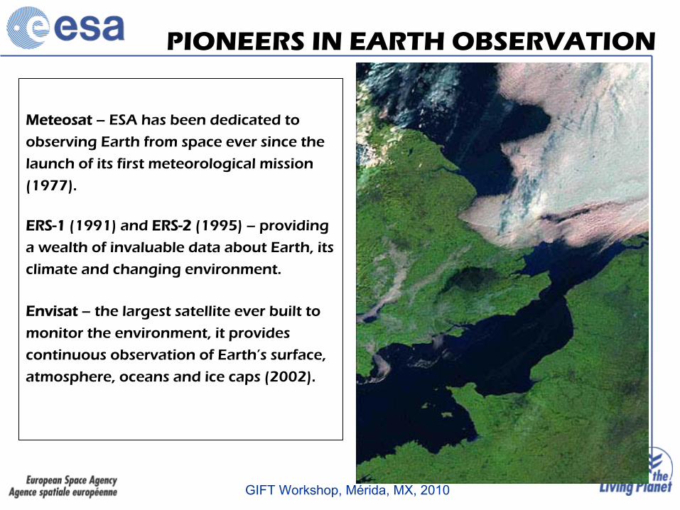
A joint ESA/European Commission
initiative, Global Monitoring for the
Environment and Security (GMES)
is the
response to Europe's need for geo-spatial
information services. It will provide
autonomous and independent access to
information for policy-makers, particularly
for environment and security issues.
ESA is implementing the space component:
developing the Sentinel satellite series, its
ground segment and coordinating data
access.
ESA is also starting a Climate Change
Initiative, for storage and production of
essential climate data.
OBSERVING OUR PLANET FOR A SAFER WORLD
GIFT Workshop, Mérida, MX, 2010

Diversity ProjectDiversity Project

GIFT Workshop, Mérida, MX, 2010

Diversity project
GIFT Workshop, Mérida, MX, 2010

Diversity project
GIFT Workshop, Mérida, MX, 2010

Diversity project
GIFT Workshop, Mérida, MX, 2010

Diversity project
http://www.geoville.com/diversity/products/GIFT Workshop, Mérida, MX, 2010

Diversity project: Mesoamerican biological corridor
GIFT Workshop, Mérida, MX, 2010

Diversity project: Mesoamerican biological corridor
GIFT Workshop, Mérida, MX, 2010

Diversity project: Coral reef maps
Coral reef maps and surfaces of coral bleaching
GIFT Workshop, Mérida, MX, 2010

Diversity project: mangrove maps
GIFT Workshop, Mérida, MX, 2010

Diversity project: wildlife migrations
Shark’s trajectories in the Tropical East Pacific Corridor (tracking data courtesy of MalpeloFoundation
GIFT Workshop, Mérida, MX, 2010

Jaguar ProjectJaguar Project

http://www.planjaguar.info
The goal of the JAGUAR PLAN is to design an action plan for European Space Agency (ESA), in order to promote the international development of the European and Canadian EO market in Latin America and the Caribbean.Actions:•
Market characterization: collected information referred to the situation of the EO market in
Latin America and the Caribbean region• The development of 4 miniprojects.•INDRA will provide an Action Plan
to ESA for the development of a Strategic Plan, focused on the expansion of the usage of European and Canadian EO products in Latin America and the Caribbean region, with an expected duration of five years.
GIFT Workshop, Mérida, MX, 2010

Jaguar Miniprojects
•
Miniproject
1. “Definition of the Lake Titicaca
Territorial Observatory”.
•
Miniproject
2. “Remote Sensing as an Instrument to
Manage Risks and to Develop Agrarian Insurances in the Rural Sector”.
•
Miniproject
3. “Cooperación
Urban Services (CUbS):
Viability analysis of remote sensing products for the urban management in LAC countries”.
•
Miniproject
4. “Methodology for an Enviromental
Audit for Oil & Gas Activity in Ecuador Using Earth Observation (EO) Data”.
GIFT Workshop, Mérida, MX, 2010

Earth ObservationEarth ObservationPrincipal InvestigatorsPrincipal Investigators

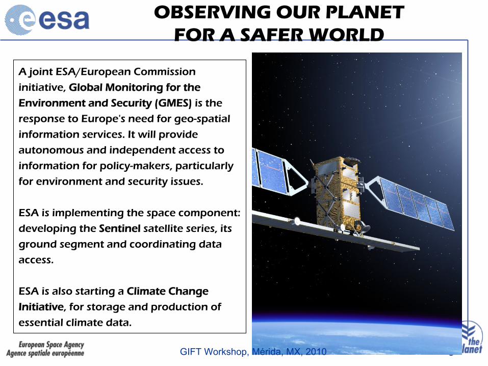
Principal Investigator Portal
GIFT Workshop, Mérida, MX, 2010
Principal Investigator Portal
•
Users who would like to submit scientific proposals for the use of ESA EO missions data
•
PIs of any accepted project willing to present their findings to
ESA •
Representatives of the ESA Member States, who can get up-to-date information on the on-going EO projects, their status and their achievements
•
Scientists working in connected fields who can find projects with related objectives and establish contact with other PIs
•
Students, who can find up to date information and contacts to leading R&D groups all over the world
•
Industry who can get a broad overview of state-of-the art projects in many EO application domains
•
The Aerospace industry, who can see the results obtained with systems and technologies they develop
•
Members of the broader user community who want to understand how EO could help in meeting their information needs
•
ESA staff involved in past, present and future Earth Observation
missions
GIFT Workshop, Mérida, MX, 2010

Principal Investigator Portal

•
23 proyectos científicos aprobados sobre América Latina, 2 de ellos ya cerrados.
•
Investigadores principales de 14 países.
•
9 temáticas diversas.
NUMERO EOPI AMERICA LATINA
0
1
2
3
4
5
6
Arg
entin
a
Aus
tria
Bra
sil
Can
ada
Chi
le
Est
ados
Uni
dos
Finl
andi
a
Fran
cia
Mex
ico
Nue
va Z
elan
da
Pai
ses
Baj
os
Per
u
Rei
no U
nido
Sui
za
paises
PI
SÓLO 7 INVESTIGADORES PRINCIPALES DE AMÉRICA LATINA
TEMATICA PROYECTOS
0
1
2
3
4
5
6
7
Topo
graf
ia
Tect
onic
a
Volc
anis
mo
Vege
taci
on
Hid
rolo
gia
Oce
anos
Gas
esat
mos
feric
os
Hie
lo/g
laci
ares
Cal
ibra
cion
sens
ores
temas
proy
ecto
sEO Principal Investigator Portal
GIFT Workshop, Mérida, MX, 2010

EOPI: DEFORMACIÓN DE LA TIERRA
Detecting ground deformation in landslides areas in Peru, by means of INSAR
(PI: Miguel Vidal Valdiviezo, Perú)
Surface deformation at Sierra Negra and Fernandina volcanoes, Galapagos
(PI: William Chadwick, USA)
Interferogramas de distintas fechas
GIFT Workshop, Mérida, MX, 2010

Subsidencia
en Mexico City -
Lopez-Quiroz
et al., 2008
EOPI: SUBSIDENCIAS URBANAS
GIFT Workshop, Mérida, MX, 2010

STUDY OF THE DEFORMATION FIELD OF TWO ACTIVE MEXICAN
STRATOVOLCANOES (POPOCATEPETL AND COLIMA VOLCANO) BY TIME SERIES
OF INSAR DATA (Pinel
et al.)
EOPI: VOLCANOES

International CharterInternational CharterSpace and Major DisastersSpace and Major Disasters

http://www.disasterscharter.org/home
INTERNATIONAL CHARTER SPACE AND MAJOR DISASTERS
GIFT Workshop, Mérida, MX, 2010

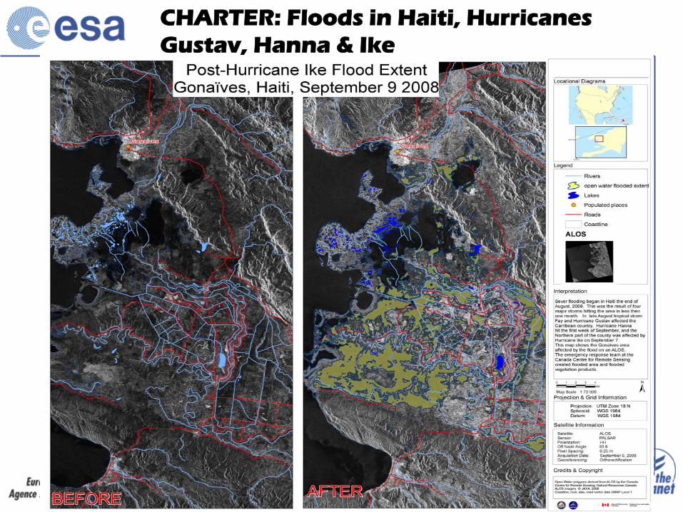
CHARTER: Floods
in Haiti, Hurricanes
Gustav, Hanna
& Ike
GIFT Workshop, Mérida, MX, 2010
CHARTER: Floods
in Haiti, Hurricanes
Gustav, Hanna
& Ike

CHARTER: Hurricane
Felix, Yucatan

CHARTER: Hurricane
Felix, Yucatan
GIFT Workshop, Mérida, MX, 2010

CHARTER : Chaiten
(Chile), February
2009
GIFT Workshop, Mérida, MX, 2010
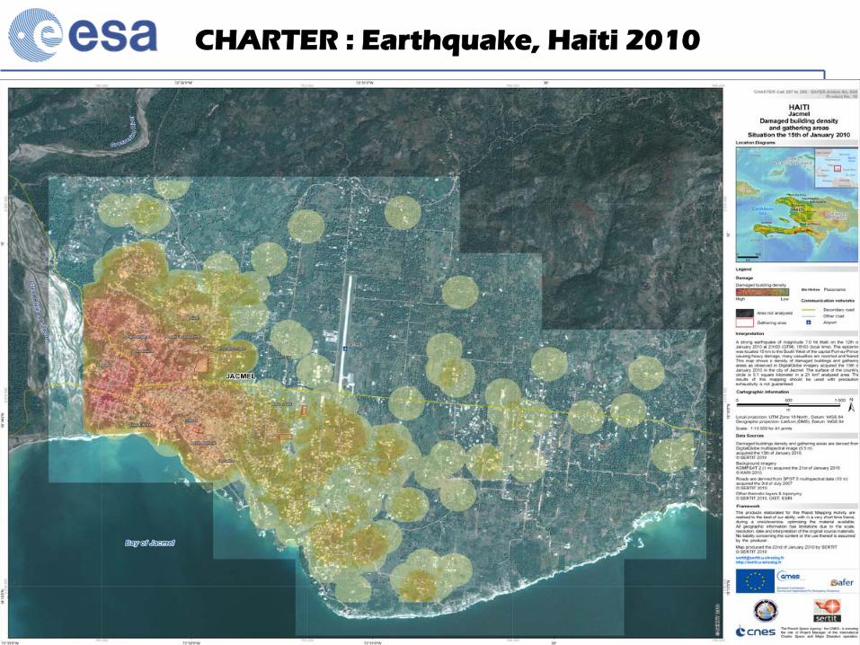
CHARTER : Earthquake, Haiti
2010

ESA Initiative onESA Initiative onClimate ChangeClimate Change

ESA Iniciativa sobre el Cambio Climático
El fundamento de la iniciativa:
Para generar y distribuir sistemáticamente series a largo plazo de “Variables climáticas esenciales” (ECV) para cubrir las necesidades de la UNFCCC y el IPCC, basado en datos de archivo de la ESA
ECV Records: Cuantificar el estado del sistema climático para (a) avanzar en el conocimiento y (b) respaldar el trabajo de UNFCCC y el IPCC para la migración y adaptación al cambio climático
Output :

ESA Initiative on Climate Change
UNFCCC Conference Dec 2007 Bali Action Plan“parties should describe the status of their programmes for contributing observations of the essential climate variables (ECVs) to the international community”
EO from space plays a vital role,
ESA to systematically generate and distribute long- term series of “Essential Climate Variables”
Based on ESA archived EO data (30 years),
Internationally agreed requirements
GCOS definition of ECV
CEOS response for required space observations
To quantify the state of the Climate system to
Advance our knowledge of climate change,
Support work of UNFCCC and IPCC for climate change mitigation and adaptation
5 year program, ~ 300M€, decision C-MIN Nov 2008

Remote Sensing PrinciplesRemote Sensing Principles

Scanning and Image Reconstruction (visible/IR)

Res
pons
e –
Sign
al st
reng
th
Time
abcd
Radar Antenne:Transmitter/Receiver
Impuls
Imaging Radar

The Electromagnetic Spectrum

El espectro electromagnético
VISIBLE

Infrarrojo térmico

RADAR


Eduspace and Eduspace and LEOWorks 3.0LEOWorks 3.0

•
Eduspace initiative based on a 98 EURISY workshop on education
•
Carried out under umbrella of EURISY by ESA and by some of its national and industrial Partners:
Danish Ministry of Education, representing the final users (professors and teachers)
Norwegian Space Centre (NSC), providing also the initial nucleus from the educational SAREPTA Web Site (which was co-sponsored by ESA PR a long time before)
British National Space Centre (BNSC), contributing to the initial project proposal and towards funding Eurimage, providing access to Landsat imagery
Geospace, Austria, providing access to their “The Alps from Space”
high-resolution satellite database.
• Transferred in 2002 from EURISY to ESA
History of Eduspace

EDUSPACE
•
To inspire teachers to incorporate Earth observation into their curricula
•
To provide ready-made curricula projects
•
To provide tools and Earth observation data for educational purposes
•
To enable schools to take part in collaborative work in Earth observation through a network
GIFT Workshop, Mérida, MX, 2010
OBJECTIVES

•
Secondary school teachers who want to incorporate EO into their curricula
•
Secondary school students to extend on what they have learned in class
• University students pursuing related academic studies
• Access to website www.esa.int/eduspace is free
Target Groups

Eduspace Website Hits
Mar
-02
Sep
-02
Mar
-03
Sep
-03
Mar
-04
Sep
-04
Mar
-05
Sep
-05
Mar
-06
Sep
-06
Mar
-07
Sep
-07
0
200000
400000
600000
800000
1000000
1200000
Edu
spac
e H
its
Month
Eduspace Hits from March 2002 to December 2007
Low values correspond to school holidays

http://imagedbk- srv.esrin.esa.int/Eduspace_Installer/install. htm
EDUSPACE
http://earth.eo.esa.int/satelliteimages/

EDUSPACE: Case studies
DonwloadData

http://miravi.eo.esa.int/en/
GIFT Workshop, Mérida, MX, 2010

E-learning
GIFT Workshop, Mérida, MX, 2010
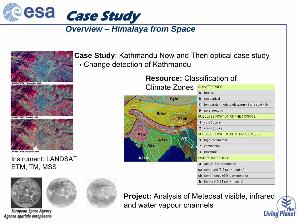
Case Study: Kathmandu Now and Then optical case study→ Change detection of Kathmandu
Instrument: LANDSAT ETM, TM, MSS
Resource: Classification of Climate Zones
Project: Analysis of Meteosat
visible, infrared and water vapour channels
Case StudyOverview – Himalaya from Space

LEOWorks 3.0
Image Processing Software (with GIS functionality)•
View images, histogram, pixel values, header info
•
Crop, invert, stretch, layer stack, etc
•
Image arithmetic, filters
•
Classification, PCA, geometric correction, pan sharpening
•
GIS tools

LEOWorks
Classification ExampleClassification of Hanoi

Image Resources Image Catalogue
•
The EduSpace
Image Catalogue software is developed by Terranova
incollaboration with ESA/ESRIN. It allows the user to perform multi –mission inventory searches on the main ESA –
supported missions
•
Eduspace Image Catalogue is an application composed principally by twomain viewers, positioned in the centre of the application
-The first shows satellite images from data-bank-The second shows a map of the area covered by EduSpace
project
•
Eduspace Image Catalogue application can be downloaded at pagehttp://imagedbk-srv.esrin.esa.int/Eduspace_Installer/install.htm

For each downloaded image there is a read-me file containing image information
Image Catalogue
Eduspace Image Catalogue allows multi-mission inventory searches of the main ESA supported missions. Registered users can download selected sections of scenes of size 1000 x 1000 pixels