Embed Size (px)
Citation preview
Luca Ferrari, 1
DR2004012
Data Repository Item Figure DR1 This map is a simplification of the electronic document “Digital Cartography of the Trans-Mexican Volcanic Belt” available at URL: http://satori.geociencias.unam.mx/Digital_Geosciences/ The map was compiled by the author based on geologic information from published sources and unpublished geologic maps provided by José Rosas, Gerardo Carrasco, Angel Nieto, Susana Alaniz and Maria Teresa Orozco, as well as his own mapping. Source of data used in Figure 3
Figure 3 used data compiled to May 2003 for mafic volcanic rocks of late Miocene to early Pliocene that define an eastward migrating pulse of volcanism in central Mexico. These data are listed in Table 1. Data with experimental error >10% of the age were discarded. Published data were compiled from the following sources: Aguirre-Diaz, G., and López, Martínez M, 2001, The Amazcala caldera, Queretaro, Mexico:
Geology and Geochronology: Journal of Volcanology and Geothermal Research, v. 111, p. 203-218.
Allan, J. F., 1986, Geology of the Colima and Zacoalco grabens, SW Mexico: Late Cenozoic rifting in the Mexican Volcanic Belt. Geological Society of America Bulletin, v. 97, p. 473-485.
Carranza-Castañeda, O., Petersen, M. S., and Miller, W. E., 1994, Preliminary investigation of the Geology of northern San Miguel de Allende area, northeastern Guanajuato, Mexico: Brigham Young University Geological Studies, v. 40, p. 1-9.
Castillo, D., and Romero, F., 1991, Estudio geologico-regional de Los Altos, Jalisco y El Bajio: Comisión Federal de Electricidad, Gerencia de Proyectos Geotermoelectricos, Departamento de Exploración, Open File Report, n. 02-91, 35 p.
Cerca Martínez, L.M., 1998, Relacion estratigrafica y geocronologica entre el volcanismo de la Sierra Madre Occidental y el Cinturon Volcanico Mexicano en la parte sur de la Sierra de Guanajuato. M. Sc. Thesis, Dept. of Geology, CICESE, 119 p.
Damon, P.E., Nieto, O.J. and Delgado, A.L., 1979, Un plegamiento neogenico en Nayarit y Jalisco y evolución geomorfica del Rio Grande de Santiago: Asociacion Ingenieros Mineros, Metalurgicos y Geologos de Mexico, Memoria Tecnica XIII, p. 156-191.
Delgado, G. H., Urrutia-Fucugauchi, J., Hasenaka, T. and Ban, M., 1995. Southwestward volcanic migration in the western Trans-Mexican Volcanic Belt during the last 2 Ma: Geofìsica Internacional, v. 34, p. 341-352.
Ferrari L., Conticelli S., Vaggelli G., Petrone C.M., and Manetti P., 2000, Late Miocene mafic volcanism and intraarc tectonics during the early development of the Trans-Mexican volcanic belt: Tectonophysics, v. 318, p. 161–185.
Gastil, R. G., Krummenacher, D., and Minch, J., 1979, The record of Cenozoic volcanism around the Gulf of California: Geological Society of America Bulletin, v. 90, p. 839-857.
Hasenaka, T., Uto, K., Uchiumi, S., Yoshida, T., Ishikawa, K., and Ramos-Salinas, A., 1994, La Ordeña caldera: Science Report, Institute of Mineralogy, Petrology and Economic Geology, Faculty of Sciences, Tohoku University, v. 27, p. 43-53 (in Japanese).
Jacobo-Albarrán, J., 1986. Estudio petrogenetico de las rocas igneas de la porción central del Eje Neovolcánico: Instituto Mexicano del Petroleo, Subdirección de Tecnología de Exploración, Open File Report, Proyecto C-2006, 47 p.
Luca Ferrari, 2
Lopez-Infanzon, M., 1990, Petrologic study of the volcanic rocks in the Sierra de Chiconquiaco - Palma Sola, central Veracruz, Mexico: Master Thesis, Tulane University, New Orleans, U.S.A., 140 pp.
Moore, G., Marone, C., Carmichael, I. S. E., and Renne, P., 1994, Basaltic volcanism and extension near the intersection of the Sierra Madre volcanic province and the Mexican Volcanic Belt: Geological Society of America Bulletin, v. 106, p. 383-394.
Nieto-Obregon, J., Delgado-Argote, L., and Damon, P. E., 1981, Relaciones petrológicas y geocronológicas del magmatismo de la Sierra Madre Occidental y el Eje Neovolcánico en Nayarit, Jalisco y Zacatecas: Asociación Ingenieros Mineros, Metalurgicos y Geólogos de México, Memoria Técnica, v. XIV, p. 327-361.
Nieto-Obregon, J., Delgado-Argote, L., and Damon, P. E., 1985, Geochronologic, petrologic and structural data related to large morphologic features between the Sierra Madre Occidental and the Mexican Volcanic Belt: Geofisica Internacional, v. 24, p. 623-663.
Nixon, G. T., Demant, A. , Amstrong, R. L., and Harakal, J. E., 1987, K-Ar and geologic data bearing on the age and evolution of the Trans-Mexican Volcanic Belt: Geofìsica Internacional, v. 26, p. 109-158.
Pasquarè, G., Ferrari, L., Garduño, V. H., Tibaldi, A., and Vezzoli, L., 1991, Geologic map of the central sector of the Mexican Volcanic Belt, States of Guanajuato and Michoacán, Mexico: Geological Society of America, Map and Chart Series, MCH 072, 1 sheet, 21p.
Righter, K., Carmichael, I. S. E., and Becker, T., 1995, Pliocene -Quaternary faulting and volcanism at the intersection of the Gulf of California and the Mexican Volcanic Belt: Geological Society of America Bulletin, v.107, p. 612-626.
Rosas-Elguera, J., Urrutia-Fucugauchi, J., and Maciel, R.F., 1989, Geologia del extremo oriental del Graben de Chapala; breve discusion sobre su edad: zonas geotermicas Ixtlan de Los Hervores-Los Negritos, Mexico: Geotermia - Revista Mexicana de Geoenergia, v. 5, p. 3-18.
Rosas-Elguera J., Ferrari L., Lopez-Martinez M., and Urrutia-Fucugauchi J., 1997, Stratigraphy and tectonics of the Guadalajara region and the triple junction area, western Mexico: International Geology Review, v. 39, p. 125-140.
Rosas-Elguera, J., and Urrutia-Fucugauchi, J., 1998, Tectonic control on the volcano-sedimentary sequence of the Chapala graben, western Mexico: International Geology Review, v. 40, p. 350-362.
Soto, M.A., and Ortega, J.G., 1982, Geologia del Rio Santiago en los estados de Jalisco y Nayarit, Mexico: Memoria XII° Convención Sociedad Geológica Mexicana, 20 pp.
Suter, M., Carrillo, M., Lopez, M., and Farrar, E., 1995, The Aljibes half-graben, active extension at the boundary between the trans-Mexican Volcanic Belt and the southern Basin and Range: Geological Society of America Bulletin, v. 107, p. 627-641.
Venegas, S., Herrera, J.J., and Maciel, F.R., 1985, Algunas características de la Faja Volcánica Mexicana y de sus recursos geotérmicos: Geofísica Internacional, v.24. p. 47-83.
Verma, S. P., Lopez-Martinez, M. and Terrell, D.J., 1985, Geochemistry of Tertiary igneous rocks from Arandas-Atotonilco area, northeast Jalisco, Mexico: Geofísica Internacional, v. 24, p. 31-45.
Watkins, N.D., Gunn, B.M., Baksi, A.K., York, D., and Ade-Hall, J., 1971, Paleomagnetism, geochemistry and potassium-argon ages of the Rio Grande de Santiago volcanics, Central Mexico: Geological Society of America Bulletin, v. 82, p. 1955-1968.
Figure DR2
Plot of Miocene to Holocene ages (656 data points) for central Mexico against distance from present trench for three arc segments. Ages are part of the electronic document “Digital Cartography of the Trans-Mexican Volcanic Belt” available at URL: http://satori.geociencias.unam.mx/Digital_Geosciences/
Luca Ferrari, 3
Gray bars indicate ages of mafic pulse produced by detachment. Note increasing amount of trenchward migration of arc and, particularly, of volcanic front toward eastern part of Trans-Mexican volcanic belt (TMVB).

1° 45'
106° 00'0° 30'
C. Telapón
C. Tlaloc
Iztaccihuatl
Popocatepetl
Sierra de Guadalupe
Sierra de las Cruces
S i e r r a C h i c h i n a u t z i n
Xitle
Ajusco
Zempoala
C. San Antonio
V. Jocotitlán
La Malinche
Las Navajas
HuichapanCaldera
AmealcoCaldera
La JoyaPalo Huerfano
El Zamorano
Sierra de Penjamo
C H A P A L A L A K E
Sierra de Angangueo
SANGANGÜEY
GUADALAJARA
TEPIC
PUERTO VALLARTA
AMECA
CIUDAD GUZMAN
URUAPAN
COLIMA
MORELIA
PATZCUARO
ZACAPU
SALAMANCA
IRAPUATO
SILAO
MOROLEÓN
CELAYA
ZITACUARO
SAN JUAN DEL RIO
PACHUCA
Actopan
Tulancingo
QUERETARO
CUERNAVACA
Cuautla
CUITZEO LAKE
M E X I C OC I T Y
PUEBLA
APATZINGAN
TOLUCA
Volcan Gordo
Nevado de Toluca
Volcan Ajusco
Tecamachalco
ORIZABA
Cofre de Perote
XALAPA
CÓRDOVA
VERACRUZ
Agustinos
Martinez de la Torre
POZA RICA
LOS HUMEROS CALDERA
Pico de Orizaba
Cerro La Cumbre
Sierra Negra
Iguala
Simplified geologic map of the Trans-Mexican Volcanic Belt
#
Faults
Geologic units
Silicic ignimbrites and domes (Quaternary)
Mafic to intermediate volcanism (Late Pliocene - Quaternary)
Debris avalanches, lahars and epiclastics (Quaternary)
Silicic domes, flows and ignimbrites (Pliocene)
Basaltic and andesitic lava flows and shield volcanoes (6 - 3 Ma)
Silicic to intermediate domes (7.5 - 5 Ma)
Basaltic plateaux and shield volcanoes (11.5 - 7.5 Ma)
Andesitic to dacitic volcanic complexes (17 - 10 Ma)
Legend
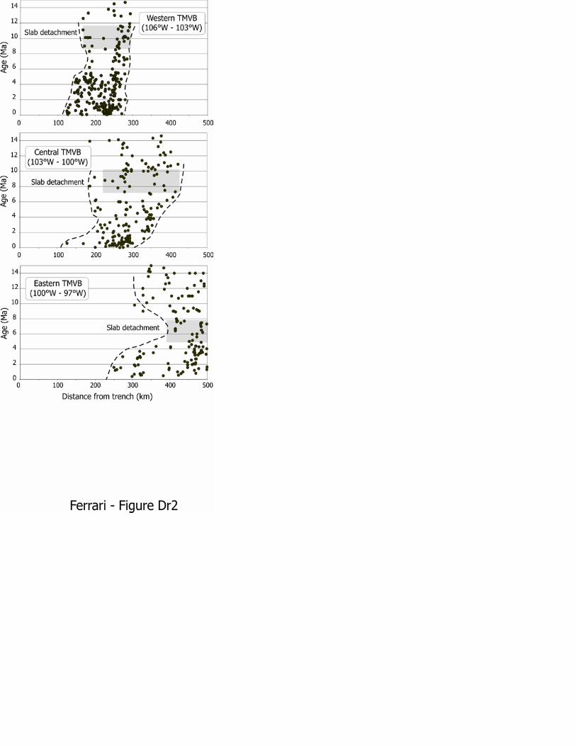
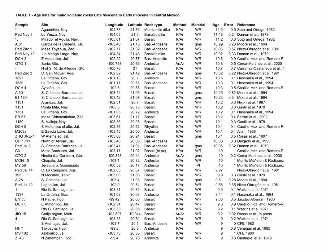
TABLE 1 - Age data for mafic volcanic rocks Late Miocene to Early Pliocene in central Mexico
Sample Site Longitude Latitude Rock type Method Material Age Error Reference*I Aguamilpa, Nay. -104.77 21.86 Monzonitic dike K/Ar WR 11.5 0.5 Soto and Ortega, 1982Ped Nay 3 La Yesca, Nay. -104.03 21.3 Basaltic dike K/Ar WR 11.48 0.24 Damon et al., 1979*J Mirador el Aguila, Nay. -105.01 21.67 Basalt K/Ar WR 11.2 0.8 Soto and Ortega, 1982A 81 Garcia de la Cadena, Jal. -103.48 21.18 Bas.-Andesite K/Ar gms 10.99 0.23 Moore et al., 1994Ped Zac 1 Mesa Toyahua, Zac -102.77 21.32 Bas.-Andesite K/Ar WR 10.96 0.57 Nieto-Obregón et al. 1981Ped Nay 12 La Manga Larga, Nay. -104.34 21.43 Basaltic dike K/Ar WR 10.92 0.33 Damon et al., 1979DCH 2 E Atotonilco, Jal. -102.22 20.57 Bas. Andesite K/Ar WR 10.8 0.9 Castillo-Hdz. and Romero-RiGTO 1 Soria, Gto. -100.758 20.66 Andesite Ar/Ar WR 10.8 0.5 Cerca-Martinez et al., 2000- N of S. M. de Allende, Gto. -100.76 21 Basalt K/Ar WR 10.7 0.7 Carranza-Castaneda et al., 1Ped Zac 2 C. San Miguel, Ags. -102.82 21.42 Bas.-Andesite K/Ar gms 10.52 0.22 Nieto-Obregón et al. 19811327 La Ordeña, Gto. -101.13 20.7 Andesite K/Ar WR 10.5 0.1 Hasenaka et al., 19941330 La Ordeña, Gto. -101.17 20.68 Bas.-Andesite K/Ar WR 10.3 0.1 Hasenaka et al., 1994DCH 4 Ayotlàn, Jal. -102.3 20.55 Basalt K/Ar WR 10.3 0.5 Castillo-Hdz. and Romero-RiA 30 S. Cristobal Barranca, Jal. -103.42 21.05 Basalt K/Ar gms 10.25 0.82 Moore et al., 199461-180 S. Cristobal Barranca, Jal. -103.42 21.07 Basalt K/Ar gms 10.23 0.34 Moore et al., 19941131 Arandas, Jal. -102.31 20.7 Basalt K/Ar WR 10.2 0.3 Nixon et al. 19871151 Punta Mita, Nay. -105.5 20.78 Basalt K/Ar WR 10.2 0.8 Gastil et al. 19791331 La Ordeña, Gto. -101.05 20.72 Andesite K/Ar WR 10.2 0.1 Hasenaka et al., 1994PR 67 Mesa Chinacatiahua, Zac. -103.61 21.17 Basalt K/Ar WR 10.2 0.4 Ferrari et al., 20021150 S. Vallejo, Nay. -105.36 20.95 Basalt K/Ar WR 10.1 0.3 Gastil et al. 1979DCH 9 S Atotonilco el alto, Jal. -102.38 20.52 Rhyolite K/Ar WR 10.1 0.4 Castillo-Hdz. and Romero-RiM203a E Sayula Lake, Jal. -103.45 20.06 Andesite K/Ar WR 10.1 0.4 Allan, 1986ZHG JRE-7 W Atemajac, Jal. -103.68 20.24 Basalt K/Ar gms 10.1 0.5 Rosas et al., 1997CHP 711 North of Atoyac, Jal. -103.48 20.08 Bas.-Andesite K/Ar 10.08 0.8 Delgado et al., 1995Ped Jal 8 S. Cristobal Barranca, Jal. -103.41 21.01 Bas.-Andesite K/Ar gms 10.05 0.32 Damon et al., 1979C3 Mesa Barduces, Jal. -103.17 21.02 Basalt (ol px) K/Ar WR 10 1 Castillo-Hdz. and Romero-RiGTO 2 Neutla (La Cantera), Gto. -100.813 20.41 Andesite Ar/Ar gms 10 0.2 Cerca-Martinez et al., 2000MON 10 Chapala, Jal. -103.1 20.32 Andesite K/Ar WR 10 1 Murillo Muñeton & Rodiguez MS 56 Jerecuaro, Guanajuato -100.58 20.17 Andesite K/Ar Pl 10 1 Murillo Muñeton & Rodiguez Ped Jal 14 C. La Campana, Ags. -102.85 20.87 Basalt K/Ar WR 9.97 Nieto-Obregón et al. 1981193 N Mecatan, Tepic -105.08 21.68 Basalt K/Ar WR 9.9 0.3 Gastil et al. 1979A 28 S. Cristobal, Jal. -103.4 21.03 Basalt K/Ar gms 9.61 0.28 Moore et al., 1994Ped Jal 12 Lagunillas, Jal. -102.9 20.84 Basalt K/Ar WR 9.58 0.35 Nieto-Obregón et al. 19811 Rio G. Santiago, Jal. -103.31 20.85 Basalt K/Ar WR 9.5 0.1 Watkins et al. 19711337 La Ordeña, Gto. -101.02 20.68 Andesite K/Ar WR 9.44 0.1 Hasenaka et al., 1994EN 33 N Pathè, Hgo. -99.42 20.68 Basalt K/Ar WR 9.38 0.5 Jacobo-Albarrán, 1986DCH 5 E Atotonilco, Jal. -102.34 20.47 Basalt K/Ar WR 9.3 0.9 Castillo-Hdz. and Romero-Ri2 Rio G. Santiago, Jal. -103.33 20.85 Basalt K/Ar WR 9.2 0.1 Watkins et al. 1971JIQ 15 Cotija region, Mich. -102.807 19.944 Basalt Ar/Ar WR 9.2 0.92 Rosas et al., in press4 Rio G. Santiago, Jal. -103.33 20.81 Basalt K/Ar WR 9 0.2 Watkins et al. 1971* S Atemajac, Jal. -103.7 20.1 Bas.-Andesite K/Ar WR 9 0 CFE 1980HF 7 Taxbatha, Hgo. -99.6 20.5 Andesite K/Ar 9 0.8 Venegas et al. 1985MS 102 Atotonilco, Jal. -103.75 20.33 Basalt K/Ar WR 9 1 CFE 1980ZI 43 N Zimampan, Hgo. -99.4 20.78 Andesite K/Ar WR 9 0.3 Cantagrel et al. 1979
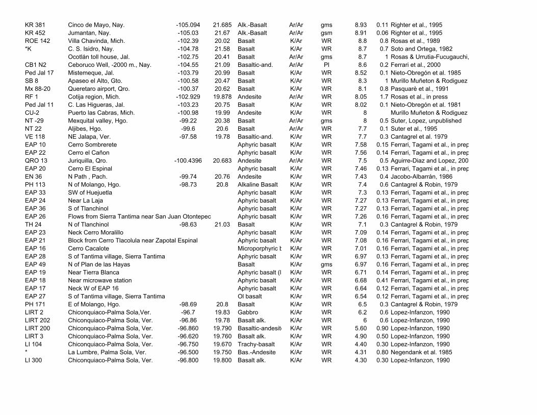
KR 381 Cinco de Mayo, Nay. -105.094 21.685 Alk.-Basalt Ar/Ar gms 8.93 0.11 Righter et al., 1995KR 452 Jumantan, Nay. -105.03 21.67 Alk.-Basalt Ar/Ar gsm 8.91 0.06 Righter et al., 1995ROE 142 Villa Chavinda, Mich. -102.39 20.02 Basalt K/Ar WR 8.8 0.8 Rosas et al., 1989*K C. S. Isidro, Nay. -104.78 21.58 Basalt K/Ar WR 8.7 0.7 Soto and Ortega, 1982
Ocotlán toll house, Jal. -102.75 20.41 Basalt Ar/Ar gms 8.7 1 Rosas & Urrutia-Fucugauchi,CB1 N2 Ceboruco Well, -2000 m., Nay. -104.55 21.09 Basaltic-and. Ar/Ar Pl 8.6 0.2 Ferrari et al., 2000Ped Jal 17 Mistemeque, Jal. -103.79 20.99 Basalt K/Ar WR 8.52 0.1 Nieto-Obregón et al. 1985SB 8 Apaseo el Alto, Gto. -100.58 20.47 Basalt K/Ar WR 8.3 1 Murillo Muñeton & Rodiguez Mx 88-20 Queretaro airport, Qro. -100.37 20.62 Basalt K/Ar WR 8.1 0.8 Pasquarè et al., 1991RF 1 Cotija region, Mich. -102.929 19.878 Andesite Ar/Ar WR 8.05 1.7 Rosas et al., in pressPed Jal 11 C. Las Higueras, Jal. -103.23 20.75 Basalt K/Ar WR 8.02 0.1 Nieto-Obregón et al. 1981CU-2 Puerto las Cabras, Mich. -100.98 19.99 Andesite K/Ar WR 8 Murillo Muñeton & Rodiguez NT -29 Mexquital valley, Hgo. -99.22 20.38 Basalt Ar/Ar gms 8 0.5 Suter, Lopez, unpublishedNT 22 Aljibes, Hgo. -99.6 20.6 Basalt Ar/Ar WR 7.7 0.1 Suter et al., 1995VE 118 NE Jalapa, Ver. -97.58 19.78 Basaltic-and. K/Ar WR 7.7 0.3 Cantagrel et al. 1979EAP 10 Cerro Sombrerete Aphyric basalt K/Ar WR 7.58 0.15 Ferrari, Tagami et al., in prepEAP 22 Cerro el Cañon Aphyric basalt K/Ar WR 7.56 0.14 Ferrari, Tagami et al., in prepQRO 13 Juriquilla, Qro. -100.4396 20.683 Andesite Ar/Ar WR 7.5 0.5 Aguirre-Diaz and Lopez, 200EAP 20 Cerro El Espinal Aphyric basalt K/Ar WR 7.46 0.13 Ferrari, Tagami et al., in prepEN 36 N Path , Pach. -99.74 20.76 Andesite K/Ar WR 7.43 0.4 Jacobo-Albarrán, 1986PH 113 N of Molango, Hgo. -98.73 20.8 Alkaline Basalt K/Ar WR 7.4 0.6 Cantagrel & Robin, 1979EAP 33 SW of Huejuetla Aphyric basalt K/Ar WR 7.3 0.13 Ferrari, Tagami et al., in prepEAP 24 Near La Laja Aphyric basalt K/Ar WR 7.27 0.13 Ferrari, Tagami et al., in prepEAP 36 S of Tlanchinol Aphyric basalt K/Ar WR 7.27 0.13 Ferrari, Tagami et al., in prepEAP 26 Flows from Sierra Tantima near San Juan Otontepec Aphyric basalt K/Ar WR 7.26 0.16 Ferrari, Tagami et al., in prepTH 24 N of Tlanchinol -98.63 21.03 Basalt K/Ar WR 7.1 0.3 Cantagrel & Robin, 1979EAP 23 Neck Cerro Moralillo Aphyric basalt K/Ar WR 7.09 0.14 Ferrari, Tagami et al., in prepEAP 21 Block from Cerro Tlacolula near Zapotal Espinal Aphyric basalt K/Ar WR 7.08 0.16 Ferrari, Tagami et al., in prepEAP 16 Cerro Cacalote Microporphyric b K/Ar WR 7.01 0.16 Ferrari, Tagami et al., in prepEAP 28 S of Tantima village, Sierra Tantima Aphyric basalt K/Ar WR 6.97 0.13 Ferrari, Tagami et al., in prepEAP 49 N of Plan de las Hayas Basalt K/Ar gms 6.97 0.16 Ferrari, Tagami et al., in prepEAP 19 Near Tierra Blanca Aphyric basalt (la K/Ar WR 6.71 0.14 Ferrari, Tagami et al., in prepEAP 18 Near microwave station Aphyric basalt K/Ar WR 6.68 0.41 Ferrari, Tagami et al., in prepEAP 17 Neck W of EAP 16 Aphyric basalt K/Ar WR 6.64 0.12 Ferrari, Tagami et al., in prepEAP 27 S of Tantima village, Sierra Tantima Ol basalt K/Ar WR 6.54 0.12 Ferrari, Tagami et al., in prepPH 171 E of Molango, Hgo. -98.69 20.8 Basalt K/Ar WR 6.5 0.3 Cantagrel & Robin, 1979LIRT 2 Chiconquiaco-Palma Sola,Ver. -96.7 19.83 Gabbro K/Ar WR 6.2 0.6 Lopez-Infanzon, 1990LIRT 202 Chiconquiaco-Palma Sola, Ver. -96.86 19.78 Basalt alk. K/Ar WR 6 0.6 Lopez-Infanzon, 1990LIRT 200 Chiconquiaco-Palma Sola, Ver. -96.860 19.790 Basaltic-andesite K/Ar WR 5.60 0.90 Lopez-Infanzon, 1990LIRT 3 Chiconquiaco-Palma Sola, Ver. -96.620 19.760 Basalt alk. K/Ar WR 4.90 0.50 Lopez-Infanzon, 1990LI 104 Chiconquiaco-Palma Sola, Ver. -96.750 19.670 Trachy-basalt K/Ar WR 4.40 0.30 Lopez-Infanzon, 1990* La Lumbre, Palma Sola, Ver. -96.500 19.750 Bas.-Andesite K/Ar WR 4.31 0.80 Negendank et al. 1985LI 300 Chiconquiaco-Palma Sola, Ver. -96.800 19.800 Basalt alk. K/Ar WR 4.30 0.30 Lopez-Infanzon, 1990