Embed Size (px)
Citation preview
ENVIRONMENTAL ASSESSMENT
FOR THE
NEW JERSEY DEPARTMENT OF ENVIRONMENTAL PROTECTION
DIVISION OF FISH AND WILDLIFE’S
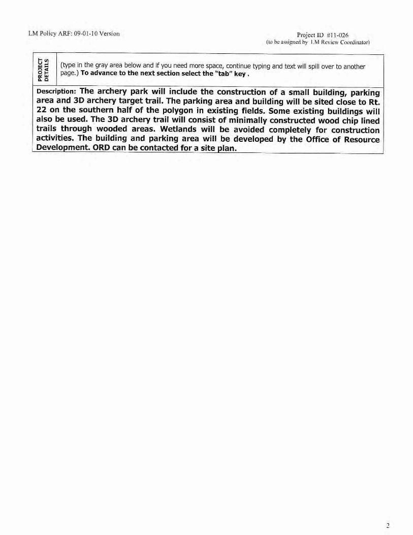
COMMUNITY ARCHERY PARK
Submitted by:
LAN Associates, Engineering, Planning, Architecture, Surveying, Inc. 445 Godwin Avenue
Midland Park, NJ 07432 (201) 447-6400- Telephone (201) 447-1233- Facsimile
NJDEP Division of Fish and Wildlife, Community Archery Park Environmental Assessment
Environmental Assessment LAN Associates, EPAS, Inc. LAN Job #2.3397.124
Table of Contents
Section No. Title Page No.
1.0 Purpose and Need for Action ....................................................................................... 1
1.1 Background ............................................................................................................... 1
1.2 Siting Considerations ................................................................................................. 2
1.3 Laws, Directives and Goals ....................................................................................... 2
1.4 Issues, Concerns and Opportunities .......................................................................... 3
2.0 Public Scoping ............................................................................................................... 4
3.0 Alternatives .................................................................................................................... 4
3.1 Alternative Site Analysis Criteria ................................................................................ 4
3.2 Alternative Site Descriptions ...................................................................................... 5
3.3 Alternative Site Analysis ............................................................................................ 7
3.4 Preferred Alternative .................................................................................................. 8
3.5 Site Design Alternatives ............................................................................................. 8
4.0 Affected Environment .................................................................................................... 8
4.1 Existing Conditions .................................................................................................... 8
4.2 Public Access ............................................................................................................ 9
4.3 Available Acreage and Compatible Land Use ............................................................ 9
4.4 Recreational Use Conflicts ........................................................................................ 9
4.5 Preservation/ Planning Areas .................................................................................. 10
4.6 Vegetation/Habitat Disturbance ............................................................................... 10
4.7 Wetlands and Vernal Pools ..................................................................................... 10
4.8 Threatened, Endangered and Rare Species ............................................................ 11
4.9 Historic and Cultural Resources .............................................................................. 11
4.10 Topography ........................................................................................................... 11
4.11 Streams and Flood Plains ...................................................................................... 11
4.12 Soil ........................................................................................................................ 12
4.13 Sewer Service Area ............................................................................................... 12
5.0 Environmental Consequences .................................................................................... 13
5.1 No Action ................................................................................................................. 12
NJDEP Division of Fish and Wildlife, Community Archery Park Environmental Assessment
Environmental Assessment LAN Associates, EPAS, Inc. LAN Job #2.3397.124
5.2 Black River WMA, Chester Township, Morris County .............................................. 13
5.3 Berkshire Valley WMA, Roxbury Township, Morris County ...................................... 13
5.4 Rockaway Creek WMA, Readington Township, Hunterdon County ......................... 13
5.5 Environmental Impacts ............................................................................................ 14
5.6 Environmental Impact Summary .............................................................................. 14
6.0 Conclusions and Recommendations .......................................................................... 16
NJDEP Division of Fish and Wildlife, Community Archery Park Environmental Assessment
Environmental Assessment LAN Associates, EPAS, Inc. LAN Job #2.3397.124
Table of Contents (continued)
Figure Title 1 Activity Review Form (ARF) 2 Boundary Survey Prepared by Bohren and Bohren Associates, Inc. 3 Readington Township Tax Map 4 Readington Township Zoning Map, 2009 5 GeoWeb/GIS Sewer Service Map 6 USDA NRCS Soil Map 7 GeoWeb/GIS Freshwater Wetlands Map 8 GeoWeb/GIS Vernal Pools and Habitat Map 9 GeoWeb/GIS Landscape Project 3.0 Streams Map 10 FEMA Flood Insurance Rate Map 11 List of Potential Threatened, Endangered, & Species of Greatest Concern 12 USGS Raritan Quadrangle Map 13 GeoWeb/GIS National Heritage Map 14 Transportation Corridor Map 15 Proximity to Schools Map 16 Qualifications of Preparer Appendix Title 1 Captioned Photographs 2 Letter Report Prepared by Richard Grubb & Associates, Inc.
NJDEP Division of Fish and Wildlife, Community Archery Park Environmental Assessment
Environmental Assessment LAN Associates, EPAS, Inc. LAN Job #2.3397.124
1.0 Purpose and Need for Action:
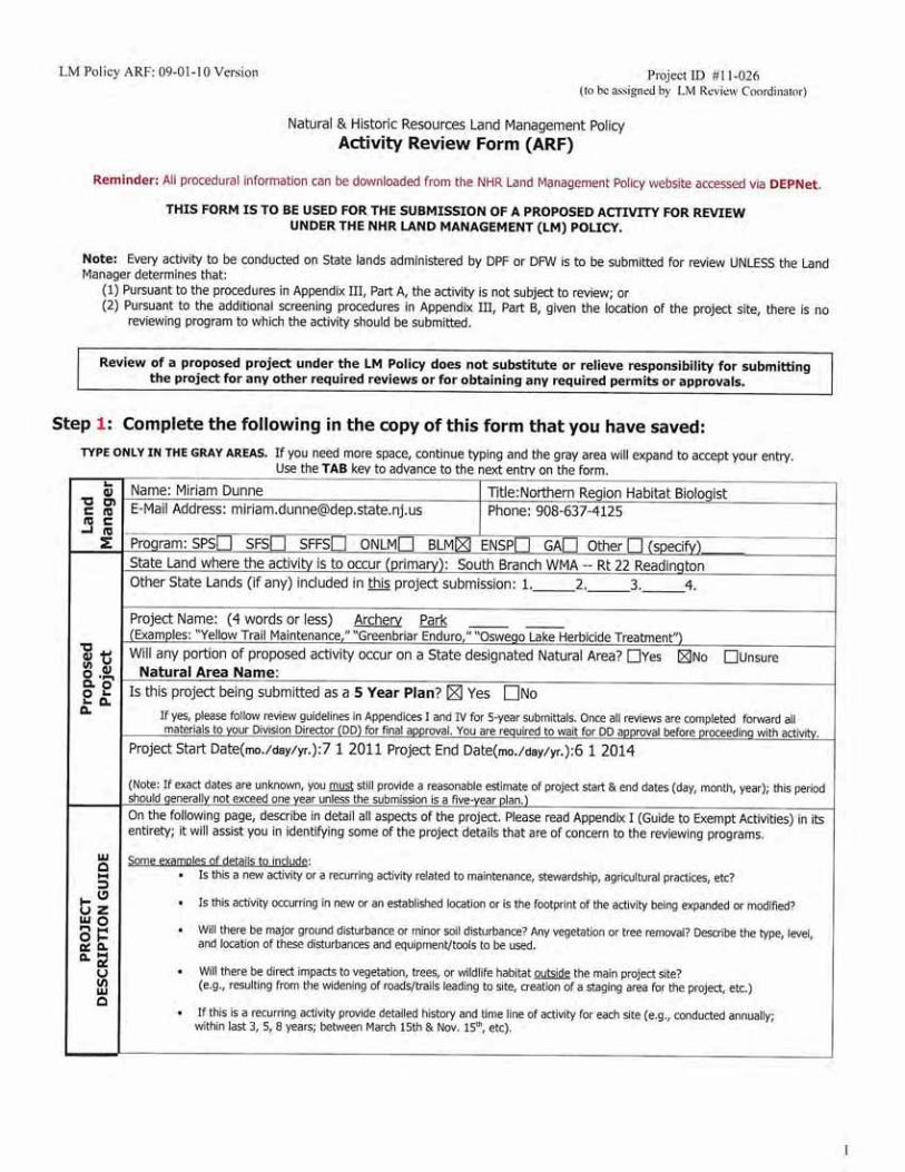
The New Jersey Division of Fish and Wildlife, hereafter Division, has commissioned LAN Associates, Engineering, Planning, Architecture, Surveying, Inc. (LAN) to conduct an environmental assessment of potential impacts related to the Division’s need to develop a regional Community Archery Park for the purpose of providing enhanced bow hunter education programs and recreational archery shooting opportunities to the general public. The Division currently does not own or operate a dedicated facility for bow hunter education and recreational archery shooting programs. The Division, as part of its Wildlife Management Area system, owns and manages twelve outdoor archery ranges. The Division currently has no dedicated indoor archery facility available to the public nor do all of the Division’s existing outdoor ranges have covered shooting stations or classrooms associated with them. As a consequence, the Division must suspend bow hunter education programs during the winter months, November through March, because inclement weather precludes hunter education staff from offering practical live-fire exercises on uncovered ranges. The same holds true for recreational archers who wish to improve their marksmanship skills. The lack of a dedicated indoor and outdoor shooting facility limits the ability of the Division to meet hunter education and recreational shooting demand. The Division recognizes the importance and benefit of participating in the National Archery in the Schools Program (NASP). New Jersey is a participating member in NASP and is seeking to expand participation in program from fourteen to one hundred schools. A study conducted by the Archery Trades Association in 2011 found that making archery and archery programs more accessible in metropolitan areas had the potential for producing higher returns in participation for every dollar programs invested. The development of a Community Archery Park will meet the Division of Fish and Wildlife’s need for action to increase participation in the NASP program. The Division receives substantial funding for its activities through the Federal Aid in Wildlife Restoration Program. Program funds are generated through the collection of excise taxes on firearms, ammunition, and archery equipment by hunters and recreational shooters. In recognition of the user-pay/user-benefit nature of the program the Division of Fish and Wildlife believes it is appropriate to enhance opportunities for bow hunter education and archery related recreation by developing two dedicated year round indoor/outdoor Community Archery Parks in the northern and southern regions of the state.
1.1 Background
The education and training of bow hunters in New Jersey began in 1958 with the passage of Public Law 23:3-7.1 which requires the Division to provide instruction to new hunters in bow and arrow safety and proficiency before obtaining their initial bow and arrow hunting license. The Division recognizes the importance of bow hunting in achieving wildlife management objectives in the most densely populated state in the country and the cultural and economic contributions hunters have made to New Jersey’s bow hunting tradition. The Division further recognizes the role recreational archery shooting opportunities and the National Archery in the Schools Program plays in increasing participation in archery related activities. Since 2008 the Division of Fish and Wildlife has enrolled 50 schools in NASP. Over ten thousand students participate in NASP annually, and consistent with the amendment to The Federal Aid in Wildlife Restoration Act, the Division has used federal funds to develop and enhance archery education and safety programs and archery training ranges.
NJDEP Division of Fish and Wildlife, Community Archery Park Environmental Assessment
Environmental Assessment LAN Associates, EPAS, Inc. LAN Job #2.3397.124
1.2 Siting Considerations
The need for a Community Archery Park located in northern New Jersey has been established above. The Community Archery Park will be located on property under the administration of the Division where there will be no conflict with established fish and wildlife activities and where impacts to fish and wildlife populations and habitats will be minimized. The range facilities will be regionally located to maximize exposure of archery programs to the greatest number of public schools within a sixty minute drive of the proposed project site and near major transportation corridors to provide hunters and the general public from large population centers easy access to archery shooting opportunities. The site shall be at least thirty two acres in size and within a developable region that will accommodate the scope of the Community Archery Park project. The counties of primary interest in the northern region of New Jersey are Hunterdon and Morris.
1.3 Laws, Directives and Goals
State law requires new bow hunters must receive training and safety instruction prior to licensure. The purpose and need for the proposed Community Archery Park is consistent with the interest and regulatory responsibility of the New Jersey Division of Fish and Wildlife to provide training and recreational shooting opportunities to the general public. The following is a list of goals the proposed project wishes to accomplish: 1. To provide a safe functional facility with indoor archery ranges and classroom/storage
space for year round and walk-in bow hunter education instruction.
2. To provide a safe and functional indoor archery facility for year round public recreational shooting opportunities, archery equipment safety programs, and other live-fire events.
3. To provide a safe functional 90 meter outdoor archery field course and 3-D course that
permits bow hunter education field instruction and long range recreational and competitive shooting opportunities.
4. To provide classroom and office space that will support the Division’s goal of increasing
NASP participation by 30 schools and 3000 students per year. 5. To provide a location for outreach programs that promote bow hunter education, increases
public awareness of the benefits of bow hunting and introduces new participants to the benefits of target and recreational archery shooting.
6. To develop public/private partnerships to support the development, operations, and
maintenance of the Community Archery Park. 1.4 Issues, Concerns and Opportunities
Provide a facility to address the needs of the public that is consistent with the laws, directives and goals above. A proposed facility site will be deemed suitable based on the following characteristics:
Ownership- Property on which facility will be sited must be under ownership and administration of the New Jersey Division of Fish and Wildlife
Proximity to Schools- Facility must be sited within sixty minute drive of 500 or more public schools to maximize exposure to DFW’s NASP program
NJDEP Division of Fish and Wildlife, Community Archery Park Environmental Assessment
Environmental Assessment LAN Associates, EPAS, Inc. LAN Job #2.3397.124
Public Access- Proximity to major roads & population centers- The project site should be located near a transportation corridor affording the general public the most convenient accessibility to the facility.
Preservation/Planning Areas- The proposed site should be located on property that is easily developed and not subject to the regulatory framework of preservation or planning areas.
Available Acreage & Compatible Land Use- The project site should be at least thirty
two acres in size and be situated at least ½ mile from schools and residential dwellings.
Risk of Recreation Use Conflicts- The site should be located on property where interference with other types of fish and wildlife activities will be minimized.
Vegetation/Habitat Disturbance- The site should be located on previously modified
property that requires minimal excavation, vegetation removal, or habitat disturbance.
Wetlands and Transition Areas- The site should be located away from wetland areas.
Threatened & Endangered Species- The project site should be located on property with a low likelihood of threatened or endangered species presence.
Historic & Archeological Resources- The project site should be located on property
that has cultural or historical significance.
Topography-The project site should be located on flat to gently rolling terrain.
Streams and Riparian Areas- The project site should be located away from stream and riparian areas.
Soil Classification- The project site should be located on property with well-drained soil
types
Sewer Service Availability- Location of project site within an area served by public sewer system would be preferable.
Following the completion of the regional feasibility studies and environmental assessments, the Division, working through the NJ Department of Environmental Protection’s Office of Engineering and Construction, will contract with a professional engineer to develop facility and site plan designs for the selected locations for the Community Archery Parks. During this phase the Division will seek out and enter into agreements with other public and private entities for maintenance and operational support. The Division has already approached potential partners that have expressed strong interest in contributing to the development, operation, and maintenance of the Complex. After selection of a facility and site design that will meet the stated objectives and goals of this project, the Division, working through the NJ Department of Environmental Protection’s Office of Engineering and Construction, will contract with a professional construction company to build a facility approximately 15,000-25,000 square feet in size. The facility will include space for an indoor archery range, approximately 25 meters long, with eight to ten shooting lanes, a multi-purpose/classroom, office space for Division and partner group personnel, storage space and lavatory facilities. The contractor will develop an archery field course, approximately 90 meters in length, and a 3-D target course.
The Community Archery Park should be able to meet the goals listed above in Section 1.3.
NJDEP Division of Fish and Wildlife, Community Archery Park Environmental Assessment
Environmental Assessment LAN Associates, EPAS, Inc. LAN Job #2.3397.124
2.0 Public Scoping:
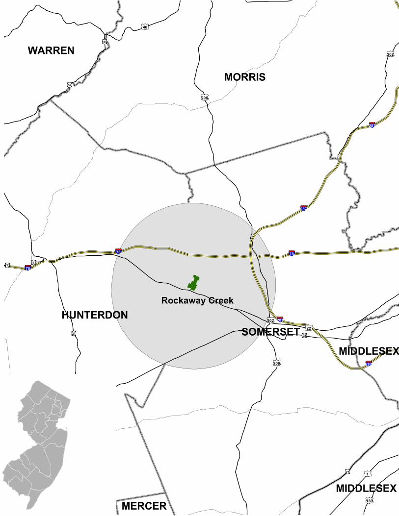
The Division of Fish and Wildlife will post the Community Archery Park Environmental Assessment to the Division’s website for view prior to any scheduled public meeting. Following a period of not less than thirty days, the Division will schedule one public meeting to accept oral and written comments from the general public on the proposed Community Archery Park project. The meeting will be held at the Division’s Pequest Natural Resource Education Center which is regionally located near the three proposed project sites of Berkshire Valley WMA (17.36 miles), Black River WMA (15.08 miles), and Rockaway Creek WMA (19.69 miles). Notice of the public meeting will be advertised in the Star Ledger, New Jersey’s largest newspaper, which circulates in all areas near the three proposed project sites.
3.0 Alternatives: For the purpose of this report a total of three (3) sites were selected and analyzed based on their location and potential to support the proposed project. All sites analyzed are Wildlife Management Areas (WMA) owned by the State of New Jersey and administered by the Division of Fish and Wildlife’s Bureau of Land Management. Each site was selected by the NJDEP and provided to LAN for inclusion in the analysis. A no-action alternative was also considered as part of the analysis. A selection of the no-action alternative would not support the development of a facility for hunter education. Furthermore, a no-action alternative would not support the development of safe and responsible hunter behavior and good marksmanship skills. Therefore, the no-action alternative was dismissed from further consideration because it does not address any of the needs described above.
3.1 Alternative Site Analysis Criteria:
The criteria established for site analysis and evaluation was determined based on the issues outlined in section 1.4 above. Following site specific analysis, these criteria will serve as a basis for ranking the feasibility of each site to support the proposed development. CRITERIA Ownership
Good- publically owned and administered by the NJ Fish and Wildlife Poor- private or public ownership and not under administration of NJ Fish and Wildlife
Proximity to Schools
Good- one hour drive or less from 500 or more schools Poor- greater than one hour drive from 500 or more schools
Public Access
Good- three or more highways or interstates within five miles of proposed site Poor- less than three highways or interstates within five miles of site.
Preservation/Planning Area Good- outside Highlands Preservation Area Poor- within Highlands Preservation Area
Available Acreage and Compatible Land Use
Good- area necessary to safely conduct activities associated with this facility, thirty two acres, situated greater than ½ mile from schools and residential properties

NJDEP Division of Fish and Wildlife, Community Archery Park Environmental Assessment
Environmental Assessment LAN Associates, EPAS, Inc. LAN Job #2.3397.124
Poor- situated within ½ mile of residential properties and/or schools, inadequate area to safely conduct activities, less than thirty two acres
Recreational Use Conflict
Good- low risk of interference with Fish and Wildlife Activities at site Poor- high risk of interference with Fish and Wildlife Activities at site
Vegetation/Habitat Disturbance
Good- recently cleared, devoid of mature trees, modified/fallow agricultural land Poor- mature forest, sensitive plant species
Wetlands and Vernal Pools
Good- project area located outside wetland or vernal pool areas Poor- project area located within wetland or vernal pool areas
Threatened and Endangered Species
Good- no significant ecological features Poor- presence of special concern, threatened and/or endangered species
Historic and Archeological Resources
Good- no or low sensitivity for prehistoric and/or historic archeological resources Poor- moderate to high sensitivity for prehistoric and/or historic resources
Topography
Good- relatively level to gently sloping Poor- steep slopes, rock outcrops
Streams and Flood Plains
Good- project area located away from streams and outside flood plains Poor- project area located near streams and/or within flood plains
Soil Classification
Good- well drained soils Poor- poorly drained soils
Sewer Service Area
Good- located within a sewer service area (SSA) as shown on the NJDEP iMap. Poor- located outside a sewer service area (SSA) as shown on the NJDEP iMap.
3.2 Alternative Site Descriptions
Alternative A – No Action As described in section 3.0, the no-action alternative was deemed to be non-responsive to the needs of hunters and the general public and was dismissed from further consideration. Alternative B – Black River WMA, Chester Township, Morris County In 2007-2008, the NJDEP explored the possibility of constructing a Community Archery Park at Black River WMA, a state owned facility operated by the NJ Division of Fish and Wildlife. The Black River WMA is located 2.6 miles east of US Highway 206 and 5 miles south of US Highway 46 within a sixty minute drive of 1,133 public schools that would provide 619,215 students with access to archery and bow hunter education programs.
NJDEP Division of Fish and Wildlife, Community Archery Park Environmental Assessment
Environmental Assessment LAN Associates, EPAS, Inc. LAN Job #2.3397.124
Encompassing approximately 3,080 acres, the Black River WMA is part of the Division’s Wildlife Management Area system and is open to the general public for hunting and fishing related activities. The WMA is stocked with pheasants during November and December to enhance small game hunting opportunities. Wildlife viewing and hiking is also permitted on the property. In addition, Black River offers for public use a hunter training range which includes outdoor handgun and shotgun ranges as well as an outdoor archery range. There is a moderate risk that the Community Archery Park would impact existing activities.
Located in the Highlands Preservation Area, the Black River WMA is comprised primarily of forested and emergent wetlands, streams, modified agricultural fields and upland mixed hardwood forest. The proposed project site consists of fallow agricultural fields, with well drained soils, that slope from northwest to southeast resulting in little disturbance to wildlife habitat. Significant excavation would be required to develop the site. Wetlands are present along the southeast border of the proposed project location, and development in this section of the Highlands Preservation Area will require additional permits and approval from the New Jersey Department of Environmental Protection (NJDEP). According to Version 3 of the New Jersey Landscape Project, developed by the New Jersey Division of Fish and Wildlife’s Non-Game and Endangered Species program, the proposed site is valued for such species as the Wood Turtle (state threatened), Barred Owl (state threatened), Red-Shouldered Hawk (state endangered), and Veery (special concern). The Natural Heritage Grid created by NJDEP did not identify any rare plant species or rare ecological communities at the proposed project site. According to NJDEP’s historic/archeological grid, there are no historically or culturally significant resources located near the proposed project site. The proposed project site is not located in a sewer service area and construction of a facility at this location would require installation of a septic field. Alternative C – Berkshire Valley WMA, Roxbury Township, Morris County The proposed site under consideration for Alternative C is situated along Howard Boulevard in Roxbury Township, Morris County and is part of the Berkshire Valley Wildlife Management Area. Berkshire Valley WMA is owned and maintained by NJ DFW and is located .75 miles north of Interstate Route 80, 2.05 miles north of US Highway 46, and 4.36 miles from US Highway 206. The proposed site is within a sixty minute drive of 1,065 schools that would provide 575,796 students with access to archery and bow hunter education programs. As part of the NJ DFW Wildlife Management Area system, the Berkshire Valley WMA comprises 2,030 acres and is open to the general public for hunting and fishing related activities. Berkshire Valley is stocked with pheasants during November and December to enhance small game hunting opportunities. Other permitted activities include wildlife viewing and hiking. Located in the Highlands Preservation Area, the Berkshire Valley WMA consists of steep slopes and rock outcroppings. The habitat found on the WMA is primarily comprised of mature mixed hardwood forest and wetlands. The proposed project site is located along Howard Boulevard adjacent to an existing gravel parking lot in a well-drained undisturbed area with mature trees. Existing habitat would be impacted as a significant number of trees would need to be removed to prepare the site for construction. Development in this section of the Highlands Preservation Area will require additional permits and approval from the NJDEP. According to Version 3 of the New Jersey Landscape Project, developed by the New Jersey Division of Fish and Wildlife’s Non-Game and Endangered Species program, the proposed site is valued for such species as the Indiana Bat (federally listed), Barred Owl (state threatened), and Red Shouldered Hawk (state endangered). The Natural Heritage Grid created by NJDEP did not identify any rare plant species or rare ecological communities at the proposed project site.
NJDEP Division of Fish and Wildlife, Community Archery Park Environmental Assessment
Environmental Assessment LAN Associates, EPAS, Inc. LAN Job #2.3397.124
According to NJDEP’s historic/archeological grid, the proposed project site falls within a cell indicating the presence of an archaeological site that may be included in the New Jersey or National Registers of Historic Places, has been determined eligible for inclusion through federal or state processes administered by the New Jersey Historic Preservation Office (HPO), or has been identified through a cultural resource survey or other documentation on file at the HPO. According to a Sewer Service Area GIS layer created by NJDEP, the proposed project site is located in a no discharge area. Alternative D – South Branch WMA, Rockaway Creek Section, Readington Township,
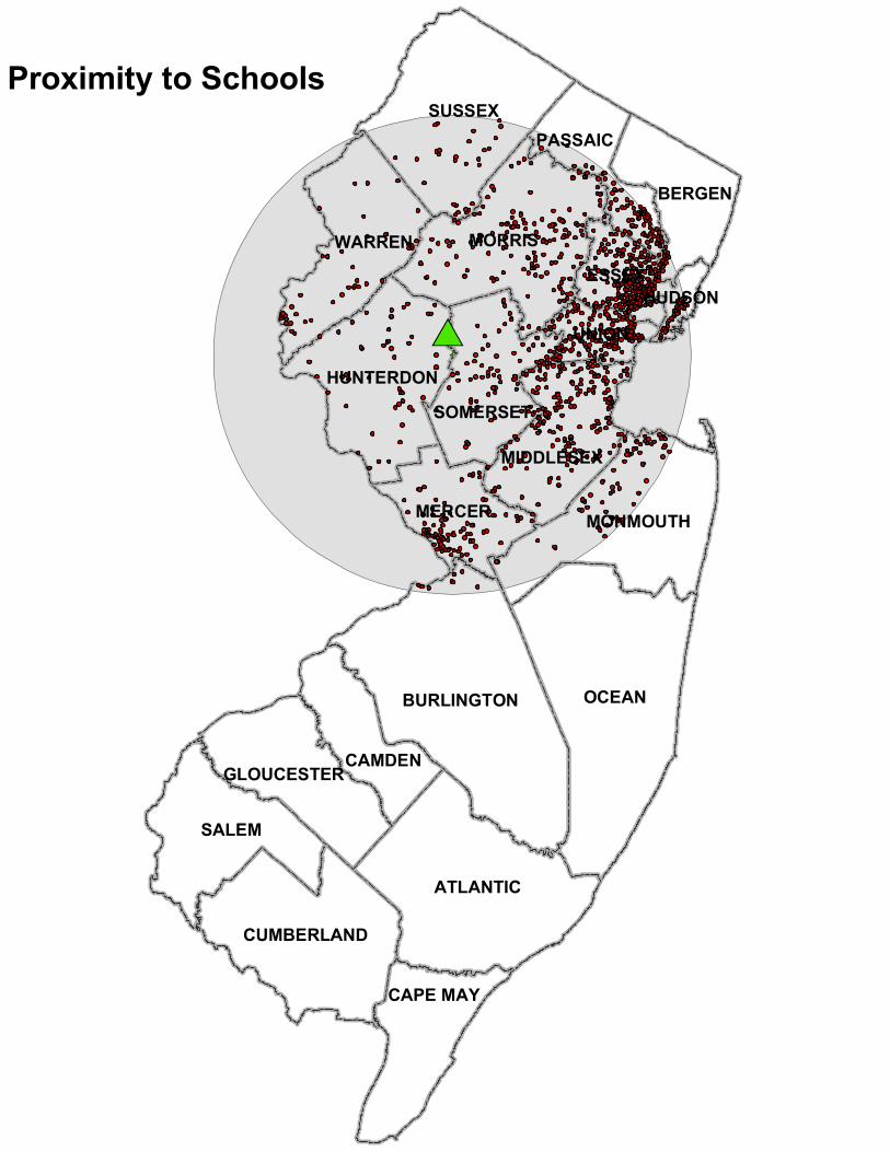
Hunterdon County The proposed site under consideration for Alternative D is located in Readington Township, Hunterdon County on a 228 acre tract of land known as Rockaway Creek section, hereafter Rockaway Creek, of the South Branch Wildlife Management Area system. Rockaway Creek is conveniently located .5 miles north of US Highway 22, 2.1 miles south of Interstate Route 78, 5.2 miles north of US Highway 202, and 4.8 miles west of Interstate Route 287. The proposed site is located within a sixty minute drive of 1,295 schools providing 710,061 students with access to archery and bow hunter education programs. Hunting and fishing opportunities at the proposed site are limited. The property is used primarily by deer hunters, and although small game hunting opportunities exist, the proposed site is not included in the Division’s pheasant stocking program. There are no hiking trails or wildlife viewing stations located on the property. Located in the Piedmont region of New Jersey, and within an agricultural/residential zoning district, the proposed site is characterized as a previously working farm interspersed with fallow agricultural fields and small woodlots. Rockaway Creek is not encumbered by wetlands or suitable habitat for any federally listed threatened or endangered species. Topography in the fallow agricultural field is relatively level and it is anticipated that soil disturbance associated with grading activities would be minimal compared to the alternatives. There is an existing gravel road for access to the interior of the property, and although currently disconnected, power lines are present along the roadway.
3.3 Alternative Site Analysis
Criteria Alternative A Alternative B Alternative C Alternative D
No-Action Black River WMA
Berkshire Valley WMA
Rockaway Creek
Ownership No-Action Good Good Good Proximity to
Schools No-Action Good Good Good
Public Access No-Action Poor Good Good Highlands Area No-Action Poor Poor Good
Available Acreage & Compatible Land
Use No-Action Good Good Good
Recreational Use Conflict No-Action Poor Poor Good
Vegetation/Habitat Disturbance No-Action Good Poor Good
NJDEP Division of Fish and Wildlife, Community Archery Park Environmental Assessment
Environmental Assessment LAN Associates, EPAS, Inc. LAN Job #2.3397.124
Wetlands & Vernal Pools No-Action Poor Poor Good
Threatened & Endangered
Species No-Action Poor Poor Poor
Historic & Archeological
Resources No-Action Good Poor Good
Streams & Flood Plains No-Action Poor Good Good
Soil Classification No-Action Good Good Poor Sewer Service
Areas No-Action Poor Poor Good
3.4 Preferred Alternative
The preferred alternative (Alternative D) achieved a rank of “Good” for eleven (11) of the thirteen (13) site analysis criteria. This location, Rockaway Creek appears to be the most feasible and least likely location to incur adverse environmental impacts from this development.
3.5 Site Design Alternatives
Alternatives to locating the improvements at the Rockaway Creek WMA include no action, development of the facility at the Black River WMA and development of the facility at the Berkshire Valley WMA. Based on the results of the alternative site analysis above the Rockaway Creek WMA is the most suitable location for the Community Archery Park.
4.0 Affected Environment:
As described in the alternatives analysis above, the preferred site is Rockaway Creek WMA. This section of the report will focus on the existing conditions present at the site including its environmental characteristics. As part of the research process LAN utilized the NJDEP’s GeoWeb interactive Geographic Information System (GIS) to obtain a variety of information about the subject parcel. The information acquired includes but is not limited to mapped wetland areas, regulated streams, sewer service availability maps and other land use characteristics encumbering the project area. The GeoWeb has also incorporated the Landscape Project Version 3.0 layers into its system which provide information on the presence or absence of suitable habitat for endangered, threatened or species of special concern. All information obtained from this GIS source will be referenced as GeoWeb.
4.1 Existing Conditions
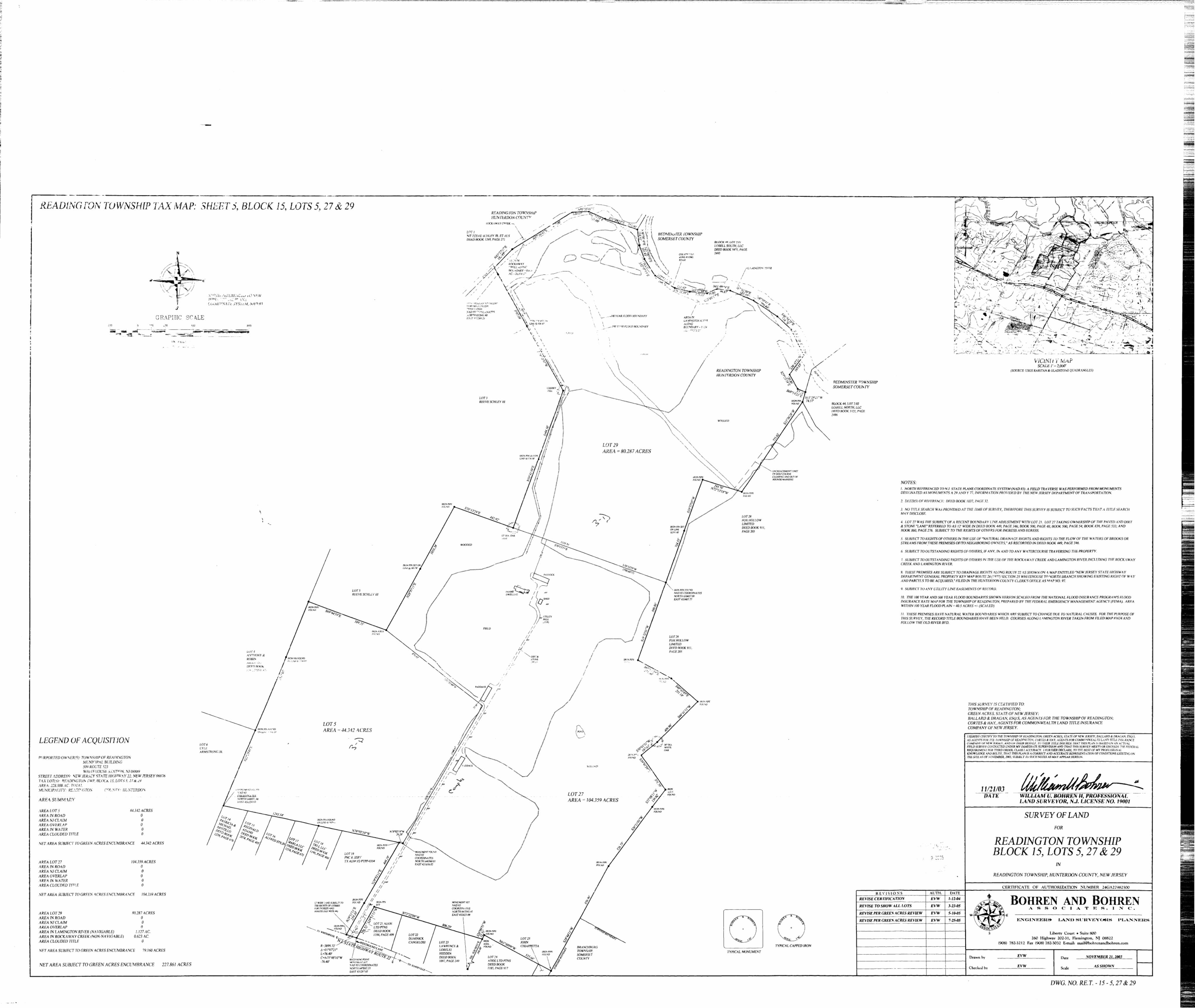
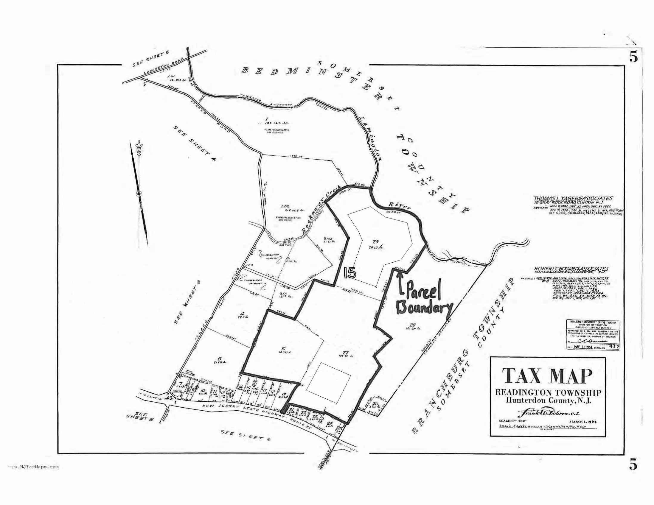
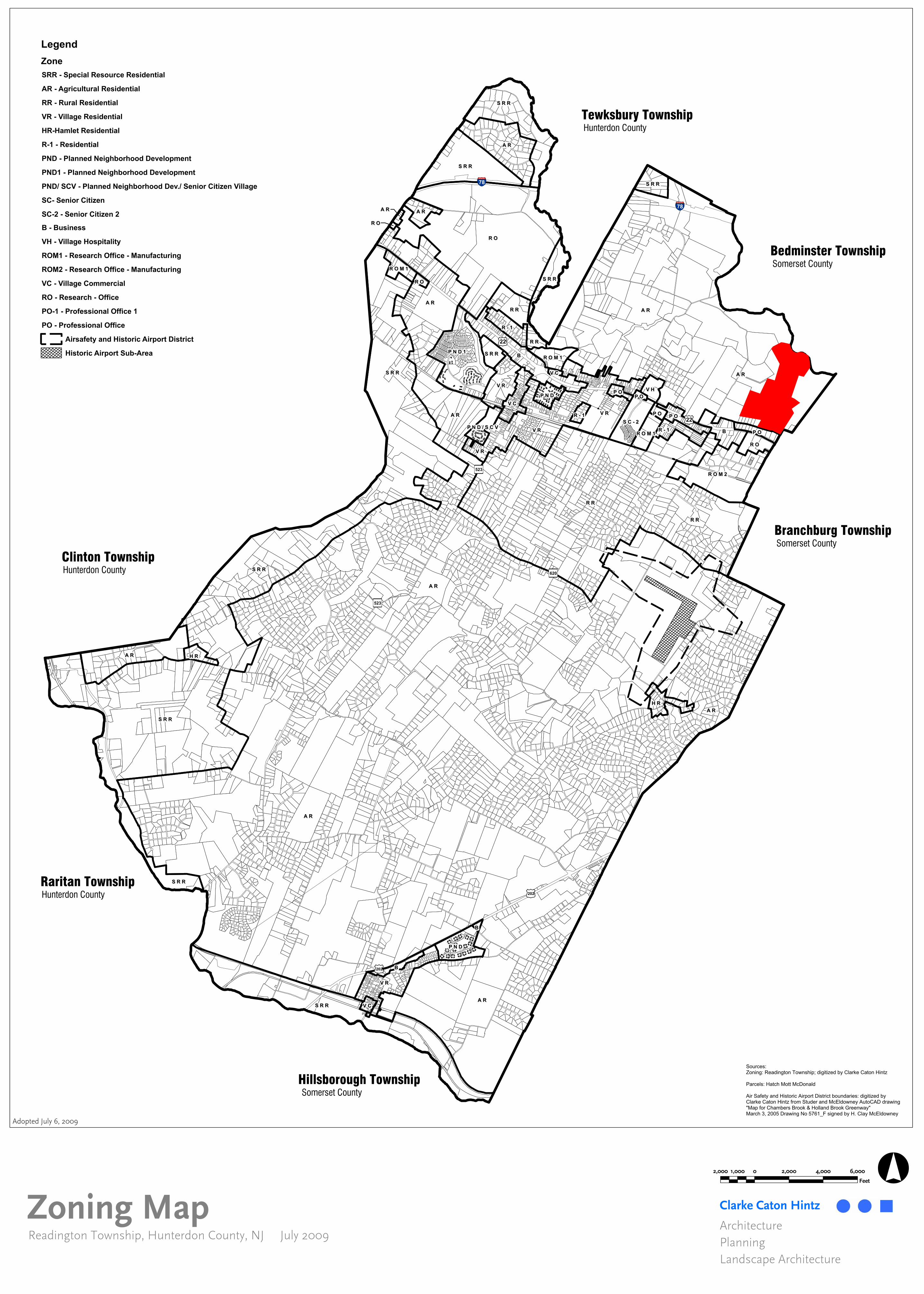
The subject parcel, referred to as Rockaway Creek, is owned by the NJDEP and managed and maintained by the NJ Division of Fish and Wildlife. The parcel, part of the larger South Branch WMA system, contains approximately 228 acres and is comprised of three tax lots located in Readington Township, Hunterdon County, New Jersey and is subject to Green Acres encumbrance. A copy of a boundary survey entitled “Survey of Land for Readington Township Block 15, Lots 5, 27 & 29” prepared by Bohren and Bohren Associates, Inc. dated November 21, 2003 last revised July 25, 2005 is included as Figure 2 for reference. A copy of the Readington Township tax map is included as Figure 3 for reference. According to the Readington Township Zoning Map (see Figure 4) the parcel is located within an Agricultural Residential (AR) zone.
NJDEP Division of Fish and Wildlife, Community Archery Park Environmental Assessment
Environmental Assessment LAN Associates, EPAS, Inc. LAN Job #2.3397.124
The parcel is bordered on the south by existing commercial properties and U.S. Route 22, on the east by an existing golf course, on the west by commercial and agricultural land and on the north by the Rockaway Creek and Lamington River. The property can be accessed via a paved and dirt driveway off of the westbound side of U.S. Route 22 located approximately 2,500 feet east of the intersection with Island Road. The site has an existing electrical service from a utility pole on the north side of U.S. Route 22. Additional utility poles are stationed along the access drive into the site. However at the time of LAN’s site visit the electrical service had been shut off due to line damage incurred during an October winter storm. The indoor archery range, classroom building, and outdoor archery event fields, identified as Site A, will be located on the project area in a portion of the subject parcel located primarily within a fallow agricultural field to the east of the access drive approximately 1,000 feet north of Route 22. An old wood frame paddock approximately 3,600 square feet (sf) exists in the northwest corner of the agricultural field. The 3-D bow hunter education competitive archery field course will be located approximately 2,800 feet north of Route 22 within a portion of Block 15 Lot 29, identified as Site B, is approximately eighty acres in size of which fifty eight are wooded and twenty two are fallow.
4.2 Public Access
Rockaway Creek WMA can be accessed from the westbound lane of U.S. Route 22, located approximately 2,500 feet east of the intersection of Island Road. The project area can be accessed via a paved and dirt driveway and is located to the east of the drive in a fallow agricultural field approximately 1,000 feet north of Route 22. This parcel is ideally located within 2.1 miles of Interstate Route 78, 5.2 miles of US Highway 202, and 4.8 miles of Interstate Route 287. This location is within a sixty minute drive of the general public living completely in or portions of 14 counties in the state of New Jersey. The proposed site would provide 710,061 students from 1,295 schools access the archery related activities. The indoor facility will be open all year and accessible to all persons for archery related and bow hunter education programs. The practical component of the bow hunter education course will be offered year round on a walk-in basis offering the general public increased opportunity to participate in bow hunter education programs.
4.3 Available Acreage and Compatible Land Use
The existing cleared fallow agricultural field contains approximately 12 acres of land and is within the proposed project area. An approximate 600 foot wooded buffer exists between the proposed project area and the adjacent property boundary. This amount of land is sufficient to safely conduct the proposed activities based on the current plan of development. The 80 acre parcel selected for Site B has ample room to conduct 3-D archery activities. Approximately 15-20 acres will be required to develop Site B. In addition the project area is not located within ½ mile of any residential properties or schools.
4.4 Recreational Use Conflicts The proposed site currently offers limited hunting opportunities. The site is primarily used by deer hunters and the size of the proposed site keeps hunter density at a minimum. As stated
NJDEP Division of Fish and Wildlife, Community Archery Park Environmental Assessment
Environmental Assessment LAN Associates, EPAS, Inc. LAN Job #2.3397.124
previously, Rockaway Creek is not included in the Division’s pheasant stocking program and as such there is a low risk of conflict with existing activities.
4.5 Preservation/Planning Areas
The Highlands Water Protection and Planning Act N.J.A.C. 7:38, established rules which regulate activities within the Highlands Preservation Area. The Act also includes provisions for the protection of the Highlands Planning Area however conformance with the Planning Area regulations is voluntary and dependent on the county or municipality to revise their master plans to be in conformance with the Highlands Regional Master Plan.
As per GeoWeb, the parcel and project area are located outside both the Highlands Protection and Planning Areas.
4.6 Vegetation/Habitat Disturbance
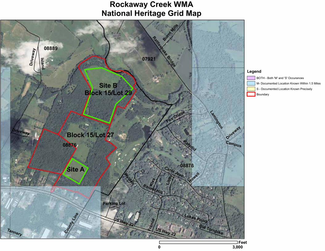
The fallow agricultural field located within the project area is outlined by a post and wire fence along its perimeter and is dominated by herbaceous vegetation including grasses, sedges and wildflowers. A few autumn olive (Elaeagnus umbellata) and multiflora rose (Rosa multiflora) shrubs are scattered throughout the field. The wooded area is dominated by both hard and softwood tree species. Dominant hardwood species include sassafras (Sassafras albidum) and red maple (Acer rubrum). Some pin oak (Quercus palustris) and white oak (Quercus alba) are interspersed throughout the wooded area. The dominant softwood species is eastern red cedar (Juniperus virginiana) and can be found throughout the wooded area. A few white pine (Pinus strobus) are present along the forest edges. The understory of the forested area is not well developed and consists primarily of wine raspberry (Rubus phoenicolasius) along the forest margins and also within the forest where the canopy is open. The Natural Heritage Grid Map layer on GeoWeb was also searched for the presence or absence of rare plant communities near the project area. Figure 13 is a GeoWeb produced map which includes the documented locations of rare plant community grids within 1.5 miles of the project area. The project area does not intersect with any documented location of rare plant communities as shown per GeoWeb.
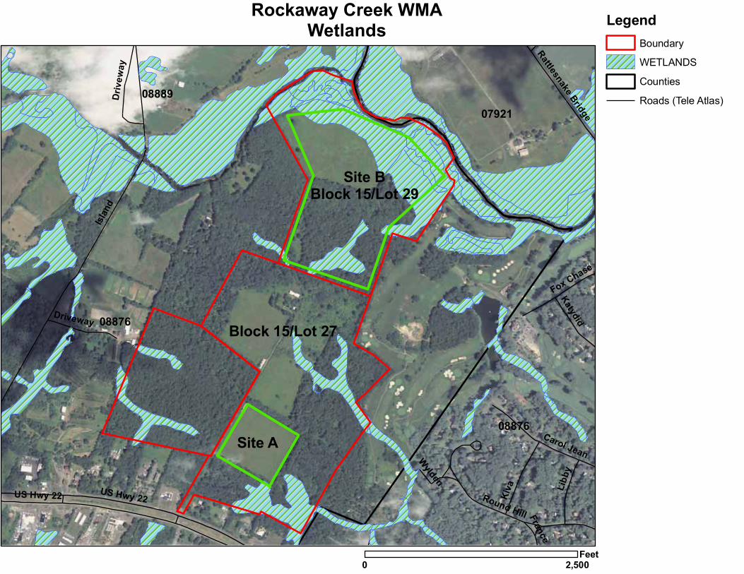
4.7 Wetlands and Vernal Pools According to GeoWeb, wetlands are present within a wooded area to the southeast of the agricultural field (see Figure 7). The same map shows a thin wetland area generally reaching in an easterly/westerly direction located throughout the southern portion of the wooded area. A smaller wetland area is depicted in the westerly portion of the wooded area located near the midpoint of the westerly boundary line of lot 5. Each of these wetland areas are referred to as deciduous wooded wetlands according to NJDEP’s GeoWeb. Additional wetland areas are shown within the parcel limits to the north in the area of the proposed project site where the 3-D course would be. Any disturbance in this area would be relegated to removal of only that vegetation which is necessary to insure the safety of the shooters on the course including, but not limited to, low hanging branches, deadfalls and low shrubby growth. Effort will be made to avoid riparian buffers along the boundary of the designated wetlands and any development of walking trails between the shooting stations will be constructed of pervious materials such as wood chips. The wetland area nearest the project area not described above is approximately 500 feet north from the northeasterly corner of the agricultural field. Disturbance to any of these wetlands
NJDEP Division of Fish and Wildlife, Community Archery Park Environmental Assessment
Environmental Assessment LAN Associates, EPAS, Inc. LAN Job #2.3397.124
and/or their associated transition areas would be regulated by the NJDEP’s Freshwater Wetlands Protection Act Rules N.J.A.C. 7:7A. The parcel was also searched for the presence or absence of vernal habitat area or potential vernal habitat area. Figure 8 is a copy of the parcel and surrounding neighborhood which includes potential vernal habitat per the NJDEP’s GeoWeb Landscape Project 3.0 Vernal Habitat layer. As shown on the map a potential vernal habitat area exists approximately 1,500 feet northwest of the northwestern most corner of the project area.
4.8 Threatened, Endangered and Rare Species
As mentioned above, LAN has received a list of potential threatened, endangered and special concern non-game species that may be found at the subject site from Mr. Robert Longcor, NJDFW. Figure 11 is a copy of this document. According to the document there are no species of concern in the project area as shown on the NJDEP’s GeoWeb Landscape Project Version 3.0. LAN also performed research of GeoWeb files and concurs with these results. According to the document the most recent Species Occurrence Area file was also searched. This search revealed that the project area intersects with one (1) Upland Sandpiper (NJ State Endangered) breeding sighting, four (4) Great Blue Heron (NJ Special Concern) foraging and one (1) Eastern Box Turtle (NJ Special Concern) occupied habitat.
4.9 Historic and Cultural Resources
LAN commissioned Richard Grubb & Associates, Inc. to perform an archaeological screening of the project area. Appendix 2 is a copy of the complete letter report prepared by Richard Grubb & Associates, Inc. dated December 23, 2011. The conclusion of this report indicates that no known archaeological constraints were identified during background research. The project area was assessed as having a moderate sensitivity for prehistoric resources and a low to moderate sensitivity for historic resources (Paul J. McEachen, MA, RPA, Richard Grubb & Associates, Inc., Archaeological Screening Report, December 23, 2011).
4.10 Topography
The project area is generally located at a high point which is situated on a large terrace in the landscape. Topography in the project area is relatively flat and slopes gently downhill to the northwest and southeast. Figure 12 is a copy of the USGS Raritan Quadrangle map with both the parcel boundary and project area indicated.
4.11 Streams and Flood Plains
Two (2) streams traverse the northern boundary of the parcel and are commonly referred to as the Rockaway Creek and the Lamington River. The Lamington River is considered Category One water by the NJDEP whereas the Rockaway Creek is not. Category One waters receive the greatest level of protection under the NJDEP’s Flood Hazard Area Control Act Rules N.J.A.C. 7:13 which governs disturbance to the waterway and/or its associated riparian zone. Although the Rockaway Creek is a tributary to the Lamington River, it is not located within the same sub-watershed hydrologic unit code (HUC) as the Lamington River and would not be afforded the same level of protection. Both streams are a considerable distance away from the project area. The portion of the project area nearest either of these streams is in the northwest corner of lot 5 which is located approximately 2,000 feet south of the Rockaway Creek. However, an unnamed tributary to the Rockaway Creek is located approximately 300 feet west of the midpoint of the westerly boundary line of lot 5. Figure 9 includes a copy of the parcel and surrounding neighborhood which includes
NJDEP Division of Fish and Wildlife, Community Archery Park Environmental Assessment
Environmental Assessment LAN Associates, EPAS, Inc. LAN Job #2.3397.124
the streams described above per the NJDEP’s GeoWeb Landscape Project 3.0 Streams layer. Disturbance to any of these streams and/or their riparian zones would be governed by the Flood Hazard Area Control Act Rules N.J.A.C. 7:13. According to the National Flood Insurance Program, Flood Insurance Rate Map prepared by the Federal Emergency Management Agency (FEMA) a floodplain associated with the Rockaway Creek and Lamington River exists in the northern portion of the property (see Figure 10). Although the floodway extends onto the parcel it is located a considerable distance away from the project area. The portion of the project area nearest the floodplain is the northwest corner of the agricultural field which is located approximately 2,400 feet south of the 100 year flood boundary.
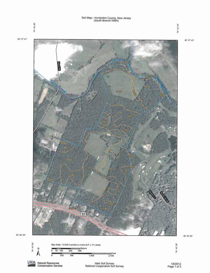
4.12 Soil
The United States Department of Agriculture (USDA) National Resources Conservation Service (NRCS) Soil Map for Hunterdon County indicates 3 mapping units present on the site. A copy of the Soil Map including a rough site outline is included in this report as Figure 6. The mapping units indicated for the site are (LbtB) Lansdowne silt loam, 2 to 6 percent slopes, (NotB) Norton loam, 2 to 6 percent slopes and (NotC2) Norton loam, 6 to 12 percent slopes, eroded. A brief description and typical profile of the mapping units is provided below.
(LbtB) Lansdowne silt loam The drainage class of the Lansdowne series is considered somewhat poorly drained. The parent material consists of fine-loamy till derived from sandstone and shale over residuum weathered from sandstone and shale. Below is a typical soil profile for this soil group:
0 to 7 inches Silt loam 7 to 13 inches Silt loam 13 to 45 inches Silty clay 45 to 60 inches Stratified sandy loam to channery silty clay 60 to 157 inches Weathered bedrock
(NotB) Norton loam, 2 to 6 percent slopes The drainage class of the Norton series is considered well drained. The parent material consists of red fine-silty till and/or colluvium. Below is a typical soil profile for this soil group:
0 to 10 inches Loam 10 to 14 inches Silty clay loam 14 to 24 inches Silty clay loam 24 to 44 inches Silty clay loam 44 to 63 inches Silty clay loam 63 to 70 inches Channery loam 70 to 157 inches Weathered bedrock
(NotC2) Norton loam, 6 to 12 percent slopes, eroded
The drainage class of the Norton series is considered well drained. The parent material consists of red fine-silty till and/or colluvium. Below is a typical soil profile for this soil group:
0 to 8 inches Loam 8 to 13 inches Loam
NJDEP Division of Fish and Wildlife, Community Archery Park Environmental Assessment
Environmental Assessment LAN Associates, EPAS, Inc. LAN Job #2.3397.124
13 to 19 inches Silt loam 19 to 76 inches Silty clay loam 76 to 83 inches Channery loam 83 to 157 inches Weathered bedrock
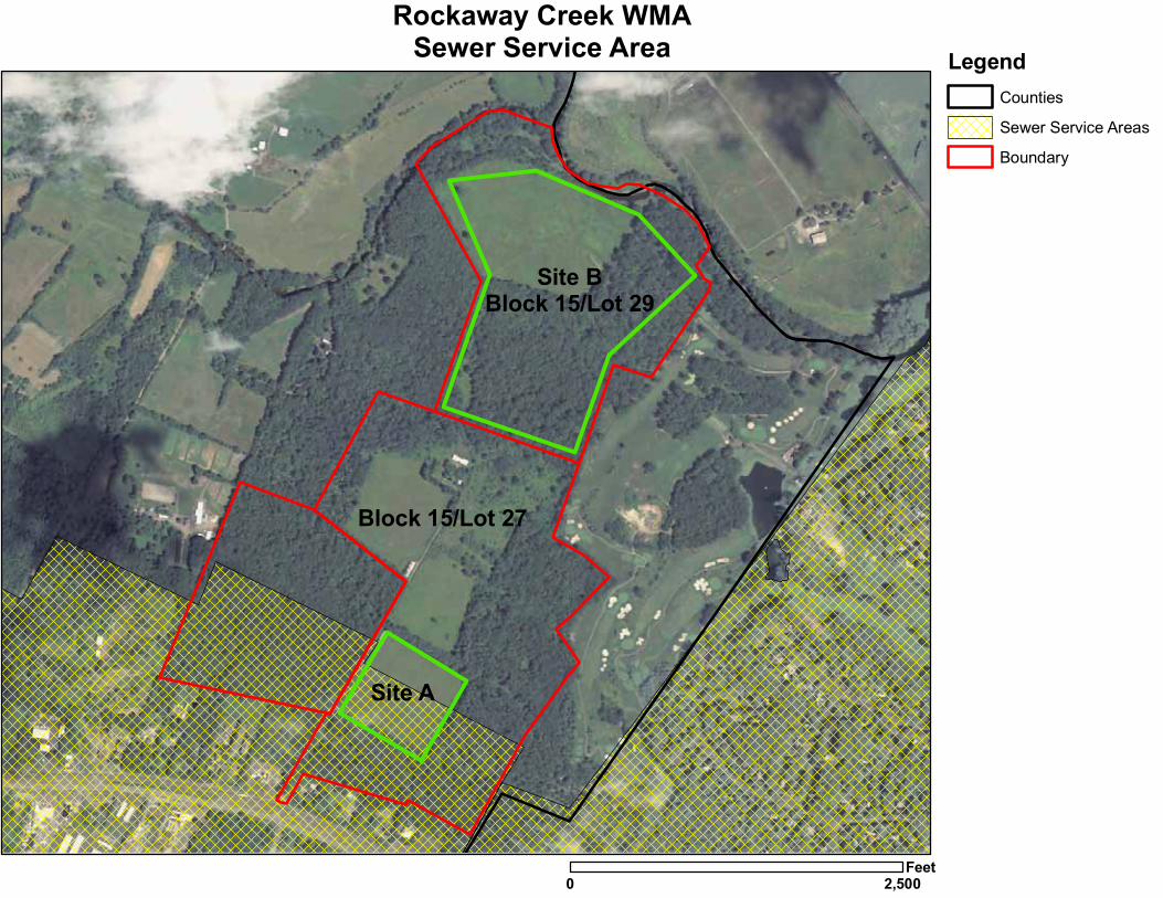
4.13 Sewer Service Area
Sewer service area (SSA) mapping shows the planned method of wastewater disposal for specific areas such as whether wastewater will be sent to a treatment facility or treated onsite and disposed of via groundwater or surface discharge. Land areas not specifically mapped as an SSA default to individual subsurface disposal systems discharging less than 2,000 gallons per day (gpd) as long as site conditions and existing regulations allow. The designation of an area being within an SSA is used to determine consistency with the Water Quality Management (WQM) Planning rules N.J.A.C. 7:15. Based on the SSA layer in GeoWeb a portion of the project area is located within an SSA (see Figure 5). The SSA boundary appears to coincide with the Townships Research-Office-Manufacturing (RO) zoning district.
5.0 Environmental Consequences: 5.1 No Action
The no action alternative would exclude any develop of a facility at the selected site. As described in section 3.0, the no-action alternative was deemed to be non-responsive to the needs of hunters and the general public and was dismissed from further consideration.
5.2 Black River WMA, Chester Township, Morris County
This site was considered to contain moderate to high sensitivity for prehistoric resources and a high sensitivity for historic archaeological resources. The proximity of wetlands and streams to the project area may limit the amount of useable land onsite. In addition if this site were selected, the proposed project would be considered a major Highlands development and would be subject to the regulations set forth in the Highlands Water Protection and Planning Act N.J.A.C. 7:38.
5.3 Berkshire Valley WMA, Roxbury Township, Morris County The portion of Berkshire Valley WMA selected for consideration as a potential project area consists of steep slopes, rock-outcrops, mature forest, suitable habitat for federally listed species and at least one known vernal pool. Although already owned by the State, this site would be costly to develop as it would involve clearing large areas of mature forest and significant grading to accomplish the goals of the Community Archery Park. In addition if this site were selected, the proposed project would be considered a major Highlands development and would be subject to the regulations set forth in the Highlands Water Protection and Planning Act N.J.A.C. 7:38.
5.4 Rockaway Creek WMA, Readington Township, Hunterdon County The Rockaway Creek WMA is ideally located with direct access to a major transportation corridor. The site includes an existing access drive, is adequate in acreage and is not encumbered by wetlands or suitable habitat for any federally listed threatened or endangered species. Topography in the fallow agricultural field is relatively level and it is anticipated that soil disturbance associated with grading activities would be minimal compared to the alternatives. In addition, this site is not encumbered by the rules set forth in the Highlands Water Protection and Planning Act N.J.A.C. 7:38 as it is located outside the Highlands Area entirely.
Site Plan Design Considerations
NJDEP Division of Fish and Wildlife, Community Archery Park Environmental Assessment
Environmental Assessment LAN Associates, EPAS, Inc. LAN Job #2.3397.124
Based upon the needs described in section 1, the goals stated in section 1.3, and the affected environment discussed in section 4, the Division of Fish and Wildlife has identified two potential locations for the indoor archery range/classroom building, Site A, and bow hunter education/recreational shooting 3-D field course, Site B. Site A will be located within Block 15 Lot 27 in a fallow field approximately 12 acres in size. A structure approximately 15,000-25,000 square feet in size, with a west facing orientation, will be developed at the site with associated parking for 200 cars, sanitary disposal and water supply facilities. The structure will include space for an indoor archery range, approximately 70 meters long, with ten shooting lanes, a multi-purpose/classroom, office space for Division and partner group personnel, storage space and lavatory facilities. The project will also develop three outdoor ranges, with an east facing orientation, directly behind the indoor range/classroom facility. The outdoor range component of the project will include a youth /community field ninety meters long by thirty meters wide, with ten shooting lanes, a practice field ninety meters long by sixty six meters wide, with twenty two shooting lanes, and an event field ninety meters long by eighty meters wide, with twenty shooting lanes. All shooting fields will have a pervious grass surface. A safety zone of ten meters, extending out to twenty meters, will be created between the three outdoor ranges. Site B will be developed within Block 15 Lot 29 an area comprised of fifty eight wooded acres and twenty two fallow field acres. The 3-D bow hunter education/competitive archery field course will consist of fourteen stations ranging from thirty to eighty yards in length. The field course layout will follow a design template created by Easton Foundations that considers the archer’s view of the target. The site design will provide thirty five meters of clear space behind the target and twenty meters of clear space at each side of the target at a maximum distance of seventy two meters. Terrain and natural features will be used to enhance safety zones as well as provide target situations that could be encountered in the field. Trail construction will attempt to minimize flooding and erosion. The existing access drive will need to be rehabilitated. In its current condition the drive consists of many ruts and depressions which will require leveling and possibly the installation of gravel and pavement.
5.5 Environmental Impacts
Land Use The proposed project area will not be located near any existing residences or schools and will not compromise any existing anthropogenic use of the land. The proposed facility would be consistent with the existing use of the land as a wildlife management area open to licensed hunting and fishing. Approximately fourteen (14) percent or thirty two (32) +/- acres of the existing parcel will be utilized as part of the proposed project. Vegetation Vegetation removal associated with the 3D target course in the forested area will be minimal and will likely consist of removing existing dead wood to protect the users of the course. As described in section 4.6, vegetation in the fallow agricultural field consists primarily of successional herbaceous growth. Disturbance of this vegetation will be the minimum necessary to construct the facility and related utilities. It is also anticipated that some of the development will occur within the footprint of the existing 3,600 +/- s.f. paddock structure therefore further minimizing the disturbance of vegetation.
NJDEP Division of Fish and Wildlife, Community Archery Park Environmental Assessment
Environmental Assessment LAN Associates, EPAS, Inc. LAN Job #2.3397.124
Threatened, Endangered and Rare Species According to GeoWeb the project area is not deemed suitable habitat for any threatened, endangered or rare species. Furthermore the most recent Species Occurrence Area (SOA) file did not indicate an occurrence of any federally listed species at the site. The SOA file did reveal that the site intersects with one (1) Upland Sandpiper (NJ State Endangered) breeding sighting, four (4) Great Blue Heron (NJ Special Concern) foraging and one (1) Eastern Box Turtle (NJ Special Concern) occupied habitat. It is anticipated that the project can be completed without adversely affecting any of these species or their habitat.
Historic and Cultural Resources
As discussed in section 4.9, LAN commissioned Richard Grubb & Associates, Inc. to perform an archaeological screening of the project area. See Appendix 2 for a complete copy of their letter report dated December 23, 2011. The conclusion of this report indicates that no known archaeological constraints were identified during background research. The project area was assessed as having a moderate sensitivity for prehistoric resources and a low to moderate sensitivity for historic resources. The conclusion of this report further states that, additional work could be necessary to fulfill the requirements of Section 106 of the National Historic Preservation Act, as amended, and state and municipal regulations (Paul J. McEachen, MA, RPA, Richard Grubb & Associates, Inc., Archaeological Screening Report, December 23, 2011). Given the majority of disturbance will be located within a previously disturbed agricultural field LAN anticipates that the proposed project can be accomplished with adversely affecting historic or cultural resources. However, as mentioned above additional investigations may be necessary to satisfy current regulations. Wetlands and Vernal Pools As mentioned in section 4.7, wetlands are present within the wooded area as shown on the GeoWeb wetlands layer. Disturbance to these wetlands or their transition areas is not expected. However, the official limits and resource classification of freshwater wetlands is established through a Letter of Interpretation or General Permit application to the NJDEP. Although disturbance is not anticipated it is likely that the extent of wetland areas near the project area will need to be verified by the NJDEP prior to any site improvements. As per GeoWeb, a vernal pool is present approximately 1,500 feet northwest of the project area. No disturbance to vernal pools is anticipated. Streams and Floodplains No streams or floodplains will be disturbed as part of this project. Prime Farmlands/Croplands The proposed project will not impact any prime farm or crop lands. Highlands Preservation Area The project area is not located within the Highlands Preservation or Planning Area. Soils
NJDEP Division of Fish and Wildlife, Community Archery Park Environmental Assessment
Environmental Assessment LAN Associates, EPAS, Inc. LAN Job #2.3397.124
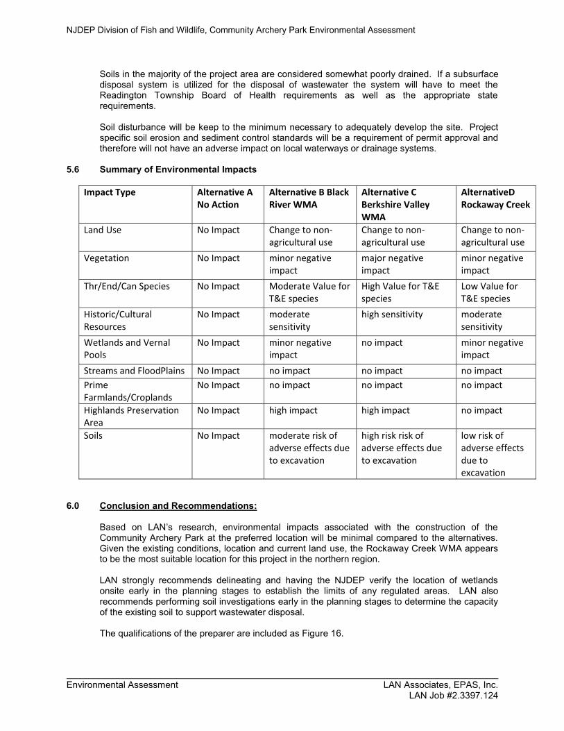
Soils in the majority of the project area are considered somewhat poorly drained. If a subsurface disposal system is utilized for the disposal of wastewater the system will have to meet the Readington Township Board of Health requirements as well as the appropriate state requirements. Soil disturbance will be keep to the minimum necessary to adequately develop the site. Project specific soil erosion and sediment control standards will be a requirement of permit approval and therefore will not have an adverse impact on local waterways or drainage systems.
5.6 Summary of Environmental Impacts Impact Type Alternative A
No Action Alternative B Black River WMA
Alternative C Berkshire Valley WMA
AlternativeD Rockaway Creek
Land Use No Impact Change to non-agricultural use
Change to non-agricultural use
Change to non-agricultural use
Vegetation No Impact minor negative impact
major negative impact
minor negative impact
Thr/End/Can Species No Impact Moderate Value for T&E species
High Value for T&E species
Low Value for T&E species
Historic/Cultural Resources
No Impact moderate sensitivity
high sensitivity moderate sensitivity
Wetlands and Vernal Pools
No Impact minor negative impact
no impact minor negative impact
Streams and FloodPlains No Impact no impact no impact no impact Prime Farmlands/Croplands
No Impact no impact no impact no impact
Highlands Preservation Area
No Impact high impact high impact no impact
Soils No Impact moderate risk of adverse effects due to excavation
high risk risk of adverse effects due to excavation
low risk of adverse effects due to excavation
6.0 Conclusion and Recommendations:
Based on LAN’s research, environmental impacts associated with the construction of the Community Archery Park at the preferred location will be minimal compared to the alternatives. Given the existing conditions, location and current land use, the Rockaway Creek WMA appears to be the most suitable location for this project in the northern region. LAN strongly recommends delineating and having the NJDEP verify the location of wetlands onsite early in the planning stages to establish the limits of any regulated areas. LAN also recommends performing soil investigations early in the planning stages to determine the capacity of the existing soil to support wastewater disposal. The qualifications of the preparer are included as Figure 16.

A RA R
A RA R
S R RS R R
R RR R
V RV R
R RR R
A RA R
A RA R
V RV R
A RA R
S R RS R R
S R RS R R
A RA R
A RA R
R OR O
A RA R
A RA R
A RA R
R RR R
S R RS R R
R OR O
V RV R
S R RS R R
BB
A RA R
A RA R
S R RS R R
S R RS R R
P N D 1P N D 1
V RV R
R O M 2R O M 2
BB
R RR R
V RV R
V CV C
P N DP N D
S C - 2S C - 2
H RH R
S R RS R R
R - 1R - 1
R OR O
P OP O
S R RS R R
V HV H
H RH R
P N DP N D
S R RS R RR O M 1R O M 1
BB
R - 1R - 1 P OP OR O M 1R O M 1
R O M 1R O M 1
P OP O
P N D / S C VP N D / S C V
R - 1R - 1
V CV C
P OP O
R OR O
BB
P OP O
V CV C
Readington Township, Hunterdon County, NJ July 2009
Zoning Map
Tewksbury TownshipHunterdon County
Bedminster TownshipSomerset County
Branchburg TownshipSomerset County
Clinton TownshipHunterdon County
Raritan TownshipHunterdon County
Hillsborough TownshipSomerset County
°Clarke Caton Hintz
ArchitecturePlanningLandscape Architecture
2,000 0 2,000 4,000 6,0001,000
Feet
!"#$78
!"#$78
Æÿ523
Æÿ620
(/22
(/22
(/202
(/202
Æÿ523
LegendZoneSRR - Special Resource Residential
AR - Agricultural Residential
RR - Rural Residential
VR - Village Residential
HR-Hamlet Residential
R-1 - Residential
PND - Planned Neighborhood Development
PND1 - Planned Neighborhood Development
PND/ SCV - Planned Neighborhood Dev./ Senior Citizen Village
SC- Senior Citizen
SC-2 - Senior Citizen 2
B - Business
VH - Village Hospitality
ROM1 - Research Office - Manufacturing
ROM2 - Research Office - Manufacturing
VC - Village Commercial
RO - Research - Office
PO-1 - Professional Office 1
PO - Professional Office
Airsafety and Historic Airport District
Historic Airport Sub-Area
Adopted July 6, 2009
Sources:Zoning: Readington Township; digitized by Clarke Caton Hintz
Parcels: Hatch Mott McDonald
Air Safety and Historic Airport District boundaries: digitized by Clarke Caton Hintz from Studer and McEldowney AutoCAD drawing"Map for Chambers Brook & Holland Brook Greenway"March 3, 2005 Drawing No 5761_F signed by H. Clay McEldowney
Site A
Site BBlock 15/Lot 29
Block 15/Lot 27
Rockaway Creek WMASewer Service Area
0 2,500Feet
LegendCounties
Sewer Service Areas
Boundary
Site A
Site BBlock 15/Lot 29
Block 15/Lot 2708876
08876
07921
08889Is
land
US Hwy 22 Kiva
Round Hill
Libb
y
Carol Jean
KatydidDriveway
Rattlesnake Bridge
Fox Chase
France
Wylden
Driv
eway
US Hwy 22
Rockaway Creek WMAWetlands
0 2,500Feet
LegendBoundary
WETLANDS
Counties
Roads (Tele Atlas)
Site A
Site BBlock 15/Lot 29
Block 15/Lot 2708876
08876
07921
08889Is
land
US Hwy 22 KivaRound Hill
Libb
y
Carol Jean
KatydidDriveway
Rattlesnake Bridge
France
Fox Chase
Wylden
Driv
eway
Driv
eway
US Hwy 22
Rockaway Creek WMAWetlands
0 2,600Feet
LegendVernal HabitatVPH_TYPE
Potential Vernal Habitat Area
Vernal Habitat Area
Boundary
Counties
Roads (Tele Atlas)
Vernal Habitat
Site A
Site BBlock 15/Lot 29
Block 15/Lot 2708876
08876
07921
08889Is
land
US Hwy 22
KivaRound Hill
Libb
y
Carol Jean
KatydidDriveway
Rattlesnake Bridge
France
Fox Chase
Wylden
Driv
eway
Driv
eway
US Hwy 22
Rockaway Creek WMA
0 2,500Feet
LegendLandscape Project 3.0 - StreamsRANK
Meets Habitat Suitability
Special Concern /S3
State Threatened
State Endangered
Federally Listed
Boundary
Counties
Roads (Tele Atlas)

Site A
Site BBlock 15/Lot 29
Block 15/Lot 27
08876
08876
07921
08889
Island
US Hwy 22
Lamington
Round Hill
Carol JeanHowell
KatydidFr
ance
Kiva
Lukes Pond
Rattlesnake Bridge
Fox Chase
Burnt
Mills
Libb
y
Tannery Coun
ty L
ine
Old Turnpike
Driveway
Campus
Parking LotW
ylden
US Hwy 22
Driveway
Driv
eway
Rockaway Creek WMANational Heritage Grid Map
0 3,000Feet
LegendBOTH - Both 'M' and 'S' Occurances
M- Documented Location Known Within 1.5 Miles
S - Documented Location Known Precisely
Boundary
MORRIS
SOMERSETHUNTERDON
WARREN
MIDDLESEXMERCER
MIDDLESEX
§̈¦78
§̈¦287
§̈¦287
§̈¦78
§̈¦287
§̈¦78
§̈¦287
rs31
rs27
rs28
rs57
rs12
rs179
rs173
rs182
rs173
rs31
£¤22£¤202
£¤206
£¤46
£¤1
£¤130
£¤206
£¤202
Rockaway Creek
OCEAN
SUSSEX
BURLINGTON
ATLANTIC
MORRIS
SALEM
MONMOUTH
WARREN
CUMBERLAND
HUNTERDON
BERGEN
MIDDLESEX
SOMERSET
CAPE MAY
MERCER
CAMDEN
PASSAIC
ESSEX
UNION
GLOUCESTER
HUDSON
#*
Proximity to Schools
SINCE 1965ENGINEERNG � PLANNING � ARCHITECTURE � SUR
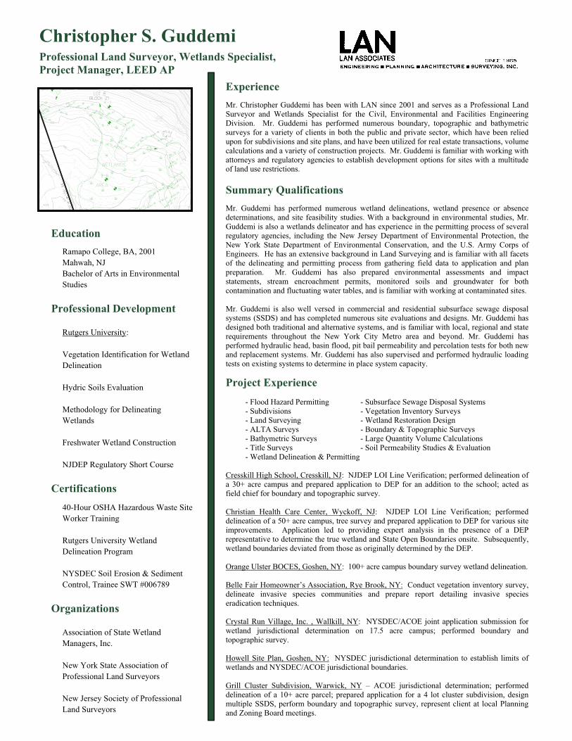
Christopher S. GuddemiProfessional Land Surveyor, Wetlands Specialist, Project Manager, LEED AP
EducationRamapo College, BA, 2001 Mahwah, NJ Bachelor of Arts in Environmental Studies
Professional Development
Rutgers University:
Vegetation Identification for Wetland Delineation
Hydric Soils Evaluation
Methodology for Delineating Wetlands
Freshwater Wetland Construction
NJDEP Regulatory Short Course
Certifications 40-Hour OSHA Hazardous Waste Site Worker Training
Rutgers University Wetland Delineation Program
NYSDEC Soil Erosion & Sediment Control, Trainee SWT #006789
Organizations
Association of State Wetland Managers, Inc.
New York State Association of Professional Land Surveyors
New Jersey Society of Professional Land Surveyors
ExperienceMr. Christopher Guddemi has been with LAN since 2001 and serves as a Professional Land Surveyor and Wetlands Specialist for the Civil, Environmental and Facilities Engineering Division. Mr. Guddemi has performed numerous boundary, topographic and bathymetric surveys for a variety of clients in both the public and private sector, which have been relied upon for subdivisions and site plans, and have been utilized for real estate transactions, volume calculations and a variety of construction projects. Mr. Guddemi is familiar with working with attorneys and regulatory agencies to establish development options for sites with a multitude of land use restrictions.
Summary Qualifications Mr. Guddemi has performed numerous wetland delineations, wetland presence or absence determinations, and site feasibility studies. With a background in environmental studies, Mr. Guddemi is also a wetlands delineator and has experience in the permitting process of several regulatory agencies, including the New Jersey Department of Environmental Protection, the New York State Department of Environmental Conservation, and the U.S. Army Corps of Engineers. He has an extensive background in Land Surveying and is familiar with all facets of the delineating and permitting process from gathering field data to application and plan preparation. Mr. Guddemi has also prepared environmental assessments and impact statements, stream encroachment permits, monitored soils and groundwater for both contamination and fluctuating water tables, and is familiar with working at contaminated sites.
Mr. Guddemi is also well versed in commercial and residential subsurface sewage disposal systems (SSDS) and has completed numerous site evaluations and designs. Mr. Guddemi has designed both traditional and alternative systems, and is familiar with local, regional and state requirements throughout the New York City Metro area and beyond. Mr. Guddemi has performed hydraulic head, basin flood, pit bail permeability and percolation tests for both new and replacement systems. Mr. Guddemi has also supervised and performed hydraulic loading tests on existing systems to determine in place system capacity.
Project Experience - Flood Hazard Permitting - Subsurface Sewage Disposal Systems - Subdivisions - Vegetation Inventory Surveys - Land Surveying - Wetland Restoration Design - ALTA Surveys - Boundary & Topographic Surveys - Bathymetric Surveys - Large Quantity Volume Calculations - Title Surveys - Soil Permeability Studies & Evaluation - Wetland Delineation & Permitting
Cresskill High School, Cresskill, NJ: NJDEP LOI Line Verification; performed delineation of a 30+ acre campus and prepared application to DEP for an addition to the school; acted as field chief for boundary and topographic survey.
Christian Health Care Center, Wyckoff, NJ: NJDEP LOI Line Verification; performed delineation of a 50+ acre campus, tree survey and prepared application to DEP for various site improvements. Application led to providing expert analysis in the presence of a DEP representative to determine the true wetland and State Open Boundaries onsite. Subsequently, wetland boundaries deviated from those as originally determined by the DEP.
Orange Ulster BOCES, Goshen, NY: 100+ acre campus boundary survey wetland delineation.
Belle Fair Homeowner’s Association, Rye Brook, NY: Conduct vegetation inventory survey, delineate invasive species communities and prepare report detailing invasive species eradication techniques.
Crystal Run Village, Inc. , Wallkill, NY: NYSDEC/ACOE joint application submission for wetland jurisdictional determination on 17.5 acre campus; performed boundary and topographic survey.
Howell Site Plan, Goshen, NY: NYSDEC jurisdictional determination to establish limits of wetlands and NYSDEC/ACOE jurisdictional boundaries.
Grill Cluster Subdivision, Warwick, NY – ACOE jurisdictional determination; performed delineation of a 10+ acre parcel; prepared application for a 4 lot cluster subdivision, design multiple SSDS, perform boundary and topographic survey, represent client at local Planning and Zoning Board meetings.
LAN No.: 2.3397.124
Photos by: CSG on
NJDEP/Rockaway Creek WMA in Readington/Proposed Archery Range/WO185-05
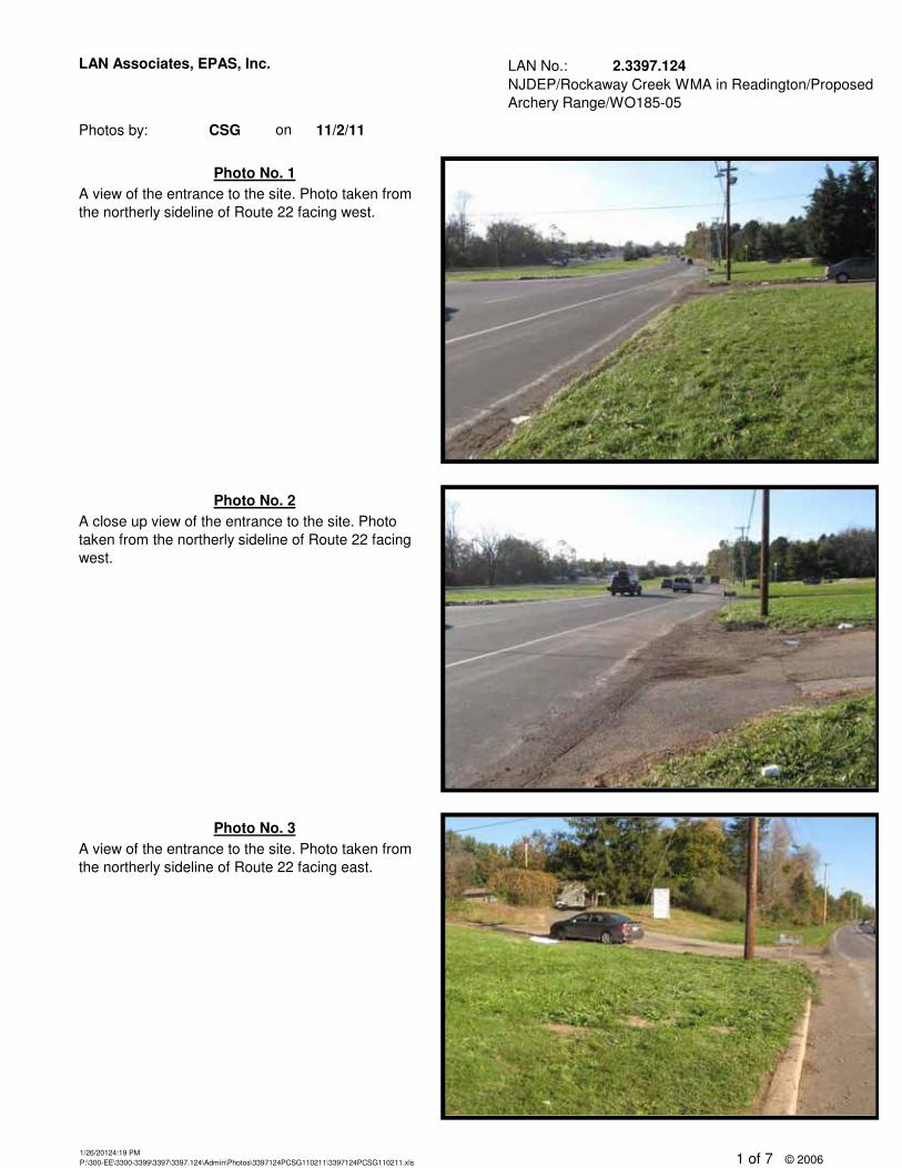
A close up view of the entrance to the site. Photo taken from the northerly sideline of Route 22 facing west.
Photo No. 2
11/2/11
LAN Associates, EPAS, Inc.
A view of the entrance to the site. Photo taken from the northerly sideline of Route 22 facing west.
Photo No. 1
Photo No. 3A view of the entrance to the site. Photo taken from the northerly sideline of Route 22 facing east.
1/26/20124:19 PMP:\300-EE\3300-3399\3397\3397.124\Admin\Photos\3397124PCSG110211\3397124PCSG110211.xls 1 of 7 © 2006
LAN No.: 2.3397.124
Photos by: CSG on
NJDEP/Rockaway Creek WMA in Readington/Proposed Archery Range/WO185-05
11/2/11
LAN Associates, EPAS, Inc.
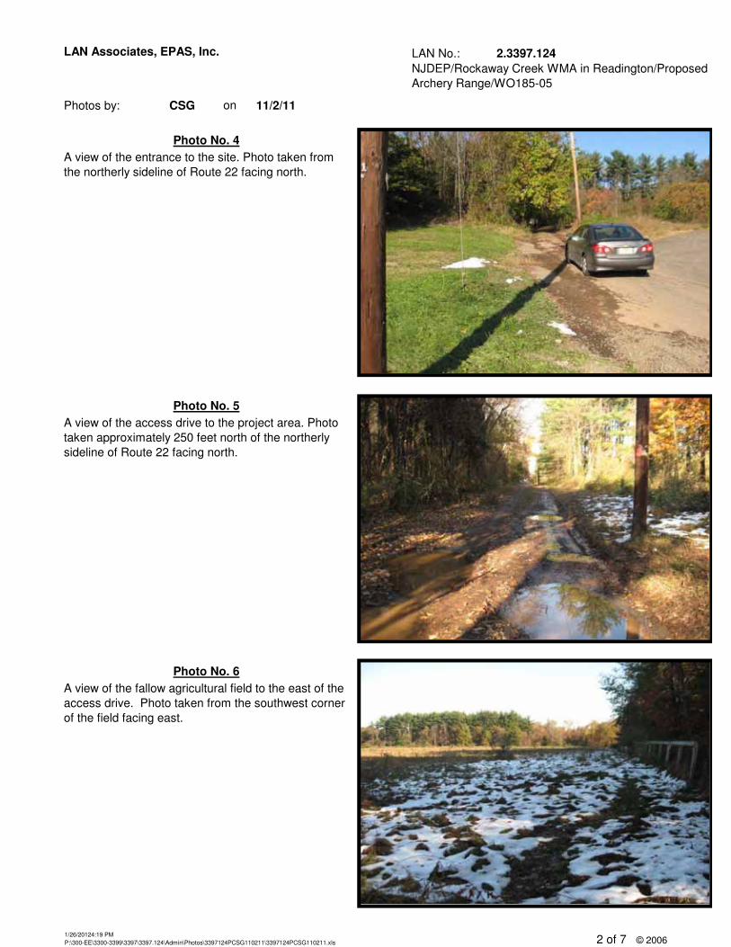
Photo No. 6A view of the fallow agricultural field to the east of the access drive. Photo taken from the southwest corner of the field facing east.
Photo No. 4
A view of the access drive to the project area. Photo taken approximately 250 feet north of the northerly sideline of Route 22 facing north.
Photo No. 5
A view of the entrance to the site. Photo taken from the northerly sideline of Route 22 facing north.
1/26/20124:19 PMP:\300-EE\3300-3399\3397\3397.124\Admin\Photos\3397124PCSG110211\3397124PCSG110211.xls 2 of 7 © 2006
LAN No.: 2.3397.124
Photos by: CSG on
NJDEP/Rockaway Creek WMA in Readington/Proposed Archery Range/WO185-05
11/2/11
LAN Associates, EPAS, Inc.
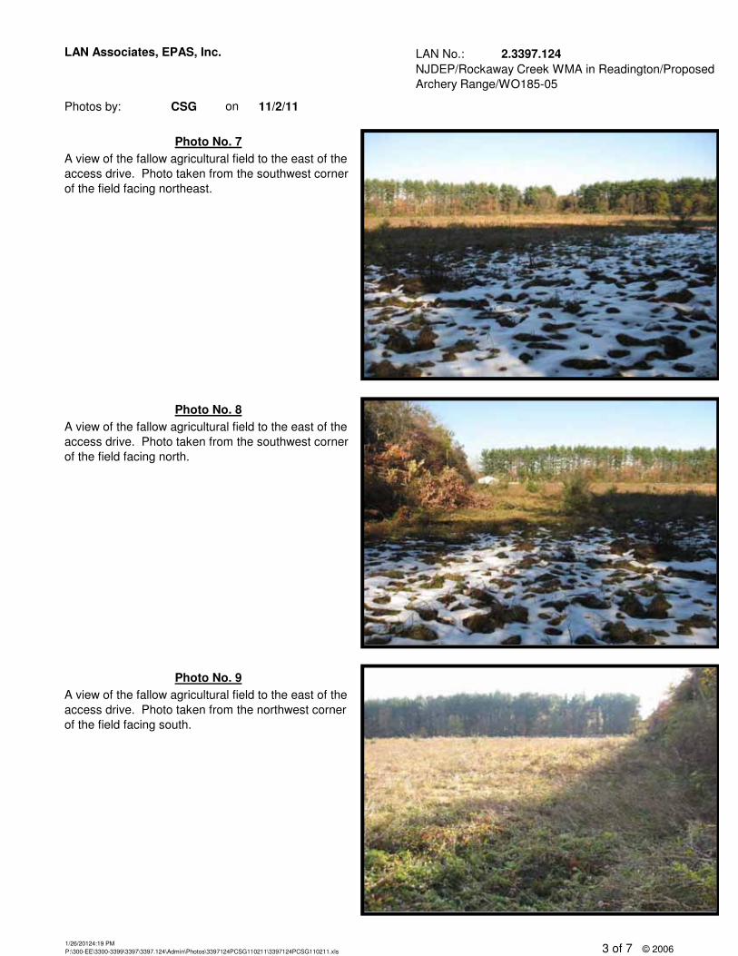
Photo No. 9
A view of the fallow agricultural field to the east of the access drive. Photo taken from the southwest corner of the field facing north.
A view of the fallow agricultural field to the east of the access drive. Photo taken from the northwest corner of the field facing south.
Photo No. 7A view of the fallow agricultural field to the east of the access drive. Photo taken from the southwest corner of the field facing northeast.
Photo No. 8
1/26/20124:19 PMP:\300-EE\3300-3399\3397\3397.124\Admin\Photos\3397124PCSG110211\3397124PCSG110211.xls 3 of 7 © 2006

LAN No.: 2.3397.124
Photos by: CSG on
NJDEP/Rockaway Creek WMA in Readington/Proposed Archery Range/WO185-05
11/2/11
LAN Associates, EPAS, Inc.
A view of the old paddock structure located at the northwest corner of the fallow agricultural field. Photo taken from the access drive facing north.
A view of the old paddock structure located at the northwest corner of the fallow agricultural field. Photo taken from the access drive facing northeast.
Photo No. 11
Photo No. 10
Photo No. 12
A view of the fallow agricultural field to the east of the access drive. Photo taken from the northwest corner of the field facing southeast.
1/26/20124:19 PMP:\300-EE\3300-3399\3397\3397.124\Admin\Photos\3397124PCSG110211\3397124PCSG110211.xls 4 of 7 © 2006
LAN No.: 2.3397.124
Photos by: CSG on
NJDEP/Rockaway Creek WMA in Readington/Proposed Archery Range/WO185-05
11/2/11
LAN Associates, EPAS, Inc.
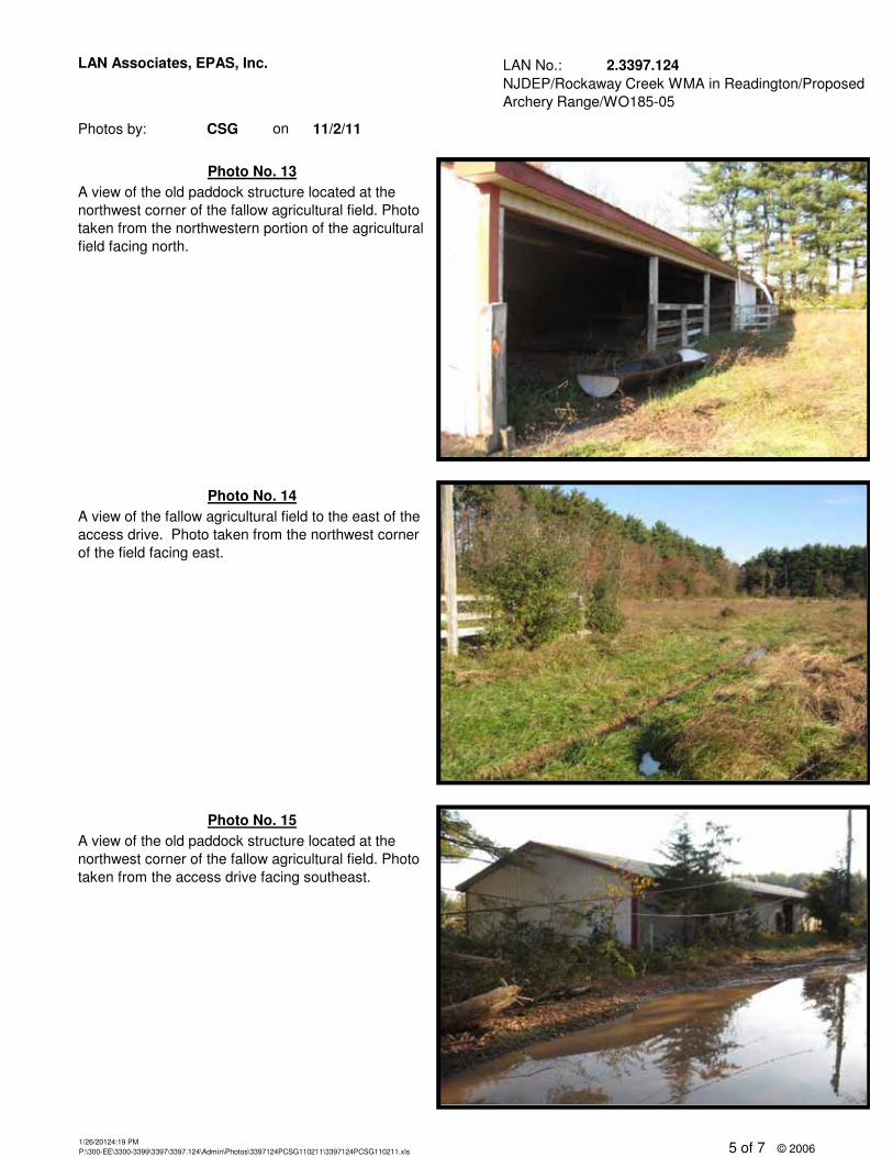
Photo No. 15A view of the old paddock structure located at the northwest corner of the fallow agricultural field. Photo taken from the access drive facing southeast.
A view of the old paddock structure located at the northwest corner of the fallow agricultural field. Photo taken from the northwestern portion of the agricultural field facing north.
A view of the fallow agricultural field to the east of the access drive. Photo taken from the northwest corner of the field facing east.
Photo No. 13
Photo No. 14
1/26/20124:19 PMP:\300-EE\3300-3399\3397\3397.124\Admin\Photos\3397124PCSG110211\3397124PCSG110211.xls 5 of 7 © 2006
LAN No.: 2.3397.124
Photos by: CSG on
NJDEP/Rockaway Creek WMA in Readington/Proposed Archery Range/WO185-05
11/2/11
LAN Associates, EPAS, Inc.
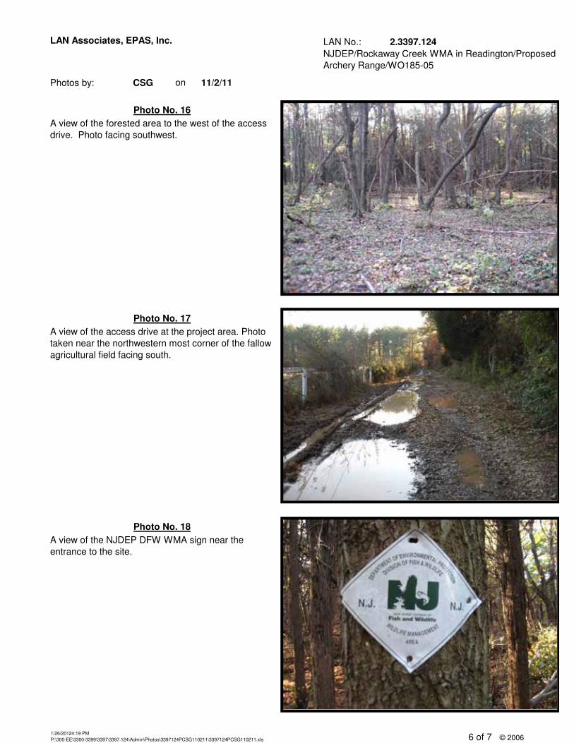
A view of the forested area to the west of the access drive. Photo facing southwest.
Photo No. 17
Photo No. 18
Photo No. 16
A view of the NJDEP DFW WMA sign near the entrance to the site.
A view of the access drive at the project area. Photo taken near the northwestern most corner of the fallow agricultural field facing south.
1/26/20124:19 PMP:\300-EE\3300-3399\3397\3397.124\Admin\Photos\3397124PCSG110211\3397124PCSG110211.xls 6 of 7 © 2006
LAN No.: 2.3397.124
Photos by: CSG on
NJDEP/Rockaway Creek WMA in Readington/Proposed Archery Range/WO185-05
11/2/11
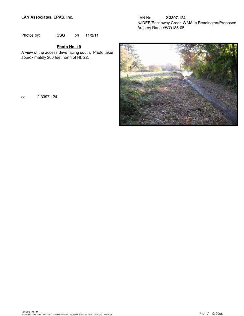
LAN Associates, EPAS, Inc.
cc: 2.3397.124
Photo No. 19A view of the access drive facing south. Photo taken approximately 200 feet north of Rt. 22.
1/26/20124:19 PMP:\300-EE\3300-3399\3397\3397.124\Admin\Photos\3397124PCSG110211\3397124PCSG110211.xls 7 of 7 © 2006
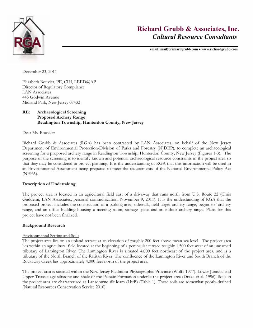
Richard Grubb & Associates, Inc. Cultural Resource Consultants
email: [email protected] � www.richardgrubb.com
December 23, 2011 Elizabeth Bouvier, PE, CIH, LEED@AP Director of Regulatory Compliance LAN Associates 445 Godwin Avenue Midland Park, New Jersey 07432 RE: Archaeological Screening
Proposed Archery Range Readington Township, Hunterdon County, New Jersey Dear Ms. Bouvier: Richard Grubb & Associates (RGA) has been contracted by LAN Associates, on behalf of the New Jersey Department of Environmental Protection-Division of Parks and Forestry (NJDEP), to complete an archaeological screening for a proposed archery range in Readington Township, Hunterdon County, New Jersey (Figures 1-3). The purpose of the screening is to identify known and potential archaeological resource constraints in the project area so that they may be considered in project planning. It is the understanding of RGA that this information will be used in an Environmental Assessment being prepared to meet the requirements of the National Environmental Policy Act (NEPA). Description of Undertaking The project area is located in an agricultural field east of a driveway that runs north from U.S. Route 22 (Chris Guddemi, LAN Associates, personal communication, November 9, 2011). It is the understanding of RGA that the proposed project includes the construction of a parking area, sidewalk, field target archery range, beginners’ archery range, and an office building housing a meeting room, storage space and an indoor archery range. Plans for this project have not been finalized. Background Research Environmental Setting and Soils The project area lies on an upland terrace at an elevation of roughly 200 feet above mean sea level. The project area lies within an agricultural field located at the beginning of a peninsular terrace roughly 1,500 feet west of an unnamed tributary of Lamington River. The Lamington River is situated 4,000 feet northeast of the project area, and is a tributary of the North Branch of the Raritan River. The confluence of the Lamington River and South Branch of the Rockaway Creek lies approximately 4,000 feet north of the project area. The project area is situated within the New Jersey Piedmont Physiographic Province (Wolfe 1977). Lower Jurassic and Upper Triassic age siltstone and shale of the Passaic Formation underlie the project area (Drake et al. 1996). Soils in the project area are characterized as Lansdowne silt loam (LbtB) (Table 1). These soils are somewhat poorly-drained(Natural Resources Conservation Service 2010).
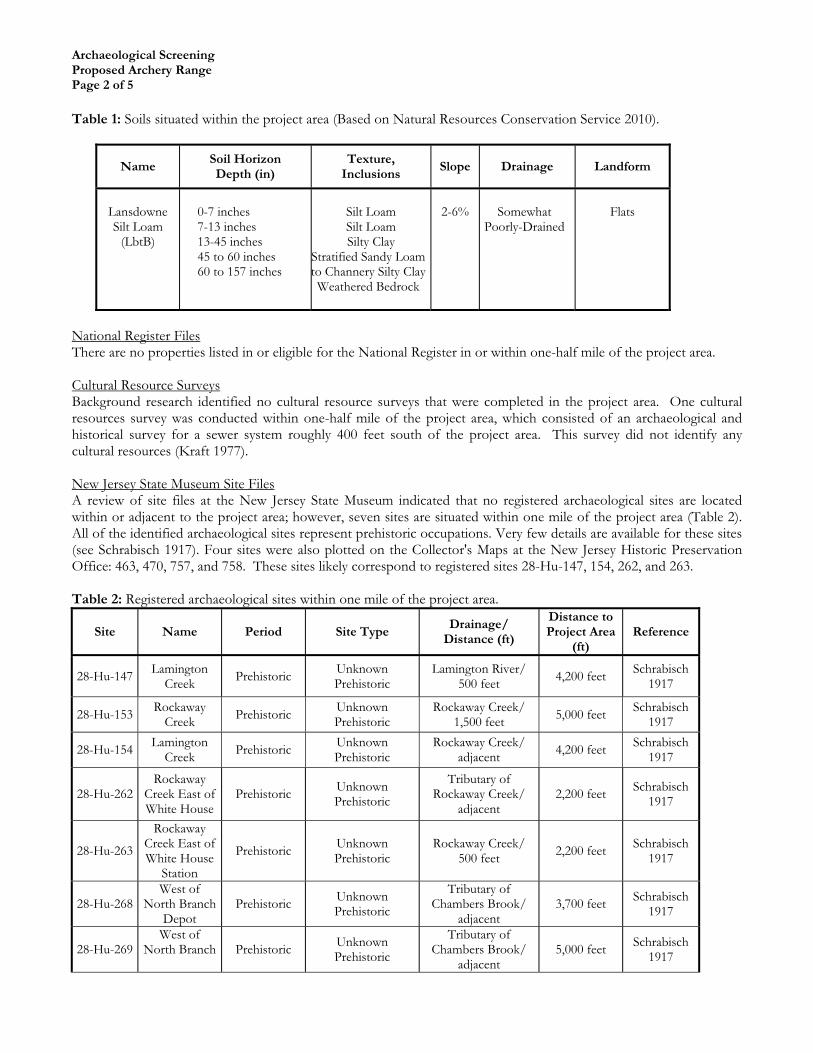
Archaeological Screening Proposed Archery Range Page 2 of 5
Table 1: Soils situated within the project area (Based on Natural Resources Conservation Service 2010).
Name Soil Horizon Depth (in)
Texture, Inclusions
Slope Drainage Landform
Lansdowne Silt Loam
(LbtB)
0-7 inches 7-13 inches 13-45 inches 45 to 60 inches 60 to 157 inches
Silt Loam Silt Loam Silty Clay
Stratified Sandy Loam to Channery Silty ClayWeathered Bedrock
2-6% Somewhat Poorly-Drained
Flats
National Register Files There are no properties listed in or eligible for the National Register in or within one-half mile of the project area. Cultural Resource Surveys Background research identified no cultural resource surveys that were completed in the project area. One cultural resources survey was conducted within one-half mile of the project area, which consisted of an archaeological and historical survey for a sewer system roughly 400 feet south of the project area. This survey did not identify any cultural resources (Kraft 1977). New Jersey State Museum Site Files A review of site files at the New Jersey State Museum indicated that no registered archaeological sites are located within or adjacent to the project area; however, seven sites are situated within one mile of the project area (Table 2). All of the identified archaeological sites represent prehistoric occupations. Very few details are available for these sites (see Schrabisch 1917). Four sites were also plotted on the Collector's Maps at the New Jersey Historic Preservation Office: 463, 470, 757, and 758. These sites likely correspond to registered sites 28-Hu-147, 154, 262, and 263. Table 2: Registered archaeological sites within one mile of the project area.
Site Name Period Site Type Drainage/
Distance (ft)
Distance to Project Area
(ft) Reference
28-Hu-147 Lamington Creek Prehistoric Unknown
Prehistoric Lamington River/
500 feet 4,200 feet Schrabisch 1917
28-Hu-153 Rockaway Creek Prehistoric Unknown
Prehistoric Rockaway Creek/
1,500 feet 5,000 feet Schrabisch 1917
28-Hu-154 Lamington Creek Prehistoric Unknown
Prehistoric Rockaway Creek/
adjacent 4,200 feet Schrabisch 1917
28-Hu-262 Rockaway
Creek East of White House
Prehistoric Unknown Prehistoric
Tributary of Rockaway Creek/
adjacent 2,200 feet Schrabisch
1917
28-Hu-263
Rockaway Creek East of White House
Station
Prehistoric Unknown Prehistoric
Rockaway Creek/ 500 feet 2,200 feet Schrabisch
1917
28-Hu-268 West of
North Branch Depot
Prehistoric Unknown Prehistoric
Tributary of Chambers Brook/
adjacent 3,700 feet Schrabisch
1917
28-Hu-269 West of
North Branch Prehistoric Unknown Prehistoric
Tributary of Chambers Brook/
adjacent5,000 feet Schrabisch
1917
Archaeological Screening Proposed Archery Range Page 3 of 5
Historic Maps and Aerials A review of historic atlases and maps suggests that project area and vicinity was moderately developed during the late eighteenth through nineteenth century (Hills 1781; Cornell 1851; Beers 1873). The project area was situated northwest of an area known as Mechanicsville during the mid-nineteenth century. A farm lane was surveyed on the west side of the project area on mid-nineteenth-century maps, which led from the Somerville and Easton Turnpike (future U.S. Route 22) to a farmstead owned by W. Ditmus in 1851 and J. B. Ditmars in 1873 (Cornell 1851, Beers 1873). The farmstead was situated approximately 1,300 feet north of the project area. Further, several dwellings and a blacksmith shop located 600 feet south of the project area lined the north side of Somerville and Easton Turnpike during the mid-nineteenth century (Cornell 1851; Beers 1873). Most of the dwellings and the blacksmith shop were razed prior to 1931 (NETR 1931). The project area was characterized as an open agricultural field from the early twentieth to early twenty-first century (NETR 1931, 1940, 1953, 1956, 1963, 1970, 1971, 1972, 1979, 1987, 1988, 1995, 2002, 2006, 2007). Between 1979 and 1987, a large storage structure was erected near the project area in the northwest corner of the agricultural field (NETR 1979, 1987). Site Visit The project area was examined on November 11, 2011 by Allison Gall, Project Archaeologist. The project area is located on the east side of a 2,700-foot long nineteenth-century driveway that extends from U.S. Route 22 to the former Ditmus farm complex. The project area is situated in a large, fallow, agricultural field. One large storage structure or paddock, constructed in the late twentieth century, is situated in the northwestern portion of the agricultural field. With the exception of agricultural plowing, no extensive disturbance was visible within the project area. No foundations or artifacts were observed during the site visit. Sensitivity Assessment Prehistoric Resources The topographic setting and background research suggest that the project area has a moderate sensitivity to contain prehistoric resources. Historic Resources Based on an examination of historic atlases, maps, and aerials, the project area is situated along a nineteenth century driveway, with nineteenth-century structures formerly located roughly 1,500 feet north and approximately 600 feet south of the project area. Given the distance to these structures, the sensitivity for related historic archaeological resources within the project area is considered low to moderate. Conclusions No known archaeological constraints were identified during background research. The project area was assessed as having a moderate sensitivity for prehistoric resources and a low to moderate sensitivity for historic resources. However, additional work could be necessary to fulfill the requirements of Section 106 of the National Historic Preservation Act, as amended, and state and municipal regulations.
Please call me at 609-655-0692, ext. 309 if you have any questions.
Sincerely,
Paul J. McEachen, MA, RPA Principal Senior Archaeologist PJM:mjg
Archaeological Screening Proposed Archery Range Page 4 of 5
References: Beers, F.W. 1873 Atlas of Hunterdon County, New Jersey. Beers, Comstock, and Cline, New York, New York. Bohren and Bohren Associates, Inc. 2003 Survey of Land for Readington Township, Block 15, Lots 5, 27, & 29. On file, Bohren and Bohren
Associates, Inc. Flemington, New Jersey. Cornell, Samuel C. 1851 Map of Hunterdon County, New Jersey. Lloyd Vanderveer and S.C. Cornell, Camden, New Jersey.
Drake, Jr., Avery, Richard Volkert, Donald Monteverde, Gregory Herman, Hugh Houghton, Ronald Parker, and Richard Dalton 1996 Bedrock Geologic Map of Northern New Jersey. U.S. Geological Survey, U.S. Department of the Interior,
Washington, D.C. Hagstrom Map Company, Inc. 2005 Street Map of Hunterdon County, New Jersey. Hagstrom Map Company, Inc., Maspeth, New York.
Hills, J. 1781 A Sketch of the Northern Parts of New Jersey, Reduced from the Original Survey.
Kraft, Herbert C. 1977 Archaeological and Historical Survey of the Proposed Collector Sewer System, Borough of Whitehouse,
Hunterdon County, New Jersey. On file, Historic Preservation Office, Trenton, New Jersey. Nationwide Environmental Title Research (NETR) 1931 Historic Aerials. Electronic document, http://www.historicaerials.com/, accessed November 7, 2011. 1940 Historic Aerials. Electronic document, http://www.historicaerials.com/, accessed November 7, 2011. 1953 Historic Aerials. Electronic document, http://www.historicaerials.com/, accessed November 7, 2011. 1956 Historic Aerials. Electronic document, http://www.historicaerials.com/, accessed November 7, 2011. 1963 Historic Aerials. Electronic document, http://www.historicaerials.com/, accessed November 7, 2011. 1970 Historic Aerials. Electronic document, http://www.historicaerials.com/, accessed November 7, 2011. 1971 Historic Aerials. Electronic document, http://www.historicaerials.com/, accessed November 7, 2011. 1972 Historic Aerials. Electronic document, http://www.historicaerials.com/, accessed November 7, 2011. 1979 Historic Aerials. Electronic document, http://www.historicaerials.com/, accessed November 7, 2011. 1987 Historic Aerials. Electronic document, http://www.historicaerials.com/, accessed November 7, 2011. 1988 Historic Aerials. Electronic document, http://www.historicaerials.com/, accessed November 7, 2011. 1995 Historic Aerials. Electronic document, http://www.historicaerials.com/, accessed November 7, 2011. 2002 Historic Aerials. Electronic document, http://www.historicaerials.com/, accessed November 7, 2011. 2006 Historic Aerials. Electronic document, http://www.historicaerials.com/, accessed November 7, 2011. 2007 Historic Aerials. Electronic document, http://www.historicaerials.com/, accessed November 7, 2011. Natural Resources Conservation Service 2010 Web Soil Survey. Electronic document, http://websoilsurvey.nrcs.usda.gov/app/WebSoilSurvey.aspx. Accessed November 2, 2011. Schrabisch, Max 1917 Archaeology of Warren and Hunterdon Counties. Bulletin 18, Geological Survey of New Jersey, Trenton, New Jersey.

Archaeological Screening Proposed Archery Range Page 5 of 5
United States Geological Survey 1955 7.5’ Quadrangle: Raritan, NJ (photorevised 1981) 1995 7.5’ Quadrangle: Gladstone, NJ Wolfe, Peter E. 1977 The Geology and Landscapes of New Jersey. Crane, Russak & Company, New York, New York.

FIGURES AND PHOTO PLATES
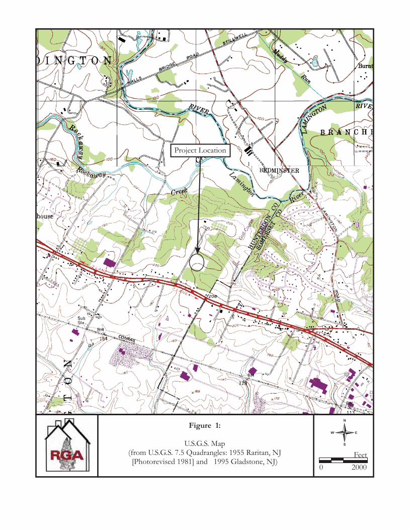
Figure 1:
U.S.G.S. Map(from U.S.G.S. 7.5 Quadrangles: 1955 Raritan, NJ[Photorevised 1981] and 1995 Gladstone, NJ)
0
Feet
2000
Project Location
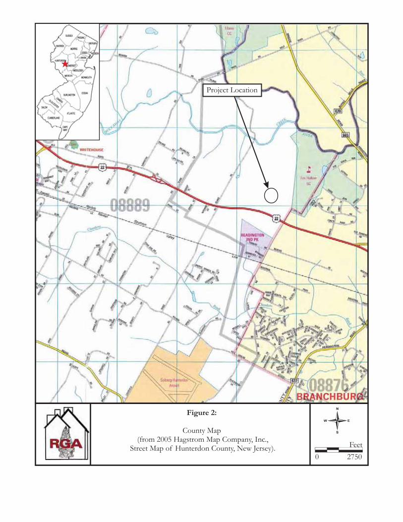
Figure 2:
County Map(from 2005 Hagstrom Map Company, Inc.,
Street Map of Hunterdon County, New Jersey).
Project Location
0
Feet
2750
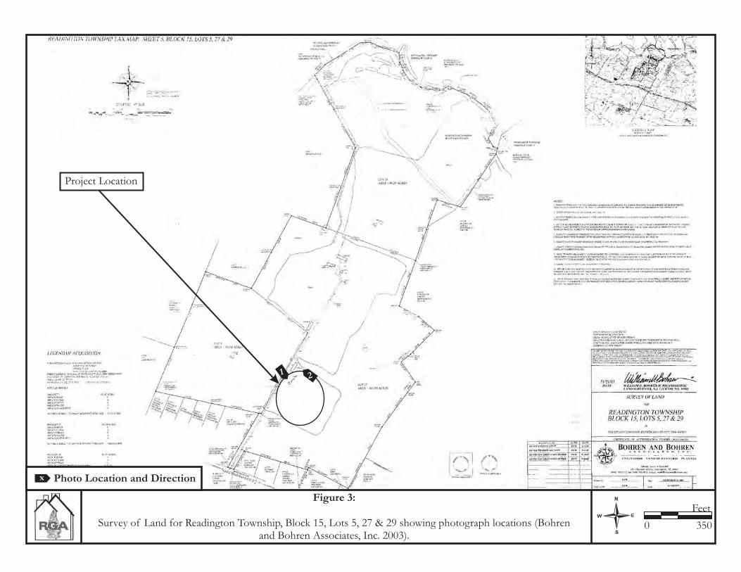
Figure 3:
Survey of Land for Readington Township, Block 15, Lots 5, 27 & 29 showing photograph locations (Bohrenand Bohren Associates, Inc. 2003).
0
Feet
350
Project Location
Photo Location and Directionx
1 2
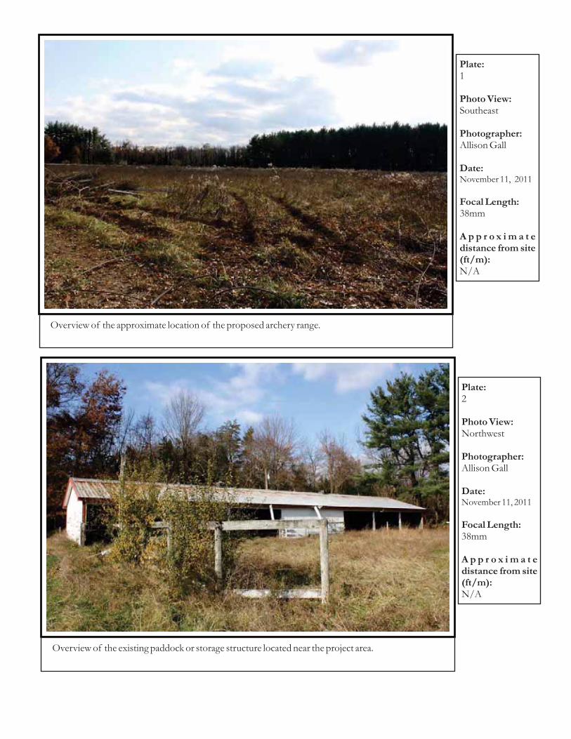
Plate:
Photo View:
Photographer:
Date:
Focal Length:
A p p r o x i m a t edistance from site(ft/m):
1
Southeast
Allison Gall
38mm
N/A
November 11, 2011
Overview of the approximate location of the proposed archery range.
Plate:
Photo View:
Photographer:
Date:
Focal Length:
A p p r o x i m a t edistance from site(ft/m):
2
Northwest
Allison Gall
38mm
N/A
November 11, 2011
Overview of the existing paddock or storage structure located near the project area.