Embed Size (px)
Citation preview

New Jersey Department of Environmental Protection
Bureau of Discharge Prevention
ENVIRONMENTALLY SENSITIVE AREASGUIDANCE DOCUMENT
This "Guidance on Environmentally Sensitive Areas" is intended for use as a reference and a guide when gatheringinformation to be used in preparing the topographical maps for Discharge Prevention, Containment andCountermeasure (DPCC), and Discharge Cleanup and Removal (DCR) Plans. It gathers in oneplace all the citations listed in N.J.A.C. 7:1E-1.8, which establishes the definition ofenvironmentally sensitive areas for the purpose of developing the DPCC/DCR plan. The areasdescribed in this document are by no means the only environmentally sensitive areas in NewJersey, but represent those most likely to be adversely affected by the discharge of a hazardoussubstance. When used in conjunction with N.J.A.C. 7:1, Appendix A, "Mapping and Digital DataStandards", it will prove useful in preparing the topographical maps and the environmentallysensitive areas protection plan that are required as part of the Discharge Cleanup and Removalplan.
Introduction
N.J.A.C. 7:1E-4.2(b)6 requires that topographical maps covering all surrounding areas whichcould be affected by a discharge from a facility, including environmentally sensitive areas, beincluded in the Discharge Prevention, Containment and Countermeasure (DPCC) plan. Inaddition, a deployment plan covering environmentally sensitive areas is to be submitted as a partof the Discharge Cleanup and Removal (DCR) plan, N.J.A.C. 7:1E-4.3(a)7. N.J.A.C. 7:1E-1.8sets forth geographical areas which will be considered environmentally sensitive areas for thepurposes of designing and implementing the DPCC and DCR plans.
The definition of "environmentally sensitive areas" at N.J.A.C. 7:1E-1.8 has been developed forplanning and use in the prevention and control of discharges of hazardous substances. The termis referred to in the Spill Compensation and Control Act (N.J.S.A. 58:10-23.11 et seq.), but is notdefined therein.
A task force drawn from the diverse programs within the Department used a number of factors inorder to define environmentally sensitive areas. These factors included importance to the qualityof life in New Jersey, scarcity of the resource, importance placed on the area by other State andfederal legislation, and the ecology of the area. The areas which the task force determined shouldbe given the highest priority in protection from discharges, based on the above factors, areincluded in the definition of "environmentally sensitive areas".
The resulting definition, at N.J.A.C. 7:1E-1.8, describes those areas which would be most likelyto be adversely affected by the discharge of a hazardous substance. The owner or operator of amajor facility is responsible for determining whether these areas would be affected by adischarge from their facility. Environmentally sensitive areas may need special protection in theevent of a discharge. By identifying and mapping such areas, owners or operators of majorfacilities will be better able to prioritize their responses to a discharge.
The following document describes each area which is considered environmentally sensitivepursuant to N.J.A.C. 7:1E-1.8, giving a brief summary of what this area encompasses and thepertinent text of the citation(s) referenced.
Table of Contents
Page
Surface waters 1
Sources of water supply 3
Bay islands and barrier island corridors 4
Beaches 5
Dunes 6
Wetlands and wetland transition areas 7
Breeding areas 9
Migratory stopover areas 10
Wintering areas 11
Prime fishing areas 12
Finfish migratory pathways 13
Water areas supporting submerged vegetation 14
Shellfish harvesting waters 15
Forest areas 16
Habitat for federal and State endangered or threatened
plant and animal species 17
Federal and State wilderness areas 29
Areas designated as wild, scenic, recreational, or developed
recreational rivers 40
SURFACE WATERS
AREA: N.J.A.C. 7:1E-1.8(a)1, Surface waters, including without limitation the following:large rivers, medium rivers, streams, creeks, ponds, lakes and reservoirs as defined in N.J.A.C.7:7E-4.1, canals as defined in N.J.A.C. 7:7E-3.8, estuaries, as defined in 33 U.S.C. 1330(k), andbays, including without limitation open bays, semi-enclosed bays and back bays, as defined inN.J.A.C. 7:7E-4.1.
ENVIRONMENTAL IMPORTANCE: Surface waters include all types of open water, suchas rivers, streams, ponds, lakes, bays, canals, and estuaries. These must be protected to preventwaterfowl, animals, and fish from being adversely affected by a discharge. In addition, watersimportant for recreational activities, such as boating and fishing, are included in this categoryand must be protected for their cultural and economic value. Freshwater waterways serving aspassages to and from spawning areas are important for the survival of numerous varieties of fishand are thus to be protected. Water areas are wintering points for birds, such as the CanadaGoose and other waterfowl, and breeding areas for colonial waterbirds and aquatic furbearers,such as otter, muskrat, beaver, and mink.
CITATIONS: N.J.A.C. 7:7E-4.1 defines large rivers as waterways with watersheds greater than1,000 square miles, which means the Delaware, Hudson, and Raritan Rivers.
1. The Delaware River is a tidal river from the Bridge Street Bridge in Trenton to its mouthat Delaware Bay, defined as a line between Alder Cover, Lower Alloways Creek Township andthe Delaware River Basin Commission-River and Bay Memorial at Liston Point, Delaware.
2. The Hudson River is a tidal river from the New York State Line to its mouth at UpperNew York Bay at the Morris Canal, Jersey City.
3. The Raritan River is a tidal river from a point approximately 1.1 miles upstream from theLanding Lane Bridge between Piscataway and Franklin Townships to its mouth at Raritan Bayand the Arthur Kill.
N.J.A.C. 7:7E-4.1 defines medium rivers, streams and creeks as channels with a watershed areaof less than 1,000 square miles. This includes watercourses such as the Hackensack, Passaic,Oldmans, Big Timber, Pennsauken, Navesink, Manasquan, Toms, Wading, Mullica, Great Egg,Maurice, Cohansey, Salem and Rancocas and smaller streams.
Ponds, lakes and reservoirs are defined by N.J.A.C. 7:7E-4.1 as relatively small water bodieswith no tidal influence or salinity. Many are groundwater fed, while others serve as surfaceaquifer recharge areas. Lakes that are the result of former mining operations are not includedhere, but are defined separately as wet borrow pits.
N.J.A.C. 7:7E-3.8 states that canals are navigation channels for boat traffic through land areaswhich are created by cutting and dredging or other human construction technique sometimes
enlarging existing natural surface water channels. The Cape May, Bay Head-Manasquan, andDelaware and Raritan Canals are the principal examples in the New Jersey Coastal zone.
In accordance with 33 U.S.C. 1330(k), the term "estuarine zone" means an environmental systemconsisting of an estuary and those transitional areas which are consistently influenced or affectedby water from the estuary such as, but not limited to, salt marshes, coastal and intertidal areas,bays, harbors, lagoons, inshore waters, and channels, and shall also include associated aquaticecosystems and those portions of tributaries draining into the estuary up to the historic height ofmigration of anadromous fish or the historic head of tidal influence, whichever is higher. Theterm "estuary" means all or part of the mouth of a river or stream or other body of water havingunimpaired natural connection with open sea and within which the sea water is measurablydiluted with fresh water derived from land drainage.
According to N.J.A.C. 7:7E-4.1, an "open bay" is defined as a large, semi-confined estuary witha wide unrestricted inlet to the ocean and with a major river mouth discharging directly into itsupper portion. Delaware Bay, Raritan Bay, Sandy Hook Bay, and Upper New York Bay are theonly representatives of this waterbody type in New Jersey.
Semi-enclosed bays and back bays are defined at N.J.A.C. 7:7E-4.1 as a partially confinedestuary with direct inlet connection and some inflow of freshwater. Semi-enclosed bays differfrom back bays in depth, degree of restriction of inlet and level of freshwater inflow. Great Bayand Great Egg Harbor are examples of semi-enclosed bays; Barnegat Bay, Little Egg Harbor, theShark River estuary and other bays in Atlantic and Cape May Counties are back bays.
SOURCES OF WATER SUPPLY
AREA: N.J.A.C. 7:1E-1.8(a)2, Sources of water supply, including surface water intakesand wells drawing from aquifers and confined aquifers as defined at N.J.A.C. 7:19-1.3, which areutilized by public community water systems, public noncommunity water systems, public watersystems, nonpublic water systems and water systems as defined in N.J.A.C. 7:10-1.3.
ENVIRONMENTAL IMPORTANCE: Sources of water supply include feeder streamsentering a water supply reservoir, reservoirs and buffer zones, surface water intakes, and theaquifers utilized by water supply wells with their attendant wellhead protection areas. Thesemust be protected to prevent contamination of drinking water supplies and widespread and longlasting contamination of aquifers.
CITATIONS: AAquifer@ is defined by N.J.A.C. 7:19-1.3 as any subsurface water-saturated zonewhich is significantly permeable so that it may yield sufficient quantities of water from wells orsprings in order to serve as a practical source of water, while a Aconfined aquifer@ is an aquiferwhich contains groundwater under pressure between or below relatively impermeable orsignificantly less permeable material so that the water surface rises above the top of the aquiferin a well which derives its water from that aquifer.
According to N.J.A.C. 7:10-1.3, "public water system" means a system for the provision to thepublic of piped water for human consumption, if such system has at least 15 service connectionsor regularly serves at least 25 individuals daily at least 60 days out of the year. Such termincludes: any collection, treatment, storage and distribution facilities under control of theoperator of such system and used primarily in connection with such system, and any collection orpretreatment storage facilities not under such control which are used primarily in connectionwith such system. A public water system is either a "community water system" or a "non-community water system".
"Public community water system" means a public water system which serves at least 15 serviceconnections used by year-round residents or regularly serves at least 25 year-round residents.
"Public noncommunity water system" means a public water system that is not a communitywater system.
"Water system" means a system for providing potable water to any person.
"Nonpublic system" means a water system that is not a public water system.
BAY ISLANDS AND BARRIER ISLAND CORRIDORS
AREA: N.J.A.C. 7:1E-1.8(a)3, Bay islands as defined at N.J.A.C. 7:7E-3.21, and barrierisland corridors as defined at N.J.A.C. 7:7E-3.20.
ENVIRONMENTAL IMPORTANCE: Bay islands are non-oceanfront islands surroundedby tidal waters. Barrier island corridors are those portions lying upland of wetlands and beachesincluding the filled water's edge. They provide valuable wildlife habitat and potential habitat forcolonial nesting birds and threatened and endangered species.

CITATIONS: N.J.A.C. 7:7E-3.21 states that bay islands are islands or filled areas surrounded bytidal waters, wetlands, beaches or dunes, lying between the mainland and barrier islands. Suchislands may be connected to the mailand or barrier island by elevated or fill supported roads.
Barrier island corridors are defined by N.J.A.C. 7:7E-3.20 as being the interior portions ofoceanfront barrier islands, spits, and peninsulas. Along the New Jersey coast, headlands arelocated between Monmouth Beach, Monmouth County and Point Pleasant Beach, Ocean County.
The oceanfront barrier island corridor encompasses that portion of barrier islands, spits andpeninsulas (narrow land areas surrounded by both bay and ocean waters and connected to themainland) that lies upland of wetlands, beach and dune systems, filled water's edges, and existinglagoon edges. Barrier island corridor does not apply to the headlands of northern Ocean County,Monmouth County, and the tip of Cape May County, which are part of the mainland.
BEACHES
AREA: N.J.A.C. 7:1E-1.8(a)4, Beaches, as defined in N.J.A.C. 7:7E-3.22.
ENVIRONMENTAL IMPORTANCE: Beaches are migratory stopover areas and winteringareas for a great variety of migratory birds and are, therefore, ecologically important. They alsosupport numerous other types of plant and animal life on a year-round basis. In addition,contamination of beaches in tourist areas could cause severe economic repercussions to thetourism industry in New Jersey.
CITATIONS: According to N.J.A.C. 7:7E-3.22, beaches include both natural and man-madefeatures. Beaches are gently sloping areas of sand or other unconsolidated material that extendlandward from the mean high water line to either: (1) a man-made feature generally parallel tothe ocean, inlet, or bay waters, such as a retaining structure, seawall, bulkhead, road orboardwalk, except that sandy areas that extend fully under and landward of an elevatedboardwalk are considered beach areas, or (2) the seaward or bayward foot of dunes, whichever isclosest to the bay, inlet or ocean waters.
Beaches can be found on all tidal shorelines, including ocean, bay and river shorelines.

DUNES
AREA: N.J.A.C. 7:1E-1.8(a)5, Dunes, as defined in N.J.A.C. 7:7E-3.16.
ENVIRONMENTAL IMPORTANCE: Dunes include both natural and man-madeformations of vegetated or drifting wind-blown sand, that lie generally parallel to, and landwardof the beach, and between the upland limit of the beach and the foot of the most inland duneslope. Dunes are migratory stopover areas and wintering areas for a great variety of migratorybirds and are, therefore, ecologically important. They also support numerous other types of plantand animal life on a year-round basis.
CITATIONS: N.J.A.C. 7:7E-3.16 defines a dune as a wind or wave deposited or man-madeformation of sand (mound or ridge), that lies generally parallel to, and landward of, the beach,and between the upland limit of the beach and the foot of the most inland dune slope. "Dune"includes the foredune, secondary and tertiary dune ridges, as well as man-made dunes, wherethey exist.
Formations of sand immediately adjacent to beaches that are stabilized by retaining structures,and/or snow fences, planted vegetation, and other measures are considered to be dunes regardlessof the degree of modification of the dune by wind or wave action or disturbance by development.
A small mound of loose, windblown sand found in a street or on a part of a structure as a resultof storm activity is not considered to be a "dune".
WETLANDS AND WETLAND TRANSITION AREAS
AREA: N.J.A.C. 7:1E-1.8(a)6, Wetlands and wetland transition areas, including withoutlimitation the following: freshwater wetlands and wetlands transition areas as defined at N.J.A.C.7:7A-1.4, and wetlands as defined in N.J.A.C. 7:7E-3.27.
ENVIRONMENTAL IMPORTANCE: Wetlands and wetland transition zones includecoastal wetlands and a buffer of 150 feet from the wetland edge, freshwater wetlands and abuffer of 300 feet from the wetland edge, and current or former cranberry bogs. A coastalwetland is a bank, marsh, swamp, meadow, flat or other low land subject to tidal action in theState of New Jersey along the Delaware Bay and Delaware River, Raritan Bay, Barnegat Bay,

Sandy Hook Bay, Shrewsbury River, including Navesink River, Shark River, and the coastalinland waterways extending southerly from Manasquan Inlet to Cape May Harbor, or at anyinlet, estuary, or tributary waterway or any thereof, including those areas now or formerlyconducted to tidal waters whose surface is at or below an elevation of one foot above localextreme high water, and upon which certain water-dependent types of vegetation may grow or iscapable of growing. This vegetation includes salt meadow grass (Spartina patens), spike grass(Distichlis spicata), black grass (Juncus gerardi), saltmarsh grass (Spartina alterniflora), saltworts(Salicornia Europaea and Salicornia bigelovii), Sea Lavender (Limonium carolinianum),saltmarsh bulrushes (Scirpus robustus and Scirpus paludosus var. atlanticus), sand spurrey(Spergularia marina), switch grass (Panicum virgatum), tall cordgrass (Spartina pectinata),hightide bush (Iva frutescens var. oraria), cattails (Typha augustifolia and Typha latifolia), spikerush (Eleocharis rostellata), chairmaker's rush (Scirpus americana), bent grass (Agrostispalustris), and sweet grass (Hierochloe odorata). A freshwater wetland is an area that is saturatedor inundated by surface water or groundwater at a frequency and duration sufficient to support,and that under normal circumstances does support, a prevalence of vegetation typically adaptedfor life in saturated soil conditions (hydrophytic vegetation). The various types of wetlands arehost to a great variety of plant and animal life. Wetlands are also nesting and wintering areas fora significant number of birds. Therefore, wetlands are both economically and ecologicallyimportant resource areas. Wetlands are regulated and protected under the Wetlands Act of 1970(N.J.S.A. 13:9A-1 et seq.) or the Freshwater Wetlands Protection Act of 1987 (N.J.S.A. 13:9B-1et seq).
CITATIONS: N.J.A.C. 7:7A-1.4 defines "freshwater wetland" to mean an area that is inundatedor saturated by surface water or groundwater at a frequency and duration sufficient to support,and that under normal circumstances does support, a prevalence of vegetation typically adaptedfor life in saturated soil conditions, commonly known as hydrophytic vegetation. TheDepartment, in designating a wetland, uses the three-parameter approach (that is, hydrology,soils and vegetation) enumerated in the "Federal Manual for Identifying and DelineatingJurisdictional Wetlands", and any subsequent amendments thereto. These include tidallyinfluenced wetlands which have not been included on a promulgated map pursuant to theWetlands Act of 1970, N.J.S.A. 13:9A-1 et seq.
"Wetland transition area" means an area of land adjacent to a freshwater wetland whichminimizes adverse impacts on the wetland or serves as an integral component of the wetlandsecosystem.
"Wetland" is defined at N.J.A.C. 7:7E-3.27 to mean an area that is inundated or saturated bysurface water or groundwater at a frequency and duration sufficient to support, and that undernormal circumstances does support, a prevalence of vegetation typically adapted for life insaturated soil conditions, commonly known as hydrophytic vegetation.
All tidal wetlands situated in the Raritan Basin, south along the Atlantic Ocean and north along
Delaware Bay and Delaware River which are delineated at a scale of 1:2,400 on official maps aslisted under N.J.A.C. 7:7-2.2, are subject to the Wetlands Act of 1970.
All tidal and inland wetlands are subject to the Freshwater Wetlands Protection Act of 1987,unless the wetland is located within the boundary of coastal wetlands delineated on the officialmaps cited above or is located within the jurisdiction of the Hackensack MeadowlandsCommission or the Pinelands Commission.
Generalized locations of both coastal and inland wetlands can be found at a scale of 1:24,000 onmaps produced for the National Wetlands Inventory by the U.S. Fish and Wildlife Service.Generalized locations of some wetland types can be found in county soil surveys prepared by theU.S. Department of Agriculture, Soil Conservation Service. These maps are useful as anindicator to assist in the preliminary determination of the presence or absence of wetlands only.They have been determined to be unreliable for the purpose of locating the actual wetlandsboundary.
BREEDING AREAS
AREA: N.J.A.C. 7:1E-1.8(a)7, Breeding areas for forest area nesting species, colonialwaterbirds, or aquatic furbearers.
ENVIRONMENTAL IMPORTANCE: Breeding areas for forest area nesting speciesinclude large tracts of contiguous forest with populations of one or more of neotropical migrantspecies. Breeding areas for colonial waterbirds are areas occupied by one or more of fifteenspecies of colonially nesting birds (from one of the last 5 census counts). Breeding areas foraquatic furbearers include those areas which provide food, water or cover, or sites to rear young,for any of the following species: otter, muskrat, beaver, or mink. Breeding areas are of vitalimportance to the survival of all species of birds and animals in New Jersey.
MIGRATORY STOPOVER AREAS
AREA: N.J.A.C. 7:1E-1.8(a)8, Migratory stopover areas for migrant shorebirds, raptors,or passerines.
ENVIRONMENTAL IMPORTANCE: The migratory stopover areas for migrant shorebirdsinclude all beaches and tidal marsh habitats along the Delaware Bay and Atlantic Coast fromCape May Point north to the Cohansey River and Cape May Point north to Sea Isle City. Themigratory stopover areas for migrating raptors and passerines include the lower 10 kilometers ofCape May Peninsula. The contamination of a migratory stopover area during migration couldresult in death or injury for thousands of birds that do not make their permanent homes in NewJersey. This could seriously damage the population of some species.
WINTERING AREAS
AREA: N.J.A.C. 7:1E-1.8(a)9, Wintering areas, including coastal tidal marshes and waterareas, waterfowl concentration areas, and Atlantic white cedar stands.
ENVIRONMENTAL IMPORTANCE: Wintering areas include coastal tidal marshes andwater areas (sounds, bays, rivers) from Raritan Bay South to Cape May and from Cape MayNorth to Rancocas; waterfowl concentration areas, which include all water areas (streams, ponds,lakes), estates, municipal and county parks, corporate lands, and Fort Dix; and Atlantic whitecedar stands. A stand is a contiguous group of trees sufficiently uniform in species composition,arrangement of age classes, and condition to be a homogeneous and distinguishable unit.
PRIME FISHING AREAS
AREA: N.J.A.C. 7:1E-1.8(a)10, Prime fishing areas, as defined in N.J.A.C. 7:7E-3.4.
ENVIRONMENTAL IMPORTANCE: Prime fishing areas are those tidal or water's edgeareas with a significant history of local fishing use.
CITATION: According to N.J.A.C. 7:7E-3.4, prime fishing areas include tidal water areas andwater's edge areas which have a demonstrable history of supporting a significant local quantityof recreational or commercial fishing activity. The area includes all coastal jetties and groins andpublic fishing piers or docks. Prime fishing areas also include all red line delineated featureswithin New Jersey's three mile territorial sea illustrated in: B.L. Freeman and L.A. Walford(1974) Angler's Guide to the United States Atlantic Coast Fish; Fishing Grounds and FishingFacilities, Section III and IV; or as areas indicated on New Jersey's Specific Sport andCommercial Fishing Grounds Chart (page 14) contained in "New Jersey's Recreational andCommercial Ocean Fishing Grounds," Long and Figley (1984); recently developed artificial
reefs off the New Jersey coast as identified in Figley (1989), "A Guide to Fishing and DivingNew Jersey's Artificial Reefs", and The Fishing Grounds of Raritan, Sandy Hook and DelawareBays as determined in Figley and McCloy (1988) "New Jersey's Recreational and CommercialFishing Grounds of Raritan Bay, Sandy Hook Bay and Delaware Bay, and The ShellfishResources of Raritan Bay and Sandy Hook Bay". As of 1988, eight artificial reefs have beencreated along the Jersey Coast. While this information source applies only to the Delaware andRaritan Bay and Atlantic Ocean shorefronts, prime fishing areas do occur throughout the coastalzone.
FINFISH MIGRATORY PATHWAYS
AREA: N.J.A.C. 7:1E-1.8(a)11, Finfish migratory pathways, as defined in N.J.A.C. 7:7E-3.5.
ENVIRONMENTAL IMPORTANCE: Finfish migratory pathways are waterways servingas passages to and from spawning areas. They are necessary for the propagation of the speciesusing the migratory pathways.
CITATIONS: N.J.A.C. 7:7E-3.5 states that finfish migratory pathways are waterways (rivers,streams, creeks, bays, inlets) which can be determined to serve as passageways for diadromousfish to or from seasonal spawning areas, including juvenile anadromous fish which migrate inautumn and those listed by H.E. Zich (1977) "New Jersey Anadromous Fish Inventory" NJDEPMiscellaneous Report No. 41, and including those portions of the Hudson and Delaware Riverswithin the coastal zone boundary.
Species of concern include: alewife or river herring (Alosa pseudoharengus), blueback herring(Alosa sapidissima), American shad (Alosa aspidissima), striped bass (Monroe saxatilis),Atlantic sturgeon (Acipenser oxyrhynchus), Shortnose sturgeon (Acipenser brevirostrum) andAmerican eel (Anguilla rostrata).
WATER AREAS SUPPORTING SUBMERGED VEGETATION
AREA: N.J.A.C. 7:1E-1.8(a)12, Water areas supporting various species of submergedvegetation, as defined in N.J.A.C. 7:7E-3.6.
ENVIRONMENTAL IMPORTANCE: Water areas supporting various species ofsubmerged plants include shipwrecks, artificial reefs, sites of known vessel remains, or similarstructures. These areas of vegetation are important habitat areas for various species of fish.
CITATIONS: N.J.A.C. 7:7E-3.6 states that a submerged vegetation special area consists ofwater areas supporting or documented as previously supporting rooted, submerged vascularplants such as widgeon grass (Ruppia maritima), sago pondweed (Potamogeton pectinatus),horned pondweed (Zannichellia palustris) and eelgrass (Zostera marina). In New Jersey,submerged vegetation is most prevalent in the shallow portions of the Navesink, Shrewsbury,Manasquan and Metedeconk Rivers, and in Barnegat, Manahawkin and Little Egg Harbor Bays.Other submerged vegetation species in lesser quantities include, but are not limited to, thefollowing: water weed (Elodea nuttalli), Eriocaulon parkeri, Liaeopsis chinesis, Naja flexilis,Nuphar variegatum, Potamogeton crispus, Potamogeton epihydrus, Potamogeton perfoliatus,Potamogeton pusillus, Scripus subterminalis and Vallisneria americana. Detailed maps of thedistribution of the above species for New Jersey, and a method of delineation, are available fromthe Department in the New Jersey Submerged Aquatic Vegetation Distribution Atlas (FinalReport), February, 1980, conducted by Earth Satellite Corporation and also on >EelgrassInventory= maps prepared by the Division of Fish, Game and Wildlife, Bureau of Shellfisheries,1983.
SHELLFISH HARVESTING WATERS
AREA: N.J.A.C. 7:1E-1.8(a)13, Shellfish harvesting waters as defined in N.J.A.C. 7:9B-1.4.
ENVIRONMENTAL IMPORTANCE: Shellfish harvesting waters are estuarine bay andriver bottoms which are potentially productive for hard clams, soft clams, eastern oysters, bayscallops, or blue mussels. These areas are of economic importance in New Jersey.
CITATIONS: N.J.A.C. 7:9B-1.4 defines shellfish waters to mean waters classified as Approved,Seasonally Approved, Special Restricted, Seasonally Special Restricted or Condemned thatsupport or possess the potential to support shellfish which are within the Coastal Area FacilityReview Act (CAFRA) zone as delineated in 1973, excluding:
1. The Cohansey River upstream of Brown's Run;

2. The Maurice River upstream of Route 548;
3. The Great Egg Harbor River upstream of Powell Creek;
4. The Tuckahoe River upstream of Route 50;
5. The Mullica River upstream of the Garden State Parkway
plus the adjacent areas between Route 35 (from its juncture with the CAFRA zone just north ofRed Bank to its juncture with the CAFRA zone just south of Keyport) and the CAFRA zone andthe area from the CAFRA zone on the south northwesterly along Route 35 to the northern shoreof the Raritan River, then easterly along the northern shore of the Raritan River to the southeastpoint of Perth Amboy, then due east to the New Jersey jurisdictional limit, and seaward along thejurisdictional limit to the Atlantic Ocean.
FOREST AREAS
AREA: N.J.A.C. 7:1E-1.8(a)14, Forest areas, including prime forestland and uniqueforestland.
ENVIRONMENTAL IMPORTANCE: Prime forestland is land capable of growing 85cubic feet of timber per acre per year. Unique forestland is land not qualifying as prime on thebasis of cubic foot growth but that is growing sustained yields of specific high value species.
These areas are of economic, cultural, and ecological importance. They provide habitat for awide variety of species, absorb carbon dioxide and other pollutants from the air, and generateoxygen.
HABITAT FOR FEDERAL AND STATE ENDANGERED OR THREATENED PLANTAND ANIMAL SPECIES
AREA: N.J.A.C. 7:1E-1.8(a)15, Habitat for federal and State endangered or threatened
plant and animal species, as defined at N.J.A.C. 7:7E-3.38.
ENVIRONMENTAL IMPORTANCE: These species and their habitat must be protected inthe event of a discharge, since contamination could result in the loss of the entire population of agiven species in New Jersey.
CITATIONS: N.J.A.C.7:7E-3.38 describes endangered species habitat as those areas known tobe inhabited on a seasonal or permanent basis by or to be critical at any stage in the life cycle ofany wildlife (fauna) or vegetation (flora) identified as Aendangered@ or Athreatened@ species onofficial Federal or State lists of endangered or threatened species, or under active considerationfor State or Federal listing. It also includes a sufficient buffer area to insure survival of thepopulation of the species. This buffer is dependent on the range of the species.
The federal definition of "endangered species" is any species which is in danger of extinctionthroughout all or a significant portion of its range other than a species of the Class Insectadetermined to constitute a pest whose protection would present an overwhelming and overridingrisk to man. The full federal endangered and threatened wildlife list can be found at 50 CFR17.11(h). Those species on the federal list which are found in New Jersey are included on thelists found at N.J.A.C. 7:7E-3.38.
The State definition of "wildlife" from N.J.S.A. 23:2A is any wild mammal, bird, reptile,amphibian, fish, mollusk, crustacean or other wild animal or any part, product, egg or offspringor the dead body or parts thereof. The term "plant" means any member of the plant kingdom,including seeds, roots and other parts thereof. The term "species" includes any subspecies of fishor wildlife or plants, and any distinct population segment of any species of vertebrate fish orwildlife which interbreeds when mature.
The State definition of Aendangered@, found in the New Jersey Endangered and Nongame SpeciesConservation Act, N.J.S.A. 23:2A, is any species or subspecies of wildlife whose prospects ofsurvival or recruitment are in jeopardy or are likely within the foreseeable future to become sodue to any of the following factors:
1. the destruction, drastic modification, or severe curtailment of its habitat,
2. its over-utilization for scientific, commercial or sporting purposes,

3. the effect on it of disease, pollution, or predation,
4. other natural or manmade factors affecting its prospects of survival or recruitment within theState, or
5. any combination of the foregoing factors. The term also includes any species or subspecies ofwildlife appearing on any Federal endangered species list.
The term "threatened species" means any species which is likely to become an endangeredspecies within the foreseeable future throughout all or a significant portion of its range.
N.J.A.C. 7:7E-3.38(c) - STATE LIST OF ENDANGERED WILDLIFE SPECIES
Federal endangered species below have been marked with an asterisk(*).
Common Name Scientific Name
FISH
Shortnose Sturgeon* Acipenser brevirostrum
AMPHIBIANS
Tremblay's Salamander Ambystoma tremblayi
Blue-spotted Salamander Ambystoma laterale
Eastern Tiger Salamander Ambystoma tigrinum tigrinum
Pine Barrens Treefrog Hyla andersoni
Southern Gray Treefrog Hyla chrysocelis
REPTILES
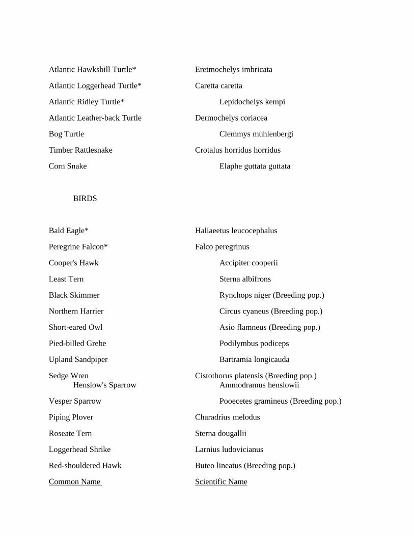
Atlantic Hawksbill Turtle* Eretmochelys imbricata
Atlantic Loggerhead Turtle* Caretta caretta
Atlantic Ridley Turtle* Lepidochelys kempi
Atlantic Leather-back Turtle Dermochelys coriacea
Bog Turtle Clemmys muhlenbergi
Timber Rattlesnake Crotalus horridus horridus
Corn Snake Elaphe guttata guttata
BIRDS
Bald Eagle* Haliaeetus leucocephalus
Peregrine Falcon* Falco peregrinus
Cooper's Hawk Accipiter cooperii
Least Tern Sterna albifrons
Black Skimmer Rynchops niger (Breeding pop.)
Northern Harrier Circus cyaneus (Breeding pop.)
Short-eared Owl Asio flamneus (Breeding pop.)
Pied-billed Grebe Podilymbus podiceps
Upland Sandpiper Bartramia longicauda
Sedge Wren Cistothorus platensis (Breeding pop.)Henslow's Sparrow Ammodramus henslowii
Vesper Sparrow Pooecetes gramineus (Breeding pop.)
Piping Plover Charadrius melodus
Roseate Tern Sterna dougallii
Loggerhead Shrike Larnius ludovicianus
Red-shouldered Hawk Buteo lineatus (Breeding pop.)
Common Name Scientific Name
MAMMALS
Sperm Whale* Physter catedon
Blue Whale* Balaenopetera musculus
Fin Whale* Balaenopetera physalus
Sei Whale* Balaenopetera borealis
Humpback Whale* Megaptera novaeangliae
Bobcat Lynx rufus
Eastern Woodrat Neotoma floridana
Right Black Whale Balaena glacialis
INVERTEBRATES
Mitchell's Satyr (butterfly)* Neonympha m. mitchellii
Northeastern Beach Tiger Beetle Cicindela d. dorsalis
American Burying Beetle* Nicrophorus americanus
Dwarf Wedge Mussel* Alasmidonta heteredon
N.J.A.C. 7:7E-3.38(d) - STATE LIST OF THREATENED WILDLIFE SPECIES
Federal threatened species below have been marked with an asterisk(*).
Common Name Scientific Name
AMPHIBIANS
Long-tailed Salamander Eurycea longicauda
Eastern Mud Salamander Pseudotriton montanus

REPTILES
Wood Turtle Clemmys insculpta
Northern Pine Snake Pituophis m. melanoleucusAtlantic Green Turtle* Chelonia mydas
BIRDS
Osprey Paridon haliaetus
Great Blue Heron Ardea herodias
Red-shouldered Hawk Buteo lineatus
Red-headed Woodpecker Melanerpes erthyrocephalus
Bobolink Dolichonyx oryzivorus
Savannah Sparrow Passerculus sandwichensis
Ipswich Sparrow Passerculus sandwichensis princeps
Grasshopper Sparrow Ammodramus savannarum
Yellow-crowned Night Heron Nyctanassa violacca
American Bittern Botaurus legtigimosos
Northern Goshawk Accipiter gentilis
Black Rail Laccipiter jamaicensis
Barred Owl Strix varia
Little Blue Heron Egretta caerulea
Long-eared Owl Asio otus
Cliff Swallow Hirundo pyrrhonota
The Division of Parks and Forestry is responsible for promulgating the official Endangered PlantSpecies List. Because this list is periodically revised based on new information documented bythe Department, the current list should be obtained by contacting the Division of Parks andForestry, Office of Natural Land Management, CN 404, Trenton, NJ 08625-0404. The list as
constituted on 5/15/95 follows.
ENDANGERED PLANT SPECIES LIST
Scientific Name Common Name
Aeschynomene virginica sensitive joint-vetch
Alisma triviale large water-plantain
Amaranthus pumilus sea-beach pigweed
Amelanchier sanguinea running serviceberry
Ammannia latifolia Koehn=s tooth-cup
Andromeda glaucophylla bog rosemary
Anemone cylindrica long-headed anemone
Antennaria neglecta var. canadensis Canada pussytoes
Aplectrum hyemale puttyroot
Arabis drummondii Drummond's rock cress
Arceuthobium pusillum dwarf mistletoe
Arenaria stricta rock sandwort
Aristida lanosa wooly three-awned grass
Armoracia lacustris lake cress
Asimina triloba pawpaw
Asplenium bradleyi Bradley's spleenwort
Asplenium pinnatifidum lobed spleenwort
Aster borealis rush aster
Aster firmus shining aster
Aster praealtus willow-leaved aster
Aster radula low rough aster

Athyrium pycnocarpon glade fern
Atriplex subspicata orache
Bidens beckii water-marigold
Bidens bidentoides bur-marigold
Bidens eatonii Eaton=s bur-marigold
Boltonia asteroides var. glastifolia boltonia
Botrychium multifidum leathery grape-fern
Bouteloua curtipendula side-oats gramma grass
Cacalia atriplicifolia pale indian plantain
Calamagrosatis pickeringii Pickering's reedgrass
Calystegia spithamea erect bindweed
Cardamine longii Long's bitter cress
Cardamine maxima larged-leaved toothwort
Cardamine rotundifolia round-leaved water-cress
Scientific Name Common Name
Carex alopecoidea foxtail sedge
Carex amphibola var. amphibola narrow-leaved sedge
Carex aquatilis water sedge
Carex arctata dropping woodsedge
Carex backii Back's sedge
Carex brunnescens brownish sedge
Carex bushii Bush's sedge
Carex crawei Crawe's sedge
Carex cumulata clustered sedge
Carex deweyana Dewey's sedge
Carex formosa handsome sedge
Carex haydenii cloud sedge
Carex jamesii Nebraska sedge
Carex joorii cypress-swamp sedge
Carex leptonervia finely-nerved sedge
Carex limosa mud sedge
Carex louisianica Louisiana sedge
Carex lupuliformis hop-like sedge
Carex oligocarpa few-fruited sedge
Carex peckii white-tinged sedge
Carex plantaginea plantain-leaved sedge
Carex polymorpha variable sedge
Carex pseudocyperus cyperus-like sedge
Carex siccata dry-spiked sedge
Carex tuckermanii Tuckerman's sedge
Castanea pumila Allegheny chinquapin
Centrosema virginianum spurred butterfly pea
Ceratophyllum echinatum spiny coontail
Cercis canadensis redbud
Chenopodium rubrum red goosefoot
Cinna latifolia slender wood reedgrass
Cirsium virginianum Virginia thistle
Claytonia virginica var. hammondiae Hammond=s yellow spring beauty
Cleistes divaricata spreading pogonia
Clitoria mariana butterfly pea
Coelorachis rugosa wrinkled jointgrass
Commelina erecta slender dayflower
Conioselinum chinense hemlock-parsley
Cornus amomum var. schuetzeana silky dogwood
Corema conradii broom crowberry
Crataegus calpodendron pear hawthorn
Crataegus succulenta fleshy hawthorn
Cryptogramma stelleri slender rock-brake
Scientific Name Common Name
Cuscuta cephalanthii button-bush dodder
Cuscuta indecora collared dodder
Cynoglossum virginianum var. boreale northern wild comfrey
Cyperus hystricinus flatsedge
Cyperus plukenetii Plukenet=s flatsedge
Cyperus polystachyos coast flatsedge
Cyperus pseudovegetus marsh flatsedge
Cyperus refractus reflexed flatsedge
Cyperus retrofractus rough flatsedge
Cyperus schweinitzii Schweinitz=s flatsedge
Cyperus tenuifolius low flatsedge
Cypripedium candidum small white lady's-slipper
Cypripedium reginae showy lady's-slipper
Dalibarda repens robin-run-away
Desmodium humifusum trailing tick-trefoil
Desmodium pauciflorum few-flowered tick-trefoil
Desmodium sessilifolium sessile-leaved tick-trefoil
Dicentra canadensis squirrel-corn
Dicentra eximia wild bleeding-hearts
Diodia virginiana larger buttonweed
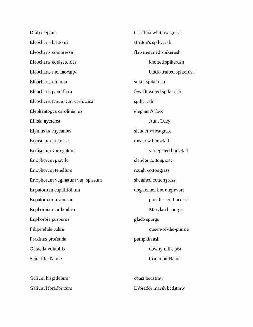
Draba reptans Carolina whitlow-grass
Eleocharis brittonii Britton's spikerush
Eleocharis compressa flat-stemmed spikerush
Eleocharis equisetoides knotted spikerush
Eleocharis melanocarpa black-fruited spikerush
Eleocharis minima small spikerush
Eleocharis pauciflora few-flowered spikerush
Eleocharis tenuis var. verrucosa spikerush
Elephantopus carolinianus elephant's foot
Ellisia nyctelea Aunt Lucy
Elymus trachycaulus slender wheatgrass
Equisetum pratense meadow horsetail
Equisetum variegatum variegated horsetail
Eriophorum gracile slender cottongrass
Eriophorum tenellum rough cottongrass
Eriophorum vaginatum var. spissum sheathed cottongrass
Eupatorium capillifolium dog-fennel thoroughwort
Eupatorium resinosum pine barren boneset
Euphorbia marilandica Maryland spurge
Euphorbia purpurea glade spurge
Filipendula rubra queen-of-the-prairie
Fraxinus profunda pumpkin ash
Galactia volubilis downy milk-pea
Scientific Name Common Name
Galium hispidulum coast bedstraw
Galium labradoricum Labrador marsh bedstraw
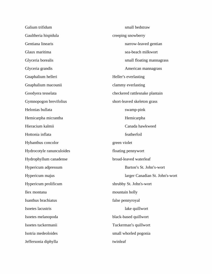
Galium trifidum small bedstraw
Gaultheria hispidula creeping snowberry
Gentiana linearis narrow-leaved gentian
Glaux maritima sea-beach milkwort
Glyceria borealis small floating mannagrass
Glyceria grandis American mannagrass
Gnaphalium helleri Heller=s everlasting
Gnaphalium macounii clammy everlasting
Goodyera tesselata checkered rattlesnake plantain
Gymnopogon brevifolius short-leaved skeleton grass
Helonias bullata swamp-pink
Hemicarpha micrantha Hemicarpha
Hieracium kalmii Canada hawkweed
Hottonia inflata featherfoil
Hybanthus concolor green violet
Hydrocotyle ranunculoides floating pennywort
Hydrophyllum canadense broad-leaved waterleaf
Hypericum adpressum Barton=s St. John=s-wort
Hypericum majus larger Canadian St. John's-wort
Hypericum prolificum shrubby St. John's-wort
Ilex montana mountain holly
Isanthus brachiatus false pennyroyal
Isoetes lacustris lake quillwort
Isoetes melanopoda black-based quillwort
Isoetes tuckermanii Tuckerman=s quillwort
Isotria medeoloides small whorled pogonia
Jeffersonia diphylla twinleaf

Juncus brachycarpus short-fruited rush
Juncus caesariensis New Jersey rush
Juncus coriaceus awl-leaved rush
Juncus elliottii Elliott's rush
Kalmia polifolia pale laurel
Krigia dandelion dwarf dandelion
Kuhnia eupatorioides false boneset
Lathyrus ochroleucus pale vetchling peavine
Lathyrus venosus smooth veiny peavine
Lechea tenuifolia slender pinweed
Lemna perpusilla minute duckweed
Lemna valdiviana pale duckweed
Liatris scariosa var. novae-angliae northern blazing star
Limosella subulata mudweed
Scientific Name Common Name
Linnaea borealis twin-flower
Linum intercursum Florida yellow flax
Linum sulcatum grooved yellow flax
Listera cordata heart-leaved twayblade
Listera smallii kidney-leaved twayblade
Lobelia boykinii Boykin's lobelia
Lobelia dortmanna water lobelia
Lonicera canadensis fly honeysuckle
Luzula acuminata hairy woodrush
Lycopodium annotinum stiff clubmoss
Maianthemum canadense var. interius Western wild lily of the valley
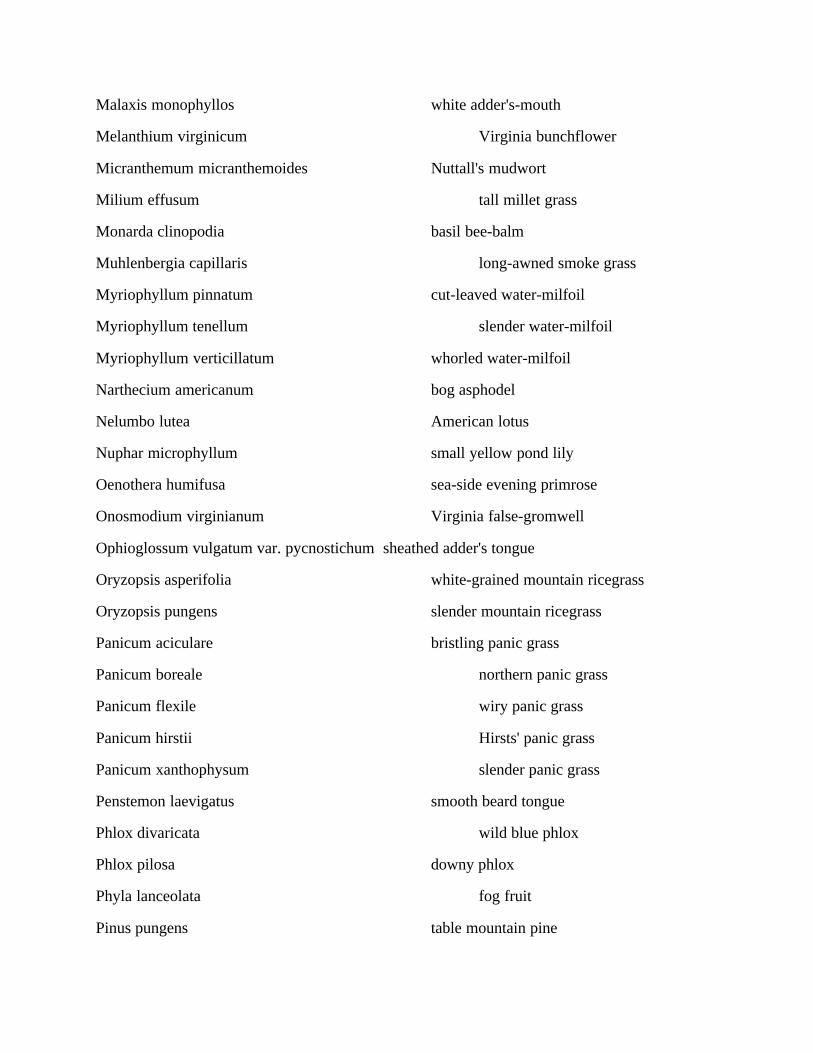
Malaxis monophyllos white adder's-mouth
Melanthium virginicum Virginia bunchflower
Micranthemum micranthemoides Nuttall's mudwort
Milium effusum tall millet grass
Monarda clinopodia basil bee-balm
Muhlenbergia capillaris long-awned smoke grass
Myriophyllum pinnatum cut-leaved water-milfoil
Myriophyllum tenellum slender water-milfoil
Myriophyllum verticillatum whorled water-milfoil
Narthecium americanum bog asphodel
Nelumbo lutea American lotus
Nuphar microphyllum small yellow pond lily
Oenothera humifusa sea-side evening primrose
Onosmodium virginianum Virginia false-gromwell
Ophioglossum vulgatum var. pycnostichum sheathed adder's tongue
Oryzopsis asperifolia white-grained mountain ricegrass
Oryzopsis pungens slender mountain ricegrass
Panicum aciculare bristling panic grass
Panicum boreale northern panic grass
Panicum flexile wiry panic grass
Panicum hirstii Hirsts' panic grass
Panicum xanthophysum slender panic grass
Penstemon laevigatus smooth beard tongue
Phlox divaricata wild blue phlox
Phlox pilosa downy phlox
Phyla lanceolata fog fruit
Pinus pungens table mountain pine

Pinus resinosa red pine
Plantago pusilla slender plantain
Platanthera flava var. flava southern rein orchid
Platanthera hookeri Hooker=s orchid
Platanthera integra yellow fringeless orchid
Scientific Name Common Name
Platanthera nivea snowy orchid
Platanthera orbiculata large round-leaved orchid
Platanthera peramoena purple fringeless orchid
Pluchea foetida stinking fleabane
Poa autumnalis autumn bluegrass
Poa saltuensis bluegrass
Polemonium reptans Greek valerian
Polygala incarnata pink milkwort
Polygala senega Seneca snakeroot
Polygonum densiflorum stout smartweed
Polygonum glaucum sea-beach knotweed
Polymnia uvedalia bearsfoot
Potamogeton alpinus northern pondweed
Potamogeton confervoides algae-like pondweed
Potamogeton illinoensis Illinois pondweed
Potamogeton obtusifloius obtuse-leaved pondweed
Potamogeton praelongus white-stemmed pondweed
Potamogeton robbinsii Robbins' pondweed
Potamogeton zosteriformis flat-stemmed pondweed
Potentilla palustris marsh cinquefoil
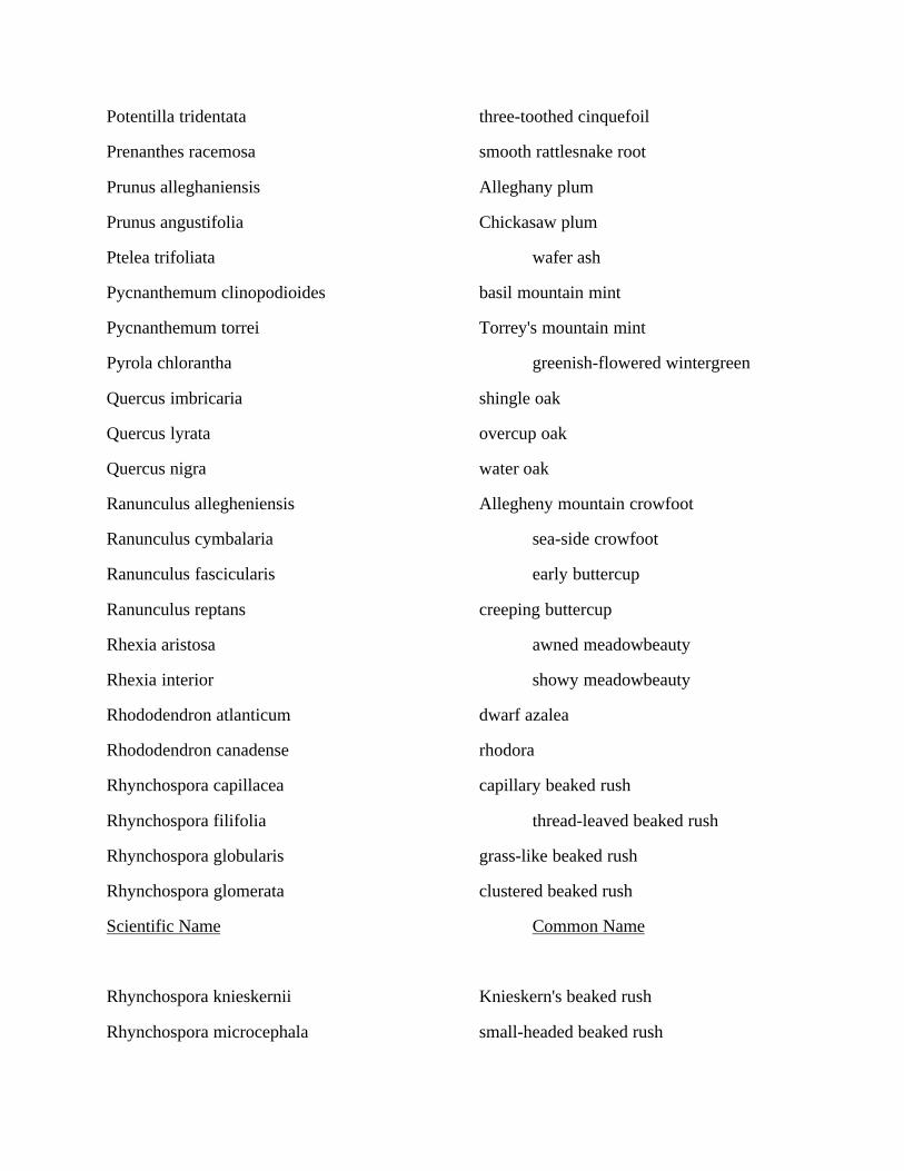
Potentilla tridentata three-toothed cinquefoil
Prenanthes racemosa smooth rattlesnake root
Prunus alleghaniensis Alleghany plum
Prunus angustifolia Chickasaw plum
Ptelea trifoliata wafer ash
Pycnanthemum clinopodioides basil mountain mint
Pycnanthemum torrei Torrey's mountain mint
Pyrola chlorantha greenish-flowered wintergreen
Quercus imbricaria shingle oak
Quercus lyrata overcup oak
Quercus nigra water oak
Ranunculus allegheniensis Allegheny mountain crowfoot
Ranunculus cymbalaria sea-side crowfoot
Ranunculus fascicularis early buttercup
Ranunculus reptans creeping buttercup
Rhexia aristosa awned meadowbeauty
Rhexia interior showy meadowbeauty
Rhododendron atlanticum dwarf azalea
Rhododendron canadense rhodora
Rhynchospora capillacea capillary beaked rush
Rhynchospora filifolia thread-leaved beaked rush
Rhynchospora globularis grass-like beaked rush
Rhynchospora glomerata clustered beaked rush
Scientific Name Common Name
Rhynchospora knieskernii Knieskern's beaked rush
Rhynchospora microcephala small-headed beaked rush
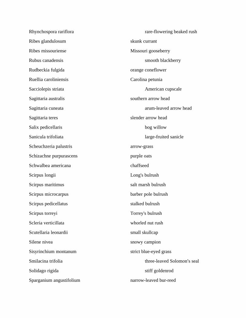
Rhynchospora rariflora rare-flowering beaked rush
Ribes glandulosum skunk currant
Ribes missouriense Missouri gooseberry
Rubus canadensis smooth blackberry
Rudbeckia fulgida orange coneflower
Ruellia caroliniensis Carolina petunia
Sacciolepis striata American cupscale
Sagittaria australis southern arrow head
Sagittaria cuneata arum-leaved arrow head
Sagittaria teres slender arrow head
Salix pedicellaris bog willow
Sanicula trifoliata large-fruited sanicle
Scheuchzeria palustris arrow-grass
Schizachne purpurascens purple oats
Schwalbea americana chaffseed
Scirpus longii Long's bulrush
Scirpus maritimus salt marsh bulrush
Scirpus microcarpus barber pole bulrush
Scirpus pedicellatus stalked bulrush
Scirpus torreyi Torrey's bulrush
Scleria verticillata whorled nut rush
Scutellaria leonardii small skullcap
Silene nivea snowy campion
Sisyrinchium montanum strict blue-eyed grass
Smilacina trifolia three-leaved Solomon=s seal
Solidago rigida stiff goldenrod
Sparganium angustifolium narrow-leaved bur-reed

Sparganium minimum small bur-reed
Sphagnum augustifolia sphagnum
Sphagnum austinii sphagnum
Sphagnum centrale sphagnum
Sphagnum contortum sphagnum
Sphagnum macrophyllum var. floridanum sphagnum
Sphagnum platyphyllum sphagnum
Sphagnum riparium sphagnum
Sphagnum strictum sphagnum
Sphagnum subsecundum sphagnum
Spiranthes laciniata lace-lip ladies'-tresses
Sporobolus neglectus puff-sheathed dropseed
Stachys palustris var. homotricha marsh hedge-nettle
Stellaria borealis northern stichwort
Scientific Name Common Name
Stellaria pubera star chickweed
Streptopus amplexifolius white twisted-stalk
Streptopus roseus rosy twisted-stalk
Stylisma pickeringii Pickering=s morning-glory
Suaeda rollandii sea blight
Thuja occidentalis northern white cedar
Tiarella cordifolia foamflower
Tofieldia racemosa false asphodel
Triadenum walteri Walter's St. John's-wort
Trichomanes sp. l filmy fern
Tridens chapmanii Chapman's redtop

Triglochin maritimum sea-side arrow-grass
Triosteum augustifolium narrow-leaved tinker's-weed
Triphora trianthophora three birds orchid
Trollius laxus ssp. laxus spreading globe flower
Utricularia biflora two-flowered bladderwort
Utricularia minor lesser bladderwort
Utricularia olivacea dwarf white bladderwort
Utricularia resupinata reversed bladderwort
Uvularia puberula var. nitida pine barren bellwort
Valerianella radiata beaked corn-salad
Valerianella umbilica corn-salad
Verbena simplex narrow-leaved vervain
Vernonia glauca broad-leaved ironweed
Veronica catenata speedwell
Viburnum alnifolium witch hobble
Vicia caroliniana Carolina wood vetch
Viola canadensis Canada violet
Viola septentrionalis northern blue violet
Vitis novae-angliae New England grape
Vulpia elliotea squirrel fescue
Wolffiella floridana Florida bogmat
Xyris caroliniana sand yellow-eyed grass
Xyris fimbriata fringed yellow-eyed grass
Xyris montana northern yellow-eyed grass
Zigadenus leimanthoides oceanorus

FEDERAL AND STATE WILDERNESS AREAS
AREA: N.J.A.C. 7:1E-1.8(a)16, Federal and State wilderness areas, including areasincluded within the Natural Areas System or the State Register of Natural Areas pursuant to theNatural Areas System Act, N.J.S.A. 13:1B-15.12a et seq. and 15.4 et seq., and N.J.A.C. 7:5A-1.13, and preserved land held by the New Jersey Natural Lands Trust pursuant to the New JerseyNatural Lands Trust Act, N.J.S.A. 13:1B-15.119 et seq.
ENVIRONMENTAL IMPORTANCE: Federal and State wilderness areas are important forrecreational activities such as hiking and camping. They are also host to a variety of plant andanimal life. Therefore, these areas are of both cultural and ecological importance.
CITATIONS: The Natural Areas System Act, N.J.S.A. 13:1B-15.12a, states that for inclusion inthe natural areas system, it is not necessary that an area be wholly unmarked by man, but that theimpact of man be not permanent, not seriously destructive of the area's potential for developingnatural values, and not obtrusively apparent to the casual observer, and is of such character thatthe lessening of human impact will allow the land or water to recover natural values of interest.Lands subject to the noise of vehicular traffic and of commercial and industrial operations, andsubject to air and water pollution as the result of the activities of man, may be designated as partsof the system if they lie on the perimeters of primary natural areas within the system, and if thepurpose of their inclusion within the system is to protect or buffer the primary natural areas.
N.J.S.A. 13:1B-15.4 defines "natural areas" as areas of land or water which have retained theirprimeval character, although not necessarily completely natural and undisturbed, or having rareor vanishing species of plant and animal life or having similar features of interest which areworthy of preservation for the use of present and future residents of the State.
N.J.A.C. 7:5A-1.3 contains the following definitions:
"Natural area" means an area of land or water, owned in fee simple or held as a conservationeasement by the Department, which has retained its natural character, although not necessarilycompletely undisturbed, or having rare or vanishing species of plant and animal life, or havingsimilar features of interest, which are worthy of preservation for present and future residents ofthe State.
"Natural Areas System" means those lands designated as natural areas purusant to this

subchapter, identified at N.J.A.C. 7:5A-1.13, and consisting of lands that serve as habitat for rareplant species or animal species, or both, or are representative of natural communities.
To be placed on the Register of Natural Areas, a site must be an endangered species habitat, anatural community, or a wildlife habitat. An endangered species habitat must be verified assupporting a significant, viable natural occurrence of one or more plant or animal species, orboth, determined to be rare, threatened, or endangered in the State or the United States. A naturalcommunity supports a significant, viable example of a rare natural community or is an extremelyhigh quality representative of other natural communities of New Jersey. Quality includes, but isnot limited to, characteristics of structure, composition, age, size and degree of disturbance. Awildlife habitat provides spawning, breeding, nesting, resting, or feeding habitat which is highlysignificant for supporting resident or migratory wildlife, or both, of the State, the United States,or the world.
Interim classifications for natural areas, as found in N.J.A.C. 7:5A-1.7, fall into one of twocategories:
1. Ecological reserve: an area managed to allow natural processes to proceed withlittle or no habitat manipulation;
2. Conservation preserve: an area where habitat manipulation is permissible in orderto preserve a plant or animal species, community type, or ecosystem;
The following are designated in N.J.A.C. 7:5A-1.13 as components of the Natural Areas System:
Absegami Natural Area
Location: Bass River State Forest, Bass River Township, Burlington County
Management Objective: preservation of Atlantic white cedar and pine/oak communities,southern swamp habitat, and rare species habitat
Interim Classification: conservation preserve
Administering Agency: Division of Parks and Forestry, through Bass River State Forest
Allamuchy Natural Area

Location: Allamuchy State Park, Allamuchy Township, Warren County, and Byram Township,Sussex County
Management Objective: preservation of a hardwood forest of significant size and successionalfields and protection of a rare plant community
Interim Classification: conservation preserve
Administering Agency: Division of Parks and Forestry, through Hopatcong State Park
Batsto Natural Area
Location: Wharton State Forest, Mullica Township, Atlantic County, and Washington Township,Burlington County
Management Objective: preservation of a southern swamp, Pine Barrens bog and floodplainhabitats, and rare species habitat
Interim Classification: conservation preserve
Administering Agency: Division of Parks and Forestry, through Wharton State Forest
Bearfort Mountain Natural Area
Location: Wawayanda State Park, West Milford Township, Passaic County
Management Objective: preservation of scrub oak and hardwood swamp forests, and rare specieshabitat
Interim Classification: conservation preserve
Admistering Agency: Division of Parks and Forestry, through Wawayanda State Park
Bear Swamp East Natural Area
Location: Downe Township, Cumberland County
Management Objective: preservation of ecological communities and relationships, managementof bald eagle nesting site and other known and potential endangered species habitat
Interim Classification: ecological reserve
Administering Agency: Division of Parks and Forestry, through the Office of Natural LandsManagement
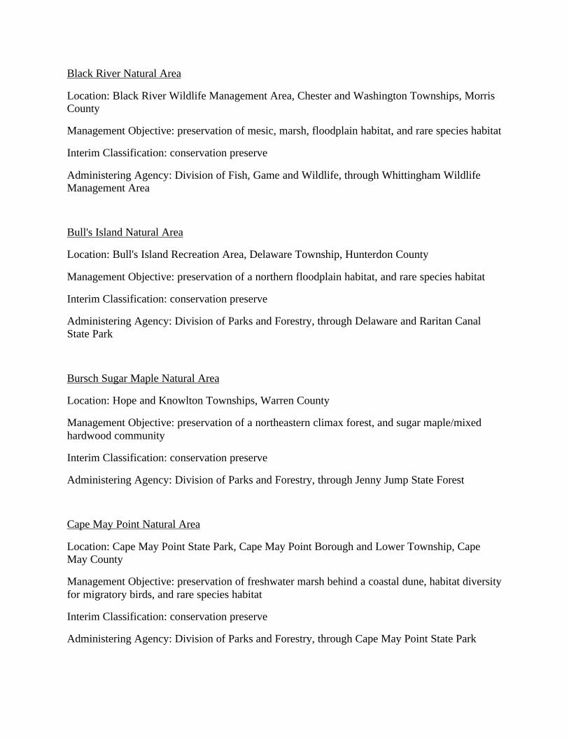
Black River Natural Area
Location: Black River Wildlife Management Area, Chester and Washington Townships, MorrisCounty
Management Objective: preservation of mesic, marsh, floodplain habitat, and rare species habitat
Interim Classification: conservation preserve
Administering Agency: Division of Fish, Game and Wildlife, through Whittingham WildlifeManagement Area
Bull's Island Natural Area
Location: Bull's Island Recreation Area, Delaware Township, Hunterdon County
Management Objective: preservation of a northern floodplain habitat, and rare species habitat
Interim Classification: conservation preserve
Administering Agency: Division of Parks and Forestry, through Delaware and Raritan CanalState Park
Bursch Sugar Maple Natural Area
Location: Hope and Knowlton Townships, Warren County
Management Objective: preservation of a northeastern climax forest, and sugar maple/mixedhardwood community
Interim Classification: conservation preserve
Administering Agency: Division of Parks and Forestry, through Jenny Jump State Forest
Cape May Point Natural Area
Location: Cape May Point State Park, Cape May Point Borough and Lower Township, CapeMay County
Management Objective: preservation of freshwater marsh behind a coastal dune, habitat diversityfor migratory birds, and rare species habitat
Interim Classification: conservation preserve
Administering Agency: Division of Parks and Forestry, through Cape May Point State Park
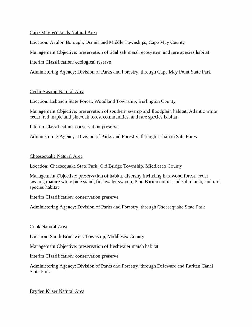
Cape May Wetlands Natural Area
Location: Avalon Borough, Dennis and Middle Townships, Cape May County
Management Objective: preservation of tidal salt marsh ecosystem and rare species habitat
Interim Classification: ecological reserve
Administering Agency: Division of Parks and Forestry, through Cape May Point State Park
Cedar Swamp Natural Area
Location: Lebanon State Forest, Woodland Township, Burlington County
Management Objective: preservation of southern swamp and floodplain habitat, Atlantic whitecedar, red maple and pine/oak forest communities, and rare species habitat
Interim Classification: conservation preserve
Administering Agency: Division of Parks and Forestry, through Lebanon Sate Forest
Cheesequake Natural Area
Location: Cheesequake State Park, Old Bridge Township, Middlesex County
Management Objective: preservation of habitat diversity including hardwood forest, cedarswamp, mature white pine stand, freshwater swamp, Pine Barren outlier and salt marsh, and rarespecies habitat
Interim Classification: conservation preserve
Administering Agency: Division of Parks and Forestry, through Cheesequake State Park
Cook Natural Area
Location: South Brunswick Township, Middlesex County
Management Objective: preservation of freshwater marsh habitat
Interim Classification: conservation preserve
Administering Agency: Division of Parks and Forestry, through Delaware and Raritan CanalState Park
Dryden Kuser Natural Area
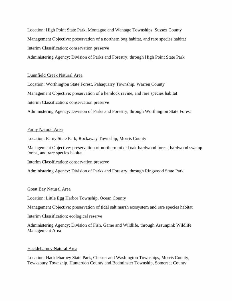
Location: High Point State Park, Montague and Wantage Townships, Sussex County
Management Objective: preservation of a northern bog habitat, and rare species habitat
Interim Classification: conservation preserve
Administering Agency: Division of Parks and Forestry, through High Point State Park
Dunnfield Creek Natural Area
Location: Worthington State Forest, Pahaquarry Township, Warren County
Management Objective: preservation of a hemlock ravine, and rare species habitat
Interim Classification: conservation preserve
Administering Agency: Division of Parks and Forestry, through Worthington State Forest
Farny Natural Area
Location: Farny State Park, Rockaway Township, Morris County
Management Objective: preservation of northern mixed oak-hardwood forest, hardwood swampforest, and rare species habitat
Interim Classification: conservation preserve
Administering Agency: Division of Parks and Forestry, through Ringwood State Park
Great Bay Natural Area
Location: Little Egg Harbor Township, Ocean County
Management Objective: preservation of tidal salt marsh ecosystem and rare species habitat
Interim Classification: ecological reserve
Administering Agency: Division of Fish, Game and Wildlife, through Assunpink WildlifeManagement Area
Hacklebarney Natural Area
Location: Hacklebarney State Park, Chester and Washington Townships, Morris County,Tewksbury Township, Hunterdon County and Bedminster Township, Somerset County

Management Objective: preservation of a river ravine and northern hemlock/mixed hardwoodforest, and rare species habitat
Interim Classification: conservation preserve
Administering Agency: Division of Parks and Forestry, through Hacklebarney State Park
Island Beach Northern Natural Area
Location: Island Beach State Park, Berkeley Township, Ocean County
Management Objective: preservation of barrier island dune system, plant communityassociations, and rare species habitat
Interim Classification: ecological reserve
Administering Agency: Division of Parks and Forestry, through Island Beach State Park
Island Beach Southern Natural Area
Location: Island Beach State Park, Ocean and Berkeley Townships, Ocean County
Management Objective: preservation of barrier island dune system, saltwater marsh, freshwaterbogs, and rare species habitat
Interim Classification: conservation preserve
Administering Agency: Division of Parks and Forestry, through Island Beach State Park
Johnsonburg Natural Area
Location: Frelinghuysen Township, Warren County
Management Objective: preservation of habitat diversity for rare species
Interim Classification: ecological reserve
Administering Agency: Division of Parks and Forestry, through Jenny Jump State Forest
Ken Lockwood Gorge Natural Area
Location: Ken Lockwood Gorge Wildlife Management Area, Lebanon Township, HunterdonCounty
Management Objective: preservation of hemlock/mixed hardwood forest with highly varied
understory, and rare species habitat
Interim Classification: conservation preserve
Administering Agency: Division of Fish, Game and Wildlife, through Whittingham WildlifeManagement Area
Liberty Park Natural Area
Location: Liberty State Park, Jersey City, Hudson County
Management Objective: preservation of a salt marsh in Upper New York Bay
Interim Classification: conservation preserve
Administering Agency: Division of Parks and Forestry, through Liberty State Park
Manahawkin Natural Area
Location: Manahawkin Wildlife Management Area, Stafford Township, Ocean County
Management Objective: preservation of a mature bottomland hardwood forest, and rare specieshabitat
Interim Classification: ecological reserve
Administering Agency: Division of Fish, Game and Wildlife, through Assunpink WildlifeManagement Area
North Brigantine Natural Area
Location: City of Brigantine, Atlantic County
Management Objective: preservation of salt marsh habitat, coastal dune, and rare species habitat
Interim Classification: conservation preserve
Administering Agency: Division of Parks and Forestry, through Wharton State Forest
Osmun Forest Natural Area
Location: Knowlton Township, Warren County
Management Objective: preservation of a northeastern mixed hardwood forest
Interim Classification: ecological reserve
Administering Agency: Division of Parks and Forestry, through Jenny Jump State Forest
Oswego River Natural Area
Location: Wharton State Forest, Washington and Bass River Townships, Burlington County
Management Objective: preservation of a hardwood swamp, pitch pine lowland, pine-oak,Atlantic white cedar, and bog communities, which serve as rare species habitat
Interim Classification: ecological reserve
Administering Agency: Division of Parks and Forestry, through Wharton State Forest
Parvin Natural Area
Location: Parvin State Park, Pittsgrove Township, Salem County
Management Objective: preservation of mixed oak and pine forest on the Pine Barrens fringewith a diversity of plant and animal species, and rare species habitat
Interim Classification: conservation preserve
Administering Agency: Division of Parks and Forestry, through Parvin State Park
Ramapo Lake Natural Area
Location: Ramapo Mountain State Forest, Wanaque and Ringwood Boroughs, Passaic County,and Oakland Borough, Bergen County
Management Objective: preservation of northern upland habitats and rare species habitat
Interim Classification: conservation preserve
Administering Agency: Division of Parks and Forestry, through Ringwood State Park
Rancocas Natural Area
Location: Rancocas State Park, Westampton Township, Burlington County
Management Objective: preservation of freshwater marsh and southern floodplain habitat,including one of the largest stands of wild rice in the State
Interim Classification: conservation preserve
Administering Agency: Division of Parks and Forestry, through Lebanon State Forest
Readington Natural Area
Location: Readington Township, Hunterdon County
Management Objective: preservation of early stages of secondary field succession
Interim Classification: conservation preserve
Administering Agency: Division of Parks and Forestry, through Round Valley Recreation Area,for the New Jersey Natural Lands Trust
Strathmere Natural Area
Location: Corson's Inlet State Park, Upper Township, Cape May County
Management Objective: preservation of a dune habitat, plant community associations, and rarespecies habitat
Interim Classification: conservation preserve
Administering Agency: Division of Parks and Forestry, through Belleplain State Forest
Sunfish Pond Natural Area
Location: Worthington State Forest, Pahaquarry Township, Warren County
Management Objective: preservation of a lake of glacial origin surrounded by a hardwood forest,and rare species habitat
Interim Classification: ecological reserve
Administering Agency: Division of Parks and Forestry, through Worthington State Forest
Swan Point Natural Area
Location: Brick Township, Ocean County
Management Objective: preservation of tidal salt marsh ecosystem
Interim Classification: ecological reserve
Administering Agency: Division of Parks and Forestry, through Island Beach State Park
Swimming River Natural Area
Location: Borough of Tinton Falls, Monmouth County
Management Objective: preservation of habitat diversity including freshwater marsh, saltwatermarsh, woodlands, fields and estuary
Interim Classification: conservation preserve
Administering Agency: Division of Parks and Forestry, through Allaire State Park
Tillman Ravine Natural Area
Location: Stokes State Forest, Walpack and Sandyston Townships, Sussex County
Management Objective: preservation of a hemlock ravine and associated geologic forms, andrare species habitat
Interim Classification: conservation preserve
Administering Agency: Division of Parks and Forestry, through Stokes State Forest
Troy Meadows Natural Area
Location: East Hanover and Parsippany-Troy Hills Townships, Morris County
Management Objective: preservation of freshwater marsh habitat northern swamp and floodplainhabitat, and rare species habitat
Interim Classification: conservation preserve
Administering Agency: Division of Parks and Forestry, through Ringwood State Park
Washington Crossing Natural Area
Location: Washington Crossing State Park, Hopewell Township, Mercer County
Management Objective: preservation of natural succession and mixed hardwood forests, and rarespecies habitat
Interim Classification: conservation preserve
Administering Agency: Division of Parks and Forestry, through Washington Crossing State Park
Wawayanda Hemlock Ravine Natural Area
Location: Wawayanda State Park, Vernon Township, Sussex County
Management Objective: preservation of hemlock/mixed hardwood forest and rare species habitat
Interim Classification: conservation preserve
Administering Agency: Division of Parks and Forestry, through Wawayanda State Park
Wawayanda Swamp Natural Area
Location: Wawayanda State Park, Vernon Township, Sussex County, and West MilfordTownship, Passaic County
Management Objective: preservation of extensive northern swamp and forest habitats, glaciallyformed, spring-fed pond, and rare species habitat
Interim Classification: conservation preserve
Administering Agency: Division of Parks and Forestry, through Wawayanda State Park
West Pine Plains Natural Area
Location: Bass River State Forest, Woodland Township, Burlington County
Management Objective: preservation of a significant portion of the globally rare Pine Plainscommunity, including rare plant and invertebrate species habitat
Interim Classification: conservation preserve
Administering Agency: Division of Parks and Forestry, through Bass River State Forest
Whittingham Natural Area
Location: Whittingham Wildlife Management Area, Fredon Township, Sussex County
Management Objective: preservation of a northern swamp and floodplain forest on a limestonecliff, rare and exemplary natural communities, and rare species habitat
Interim Classification: conservation preserve
Administering Agency: Division of Fish, Game and Wildlife, through Whittingham WildlifeManagement Area
The New Jersey Natural Lands Trust Act, N.J.S.A. 13:1B-15.119, created and established in butnot of the Division of Parks and Forestry, a body corporate and politic with corporate succession,to be known as the New Jersey Natural Lands Trust. The statutory goals of the trust include thepreservation of land in its natural state for enjoyment by the public and to protect elements ofnatural diversity.
The lands currently owned or held by the New Jersey Natural Lands Trust are as follows:
ATLANTIC COUNTY
Clarks Landing Preserve, Galloway Township
Costa Preserve, Hamilton Township
Danenhauer Preserve, Hamilton Township
Folsom Preserve, Folsom Borough
Hamilton Preserve, Hamilton Township
Heathercroft Preserve, Egg Harbor Township
Pomona Woods, Hamilton Township
BURLINGTON COUNTY
Five Pines, Bass River Township
Holly Ford Ice Preserve, Mount Holly Township
Moorestown Project Areas, Moorestown
Taylor Wildlife Preserve, Cinnaminson Township
CAMDEN COUNTY
Four Mile Branch, Winslow Township
CAPE MAY COUNTY
Frye Preserve, Middle Township
Stacherski Project Area, Ocean City
Shorebird Preserves:
Cape May County Agreement, Middle and Lower Townships
Carl and Evelyn Foster property, Middle Township (7.7 acres)
Charles and Lida Foster property, Middle Township (7.2 acres)
John Jarvis property, Middle Township (6 acres)
Shivers Agreement, Middle Township (114 acres)
Tolz Easement, Middle Township (12.5 acres)
CUMBERLAND COUNTY
Sharps Branch, City of Vineland
Shorebird Preserves:
Environmental Concern, Inc., property, Maurice River Township, (10.4 ares)
Orr property, Maurice River Township, (43 acres)
ESSEX COUNTY
Iris Construction Preserve, Fairfield
GLOUCESTER COUNTY
Big Timber Creek Preserve, Deptford Township
Collings Pines, Monroe Township
Monroe Preserve, Monroe Township
Squankum Branch Preserve, Monroe Township
HUNTERDON COUNTY
Collins Easement, Stockton Township
Isenburger Preserve, Lebanon Township
Readington Preserve, Readington Township
MERCER COUNTY
Curlis Lake Easement, Hopewell Township
Highfields Easement, Hopewell Township
MIDDLESEX COUNTY
Stevens Easement, Edison Township
MONMOUTH COUNTY
Whale Pond Brook Preserve, Eatontown Borough and Ocean Township
MORRIS COUNTY
Primrose Brook Preserve, Harding Township

OCEAN COUNTY
Audubon Easement, Berkeley Township
Barnegat Preserve, Barnegat Township
Crossley Preserve, Berkeley Township and Manchester Township
Double Trouble Preserve, Lacey Township
Kislow Preserve, Stafford Township
Lacey Project Area, Lacey Township
Lazarus Preserve, Stafford Township
Lin-Lee Preserve, Barnegat Township
Mystic Island Preserve, Little Egg Harbor Township
West Plains Preserve, Barnegat Township
SOMERSET COUNTY
Flemer Preserve, Franklin Township
SUSSEX COUNTY
Bufanio, Stillwater Township
Crooked Swamp Caves Preserve, Lafayette Township
Congleton Wildlife Sanctuary, Hardyston, Wantage and Lafayette Township
Elm Spring Preserve, Wantage
McCarthy Preserve, Hopatcong
Reinhardt Preserve, Montague Township
Wallkill River Project Area, Sparta
WARREN COUNTY
Earl Brugler Preserve, Blairstown Township
Limestone Ridge Marsh Preserve, Blairstown Township
AREAS DESIGNATED AS WILD, SCENIC, RECREATIONAL, OR DEVELOPEDRECREATIONAL RIVERS
AREA: N.J.A.C. 7:1E-1.8(a)17, Areas designated as wild, scenic, recreational, ordeveloped recreational rivers, pursuant to the National Wild and Scenic Rivers Act, 16 U.S.C.1271 et seq., or the New Jersey Wild and Scenic Rivers Act, N.J.S.A. 13:8-45 et seq.
ENVIRONMENTAL IMPORTANCE: These areas are culturally and ecologicallyimportant. They contain plant, animal and fish life, and are used for recreational activities suchas boating, swimming and fishing.
CITATIONS: The National Wild and Scenic Rivers Act, 16 U.S.C. 1271 et seq., states thatcertain selected rivers of the Nation which, with their immediate environments, possessoutstanding remarkable scenic, recreational, geologic, fish and wildlife, historic, cultural or othersimilar values, shall be preserved in free flowing condition, and that they and their immediateenvironments shall be protected for the benefit and enjoyment of present and future generations.
A wild, scenic or recreational river area eligible to be included in the system is a free-flowingstream and the related adjacent land area that possesses one or more of the values referred toabove. Every wild, scenic or recreational river in its free-flowing condition, or upon restorationto this condition, shall be considered eligible for inclusion in the national wild and scenic riverssystem and, if included, shall be classified, designated, and administered as one of the following:
(1) Wild river areas - Those rivers or sections of rivers that are free of impoundments andgenerally inaccessible except by trail, with watersheds or shorelines essentially primitive andwaters unpolluted. These represent vestiges of primitive America.
(2) Scenic river areas - Those rivers or sections of rivers that are free of impoundments, withshorelines or watersheds still largely primitive and shorelines largely undeveloped, but
accessible in places by roads.
(3) Recreational river areas - Those rivers or sections of rivers that are readily accessible byroad or railroad, that may have some development along their shorelines, and that may haveundergone some impoundment or diversion in the past.
The following rivers and the land adjacent thereto are designated as components of the nationalwild and scenic rivers system as of 1991:
Delaware, New York, Pennsylvania, and New Jersey - The segment from the point where theriver crosses the northern boundary of the Delaware Water Gap National Recreation Area tothe point where the river crosses the southern boundary of such recreation area.
When the Secretary of the Interior designates a river as wild, scenic or recreational, notice ispublished in the Federal Register.
The New Jersey Wild and Scenic Rivers Act, N.J.S.A. 13:8-45 et seq. states that the New JerseyWild and Scenic Rivers System shall comprise river areas classified, designated andadministered as wild, scenic, recreational or developed recreational rivers. These areas aredelineated in N.J.A.C. 7:7E-3.46 as follows:
Wild rivers areas, which are those rivers, or sections thereof, that are free of impoundment andgenerally inaccessible except by trail, with watersheds or shorelines essentially primitive andundeveloped and waters unpolluted. Wild river areas are also consistent with Natural Areas.
Scenic river areas, which are those rivers, or sections thereof, that are free of impoundment, withwatersheds or shorelines still largely primitive and undeveloped, but accessible in places by road.
Recreational river areas, which are those rivers, or sections thereof, that are readily accessible,that may have some development along their shorelines, and that may have undergone someimpoundment or diversion.
Developed recreational rivers, which are those rivers, or sections thereof, that are readily
accessible, that may have substantial development along their shorelines, that may haveundergone substantial impoundment or diversion, but which remain suitable for a variety ofrecreational uses.
Each classification has a unique set of standards which specify the type of land and water usespermitted or prohibited in order to maintain the quality of the designated river area.
The Lower Atsion segment of the Mullica River is designated as a Wild River Component to theNew Jersey Wild and Scenic Rivers System. This designated river area includes the delineatedflood prone area and adjacent state owned lands as presented on the Official Map of the LowerAtsion Wild River Segment. The segment begins at the Central Railroad of New Jersey bridgedownstream of Route 206 near Atsion, and ends at the nature trail footbridge near Batsto Village,including a portion of the Great Swamp Segment of the Batsto Natural Area.
Upon designation of a river area into the New Jersey Wild and Scenic Rivers System, notice,including a map portraying the boundaries of the river area, is published in the New JerseyRegister.