Embed Size (px)
Citation preview
Goulburn Mulwaree Development Control Plan
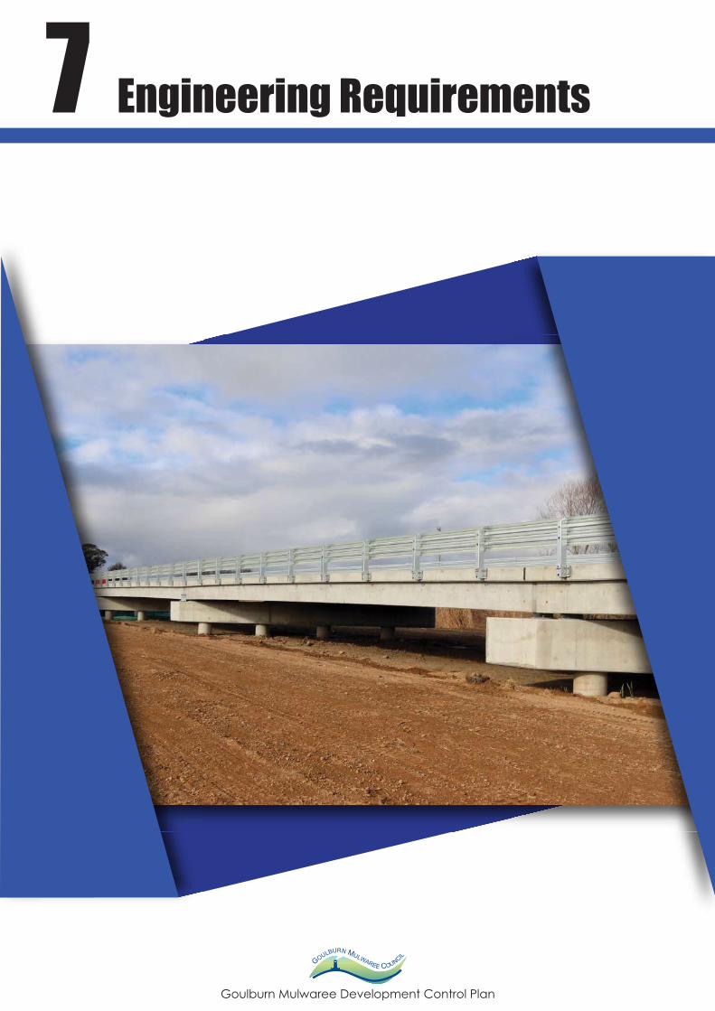
7 Engineering Requirements
Goulburn Mulwaree Development Control Plan 2009
Goulburn Mulwaree DCP 2009 – Last Amended 23 August 2018
Contents
7 ENGINEERING REQUIREMENTS 1
7.1 Utility services 1
7.2 Roads 1
7.2.1 Urban 1
7.2.2 Rural 3
7.2.3 Heavy vehicle haulage development routes 3
7.3 Drainage and soil and water management 6
7.3.1 Drainage (urban) 6
7.3.2 Water sensitive urban design (urban) 7
7.3.3 Soil and water management 8
7.4 Easements 10
7.5 Staging of development in urban release areas 10
Goulburn Mulwaree Development Control Plan 2009
Goulburn Mulwaree DCP 2009 – Last Amended 23 August 2018 Page | 1
7 Engineering requirements
Engineering requirements under part 7 of this plan apply to all development, including
subdivision, where permissible within the Goulburn Mulwaree local government area.
7.1 Utility services
Objectives
To provide satisfactory utility services to the development site.
Controls
Applicants are to provide connections to the following services where available to the site
– water, sewerage, gas, telephone and electricity, on site.
Applicants are advised to liaise with the AGL (gas), Telstra (telephone), Country Energy
(electricity) and Council (water and sewer) or other accredited provider as to the
availability of these services, prior to submission of development applications.
Sewerage and water supply design to be in accordance with the Standards for
Engineering Works, July 1996. Rainwater tanks are to be provided in accordance with
Council Policy.
Council is not averse to applicants supplying their own power supply, provided that
Country Energy approve the alternate power source.
Council may require as a condition of its consent, prior to release of Certificates or plans,
that satisfactory arrangements be made for the provision of a reticulated electricity
supply, telephone services and a reticulated natural gas supply.
7.2 Roads
7.2.1 Urban
a) Roads
Objectives
To ensure all roads are designed and constructed in accordance with the current version
of Council's Standards for Engineering Works.
Goulburn Mulwaree Development Control Plan 2009
Goulburn Mulwaree DCP 2009 – Last Amended 23 August 2018 Page | 2
Controls
Council's Standards for Engineering Works shall apply to new subdivisions and dual
occupancy and multi dwelling housing developments.
Residential development shall be designed to:
ensure satisfactory and safe operation within the adjacent road system
take into account water sensitive road design practices
have regard to contours and avoid large cuts and fills, steep slopes, prominent
hilltops and creeks
avoid long dead ends and cul-de-sac heads on the down slope end of roads
ensure that drainage lines are not impeded
stabilise, replant and/or top dress exposed batters and table drains and improve
slope stability on all earthworks
when using rear public and private laneways for vehicle access in dual occupancy
and multi dwelling housing development the engineering design shall:
- make provision for bitumen sealed laneway construction, the provision of
passing bays, drainage, sediment control etc. from the development site to
the closest public road. In the event that the above requirements cannot be
achieved, for whatever reason the laneway is not to be used and access is to
be provided from the public road frontage.
All proposed road, splay and road widening shall be dedicated to Council, free of cost as
public roads.
Where the design of the access road involves realignment, provided the Council agrees
to acquire any adjoining land, which may be necessary to effect such realignment, the
applicant shall bear full cost of such acquisition.
The use of decorative paving such as brick, interlocking pavers or coloured concrete is
encouraged as these materials can enhance the appearance of the street and signify to
motorists its residential function and corresponding appropriate driver behaviour.
Where cul-de-sacs are included in road design, when all other options are considered,
alternative cul-de-sac heads that may be considered are square offset, T-Heads and Y-
Heads. Include appropriate traffic calming devices on the collector roads.
Roads should be placed between houses and open space areas/vegetation conservation
areas to provide a buffer separation for fire management and vegetation preservation
along with passive surveillance benefits.
Goulburn Mulwaree Development Control Plan 2009
Goulburn Mulwaree DCP 2009 – Last Amended 23 August 2018 Page | 3
7.2.2 Rural
Controls
All proposals are to be designed and constructed to comply with the current version of
Council’s Standards for Engineering Works for rural roads, drainage, erosion and
sediment control and other special facilities covered in the standard.
Proposed road reserve width of 20 metres.
General road provisions
Subdivision proposals, including new roads and Crown roads to be transferred as public
roads to Council, must front and connect to a bitumen sealed two lane road designed and
constructed in accordance with the current version of Council’s Standards for Engineering
Works.
Access via a right of carriage way shall be limited to one lot and constructed to an all-
weather pavement standard.
7.2.3 Heavy vehicle haulage development routes
Objectives
To set out the matters to be considered for selection of haulage routes for heavy vehicle
haulage developments to address rural and village amenity and safety
To set out road standards for heavy vehicle haulage routes
To identify the road standard and haulage route information required to be submitted with
an application for heavy vehicle haulage development.
Controls
Route selection for heavy vehicle haulage developments
Principal haulage routes needs to be nominated when submitting a development
application for a heavy vehicle haulage development.
The applicant needs to justify selection of the haulage route based upon traffic
engineering grounds, amenity considerations and availability of alternative options (i.e.
rail). If the existing road network is unsatisfactory then upgrades will be required.
The following matters should be addressed in a development application:
1) Impact on the road network:
Existing traffic movements along the haulage route.
Goulburn Mulwaree Development Control Plan 2009
Goulburn Mulwaree DCP 2009 – Last Amended 23 August 2018 Page | 4
Estimated increase in traffic movements resulting from the proposed
development. This includes detail of any staging proposal, truck / car ratio and
the life of the project / development.
Foreseeable increases in traffic movements resulting from other known
development (i.e. subdivision of land etc).
Heavy vehicle type and volume (i.e. rigid or articulated, covered or uncovered).
Anticipated tonnage of material to be transported.
Type of material transported.
Hours of operation and frequency of movements.
2) Impact on amenity and the environment – Rural, Village Zones and generally:
Proximity of haulage route to residence, community land etc.
Community expectation including ambience and enjoyment of life.
Community assets including accessibility to parks by residents and visitors.
Noise generation.
Vibration generation.
Visual impact.
Pedestrian safety and safety of other road uses.
Impact on roadside habitat resulting from road upgrade works.
Consistency with the objectives of all zones that the haulage route passes
through.
An applicant may also wish to include details of voluntary measures that are proposed to
be undertaken during the operational phase of the development to address any of the
considerations outlined in this section. This could include a heavy vehicle code of practice
whereby drivers of heavy vehicles agree not to exceed a particular speed limit on a
haulage route for safety reasons. Selection of such measures can be informed through
discussion with Council staff and/or the responses generated from any consultation
undertaken by the applicant prior to submitting an application.
Goulburn Mulwaree Development Control Plan 2009
Goulburn Mulwaree DCP 2009 – Last Amended 23 August 2018 Page | 5
Haulage Route standards for heavy vehicle haulage developments
The following road standard for haulage routes is required:
7m wide sealed carriageways in rural areas
In addition to the carriageway, 1m wide shoulders on each side with a 500mm
seal
80km/h design standard
9m wide culverts and bridges (i.e. from barrier to barrier).
Minimum remaining pavement life of 10 years at the time of commencement of
operations
Asphaltic concrete surface in village areas.
Note: Intersection upgrades may also be required to accommodate turning paths for
heavy vehicles.
Information to accompany an application for development involving heavy vehicle
haulage should establish the existing road condition and include an assessment of the
remaining pavement life. This assessment should be undertaken by an appropriately
qualified professional and should factor in the estimated additional load to be generated
by the heavy vehicle haulage development and the resulting impact on the existing road.
Design traffic should be calculated in equivalent standard axles (ESAs).
The following information should be submitted with an application for heavy vehicle
haulage development:
Pavement testing results for the intended haulage route/s;
An estimation of the remaining pavement life of all intended haulage routes given
the anticipated additional load from the proposed development; and
A plan and/or schedule identifying any upgrades required to the pavement to
ensure that the road has a minimum pavement life of 10 years taking into account
the additional load.
Council may vary the road standard and development application information
requirements described above subject to consideration of the following:
the number of proposed heavy vehicle movements
the volume of material to be hauled
the intended life of the development
the condition of the road/s
Goulburn Mulwaree Development Control Plan 2009
Goulburn Mulwaree DCP 2009 – Last Amended 23 August 2018 Page | 6
any arrangement proposed in a development application to address ongoing road
repairs and maintenance whether by financial or in-kind contributions.
If such a variation is sought an applicant should:
discuss the matter with Council staff prior to lodging a development application
(pre-lodgement meetings are available on request); and
include justification for the variation and any alternative arrangement in the
Statement of Environmental Effects based on the matters for Council
consideration outlined above.
Note: The arrangements for developer contributions to fund the ongoing maintenance of
heavy vehicle haulage routes (once the upgrades required for the development are in
place) is provided for in the Goulburn Mulwaree Section 94 Plan.
For heavy vehicle haulage developments involving a large volume of heavy vehicle
movements, it may be appropriate that a Voluntary Planning Agreement is established in
which the haulage routes are maintained by the developer to appropriate industry
standards. This Agreement could be in lieu of a heavy vehicle contribution under the
Goulburn Mulwaree Section 94 Plan.
7.3 Drainage and soil and water management
7.3.1 Drainage (urban)
Objectives
Prevent erosion and local flooding.
Ensure adequate drainage facilities are provided within the site to collect and carry
stormwater to external systems.
Provide water quality management systems which ensure that disturbance to natural
steam systems is minimised and stormwater discharge to service and underground
receiving waters, both during construction and in developed catchments, does not
degrade the quality of water in the Wollondilly River and Mulwaree Ponds.
Retain where possible roof water on-site.
Controls
Adequate measures designed in accordance with the current version of Council’s
Standards for Engineering Works, must be made during construction to ensure the land is
stabilised and erosion is controlled, until the site is satisfactorily landscaped.
Goulburn Mulwaree Development Control Plan 2009
Goulburn Mulwaree DCP 2009 – Last Amended 23 August 2018 Page | 7
A plan identifying the location of stabilisation methods such as stacked hay bales and
sedimentation fences or geotech fabric may be required by Council prior to the release of
any plans.
Applicant shall have regard to the Stormwater Management Plan, April 2000. A copy is
available for perusal at Council.
Relevant matters to be considered are:
urban run-off
interlot drainage
design criteria
erosion sedimentation
floodways and retention basins
stormwater runoff from roofs and paved areas is to be collected on-site and retained
where appropriate or disposed of to the street drainage system, drainage easement,
natural drainage course or infiltration trenches to the satisfaction of Council.
7.3.2 Water sensitive urban design (urban)
Principles of water sensitive urban design to be incorporated into subdivision design.
Development must comply with the neutral or beneficial effect on water quality test State
Environmental Planning Policy (Sydney Drinking Water Catchment) 2011.
Drainage lines are to focus on the “natural” or existing drainage lines and integrated into
the open space network.
Drainage design is to minimise run off into vegetation conservation areas to assist with
ongoing preservation.
Detentions basins are required upstream of development (eg. Marys Mount Road) to
regulate and control the runoff back to rates equal with “natural” runoff. Detention basins
may also be required to regulate and control runoff to rates equal with “natural” runoff.
Detention ponds and other stormwater treatment devices are to be “offline” and “at
source” to ensure stormwater runoff is treated prior to entering these areas.
Use of rainwater tanks will assist with minimising runoff associated with minor rainfall
events.
Stormwater drainage systems are to be designed in accordance with the current version
of Council’s Engineering Standards for Engineering Works.
The piped drainage system to be designed for a 1 in 5 year storm event. Higher order
storms events to be based on overland flow systems along “natural” drainage lines.
Goulburn Mulwaree Development Control Plan 2009
Goulburn Mulwaree DCP 2009 – Last Amended 23 August 2018 Page | 8
7.3.3 Soil and water management
Objective
To minimise soil erosion and water pollution by minimising land disturbance and requiring
control measures on-site.
To ensure the potential impacts of development on the water quality of the catchment can
be quantified and evaluated in the context of Ecologically Sustainable Development.
Controls
Development proposals where the area of disturbance is less than 2500m² require an
Erosion and Sediment Control Plan (ESCP) (written document and site diagrams) that
indicates measures to minimise erosion and sedimentation.
Development proposals where the area of disturbance is 2500m² or greater should be
accompanied by a Soil and Water Management Plan (SWMP) (written document and site
diagrams), prepared by a suitably qualified person(s), that clearly identifies the
constraints of soil erosion, sediment pollution and stormwater pollution.
The SWMP should contain appropriate Best Management Practices that recognise site
constraints and support ESD principles. The plan should include:
soil conservation and pollution/nutrient control measures to be installed prior to
clearing and earthworks and maintained until landscaping measures are complete
protection measures for site access and exits
catchment drainage characteristics of existing and proposed drainage patterns
protection of existing overland flow paths, watercourses, stormwater kerb inlets and
drains.
upslope clean surface runoff diversions around the disturbed areas
staggered site works to minimise disturbance
rehabilitation and stabilisation of the disturbed areas
measures to minimise the impacts of agricultural practices (such as the use of
fertilisers, cultivation practices, tree clearing and pasture management)
The SWMP should detail means to achieve no net increase in pollution of downstream
waters through the use of Best Management Practices.
The Plan should balance the management of runoff between farm dam storage and the
needs of the downstream environment.
Development of slopes greater then 20% should be avoided. Lands with slopes greater
than 20% and having soil landscapes with a moderate to high soil erosion hazard are
considered as sensitive areas. Development should minimise disturbance to these areas
Goulburn Mulwaree Development Control Plan 2009
Goulburn Mulwaree DCP 2009 – Last Amended 23 August 2018 Page | 9
by minimising areas of cut and fill to depths of 1m. Development proposals within these
areas should be accompanied by:
an evaluation of the site stability (i.e. a geotechnical report)
a schedule of earthworks
details or appropriate construction techniques
Plant species which are non-invasive to bushland should be used in landscaping and soil
and water management works.
All development proposals on potentially agricultural land should be accompanied by an
assessment of the agricultural capability of soils on the property and the effect of the
development on the agricultural capability of these soils on the property and the effect of
the development on the agricultural capability of these soils.
Goulburn Mulwaree Development Control Plan 2009
Goulburn Mulwaree DCP 2009 – Last Amended 23 August 2018 Page | 10
7.4 Easements
a) Easements
Easements shall be required pursuant to section 88B of the Conveyancing Act 1919, as
follows:
sewerage and water supply easements shall be created over all existing and
proposed sewer and water lines
where applicable, easements for batter and support shall be created over lots in
accordance with approved engineering plans
all existing and proposed rights of carriageway shall be legalised
easements for electricity purposes, if required, shall be created over existing and
proposed electricity lines
drainage reserves (or easements in exceptional circumstances) shall be created over
proposed stormwater drainage lines (including floodways), in accordance with the
Council’s standards
easements and reserves shall be dedicated to Council free of cost and appropriately
indicated on the plan of subdivision
The final plan of survey and other associated instruments plus six copies, suitable for
registration with the NSW Land and Property Information, shall be submitted to Council
for endorsement prior to the development commencing operation.
7.5 Staging of development in urban release areas
The Section applies to development within the Common Street, Clyde Street, Long Street
(Charles Valley) and Ducks Lane urban release areas.
a) Council will allow staged development in the subject urban release areas only if
Council is satisfied that:
i. adequate arrangements have been made by any developer with Council for
the provision of infrastructure and services of sewerage, water, road,
landscape and stormwater drainage; and
ii. the developer will pay for all infrastructure costs generated by their
development.
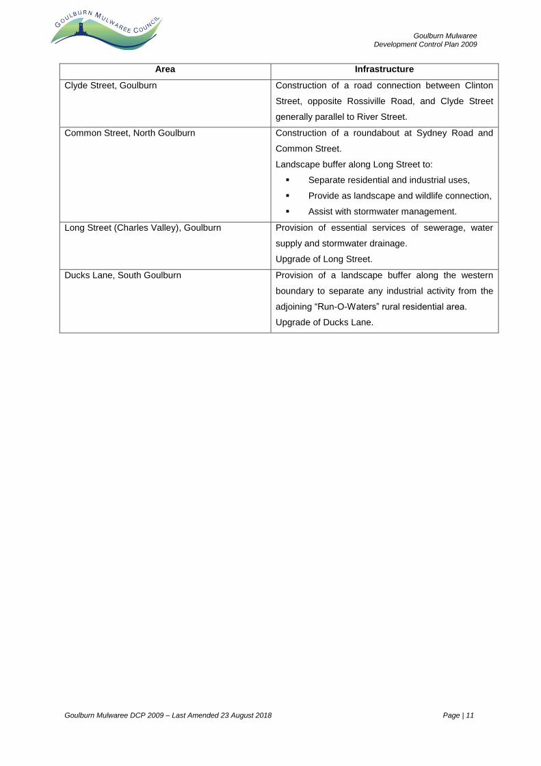
b) The areas identified in the table to this sub-clause must make provision for the
specific infrastructure identified in the table in addition to other general matters
specified under (a).
c)
Goulburn Mulwaree Development Control Plan 2009
Goulburn Mulwaree DCP 2009 – Last Amended 23 August 2018 Page | 11
Area Infrastructure
Clyde Street, Goulburn Construction of a road connection between Clinton
Street, opposite Rossiville Road, and Clyde Street
generally parallel to River Street.
Common Street, North Goulburn Construction of a roundabout at Sydney Road and
Common Street.
Landscape buffer along Long Street to:
Separate residential and industrial uses,
Provide as landscape and wildlife connection,
Assist with stormwater management.
Long Street (Charles Valley), Goulburn Provision of essential services of sewerage, water
supply and stormwater drainage.
Upgrade of Long Street.
Ducks Lane, South Goulburn Provision of a landscape buffer along the western
boundary to separate any industrial activity from the
adjoining “Run-O-Waters” rural residential area.
Upgrade of Ducks Lane.