Embed Size (px)
Citation preview


Enabling You To Do More With Your Imagery!
• Easy To Use Online System
• Use Your Current Computer
• Smart Visualization Tools
• On-Demand Decisions
• Risk Assessment Tool

• Visualize Your Plots From The Sky
• See What You May Be Missing
• Use Your Own Drone Or A Consultant’s
• Upload Imagery To Our Secure Website
• We Take It From There
• Harness The Power Of Data & Map Sharing
• Early Season Vigor
• Canopy Closure
• Senescence
• Stand Count
• Plant Height
• Tassel Counts (Investigating)
• Corn Ear Heights (Investigating)
• Crop Quality Assessment
• Pest Pressure
• Water Stress
• Chlorophyll Content
• Weed Pressure (Investigating)
Drone Imagery Can Show You:

Use This Imagery In Your Research Program:
• Visualize Emergence And Seedling Vigor
• Replant Areas With Low Emergence
• Collect Unbiased Assessments Of Crop Quality Early And Often
• Standardize Measurements Of Plant Height
• Monitor Canopy Closure And Senescence
• Measure Flowering Amount And Intensity
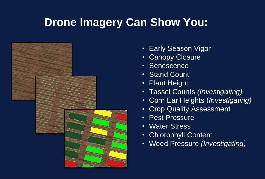
We Help Interpret Your Imagery & Provide You
With A Decision Support Tool.
• Small Plot Assessments
• Georeferenced Imagery
• Research Grade
• Fully Exportable
• Intuitive Dashboard
• Data Visualization
• Data Exploration
• Plot & Treatment Summaries
• Data Hub

• Smart Legends & Visualization Tools
• Custom Plot Digitization
• Geo-Registration
• Robust Calibration/Data Integrity
• Plot And Treatment Level Statistics
• On-Demand Comparisons
• Data Export Simplicity
• Data Hub For All Plant Assessments – In
Development
• Custom Data Summary and Report
Generation at the Dashboard – In
Development
We Manage Data So
You Don’t Have To

Optimize Your Research Program & Maximize
Your Return
Reduce Labor Intensive Field Operations
Increase Revenue/Add New Clients
Reduce Field Loss
Standardized Data Management
Streamline & Easy Reporting
$5,000 TurfScout Service
$0 Owned Drone
$2,500 Consultant Drone
$7,500 or less Estimated Cost
POTENTIAL GAIN > $3, 000

• Intuitive Map Interface
• Data Driven Map Legends
• High Quality Data Processing
• Extra – Ordinary Image Quality
• High Resolution Georeferencing On All Images
• No Minimum PC Requirements – Entirely Cloud Based
• We Clean Your Data For Free
• We Support A Wide Range Of Camera Types
• Set Fees - No Hidden Charges
No One Is More Committed To Your Success!
What Sets Us Apart From The Rest?

GET STARTED TODAY IN 5 SIMPLE STEPS
• Email Us Your Course Boundaries Or Maps
• Capture Drone Imagery
• Upload Your Imagery To Our Website
• See/Download Your Data And Maps Same Day*
• Securely Share Data With Others
*Results may vary depending on the size of your upload.