Embed Size (px)
Citation preview

21-Feb-08/ESRI Federal User Conference©2008 BAE Systems. Export controlled information 1
Enabling the Image Analyst (IA) to use the geodatabase
Rick Racine, BAE Systems, Reston, VA Stewart Walker, BAE Systems, San Diego, CA
2008 ESRI® Federal User Conference, Washington, D.C., 21 February2610020508 EXPORT CONTROL DATA: This presentation is approved for export. The actual product and its technical information is governed by the U.S. International Traffic in Arms Regulations (ITAR) or Export Administration Regulations (EAR). The product or technical information about this product must not be transferred to a foreign person/entity without proper authorization of the U.S. Government. Violations may result in administrative, civil or criminal penalties.

21-Feb-08/ESRI Federal Users/Racine©2008 BAE Systems. 2
Outline
• Introduction• Vision• Concept• Solution• GIS background• Enhancing IA tradecraft
• SOCET GXP®: Spatial Enabled Exploitation (SEE)• Basics• Workflow
• SOCET SET® : SOCET for ArcGIS®
• GGI workflow

21-Feb-08/ESRI Federal User Conference©2008 BAE Systems. Export controlled information 3
Introduction
21-Feb-08/ESRI Federal Users/Racine©2008 BAE Systems. 4
Vision
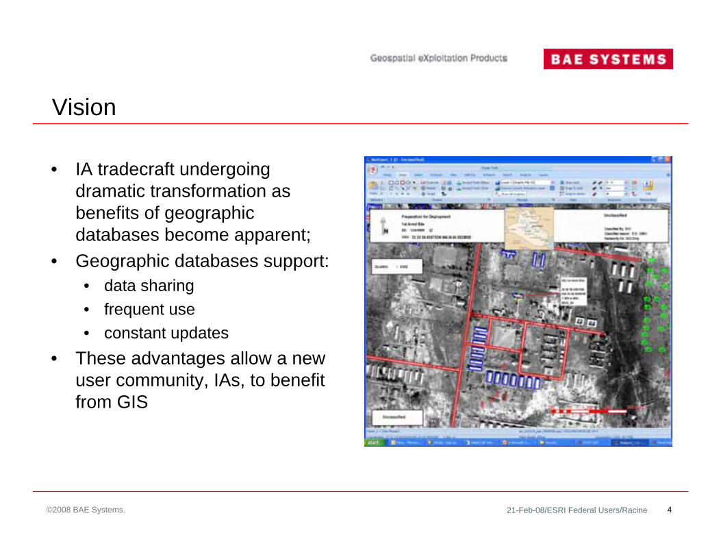
• IA tradecraft undergoing dramatic transformation as benefits of geographic databases become apparent;
• Geographic databases support:• data sharing• frequent use • constant updates
• These advantages allow a new user community, IAs, to benefit from GIS

21-Feb-08/ESRI Federal Users/Racine©2008 BAE Systems. 5
Concept
• Connect IA software to ESRI geodatabase• Geographic features stored with
accurate ground coordinates• Information queried and viewed
against new imagery, facilitating temporal analysis and change detection
• Feature attributes populated automatically or manually

21-Feb-08/ESRI Federal Users/Racine©2008 BAE Systems. 6
Solution
• BAE Systems’ SOCET GXP with SEE• Accesses geodatabase
using ArcGIS Engine• Sensor modeling capabilities
position features accurately • Supports wide range of
government and commercial image sources

21-Feb-08/ESRI Federal Users/Racine©2008 BAE Systems. 7
Solution … 2
• BAE Systems’ SOCET GXP with SEE• Intelligence observations
collected over time available to all IAs in organization through shared geodatabase
• No more sifting through historical textual reports to answer geospatial intelligence questions
• Uses production tested SOCET for ArcGIS technology

21-Feb-08/ESRI Federal Users/Racine©2008 BAE Systems. 8
GIS background
• Photogrammetry used to collect information in ground coordinates for 100 years
• Long history of interfaces between photogrammetric workstations and GIS software• Simple interfaces to analog instruments in 1970s• Interfaces to analytical plotters in 1980s, with some analytical plotters
purpose-built as GIS workstations• Interfaces to digital photogrammetric workstations in 1990s
• IA software has tendency to collect information in image coordinates• Digital equivalent of drawing on transparent overlay with Chinagraph• Vectors collected on one image don’t fit to another image
• Little history of interfaces between IA software and GIS software• No interfaces to analog light tables and zoom stereoscopes

21-Feb-08/ESRI Federal Users/Racine©2008 BAE Systems. 9
Enhancing IA tradecraft
• Current textual intelligence approach useful for reporting but not efficient for rapid analysis or collaboration
• Vectors are collected during IA product creation but are not suitable for quick retrieval based on temporal and geographic attributes
• Attributed vectors store detailed information on objects, enabling users to answer intelligence questions such as
• How many active Surface-to-Air Missiles (SAMs) are within 100 km of a specific location?
• For a specified date range and region, find all sites where SAMs were deployed• Store pertinent attributes relating to features, including:
• Dimensions, history, collection date and time, quality, precision, source, and originator
• IAs from multiple organizations express same requirement for storing intelligence observations as attributed features for subsequent query and analysis

21-Feb-08/ESRI Federal User Conference©2008 BAE Systems. Export controlled information 10
SEESolution for the IA

21-Feb-08/ESRI Federal Users/Racine©2008 BAE Systems. 11
Basics
• Concept based on 2005 paper Advocating for Spatial Storage• Concept originated by NGA GeoScout GKB-P Program• NGA ASDI program implementing SEE concept
• NGA vision: “store basic intelligence data and information in GIS-like (vector) form”• Originally known as Palette Driven Exploitation (PDE)• Promote vector-based information capture into image analysis workflow• Promote collaboration between Geospatial Analysis (GA) and Intelligence
tradecrafts• Enable various Intelligence tradecrafts to store data via common methods • Enable reuse of data to harness synergy that should be occurring between
tradecrafts• Vector-based intelligence information storage facilitates transformation of
current geospatial intelligence capabilities (text reporting)• IA/GA merge is part of raison d’être of NGA
21-Feb-08/ESRI Federal Users/Racine©2008 BAE Systems. 12
SEE workflow: geo-registration through triangulation
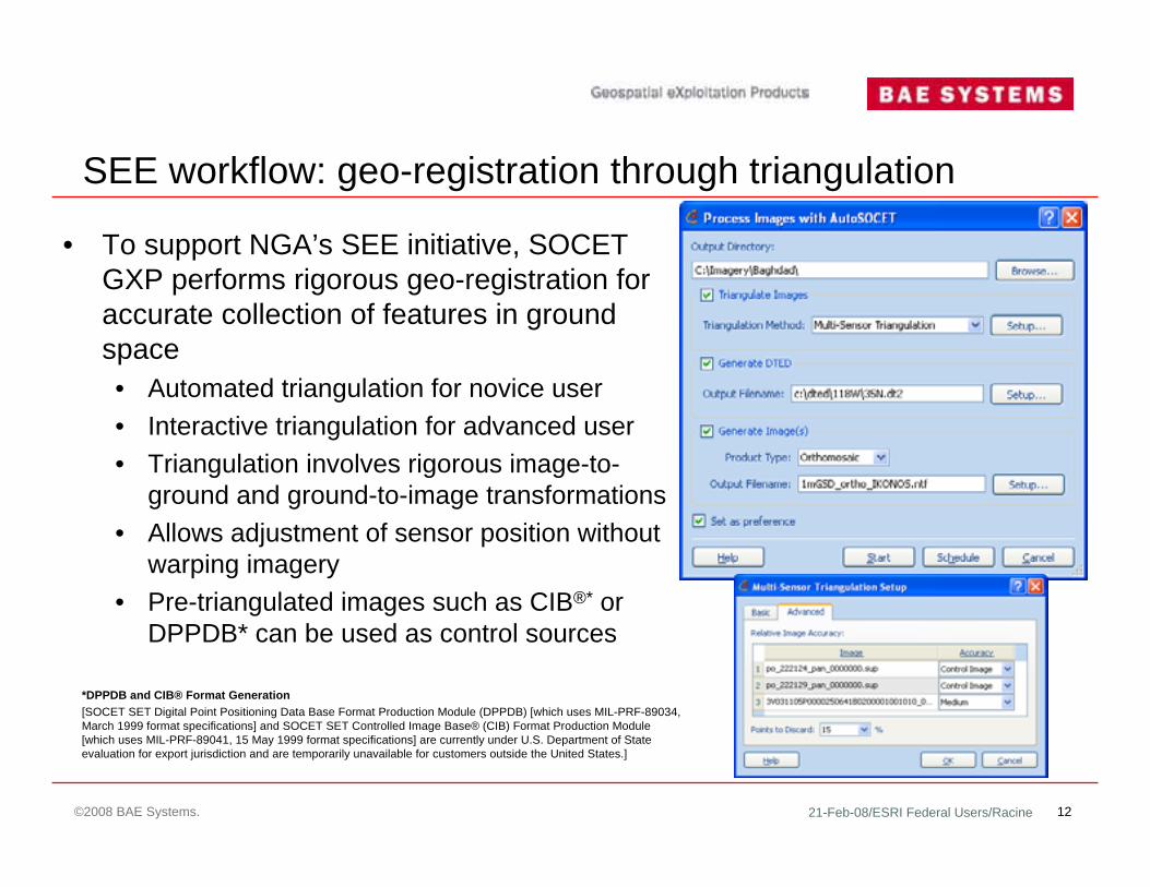
• To support NGA’s SEE initiative, SOCET GXP performs rigorous geo-registration for accurate collection of features in ground space• Automated triangulation for novice user• Interactive triangulation for advanced user• Triangulation involves rigorous image-to-
ground and ground-to-image transformations• Allows adjustment of sensor position without
warping imagery• Pre-triangulated images such as CIB®* or
DPPDB* can be used as control sources
*DPPDB and CIB® Format Generation[SOCET SET Digital Point Positioning Data Base Format Production Module (DPPDB) [which uses MIL-PRF-89034, March 1999 format specifications] and SOCET SET Controlled Image Base® (CIB) Format Production Module [which uses MIL-PRF-89041, 15 May 1999 format specifications] are currently under U.S. Department of State evaluation for export jurisdiction and are temporarily unavailable for customers outside the United States.]

21-Feb-08/ESRI Federal Users/Racine©2008 BAE Systems. 13
SEE workflow: geo-registration through triangulation … 2
• Derived from SOCET SET• User controls adjustment of image parameters• User specifies control images, control points and
terrain files for triangulation• User controls tie point patterns for automated point
measurement• Interactive tie point measurement available
• User controls strategies for solution

21-Feb-08/ESRI Federal Users/Racine©2008 BAE Systems. 14
SEE workflow: geo-registration through triangulation … 3
Today’s image
Today’s image geo-registered
Triangulation
Tomorrow’s image
Triangulation
Tomorrow’s image geo-registered
Accurate products and featuresControl
images

21-Feb-08/ESRI Federal Users/Racine©2008 BAE Systems. 15
SEE workflow: feature collection to geodatabase• Analyst connects to ESRI multi-user or personal geodatabase
• Also connects to SOCET SET or SOCET GXP feature database• Style sheet or ArcMap™ document controls feature properties
• Geodatabase appears in SOCET GXP Workspace Manager• User drags feature classes of interest on to images in Multiport viewer• Multiple geodatabase connections allowed

21-Feb-08/ESRI Federal Users/Racine©2008 BAE Systems. 16
SEE workflow: NGA feature extraction specification
• User community can define a geodatabase schema specific to intelligence reporting needs or use existing schemas• NGA ASDI and GKB-P defining
schemas for the IA user• Geodatabase and schema can be
created by administrator for IAs or alternatively, use existing

21-Feb-08/ESRI Federal Users/Racine©2008 BAE Systems. 17
SEE workflow: NGA feature extraction specification … 2
• SOCET GXP and SOCET SET provide FACC+ schema and new NGA NFDD and DFDD schema
• DFDD information at https://www.dgiwg.org/FAD/
• As in SOCET SET, new schemas can be created in SOCET GXP that comply with NGA specifications

21-Feb-08/ESRI Federal Users/Racine©2008 BAE Systems. 18
SEE workflow: feature creation and attribution
• Using ArcGIS Engine, users attribute features directly within SOCET GXP without using ArcMap canvas
• IAs record intel observations by adding new features or editing existing ones• User simply selects desired
feature class and draws it

21-Feb-08/ESRI Federal Users/Racine©2008 BAE Systems. 19
SEE workflow: feature creation and attribution … 2
• Feature appearance controlled by style sheets
• Features are drawn on image with automated attribution• Attributes can also be added
manually • Attributes can be queried to
answer intel questions, for example• Facility outlines, harbors,
beach landing zones, and mobile assets are recorded to geodatabase

21-Feb-08/ESRI Federal Users/Racine©2008 BAE Systems. 20
SEE workflow: product generation• Standard annotated IA template products
created in many formats• NITF, GeoTIFF, GeoPDF, JPEG formats
• Features collected by IA go directly into ESRI geodatabase for enterprise sharing and query
• Attributed shapefiles can also be created for those with no GIS access
• Analysts query geodatabase to view only features of interest

21-Feb-08/ESRI Federal Users/Racine©2008 BAE Systems. 21
SEE workflow: Google™ Earth connection
• Selected features with attributes are transferred from SOCET GXP into Google Earth as KML features
• Current imagery also sent into Google Earth
• Attributed features can also be sent to Google Earth using attributed shapefiles if ESRI geodatabase is unavailable
• Promotes enterprise sharing of image and attributed feature data via Google Earth

21-Feb-08/ESRI Federal Users/Racine©2008 BAE Systems. 22
SEE workflow: attribute query
• To access the power of the geodatabase, the IA has to be able to query the data in a flexible manner• Answer intel questions using
queries• Attribute, spatial, and temporal
queries can be combined• Query on any feature attribute for
a class• Results loaded in Results list tab
and SOCET GXP workspace for easy visualization

21-Feb-08/ESRI Federal Users/Racine©2008 BAE Systems. 23
SEE workflow: spatial query
• Query based on defined area• Spatial tab allows specification of
boundary• Draw boundary on image• Use images as boundaries• Use current view of image• Use feature to define boundary

21-Feb-08/ESRI Federal Users/Racine©2008 BAE Systems. 24
SEE workflow: temporal query
• Visualize changes over time• Select Temporal tab
• Date Range• On or Before a date• On or After a date
• Features that match temporal criteria can easily be visualized on image
21-Feb-08/ESRI Federal User Conference©2008 BAE Systems. Export controlled information 25
SOCET for ArcGISSolution for the GA

21-Feb-08/ESRI Federal Users/Racine©2008 BAE Systems. 26
SOCET for ArcGIS for the GA• Used by NGA and its GGI contractors
to collect 3D features from stereo imagery into ArcGIS efficiently
• User can exploit ArcMap ArcEditor ™
tools or SOCET SET tools for feature collection and editing
• ArcGIS users see practically no photogrammetry once system is initially set up
• Extends 2D ArcGIS into true 3D environment
• Tools optimized for 3D feature extraction, editing, and automatic attribution

21-Feb-08/ESRI Federal Users/Racine©2008 BAE Systems. 27
ESRI ArcMapSOCET SET
SOCET for ArcGIS: components
Geodatabase
Stereo viewing and accurate geopositioning
Functions that interact with geodatabase store/retrieve
Processing for database entries such as topology
ArcMap edit tools
SOCET SET Sketch edit tools

21-Feb-08/ESRI Federal Users/Racine©2008 BAE Systems. 28
SOCET for ArcGIS: feature extraction
• 3D features collected from SOCET SET stereo viewport directly into ArcGIS geodatabase
• All ArcMap ArcEditor tools including customer tools work within this true 3D environment

21-Feb-08/ESRI Federal Users/Racine©2008 BAE Systems. 29
SOCET for ArcGIS: feature extraction tools
• A rich set of tools for 3D feature extraction, editing, and automatic feature attribution

21-Feb-08/ESRI Federal Users/Racine©2008 BAE Systems. 30
SOCET for ArcGIS: example of GGI workflow
• Uses versioned SQL database with ArcSDE® connection to SOCET for ArcGIS
• Each extractor populates same geodatabase with QC in place• Database is populated by SOCET for ArcGIS in tandem with ESRI
PLTS and other QC tools• Can auto populate angle of orientation (AOO)• Can populate height automatically using a DEM

21-Feb-08/ESRI Federal Users/Racine©2008 BAE Systems. 31
SOCET for ArcGIS: advantages of GGI workflow
• Database such as Oracle or SQL Server does not limit database size• ArcSDE connection allows for versioning
• Dataset can be worked by multiple users at the same time• Instrumental in shortening QA/QC timelines• Data does not have to be completed before checks and edits can be made • Edge-matching issues greatly reduced due to multiple users viewing dataset
in its entirety at the same time• Dataset whole from beginning to completion of the project — no merging• Finishing procedure time reduced due to elimination of data migration — no
merging

21-Feb-08/ESRI Federal Users/Racine©2008 BAE Systems. 32
SOCET for ArcGIS: GGI workflow — quality control
• SOCET for ArcGIS opens up new QA/QC capabilities that SOCET SET Feature Extraction alone does not possess
• QC scripts run by individual extractors on limited portions of dataset or by production manager on entire dataset
• Eliminates finishing and QA/QC limitations associated with isolated databases

21-Feb-08/ESRI Federal Users/Racine©2008 BAE Systems. 33
SOCET for ArcGIS: GGI workflow – conclusions
• Production times greatly reduced• Extractors receive more timely feedback on their data, improving their
error ratios

21-Feb-08/ESRI Federal Users/Racine©2008 BAE Systems. 34
Contact informationRick Racine
(703) 668-4093 or (800) 316-9643 x3cell: (703) 472-1168
Dr. A. Stewart Walker(858) 592-1764
e-mail [email protected]/gxp