Embed Size (px)
Citation preview
Hydrography
Thank you for downloading this document. This is part of the series ‘Unusual Careers”. Lesser known careers are being researched and compiled by Mrs. Shobha Mathur. They are graciously being hosted on Karmayog.org and can be downloaded from
http://karmayog.org/careercounselling/ . This document provides valid links to various courses. All the links are working and secure as on August 2011.
For any amendment, comment, suggestion, criticism or praise, please contact me on
Unusual
Careers
Unusual Careers Hydrography
Shobha Mathur [email protected] Page 2 of 38
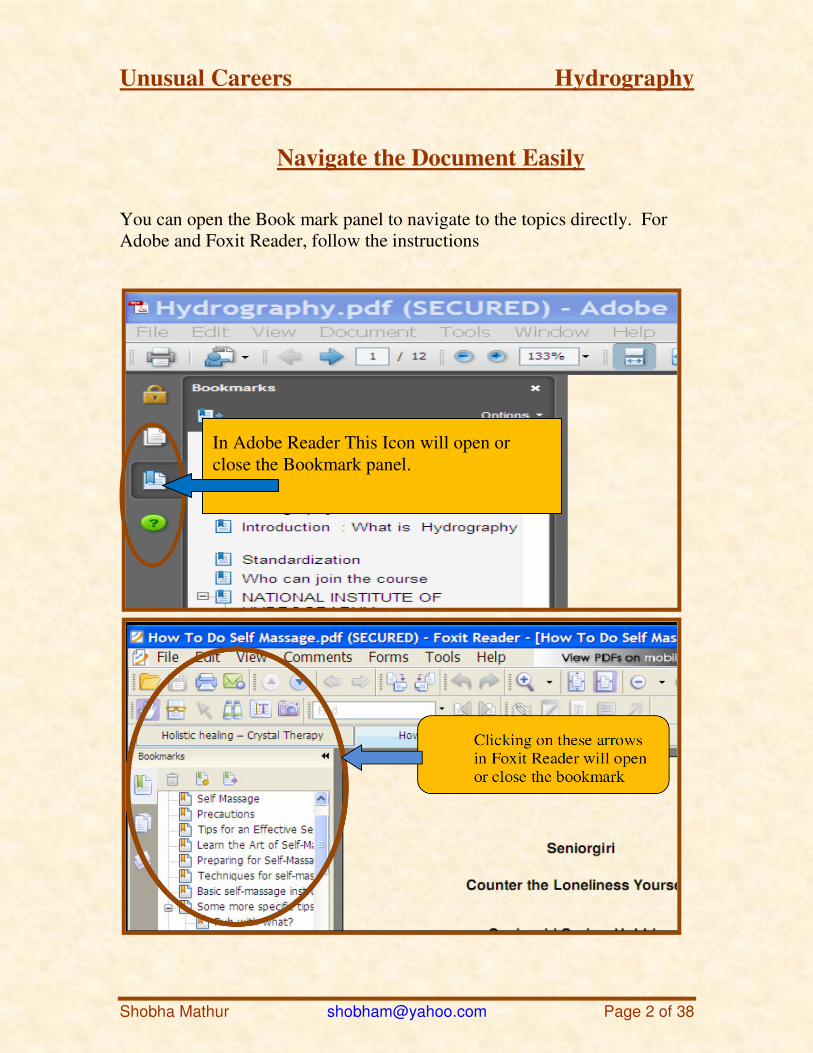
Navigate the Document Easily
You can open the Book mark panel to navigate to the topics directly. For Adobe and Foxit Reader, follow the instructions
In Adobe Reader This Icon will open or close the Bookmark panel.
Unusual Careers Hydrography
Shobha Mathur [email protected] Page 3 of 38
Hydrography
This is an updated and revised document. The information and links are correct and secure as on August 2011.
Introduction: What is Hydrography?
Hydrography is mapping of all kinds of water bodies to help in navigation.
Hydrography measures and describes all physical features over or under the water. This includes oceans, seas, coastal areas, lakes and rivers.
This not only maps existing features, but also tries to predict their evolution.
This helps safety of navigation as well as all other marine purposes and activities, including economic development, security and defense, scientific research, and environmental protection.
Many charts which were adequate a decade ago may have to be recompiled using new survey data, collected to a higher degree of accuracy and providing improved coverage.
Fortunately, new survey technologies have improved the precision to which modern hydrographic surveys can be conducted.
GIS - Geographic Information Systems and GPS is one such technology in which
In some institutes it is a part of a Survey course.
Oceanography is another related study dealing with oceans. Oceanography is a detailed study of ocean waters through waves, currents, and tides; marine life, mineral and oil deposits in the ocean bed, as well as the contours of the ocean bed. The study of oceanography is also used for the preparation of maps and charts as well as graphs.
Unusual Careers Hydrography
Shobha Mathur [email protected] Page 4 of 38
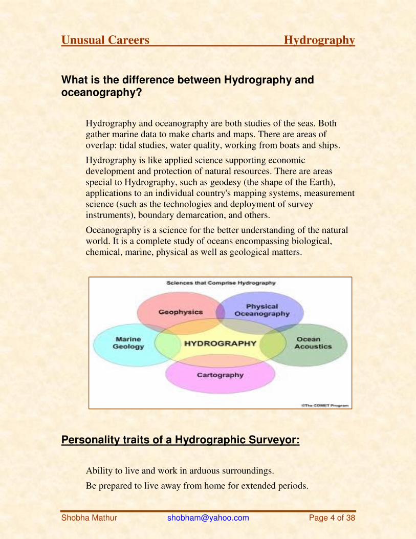
What is the difference between Hydrography and oceanography?
Hydrography and oceanography are both studies of the seas. Both gather marine data to make charts and maps. There are areas of overlap: tidal studies, water quality, working from boats and ships.
Hydrography is like applied science supporting economic development and protection of natural resources. There are areas special to Hydrography, such as geodesy (the shape of the Earth), applications to an individual country's mapping systems, measurement science (such as the technologies and deployment of survey instruments), boundary demarcation, and others.
Oceanography is a science for the better understanding of the natural world. It is a complete study of oceans encompassing biological, chemical, marine, physical as well as geological matters.
Personality traits of a Hydrographic Surveyor:
Ability to live and work in arduous surroundings.
Be prepared to live away from home for extended periods.

Unusual Careers Hydrography
Shobha Mathur [email protected] Page 5 of 38
Be available at short notices.
Meticulous attention to details.
Having the ability to maintain undivided concentration, as even slight carelessness can compromise the quality of survey.
Eligibility
Hydrography has two distinct levels of academic qualifications, technical and professional.
Surveying is the main stream of study with a specialism in Hydrography. This method of study enables the variety of career on the land or water or even a mixture of both.
Note that Surveying is also known as Geomatic Engineering and related courses are sometimes titled Spatial Information.
This is an advance course after Science / engineering streams.
A sound scientific background and the ability to be technologically savvy are highly desirable. Grounding in physics, mathematics and statistical / analytical reasoning.
The career prospects of Hydrography
Coastal Engineering
Pipeline construction
Deep Sea Mining
Seismic Surveys
Refinery Operations
Wreck/Salvage Operations
Oil and mineral Exploration
Cable Route Surveying
Field construction Dredging
Geodesy
Research and Development
Unusual Careers Hydrography
Shobha Mathur [email protected] Page 6 of 38
Hydrographic Surveyor - How to get into this job
Hydrography has two distinct levels of academic qualifications, technical and professional.
You need a University Degree in science. Surveying is the one main stream of study with a specialization in Hydrography. This method also enables the variety of career on the land or water or even a mixture of both.
Note that Surveying is also known as Geomantic Engineering and related courses are sometimes titled Spatial Information.
Many people enter the course after having worked as land surveyors or hydrographic technicians. Study done for these jobs can cut down the amount of time it takes them to qualify.
A background as a marine scientist could also lead towards a career in Hydrography, however only the hydrographic Surveying links are provided below.
Remunerations
I did not find any clue about Indian salaries. But here is a comparative chart about USA.
Entry level employee earnings - $25,100 ($12.07 hourly)
Mean employee earnings - $32,300 ($15.53 hourly)
Experienced employee earnings (upper 75% of salaries) - $42,200 ($20.29 hourly)
Unusual Careers Hydrography
Shobha Mathur [email protected] Page 7 of 38
Who can join the course
As this subject deals with marine and naval mater, this course is primarily aimed at navy personnel and mariners.
There are three categories of courses, catering for:
1. Marine cadets and Sailors
2. Marine Officers
3. Civilians.
Prominent employers
a) National Charting Agencies :
National Charting Agencies are responsible the production of nautical charts. Traditionally they used to be parts of the Navy.
But now some of the surveying work may be performed by civilian companies under contract from the Government / organization.
b) Port and Harbor Authorities :
Most major ports and harbors have a self contained survey department.
Others rely on a contracting company or a mobile team by a national port authority.
As only a small number of people are involved, openings are infrequent and state / local Government recruitment rules apply.
c) Contract Survey Companies:,
These are two kinds.
Unusual Careers Hydrography
Shobha Mathur [email protected] Page 8 of 38
Ones that only do inshore work, mainly associated with coastal engineering projects, and do not get at all involved with offshore activities.
Ones that specialize in offshore geophysical (seismic) work only.
Joining a contract survey company as a hydrographic surveyor is a common way for the newly qualified surveyor to enter the paid ranks of the profession.
d) Client Survey Companies :
These are the companies that require survey work to be carried out and contract it to a contract survey company.
They range from small port authorities to local government authorities to huge international oil companies and national government authorities.
The role of the surveyor within these organizations is to agree to the work to be done and ensure that it is carried out to the required standard and specification.
e) Freelance Surveyors and Consultants :
Self employed Freelancers and consultants are hired, at an agreed daily rate, by contract survey companies to supplement their full time employee strength.
It is not a step for the newcomer until he or she has gained considerable experience and confidence.
Consultants are specialists. They may be engaged to oversee an entire job, or to arbitrate between two or more conflicting interests.
f) Equipment and Software Companies :
Numerous service companies employ hydrographic surveyors.
These may be equipment development manufacturers and operators, and software houses.
Software packages may be developed for open commercial sale or on a contract basis for a particular client.
Unusual Careers Hydrography
Shobha Mathur [email protected] Page 9 of 38
Institutes
Courses
There are few places where you can get just Hydrography degree
or Diploma.
But many surveyor’s courses, remote sensing, and GIS -
Geographic Information System courses also cover part of this,
and graduates of these courses can also join the field.
There are several short 2 days – 2 weeks courses that such people
can take. These are not available all the time, and you may have
to search for them.
Here I have provided links to main institutes, Indian and
International for Hydrography only.
1. 'NATIONAL INSTITUTE OF HYDROGRAPHY'
In India and indeed in all South East Asia this is the only institute running courses of IHO.
There are about 10 different courses available. Out of which only three are for civilians.
I have only covered the civilian section. Navy personnel can find about the courses through their own division.
http://nih.gov.in/civilians_NHS.php
Here is the information about three civilian courses.
Unusual Careers Hydrography
Shobha Mathur [email protected] Page 10 of 38
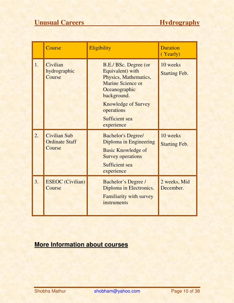
Course Eligibility Duration ( Yearly)
1. Civilian hydrographic Course
B.E./ BSc. Degree (or Equivalent) with Physics, Mathematics, Marine Science or Oceanographic background.
Knowledge of Survey operations
Sufficient sea experience
10 weeks
Starting Feb.
2. Civilian Sub Ordinate Staff Course
Bachelor's Degree/ Diploma in Engineering
Basic Knowledge of Survey operations
Sufficient sea experience
10 weeks
Starting Feb.
3. ESEOC (Civilian) Course
Bachelor’s Degree / Diploma in Electronics.
Familiarity with survey instruments
2 weeks, Mid December.
More Information about courses
Unusual Careers Hydrography
Shobha Mathur [email protected] Page 11 of 38
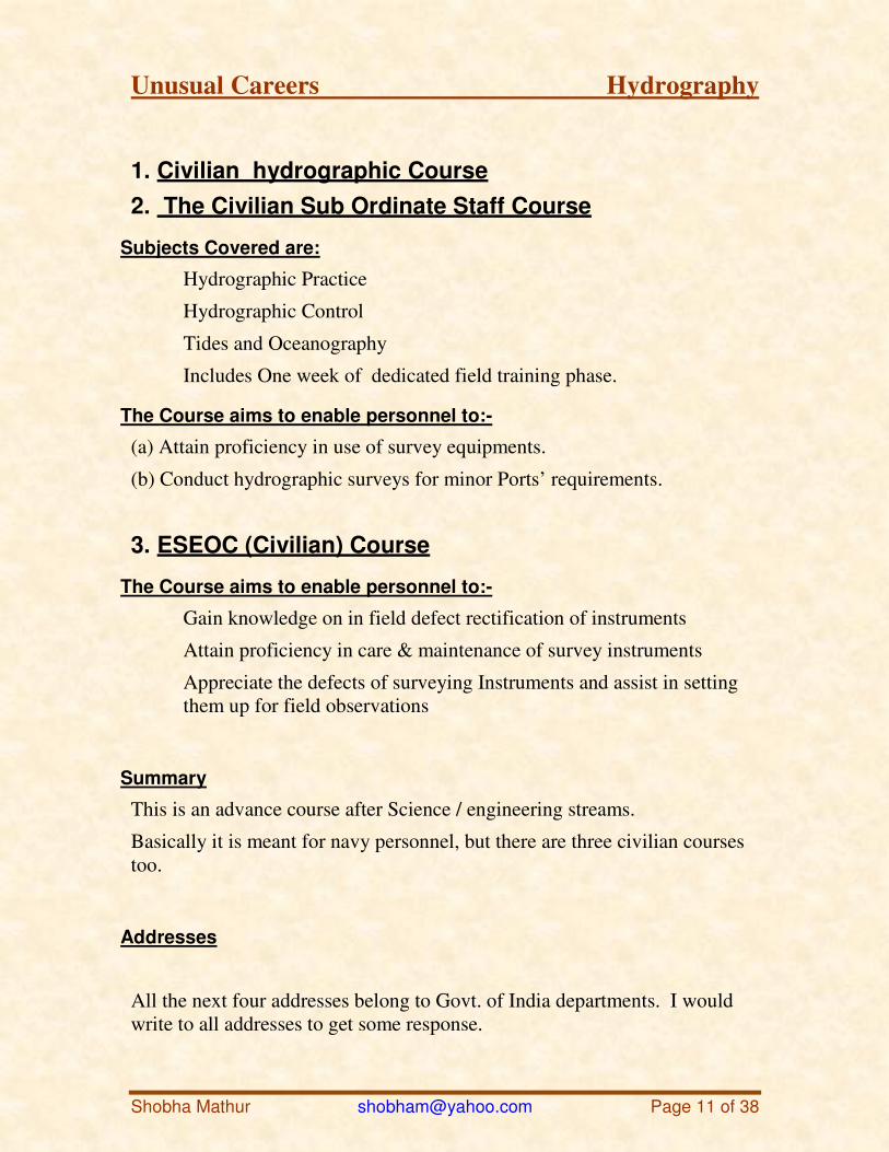
1. Civilian hydrographic Course
2. The Civilian Sub Ordinate Staff Course
Subjects Covered are:
Hydrographic Practice
Hydrographic Control
Tides and Oceanography
Includes One week of dedicated field training phase.
The Course aims to enable personnel to:-
(a) Attain proficiency in use of survey equipments.
(b) Conduct hydrographic surveys for minor Ports’ requirements.
3. ESEOC (Civilian) Course
The Course aims to enable personnel to:-
Gain knowledge on in field defect rectification of instruments
Attain proficiency in care & maintenance of survey instruments
Appreciate the defects of surveying Instruments and assist in setting them up for field observations
Summary
This is an advance course after Science / engineering streams.
Basically it is meant for navy personnel, but there are three civilian courses too.
Addresses
All the next four addresses belong to Govt. of India departments. I would write to all addresses to get some response.
Unusual Careers Hydrography
Shobha Mathur [email protected] Page 12 of 38
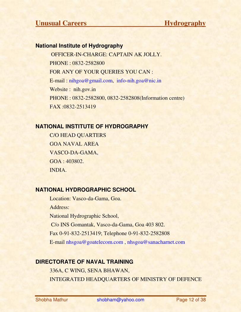
National Institute of Hydrography
OFFICER-IN-CHARGE: CAPTAIN AK JOLLY.
PHONE : 0832-2582800
FOR ANY OF YOUR QUERIES YOU CAN :
E-mail : [email protected], [email protected]
Website : nih.gov.in
PHONE : 0832-2582800, 0832-2582808(Information centre)
FAX :0832-2513419
NATIONAL INSTITUTE OF HYDROGRAPHY
C/O HEAD QUARTERS
GOA NAVAL AREA
VASCO-DA-GAMA,
GOA : 403802.
INDIA.
NATIONAL HYDROGRAPHIC SCHOOL
Location: Vasco-da-Gama, Goa.
Address:
National Hydrographic School,
C/o INS Gomantak, Vasco-da-Gama, Goa 403 802.
Fax 0-91-832-2513419; Telephone 0-91-832-2582808
E-mail [email protected] , [email protected]
DIRECTORATE OF NAVAL TRAINING
336A, C WING, SENA BHAWAN,
INTEGRATED HEADQUARTERS OF MINISTRY OF DEFENCE
Unusual Careers Hydrography
Shobha Mathur [email protected] Page 13 of 38
(NAVY)
NEW DELHI-110011
PHONE: XXX-XX-23010547 / 23793142 FAX: XXX-XX-23010319
E Mail : [email protected]
2. National Hydrographic Office
Excellent in-house Nautical Cartographic training is provided by the Cartographic experts at the National Hydrographic Office, Dehradun, towards compilation and printing of Navigational Charts and Publications, both in the conventional and digital form.
The Office conducts the following courses in nautical cartography every year.
TYPE OF COURSE DURATION
Nautical Cartography Course (Officer’s Cadre) 52 weeks
Nautical Cartography Course (Draughtsmen) 24 - 36 weeks
Applications for training may be addressed to the Chief Hydrographer to the Government of India on the Customer Request Form.
Foreign applicants may kindly apply through the normal Diplomatic Channels.
For Admission Details for civilian courses, Contact:
Joint Director of Hydrography (Personnel & Training)
National Hydrographic Office
Unusual Careers Hydrography
Shobha Mathur [email protected] Page 14 of 38
107-A Rajpur Road
Post Box # 75
Dehradun
Utarakhand-248001.
Tel +91 135 2747360 / +91 135 2747365
Fax +91 135 2748373
Email General [email protected]
Web: http://www.hydrobharat.nic.in/contact_nho.htm
http://nih.gov.in/
3. The Institute of Surveyors , Govt. of India
This also offers a course in Hydrographic Surveying along with other survey courses.
Govt. of India has recognized the pass in Final/Direct Final Examinations of Institutions of Surveyor as equivalent to degree in Engineering.
Govt. of India has also approved employment to superior posts/services of Central Govt. through UPSC (Engineering Services) for qualified surveyors from the Institution
Address
"Sarvekshan Jyoti"
B-15/7, Qutab Institutional Area,
New Mehrauli Road, New Delhi-110016
Tel. No. 011-2686-3069
011-2651-2469
Fax No. : 011-2651-2469
Web site : http://www.iosindia.org/
Unusual Careers Hydrography
Shobha Mathur [email protected] Page 15 of 38
International courses
4. University of New South Wales
BE Surveying
BE Geoinformation
Address
General Student Enquiries: School of Surveying & Spatial Information Systems The University of New South Wales Sydney NSW 2052 Australia
Phone: +61 2 9385 4182 (Int.) Fax: + 61 2 9313 7493 (Int.) Phone: (02) 9385 4182 (Australia) Fax: (02) 9313 7493 (Australia) [email protected]
International Student Enquiries: UNSW International Student Office
http://www.international.unsw.edu.au/contact-us/
5. University of Tasmania
Faculty of Science, Engineering and Technology
Bachelor of Surveying and Spatial Sciences(N3N)
http://courses.utas.edu.au/portal/page?_pageid=53,32959&_dad=portal
&_schema=PORTAL&P_COURSE_CODE=N3N&P_YEAR=2008
Course Duration: Minimum 4 yrs, Maximum 8 yrs.
This 4-year (minimum) full-time or part-time course is offered by the Interstate or overseas qualifications which are deemed equivalent by the
Unusual Careers Hydrography
Shobha Mathur [email protected] Page 16 of 38
University may also be accepted, subject to approval by the degree coordinator.
The four-year Bachelor of Surveying and Spatial Sciences course prepares graduates for professional careers in a number of closely related disciplines. These include:
Land surveying - measuring and defining land ownership boundaries; spatial control for projects such as roads and bridges;
Spatial and geographic information systems - computer management, mapping and analysis of spatial information;
Photogrammetry and remote sensing - measurement, mapping and data analysis from aircraft and satellite sensors;
Geodesy and geodetic surveying - science of the measurement and mapping of the earth's surface using satellite and terrestrial data;
Hydrographic surveying - measuring and mapping in a marine environment.
Address
Faculty of Science, Engineering & Technology
(03) 6226 2125 or Dr Volker Janssen (03) 6226 2844,
Email [email protected]
6. Skilltrade
http://www.skilltrade.nl/Default.aspx?pageid=Courses
A company that specializes in hydrographic training and courses for the hydrographic survey, dredging and offshore construction industry since 2000. Courses and training developed by people who gained their experience in the field and taught by those same individuals. The heart of the company is that the skills its people posses can be traded or exchanged with others, thus improving their hydrographic knowledge and understanding.
Skilltrade can provide courses and training in five areas by combining theoretical with field experience material:
Unusual Careers Hydrography
Shobha Mathur [email protected] Page 17 of 38
Hydrography Course –
Recognized by the International Advisory Board (formed by representatives of parent organizations: FIG, IHO and ICA) for the Category-B- Hydrography course.
Introductory and generals courses in hydrography, land survey, positioning and mathematics, depth sensors, motion sensors, survey sensors, underwater acoustics, offshore construction. Advanced courses in geophysical sensors, ROV sensors and electronic troubleshooting.
General courses in project management and change management.
ROV pilot technician training.
Survey Engineer training.
http://www.skilltrade.nl/Default.aspx?pageid=Courses
Address:
Skilltrade BV P.O. box 111 2250 AC Voorschoten The Netherlands Phone +31 (0)71 561 1365 Fax +31 (0)71 561 1503
7. University College London
Department of Civil, Environmental and Geomatic Engineering
M.Sc. Hydrography
The MSc is recognized abroad as a "Category A" programme by The International Hydrographic Organization (IHO), The International Federation of Surveyors (FIG) and The International Cartographic Association (ICA). This is the highest level of accreditation offered, and is an internationally recognized qualification that is increasingly demanded by employers worldwide. The course is also officially recognized as providing specialist training in Nautical Charting Hydrography, Hydrography to Support Port Management and Coastal Engineering, and Offshore
Unusual Careers Hydrography
Shobha Mathur [email protected] Page 18 of 38
Construction Hydrography. In addition the MSc is accredited by The Royal Institution of Chartered Surveyors and a satisfactory performance on the programme will grant you an exemption from the RICS's final written examinations
http://www.cege.ucl.ac.uk/teaching/postgraduate/hydrographic_surveying
Address
Admissions and General Enquiries Office
Department of Civil, Environmental and Geomatic Engineering
University College London Gower Street London WC1E 6BT E-Mail: [email protected] Tel: +44 (0) 20 7679 3000 Fax: +44 (0) 20 7679 3000 Internet: http://www.ucl.ac.uk/admission/
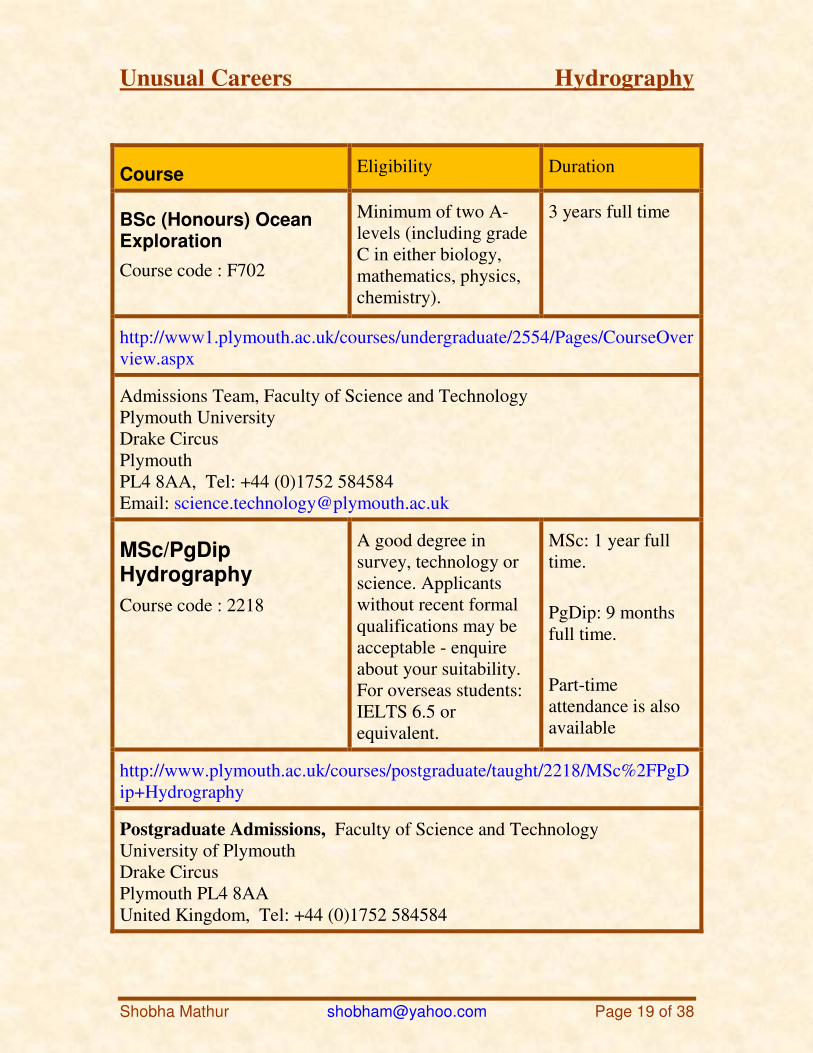
8. University of Plymouth
Faculty of Science and Technology
School of Marine Science and Engineering
Unusual Careers Hydrography
Shobha Mathur [email protected] Page 19 of 38
Course Eligibility Duration
BSc (Honours) Ocean Exploration
Course code : F702
Minimum of two A-levels (including grade C in either biology, mathematics, physics, chemistry).
3 years full time
http://www1.plymouth.ac.uk/courses/undergraduate/2554/Pages/CourseOverview.aspx
Admissions Team, Faculty of Science and Technology Plymouth University Drake Circus Plymouth PL4 8AA, Tel: +44 (0)1752 584584 Email: [email protected]
MSc/PgDip Hydrography
Course code : 2218
A good degree in survey, technology or science. Applicants without recent formal qualifications may be acceptable - enquire about your suitability. For overseas students: IELTS 6.5 or equivalent.
MSc: 1 year full time.
PgDip: 9 months full time.
Part-time attendance is also available
http://www.plymouth.ac.uk/courses/postgraduate/taught/2218/MSc%2FPgDip+Hydrography
Postgraduate Admissions, Faculty of Science and Technology University of Plymouth Drake Circus Plymouth PL4 8AA United Kingdom, Tel: +44 (0)1752 584584
Unusual Careers Hydrography
Shobha Mathur [email protected] Page 20 of 38
Course Details
BSc (Honours) Ocean Exploration
Course code : F702
http://www1.plymouth.ac.uk/courses/undergraduate/2554/Pages/CourseOverview.aspx
The BSc (Honours) Ocean Exploration course covers practical applications of marine science concerned with measurement, determination of position, mapping and visualization of the nature and form of the seabed and its underlying geology
The course studies both the physical characteristics of the world's oceans and investigates the practical techniques used to explore the oceans.
MSc/PgDip Hydrography
http://www.plymouth.ac.uk/courses/postgraduate/taught/2218/MSc%2FPgDip+Hydrography
This programme has been developed in response to expressed commercial need and graduates are sought after throughout the industry. It will provide the foundation for a career in hydrographic research and development, port and offshore/near shore surveying and environmental support. You will develop an understanding of the present state of knowledge relating to Hydrography in the fields of marine geophysics, oceanography, acoustics, geodesy, and marine resource management. You will consider the wider aspects of Hydrography and the implications for data capture, data management, processing, and information systems.
9. Royal New Zealand Navy (RNZN)
RNZN College
Branch Training : Hydrographic School
http://www.navy.mil.nz/visit-the-base/rnzn-college/branch/hydro-school.htm
Unusual Careers Hydrography
Shobha Mathur [email protected] Page 21 of 38
The Hydrographic School conducts a variety of courses, ranging from the Basic Course for new recruits to more senior courses that prepare personnel for their IHO Cat B Certificate Course.
With the way the courses and training are structured, there is potential for a recruit to eventually gain an IHO Cat B Surveyors Qualification or higher (these courses are conducted externally).
The Hydrographic School conducts up to three Basic Hydrographic Survey Courses, a Leading Hydrographic Survey Technician Course and an IHO Cat B Introduction Course every year. These courses vary in length from 8 weeks for the Basic Course to 19 weeks for the LHST course. The IHO Cat B Course is conducted in Australia at HMAS PENGUIN. This course is six months in duration and on successful completion of the course, and a consolidation period, an IHO Cat B Surveyors Qualification is awarded.
10. University of Otago
National School of Surveying
http://www.surveying.otago.ac.nz/study/undergraduate.html
Bachelor of Applied Science (BAppSc, BAppSc(Hons)) majoring in GIS
http://www.otago.ac.nz/courses/qualifications/bsurv.html
The Bachelor of Surveying (BSurv) degree is the only academic qualification available in New Zealand that leads to full professional recognition as a Chartered Surveyor. It is also the only qualification that is recognized as being an appropriate foundation for Licensing by the Cadastral Surveyors Licensing Board of New Zealand.
Otago's BSurv degree is recognized for licensing in all Australian States, in both East and West Malaysia, Singapore, and Hong Kong. It is also recognized as a strong (and appropriate) professional degree for those seeking employment as a surveyor in the United Kingdom, the Middle East, and Africa.
Unusual Careers Hydrography
Shobha Mathur [email protected] Page 22 of 38
The degree is four years in length and aims to produce a graduate skilled in the science of measurement, in the practical issues of land planning and development, and in the legal issues associated with land ownership and resource management. It also allows a student to pursue GIS studies and other specialist professional areas such as hydrographic surveying, photogrammetry, remote sensing, and the study of land tenure systems. The degree is characterized by its strong academic, practical and professional emphasis.
Bachelor of Science (BSc) majoring Surveying
http://www.otago.ac.nz/courses/subjects/surv.html
This three-year degree is comprised of the papers from the measurement science part of the BSurv degree. It is ideal for overseas students who wish to study surveying but not New Zealand land law or land administration. This degree would typically equate with three-year Geomatics degrees offered in places such as the United Kingdom. All applications for admission to this degree must be approved by the Surveying Admissions Committee.
Address
PO Box 56 310 Castle Street Dunedin Tel 64 3 479 7585 Fax 64 3 479 7586 [email protected]
Main Campus
364 Leith Walk Dunedin 9016
PO Box 56 Dunedin, 9054 New Zealand Tel 64 3 479 1100 Fax 64 3 479 8692
Unusual Careers Hydrography
Shobha Mathur [email protected] Page 23 of 38
Information Line 0800 80 80 98 (callers within New Zealand only) Information Line 64 3 479 7000 (callers outside New Zealand) Email [email protected]
11. Universiti Teknologi Malaysia
Course in Hydrography
UTM Hydro I Course (FIG/IHO/ICA Category B) with options Hydrography to Support Port Management and Coastal Engineering, and Inland Waters Hydrography
http://www.fksg.utm.my/course_hydro.php
The Faculty of Geoinformation Science and Engineering, Universiti Teknologi Malaysia (UTM) is the only academic institution in Malaysia and Southeast Asia region presently focusing its effort towards the development of hydrographic surveying.
Medium of Instruction : English.
Course Duration: 24 weeks.
Entry Qualification
At least Certificate or Diploma in Land Surveying/Civil Engineering or other related fields OR
At least two years working experience in the field of land/hydrographic surveying or other related fields.
Address:
Course Director Faculty of Geoinformation Science and Engineering Universiti Teknologi Malaysia 81310 UTM Skudai
Unusual Careers Hydrography
Shobha Mathur [email protected] Page 24 of 38
Johor Darul Takzim MALAYSIA (Attn: Prof. Dr. Mohd Razali Mahmud)
Tel : 607 – 5530827 / 5530803
Fax : 607 – 5566163
Email : [email protected]
Website : www.fksg.utm.my
12. Alfred Wegener Institute
http://www.techawi.org/
TECHAWI, the Training and Education Centre Hydrography at the Alfred Wegener Institute, serves in advanced hydrographic vocational training and education.
TECHAWI offers training for topics such as:
- Swath sonar measurements for waterways and harbors etc. - Sediment survey with echo sounding systems and in-situ verification - Maritime surveillance by hydroacoustic methods - SOLAS offshore security training - UNCLOS screening for an extended juridical Continental Shelf - Marine geophysical processing - Swath data verification, quality control and digital terrain modeling (DTM) - Remotely Operated Vehicle (ROV) training - GIS incl. M-GIS, digital charts and safe navigation - Port management and Integrated Coastal Zone Management (ICZM) - Shallow water hydrography for tsunami studies - Ocean Mapping - The European Water Framework Directive
Concept
TECHAWI offers customized training and lectures in hydrography. The
Unusual Careers Hydrography
Shobha Mathur [email protected] Page 25 of 38
courses vary from a one-day-introduction to hydrography to a course of several days duration in selected topics, e.g. a high-tech training on the job for technical operators.
The curriculum, i.e. topics, complexity, exercises, practical work, and tests, is custom-tailored to the demands of the trainees and the delegating agency, resp.
The education and training at TECHAWI include the following issues:
Hydrographic measurement methods and systems for inland, coasts, and ocean
Training and education with respect to the United Nations Convention on Law of the Sea UNCLOS
Port security (SOLAS), port monitoring and Integrated Coastal Zone Management (ICZM)
Geomorphology and regulations of the European Water Framework Directive
Integration of hydrographic data in GIS for spatial planning and management
Address
TECHAWI - Training and Education Centre Hydrography at AWI e.V. Van-Ronzelen-Str. 2 27568 Bremerhaven Germany Tel : +49 - 471 - 4831 -1223 Fax: +49 - 471 - 4831 -1977 techawi(at)awi.de
13. Northern Alberta Institute of Technology NAIT
Hydrographic Surveying (Get 92)
http://www.nait.ca/course_GET92.asp
Unusual Careers Hydrography
Shobha Mathur [email protected] Page 26 of 38
For certification exam administered by the Canadian Board of Examiners for Professional Surveyors (CBEPS).
Major topics include: • Hydrography, a hydrographic survey, hydrographic charts and the hydrographer; • Nautical/Environmental science in hydrography; meteorology, oceans, rivers, waves, currents and tides; • Terrestrial and marine surveys in inland waters and offshore; • Hydrographic Survey Practice and Standards; • Measurement science; underwater acoustics and acoustic techniques; • Underwater scanning, measuring systems for horizontal and vertical positioning; • Depth determination by echo sounder with its corrections; • Position plotting, navigation and navigation systems; • A brief review of Geodesy as applied to hydrography, map projections, coordinate systems and the UTM.
Prerequisite: Graduation from a Geomatics Engineering Technology Diploma Program or a Bachelor’s Degree from a recognized technical institution. Students should have sound knowledge in the subject matters of map projections, geodesy, coordinate systems, and geo-informatics. Students with demonstrated extensive work experience in geomatics engineering would be considered. Please Note:
This course has two different delivery options,
Either in class or by distance via Video conference. Hours: 69.00
Address
The Northern Alberta Institute of Technology
11762 - 106 Street Edmonton, Alberta, Canada, T5G 2R1
Phone: 780-471-NAIT (780-471-6248) Toll Free: 1-877-333-NAIT (1-877-333-6248) Fax: 780-471-8490
Email: [email protected]
Unusual Careers Hydrography
Shobha Mathur [email protected] Page 27 of 38
Tech Support: [email protected]
14. The University of New Hampshire
Center for Coastal and Ocean Mapping
http://www.ccom-jhc.unh.edu/index.php?page=education.php
One of the major goals of the NOAA/UNH Joint Hydrographic Center - UNH Center for Coastal and Ocean Mapping is to maintain an internationally recognized education and training program in the hydrographic and ocean mapping sciences.
The University of New Hampshire offers Ocean Mapping options on the Master of Science and Doctor of Philosophy degrees in Ocean Engineering and in Natural Resources and Earth Systems Science (NRESS). These interdisciplinary degree programs are provided through the Center and the respective academic departments of the College of Engineering and Physical Sciences. The University has been awarded recognition as a Category a hydrographic education program by the International Federation of Surveyors (FIG)/International Hydrographic Organization (IHO).
The long-term goal of the educational program is to establish degree and certification programs at both the graduate and undergraduate level and continuing education programs for hydrographic professionals. We have chosen an evolutionary path toward this goal with our initial focus on graduate degree programs.
Specific Programs Offered:
• MS Ocean Engineering (Ocean Mapping Option) • MS Earth Sciences (Ocean Mapping Option) • Graduate Certificate Program • FIG/IHO Category A Certification
Address:
Center for Coastal & Ocean Mapping Joint Hydrographic Center
Unusual Careers Hydrography
Shobha Mathur [email protected] Page 28 of 38
Jere A. Chase Ocean Engineering Lab
24 Colovos Road
Durham, New Hampshire 03824 USA
Phone: (603) 862-3438
Fax: (603) 862-0839
lat/lon: 43.136958; -70.937392
Linda Prescott (Senior Program Support Assistant)
Email: [email protected]
http://www.ccom.unh.edu/
15. Hydro Geo
http://hydrogeo.org/id71.html
It is a new entrant, the course page has several listings, but they
were not going any further on 13 aug. 2011. You may try later
with better luck.
The Hydrography and Geomatics Organization is a non-governmental scientific, technical and consultative organization that was established in 2011 to support the education, research, association, GIS & database banking, consultancy services, Operation & recruitment consultancy, safety and protection of the environment.
Address
No.5, 3rd Floor,
Flat No. 14, Bahonar St, Resalat Bridge,
Ashrafi Isfahani Blv, Tehran, Iran
Zip Code:1473684181
Unusual Careers Hydrography
Shobha Mathur [email protected] Page 29 of 38
Phone: +98-21-44015916
Fax: +98-21-44014453
Email: [email protected]
16. Maritime Institute Willem Barentsz
http://www.miwb.nl/index.php?db=4&maincat=opleidingen&cat=opleidingen&menu=Hydrography
Maritime Institute Willem Barentsz is ideally situated to start your training as a marine cartographer. In 2002 the higher vocational hydrography course moved from Amsterdam to Terschelling.
With the Dutch dredging industry, survey agencies and the Department of Waterworks highly qualified hydrographic engineers are in great demand. So if you like to work hard and love to explore the world’s bathysphere, but are not all that keen on life aboard a merchant vessel or in a nine-to-five office job, a hydrography course could be grist to your mill.
Address
NOORDELIJKE HOGESCHOOL LEEUWARDEN Postadres NHL Hogeschool Postbus 1080 8900 CB Leeuwarden NHL Hogeschool Rengerslaan 10 8917 DD Leeuwarden Tel.: 058 – 251 2345 Fax: 058 – 251 1950
MIWB
Tel.: 0562-44 6600 Fax: 0562-44 6601 E-mail: [email protected]
Unusual Careers Hydrography
Shobha Mathur [email protected] Page 30 of 38
17. Canadian Hydrographic Service
Training
http://www.canfoh.org/Training/training1.htm
The Training Files include the following training programs:
Hydrography I Course 1953 - 1987
A training course for all field hydrographers upon entering the CHS.
Hydrography II Course 1968 -.
A course given after a few years of field experience and required to be promoted beyond the ESS6 Level.
Cartography I Course,
Cartography II Course,
University Training Plan
Basic Charting Course-1989
Hydrographer-in-Charge Seminar 1985
Senior Cartographers Seminar-1989
Canada Lands Surveyor Commission,
"Hydrography" Course - 1988 -
A course for both field hydrographers and cartographers to bring them to equal proficiency. This allowed them all to be classified as EGs. Included are modules of Hydrography, Cartography and Seamanship and Navigation. (Note: Documentation for execution of these courses is not available at this time.)
Supplemental Training
Training conducted by Staff Training - In Canada, outside the CHS - Foreign training, outside of Canada
Email : [email protected]
Unusual Careers Hydrography
Shobha Mathur [email protected] Page 31 of 38
18. MosaicHydro
http://www.mosaichydro.com/training.html
Do you have employees that need new training or refresher training? Let MosaicHydro help. We teach hydrographic training courses designed for the individuals operating the equipment rather than the engineers who designed it. Our approach to all of our courses is first to teach the essential theory behind the technology, focusing on the practical applications of each concept covered. Next we move into the teaching how to use the technology in a thorough and easy-to-understand teaching method. Finally, where possible, we bring together all aspects of the lectures with practical at-sea training. Your employees will leave our course competent and confident on how to operate the equipment they learned about during the course.
Our courses include:
3 & 5 Day Sidescan Sonar Training Courses
3 & 5 Day Multibeam Sonar Training Courses
10 Day Hydrographic Training Course
Hydrographic Software Training Courses
Custom Designed Courses
Address
Mosaic Hydrographic Services
2239 Meadowvale drive
Victoria BC
Canada V98 6J2
Ph (250) 727 7853
Unusual Careers Hydrography
Shobha Mathur [email protected] Page 32 of 38
19. Specialist Certification in Hydrographic Surveying
http://www.surveyors.org.nz/node/76087
Specialist Certification in Hydrographic Surveying is the official recognition by the New Zealand Institute of Surveyors (NZIS) and the Surveying and Spatial Sciences Institute (SSSI
The Australasian Hydrographic Surveyors' Certification Panel
(AHSCP) is structured within the SSSI Hydrography Commission and is sponsored by, and comprises members of, the SSSI and the NZIS.
The AHSCP assesses applications for Specialist Certification in Hydrographic Surveying and informs both bodies of its decisions. The AHSCP uses the latest edition of the International Hydrographic Organization (IHO) document M-5 Standards of Competence for
Hydrographic Surveyors as its reference for assessment of competence. This document can be accessed on the IHO website (http://www.iho-ohi.net/english/home/)
Certification requires that an extensive portfolio of experience be demonstrated. In order to maintain certification once obtained, currency must be maintained by demonstrating ongoing Continued Professional Development (CPD).
A DVD entitled The Certification of Hydrographic Surveyors in
Australasia – Offshore Construction Hydrography is available. Contact the Secretary (details below) for a copy or you can view it on Youtube by following these links: Part 1
Part 2
Please send completed applications to the AHSCP Secretary -
AHSCP Secretary (Jasbir Randhawa)
Australian Hydrographic Office
8 Station Street
Unusual Careers Hydrography
Shobha Mathur [email protected] Page 33 of 38
WOLLONGONG
NSW 2500
Tel: +61 (02) 4221 8672
Fax: +61 (02) 4221 8599
Email: [email protected]
Miscellaneous Related Information
4. International Hydrographic Organization ( IHO),
The basic information is taken from this site and its publications.
Special Publication S-47 : This publication lists international institutes. You can download a free copy from the site
http://www.iho.int/iho_pubs/IHO_Download.htm
TRAINING COURSES IN HYDROGRAPHY AND NAUTICAL CARTOGRAPHY
7th edition, updated April2011.
Published by the International Hydrographic Bureau
4 quai Antoine Ier
B.P. 445 - MC 98011 MONACO Cedex
Principauté de Monaco
Telefax: (377) 93.10.81.40
E-mail: [email protected]
Web: www.iho.int

Unusual Careers Hydrography
Shobha Mathur [email protected] Page 34 of 38
Standardization
For over 80 years the International Hydrography Organization (IHO) has set the bench mark for al nautical practices. All the training, survey practices, and services are of consistent international standard.
Hence the same syllabus is taught in all countries.
IHO publication S-4 and S-52 are guidelines of IHO standard for the adoption of consistent colors, symbols, nomenclature and general presentation for charts produced by IHO Member Organization. This makes it possible to produce charts that can be understood universally.
In cooperation with the Fédération Internationale des Géomètres (FIG), and the International Cartographic Association (ICA), a comprehensive set of Standards of Competence for hydrographic surveyors and nautical cartographers have been drawn up, together with appropriate syllabi for the guidance of universities and teaching establishments throughout the world.
An International Advisory Board supervises the application of these standards with a view to achieving internationally recognized qualifications in the hydrographic profession. The Advisory Board reviews the training syllabi of worldwide educational institutions, and awards international certificates of recognition to those courses which have achieved the required minimum standards of competence.
Three important publications relating to education and training include: ( As on Aug. 2011)
• IHO Publication S-5: "Standards of Competence for Hydrographic Surveyors";
• IHO Publication S-8: "Standards of Competence for Nautical Cartographers";
• IHO Publication C-47: "Courses in Hydrography and Nautical Cartography".

Unusual Careers Hydrography
Shobha Mathur [email protected] Page 35 of 38
These and other related publications can be downloaded free from the IHO site :
http:/www.iho-ohi.net/iho_pubs/IHO_Download.htm
5. NATIONAL INSTITUTE OF HYDROGRAPHY
Brief History
The first Systematic training of Officers and Sailors in Hydrography began with the establishment of a Hydrographic Training Unit at Bombay in 1959 which shifted to Cochin on October 21, 1961.
The Hydrographic School at Goa was formally inaugurated on November 29, 1978.
In 1980, the Hydrographic School was accorded the status of Regional Training Centre in Hydrographic Survey for South Asian Region.
In 1984, the Hydrographic School was recognized as the Regional Hydrographic Training Centre for Southeast Asian and African countries.
In 1997, the Hydrographic School was awarded the Cat 'A' Certification by IHO.
The School was consequently re-designated as the National Hydrographic School. As it did provide training to Hydrographers from other National Maritime Organizations such as the Minor Port Survey Organizations, Port Trusts, Dredging Corporation of India, Inland Water ways Authority of India besides the naval fraternity of Hydrographers from both within India and from abroad.
The school was rechristened as 'NATIONAL INSTITUTE OF HYDROGRAPHY' on 05 Jun 2009.
On the net the addresses are still available for both names.
Unusual Careers Hydrography
Shobha Mathur [email protected] Page 36 of 38
• The institute is acknowledged as the Regional Training Centre for Hydrography for S-E Asia and Africa and has all the requisite accreditations and affiliations for training in Hydrography viz:-
• IHO Cat A certification for Long Hydrographic Course
• IHO Cat B certification for Basic Hydrographic Course
• Affiliation to Goa University for award of M.Sc in Hydrography on successful completion of Long Hydrographic Course
• Affiliation to Cochin University of Science and Technology for award of Diploma in Hydrography on successful completion of PO 'Q' Course
6. International Federation of Hydrographic Societies
http://www.hydrographicsociety.org/
The International Federation of Hydrographic Societies (IFHS) is a unique partnership of learned national and regional hydrographic societies that, through its worldwide membership, is able to address every specialism within the hydrographic profession and related disciplines, at all levels of experience and expertise. It has considerable international influence, and is respected by hydrographic professionals and organizations at governmental and intergovernmental level.
The Federation is recognized throughout the world for promoting the development of hydrography and hydrographic learning by providing unrivalled opportunities for the exchange of ideas and practices.
7. Hydro International
http://www.hydro-international.com/magazineprofile.php
Hydro International started out as a print magazine in 1996 and soon developed into a the multimedia platform it is today, featuring a successful website (http://www.hydro-international.com) and respected weekly e-newsletter.

Unusual Careers Hydrography
Shobha Mathur [email protected] Page 37 of 38
Hydro International magazine is published six times a year. The magazine is international in scope and focuses on bringing to its readership topical overviews and the latest news and developments in the technology and management of hydrographic activities.
8. The Surveying & Spatial Sciences Institute (SSSI)
http://www.sssi.org.au/index.php?option=com_content&task=view&id=204&Itemid=177
The Surveying & Spatial Sciences Institute (SSSI) is Australia and New Zealand's peak body representing the interests of surveying and spatial science professionals, combining the disciplines of land surveying, engineering & mining surveying, cartography, hydrography, remote sensing and spatial information science.
9. Canadian Hydrographic Association
http://www.hydrography.ca/home.html
The Canadian Hydrographic Association (CHA) is a non-profit, scientific and technical group of more than 200 members with the objective of:
• advancing the development of hydrography, marine cartography and associated activities in Canada;
• furthering the knowledge and professional development of its members;
• enhancing and demonstrating the public need for hydrography;
• assisting in the development of hydrographic sciences in developing countries.
It is the only national hydrographic organization in Canada. It embraces the disciplines of:
• hydrographic surveying;
• marine cartography;
• marine geodesy;
• offshore exploration;
Unusual Careers Hydrography
Shobha Mathur [email protected] Page 38 of 38
• tidal and tidal current studies.
The Canadian Hydrographic Association is formally affiliated with the Canadian Institute of Geomatics. It is informally associated with The Hydrographic Society of America (THSOA).
Membership
Membership is open to all hydrographers, those working in associated disciplines, and those interested in hydrography and marine cartography.
10. Hydrographic Standards & Technical Specifications
This page sets out the hydrographic standards and specifications that LINZ contractors must comply with when producing nautical charts and publications.
http://www.linz.govt.nz/hydro/regulation
11. The Hydrographic Society UK
This page lists a range of academic and commercial courses and training programmes in hydrographic surveying and associated disciplines.
http://www.ths.org.uk/courses.asp