Embed Size (px)
Citation preview

EGNOS IN LAND APPLICATIONS MARKET UPDATE
EGNOS Service Provision Workshop 2015
Copenhagen, 30th September 2015
Carmen Aguilera
Market Development Department
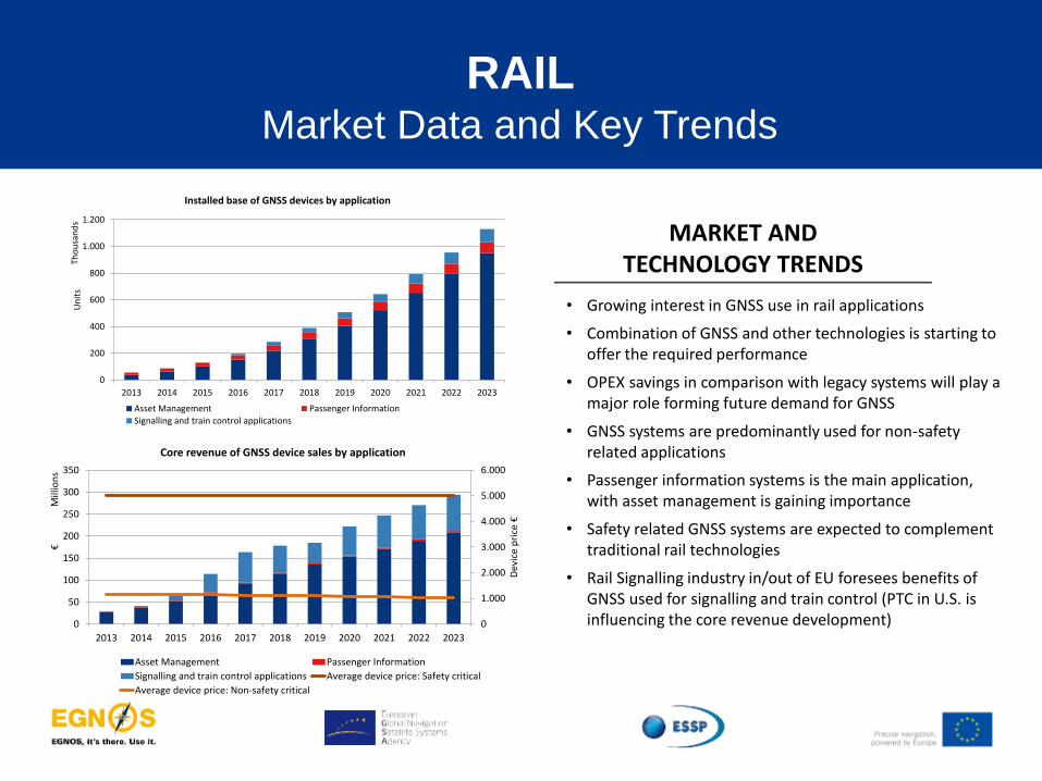
RAIL Market Data and Key Trends
MARKET AND TECHNOLOGY TRENDS
• Growing interest in GNSS use in rail applications
• Combination of GNSS and other technologies is starting to offer the required performance
• OPEX savings in comparison with legacy systems will play a major role forming future demand for GNSS
• GNSS systems are predominantly used for non-safety related applications
• Passenger information systems is the main application, with asset management is gaining importance
• Safety related GNSS systems are expected to complement traditional rail technologies
• Rail Signalling industry in/out of EU foresees benefits of GNSS used for signalling and train control (PTC in U.S. is influencing the core revenue development) 0
1.000
2.000
3.000
4.000
5.000
6.000
0
50
100
150
200
250
300
350
2013 2014 2015 2016 2017 2018 2019 2020 2021 2022 2023
Dev
ice
pri
ce €
€M
illio
ns
Core revenue of GNSS device sales by application
Asset Management Passenger Information
Signalling and train control applications Average device price: Safety critical
Average device price: Non-safety critical
0
200
400
600
800
1.000
1.200
2013 2014 2015 2016 2017 2018 2019 2020 2021 2022 2023
Un
its
Tho
usa
nd
s
Installed base of GNSS devices by application
Asset Management Passenger Information
Signalling and train control applications

RAIL Map of possible applications
Signalling Logistics
Low density lines
Combination of E-GNSS with sensors for precise train positioning for use in safety of life CCS applications or with conventional communication technologies for logistics applications.
Main lines
Improve safety and reduce the cost of signalling (requires very few or no line side components).
Reduce the number of physical balises and to improve the precision of the odometry.
Improve availability of the supply chain visibility information to the LSP/LSC. - Georeferenced cargo
status monitoring - Corridoring,
Geofencing
Asset management Improve monitoring of the railway assets both for operators and IM´s.
Cargo monitoring
Passenger information systems
Improve precision and availability of positioning for on board PIS

Continued support to develop E-GNSS applications in Rail through H2020
4
4
• Enable dedicated E-GNSS performance tests in frame of R&D supporting railway stakeholders to prove the operational performance
• Support UNISIG and Next Generation Train Control project in their effort to define virtual balise and performance requirements
• Foster implementation of technical solution into ERTMS specifications
For non safety relevant applications:
• Support the establishment of standardised, E-GNSS enabled asset and cargo tracking solutions for positioning of rail as a key player in the future European multimodal transport
ERSAT project will leverage the achievements of FP7 and help to ensure inclusion of E-GNSS into future evolutions of ERTMS
MARKET AND TECHNOLOGY TRENDS
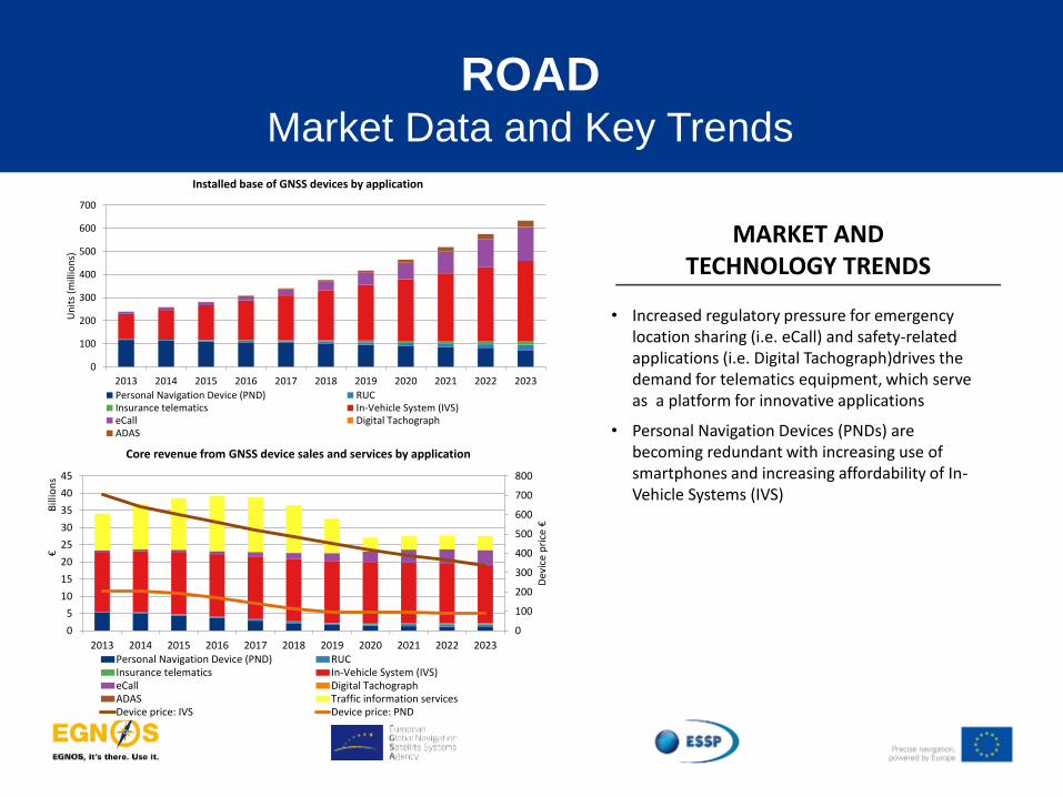
• Increased regulatory pressure for emergency location sharing (i.e. eCall) and safety-related applications (i.e. Digital Tachograph)drives the demand for telematics equipment, which serve as a platform for innovative applications
• Personal Navigation Devices (PNDs) are becoming redundant with increasing use of smartphones and increasing affordability of In-Vehicle Systems (IVS)
0
100
200
300
400
500
600
700
800
0
5
10
15
20
25
30
35
40
45
2013 2014 2015 2016 2017 2018 2019 2020 2021 2022 2023
Dev
ice
pri
ce €
€B
illio
ns
Core revenue from GNSS device sales and services by application
Personal Navigation Device (PND) RUCInsurance telematics In-Vehicle System (IVS)eCall Digital TachographADAS Traffic information servicesDevice price: IVS Device price: PND
0
100
200
300
400
500
600
700
2013 2014 2015 2016 2017 2018 2019 2020 2021 2022 2023
Un
its
(mill
ion
s)
Installed base of GNSS devices by application
Personal Navigation Device (PND) RUCInsurance telematics In-Vehicle System (IVS)eCall Digital TachographADAS
ROAD Market Data and Key Trends

eCall system will send an emergency call to 112 in case of
accident, including precise location, accelerating assistance to drivers
Road User Charging GNSS supports toll operators in charging levies in compliance with the European Electronic Tolling System Directive
Digital tachographs will facilitate registration of starting-ending time of the journey
Dangerous goods tracking: robust positioning requirements uptake in EU Member States
Regulations in Europe are accelerating the business case for EGNOS in road applications

makes the difference!
Road Tolling eCall
During the last months, Road Tolling and eCall applications have demonstrated interest on
EGNOS value added

makes the difference!
Road Tolling eCall
During the last months, Road Tolling and eCall applications have demonstrated interest on
EGNOS value added
EGNOS in all cars from April 2018
13,000.000 cars/year
EGNOS in Slovakia
and Germany
AGRICULTURE Market Data and Key Trends
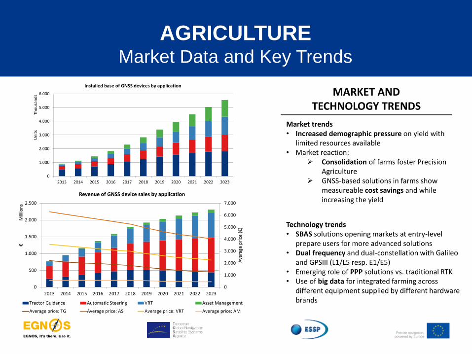
Market trends • Increased demographic pressure on yield with
limited resources available • Market reaction:
Consolidation of farms foster Precision Agriculture
GNSS-based solutions in farms show measureable cost savings and while increasing the yield
MARKET AND TECHNOLOGY TRENDS
Technology trends • SBAS solutions opening markets at entry-level
prepare users for more advanced solutions • Dual frequency and dual-constellation with Galileo
and GPSIII (L1/L5 resp. E1/E5) • Emerging role of PPP solutions vs. traditional RTK • Use of big data for integrated farming across
different equipment supplied by different hardware brands
0
1.000
2.000
3.000
4.000
5.000
6.000
7.000
0
500
1.000
1.500
2.000
2.500
2013 2014 2015 2016 2017 2018 2019 2020 2021 2022 2023
Ave
rage
pri
ce (
€)
€M
illio
ns
Revenue of GNSS device sales by application
Tractor Guidance Automatic Steering VRT Asset Management
Average price: TG Average price: AS Average price: VRT Average price: AM
0
1.000
2.000
3.000
4.000
5.000
6.000
2013 2014 2015 2016 2017 2018 2019 2020 2021 2022 2023
Un
its
Tho
usa
nd
s
Installed base of GNSS devices by application
Tractor Guidance Automatic Steering VRT Asset Management

AGRICULTURE Map of possible applications
• Use of a digital display assisting drivers to follow a predetermined path, minimizing risks of overlap/gap
Application Description Target Users Value Proposition
Machine Guidance
Automatic Steering
• The most advanced form of tractor guidance, used mainly on large farms, allowing farm vehicles to be automatically steered along a predetermined path
• The operator can concentrate solely on monitoring the overall process
VRT (Variable Rate Technology)
• Leverages local conditions on the field for precise control over farming inputs (e.g. fertilizers, nutrients)
• It identifies areas with similar levels of yield-limiting characteristics in a field and enables site-specific treatment
Asset Management • Involves the use of real time information
for monitoring the location and status of farm equipment
• High accuracy (close to 0,1m) : Galileo CS
• Medium accuracy OS dual Frequency (< 1m)
• Basic accuracy: EGNOS (basic accuracy for low cost, entry level
• Galileo Authentication (Potential upside tbc)
• Farmers
• Public authorities
New potential applications
• Harvest monitoring; Biomass monitoring; Soil sampling; Land consolidation; Livestock monitoring; Virtual fencing; Geo-traceability; Environmental Mgmt

MARKET AND TECHNOLOGY TRENDS
0
500
1.000
1.500
2.000
2.500
2013 2014 2015 2016 2017 2018 2019 2020 2021 2022 2023
Un
its
Tho
usa
nd
s
Installed base of GNSS devices by application
Cadastral Construction - Machine control Construction - Person basedMapping Mining Marine Surveying
Market trends and drivers • Regulatory requirements remain in “traditional”
surveying applications such as cadastral surveying • Strong dependence on general economic situation
(mainly impacting construction surveying) driven by emerging countries
• New customers “insourcing” surveying operations (e.g., municipalities, utility companies) to map infrastructure and networks
Technology trends • Continued use in conjunction with other surveying
technologies (e.g. laser scanning, LIDAR) • Emerging role of PPP solutions vs. traditional RTK • Dual frequency and multi-constellation expected
by Galileo and GPSIII (L1/L5 resp. E1/E5) • Increased use of entry-level equipment by non-
surveyors • Crowd-sourcing for mapping applications
SURVEYING & MAPPING
Market Data and Key Trends
0
2.000
4.000
6.000
8.000
10.000
12.000
14.000
0
1.000
2.000
3.000
4.000
5.000
6.000
2013 2014 2015 2016 2017 2018 2019 2020 2021 2022 2023
Dev
ice
pri
ce €
€M
illio
ns
Core revenue from GNSS device sales and service by application
Cadastral Construction - Machine controlConstruction - Person based MappingMining Marine Surveying

SURVEYING & MAPPING
Map of key possible applications
• Physical delineation of property boundaries in parcels and the determination of dimensions, areas and certain rights associated with properties
Application Description Target Users Value Proposition
Cadastral surveying
Mine surveying
• Measurements, calculations and mapping with the purpose of ascertaining and documenting information at all stages from prospecting to exploitation and utilizing mineral deposits
Construction surveying
• Precise drawing of the future work site for buildings and infrastructures; taking out of reference points that will guide the construction of new structures
Mapping
• Plot maps and charts that contain locations of point of interest (roads, pipelines, planning of public works, forestry management, etc.)
• High accuracy (close to 0,1m), continuity and resistance against multipath: Galileo CS (HP surveying)
• Reliability with Authentication (TBC): Galileo CS
• Basic accuracy/ low cost for mapping:
EGNOS
Galileo OS Dual Frequency
• Public and private surveyors
• Construction companies, marine operators
• O&G Exploration and Production Offshore players
• Small/Medium sized municipalities (for Mapping) Marine surveying
• Measurement and description of features which affect maritime navigation, marine construction, dredging, offshore oil exploration, etc.
CAP Field Boundary measurement
• Common Agriculture Policy uses GNSS for on-the-spot checks performed by paying agencies to verify subsidy claims
12

THANK YOU FOR YOUR ATTENTION
Carmen Aguilera
Aviation and R&D Market Development Officer, GSA
www.gsa.europa.eu