Embed Size (px)
Citation preview

Ecology Assessment Report 46BWR274
Doc Ref: Q-4550-15-RP-001_34 Revision: 0 Page 2 of 61
Approvals, Land and Stakeholder Team, Australia Pacific LNG Upstream Phase 1
Uncontrolled when printed unless issued and stamped Controlled Copy.
Release Notice This document is available through the Australia Pacific LNG Pty Limited (Australia Pacific LNG) Upstream Phase 1 Project controlled document system TeamBinder™. The responsibility for ensuring that printed copies remain valid rests with the user. Once printed, this is an uncontrolled document unless issued and stamped Controlled Copy.
Third-party issue can be requested via the Australia Pacific LNG Upstream Phase 1 Project Document Control Group.
Document Conventions The following terms in this document apply:
• Will, shall or must indicate a mandatory course of action
• Should indicates a recommended course of action
• May or can indicate a possible course of action.
Document Custodian The custodian of this document is the Australia Pacific LNG Upstream Phase 1 Project – Environmental Approvals Manager. The custodian is responsible for maintaining and controlling changes (additions and modifications) to this document and ensuring the stakeholders validate any changes made to this document.
Deviations from Document Any deviation from this document must be approved by the Australia Pacific LNG Upstream Phase 1 Project – Environmental Approvals Manager.

Ecology Assessment Report 46BWR274
Doc Ref: Q-4550-15-RP-001_34 Revision: 0 Page 3 of 61
Approvals, Land and Stakeholder Team, Australia Pacific LNG Upstream Phase 1
Uncontrolled when printed unless issued and stamped Controlled Copy.
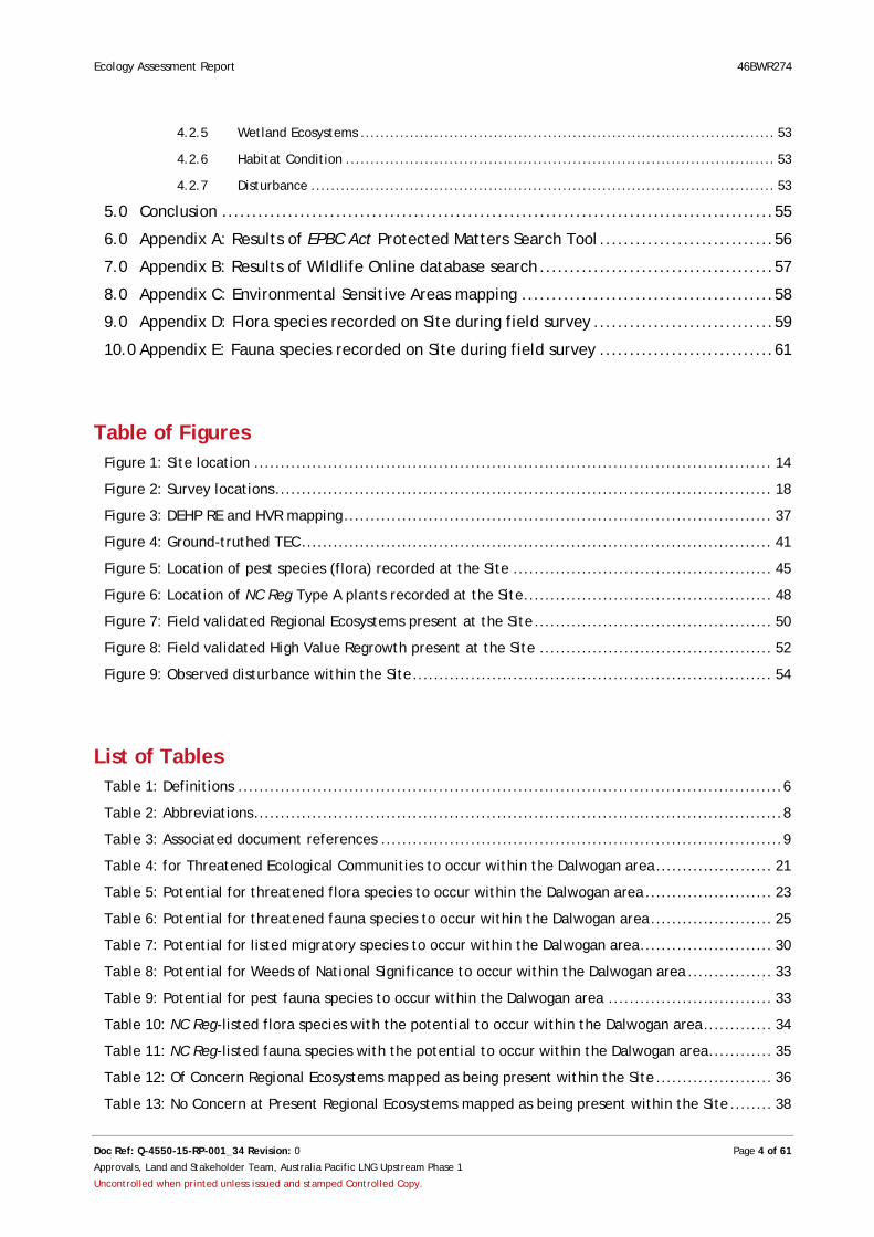
Table of Contents 1.0 Definitions & Abbreviations ......................................................................... 6
1.1 Definitions .................................................................................................. 6
1.2 Abbreviations ............................................................................................... 8
1.3 Document References ..................................................................................... 9
2.0 Introduction .......................................................................................... 13
2.1 Scope of Work ............................................................................................ 13
2.2 Site Context .............................................................................................. 15
2.3 Location ................................................................................................... 15
2.4 Bioregion .................................................................................................. 16
2.5 Current Land Use ........................................................................................ 16
2.6 Soils and Geology ........................................................................................ 16
2.7 Climate .................................................................................................... 16
3.0 Methodology .......................................................................................... 17
3.1 Desktop and Literature Review ....................................................................... 17
3.2 Field Survey ............................................................................................... 17
3.2.1 Site Selection ............................................................................................ 17
3.2.2 Vegetation Community Survey ........................................................................ 19
3.2.3 Habitat Survey ........................................................................................... 19
3.2.4 Threatened Flora and Fauna Survey .................................................................. 20
3.2.5 Exotic Flora and Fauna Survey ........................................................................ 20
3.2.6 Disturbance Survey...................................................................................... 20
3.2.7 Survey Limitations ...................................................................................... 20
4.0 Results and Discussion .............................................................................. 21
4.1 Desktop and Literature Review ....................................................................... 21
4.1.1 Matters of National Environmental Significance .................................................... 21
4.1.2 Wetland of International Importance ................................................................ 33
4.1.3 Nature Conservation Act ............................................................................... 33
4.1.4 Environmentally Sensitive Areas ...................................................................... 36
4.1.5 Referable Wetlands ..................................................................................... 36
4.1.6 Regional Ecosystems .................................................................................... 36
4.2 Field Survey ............................................................................................... 39
4.2.1 Matters of National Environmental Significance .................................................... 39
4.2.2 Nature Conservation Act ............................................................................... 46
4.2.3 Environmentally Sensitive Areas ...................................................................... 49
4.2.4 Other Environmental Values (DEHP Mapping) ....................................................... 51
Ecology Assessment Report 46BWR274
Doc Ref: Q-4550-15-RP-001_34 Revision: 0 Page 4 of 61
Approvals, Land and Stakeholder Team, Australia Pacific LNG Upstream Phase 1
Uncontrolled when printed unless issued and stamped Controlled Copy.
4.2.5 Wetland Ecosystems .................................................................................... 53
4.2.6 Habitat Condition ....................................................................................... 53
4.2.7 Disturbance .............................................................................................. 53
5.0 Conclusion ............................................................................................ 55
6.0 Appendix A: Results of EPBC Act Protected Matters Search Tool ............................. 56
7.0 Appendix B: Results of Wildlife Online database search ....................................... 57
8.0 Appendix C: Environmental Sensitive Areas mapping .......................................... 58
9.0 Appendix D: Flora species recorded on Site during field survey .............................. 59
10.0 Appendix E: Fauna species recorded on Site during field survey ............................. 61
Table of Figures Figure 1: Site location .................................................................................................. 14
Figure 2: Survey locations .............................................................................................. 18
Figure 3: DEHP RE and HVR mapping ................................................................................. 37
Figure 4: Ground-truthed TEC ......................................................................................... 41
Figure 5: Location of pest species (flora) recorded at the Site ................................................. 45
Figure 6: Location of NC Reg Type A plants recorded at the Site ............................................... 48
Figure 7: Field validated Regional Ecosystems present at the Site ............................................. 50
Figure 8: Field validated High Value Regrowth present at the Site ............................................ 52
Figure 9: Observed disturbance within the Site .................................................................... 54
List of Tables Table 1: Definitions ....................................................................................................... 6
Table 2: Abbreviations .................................................................................................... 8
Table 3: Associated document references ............................................................................ 9
Table 4: for Threatened Ecological Communities to occur within the Dalwogan area ...................... 21
Table 5: Potential for threatened flora species to occur within the Dalwogan area ........................ 23
Table 6: Potential for threatened fauna species to occur within the Dalwogan area ....................... 25
Table 7: Potential for listed migratory species to occur within the Dalwogan area ......................... 30
Table 8: Potential for Weeds of National Significance to occur within the Dalwogan area ................ 33
Table 9: Potential for pest fauna species to occur within the Dalwogan area ............................... 33
Table 10: NC Reg-listed flora species with the potential to occur within the Dalwogan area ............. 34
Table 11: NC Reg-listed fauna species with the potential to occur within the Dalwogan area ............ 35
Table 12: Of Concern Regional Ecosystems mapped as being present within the Site ...................... 36
Table 13: No Concern at Present Regional Ecosystems mapped as being present within the Site ........ 38

Ecology Assessment Report 46BWR274
Doc Ref: Q-4550-15-RP-001_34 Revision: 0 Page 5 of 61
Approvals, Land and Stakeholder Team, Australia Pacific LNG Upstream Phase 1
Uncontrolled when printed unless issued and stamped Controlled Copy.
Table 14: HVR mapped as being present within the Site ......................................................... 39
Table 15: EPBC Act-protected flora species with potential to occur within the Site ....................... 40
Table 16: EPBC Act-protected fauna species with potential to occur within the Site ...................... 42
Table 17: EPBC Act-protected Migratory Fauna species with potential to occur within the Site ......... 43
Table 18: Weed species identified as being present within the Site ........................................... 44
Table 19: Pest animal species identified or likely to be present within the Site ............................ 44
Table 20: NC Reg-listed flora with potential to occur within the Site as identified from the field survey .............................................................................................................................. 46
Table 21: NC Reg-listed fauna with potential to occur within the Site as identified from field survey . 47
Table 22: No Concern at Present Regional Ecosystems identified as being present within the Site ...... 51
Table 23: HVR identified as being present within the Site ....................................................... 51

Ecology Assessment Report 46BWR274
Doc Ref: Q-4550-15-RP-001_34 Revision: 0 Page 6 of 61
Approvals, Land and Stakeholder Team, Australia Pacific LNG Upstream Phase 1
Uncontrolled when printed unless issued and stamped Controlled Copy.
1.0 Definitions & Abbreviations
1.1 Definitions Table 1: Definitions
Term Definition
Biocondition Biocondition is a condition assessment framework for Queensland that provides a measure of how well a terrestrial ecosystem is functioning for the maintenance of biodiversity values at a local or property scale. It is a Site-based, quantitative and repeatable assessment that provides a numeric score that can be summarised as a condition rating of 1, 2, 3 or 4, or functional through to dysfunctional condition for biodiversity. Condition is measured as the degree to which the attributes of a patch of vegetation differs from the attributes of the same vegetation in its reference state.
Biodiversity Status (Remnant vegetation)
The biodiversity status of remnant vegetation is based on an assessment of the condition of remnant vegetation in addition to the criteria used to determine the class under the Vegetation Management Act 1999 (VM Act). The biodiversity status is used for a range of planning and management applications including the determination of Environmentally Sensitive Areas (ESA) that are used for regulation in the mining industry through provisions of the Environmental Protection Act 1994 (EP Act).
Bioregion Bioregions are geographically distinct areas with common characteristics such as geology, landform patterns, climate and ecological features. Queensland is divided into 13 bioregions.
Class 2 Pest Pest that is established in Queensland, and has, or could have, a substantial adverse economic, environmental or social impact
Coal Seam Gas Coal Seam Gas (CSG) is a form of natural gas extracted from underground coal seams. The term refers to methane absorbed into the solid matrix of the coal.
Coal Seam Gas Seismic Survey
Seismic surveys produce a detailed image of the geology beneath the earth’s surface, by bouncing sound waves off underground rock formations. This information can be used to accurately plan the location of CSG wells. Seismic surveying on land usually consists of a series of linked seismic lines.
Environmentally Sensitive Area
Environmentally Sensitive Areas (ESAs) are locations that have environmental values that contribute to maintaining biological diversity and integrity; have intrinsic or attributed scientific, historical, or cultural heritage value; or are important in providing amenity harmony or sense of community. ESAs are broken down into three categories: A, B or C.
Category A areas are those that have significant ecological values, such as national parks or marine parks. Category B areas have ecological values such as regional ecosystems (REs) with an endangered biodiversity status or Ramsar wetlands. Category C areas typically include ecological values such as REs with an Of Concern biodiversity status, essential habitat or referable wetlands.
For the purposes of ESAs, the biodiversity status of the RE is considered, not the status under the Vegetation Management Act 1999 (VM Act).
Essential Habitat Vegetation in which a species that is endangered, vulnerable, or near threatened under the Nature Conservation Act 1992 (NC Act) has been known to occur, and has been mapped as essential habitat by the Department of Environment and Heritage Protection (DEHP).
High Value Regrowth High Value Regrowth (HVR) vegetation is mature native vegetation that: has not been cleared since 31 December 1989; is an Endangered, Of Concern or Least Concern regional ecosystem; and is shown on a regrowth vegetation map.
Ecology Assessment Report 46BWR274
Doc Ref: Q-4550-15-RP-001_34 Revision: 0 Page 7 of 61
Approvals, Land and Stakeholder Team, Australia Pacific LNG Upstream Phase 1
Uncontrolled when printed unless issued and stamped Controlled Copy.
Term Definition
Regional Ecosystems Defined by Sattler and Williams (1999) as vegetation communities in a bioregion that are consistently associated with a particular combination of geology, landform and soil.
Referable Wetland An area identified as a wetland on the DEHP Map of Referable Wetlands.
Remnant Vegetation Vegetation that has not been cleared or vegetation that has been cleared but where the dominant canopy has >70% of the height and >50% of the cover relative to the undisturbed height and cover of that stratum and is dominated by species characteristic of the vegetation's undisturbed canopy.
Site Lot 46 on BWR274.
Dalwogan Area Dalwogan 3D Seismic Area.
Type A restricted plant Type A restricted plants are orchids, epiphytic ferns, cycads, grass trees and other popular horticultural species that may not be considered sufficiently rare to be classified as threatened, but are harvested and traded to the extent that a threat to the species might exist. To ensure populations of these plants are not depleted to the point that they become threatened trade is controlled, as is all taking in the wild for commercial or recreational purpose.
Ecology Assessment Report 46BWR274
Doc Ref: Q-4550-15-RP-001_34 Revision: 0 Page 8 of 61
Approvals, Land and Stakeholder Team, Australia Pacific LNG Upstream Phase 1
Uncontrolled when printed unless issued and stamped Controlled Copy.
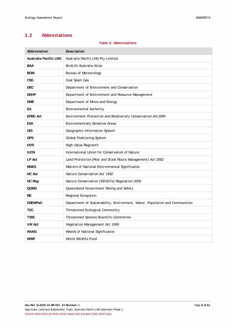
1.2 Abbreviations Table 2: Abbreviations
Abbreviation Description
Australia Pacific LNG Australia Pacific LNG Pty Limited
BAA BirdLife Australia Atlas
BOM Bureau of Meteorology
CSG Coal Seam Gas
DEC Department of Environment and Conservation
DEHP Department of Environment and Resource Management
DME Department of Mines and Energy
EA Environmental Authority
EPBC Act Environment Protection and Biodiversity Conservation Act1999
ESA Environmentally Sensitive Areas
GIS Geographic Information System
GPS Global Positioning System
HVR High Value Regrowth
IUCN International Union for Conservation of Nature
LP Act Land Protection (Pest and Stock Route Management) Act 2002
MNES Matters of National Environmental Significance
NC Act Nature Conservation Act 1992
NC Reg Nature Conservation (Wildlife) Regulation 2006
QGMS Queensland Government Mining and Safety
RE Regional Ecosystem
DSEWPaC Department of Sustainability, Environment, Water, Population and Communities
TEC Threatened Ecological Community
TSSC Threatened Species Scientific Committee
VM Act Vegetation Management Act 1999
WoNS Weeds of National Significance
WWF World Wildlife Fund

Ecology Assessment Report 46BWR274
Doc Ref: Q-4550-15-RP-001_34 Revision: 0 Page 9 of 61
Approvals, Land and Stakeholder Team, Australia Pacific LNG Upstream Phase 1
Uncontrolled when printed unless issued and stamped Controlled Copy.
1.3 Document References Table 3: Associated document references
Document Number
Title
1 BirdLife Australia’s Atlas (BAA, 20012). Birdata, BirdLife Australia, WildlifeLink and Geographic Web Solutions. Available from: http://www.birdata.com.au/community_front.vm , Accessed 7 June 2012.
2 Bureau of Meteorology (BOM, 2013). Climate data online. Available from: http://www.bom.gov.au/climate/data/, Accessed on 12 February 2013.
3 Churchill, S. (2009). Australian Bats, Second Edition, Allen and Unwin, Crows Nest.
4 Department of Environment and Conservation (DEC, 2005). Ooline – Profile. Office of Environment and Heritage, NSW, Sydney. Available from: http://www.threatenedspecies.environment.nsw.gov.au/tsprofile/profile.aspx?id=10118 , Accessed on 14 May 2012.
5 Department of Environment and Heritage Protection (DEHP, 2006). Red Goshawk Erythrotriorchis radiatus, Conservation Management Profile. Available from: http://www.ehp.qld.gov.au/register/p02093aa.pdf, Accessed on 30 May 2012.
6 Department of Environment and Heritage Protection (DEHP, 2010). Golden-tailed gecko. Available from: http://www.ehp.qld.gov.au/wildlife/threatened-species/near-threatened/goldentailed_gecko.html, Accessed on 31 May 2012.
7 Department of Environment and Heritage Protection (DEHP, 2012a). Regrowth Vegetation Map (Version 2.1). Available from: http://www.derm.qld.gov.au/wildlife-ecosystems/biodiversity/regional_ecosystems/introduction_and_status/regional_ecosystem_maps/index.php#lot , Accessed on 4 April 2012.
8 Department of Environment and Heritage Protection (DEHP, 2012b). Environmentally Sensitive Area – Mining Activities Map. Available from: http://www.ehp.qld.gov.au/licences-permits/maps_of_environmentally_sensitive_areas.php, Accessed on 4 April 2012.
9 Department of Environment and Heritage Protection (DEHP, 2012c). VMA Essential Habitat Map (Version 3.1). Available from: http://www.derm.qld.gov.au/wildlife-ecosystems/biodiversity/regional_ecosystems/introduction_and_status/regional_ecosystem_maps/index.php#lot, Accessed on 4 April 2012.
10 Department of Environment and Heritage Protection (DEHP, 2012d). Referable Wetlands mapping. Available from: http://www.derm.qld.gov.au/wildlife-ecosystems/ecosystems/referable-wetlands-form.php , Accessed on 4 April 2012.
11 Department of Environment and Heritage Protection (DEHP, 2012e). Wetland Maps. Available from: http://wetlandinfo.ehp.qld.gov.au/wetlands/MappingFandD/WetlandMapsAndData/WetlandMaps.html, Accessed on 4 April 2012.
12 Department of Environment and Heritage Protection (DEHP, 2013a). VMA Regional Ecosystem and Remnant Map (Version 7). Available from: http://www.derm.qld.gov.au/wildlife-ecosystems/biodiversity/regional_ecosystems/introduction_and_status/regional_ecosystem_maps/index.php#lot, Accessed on 12 February 2013.
13 Department of Environment and Heritage Protection (DEHP, 2013b). Wildlife Online. Available from: http://www.derm.qld.gov.au/wildlife-ecosystems/wildlife/wildlife_online, Accessed on 24 January 2013.
14 Department of Environment and Heritage Protection (DEHP) Environmental Authority (EA) issued for the Walloons project area by the DEHP (PEN100067807).
15 Department of Sustainability, Environment, Water, Population and Communities (DSEWPaC, 2008a). Approved conservation advice for Pterostylis cobarensis (Cobar greenhood Orchid). Available from:
Ecology Assessment Report 46BWR274
Doc Ref: Q-4550-15-RP-001_34 Revision: 0 Page 10 of 61
Approvals, Land and Stakeholder Team, Australia Pacific LNG Upstream Phase 1
Uncontrolled when printed unless issued and stamped Controlled Copy.
Document Number
Title
http://www.environment.gov.au/biodiversity/threatened/species/pubs/12993-conservation-advice.pdf, Accessed on 30 May 2012.
16 Department of Sustainability, Environment, Water, Population and Communities (DSEWPaC, 2008b). Approved conservation advice for Tylophora linearis. Available from: http://www.environment.gov.au/biodiversity/threatened/species/pubs/55231-conservation-advice.pdf, accessed on 10 April 2012.
17 Department of Sustainability, Environment, Water, Population and Communities (DSEWPaC, 2008c). Approved conservation advice for Westringia parvifolia. Available from: http://www.environment.gov.au/biodiversity/threatened/species/pubs/4822-conservation-advice.pdf, Accessed on 10 April 2012.
18 Department of Sustainability, Environment, Water, Population and Communities (DSEWPaC) (2009). EPBC Act Approval 2009/4974.
19 Department of Sustainability, Environment, Water, Population and Communities (DSEWPaC, 2012a). Brigalow (Acacia harpophylla dominant and co-dominant) in Species Profile and Threats Database, Department of Sustainability, Environment, Water, Population and Communities, Canberra. Available from: http://www.environment.gov.au/sprat, Accessed on 30 May 2012.
20 Department of Sustainability, Environment, Water, Population and Communities (DSEWPaC, 2012b). Neochmia ruficauda ruficauda in Species Profile and Threats Database, Department of Sustainability, Environment, Water, Population and Communities, Canberra. Available from: http://www.environment.gov.au/sprat, Accessed on 30 May 2012.
21 Department of Sustainability, Environment, Water, Population and Communities (DSEWPaC, 2012c). Rostratula australis – Australian Painted Snipe in Species Profile and Threats Database, Department of Sustainability, Environment, Water, Population and Communities, Canberra. Available from: http://www.environment.gov.au/sprat , Accessed on 30 May 2012.
22 Department of Sustainability, Environment, Water, Population and Communities (DSEWPaC, 2012d). Chalinolobus dwyeri — Large-eared Pied Bat, Large Pied Bat, in Species Profile and Threats Database, Department of Sustainability, Environment, Water, Population and Communities, Canberra. Available from: http://www.environment.gov.au/sprat Accessed on 30 May 2012.
23 Department of Sustainability, Environment, Water, Population and Communities (DSEWPaC, 2012e). Nyctophilus corbeni— South-eastern Long-eared Bat in Species Profile and Threats Database, Department of Sustainability, Environment, Water, Population and Communities, Canberra. Available from: http://www.environment.gov.au/sprat, Accessed on 30 May 2012.
24 Department of Sustainability, Environment, Water, Population and Communities (DSEWPaC, 2012f). Anomalopus mackayi— Five-clawed Worm-skink, Long-legged Worm-skink, in Species Profile and Threats Database, Department of Sustainability, Environment, Water, Population and Communities, Canberra. Available from: http://www.environment.gov.au/sprat, Accessed on 30 May 2012.
25 Department of Sustainability, Environment, Water, Population and Communities (DSEWPaC, 2012g). Delma torquata in Species Profile and Threats Database, Department of Sustainability, Environment, Water, Population and Communities, Canberra. Available from: http://www.environment.gov.au/sprat, Accessed on 30 May 2012.
26 Department of Sustainability, Environment, Water, Population and Communities (DSEWPaC, 2012h). Denisonia maculata in Species Profile and Threats Database, Department of Sustainability, Environment, Water, Population and Communities, Canberra. Available from: http://www.environment.gov.au/sprat, Accessed 30 May 2012.
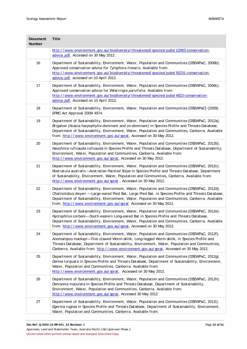
27 Department of Sustainability, Environment, Water, Population and Communities (DSEWPaC, 2012i). Egernia rugosa in Species Profile and Threats Database, Department of Sustainability, Environment, Water, Population and Communities, Canberra. Available from:
Ecology Assessment Report 46BWR274
Doc Ref: Q-4550-15-RP-001_34 Revision: 0 Page 11 of 61
Approvals, Land and Stakeholder Team, Australia Pacific LNG Upstream Phase 1
Uncontrolled when printed unless issued and stamped Controlled Copy.
Document Number
Title
http://www.environment.gov.au/sprat, Accessed on 30 May 2012.
28 Department of Sustainability, Environment, Water, Population and Communities (DSEWPaC, 2012j). Furina dunmalli in Species Profile and Threats Database, Department of Sustainability, Environment, Water, Population and Communities, Canberra. Available from: http://www.environment.gov.au/sprat, Accessed on 30 May 2012.
29 Department of Sustainability, Environment, Water, Population and Communities (DSEWPaC, 2012k). Paradelma orientalis in Species Profile and Threats Database, Department of Sustainability, Environment, Water, Population and Communities, Canberra. Available from: http://www.environment.gov.au/sprat, Accessed 28 June 2012.
30 Department of Sustainability, Environment, Water, Population and Communities (DSEWPaC, 2012l). Species Profile and Threats Database (search undertaken for all Migratory species), Department of Sustainability, Environment, Water, Population and Communities, Canberra. Available from: http://www.environment.gov.au/sprat, Accessed on 30 May 2012.
31 Department of Sustainability, Environment, Water, Population and Communities (DSEWPaC, 2013). Protected Matters Search Tool, Department of Sustainability, Environment, Water, Population and Communities, Canberra. Available from: http://www.environment.gov.au/epbc/pmst/index.html, Accessed on 24 January 2013.
32 Ellis, M. & Pennay, M. (2008) Chalinolobus picatus. In: IUCN 2012. IUCN Red List of Threatened Species. Version 2012.2. <www.iucnredlist.org>. Downloaded on 26 February 2013.
33 Environment Protection and Biodiversity Conservation Act 1999. Available from: http://www.comlaw.gov.au/Details/C2012C00248 , Accessed on 14 May 2012.
34 Eyre, T.J., Kelly, A.L., Neldner, V.J., Wilson, B.A., Ferguson, D.J., Laidlaw, M.J. and Franks, A.J. (2011). BioCondition: A Condition Assessment Framework for Terrestrial Biodiversity in Queensland. Assessment Manual. Version 2.1. Department of Environment and Heritage Protection (DEHP), Biodiversity and Ecosystem Sciences, Brisbane.
35 Garnett, S. (1992). Threatened and Extinct Birds of Australia. Royal Australian Ornithologists Union and Australian National Parks and Wildlife Service, Canberra. Available from: http://www.environment.gov.au/cgi-bin/sprat/public/publicspecies.pl?taxon_id=25934 , Accessed on 30 May 2012.
36 Glossy Black Conservancy (2010). Glossy Black-Cockatoo Conservation Guidelines for South-Eastern Queensland and Far North-Eastern New South Wales. Glossy Black Conservancy.
37 Higgins, P.J. (ed.) (1999). Handbook of Australian, New Zealand and Antarctic Birds. Volume Four - Parrots to Dollarbird. Oxford University Press, Melbourne.
38 Land Protection (Pest and Stock Route Management) Act 2003. Available from:http://www.legislation.qld.gov.au/LEGISLTN/CURRENT/L/LandPrPSRMR03.pdf, Accessed on 14 May 2012.
39 Marchant S and Higgins PJ (Eds) (1993). Handbook of Australian, New Zealand and Antarctic Birds
(vol. 2), Oxford University Press: Melbourne
40 Maxwell, S., Burbidge, A.A. and Morris, K (eds) (1996). Action Plan for Australian Marsupials and Monotremes. Environment Australia, Canberra.
41 National Murray Cod Recovery Team (2009). Draft National Recovery Plan for the Murray Cod Maccullochella peelii peelii. Department of Sustainability and Environment, Melbourne.
42 Nature Conservation Act 1992. Available from: http://www.legislation.qld.gov.au/legisltn/current/n/naturecona92.pdf, Accessed on 30 May 2012.
43 Nature Conservation (Wildlife) Regulation 2006. Available from:

Ecology Assessment Report 46BWR274
Doc Ref: Q-4550-15-RP-001_34 Revision: 0 Page 12 of 61
Approvals, Land and Stakeholder Team, Australia Pacific LNG Upstream Phase 1
Uncontrolled when printed unless issued and stamped Controlled Copy.
Document Number
Title
http://www.legislation.qld.gov.au/LEGISLTN/CURRENT/N/NatureConWiR06.pdf, Accessed on 30 May 2012.
44 Neldner, V.J., Wilson, B. A., Thompson, E.J. and Dillewaard, H. A. (2012). Methodology for survey and mapping of regional ecosystems and vegetation communities in Queensland. Version 3.1 Updated August 2012. Queensland Herbarium, Environmental Protection Agency, Brisbane.
Q-LNG01-15-MP-0109
Origin Energy (2012) Environmental Constraints Planning and Field Development Protocol for Australia Pacific LNG Pty Limited
45 Queensland Government Mining and Safety (QGMS, 2011). Geoscience and Resource Information, Digital Geological Mapping Data, Available from: http://mines.industry.qld.gov.au/geoscience/digital-geological-mapping-data.htm , Accessed on 12 February 2013.
46 Queensland Herbarium (2012). HERBRECS database, Brisbane.
47 Rangelands (2008). Taking the Pulse – Brigalow Belt South bioregion. Available from: http://www.environment.gov.au/land/publications/acris/pubs/bioregion-brigalow-belt-south.pdf, Accessed 08 April 2012.
48 Sattler, P. S., and Williams, R. D., (editors). (1999). The conservation status of Queensland's bioregional ecosystems. Environmental Protection Agency, Brisbane.
49 Trémont, R.M. and Whalley, D.B. (1993). Final Report for Survey for Homopholis belsonii. Toowoomba and Region Environment Council Inc, Toowoomba.
50 Threatened Species Scientific Committee (TSSC, 2008a). Commonwealth Listing Advice on Natural grasslands on basalt and fine-textured alluvial plains of northern New South Wales and southern Queensland. Available from: http://www.environment.gov.au/cgi-bin/sprat, Accessed 30 May 2012.
51 Threatened Species Scientific Committee (TSSC, 2008b). Commonwealth Listing Advice on Weeping Myall Woodlands. Available from: http://www.environment.gov.au/cgi-bin/sprat/public/publicshowcommunity.pl?id=98, Accessed 30 May 2012.
52 Threatened Species Scientific Committee (TSSC, 2011). Commonwealth Listing Advice on Coolibah - Black Box Woodlands of the Darling Riverine Plains and the Brigalow Belt South Bioregions. Available from: http://www.environment.gov.au/cgi-bin/sprat, Accessed 30 May 2012.
53 Vegetation Management Act 1999. Available from: http://www.legislation.qld.gov.au/legisltn/current/v/vegetmana99.pdf, Accessed on 4 April 2012.
54 World Wildlife Fund (WWF) (2008). Brigalow Belt bioregion – a biodiversity jewel. Available from: http://www.qmdc.org.au/publications/download/49/fact-sheets-case-studies/reptile-recovery/the-brigalow-belt-bioregion.pdf, Accessed on 14 May 2012.

Ecology Assessment Report 46BWR274
Doc Ref: Revision: 0 Page 13 of 61
Approvals, Land and Stakeholder Team, Australia Pacific LNG Upstream Phase 1
Uncontrolled when printed unless issued and stamped Controlled Copy.
2.0 Introduction RPS was commissioned by Origin Energy Pty Ltd (Origin) to prepare this ecological assessment report to identify ecological constraints and opportunities for seismic surveying of Lot 46 on BWR274, hereafter referred to as the Site.
This report and associated field surveys were completed by a team of three RPS Ecologists, led by Brad Dreis, Senior Ecologist (approved by DSEWPaC in writing on 14/09/2012). This report provides a description of the Site’s ecological values, including significance and extent of vegetation, habitat and species, as determined from desktop and field investigations.
2.1 Scope of Work The purpose of the ecological assessment survey was to identify ecological features within the Site to inform placement of seismic lines, so that environmental impacts can be avoided and minimised. This report addresses conditions within the Commonwealth Environment Protection and Biodiversity Conservation Act 1999 (EPBC Act) approval 2009/4974 and the Environmental Authority (EA) issued for the Walloons project area by the Department of Environment and Heritage Protection (DEHP) (PEN100067807). Survey requirements include:
• Verification of Queensland DEHP Regional Ecosystem (RE) and High Value Regrowth (HVR) mapping and creation of ground-truthed RE and HVR maps
• Observation and mapping of Category A, B and C Environmentally Sensitive Areas (ESAs)
• Observation and mapping of significant vegetation communities, including Threatened Ecological Communities (TECs) identified under the EPBC Act
• Observation and mapping of endangered, vulnerable, or near threatened flora and fauna species listed under the EPBC Act and Queensland Nature Conservation (Wildlife) Regulation 2006 (NC Reg). In addition, observation and mapping of suitable threatened species habitat
• Mapping of pre-existing areas of significant disturbance within Category B or C ESA
• Assessment of habitat quality and analysis of likelihood of occurrence of threatened flora and fauna species listed under the EPBC Act and NC Reg
• Identification of opportunities for placement of seismic lines, such as areas cleared of vegetation, and areas of lower value vegetation
• Identification of areas of significant weed or pest infestation, and known feral animals
• Provision of Site-specific management recommendations to minimise impacts.
The ecological assessment survey was undertaken within Lot 46 on BWR274, located within the northern section of Dalwogan, west of Miles, Queensland (Figure 1). The survey was undertaken in accordance with Origin’s Ecological Assessment Guidelines (Origin Energy, 2012) and all work was compliant with relevant legislation. The Dalwogan area comprises part of the Walloons Environmental Authority (EA) PEN10067807.

X-XXXX-XX-XX-XXXX
Dalwogan EcologicalSurvey
QueenslandFigure 1
Date:
Orig
in E
nerg
y Lt
d gi
ves
no w
arra
nty
in re
latio
n to
the
data
(inc
ludi
ng a
ccur
acy,
relia
bilit
y, c
ompl
eten
ess
or s
uita
bilit
y) a
nd a
ccep
ts n
o lia
bilit
y fo
r any
loss
, dam
age
or c
osts
(inc
ludi
ng c
onse
quen
tial d
amag
e) re
latin
g to
any
use
of t
he d
ata
in th
is m
ap.
State:
Map No:Map ID: Doc ID:
Project:REVISIONS
REV DESCRIPTION DATE
A Issued for Use
Dalwogan Area Locality Map
24/01/2013
1 of 9
NAME SIGNATURE
DRAWN
CHECK
QA
APP
Projection: MGA94 Z56 Units: Kilometres Scale 1:70,000 @ A3
Locations indicative and subject to changeDigital Cadastral Database © The State of Queensland (DERM) 2012.
01/08/2012 CO
KM
HR
BD
Miles
Dalwogan North
³
Dalwogan South
1,400 0 1,400700 Meters
Lot 46 on BWR274
Dalwogan Survey AreaExcluded location
Survey Area
Butle
rs Ro
ad
Warrego Hwy
Leichhardt Hwy

Ecology Assessment Report 46BWR274
Doc Ref: Q-4550-15-RP-001_34 Revision: 0 Page 15 of 61
Approvals, Land and Stakeholder Team, Australia Pacific LNG Upstream Phase 1
Uncontrolled when printed unless issued and stamped Controlled Copy.
2.2 Site Context
2.3 Location The Site is located in the area of the Walloons EA known as ‘Dalwogan’, 5 km west of Miles in the Western Downs Regional Council Local Government Area. It is dissected north-south by the Warrego highway and is bounded on the northeast by the Leichhardt highway and on the southeast by Butlers Road (Figure 1).
The Dalwogan area is comprised of the following 40 land parcels:
• Lot 4 and 5 BWR 218
• Lot 80 and 81 on BWR 363
• Lot 61 on BWR 361
• Lot 50 on BWR 276
• Lot 53, 58, 59, 60, 62 and 63 on BWR 279
• Lot 8 on BWR 349
• Lot 36 and 54 on BWR 601
• Lot 1 and 2 on RP 227977
• Lot 57 on BWR 276
• Lot 52 on RP 896373
• Lot 2 and 11 on BWR 421
• Lot 13 on BWR405
• Lot 1 and 2 on RP 211457
• Lot 1 and 2 on RP 175899
• Lot 56 and 57 on BWR 273
• Lot 44, 45, 46, 48 and 51 BWR 274
• Lot 13 on BWR 789
• Lot 1, 2 and 4 on RP 175900
• Lot 5 and 6 on RP 175901
• Lot 22 on SP 132024.
This report focuses on Lot 46 on BWR274. This lot is located in the southern section of the Dalwogan Site area and covers an area of around 264 hectares (Figure 1).
Ecology Assessment Report 46BWR274
Doc Ref: Q-4550-15-RP-001_34 Revision: 0 Page 16 of 61
Approvals, Land and Stakeholder Team, Australia Pacific LNG Upstream Phase 1
Uncontrolled when printed unless issued and stamped Controlled Copy.
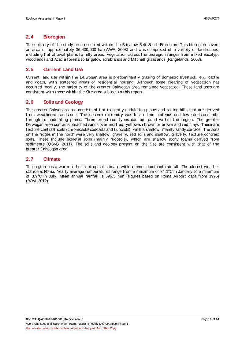
2.4 Bioregion The entirety of the study area occurred within the Brigalow Belt South Bioregion. This bioregion covers an area of approximately 36,400,000 ha (WWF, 2008) and was comprised of a variety of landscapes, including flat alluvial plains to hilly areas. Vegetation across the bioregion ranges from mixed Eucalypt woodlands and Acacia forests to Brigalow scrublands and Mitchell grasslands (Rangelands, 2008).
2.5 Current Land Use Current land use within the Dalwogan area is predominantly grazing of domestic livestock, e.g. cattle and goats, with scattered areas of residential housing. Although some clearing of vegetation has occurred locally, the majority of the greater Dalwogan area remained vegetated. These land uses are consistent with those within the Site area subject to this report.
2.6 Soils and Geology The greater Dalwogan area consists of flat to gently undulating plains and rolling hills that are derived from weathered sandstone. The eastern extremity was located on plateaus and low sandstone hills through to undulating plains. Three broad soil types can be found within the region. The greater Dalwogan area contains bleached sands over mottled, yellowish brown or brown and red clays. These are texture contrast soils (chromosols/sodosols and kurosols), with a shallow, mainly sandy surface. The soils on the ridges in the north were very shallow, gravelly, red soils and shallow, gravelly, texture contrast soils. These include skeletal soils (mainly rudosols), which are shallow stony loams derived from sediments (QGMS, 2011). The soils and geology present on the Site are consistent with that of the greater Dalwogan area.
2.7 Climate The region has a warm to hot subtropical climate with summer-dominant rainfall. The closest weather station is Roma. Yearly average temperatures range from a maximum of 34.1oC in January to a minimum of 3.9oC in July. Mean annual rainfall is 596.5 mm (figures based on Roma Airport data from 1995) (BOM, 2012).
Ecology Assessment Report 46BWR274
Doc Ref: Q-4550-15-RP-001_34 Revision: 0 Page 17 of 61
Approvals, Land and Stakeholder Team, Australia Pacific LNG Upstream Phase 1
Uncontrolled when printed unless issued and stamped Controlled Copy.
3.0 Methodology The ecological assessment surveys consisted of both desktop and field investigations.
3.1 Desktop and Literature Review The following sources were reviewed to obtain information for the desktop and literature review as follows:
• EPBC Act Protected Matters Search Tool (DSEWPaC, 2013)
• DEHP Remnant Ecosystem and Remnant Vegetation map, version 7 digital GIS layer (DEHP, 2013)
• DEHP Regrowth Vegetation map, version 2.1 digital GIS layer (DEHP, 2012a)
• DEHP Environmentally Sensitive Areas (ESA) (DEHP, 2012b)
• DEHP Essential Habitat map, version 3.1, digital GIS layer (DEHP, 2012c)
• DEHP Referrable Wetlands database (DEHP, 2012d)
• DEHP Queensland Wetlands map, version 2.0. (DEHP, 2012e)
• DEHP Wildlife Online Database (DEHP, 2013b)
• Queensland Herbarium HERBRECS database (Queensland Herbarium 2012)
• Queensland Museum database (Queensland Museum, 2012)
• BirdLife Australia’s Atlas, Birdata (BAA, 2012).
EPBC Act Protected Matters and NC Reg Wildlife Online searches were conducted using a 10 km buffer around the Global Positioning System (GPS) coordinates -26.61999, 150.12924, which corresponded to the approximate centre point of the Dalwogan north area.
3.2 Field Survey Ecological assessment surveys were undertaken in general accordance with the BioCondition – A Condition Assessment Framework for Terrestrial Biodiversity in Queensland – Assessment Manual – Version 2.1 (Biocondition Manual) (Eyre et al., 2011) and the Methodology for Survey and Mapping of Regional Ecosystems and Vegetation Communities in Queensland (Neldner et al., 2012).
3.2.1 Site Selection
Prior to undertaking the field survey, target survey plots were selected using aerial photography and DEHP mapping (e.g. RE, HVR and wetland maps), to ensure representation of the different vegetation and habitat types present on the Site. At least one plot was surveyed for each vegetation/habitat type. Additional plots were also surveyed during field work when differences between the RE mapping and ground-truthing were identified. The survey points represented in Figure 2 represent the central point of the vegetation plots, opportunistic and targeted surveys on Sites.

X-XXXX-XX-XX-XXXX
Dalwogan Ecological Survey
QueenslandFigure 2
Date:
Orig
in E
nerg
y Lt
d gi
ves
no w
arra
nty
in r
elat
ion
to th
e da
ta (
incl
udin
g ac
cura
cy, r
elia
bilit
y, c
ompl
eten
ess
or s
uita
bilit
y) a
nd a
ccep
ts n
o lia
bilit
y fo
r any
loss
, dam
age
or c
osts
(in
clud
ing
cons
eque
ntia
l dam
age)
rel
atin
g to
any
use
of t
he d
ata
in th
is m
ap.
State:
Map No:Map ID: Doc ID:
Project:REVISIONS
REV DESCRIPTION DATE
1 Issued for Use
Survey Locations Map
01/08/2012
2 of 9
NAME SIGNATURE
DRAWN
CHECK
QA
APP
Projection: MGA94 Z56 Units: Kilometres Scale 1:8,000 @ A3
Locations indicative and subject to changeDigital Cadastral Database © The State of Queensland (DERM) 2012.
1
32 1
1
1
01/08/2012 CO
KM
HR
BD
150 0 15075 Meters
³
Lot 46 on BWR274
Stream Orders
Survey Points
Ecology Assessment Report 46BWR274
Doc Ref: Q-4550-15-RP-001_34 Revision: 0 Page 19 of 61
Approvals, Land and Stakeholder Team, Australia Pacific LNG Upstream Phase 1
Uncontrolled when printed unless issued and stamped Controlled Copy.
3.2.2 Vegetation Community Survey
General baseline botanical surveys were undertaken to describe dominant flora and vegetation community structure throughout the Site. Botanical surveys were consistent with the tertiary and quaternary level of data collection as described in Methodology for Survey and Mapping of Regional Ecosystems and Vegetation Communities in Queensland (Neldner et al., 2012). All plant identifications for tertiary and quaternary surveys were carried out by experienced ecologists using available botanical reference material.
Vegetation community surveys were conducted within a 100 m by 50 m quadrat in each survey plot. The following information was recorded:
• Flora species within each vegetation stratum and their dominance
• Structural formation and ecologically dominant vegetation layer
• Observed RE/HVR and conservation status
• Cover density, height range and median height of each vegetation layer
• Connectivity of vegetation patch.
When traversing the Site by foot, opportunistic flora observations were recorded outside survey plots for threatened flora species, pest flora and Type A plants.
The mapping data for each vegetation community were entered into a Trimble Nomad Global Positioning System (GPS) and then used to cross-check the accuracy of RE and HVR mapping with the by DEHP mapping (DEHP, 2013a).
All regrowth and remnant vegetation community boundaries (polygons) were confirmed, mapped and identified in accordance with DEHP RE (biodiversity status) and EPBC Act threatened ecological community (TEC) criteria. Photos of all vegetation structure and threatened species were taken using the Trimble unit, which recorded the GPS coordinates and the aspect data.
3.2.3 Habitat Survey
Habitat surveys were conducted within a 50 m by 10 m quadrat in each survey plot. All faunal habitat features were recorded, in order to assess the likelihood of significant species occurring in the area. The habitat features recorded include:
• Density of ground and shrub layers
• Presence of logs
• Presence of tree hollows
• Presence of trees supporting loose bark
• Presence of fallen bark and leaf litter
• Presence of rocks and rocky outcrops
• Presence of termite mounds
• Presence of mistletoe
• Presence of nests or other fauna signs, like scats, scratching and diggings
• Presence of wetland features.
Opportunistic fauna observations were also recorded, as well as habitat features with particular significance (e.g. a large tree with an unusual number of hollows). Any significant features observed are described in 4.2.
Ecology Assessment Report 46BWR274
Doc Ref: Q-4550-15-RP-001_34 Revision: 0 Page 20 of 61
Approvals, Land and Stakeholder Team, Australia Pacific LNG Upstream Phase 1
Uncontrolled when printed unless issued and stamped Controlled Copy.
3.2.4 Threatened Flora and Fauna Survey
Potential habitats for threatened flora and fauna species were identified from desktop research prior to fieldwork. This enabled targeted habitat searches to be undertaken in the field. For the purposes of this assessment, Threatened species were defined as are those listed under the EPBC Act 1999 and/or the Queensland Nature Conservation (Wildlife) Regulation 2006.
Targeted flora searches were undertaken in vegetation communities or specific habitats that are preferred by the threatened species of interest, with additional searches undertaken in good quality habitat areas identified in the field. Targeted flora searches were also undertaken where sightings had been previously reported in order to confirm species presence.
Targeted threatened species surveys were also conducted in additional locations based on incidental field observations of high quality habitat or identification of distinct ecological features through preliminary review of mapping and other background information for the property. As these searches were informal the specific survey locations are not reflected in Figure 2.
An Anabat recorder was used to record the calls of microchiropteran bats on Site. The recorder was placed over night in a number of suitable locations. Digitised bat calls were analysed by an Anabat specialist.
3.2.5 Exotic Flora and Fauna Survey
Environmental and declared pest species, as defined by the Land Protection (Pest and Stock Route Management) Act 2002 (LP Act) were noted, with their abundance and GPS location both recorded.
3.2.6 Disturbance Survey
Evidence of disturbance was identified and the following attributes recorded: disturbance type, severity and estimated time of most recent occurrence. Types of disturbances recorded include track and waterway erosion, evidence of vegetation thinning and clearing, evidence of fire and gravel extraction and dump Sites.
3.2.7 Survey Limitations
The ability to detect plants and accurately identify them to species level can vary greatly with season, prevailing climatic conditions and the presence of reproductive material (e.g. flowers, fruit and seed capsules). Given that the current surveys represent a snapshot in time, they may not provide a true indication of plant presence at the Site. For example, some cryptic flora species may only be detected during particular flowering periods that were not present during the current survey. Hence, this survey should not be regarded as conclusive evidence that certain protected plants do not occur at the Site. However, every effort has been made to detect these species in their preferred habitat areas.
Areas of the property that were not directly surveyed were assessed using high quality aerial imagery and mapping datasets to refine RE mapping boundaries. Potential habitats for threatened flora and fauna species were identified by a combination of: previous field surveys undertaken, database searches, inspection of aerial imagery and extensive field experience. Detailed fauna surveys (i.e. trapping) were not undertaken as part of this assessment.

Ecology Assessment Report 46BWR274
Doc Ref: Q-4550-15-RP-001_34 Revision: 0 Page 21 of 61
Approvals, Land and Stakeholder Team, Australia Pacific LNG Upstream Phase 1
Uncontrolled when printed unless issued and stamped Controlled Copy.
4.0 Results and Discussion This section presents the results of the desktop and field assessment plus interpretation and discussion of key findings. Some results (e.g. EPBC Act searches) relate to the broader Dalwogan area while others relate to the Site (Lot 46 on BWR274).
4.1 Desktop and Literature Review Data sources used during desktop searches for the Dalwogan area are listed in Section 3.1. A summary of the results is presented below.
4.1.1 Matters of National Environmental Significance
There are 4 different MNES that occur or have the potential to occur within the Dalwogan area (DSEWPaC, 2013 and Appendix A). These include: wetlands of international significance, TECs, threatened fauna/flora species and migratory species.
4.1.1.1 Threatened Ecological Communities
According to the EPBC Act Protected Matters Search Tool results (Appendix A ), 4 TECs occurred or have the potential to occur within the Dalwogan area (Table 4). In Queensland, these TECs have been defined with reference to the RE framework as they have known associations with specific REs.
Based on the DEHP RE mapping (DEHP, 2013a) for the Dalwogan area; the Brigalow, Coolibah and Weeping Myall TECs are considered possibilities of occurring due to the presence of their associated REs. The remaining TEC was considered unlikely to occur as the associated REs are not mapped within the Dalwogan area (Section 4.1.6).
At the Site, none of the TECs presented in Table 4 were considered likely to occur as none of their associated REs are mapped for the Site (Section 4.1.6).
Table 4: for Threatened Ecological Communities to occur within the Dalwogan area
Name EPBC Act Status
RE Associations Likelihood of Occurrence within the Dalwogan Area
Brigalow (Acacia harpophylla dominant and co-dominant)
Endangered 11.3.1, 11.4.3, 11.4.7, 11.4.8, 11.4.9, 11.4.10, 11.5.16, 11.9.1, 11.9.5, 11.9.6, 11.11.14, 11.12.21 (DSEWPaC, 2013a).
Possible
Species or species habitat may occur within area.
Coolibah – Black Box Woodlands of the Darling Riverine Plains and the Brigalow Belt South Bioregions
Endangered 11.3.3, 11.3.15, 11.3.16, 11.3.28, 11.3.37 (TSSC, 2011).
Possible
Species or species habitat may occur within area.
Natural grasslands on basalt and fine textured alluvial plains of northern New South Wales and southern Queensland
Critically Endangered
11.3.21, 11.3.24 (TSSC, 2008a)
Unlikely
Species or species habitat are not present within area.
Weeping Myall Woodlands Endangered 11.3.2, 11.3.28 (TSSC, 2008b)
Possible
Species or species habitat may occur within area.

Ecology Assessment Report 46BWR274
Doc Ref: Q-4550-15-RP-001_34 Revision: 0 Page 22 of 61
Approvals, Land and Stakeholder Team, Australia Pacific LNG Upstream Phase 1
Uncontrolled when printed unless issued and stamped Controlled Copy.
4.1.1.2 Listed Flora
According to the EPBC Act Protected Matters Search Tool results (Appendix A) and the distribution of the species, 5 threatened flora species potentially occurred within the Dalwogan area (Table 5). Based on RE vegetation descriptions for the greater Dalwogan area (Section 4.1.6), 4 species possibly occurred due to the presence of suitable habitat. The other species were considered unlikely to occur because the Dalwogan area is outside their known distribution.
At the Site, only one of these species (Belson’s Panic) was considered to potentially occur due to the presence of suitable habitat. Potential habitat for this species includes RE 11.5.1a (Eucalyptus populnea woodland with Allocasuarina luehmannii low tree layer), which is mapped over the majority of the Site (Section 4.1.6).
4.1.1.3 Listed Fauna
According to the EPBC Act Protected Matters Search Tool results (Appendix A) and the distribution of fauna species, 14 threatened fauna species occurred within the greater Dalwogan area (Table 6). This includes: 5 birds, 3 mammals, 1 fish and 5 reptile species.
One species, the Squatter Pigeon (southern) (Geophaps scripta scripta) was likely to occur within the greater Dalwogan area and ten other species were considered as possible occurrences. This is based on the known distribution of species and the availability of suitable habitat (Eyre et al, 2011). The likelihood of occurrence for all species is shown in Table 6.

Ecology Assessment Report 46BWR274
Doc Ref: Q-4550-15-RP-001_34 Revision: 0 Page 23 of 61
Approvals, Land and Stakeholder Team, Australia Pacific LNG Upstream Phase 1
Uncontrolled when printed unless issued and stamped Controlled Copy.
Table 5: Potential for threatened flora species to occur within the Dalwogan area
Scientific Name Common Name EPBC Act Status Habitat Likelihood of Occurrence within the Dalwogan Area
Cadellia pentastylis Ooline Vulnerable Growth in dry forest, semi-evergreen vine thickets and sclerophyll ecological communities. It can be locally dominant or as an emergent. The known distribution of this species overlaps with the Semi-Evergreen Vine Thickets of the Brigalow Belt and Nandewar Bioregions, the Brigalow ecological communities and the White Box-Yellow Box-Blakely’s Red Gum Grassy Woodland and Derived Native Grassland Communities (DEC, 2005).
Possible
Species may occur within area as preferred vegetation communities may occur within the greater Dalwogan area.
Homopholis belsonii
Belson’s Panic Vulnerable Known to occur within the southern Brigalow Belt, Queensland and on the north-western slopes and plains of NSW on dry woodland on poor soils, rocky hills, flat to gently undulating alluvial areas supporting Belah (Casuarina cristata) forest or on soils and plant communities of Poplar Box (E. populnea) (Trémont & Whalley, 1993). The distribution of this species overlaps with the Brigalow (Acacia harpophylla dominant and co-dominant) threatened ecological community.
Possible
Species may occur within area as preferred vegetation communities may occur within the greater Dalwogan area.

Ecology Assessment Report 46BWR274
Doc Ref: Q-4550-15-RP-001_34 Revision: 0 Page 24 of 61
Approvals, Land and Stakeholder Team, Australia Pacific LNG Upstream Phase 1
Uncontrolled when printed unless issued and stamped Controlled Copy.
Scientific Name Common Name EPBC Act Status Habitat Likelihood of Occurrence within the Dalwogan Area
Pterostylis cobarensis
Cobar Greenhood Orchid
Vulnerable This species inhabits Eucalypt woodland, open mallee, or Callitris shrubland on low stony ridges and slopes with skeletal sandy-loam soils. The known distribution of this species overlaps with the Semi-Evergreen Vine Thickets of the Brigalow Belt and Nandewar Bioregions, the Brigalow ecological communities and the White Box-Yellow Box-Blakely’s Red Gum Grassy Woodland and Derived Native Grassland communities and the Buloke Woodlands of Riverina and Murray-Darling Depression Bioregions (DSEWPaC, 2008a).
Possible
Species preferred vegetation communities do occur within the greater Dalwogan area.
Tylophora linearis Endangered Grows in dry scrub, open forest and woodlands associated with Melaleuca uncinata, Eucalyptus fibrosa, E. sideroxylon, E. albens, Callitris endlicheri, C. glaucophylla, Allocasuarina luehmannii, Acacia hakeoides, A. lineata, Myoporum spp., and Casuarina spp. The distribution of this species overlaps with the Brigalow (Acacia harpophylla dominant and co-dominant), and White Box-Yellow Box-Blakely’s Red Gum Grassy Woodland and Derived Native Grassland threatened ecological communities (DSEWPaC, 2008b).
Possible
Species preferred vegetation communities do occur within the greater Dalwogan area.
Westringia parvifolia
Vulnerable Known to occur from a small area near Yelarbon and Inglewood in south-east Queensland. This species occurs within the Border Rivers Maranoa–Balonne (Queensland) Natural Resource Management Region (DSEWPaC, 2008c).
Unlikely
Species preferred vegetation communities do not occur within the greater Dalwogan area.

Ecology Assessment Report 46BWR274
Doc Ref: Q-4550-15-RP-001_34 Revision: 0 Page 25 of 61
Approvals, Land and Stakeholder Team, Australia Pacific LNG Upstream Phase 1
Uncontrolled when printed unless issued and stamped Controlled Copy.
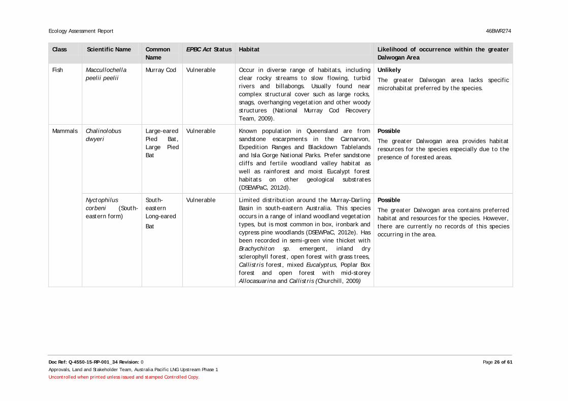
Table 6: Potential for threatened fauna species to occur within the Dalwogan area
Class Scientific Name Common Name
EPBC Act Status Habitat Likelihood of occurrence within the greater Dalwogan Area
Birds Erythrotriorchis radiatus
Red Goshawk
Vulnerable Occupies a range of habitat often at ecotones including coastal and sub-coastal tall open forest, tropical savannahs, woodlands and edge of rainforest and gallery forest along watercourses and wetlands that include Melaleuca and Casuarina species (DEHP, 2006).
Possible
The greater Dalwogan area provides habitat resources for the species especially due to the presence of riparian vegetation, wooded and forest land.
Geophaps scripta scripta
Squatter pigeon (southern)
Vulnerable Range from tropical, open dry sclerophyll woodlands and savannahs of north-eastern Australia. Prefer grassy understorey of Eucalyptus woodland close to permanent water bodies (Garnett, 1992). Tend to avoid dense grass cover (Eyre et al, 2011).
Likely
The greater Dalwogan area provides habitat resources for the species especially due to the presence of grassy riparian woodland.
Lathamus discolor Swift Parrot Endangered Occur in Eucalyptus forest and woodland, mainly box-ironbark habitats on the inland slopes of the Great Dividing range.
Unlikely
The Dalwogan area provides habitat resources for this species. However, the Dalwogan area is located on the edge of the species known habitat distribution.
Neochmia ruficauda ruficauda
Star Finch (eastern), Star Finch (southern)
Endangered Occurs in Queensland and its population is extremely limited within the Desert Channel, Burdekin and Fitzroy Natural Resource Management Regions (DSEWPaC, 2012b). Inhabit mainly grasslands, sedgelands and grassy woodlands that are located close to bodies of fresh water (Holmes, 1996).
Unlikely
The greater Dalwogan area is outside of the species known habitat distribution.
Rostratula australis
Australian Painted Snipe
Vulnerable Inhabits shallow terrestrial freshwater (occasionally brackish) wetlands, including temporary and permanent lakes, swamps and claypans (DSEWPaC, 2012c).
Possible
The greater Dalwogan area provides habitat resources for the species especially due to the presence of creeks and floodplain.
Ecology Assessment Report 46BWR274
Doc Ref: Q-4550-15-RP-001_34 Revision: 0 Page 26 of 61
Approvals, Land and Stakeholder Team, Australia Pacific LNG Upstream Phase 1
Uncontrolled when printed unless issued and stamped Controlled Copy.
Class Scientific Name Common Name
EPBC Act Status Habitat Likelihood of occurrence within the greater Dalwogan Area
Fish Maccullochella peelii peelii
Murray Cod Vulnerable Occur in diverse range of habitats, including clear rocky streams to slow flowing, turbid rivers and billabongs. Usually found near complex structural cover such as large rocks, snags, overhanging vegetation and other woody structures (National Murray Cod Recovery Team, 2009).
Unlikely
The greater Dalwogan area lacks specific microhabitat preferred by the species.
Mammals Chalinolobus dwyeri
Large-eared Pied Bat, Large Pied Bat
Vulnerable Known population in Queensland are from sandstone escarpments in the Carnarvon, Expedition Ranges and Blackdown Tablelands and Isla Gorge National Parks. Prefer sandstone cliffs and fertile woodland valley habitat as well as rainforest and moist Eucalypt forest habitats on other geological substrates (DSEWPaC, 2012d).
Possible
The greater Dalwogan area provides habitat resources for the species especially due to the presence of forested areas.
Nyctophilus corbeni (South-eastern form)
South-eastern Long-eared
Bat
Vulnerable Limited distribution around the Murray-Darling Basin in south-eastern Australia. This species occurs in a range of inland woodland vegetation types, but is most common in box, ironbark and cypress pine woodlands (DSEWPaC, 2012e). Has been recorded in semi-green vine thicket with Brachychiton sp. emergent, inland dry sclerophyll forest, open forest with grass trees, Callistris forest, mixed Eucalyptus, Poplar Box forest and open forest with mid-storey Allocasuarina and Callistris (Churchill, 2009)
Possible
The greater Dalwogan area contains preferred habitat and resources for the species. However, there are currently no records of this species occurring in the area.

Ecology Assessment Report 46BWR274
Doc Ref: Q-4550-15-RP-001_34 Revision: 0 Page 27 of 61
Approvals, Land and Stakeholder Team, Australia Pacific LNG Upstream Phase 1
Uncontrolled when printed unless issued and stamped Controlled Copy.
Class Scientific Name Common Name
EPBC Act Status Habitat Likelihood of occurrence within the greater Dalwogan Area
Phascolarctos cinereus
Koala Vulnerable Common throughout the broad band of forests and woodlands dominated by Eucalyptus spp. extending from north Queensland to the south-eastern corner of mainland South Australia (Maxwell et al., 1996). Occupy forests and woodlands where there are acceptable food trees (Eucalyptus spp, Corymbia spp, etc.). Distribution is affected by altitude, temperature and leaf moisture.
Possible
The greater Dalwogan area contains preferred habitat and food sources for the species especially due to the presence of suitable Eucalyptus woodland.
Reptiles Anomalopus mackayi
Five-clawed Worm-Skink
Vulnerable Species known distribution is on the upper Condamine River Floodplain from Warwick in the south to the Jimbour region in the north and bordered by the western edge of the granite belt (DSEWPaC, 2012f). Species can occur in River Red Gum–Queensland Blue Gum–Coolibah–Bimble/Poplar Box grassy woodland/open forests, Bluegrass (Dichanthium sericeum) and/or Mitchell Grass dominated grasslands.
Unlikely
The greater Dalwogan area is outside of the species known habitat distribution.
Delma torquata Collared Delma
Vulnerable This species is found in rocky sloped or ridge-top areas often westerly-facing, in Eucalyptus and Acacia dominated woodland with a 3 to 10 cm depth of leaf litter and sparse understorey or tussock grass and shrubs or semi-evergreen vine thicket. Distribution includes south-east Queensland bioregion, extending 150km west of Ulam Range to Blackdown Tableland National Park, and west to Expedition National Park (DSEWPaC, 2012g).
Possible
The greater Dalwogan area contains preferred habitat values for this species such as rocky hillsides, open Eucalypt forest and Acacia woodland.
Ecology Assessment Report 46BWR274
Doc Ref: Q-4550-15-RP-001_34 Revision: 0 Page 28 of 61
Approvals, Land and Stakeholder Team, Australia Pacific LNG Upstream Phase 1
Uncontrolled when printed unless issued and stamped Controlled Copy.
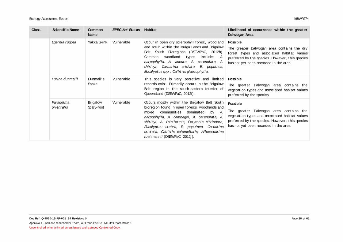
Class Scientific Name Common Name
EPBC Act Status Habitat Likelihood of occurrence within the greater Dalwogan Area
Egernia rugosa Yakka Skink Vulnerable Occur in open dry sclerophyll forest, woodland and scrub within the Mulga Lands and Brigalow Belt South Bioregions (DSEWPaC, 2012h). Common woodland types include: A. harpophylla, A. aneura, A. catenulata, A. shirleyi, Casuarina cristata, E. populnea, Eucalyptus spp., Callitris glaucophylla.
Possible
The greater Dalwogan area contains the dry forest types and associated habitat values preferred by the species. However, this species has not yet been recorded in the area
Furina dunmalli Dunmall’s Snake
Vulnerable This species is very secretive and limited records exist. Primarily occurs in the Brigalow Belt region in the south-eastern interior of Queensland (DSEWPaC, 2012i).
Possible
The greater Dalwogan area contains the vegetation types and associated habitat values preferred by the species.
Paradelma orientalis
Brigalow Scaly-foot
Vulnerable Occurs mostly within the Brigalow Belt South bioregion found in open forests, woodlands and mixed communities dominated by A. harpophylla, A. cambagei, A. catenulata, A. shirleyi, A. falciformis, Corymbia citriodora, Eucalyptus crebra, E. populnea, Casuarina cristata, Callitris columellaris, Allocasuarina luehmannii (DSEWPaC, 2012j).
Possible
The greater Dalwogan area contains the vegetation types and associated habitat values preferred by the species. However, this species has not yet been recorded in the area.

Ecology Assessment Report 46BWR274
Doc Ref: Q-4550-15-RP-001_34 Revision: 0 Page 29 of 61
Approvals, Land and Stakeholder Team, Australia Pacific LNG Upstream Phase 1
Uncontrolled when printed unless issued and stamped Controlled Copy.
4.1.1.4 Migratory and Marine Species
Based on a search of the EPBC Act Protected Matters Search Tool (Appendix A) and Birdata (BAA, 2012), 15 migratory bird species potentially occur within the Dalwogan area (Table 7).
It was considered that 6 species were likely to occur within the greater Dalwogan area and 8 other species were considered as possible occurrences. The remaining species were unlikely to occur, based on the known distribution of species and the availability of suitable habitat.
Ecology Assessment Report 46BWR274
Doc Ref: Q-4550-15-RP-001_34 Revision: 0 Page 30 of 61
Approvals, Land and Stakeholder Team, Australia Pacific LNG Upstream Phase 1
Uncontrolled when printed unless issued and stamped Controlled Copy.
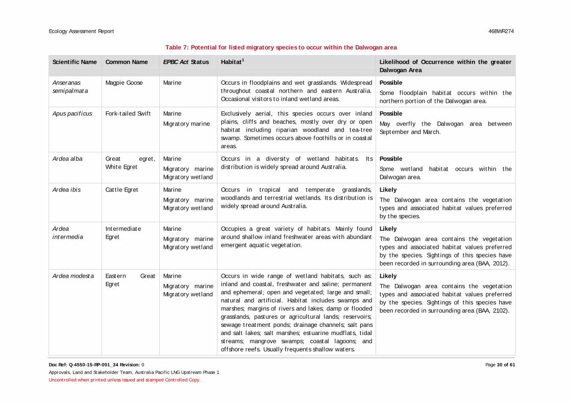
Table 7: Potential for listed migratory species to occur within the Dalwogan area
Scientific Name Common Name EPBC Act Status Habitat1 Likelihood of Occurrence within the greater Dalwogan Area
Anseranas semipalmata
Magpie Goose Marine Occurs in floodplains and wet grasslands. Widespread throughout coastal northern and eastern Australia. Occasional visitors to inland wetland areas.
Possible
Some floodplain habitat occurs within the northern portion of the Dalwogan area.
Apus pacificus Fork-tailed Swift Marine
Migratory marine
Exclusively aerial, this species occurs over inland plains, cliffs and beaches, mostly over dry or open habitat including riparian woodland and tea-tree swamp. Sometimes occurs above foothills or in coastal areas.
Possible
May overfly the Dalwogan area between September and March.
Ardea alba Great egret, White Egret
Marine
Migratory marine Migratory wetland
Occurs in a diversity of wetland habitats. Its distribution is widely spread around Australia.
Possible
Some wetland habitat occurs within the Dalwogan area.
Ardea ibis Cattle Egret Marine
Migratory marine Migratory wetland
Occurs in tropical and temperate grasslands, woodlands and terrestrial wetlands. Its distribution is widely spread around Australia.
Likely
The Dalwogan area contains the vegetation types and associated habitat values preferred by the species.
Ardea intermedia
Intermediate Egret
Marine
Migratory marine Migratory wetland
Occupies a great variety of habitats. Mainly found around shallow inland freshwater areas with abundant emergent aquatic vegetation.
Likely
The Dalwogan area contains the vegetation types and associated habitat values preferred by the species. Sightings of this species have been recorded in surrounding area (BAA, 2012).
Ardea modesta Eastern Great Egret
Marine
Migratory marine Migratory wetland
Occurs in wide range of wetland habitats, such as: inland and coastal, freshwater and saline; permanent and ephemeral; open and vegetated; large and small; natural and artificial. Habitat includes swamps and marshes; margins of rivers and lakes; damp or flooded grasslands, pastures or agricultural lands; reservoirs; sewage treatment ponds; drainage channels; salt pans and salt lakes; salt marshes; estuarine mudflats, tidal streams; mangrove swamps; coastal lagoons; and offshore reefs. Usually frequents shallow waters.
Likely
The Dalwogan area contains the vegetation types and associated habitat values preferred by the species. Sightings of this species have been recorded in surrounding area (BAA, 2102).
Ecology Assessment Report 46BWR274
Doc Ref: Q-4550-15-RP-001_34 Revision: 0 Page 31 of 61
Approvals, Land and Stakeholder Team, Australia Pacific LNG Upstream Phase 1
Uncontrolled when printed unless issued and stamped Controlled Copy.
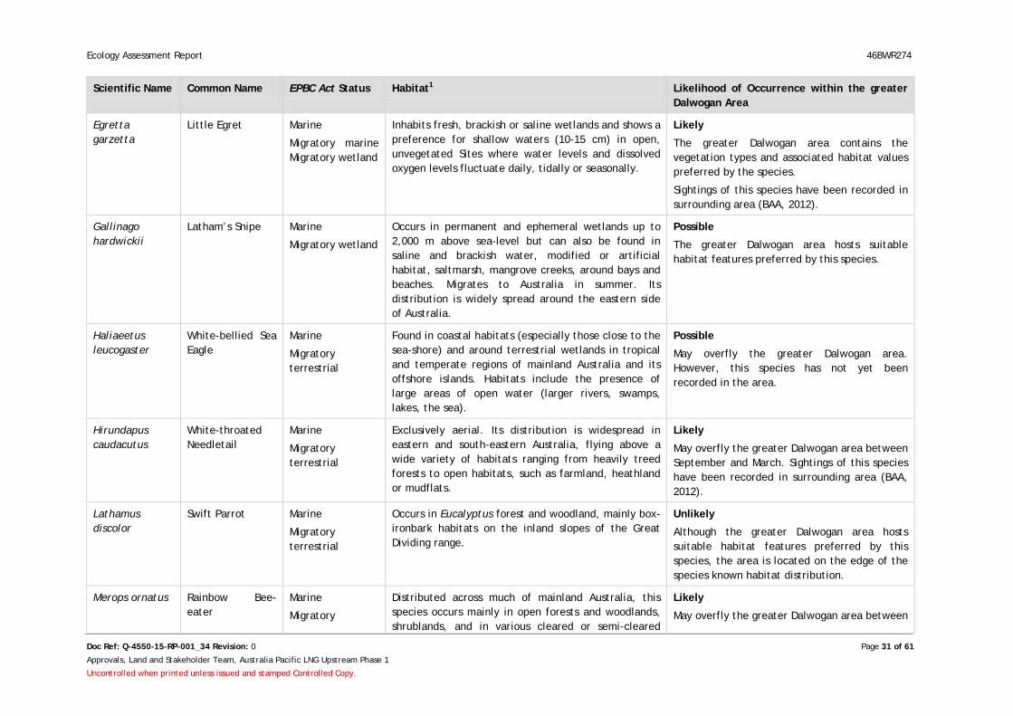
Scientific Name Common Name EPBC Act Status Habitat1 Likelihood of Occurrence within the greater Dalwogan Area
Egretta garzetta
Little Egret Marine
Migratory marine Migratory wetland
Inhabits fresh, brackish or saline wetlands and shows a preference for shallow waters (10-15 cm) in open, unvegetated Sites where water levels and dissolved oxygen levels fluctuate daily, tidally or seasonally.
Likely
The greater Dalwogan area contains the vegetation types and associated habitat values preferred by the species.
Sightings of this species have been recorded in surrounding area (BAA, 2012).
Gallinago hardwickii
Latham’s Snipe Marine
Migratory wetland
Occurs in permanent and ephemeral wetlands up to 2,000 m above sea-level but can also be found in saline and brackish water, modified or artificial habitat, saltmarsh, mangrove creeks, around bays and beaches. Migrates to Australia in summer. Its distribution is widely spread around the eastern side of Australia.
Possible
The greater Dalwogan area hosts suitable habitat features preferred by this species.
Haliaeetus leucogaster
White-bellied Sea Eagle
Marine
Migratory terrestrial
Found in coastal habitats (especially those close to the sea-shore) and around terrestrial wetlands in tropical and temperate regions of mainland Australia and its offshore islands. Habitats include the presence of large areas of open water (larger rivers, swamps, lakes, the sea).
Possible
May overfly the greater Dalwogan area. However, this species has not yet been recorded in the area.
Hirundapus caudacutus
White-throated Needletail
Marine
Migratory terrestrial
Exclusively aerial. Its distribution is widespread in eastern and south-eastern Australia, flying above a wide variety of habitats ranging from heavily treed forests to open habitats, such as farmland, heathland or mudflats.
Likely
May overfly the greater Dalwogan area between September and March. Sightings of this species have been recorded in surrounding area (BAA, 2012).
Lathamus discolor
Swift Parrot Marine
Migratory terrestrial
Occurs in Eucalyptus forest and woodland, mainly box-ironbark habitats on the inland slopes of the Great Dividing range.
Unlikely
Although the greater Dalwogan area hosts suitable habitat features preferred by this species, the area is located on the edge of the species known habitat distribution.
Merops ornatus Rainbow Bee-eater
Marine
Migratory
Distributed across much of mainland Australia, this species occurs mainly in open forests and woodlands, shrublands, and in various cleared or semi-cleared
Likely
May overfly the greater Dalwogan area between
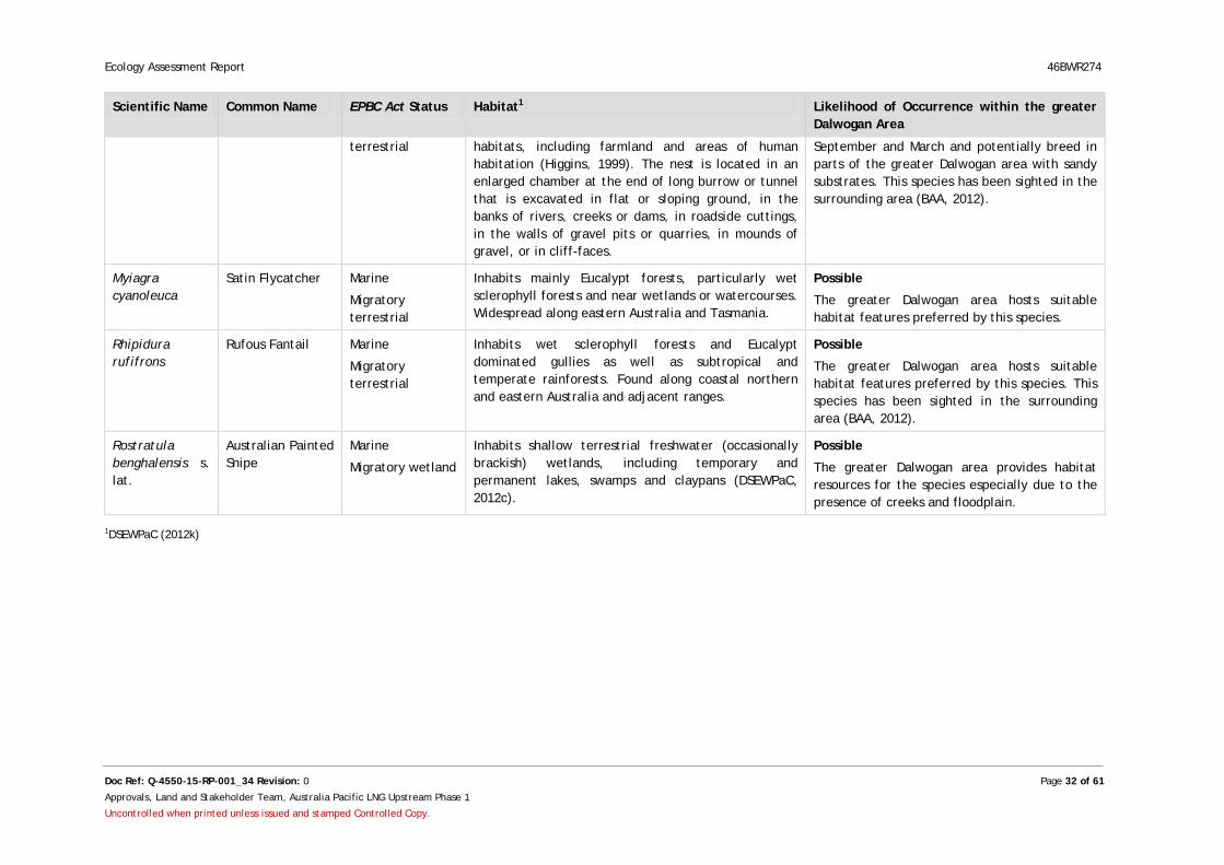
Ecology Assessment Report 46BWR274
Doc Ref: Q-4550-15-RP-001_34 Revision: 0 Page 32 of 61
Approvals, Land and Stakeholder Team, Australia Pacific LNG Upstream Phase 1
Uncontrolled when printed unless issued and stamped Controlled Copy.
Scientific Name Common Name EPBC Act Status Habitat1 Likelihood of Occurrence within the greater Dalwogan Area
terrestrial habitats, including farmland and areas of human habitation (Higgins, 1999). The nest is located in an enlarged chamber at the end of long burrow or tunnel that is excavated in flat or sloping ground, in the banks of rivers, creeks or dams, in roadside cuttings, in the walls of gravel pits or quarries, in mounds of gravel, or in cliff-faces.
September and March and potentially breed in parts of the greater Dalwogan area with sandy substrates. This species has been sighted in the surrounding area (BAA, 2012).
Myiagra cyanoleuca
Satin Flycatcher Marine
Migratory terrestrial
Inhabits mainly Eucalypt forests, particularly wet sclerophyll forests and near wetlands or watercourses. Widespread along eastern Australia and Tasmania.
Possible
The greater Dalwogan area hosts suitable habitat features preferred by this species.
Rhipidura rufifrons
Rufous Fantail Marine
Migratory terrestrial
Inhabits wet sclerophyll forests and Eucalypt dominated gullies as well as subtropical and temperate rainforests. Found along coastal northern and eastern Australia and adjacent ranges.
Possible
The greater Dalwogan area hosts suitable habitat features preferred by this species. This species has been sighted in the surrounding area (BAA, 2012).
Rostratula benghalensis s. lat.
Australian Painted Snipe
Marine
Migratory wetland
Inhabits shallow terrestrial freshwater (occasionally brackish) wetlands, including temporary and permanent lakes, swamps and claypans (DSEWPaC, 2012c).
Possible
The greater Dalwogan area provides habitat resources for the species especially due to the presence of creeks and floodplain.
1DSEWPaC (2012k)
Ecology Assessment Report 46BWR274
Doc Ref: Revision: Q-4550-15-RP-001_34 Rev: 0 Page 33 of 61
Approvals, Land and Stakeholder Team, Australia Pacific LNG Upstream Phase 1
Uncontrolled when printed unless issued and stamped Controlled Copy.
4.1.1.5 Weeds
Based on the EPBC Act Protected Matters Search Tool results (Appendix A), 4 weeds of national significance (WoNS) occurred or could potentially occur within the Dalwogan area (Table 8). All 4 species of weeds could possibly occur within the Dalwogan area as it lies within their known species range.
Table 8: Potential for Weeds of National Significance to occur within the Dalwogan area
Scientific Name Common Name Likelihood of Occurrence within the greater Dalwogan Area
Hymenachne amplexicaulis Hymenachne Possible
Parkinsonia aculeata Parkinsonia Possible
Parthenium hysterophorus Parthenium Weed Possible
Salvinia molesta Salvinia Possible
4.1.1.6 Pest Fauna
According to the EPBC Act Protected Matters Search Tool results (Appendix A), 5 species of pest fauna occurred or could potentially occur in the Dalwogan area (Table 9). Their likelihood of occurrence was based on the known distribution of species and the availability of suitable habitat within the Dalwogan area. 4 of these species are classified as declared class 2 pest animals under the LP Act.
Table 9: Potential for pest fauna species to occur within the Dalwogan area
Scientific Name Common Name Classification Under LP Act
Likelihood of occurrence within the greater Dalwogan Area
Rhinella marinus Cane toad N/A Likely
Felis catus Feral cat Class 2 Likely
Oryctolagus cuniculus European rabbit Class 2 Likely
Sus scrofa Pig Class 2 Likely
Vulpes vulpes Red fox Class 2 Likely
4.1.2 Wetland of International Importance
One wetland of international significance was identified during desktop analysis (DSEWPaC, 2013 and Appendix A) - the Narran Lake nature reserve which is listed as a Ramsar Site. As the greater Dalwogan area is located approximately 550 km away from this wetland, in a different catchment area, it is not expected that this wetland would be impacted by the proposed project.
4.1.3 Nature Conservation Act
NC Reg-listed species that could potentially occur in the Dalwogan area are summarised in Section 4.1.3. A copy of the Wildlife Online database search report is presented in Appendix B.
4.1.3.1 Listed Flora
The NC Reg Wildlife Online database (DEHP, 2013 and Appendix B) and HERBRECS database (Queensland Herbarium, 2012) identified two threatened flora species as occurring within the vicinity of the Dalwogan area (Table 10). Based on the RE vegetation descriptions in the Dalwogan area (Section 4.1.6), these species were considered to possibly occur due to the presence of suitable habitat.
Ecology Assessment Report 46BWR274
Doc Ref: Q-4550-15-RP-001_34 Revision: 0 Page 34 of 61
Approvals, Land and Stakeholder Team, Australia Pacific LNG Upstream Phase 1
Uncontrolled when printed unless issued and stamped Controlled Copy.
Table 10: NC Reg-listed flora species with the potential to occur within the Dalwogan area
Class Scientific Name
Common Name
NC Reg Status
Habitat Likelihood of Occurrence within greater Dalwogan Area
Higher Dicots Micromyrtus carinata
Gurulmundi Heath-Myrtle
Endangered Previously recorded in shrubland vegetation dominated by Hakea spp., Micromyrtus spp., and associated with RE 11.7.5.
Possible
Preferred vegetation communities occur within the greater Dalwogan area.
Higher Dicots Rutidosis lanata
Wrinklewort Endangered Previously recorded in low Eucalyptus woodland vegetation dominated by associated with RE 11.7.7. Also found in grey loamy substrate with some gravel. Adjoins clay plain with cleared Acacia harpophylla/ Casuarina cristata.
Possible
Preferred vegetation communities occur within the greater Dalwogan area.
4.1.3.2 Listed Fauna
Based on a search of the NC Reg Wildlife Online database (DEHP, 2013) and Birdata (BAA, 2012), three threatened fauna species under the NC Reg were identified as occurring within the vicinity of the Dalwogan area. These species are presented in Table 11 and were considered possibilities of occurring within the Dalwogan area based on the availability of suitable habitat. These species were also considered possible to occur at the Site.

Ecology Assessment Report 46BWR274
Doc Ref: Revision: Q-4550-15-RP-001_34 Rev: 0 Page 35 of 61
Approvals, Land and Stakeholder Team, Australia Pacific LNG Upstream Phase 1
Uncontrolled when printed unless issued and stamped Controlled Copy.
Table 11: NC Reg-listed fauna species with the potential to occur within the Dalwogan area
Class Scientific Name Common Name
NC Reg Status Habitat Likelihood of Occurrence Within the Dalwogan Area
Bird Calyptorhynchus lathami
Glossy Black-Cockatoo
Vulnerable Occurs within southern Queensland, usually feeding in remnant Belah (Casuarina cristata) and Bull Oak (Allocasuarina luehmannii) forests (Glossy Black Conservancy, 2010).
Likely
The Dalwogan area contains suitable habitat for this species and sightings have occurred in the area.
Lophoictinia isura Square-tailed Kite
Near Threatened
Forages over coastal and sub-coastal Eucalypt-dominated open forests and woodlands, and inland riparian woodland. Particularly favours: productive forests on the coastal plain, box-ironbark-gum woodlands on the inland slopes, and Coolibah/River-Red-Gum on the inland plains (Marchant & Higgins 1993).
Likely
The Dalwogan area contains suitable habitat for this species and sightings have occurred in the area.
Melithreptus gularis
Black-chinned Honeyeater
Near Threatened
Occurs in the upper levels of open Eucalypt forests and woodlands dominated by box and ironbark Eucalypts. It is often found along waterways, especially in arid and semi-arid areas and in northern Australia (Marchant & Higgins, 1993).
Likely
The Dalwogan area contains suitable habitat for this species and sightings have occurred in the area.

Ecology Assessment Report 46BWR274
Doc Ref: Q-4550-15-RP-001_34 Revision: 0 Page 36 of 61
Approvals, Land and Stakeholder Team, Australia Pacific LNG Upstream Phase 1
Uncontrolled when printed unless issued and stamped Controlled Copy.
4.1.4 Environmentally Sensitive Areas
ESAs mapped by DEHP as occurring within the greater Dalwogan area comprise Endangered REs (Category B ESA) (Appendix C).
4.1.5 Referable Wetlands
DEHP Referable Wetlands mapping (DEHP, 2012e) identified no referable wetlands to occur within the Site.
4.1.6 Regional Ecosystems
A search of the DEHP RE mapping was undertaken on 16 April 2012. A detailed map of REs (Biodiversity status) occurring on the Site is provided in Figure 3. These REs are described below.
4.1.6.1 Endangered Regional Ecosystems
No Endangered REs were identified as occurring on the Site during the desktop analysis (DEHP, 2013a) (Figure 3).
4.1.6.2 Of Concern Regional Ecosystems
One Of Concern RE was identified as occurring within the Site (DEHP, 2013a), as presented in Figure 3. Its vegetation description is summarised below (Table 12).
Table 12: Of Concern Regional Ecosystems mapped as being present within the Site
RE Code General Description Description
11.3.25 Eucalyptus tereticornis or E. camaldulensis woodland fringing drainage lines
Eucalyptus camaldulensis or E. tereticornis open-forest to woodland. Other tree species such as: Casuarina cunninghamiana, E. coolabah, Melaleuca bracteata, Melaleuca viminalis, Livistona spp. (in north), Melaleuca spp. and Angophora floribunda are commonly present and may be locally dominant. An open to sparse, tall shrub layer is frequently present dominated by species including: Acacia salicina, A. stenophylla or Lysiphyllum carronii. Low shrubs are present but rarely form a conspicuous layer. The ground layer is open to sparse and dominated by perennial grasses, sedges or forbs such as: Imperata cylindrica, Bothriochloa bladhii, B. ewartiana, Chrysopogon fallax, Cyperus dactylotes, C. difformis, C. exaltatus, C. gracilis, C. iria, C. rigidellus, C. victoriensis, Dichanthium sericeum, Leptochloa digitata, Lomandra longifolia or Panicum spp. Occurs on fringing levees and banks of major rivers and drainage lines of alluvial plains throughout the region. Soils are very deep, alluvial, grey and brown cracking clays with or without some texture contrast. These are usually moderately deep to deep, soft or firm, acid, neutral or alkaline brown sands, loams or black cracking or non-cracking clays, and may be sodic at depth.
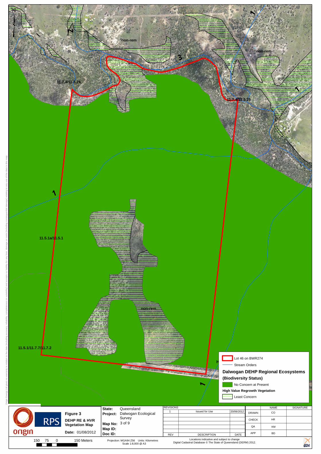
11.5.1a/11.5.1
non-rem
non-rem
non-rem
11.7.4/11.3.25
11.5.1/11.7.7/11.7.2
11.7.4/11.3.25
11.5.1/11.7.7/11.7.2
11.5.1/11.7.7/11.7.2
3
1
2
1
1
1
X-XXXX-XX-XX-XXXX
3 of 9
Dalwogan EcologicalSurvey
Queensland
Orig
in E
nerg
y Lt
d gi
ves
no w
arra
nty
in r
elat
ion
to th
e da
ta (
incl
udin
g ac
cura
cy, r
elia
bilit
y, c
ompl
eten
ess
or s
uita
bilit
y) a
nd a
ccep
ts n
o lia
bilit
y fo
r any
loss
, dam
age
or c
osts
(in
clud
ing
cons
eque
ntia
l dam
age)
rel
atin
g to
any
use
of t
he d
ata
in th
is m
ap.
State:
Map No:Map ID: Doc ID:
Project:REVISIONS
REV DESCRIPTION DATE
1 Issued for UseNAME SIGNATURE
DRAWN
CHECK
QA
APP
Projection: MGA94 Z56 Units: Kilometres Scale 1:8,000 @ A3
Locations indicative and subject to changeDigital Cadastral Database © The State of Queensland (DERM) 2012.
20/06/2012 CO
KM
HR
BD
³
150 0 15075 Meters
High Value Regrowth Vegetation
Figure 3DEHP RE & HVR Vegetation MapDate: 01/08/2012
Lot 46 on BWR274
Stream Orders
Dalwogan DEHP Regional Ecosystems(Biodiversity Status)
No Concern at Present
High Value Regrowth VegetationLeast Concern

Ecology Assessment Report 46BWR274
Doc Ref: Q-4550-15-RP-001_34 Revision: 0 Page 38 of 61
Approvals, Land and Stakeholder Team, Australia Pacific LNG Upstream Phase 1
Uncontrolled when printed unless issued and stamped Controlled Copy.
4.1.6.3 No Concern at Present Regional Ecosystems
All No Concern at Present REs identified as occurring within the Site during the desktop analysis(DEHP, 2013a) are presented in Figure 3 and their vegetation descriptions are summarised below (Table 13).
Table 13: No Concern at Present Regional Ecosystems mapped as being present within the Site
RE Code General Description Description
11.5.1 Eucalyptus crebra, Callitris glaucophylla Angophora leiocarpa, Allocasuarina luehmannii woodland on Cainozoic sandplains/remnant surfaces
Eucalyptus crebra and/or E. populnea +/- Angophora leiocarpa+/- E. woollsiana (in south of bioregion) dominate the woodland (to open-woodland) canopy. A low tree layer dominated by Allocasuarina luehmannii +/- Melaleuca decora +/- Callitris glaucophylla +/- C. endlicheri is usually present. In some areas Allocasuarina luehmannii low woodland is the dominant layer. The ground cover is usually sparse and dominated by perennial grasses. Occurs on Cainozoic sandplains, especially outwash from weathered sandstones. Duplex soils with sandy surfaces. Major vegetation communities include:
11.5.1a: Eucalyptus populnea woodland with Allocasuarina luehmannii low tree layer.
11.7.2 Acacia spp. woodland on lateritic duricrust. Scarp retreat zone
Monospecific stands of Acacia spp. forest/woodland on Cainozoic lateritic duricrusts. Acacia shirleyi and or Acacia catenulata usually predominate the woodland to low woodland to low open-forest tree canopy (7-12m high). Other Acacia spp. that commonly occur and occasionally dominate the tree layer include A. rhodoxylon, A. burrowii, A. sparsiflora, A. crassa and A. blakei. Emergent Eucalypt species such as Eucalyptus thozetiana, E. crebra, E. decorticans and E. exserta may be present. A low shrub layer is sometimes present and dominated by species such as Acalypha eremorum, Croton phebalioides and Carissa ovata. The ground layer is extremely sparse and dominated by grasses such as Aristida caput-medusae, Paspalidium rarum, Urochloa foliosa. Forbs are usually rare although Sida filiformis may be conspicuous. Occurs on scarps and adjacent tops and slopes of dissected tablelands, mesas and buttes formed from chemically altered sediments and duricrusts. The soils are shallow to very shallow lithosols with surface stone and boulders. The vegetation is often growing in pockets of shallow lithosol soil between bare rock.
11.7.4 Eucalyptus decorticans and/or Eucalyptus spp., Corymbia spp., Acacia spp., Lysicarpus angustifolius on lateritic duricrust
Mixed Eucalyptus spp. woodland on Cainozoic lateritic duricrusts. Species can include Eucalyptus crebra, E. decorticans, Corymbia trachyphloia, E. tenuipes, C. watsoniana and Callitris glaucophylla. There is usually a distinct low tree to tall shrub layer comprising species including Lysicarpus angustifolius or Acacia spp. Occurs on low hills and ranges with shallow soils.

Ecology Assessment Report 46BWR274
Doc Ref: Q-4550-15-RP-001_34 Revision: 0 Page 39 of 61
Approvals, Land and Stakeholder Team, Australia Pacific LNG Upstream Phase 1
Uncontrolled when printed unless issued and stamped Controlled Copy.
RE Code General Description Description
11.7.7 Eucalyptus fibrosa
subsp. nubila +/- Corymbia spp. +/- Eucalyptus spp. on lateritic duricrust
Eucalyptus fibrosa subsp. nubila predominates and forms a distinct but discontinuous open-forest to woodland canopy (22-25m high). E. crebra often co-dominates or be locally dominant, particularly on lower slopes. Also includes areas with Corymbia citriodora as a co-dominant. Other frequently occurring sub-dominant tree species include Corymbia trachyphloia, E. apothalassica, E. sideroxylon, Acacia shirleyi and Callitris glaucophylla. There is usually a low woodland mid layer dominated by Acacia spp. or sometimes Allocasuarina luehmannii and Callitris endlicheri. Scattered tall shrubs may occur, but rarely form a prominent layer. There is usually a moderately dense, low shrub layer developed with a variable floristic composition. The ground layer is open to moderately dense and dominated by grasses. Occurs on low hills and ranges formed from deeply weathered sediments. Soils are usually shallow (< 30cm deep) uniform sands with stone or rocks covering much of the ground surface.
4.1.6.4 High Value Regrowth
A search of the DEHP Regrowth Vegetation map (DEHP, 2012a) was undertaken on 16 April 2012. A detailed map of HVR occurring on the Site is provided in Figure 3.
One type of HVR vegetation was identified as occurring in the northern section of the Site (Figure 3 and Table 14).
Table 14: HVR mapped as being present within the Site
HVR Code General Description
HVR containing Least Concern REs Woody regrowth >15yrs old
4.1.6.5 Essential Habitat
DEHP Essential Habitat mapping (DEHP, 2012c) identified that no Essential Habitat occurred within the Site.
4.2 Field Survey The field survey for the Site was undertaken on 18th July 2012 by three RPS ecologists. Sites targeted for survey are presented in Figure 2 and field results are summarised in the following sections.
4.2.1 Matters of National Environmental Significance
4.2.1.1 Threatened Ecological Communities
One TEC was identified as occurring within the Site, namely the Brigalow (Acacia harpophylla dominant and co-dominant) TEC. In Queensland, the Brigalow TEC is analogous to 16 REs, all of which are listed as Endangered under the VM Act. The field survey confirmed the presence of HVR containing Endangered RE in the southern section of the Site. This regrowth vegetation was consistent with RE 11.5.16, A. harpophylla and/or Casuarina cristata open forest in depressions on Cainozoic sand plains/remnant surfaces.
The ground-truthed extent of the Brigalow TEC is presented in Figure 4.
4.2.1.2 Listed Flora
No EPBC Act protected flora species were identified during field investigations. However, two species are considered possibilities of occurring at the Site due to the presence of suitable habitat (Table 15).
All flora species identified within the Site during the field survey are listed in Appendix D.

Ecology Assessment Report 46BWR274
Doc Ref: Q-4550-15-RP-001_34 Revision: 0 Page 40 of 61
Approvals, Land and Stakeholder Team, Australia Pacific LNG Upstream Phase 1
Uncontrolled when printed unless issued and stamped Controlled Copy.
Table 15: EPBC Act-protected flora species with potential to occur within the Site
Scientific Name Common Name EPBC Act Status
Likelihood of Occurrence at the Site
Cadellia pentastylis Ooline Vulnerable Possible due to the presence of HVR containing Endangered RE (consistent with RE 11.5.16).
Homopholis belsonii Belson’s Panic Vulnerable Possible due to the presence of HVR containing Endangered RE (consistent with RE 11.5.16)
4.2.1.3 Listed Fauna
No fauna species listed as threatened under the EPBC Act were detected during the field survey. However, potential habitat was identified within the Site for the species listed in Table 16.
All fauna species identified within the Site during the field survey are listed in Appendix D.

3
1
2 1
1
1
X-XXXX-XX-XX-XXXX
Dalwogan EcologicalSurvey
Queensland
Orig
in E
nerg
y Lt
d gi
ves
no w
arra
nty
in r
elat
ion
to th
e da
ta (
incl
udin
g ac
cura
cy, r
elia
bilit
y, c
ompl
eten
ess
or s
uita
bilit
y) a
nd a
ccep
ts n
o lia
bilit
y fo
r any
loss
, dam
age
or c
osts
(in
clud
ing
cons
eque
ntia
l dam
age)
rel
atin
g to
any
use
of t
he d
ata
in th
is m
ap.
State:
Map No:Map ID: Doc ID:
Project:REVISIONS
REV DESCRIPTION DATE
1 Issued for Use
4 of 9
NAME SIGNATURE
DRAWN
CHECK
QA
APP
Projection: MGA94 Z56 Units: Kilometres Scale 1:8,000 @ A3
Locations indicative and subject to changeDigital Cadastral Database © The State of Queensland (DERM) 2012.
01/08/2012 CO
KM
HR
BD
³
150 0 15075 Meters
Figure 4
Date:
Ground-truthed TECs map
01/08/2012
Lot 46 on BWR274
Stream Orders
Threatened Ecological CommunityAcacia harpophylla and/or Casuarina cristata open forest on alluvial plains

Ecology Assessment Report 46BWR274
Doc Ref: Q-4550-15-RP-001_34 Revision: 0 Page 42 of 61
Approvals, Land and Stakeholder Team, Australia Pacific LNG Upstream Phase 1
Uncontrolled when printed unless issued and stamped Controlled Copy.
Table 16: EPBC Act-protected fauna species with potential to occur within the Site
Class Scientific Name Common Name EPBC Act Status
Likelihood of Occurrence at the Site
Birds Erythrotriorchis radiatus
Red Goshawk Vulnerable Possible
Suitable habitat in the form of Eucalypt woodland occurs within the Site.
Geophaps scripta scripta
Squatter Pigeon (southern)
Vulnerable Likely
Suitable habitat for this species includes grassy understoreys and cleared areas.
Mammals Chalinolobus dwyeri
Large-eared Pied Bat, Large Pied Bat
Vulnerable Possible
Suitable habitat for this species includes forested areas.
Nyctophilus corbeni (South-eastern form)
South-eastern Long-eared Bat
Vulnerable Possible
Species with the genus Nyctophilus were positively identified from Anabat call data. However, the species could not be reliably identified due to similarities between their calls and those other species. Suitable habitat features identified (e.g. hollow trees within remnant vegetation).
Phascolarctos cinereus
Koala Vulnerable Possible
Presence of suitable feed trees (e.g. Eucalyptus spp., Corymbia spp.).
Reptiles Delma torquata Collared Delma Vulnerable Possible
Presence of suitable habitat, including rocky areas and Eucalyptus woodlands with deep leaf litter.
Denisonia maculata Ornamental Snake Vulnerable Possible
Some suitable habitat features identified (e.g. Eucalypt woodlands adjacent to wetlands).
Egernia rugosa Yakka Skink Vulnerable Possible
Presence of suitable habitat including dry Eucalyptus woodlands.
Furina dunmalli Dunmall’s Snake Vulnerable Possible
Some suitable habitat features identified (e.g. logs and leaf litter in remnant vegetation).
Paradelma orientalis
Brigalow Scaly-foot Vulnerable Possible
Presence of suitable habitat including Eucalyptus woodlands.

Ecology Assessment Report 46BWR274
Doc Ref: Q-4550-15-RP-001_34 Revision: 0 Page 43 of 61
Approvals, Land and Stakeholder Team, Australia Pacific LNG Upstream Phase 1
Uncontrolled when printed unless issued and stamped Controlled Copy.
4.2.1.4 Migratory Species
No fauna species listed as migratory under the EPBC Act were detected on Site during the field survey. However, suitable habitat was confirmed for the species listed in Table 17.
Table 17: EPBC Act-protected Migratory Fauna species with potential to occur within the Site
Scientific Name Common Name EPBC Act Status Likelihood of Occurrence at the Site
Apus pacificus Fork-tailed swift Marine
Migratory marine
Possible
May fly over the Site between September and March
Ardea alba Great egret, white egret Marine
Migratory marine Migratory wetland
Possible
Some aquatic habitat present.
Ardea ibis Cattle egret Marine
Migratory marine Migratory wetland
Possible
Habitat is present within cleared areas and woodlands. However, this species is generally uncommon around Miles.
Ardea intermedia Intermediate Egret Marine
Migratory marine Migratory wetland
Possible
Some aquatic habitat present. Species has also been recorded in the surrounding area.
Ardea modesta Eastern Great Egret Marine
Migratory marine Migratory wetland
Likely
Some aquatic habitat present. Species has also been recorded in the surrounding area.
Egretta garzetta Little Egret Marine
Migratory marine Migratory wetland
Likely
Some aquatic habitat present. Species has also been recorded in the surrounding area.
Haliaeetus leucogaster
White-bellied sea eagle Marine
Migratory terrestrial
Possible
May fly over the Site.
Hirundapus caudacutus
White-throated needletail Marine
Migratory terrestrial
Likely
May fly over the Site between September and March. Species has been recorded in the surrounding area.
Lathamus discolor Swift parrot Marine
Migratory terrestrial
Possible
Presence of suitable habitat including Eucalyptus woodlands.
Merops ornatus Rainbow bee-eater Marine
Migratory terrestrial
Likely
Presence of suitable habitat and species has been recorded in the surrounding area.
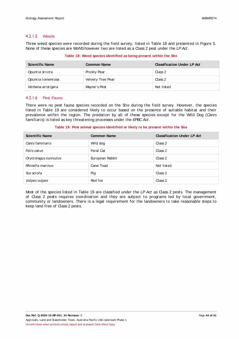
Ecology Assessment Report 46BWR274
Doc Ref: Q-4550-15-RP-001_34 Revision: 0 Page 44 of 61
Approvals, Land and Stakeholder Team, Australia Pacific LNG Upstream Phase 1
Uncontrolled when printed unless issued and stamped Controlled Copy.
4.2.1.5 Weeds
Three weed species were recorded during the field survey, listed in Table 18 and presented in Figure 5. None of these species are WoNS however two are listed as a Class 2 pest under the LP Act.
Table 18: Weed species identified as being present within the Site
Scientific Name Common Name Classification Under LP Act
Opuntia stricta Prickly Pear Class 2
Opuntia tomentosa Velvety Tree Pear Class 2
Verbena aristigera Mayne’s Pest Not listed
4.2.1.6 Pest Fauna
There were no pest fauna species recorded on the Site during the field survey. However, the species listed in Table 19 are considered likely to occur based on the presence of suitable habitat and their prevalence within the region. The predation by all of these species except for the Wild Dog (Canis familiaris) is listed as key threatening processes under the EPBC Act.
Table 19: Pest animal species identified or likely to be present within the Site
Scientific Name Common Name Classification Under LP Act
Canis familiaris Wild dog Class 2
Felis catus Feral Cat Class 2
Oryctolagus cuniculus European Rabbit Class 2
Rhinella marinus Cane Toad Not listed
Sus scrofa Pig Class 2
Vulpes vulpes Red fox Class 2
Most of the species listed in Table 19 are classified under the LP Act as Class 2 pests. The management of Class 2 pests requires coordination and they are subject to programs led by local government, community or landowners. There is a legal requirement for the landowners to take reasonable steps to keep land free of Class 2 pests.
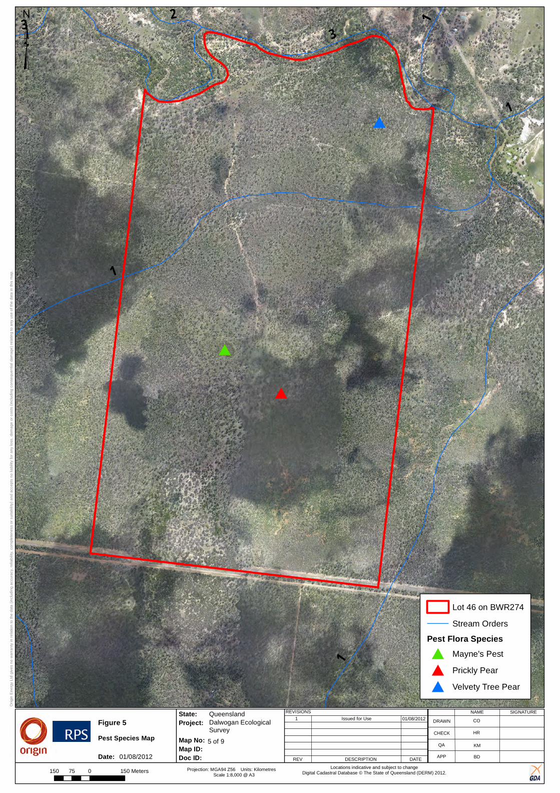
X-XXXX-XX-XX-XXXX
Dalwogan EcologicalSurvey
Queensland
Orig
in E
nerg
y Lt
d gi
ves
no w
arra
nty
in r
elat
ion
to th
e da
ta (
incl
udin
g ac
cura
cy, r
elia
bilit
y, c
ompl
eten
ess
or s
uita
bilit
y) a
nd a
ccep
ts n
o lia
bilit
y fo
r any
loss
, dam
age
or c
osts
(in
clud
ing
cons
eque
ntia
l dam
age)
rel
atin
g to
any
use
of t
he d
ata
in th
is m
ap.
State:
Map No:Map ID: Doc ID:
Project:REVISIONS
REV DESCRIPTION DATE
1 Issued for Use
5 of 9
NAME SIGNATURE
DRAWN
CHECK
QA
APP
Projection: MGA94 Z56 Units: Kilometres Scale 1:8,000 @ A3
Locations indicative and subject to changeDigital Cadastral Database © The State of Queensland (DERM) 2012.
#
##
#
3
1
2
1
13
1
01/08/2012 CO
KM
HR
BD
Lot 46 on BWR274
Stream Orders
Pest Flora Species# Mayne's Pest
# Prickly Pear
# Velvety Tree Pear
150 0 15075 Meters
³
Figure 5Pest Species Map
Date: 01/08/2012
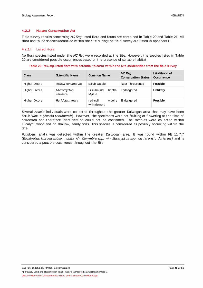
Ecology Assessment Report 46BWR274
Doc Ref: Q-4550-15-RP-001_34 Revision: 0 Page 46 of 61
Approvals, Land and Stakeholder Team, Australia Pacific LNG Upstream Phase 1
Uncontrolled when printed unless issued and stamped Controlled Copy.
4.2.2 Nature Conservation Act
Field survey results concerning NC Reg listed flora and fauna are contained in Table 20 and Table 21. All flora and fauna species identified within the Site during the field survey are listed in Appendix D.
4.2.2.1 Listed Flora
No flora species listed under the NC Reg were recorded at the Site. However, the species listed in Table 20 are considered possible occurrences based on the presence of suitable habitat.
Table 20: NC Reg-listed flora with potential to occur within the Site as identified from the field survey
Class Scientific Name Common Name NC Reg Conservation Status
Likelihood of Occurrence
Higher Dicots Acacia tenuinervis scrub wattle Near Threatened Possible
Higher Dicots Micromyrtus carinata
Gurulmundi heath-Myrtle
Endangered Unlikely
Higher Dicots Rutidosis lanata red-soil woolly wrinklewort
Endangered Possible
Several Acacia individuals were collected throughout the greater Dalwogan area that may have been Scrub Wattle (Acacia tenuinervis). However, the specimens were not fruiting or flowering at the time of collection and therefore identification could not be confirmed. The samples were collected within Eucalypt woodland on shallow, sandy soils. This species is considered as possibly occurring within the Site.
Rutidosis lanata was detected within the greater Dalwogan area. It was found within RE 11.7.7 (Eucalyptus fibrosa subsp. nubila +/- Corymbia spp. +/- Eucalyptus spp. on lateritic duricrust) and is considered a possible occurrence throughout the Site.

Ecology Assessment Report 46BWR274
Doc Ref: Q-4550-15-RP-001_34 Revision: 0 Page 47 of 61
Approvals, Land and Stakeholder Team, Australia Pacific LNG Upstream Phase 1
Uncontrolled when printed unless issued and stamped Controlled Copy.
4.2.2.2 Listed Fauna
No fauna species listed under the NC Reg were recorded within the Site. However, three threatened fauna species are considered likely to occur based on the presence of suitable habitat. These species are presented in Table 21.
Table 21: NC Reg-listed fauna with potential to occur within the Site as identified from field survey
Scientific Name Common Name
NC Reg Status
Habitat Likelihood of Occurrence
Calyptorhynchus lathami
Glossy Black Cockatoo
Vulnerable Within southern Queensland, usually feed in remnant Belah (Casuarina cristata) and Bull Oak (Allocasuarina luehmannii) forests (Glossy Black Conservancy, 2010).
Possible
Preferred habitat present on Site. The presence of this species was confirmed on adjacent properties.
Chalinolobus picatus
Little Pied Bat Near Threatened
This species occurs in Eucalypt and acacia-dominated open woodlands, semi-arid tall scrublands, dry sclerophyll forests, and Araucarian notophyll vine forests. It is found in subterranean roosts, tree hollows, and abandoned buildings (IUCN Red List 2012).
Possible
This species was positively identified from Anabat call data on adjacent properties. Suitable habitat features exist within the Site (e.g. hollow trees within remnant vegetation).
Strophurus taenicauda
Golden-tailed Gecko
Near Threatened
Occurs within open woodland and open forest where it shelters under loose bark and hollow limbs (DEHP, 2010).
Possible
Preferred habitat is present on the Site and this species was recorded on adjacent properties.
Several individual Glossy Black Cockatoos (Calyptorhynchus lathami) were observed feeding within or flying over Allocasuarina inophloia open woodland. This species is listed as Vulnerable under the NC Reg. Potential habitat for this species includes all remnant and regrowth woodland containing Allocasuarina spp. at the Site.
Two individual Golden-tailed Geckos (Strophurus taenicauda) were found in regrowth vegetation containing Bull Oak (Allocasuarina luehmannii) on nearby Lots. They were found under the bark of dead Bull Oak stags, all of which were relatively small (Diameter at Breast Height [DBH] < 100 mm). Potential habitat for this species includes all remnant and regrowth vegetation containing trees with loose bark.
Little Pied Bat (Chalinolobus picatus) was positively identified from Anabat call data on adjacent properties.
4.2.2.3 Other Significant Flora and Fauna
A number of Type A restricted plants were identified within the greater Dalwogan area, including Grass Trees (Xanthorrhoea johnsonii), Black Orchids (Cymbidium canaliculatum) and a number of species in the genus Brachychiton.
One Type A plant was identified within the southern portion of the Site during the field survey, Blue Caladenia (Caladenia caerulea) (Figure 6).
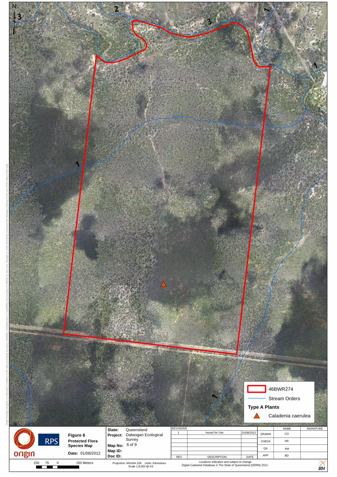
X-XXXX-XX-XX-XXXX
Dalwogan EcologicalSurvey
Queensland
Orig
in E
nerg
y Lt
d gi
ves
no w
arra
nty
in re
latio
n to
the
data
(inc
ludi
ng a
ccur
acy,
relia
bilit
y, c
ompl
eten
ess
or s
uita
bilit
y) a
nd a
ccep
ts n
o lia
bilit
y fo
r any
loss
, dam
age
or c
osts
(inc
ludi
ng c
onse
quen
tial d
amag
e) re
latin
g to
any
use
of t
he d
ata
in th
is m
ap.
State:
Map No:Map ID: Doc ID:
Project:REVISIONS
REV DESCRIPTION DATE
1 Issued for Use
6 of 9
NAME SIGNATURE
DRAWN
CHECK
QA
APP
Projection: MGA94 Z56 Units: Kilometres Scale 1:8,000 @ A3
Locations indicative and subject to changeDigital Cadastral Database © The State of Queensland (DERM) 2012.
#*
1
32 1
1
1
3
01/08/2012 CO
KM
HR
BD
150 0 15075 Meters
46BWR274
Stream Orders
Type A Plants#* Caladenia caerulea
³
Figure 6
Date:
Protected Flora Species Map
01/08/2012

Ecology Assessment Report 46BWR274
Doc Ref: Q-4550-15-RP-001_34 Revision: 0 Page 49 of 61
Approvals, Land and Stakeholder Team, Australia Pacific LNG Upstream Phase 1
Uncontrolled when printed unless issued and stamped Controlled Copy.
4.2.3 Environmentally Sensitive Areas
The distribution of REs on the Site has been re-mapped based on this detailed Site-level assessment. A number of inaccuracies in the current DEHP mapping were identified, including the extent and classification of several REs.
In particular, the following inaccuracies were identified:
• Most of the Site mapped as being remnant RE 11.5.1a/11.5.1 was ground-truthed to be HVR containing Least Concern REs. A linear section of RE 11.5.1 was identified to run along the western border and a small patch of RE 11.7.4 occurs in the southwest corner of the Site
• The patch of RE 11.7.4/11.3.25 mapped as running along the creek, across the northern border of the Site, was ground-truthed to be HVR containing Least Concern REs
• The large patch of HVR containing Least Concern REs occurring south of the Site was ground-truthed to be HVR containing Endangered REs.
All REs identified during the field survey and their conservation status are discussed below and mapped in Figure 7.
4.2.3.1 Endangered Regional Ecosystems:
No Endangered REs were identified during the field survey.
4.2.3.2 Of Concern Regional Ecosystems:
No Of Concern REs were identified during the field survey.
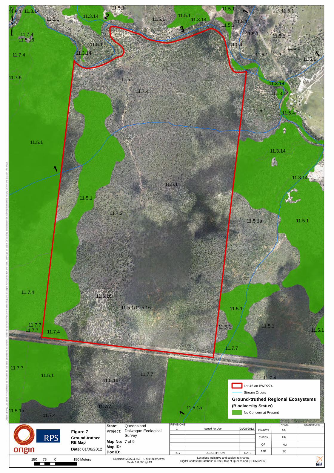
X-XXXX-XX-XX-XXXX
Dalwogan EcologicalSurvey
Queensland
Orig
in E
nerg
y Lt
d gi
ves
no w
arra
nty
in r
elat
ion
to th
e da
ta (
incl
udin
g ac
cura
cy, r
elia
bilit
y, c
ompl
eten
ess
or s
uita
bilit
y) a
nd a
ccep
ts n
o lia
bilit
y fo
r any
loss
, dam
age
or c
osts
(in
clud
ing
cons
eque
ntia
l dam
age)
rel
atin
g to
any
use
of t
he d
ata
in th
is m
ap.
State:
Map No:Map ID: Doc ID:
Project:REVISIONS
REV DESCRIPTION DATE
1 Issued for Use
7 of 9
NAME SIGNATURE
DRAWN
CHECK
QA
APP
Projection: MGA94 Z56 Units: Kilometres Scale 1:8,000 @ A3
Locations indicative and subject to changeDigital Cadastral Database © The State of Queensland (DERM) 2012.
11.5.1
11.5.1
11.5.1
11.5.16
11.5.1
11.5.1
11.7.7
11.5.1
11.7.4
11.7.7
11.7.7
11.5.1
11.5.1
11.5.16
11.5.1
11.5.1a
11.7.4
11.7.4
11.7.4
11.7.7
11.5.1
11.5.111.3.14
11.5.1
11.5.1a
11.5.1
11.7.4
11.7.7
11.5.1
11.5.1
11.7.4
11.3.1411.5.1
11.5.1
11.3.14
11.5.1
11.5.1/11.5.16
11.5.1
11.5.1a
11.3.14
11.5.1
11.7.2
11.5.1
11.3.14
11.7.5
11.5.1
11.5.1
11.5.1
11.5.4
11.7.7
11.3.1411.5.1
11.5.1
11.5.1
11.7.7
11.3.14
11.3.1411.5.1
11.5.1611.7.4
3
1
2
1
1
1
01/08/2012 CO
KM
HR
BD
150 0 15075 Meters
³
Lot 46 on BWR274
Stream Orders
Ground-truthed Regional Ecosystems(Biodiversity Status)
No Concern at Present
Figure 7
Date:
Ground-truthed RE Map
01/08/2012
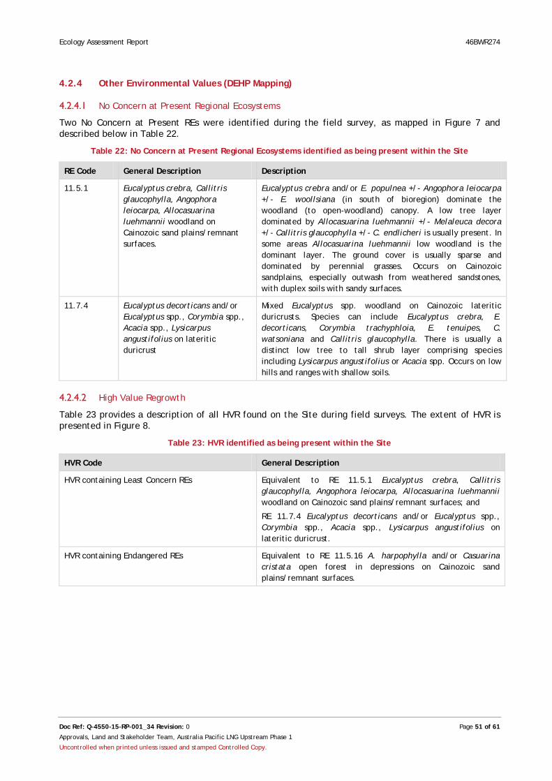
Ecology Assessment Report 46BWR274
Doc Ref: Q-4550-15-RP-001_34 Revision: 0 Page 51 of 61
Approvals, Land and Stakeholder Team, Australia Pacific LNG Upstream Phase 1
Uncontrolled when printed unless issued and stamped Controlled Copy.
4.2.4 Other Environmental Values (DEHP Mapping)
4.2.4.1 No Concern at Present Regional Ecosystems
Two No Concern at Present REs were identified during the field survey, as mapped in Figure 7 and described below in Table 22.
Table 22: No Concern at Present Regional Ecosystems identified as being present within the Site
RE Code General Description Description
11.5.1 Eucalyptus crebra, Callitris glaucophylla, Angophora leiocarpa, Allocasuarina luehmannii woodland on Cainozoic sand plains/remnant surfaces.
Eucalyptus crebra and/or E. populnea +/- Angophora leiocarpa +/- E. woollsiana (in south of bioregion) dominate the woodland (to open-woodland) canopy. A low tree layer dominated by Allocasuarina luehmannii +/- Melaleuca decora +/- Callitris glaucophylla +/- C. endlicheri is usually present. In some areas Allocasuarina luehmannii low woodland is the dominant layer. The ground cover is usually sparse and dominated by perennial grasses. Occurs on Cainozoic sandplains, especially outwash from weathered sandstones, with duplex soils with sandy surfaces.
11.7.4 Eucalyptus decorticans and/or Eucalyptus spp., Corymbia spp., Acacia spp., Lysicarpus angustifolius on lateritic duricrust
Mixed Eucalyptus spp. woodland on Cainozoic lateritic duricrusts. Species can include Eucalyptus crebra, E. decorticans, Corymbia trachyphloia, E. tenuipes, C. watsoniana and Callitris glaucophylla. There is usually a distinct low tree to tall shrub layer comprising species including Lysicarpus angustifolius or Acacia spp. Occurs on low hills and ranges with shallow soils.
4.2.4.2 High Value Regrowth
Table 23 provides a description of all HVR found on the Site during field surveys. The extent of HVR is presented in Figure 8.
Table 23: HVR identified as being present within the Site
HVR Code General Description
HVR containing Least Concern REs Equivalent to RE 11.5.1 Eucalyptus crebra, Callitris glaucophylla, Angophora leiocarpa, Allocasuarina luehmannii woodland on Cainozoic sand plains/remnant surfaces; and
RE 11.7.4 Eucalyptus decorticans and/or Eucalyptus spp., Corymbia spp., Acacia spp., Lysicarpus angustifolius on lateritic duricrust.
HVR containing Endangered REs Equivalent to RE 11.5.16 A. harpophylla and/or Casuarina cristata open forest in depressions on Cainozoic sand plains/remnant surfaces.

3
1
2
1
1
1
X-XXXX-XX-XX-XXXX
Dalwogan EcologicalSurvey
Queensland
Orig
in E
nerg
y Lt
d gi
ves
no w
arra
nty
in r
elat
ion
to th
e da
ta (
incl
udin
g ac
cura
cy, r
elia
bilit
y, c
ompl
eten
ess
or s
uita
bilit
y) a
nd a
ccep
ts n
o lia
bilit
y fo
r any
loss
, dam
age
or c
osts
(in
clud
ing
cons
eque
ntia
l dam
age)
rel
atin
g to
any
use
of t
he d
ata
in th
is m
ap.
State:
Map No:Map ID: Doc ID:
Project:REVISIONS
REV DESCRIPTION DATE
1 Issued for Use
8 of 9
NAME SIGNATURE
DRAWN
CHECK
QA
APP
Projection: MGA94 Z56 Units: Kilometres Scale 1:8,000 @ A3
Locations indicative and subject to changeDigital Cadastral Database © The State of Queensland (DERM) 2012.
01/08/2012 CO
KM
HR
BD
³
150 0 15075 Meters
Lot 46 on BWR274
Stream Orders
Ground-truthed High Value RegrowthLeast Concern
Figure 8
Date:
Ground-truthed HVR Map
01/08/2012

Ecology Assessment Report 46BWR274
Doc Ref: Q-4550-15-RP-001_34 Revision: 0 Page 53 of 61
Approvals, Land and Stakeholder Team, Australia Pacific LNG Upstream Phase 1
Uncontrolled when printed unless issued and stamped Controlled Copy.
4.2.5 Wetland Ecosystems Desktop and field investigations identified 49 ephemeral streams lines or drainage lines running through the greater Dalwogan area. All streams are headwater streams (first through third-order streams).
All creek lines and water bodies associated with the Site are presented in Figure 3.
4.2.6 Habitat Condition
Available habitat on the Site includes Eucalypt and Acacia woodland, a permanent and ephemeral waterway and associated riparian vegetation. Deep leaf litter, course woody debris and numerous fallen logs and termite mounds provided habitat for small mammals and reptiles, while a shrub-layer provided habitat for small birds.
The presence of endangered HVR 11.5.16 can present some habitat for threatened species such as the Yakka skink. The Site also contained some loose bark (<25%) and ground cover (<25%). The ecosystem is considered to be functioning moderately well with only one small vehicle track within the patch of HVR. The track is not considered large enough to fragment the TEC patch.
The presence of ephemeral watercourses and ponds, and remnant riparian vegetation also provided important habitat for fauna. Mature hollow bearing trees along the creek were likely to provide roost Sites for species such as the Little Pied Bat (Chalinolobus picatus) or Greater Long-eared Bat (Nyctophilus corbeni).
4.2.7 Disturbance
The majority of the Site was vegetated and in relatively good condition. However, little mature vegetation exists due to past clearing or logging activities. A small, cleared patch was located close to the northwest border and numerous internal vehicle tracks and fence lines were present across the Site. Disturbed areas recorded opportunistically across the Site are presented in Figure 9.
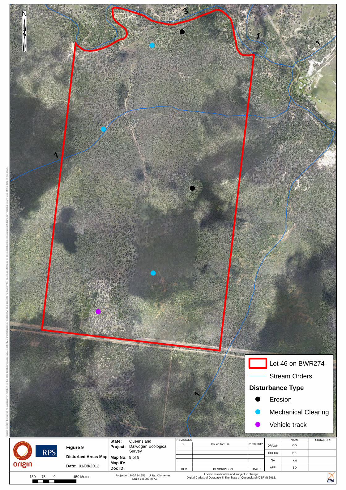
X-XXXX-XX-XX-XXXX
Dalwogan EcologicalSurvey
Queensland
Orig
in E
nerg
y Lt
d gi
ves
no w
arra
nty
in r
elat
ion
to th
e da
ta (
incl
udin
g ac
cura
cy, r
elia
bilit
y, c
ompl
eten
ess
or s
uita
bilit
y) a
nd a
ccep
ts n
o lia
bilit
y fo
r any
loss
, dam
age
or c
osts
(in
clud
ing
cons
eque
ntia
l dam
age)
rel
atin
g to
any
use
of t
he d
ata
in th
is m
ap.
State:
Map No:Map ID: Doc ID:
Project:REVISIONS
REV DESCRIPTION DATE
1 Issued for Use
9 of 9
NAME SIGNATURE
DRAWN
CHECK
QA
APP
Projection: MGA94 Z56 Units: Kilometres Scale 1:8,000 @ A3
Locations indicative and subject to changeDigital Cadastral Database © The State of Queensland (DERM) 2012.
!
!
!
!
!
!
1
3
11
1
01/08/2012 CO
KM
HR
BD
Lot 46 on BWR274
Stream Orders
Disturbance Type! Erosion
! Mechanical Clearing
! Vehicle track
³
150 0 15075 Meters
Figure 9
Date:Disturbed Areas Map
01/08/2012

Ecology Assessment Report 46BWR274
Doc Ref: Q-4550-15-RP-001_34 Revision: 0 Page 55 of 61
Approvals, Land and Stakeholder Team, Australia Pacific LNG Upstream Phase 1
Uncontrolled when printed unless issued and stamped Controlled Copy.
5.0 Conclusion This ecological assessment survey identified a number of ecological constraints at the Site, including the following:
• The presence of the Brigalow TEC (Figure 4)
• Threatened species habitat, described in Sections 6.2.1.3 and 6.2.2 and
• HVR containing Endangered REs (Figure 8).
Recommendations resulting from the ecological assessment survey include the following:
• Where possible, vegetation clearance should be limited to existing disturbed areas, especially cleared areas and any existing tracks
• Where possible, avoid clearing within the Brigalow TEC and Endangered HVR (Figure 4 and Figure 8)
• Avoid clearing of significant habitat features, such as hollow bearing trees which provide habitat for NC Reg threatened species such as the Little Pied Bat (Chalinolobus picatus).
One MNES was found on the Site, the Brigalow TEC. If works are to be undertaken within this area an EPBC Act referral is required.
It is recommended the findings in this report be considered during planning and operational phases to ensure that environmental impacts are avoided and mitigated at the Site (Lot 46 on BWR274). Wherever possible, identified constraints should be avoided during all seismic activities, or appropriate mitigation actions are to be put in place.
Compliance with Australia Pacific LNG management plans, guidelines, and permits (under both the State of Queensland and the Commonwealth of Australia) will ensure that impacts to ecological constraints identified within this report will be avoided and minimised where possible.

Ecology Assessment Report 46BWR274
Doc Ref: Q-4550-15-RP-001_34 Revision: 0 Page 56 of 61
Approvals, Land and Stakeholder Team, Australia Pacific LNG Upstream Phase 1
Uncontrolled when printed unless issued and stamped Controlled Copy.
6.0 Appendix A: Results of EPBC Act Protected Matters Search Tool

EPBC Act Protected Matters Report
This report provides general guidance on matters of national environmental significance and othermatters protected by the EPBC Act in the area you have selected.
Information on the coverage of this report and qualifications on data supporting this report arecontained in the caveat at the end of the report.
Information is available about Environment Assessments and the EPBC Act including significanceguidelines, forms and application process details.
Other Matters Protected by the EPBC Act
Acknowledgements
Buffer: 10.0Km
Matters of NES
Report created: 24/01/13 12:11:45
Coordinates
This map may contain data which are©Commonwealth of Australia(Geoscience Australia), ©PSMA 2010
CaveatExtra Information
DetailsSummary

Summary
This part of the report summarises the matters of national environmental significance that may occurin, or may relate to, the area you nominated. Further information is available in the detail part of thereport, which can be accessed by scrolling or following the links below. If you are proposing toundertake an activity that may have a significant impact on one or more matters of nationalenvironmental significance then you should consider the Administrative Guidelines on Significance.
Matters of National Environmental Significance
Listed Threatened Ecological Communities:
Listed Migratory Species:
4
Great Barrier Reef Marine Park:
Wetlands of International Importance:
Listed Threatened Species:
None
19
None
None
National Heritage Places:
Commonwealth Marine Areas:
World Heritage Properties:
1
None
12
This part of the report summarises other matters protected under the Act that may relate to the areayou nominated. Approval may be required for a proposed activity that significantly affects theenvironment on Commonwealth land, when the action is outside the Commonwealth land, or theenvironment anywhere when the action is taken on Commonwealth land. Approval may also berequired for the Commonwealth or Commonwealth agencies proposing to take an action that is likelyto have a significant impact on the environment anywhere.
The EPBC Act protects the environment on Commonwealth land, the environment from the actionstaken on Commonwealth land, and the environment from actions taken by Commonwealth agencies.As heritage values of a place are part of the 'environment', these aspects of the EPBC Act protect theCommonwealth Heritage values of a Commonwealth Heritage place and the heritage values of aplace on the Register of the National Estate.
This part of the report summarises other matters protected under the Act that may relate to the areayou nominated. Approval may be required for a proposed activity that significantly affects theenvironment on Commonwealth land, when the action is outside the Commonwealth land, or theenvironment anywhere when the action is taken on Commonwealth land. Approval may also berequired for the Commonwealth or Commonwealth agencies proposing to take an action that is likelyto have a significant impact on the environment anywhere.
A permit may be required for activities in or on a Commonwealth area that may affect a member of alisted threatened species or ecological community, a member of a listed migratory species, whalesand other cetaceans, or a member of a listed marine species.
Other Matters Protected by the EPBC Act
None
None
None
Listed Marine Species:
Whales and Other Cetaceans:
12
Commonwealth Heritage Places:
None
None
Critical Habitats:
Commonwealth Land:
Commonwealth Reserves:
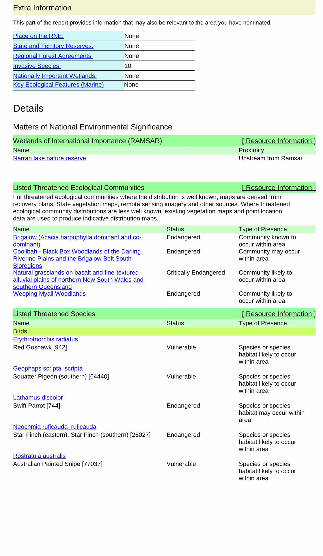
This part of the report provides information that may also be relevant to the area you have nominated.
Extra Information
Regional Forest Agreements:
10
Place on the RNE:
None
None
Invasive Species:
None
Nationally Important Wetlands:
State and Territory Reserves:
None
Key Ecological Features (Marine) None
Details
Wetlands of International Importance (RAMSAR) [ Resource Information ]Name ProximityNarran lake nature reserve Upstream from Ramsar
Listed Threatened Species [ Resource Information ]Name Status Type of PresenceBirds
Red Goshawk [942] Vulnerable Species or specieshabitat likely to occurwithin area
Erythrotriorchis radiatus
Squatter Pigeon (southern) [64440] Vulnerable Species or specieshabitat likely to occurwithin area
Geophaps scripta scripta
Swift Parrot [744] Endangered Species or specieshabitat may occur withinarea
Lathamus discolor
Star Finch (eastern), Star Finch (southern) [26027] Endangered Species or specieshabitat likely to occurwithin area
Neochmia ruficauda ruficauda
Australian Painted Snipe [77037] Vulnerable Species or specieshabitat likely to occurwithin area
Rostratula australis
For threatened ecological communities where the distribution is well known, maps are derived fromrecovery plans, State vegetation maps, remote sensing imagery and other sources. Where threatenedecological community distributions are less well known, existing vegetation maps and point locationdata are used to produce indicative distribution maps.
Listed Threatened Ecological Communities [ Resource Information ]
Name Status Type of PresenceBrigalow (Acacia harpophylla dominant and co-dominant)
Endangered Community known tooccur within area
Coolibah - Black Box Woodlands of the DarlingRiverine Plains and the Brigalow Belt SouthBioregions
Endangered Community may occurwithin area
Natural grasslands on basalt and fine-texturedalluvial plains of northern New South Wales andsouthern Queensland
Critically Endangered Community likely tooccur within area
Weeping Myall Woodlands Endangered Community likely tooccur within area
Matters of National Environmental Significance
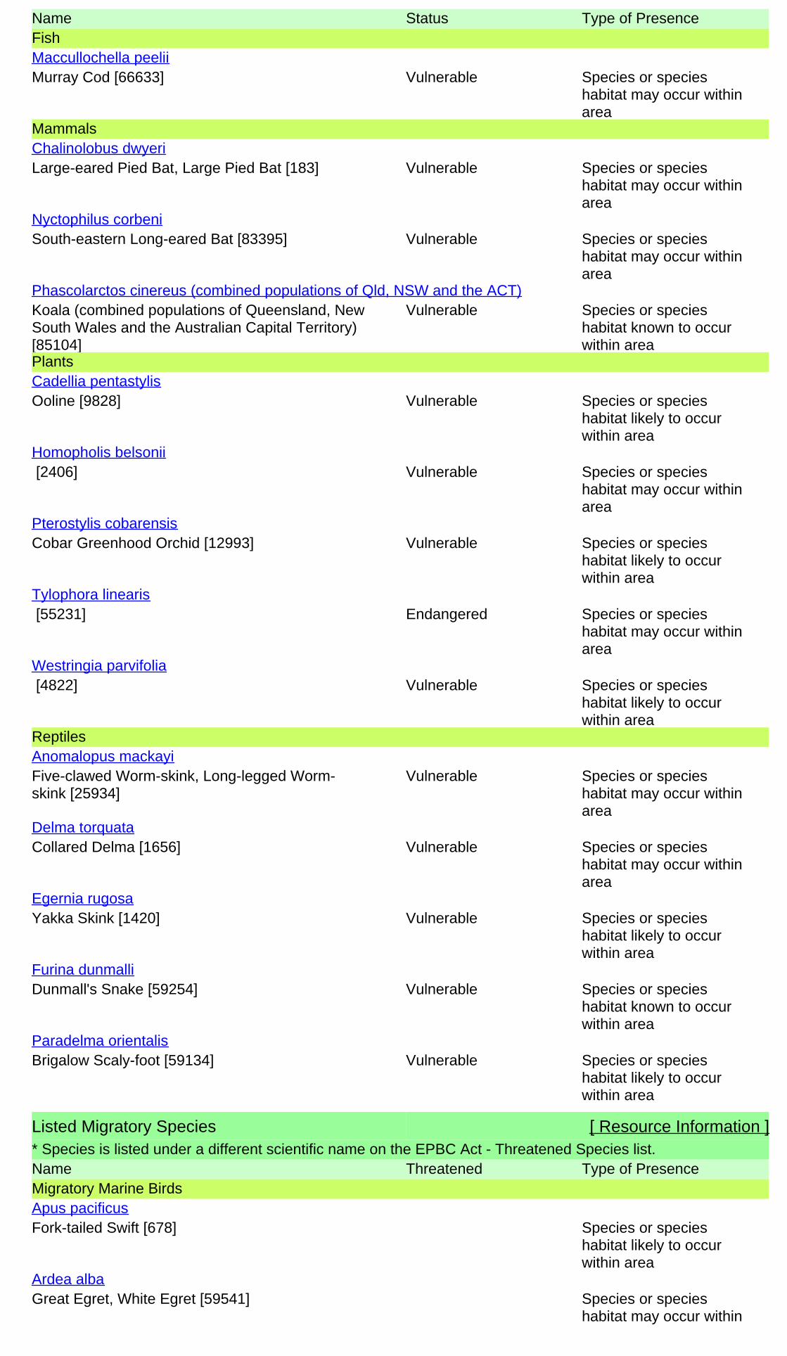
Name Status Type of PresenceFish
Murray Cod [66633] Vulnerable Species or specieshabitat may occur withinarea
Maccullochella peelii
Mammals
Large-eared Pied Bat, Large Pied Bat [183] Vulnerable Species or specieshabitat may occur withinarea
Chalinolobus dwyeri
South-eastern Long-eared Bat [83395] Vulnerable Species or specieshabitat may occur withinarea
Nyctophilus corbeni
Koala (combined populations of Queensland, NewSouth Wales and the Australian Capital Territory)[85104]
Vulnerable Species or specieshabitat known to occurwithin area
Phascolarctos cinereus (combined populations of Qld, NSW and the ACT)
Plants
Ooline [9828] Vulnerable Species or specieshabitat likely to occurwithin area
Cadellia pentastylis
[2406] Vulnerable Species or specieshabitat may occur withinarea
Homopholis belsonii
Cobar Greenhood Orchid [12993] Vulnerable Species or specieshabitat likely to occurwithin area
Pterostylis cobarensis
[55231] Endangered Species or specieshabitat may occur withinarea
Tylophora linearis
[4822] Vulnerable Species or specieshabitat likely to occurwithin area
Westringia parvifolia
Reptiles
Five-clawed Worm-skink, Long-legged Worm-skink [25934]
Vulnerable Species or specieshabitat may occur withinarea
Anomalopus mackayi
Collared Delma [1656] Vulnerable Species or specieshabitat may occur withinarea
Delma torquata
Yakka Skink [1420] Vulnerable Species or specieshabitat likely to occurwithin area
Egernia rugosa
Dunmall's Snake [59254] Vulnerable Species or specieshabitat known to occurwithin area
Furina dunmalli
Brigalow Scaly-foot [59134] Vulnerable Species or specieshabitat likely to occurwithin area
Paradelma orientalis
Listed Migratory Species [ Resource Information ]* Species is listed under a different scientific name on the EPBC Act - Threatened Species list.Name Threatened Type of PresenceMigratory Marine Birds
Fork-tailed Swift [678] Species or specieshabitat likely to occurwithin area
Apus pacificus
Great Egret, White Egret [59541] Species or specieshabitat may occur within
Ardea alba
Name Threatened Type of Presencearea
Cattle Egret [59542] Species or specieshabitat may occur withinarea
Ardea ibis
Migratory Terrestrial Species
White-bellied Sea-Eagle [943] Species or specieshabitat likely to occurwithin area
Haliaeetus leucogaster
White-throated Needletail [682] Species or specieshabitat may occur withinarea
Hirundapus caudacutus
Rainbow Bee-eater [670] Species or specieshabitat may occur withinarea
Merops ornatus
Satin Flycatcher [612] Species or specieshabitat may occur withinarea
Myiagra cyanoleuca
Rufous Fantail [592] Species or specieshabitat may occur withinarea
Rhipidura rufifrons
Migratory Wetlands Species
Great Egret, White Egret [59541] Species or specieshabitat may occur withinarea
Ardea alba
Cattle Egret [59542] Species or specieshabitat may occur withinarea
Ardea ibis
Latham's Snipe, Japanese Snipe [863] Species or specieshabitat may occur withinarea
Gallinago hardwickii
Painted Snipe [889] Vulnerable* Species or specieshabitat likely to occurwithin area
Rostratula benghalensis (sensu lato)
Listed Marine Species [ Resource Information ]* Species is listed under a different scientific name on the EPBC Act - Threatened Species list.Name Threatened Type of PresenceBirds
Magpie Goose [978] Species or specieshabitat may occur withinarea
Anseranas semipalmata
Fork-tailed Swift [678] Species or specieshabitat likely to occurwithin area
Apus pacificus
Great Egret, White Egret [59541] Species or specieshabitat may occur withinarea
Ardea alba
Cattle Egret [59542] Species or specieshabitat may occur withinarea
Ardea ibis
Latham's Snipe, Japanese Snipe [863] Species or speciesGallinago hardwickii
Other Matters Protected by the EPBC Act
Name Threatened Type of Presencehabitat may occur withinarea
White-bellied Sea-Eagle [943] Species or specieshabitat likely to occurwithin area
Haliaeetus leucogaster
White-throated Needletail [682] Species or specieshabitat may occur withinarea
Hirundapus caudacutus
Swift Parrot [744] Endangered Species or specieshabitat may occur withinarea
Lathamus discolor
Rainbow Bee-eater [670] Species or specieshabitat may occur withinarea
Merops ornatus
Satin Flycatcher [612] Species or specieshabitat may occur withinarea
Myiagra cyanoleuca
Rufous Fantail [592] Species or specieshabitat may occur withinarea
Rhipidura rufifrons
Painted Snipe [889] Vulnerable* Species or specieshabitat likely to occurwithin area
Rostratula benghalensis (sensu lato)
Extra Information
Invasive Species [ Resource Information ]Weeds reported here are the 20 species of national significance (WoNS), along with other introducedplants that are considered by the States and Territories to pose a particularly significant threat tobiodiversity. The following feral animals are reported: Goat, Red Fox, Cat, Rabbit, Pig, Water Buffaloand Cane Toad. Maps from Landscape Health Project, National Land and Water Resouces Audit,2001.
Name Status Type of PresenceFrogs
Cane Toad [1772] Species or specieshabitat likely to occurwithin area
Bufo marinus
Mammals
Cat, House Cat, Domestic Cat [19] Species or specieshabitat likely to occurwithin area
Felis catus
Rabbit, European Rabbit [128] Species or specieshabitat likely to occurwithin area
Oryctolagus cuniculus
Pig [6] Species or specieshabitat likely to occurwithin area
Sus scrofa

Name Status Type of Presence
Red Fox, Fox [18] Species or specieshabitat likely to occurwithin area
Vulpes vulpes
Plants
Prickly Acacia [6196] Species or specieshabitat may occur withinarea
Acacia nilotica subsp. indica
Hymenachne, Olive Hymenachne, Water Stargrass,West Indian Grass, West Indian Marsh Grass[31754]
Species or specieshabitat likely to occurwithin area
Hymenachne amplexicaulis
Parkinsonia, Jerusalem Thorn, Jelly Bean Tree,Horse Bean [12301]
Species or specieshabitat likely to occurwithin area
Parkinsonia aculeata
Parthenium Weed, Bitter Weed, Carrot Grass, FalseRagweed [19566]
Species or specieshabitat likely to occurwithin area
Parthenium hysterophorus
Salvinia, Giant Salvinia, Aquarium Watermoss,Kariba Weed [13665]
Species or specieshabitat likely to occurwithin area
Salvinia molesta
-26.67993 150.13438
Coordinates
- non-threatened seabirds which have only been mapped for recorded breeding sites
- migratory species that are very widespread, vagrant, or only occur in small numbers
- some species and ecological communities that have only recently been listed
Not all species listed under the EPBC Act have been mapped (see below) and therefore a report is a generalguide only. Where available data supports mapping, the type of presence that can be determined from thedata is indicated in general terms. People using this information in making a referral may need to considerthe qualifications below and may need to seek and consider other information sources.
For threatened ecological communities where the distribution is well known, maps are derived fromrecovery plans, State vegetation maps, remote sensing imagery and other sources. Where threatenedecological community distributions are less well known, existing vegetation maps and point location dataare used to produce indicative distribution maps.
- seals which have only been mapped for breeding sites near the Australian continentSuch breeding sites may be important for the protection of the Commonwealth Marine environment.
For species where the distributions are well known, maps are digitised from sources such as recovery plansand detailed habitat studies. Where appropriate, core breeding, foraging and roosting areas are indicatedunder 'type of presence'. For species whose distributions are less well known, point locations are collatedfrom government wildlife authorities, museums, and non-government organisations; bioclimaticdistribution models are generated and these validated by experts. In some cases, the distribution maps arebased solely on expert knowledge.
The information presented in this report has been provided by a range of data sources as acknowledged atthe end of the report.
Caveat
- migratory and
The following species and ecological communities have not been mapped and do not appear in reportsproduced from this database:
- marine
This report is designed to assist in identifying the locations of places which may be relevant in determiningobligations under the Environment Protection and Biodiversity Conservation Act 1999. It holds mappedlocations of World Heritage and Register of National Estate properties, Wetlands of InternationalImportance, Commonwealth and State/Territory reserves, listed threatened, migratory and marine speciesand listed threatened ecological communities. Mapping of Commonwealth land is not complete at thisstage. Maps have been collated from a range of sources at various resolutions.
- threatened species listed as extinct or considered as vagrants
- some terrestrial species that overfly the Commonwealth marine area
The following groups have been mapped, but may not cover the complete distribution of the species:
Only selected species covered by the following provisions of the EPBC Act have been mapped:
-Department of the Environment, Climate Change, Energy and Water-Birds Australia-Australian Bird and Bat Banding Scheme
-Department of Environment and Conservation, Western Australia
Acknowledgements
-Department of Environment, Climate Change and Water, New South Wales
-Department of Primary Industries, Parks, Water and Environment, Tasmania
-Parks and Wildlife Service NT, NT Dept of Natural Resources, Environment and the Arts-Environmental and Resource Management, Queensland
-Department of Sustainability and Environment, Victoria
-Australian National Wildlife Collection
-Department of Environment and Natural Resources, South Australia
This database has been compiled from a range of data sources. The department acknowledges thefollowing custodians who have contributed valuable data and advice:
-Australian Museum
-National Herbarium of NSW
-State Forests of NSW-Australian Government, Department of Defence
-State Herbarium of South Australia
The Department is extremely grateful to the many organisations and individuals who providedexpert advice and information on numerous draft distributions.
-Natural history museums of Australia
-Queensland Museum
-Australian National Herbarium, Atherton and Canberra
-Royal Botanic Gardens and National Herbarium of Victoria
-Geoscience Australia
-Ocean Biogeographic Information System
-Online Zoological Collections of Australian Museums-Queensland Herbarium
-Western Australian Herbarium
-Tasmanian Herbarium
-Northern Territory Herbarium
-SA Museum
-Museum Victoria
-University of New England
-CSIRO-Other groups and individuals
© Commonwealth of Australia
+61 2 6274 1111
Canberra ACT 2601 Australia
GPO Box 787
Department of Sustainability, Environment, Water, Population and Communities
Please feel free to provide feedback via the Contact Us page.

Ecology Assessment Report 46BWR274
Doc Ref: Q-4550-15-RP-001_34 Revision: 0 Page 57 of 61
Approvals, Land and Stakeholder Team, Australia Pacific LNG Upstream Phase 1
Uncontrolled when printed unless issued and stamped Controlled Copy.
7.0 Appendix B: Results of Wildlife Online database search
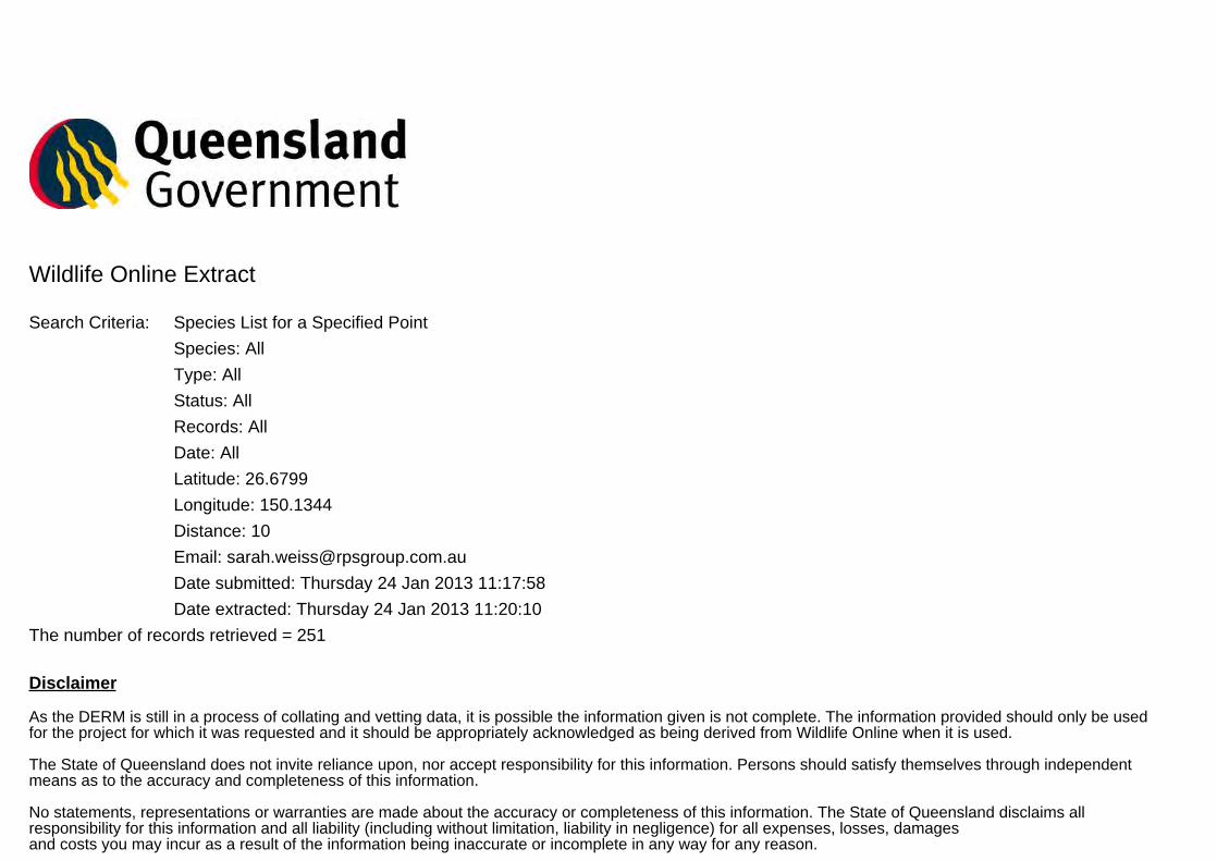
Wildlife Online Extract
Search Criteria: Species List for a Specified Point
Species: All
Type: All
Status: All
Records: All
Date: All
Latitude: 26.6799
Longitude: 150.1344
Distance: 10
Email: [email protected]
Date submitted: Thursday 24 Jan 2013 11:17:58
Date extracted: Thursday 24 Jan 2013 11:20:10
The number of records retrieved = 251
Disclaimer
As the DERM is still in a process of collating and vetting data, it is possible the information given is not complete. The information provided should only be usedfor the project for which it was requested and it should be appropriately acknowledged as being derived from Wildlife Online when it is used.
The State of Queensland does not invite reliance upon, nor accept responsibility for this information. Persons should satisfy themselves through independentmeans as to the accuracy and completeness of this information.
No statements, representations or warranties are made about the accuracy or completeness of this information. The State of Queensland disclaims allresponsibility for this information and all liability (including without limitation, liability in negligence) for all expenses, losses, damagesand costs you may incur as a result of the information being inaccurate or incomplete in any way for any reason.
Feedback about Wildlife Online should be emailed to [email protected]
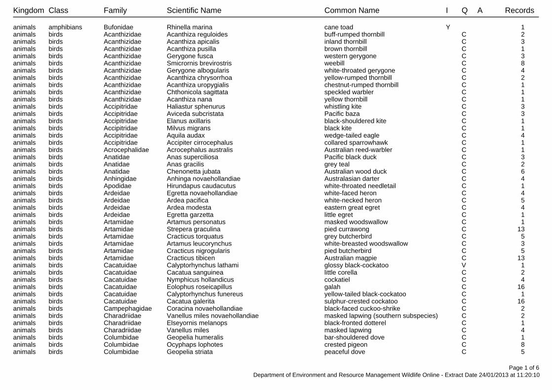
Kingdom Class Family Scientific Name Common Name I Q A Records
animals amphibians Bufonidae Rhinella marina cane toad Y 1 animals birds Acanthizidae Acanthiza reguloides buff-rumped thornbill C 2 animals birds Acanthizidae Acanthiza apicalis inland thornbill C 3 animals birds Acanthizidae Acanthiza pusilla brown thornbill C 1 animals birds Acanthizidae Gerygone fusca western gerygone C 3 animals birds Acanthizidae Smicrornis brevirostris weebill C 8 animals birds Acanthizidae Gerygone albogularis white-throated gerygone C 4 animals birds Acanthizidae Acanthiza chrysorrhoa yellow-rumped thornbill C 2 animals birds Acanthizidae Acanthiza uropygialis chestnut-rumped thornbill C 1 animals birds Acanthizidae Chthonicola sagittata speckled warbler C 1 animals birds Acanthizidae Acanthiza nana yellow thornbill C 1 animals birds Accipitridae Haliastur sphenurus whistling kite C 3 animals birds Accipitridae Aviceda subcristata Pacific baza C 3 animals birds Accipitridae Elanus axillaris black-shouldered kite C 1 animals birds Accipitridae Milvus migrans black kite C 1 animals birds Accipitridae Aquila audax wedge-tailed eagle C 4 animals birds Accipitridae Accipiter cirrocephalus collared sparrowhawk C 1 animals birds Acrocephalidae Acrocephalus australis Australian reed-warbler C 1 animals birds Anatidae Anas superciliosa Pacific black duck C 3 animals birds Anatidae Anas gracilis grey teal C 2 animals birds Anatidae Chenonetta jubata Australian wood duck C 6 animals birds Anhingidae Anhinga novaehollandiae Australasian darter C 4 animals birds Apodidae Hirundapus caudacutus white-throated needletail C 1 animals birds Ardeidae Egretta novaehollandiae white-faced heron C 4 animals birds Ardeidae Ardea pacifica white-necked heron C 5 animals birds Ardeidae Ardea modesta eastern great egret C 4 animals birds Ardeidae Egretta garzetta little egret C 1 animals birds Artamidae Artamus personatus masked woodswallow C 1 animals birds Artamidae Strepera graculina pied currawong C 13 animals birds Artamidae Cracticus torquatus grey butcherbird C 5 animals birds Artamidae Artamus leucorynchus white-breasted woodswallow C 3 animals birds Artamidae Cracticus nigrogularis pied butcherbird C 5 animals birds Artamidae Cracticus tibicen Australian magpie C 13 animals birds Cacatuidae Calyptorhynchus lathami glossy black-cockatoo V 1 animals birds Cacatuidae Cacatua sanguinea little corella C 2 animals birds Cacatuidae Nymphicus hollandicus cockatiel C 4 animals birds Cacatuidae Eolophus roseicapillus galah C 16 animals birds Cacatuidae Calyptorhynchus funereus yellow-tailed black-cockatoo C 1 animals birds Cacatuidae Cacatua galerita sulphur-crested cockatoo C 16 animals birds Campephagidae Coracina novaehollandiae black-faced cuckoo-shrike C 2 animals birds Charadriidae Vanellus miles novaehollandiae masked lapwing (southern subspecies) C 2 animals birds Charadriidae Elseyornis melanops black-fronted dotterel C 1 animals birds Charadriidae Vanellus miles masked lapwing C 4 animals birds Columbidae Geopelia humeralis bar-shouldered dove C 1 animals birds Columbidae Ocyphaps lophotes crested pigeon C 8 animals birds Columbidae Geopelia striata peaceful dove C 5
Page 1 of 6Department of Environment and Resource Management Wildlife Online - Extract Date 24/01/2013 at 11:20:10

Kingdom Class Family Scientific Name Common Name I Q A Records
animals birds Columbidae Geopelia cuneata diamond dove C 1 animals birds Columbidae Columba livia rock dove Y 5 animals birds Coraciidae Eurystomus orientalis dollarbird C 1 animals birds Corcoracidae Struthidea cinerea apostlebird C 10 animals birds Corcoracidae Corcorax melanorhamphos white-winged chough C 5 animals birds Corvidae Corvus sp. 1 animals birds Corvidae Corvus bennetti little crow C 2 animals birds Corvidae Corvus coronoides Australian raven C 2 animals birds Corvidae Corvus orru Torresian crow C 19 animals birds Cuculidae Eudynamys orientalis eastern koel C 2 animals birds Cuculidae Centropus phasianinus pheasant coucal C 1 animals birds Cuculidae Chalcites lucidus shining bronze-cuckoo C 1 animals birds Estrildidae Neochmia modesta plum-headed finch C 1 animals birds Estrildidae Taeniopygia bichenovii double-barred finch C 2 animals birds Estrildidae Lonchura punctulata nutmeg mannikin Y 1 animals birds Falconidae Falco cenchroides nankeen kestrel C 3 animals birds Falconidae Falco berigora brown falcon C 1 animals birds Halcyonidae Dacelo novaeguineae laughing kookaburra C 6 animals birds Halcyonidae Todiramphus sanctus sacred kingfisher C 4 animals birds Hirundinidae Petrochelidon ariel fairy martin C 3 animals birds Hirundinidae Hirundo neoxena welcome swallow C 9 animals birds Hirundinidae Petrochelidon nigricans tree martin C 3 animals birds Maluridae Malurus cyaneus superb fairy-wren C 8 animals birds Maluridae Malurus lamberti variegated fairy-wren C 3 animals birds Meliphagidae Manorina flavigula yellow-throated miner C 3 animals birds Meliphagidae Gavicalis virescens singing honeyeater C 1 animals birds Meliphagidae Lichmera indistincta brown honeyeater C 8 animals birds Meliphagidae Melithreptus gularis black-chinned honeyeater NT 1 animals birds Meliphagidae Nesoptilotis leucotis white-eared honeyeater C 5/1animals birds Meliphagidae Philemon corniculatus noisy friarbird C 7 animals birds Meliphagidae Manorina melanocephala noisy miner C 15 animals birds Meliphagidae Myzomela sanguinolenta scarlet honeyeater C 2 animals birds Meliphagidae Philemon citreogularis little friarbird C 9 animals birds Meliphagidae Ptilotula penicillatus white-plumed honeyeater C 4 animals birds Meliphagidae Acanthagenys rufogularis spiny-cheeked honeyeater C 1 animals birds Meliphagidae Plectorhyncha lanceolata striped honeyeater C 6 animals birds Meliphagidae Melithreptus brevirostris brown-headed honeyeater C 2/1animals birds Meliphagidae Entomyzon cyanotis blue-faced honeyeater C 10 animals birds Meliphagidae Sugomel niger black honeyeater C 1 animals birds Meliphagidae Caligavis chrysops yellow-faced honeyeater C 1 animals birds Meropidae Merops ornatus rainbow bee-eater C 4 animals birds Monarchidae Grallina cyanoleuca magpie-lark C 18 animals birds Monarchidae Myiagra rubecula leaden flycatcher C 1 animals birds Motacillidae Anthus novaeseelandiae Australasian pipit C 1 animals birds Nectariniidae Dicaeum hirundinaceum mistletoebird C 3 animals birds Neosittidae Daphoenositta chrysoptera varied sittella C 1
Page 2 of 6Department of Environment and Resource Management Wildlife Online - Extract Date 24/01/2013 at 11:20:10

Kingdom Class Family Scientific Name Common Name I Q A Records
animals birds Oriolidae Oriolus sagittatus olive-backed oriole C 1 animals birds Otididae Ardeotis australis Australian bustard C 2 animals birds Pachycephalidae Colluricincla harmonica grey shrike-thrush C 4 animals birds Pachycephalidae Pachycephala pectoralis golden whistler C 2 animals birds Pachycephalidae Pachycephala rufiventris rufous whistler C 4 animals birds Pardalotidae Pardalotus striatus striated pardalote C 17 animals birds Pardalotidae Pardalotus punctatus spotted pardalote C 2 animals birds Passeridae Passer domesticus house sparrow Y 3 animals birds Pelecanidae Pelecanus conspicillatus Australian pelican C 1 animals birds Petroicidae Eopsaltria australis eastern yellow robin C 1 animals birds Petroicidae Petroica goodenovii red-capped robin C 2 animals birds Petroicidae Microeca fascinans jacky winter C 1 animals birds Phalacrocoracidae Phalacrocorax carbo great cormorant C 2 animals birds Phalacrocoracidae Phalacrocorax sulcirostris little black cormorant C 2 animals birds Phasianidae Coturnix pectoralis stubble quail C 1 animals birds Podargidae Podargus strigoides tawny frogmouth C 1 animals birds Pomatostomidae Pomatostomus temporalis grey-crowned babbler C 5 animals birds Psittacidae Trichoglossus haematodus moluccanus rainbow lorikeet C 5 animals birds Psittacidae Psephotus varius mulga parrot C 2 animals birds Psittacidae Alisterus scapularis Australian king-parrot C 1 animals birds Psittacidae Platycercus adscitus pale-headed rosella C 6 animals birds Psittacidae Melopsittacus undulatus budgerigar C 1 animals birds Psittacidae Aprosmictus erythropterus red-winged parrot C 7 animals birds Psittacidae Trichoglossus chlorolepidotus scaly-breasted lorikeet C 8 animals birds Rallidae Gallinula tenebrosa dusky moorhen C 2 animals birds Rhipiduridae Rhipidura leucophrys willie wagtail C 16 animals birds Rhipiduridae Rhipidura albiscapa grey fantail C 4 animals birds Threskiornithidae Threskiornis molucca Australian white ibis C 3 animals birds Threskiornithidae Platalea regia royal spoonbill C 3 animals birds Threskiornithidae Platalea flavipes yellow-billed spoonbill C 1 animals birds Turnicidae Turnix velox little button-quail C 2 animals bony fish Percichthyidae Macquaria ambigua golden perch 2 animals mammals Macropodidae Macropus giganteus eastern grey kangaroo C 1 animals mammals Macropodidae Macropus rufogriseus red-necked wallaby C 2 animals mammals Macropodidae Wallabia bicolor swamp wallaby C 1 animals mammals Phalangeridae Trichosurus vulpecula common brushtail possum C 1 animals mammals Potoroidae Aepyprymnus rufescens rufous bettong C 2/1animals mammals Tachyglossidae Tachyglossus aculeatus short-beaked echidna C 1 animals reptiles Agamidae Pogona barbata bearded dragon C 1 animals reptiles Diplodactylidae Lucasium steindachneri Steindachner's gecko C 1 animals reptiles Gekkonidae Heteronotia binoei Bynoe's gecko C 2 animals reptiles Gekkonidae Gehyra dubia C 1 animals reptiles Scincidae Morethia sp. 1 animals reptiles Scincidae Ctenotus robustus C 1 animals reptiles Scincidae Cryptoblepharus pulcher pulcher elegant snake-eyed skink C 1 animals reptiles Scincidae Carlia pectoralis sensu lato C 1
Page 3 of 6Department of Environment and Resource Management Wildlife Online - Extract Date 24/01/2013 at 11:20:10
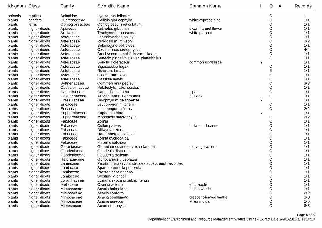
Kingdom Class Family Scientific Name Common Name I Q A Records
animals reptiles Scincidae Lygisaurus foliorum C 1 plants conifers Cupressaceae Callitris glaucophylla white cypress pine C 1/1plants ferns Ophioglossaceae Ophioglossum reticulatum C 1/1plants higher dicots Apiaceae Actinotus gibbonsii dwarf flannel flower C 1/1plants higher dicots Araliaceae Trachymene ochracea white parsnip C 1/1plants higher dicots Asteraceae Leptorhynchos baileyi C 1/1plants higher dicots Asteraceae Rutidosis murchisonii C 2/2plants higher dicots Asteraceae Solenogyne bellioides C 1/1plants higher dicots Asteraceae Ozothamnus diotophyllus C 4/4plants higher dicots Asteraceae Brachyscome multifida var. dilatata C 1/1plants higher dicots Asteraceae Senecio pinnatifolius var. pinnatifolius C 1/1plants higher dicots Asteraceae Sonchus oleraceus common sowthistle Y 1/1plants higher dicots Asteraceae Sigesbeckia fugax C 1/1plants higher dicots Asteraceae Rutidosis lanata E 1/1plants higher dicots Asteraceae Olearia ramulosa C 1/1plants higher dicots Asteraceae Cassinia laevis C 1/1plants higher dicots Byttneriaceae Commersonia pedleyi C 3/3plants higher dicots Caesalpiniaceae Petalostylis labicheoides C 1/1plants higher dicots Capparaceae Capparis lasiantha nipan C 1/1plants higher dicots Casuarinaceae Allocasuarina luehmannii bull oak C 1/1plants higher dicots Crassulaceae Bryophyllum delagoense Y 1/1plants higher dicots Ericaceae Leucopogon mitchellii C 1/1plants higher dicots Ericaceae Leucopogon biflorus C 2/2plants higher dicots Euphorbiaceae Euphorbia hirta Y 1/1plants higher dicots Euphorbiaceae Monotaxis macrophylla C 2/2plants higher dicots Fabaceae Zornia C 1/1plants higher dicots Fabaceae Cullen patens bullamon lucerne C 1/1plants higher dicots Fabaceae Dillwynia retorta C 1/1plants higher dicots Fabaceae Hardenbergia violacea C 1/1plants higher dicots Fabaceae Zornia dyctiocarpa C 1/1plants higher dicots Fabaceae Mirbelia aotoides C 1/1plants higher dicots Geraniaceae Geranium solanderi var. solanderi native geranium C 1/1plants higher dicots Goodeniaceae Goodenia disperma C 1/1plants higher dicots Goodeniaceae Goodenia delicata C 1/1plants higher dicots Haloragaceae Gonocarpus urceolatus C 1/1plants higher dicots Lamiaceae Prostanthera cryptandroides subsp. euphrasioides C 1/1plants higher dicots Lamiaceae Spartothamnella puberula C 1/1plants higher dicots Lamiaceae Prostanthera ringens C 1/1plants higher dicots Lamiaceae Westringia cheelii C 1/1plants higher dicots Loranthaceae Lysiana exocarpi subsp. tenuis C 1/1plants higher dicots Meliaceae Owenia acidula emu apple C 1/1plants higher dicots Mimosaceae Acacia hakeoides hakea wattle C 1/1plants higher dicots Mimosaceae Acacia conferta C 2/2plants higher dicots Mimosaceae Acacia semilunata crescent-leaved wattle C 3/3plants higher dicots Mimosaceae Acacia aprepta Miles mulga C 5/5plants higher dicots Mimosaceae Acacia ixiophylla C 6/6
Page 4 of 6Department of Environment and Resource Management Wildlife Online - Extract Date 24/01/2013 at 11:20:10

Kingdom Class Family Scientific Name Common Name I Q A Records
plants higher dicots Mimosaceae Acacia macradenia zig-zag wattle C 1/1plants higher dicots Mimosaceae Acacia burrowii C 1/1plants higher dicots Mimosaceae Acacia spectabilis pilliga wattle C 1/1plants higher dicots Mimosaceae Acacia leiocalyx subsp. leiocalyx C 2/2plants higher dicots Molluginaceae Glinus oppositifolius C 1/1plants higher dicots Myrsinaceae Lysimachia arvensis Y 1/1plants higher dicots Myrtaceae Eucalyptus tereticornis subsp. tereticornis C 1/1plants higher dicots Myrtaceae Eucalyptus panda C 2/2plants higher dicots Myrtaceae Kardomia jucunda C 2/2plants higher dicots Myrtaceae Melaleuca nodosa C 1/1plants higher dicots Myrtaceae Eucalyptus crebra narrow-leaved red ironbark C 1/1plants higher dicots Myrtaceae Eucalyptus elegans C 3/3plants higher dicots Myrtaceae Eucalyptus exserta Queensland peppermint C 2/2plants higher dicots Myrtaceae Eucalyptus tenuipes narrow-leaved white mahogany C 1/1plants higher dicots Myrtaceae Angophora floribunda rough-barked apple C 1/1plants higher dicots Myrtaceae Melaleuca pallescens C 3/3plants higher dicots Myrtaceae Micromyrtus sessilis C 2/2plants higher dicots Myrtaceae Eucalyptus chloroclada Baradine red gum C 3/3plants higher dicots Myrtaceae Melaleuca densispicata C 1/1plants higher dicots Myrtaceae Eucalyptus fibrosa subsp. nubila C 1/1plants higher dicots Myrtaceae Eucalyptus fibrosa subsp. fibrosa C 1/1plants higher dicots Myrtaceae Corymbia citriodora subsp. variegata C 1/1plants higher dicots Oleaceae Jasminum didymum subsp. racemosum C 1/1plants higher dicots Onagraceae Oenothera lindheimeri Y 1/1plants higher dicots Oxalidaceae Oxalis radicosa C 1/1plants higher dicots Portulacaceae Grahamia australiana C 1/1plants higher dicots Portulacaceae Portulaca C 1/1plants higher dicots Portulacaceae Calandrinia C 1/1plants higher dicots Portulacaceae Portulaca bicolor C 1/1plants higher dicots Proteaceae Hakea purpurea C 1/1plants higher dicots Rhamnaceae Cryptandra armata C 2/2plants higher dicots Rutaceae Philotheca difformis subsp. difformis C 2/2plants higher dicots Rutaceae Boronia occidentalis C 2/2plants higher dicots Rutaceae Boronia bipinnata rock boronia C 1/1plants higher dicots Rutaceae Phebalium nottii pink phebalium C 2/2plants higher dicots Rutaceae Zieria aspalathoides subsp. aspalathoides C 1/1plants higher dicots Sapindaceae Dodonaea vestita C 1/1plants higher dicots Sapindaceae Dodonaea biloba C 8/8plants higher dicots Sapindaceae Dodonaea macrossanii C 3/3plants higher dicots Scrophulariaceae Glossostigma diandrum C 1/1plants higher dicots Scrophulariaceae Linaria maroccana Y 1/1plants higher dicots Scrophulariaceae Misopates orontium lesser snapdragon Y 1/1plants higher dicots Scrophulariaceae Lindernia sp. (Bribie Island S.T.Blake 7089) C 1/1plants higher dicots Solanaceae Solanum nemophilum C 1/1plants higher dicots Sterculiaceae Brachychiton populneus subsp. trilobus C 2/2plants higher dicots Verbenaceae Glandularia aristigera Y 1/1
Page 5 of 6Department of Environment and Resource Management Wildlife Online - Extract Date 24/01/2013 at 11:20:10

Kingdom Class Family Scientific Name Common Name I Q A Records
plants higher dicots Viscaceae Viscum whitei subsp. whitei C 1/1plants monocots Cyperaceae Fimbristylis littoralis C 1/1plants monocots Cyperaceae Eleocharis atricha tuber spikerush C 1/1plants monocots Iridaceae Sisyrinchium sp. (Peregian P.R.Sharpe 4970) scourweed Y 1/1plants monocots Juncaceae Juncus usitatus C 1/1plants monocots Juncaceae Juncus psammophilus C 2/2plants monocots Poaceae Aristida calycina var. praealta C 1/1plants monocots Poaceae Digitaria eriantha cv. Pangola Y 1/1plants monocots Poaceae Urochloa mosambicensis sabi grass Y 1/1plants monocots Poaceae Thyridolepis xerophila C 1/1plants monocots Poaceae Cleistochloa subjuncea C 1/1plants monocots Poaceae Aristida caput-medusae C 1/1plants monocots Poaceae Eragrostis brownii Brown's lovegrass C 1/1plants monocots Poaceae Chrysopogon fallax C 1/1plants monocots Poaceae Sporobolus creber C 3/3plants monocots Poaceae Paspalum urvillei vasey grass Y 1/1plants monocots Poaceae Cenchrus spinifex Y 1/1plants monocots Poaceae Cenchrus ciliaris Y 1/1plants monocots Poaceae Aristida echinata C 1/1plants monocots Poaceae Melinis repens red natal grass Y 1/1plants monocots Potamogetonaceae Potamogeton tricarinatus floating pondweed C 2/2
CODES
I - Y indicates that the taxon is introduced to Queensland and has naturalised.
Q - Indicates the Queensland conservation status of each taxon under the Nature Conservation Act 1992. The codes are Extinct in the Wild (PE), Endangered (E),Vulnerable (V), Near Threatened (NT), Least Concern (C) or Not Protected ( ).
A - Indicates the Australian conservation status of each taxon under the Environment Protection and Biodiversity Conservation Act 1999. The values of EPBC areConservation Dependent (CD), Critically Endangered (CE), Endangered (E), Extinct (EX), Extinct in the Wild (XW) and Vulnerable (V).
Records – The first number indicates the total number of records of the taxon for the record option selected (i.e. All, Confirmed or Specimens).This number is output as 99999 if it equals or exceeds this value. The second number located after the / indicates the number of specimen records for the taxon.This number is output as 999 if it equals or exceeds this value.
Page 6 of 6Department of Environment and Resource Management Wildlife Online - Extract Date 24/01/2013 at 11:20:10
Ecology Assessment Report 46BWR274
Doc Ref: Q-4550-15-RP-001_34 Revision: 0 Page 58 of 61
Approvals, Land and Stakeholder Team, Australia Pacific LNG Upstream Phase 1
Uncontrolled when printed unless issued and stamped Controlled Copy.
8.0 Appendix C: Environmental Sensitive Areas mapping
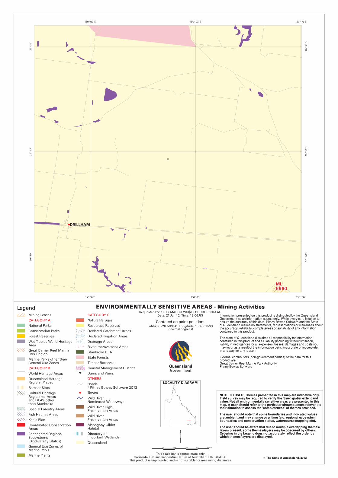

Ecology Assessment Report 46BWR274
Doc Ref: Q-4550-15-RP-001_34 Revision: 0 Page 59 of 61
Approvals, Land and Stakeholder Team, Australia Pacific LNG Upstream Phase 1
Uncontrolled when printed unless issued and stamped Controlled Copy.
9.0 Appendix D: Flora species recorded on Site during field survey Scientific Name Common Name
Acacia debilis -
Acacia decora Pretty Wattle
Acacia harpophylla Brigalow
Acacia ixiophylla -
Acacia leiocalyx Early Flowering Black Wattle
Acacia shirleyi Lancewood
Acacia spectabilis Pilliga Wattle
Agrostis stolonifera Creeping Bent
Allocasuarina luehmannii Bull Oak
Alphitonia excelsa Soap Tree
Angophora floribunda Rough-Barked Apple
Angophora leiocarpa Rusty Gum
Aristida calycina -
Aristida caput-medusae -
Asperula sp. -
Brachyscome whitei -
Bursaria spinosa subsp. spinosa -
Caladenia caerulea Blue Caladenia
Callitris glaucophylla White Cypress Pine
Carissa ovata Currantbush
Casuarina cristata Belah
Cheilanthes sieberi -
Chloris sp. -
Chrysocephalum apiculatum Yellow Buttons
Cymbopogon refractus Barbed-Wire Grass
Dianella sp. -
Dichanthium sericeum -
Dodonaea boroniifolia -
Dodonaea viscosa -
Eragrostis sp. -
Eremophila debilis Winter Apple
Eremophila mitchellii False Sandalwood
Eucalyptus crebra Narrow-Leaved Red Ironbark
Eucalyptus fibrosa Blue-Leaved Ironbark
Eucalyptus moluccana Gum-Topped Box
Eucalyptus populnea Poplar Box
Eucalyptus tereticornis Qld Blue Gum, Forest Red Gum

Ecology Assessment Report 46BWR274
Doc Ref: Q-4550-15-RP-001_34 Revision: 0 Page 60 of 61
Approvals, Land and Stakeholder Team, Australia Pacific LNG Upstream Phase 1
Uncontrolled when printed unless issued and stamped Controlled Copy.
Fimbristylis dichotoma Common Fringe-Rush
Gahnia aspera -
Gonocarpus urceolatus -
Goodenia sp. -
Goodenia gracilis -
Grevillea striata Beefwood
Laxmannia compacta -
Leptospermum polygalifolium Tantoon
Leucopogon biflorus -
Lomandra longifolia -
Opuntia stricta Prickly Pear
Opuntia tomentosa Velvety Tree Pear
Panicum sp. -
Panicum decompositum -
Panicum effusum -
Paspalidium sp. -
Pittosporum angustifolium -
Plantago sp. -
Psydrax odorata -
Solanum ellipticum Potato Bush
Verbena aristigera* Mayne's Pest
*Introduced species

Ecology Assessment Report 46BWR274
Doc Ref: Q-4550-15-RP-001_34 Revision: 0 Page 61 of 61
Approvals, Land and Stakeholder Team, Australia Pacific LNG Upstream Phase 1
Uncontrolled when printed unless issued and stamped Controlled Copy.
10.0 Appendix E: Fauna species recorded on Site during field survey
Type Scientific Name Common Name Observation Methods
Birds Acanthiza reguloides Buff-Rumped Thornbill Seen
Corvus coronoides Australian Raven Seen
Lichenostomus leucotis White-Eared Honeyeater Seen
Manorina melanocephala Noisy Miner Seen