Embed Size (px)
Citation preview
Ecology Assessment Report REPORT
Doc Ref: Q-4530-15-RP-1051 Revision: 0 Page 2 of 34
Business Integrity, Australia Pacific LNG Project
Uncontrolled when printed unless issued and stamped Controlled Copy.
Release Notice
This document is available through the Australia Pacific LNG Project controlled document system
TeamBinder™. The responsibility for ensuring that printed copies remain valid rests with the user. Once
printed, this is an uncontrolled document unless issued and stamped Controlled Copy.
Third-party issue can be requested via the Australia Pacific LNG Project Document Control Group.
Document Conventions
The following terms in this document apply:
Will, shall or must indicate a mandatory course of action
Should indicates a recommended course of action
May or can indicate a possible course of action.
Document Custodian
The custodian of this document is the Australia Pacific LNG Project – Environmental Approvals Manager.
The custodian is responsible for maintaining and controlling changes (additions and modifications) to this
document and ensuring the stakeholders validate any changes made to this document.
Deviations from Document
Any deviation from this document must be approved by the Australia Pacific LNG Project – Environmental
Approvals Manager.
Ecology Assessment Report REPORT
Doc Ref: Q-4530-15-RP-1051 Revision: 0 Page 3 of 34
Business Integrity, Australia Pacific LNG Project
Uncontrolled when printed unless issued and stamped Controlled Copy.
Table of Contents
1. Introduction ........................................................................................... 5
1.1. Scope of Works ............................................................................................. 5
1.2. Definitions & Abbreviations .............................................................................. 5
1.2.1. Definitions................................................................................................. 5
1.2.2. Abbreviations ............................................................................................. 6
1.2.3. Document Revision Table ............................................................................... 6
1.2.4. Document References ................................................................................... 7
2. Site Context ........................................................................................... 9
3. Methodology .......................................................................................... 10
3.1. Desktop and Literature Review ....................................................................... 10
3.2. Field Survey ............................................................................................... 11
3.2.1. Vegetation Community Survey ........................................................................ 11
3.2.2. Habitat Surveys .......................................................................................... 11
3.2.3. Threatened Flora and Fauna Survey .................................................................. 11
3.2.4. Exotic Flora and Fauna Survey ........................................................................ 12
3.2.5. Disturbance Survey...................................................................................... 12
3.2.6. Survey Limitations ...................................................................................... 12
4. Results and Discussions ............................................................................. 13
4.1. Desktop and Literature Review ....................................................................... 13
4.2. Field Survey ............................................................................................... 13
4.2.1. Commonwealth Environmental Matters .............................................................. 13
4.2.2. Queensland Environmental Matters ................................................................... 16
4.2.3. Disturbance .............................................................................................. 19
5. Conclusions ........................................................................................... 20
Appendix A: Site Location and Survey Points .......................................................... 21
Appendix B: Results of EPBC Protected Matters Search Tool ........................................ 22
Appendix C: Wildlife Online Database Search Results ................................................ 23
Appendix D: EHP Mapped Regional Ecosystems ....................................................... 24
Appendix E: EHP Mapping of ESAs and Other Environmental Values on Site ...................... 25
Appendix F: List of Flora and Fauna Species Identified on Site ..................................... 26
Appendix G: Ground Truthed Threatened Ecological Communities ................................ 30
Appendix H: Ground Truthed Regional Ecosystems ................................................... 31
Appendix I: Ground Truthed EPBC Threat Listed Species Present on Site ......................... 32
Appendix J: Ground Truthed NC Act Threat Listed Species Present on Site ...................... 33
Appendix K: Ground Truthed Weeds and Pest Fauna Present on Site .............................. 34
Ecology Assessment Report REPORT
Doc Ref: Q-4530-15-RP-1051 Revision: 0 Page 4 of 34
Business Integrity, Australia Pacific LNG Project
Uncontrolled when printed unless issued and stamped Controlled Copy.
List of Tables
Table 1: Definitions ....................................................................................................... 5
Table 2: Abbreviations .................................................................................................... 6
Table 3: Revision History ................................................................................................. 6
Table 4: Associated Document References ............................................................................ 7
Table 5: Site Context ..................................................................................................... 9
Table 6: Desktop and Literature Review Sources .................................................................. 10
Table 7: Commonwealth Environmental Matters – Field Survey Results ....................................... 14
Table 8: State Environmental Matters – Field Survey Results .................................................... 16
Table 9: Ground Truthed Regional Ecosystems and Regrowth ................................................... 18
Table 10: Pest Flora Recorded on Site ............................................................................... 19
Ecology Assessment Report REPORT
Doc Ref: Q-4530-15-RP-1051 Revision: 0 Page 5 of 34
Business Integrity, Australia Pacific LNG Project
Uncontrolled when printed unless issued and stamped Controlled Copy.
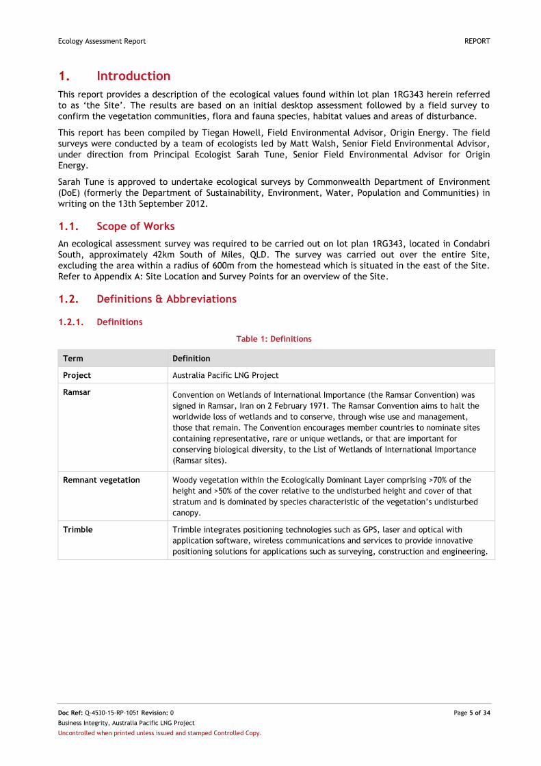
1. Introduction
This report provides a description of the ecological values found within lot plan 1RG343 herein referred
to as ‘the Site’. The results are based on an initial desktop assessment followed by a field survey to
confirm the vegetation communities, flora and fauna species, habitat values and areas of disturbance.
This report has been compiled by Tiegan Howell, Field Environmental Advisor, Origin Energy. The field
surveys were conducted by a team of ecologists led by Matt Walsh, Senior Field Environmental Advisor,
under direction from Principal Ecologist Sarah Tune, Senior Field Environmental Advisor for Origin
Energy.
Sarah Tune is approved to undertake ecological surveys by Commonwealth Department of Environment
(DoE) (formerly the Department of Sustainability, Environment, Water, Population and Communities) in
writing on the 13th September 2012.
1.1. Scope of Works
An ecological assessment survey was required to be carried out on lot plan 1RG343, located in Condabri
South, approximately 42km South of Miles, QLD. The survey was carried out over the entire Site,
excluding the area within a radius of 600m from the homestead which is situated in the east of the Site.
Refer to Appendix A: Site Location and Survey Points for an overview of the Site.
1.2. Definitions & Abbreviations
1.2.1. Definitions
Table 1: Definitions
Term Definition
Project Australia Pacific LNG Project
Ramsar Convention on Wetlands of International Importance (the Ramsar Convention) was
signed in Ramsar, Iran on 2 February 1971. The Ramsar Convention aims to halt the
worldwide loss of wetlands and to conserve, through wise use and management,
those that remain. The Convention encourages member countries to nominate sites
containing representative, rare or unique wetlands, or that are important for
conserving biological diversity, to the List of Wetlands of International Importance
(Ramsar sites).
Remnant vegetation Woody vegetation within the Ecologically Dominant Layer comprising >70% of the
height and >50% of the cover relative to the undisturbed height and cover of that
stratum and is dominated by species characteristic of the vegetation’s undisturbed
canopy.
Trimble Trimble integrates positioning technologies such as GPS, laser and optical with
application software, wireless communications and services to provide innovative
positioning solutions for applications such as surveying, construction and engineering.
Ecology Assessment Report REPORT
Doc Ref: Q-4530-15-RP-1051 Revision: 0 Page 6 of 34
Business Integrity, Australia Pacific LNG Project
Uncontrolled when printed unless issued and stamped Controlled Copy.
1.2.2. Abbreviations
The following abbreviations are found throughout this report.
Table 2: Abbreviations
Abbreviation Description
BoM Bureau of Meteorology
CSG Coal Seam Gas
DAFF Department of Agriculture, Fisheries and Forestry (Qld) (formerly DPI)
DME Department of Mines and Energy (Qld)
DoE Department of Environment (Cth)
DSEWPaC Department of Sustainability, Environment, Water, Population and Communities (C’th)
EH Essential Habitat
EHP Department of Environment and Heritage Protection (Qld) (formally DERM and EPA)
EPBC Environmental Protection Biodiversity and Conservation Act 1999 (C’th)
ESA Environmentally Sensitive Area
EVNT Endangered, Vulnerable or Near Threatened fauna as listed under the NC Act.
GIS Geographic Information System
GPS Global Positioning System
GTRE Ground Truthed Regional Ecosystem
LC Flora and fauna which has a conservation status of ‘Least Concern’ under the Nature
Conservation Act 1992
LNG Liquefied Natural Gas
LP Act Land Protection (Pest and Stock Route Management) Act 200 (Qld).
MNES Matters of National Environmental Significance
NC Act Nature Conservation Act 1992 (Qld)
NCaP Vegetation which has a Biodiversity status of ‘No Concern at Present’
RE Regional Ecosystem
REDD Regional Ecosystem Description Database
SLC Special Least Concern flora and fauna
TEC Threatened Ecological Communities
WoNS Weed of National Significance
1.2.3. Document Revision Table
Table 3: Revision History
Revision Date Description
Ecology Assessment Report REPORT
Doc Ref: Q-4530-15-RP-1051 Revision: 0 Page 7 of 34
Business Integrity, Australia Pacific LNG Project
Uncontrolled when printed unless issued and stamped Controlled Copy.
1.2.4. Document References
The following documents are referred to throughout this report.
Table 4: Associated Document References
Document Number Title
Accad, A; Neldner, V.J; Wilson, B. A; and Niehus, R.E. (2012) Remnant Vegetation in Queensland. Analysis of remnant vegetation 1997-2009, including regional ecosystem information. (Queensland Department of Science, Information Technology, Innovation and the Arts: Brisbane). http://www.ehp.qld.gov.au/ecosystems/remnant-vegetation/index.html#subregion_and_bioregion_analysis_of
BoM (2014) Bureau of Meteorology - Climate statistics for Australian Locations. Australian Government, Canberra. http://www.bom.gov.au/climate/averages/tables/cw_042023.shtml
DME (2008).Queensland Geological Mapping (polygonised vector) Data: Regional & 1:100 00 Sheet areas (DVD). Department of Mines and Energy, Queensland.
DNRM (2014a) Regional Ecosystem and Remnant Map—version 8.1 for the purpose of the Vegetation Management Act 1999. The Department of Natural Resources and Mines, Brisbane. http://www.dnrm.qld.gov.au/land/vegetation-management/vegetation-maps/vegetation-map-request Accessed 2/11/2014
DoE (2013a) Protected Matters Search Tool. Department of the Environment. Canberra. http://www.environment.gov.au/epbc/pmst/index.html Accessed 2/11/2014
DoE (2013b) Environmental Protection and Biodiversity Conservation Act 1999, Department of Sustainability, Environment, Water, Population and Communities. http://www.environment.gov.au/epbc/about/index.html
DSEWPaC (2009a) Species Profile and Threats Database (EPBC Act List of Threatened Ecological Communities). Department of the Environment, Water, Heritage and the Arts, Canberra. http://www.environment.gov.au/cgi-bin/sprat/public/publiclookupcommunities.pl
EHP (2012a). Regional Ecosystem Land Zone definitions, Department of Environment and Heritage Protection, Brisbane. http://www.ehp.qld.gov.au/ecosystems/biodiversity/regional-ecosystems/land_zone_definitions.html
EHP (2012b) Wildlife Online. Department of Environment and Heritage Protection, Brisbane. http://www.ehp.qld.gov.au/wildlife/wildlife-online/ Accessed 2/11/2014
EHP (2012c) Map of Referable Wetlands. Department of Environment and Resource Management, Brisbane. http://www.ehp.qld.gov.au/ecosystems/wetlands/referable-wetlands-maps.html Accessed 2/11/2014
EHP (2012d) Regional Ecosystem Description Database (REDD). http://www.ehp.qld.gov.au/ecosystems/biodiversity/regional-ecosystems/index.php
EHP (2012e) Essential Habitat Map for the purpose of the Vegetation Management Act 1999. The Department of Environment and Resource Management, Brisbane. http://www.ehp.qld.gov.au/licences-permits/maps_of_environmentally_sensitive_areas.php Accessed 2/11/2014
Eyre, T.J., Kelly, A.L, Neldner, V.J., Wilson, B.A., Ferguson, D.J., Laidlaw, M.J. and Franks, A.J. (2011).BioCondition: A Condition Assessment Framework for Terrestrial Biodiversity in Queensland. Assessment Manual. Version 2.1.Department of Environment and Resource Management, Biodiversity and Ecosystem Sciences, Brisbane.
Hando, R. and Hando, V. (1997) Going Bush With Chinchilla Nats. Second Edition. Chinchilla Field Naturalists’ Club, Chinchilla.
Neldner, V.J., Wilson, B. A., Thompson, E.J. and Dillewaard, H.A. (2012). Methodology for Survey and Mapping of Regional Ecosystems and Vegetation Communities in Queensland. Version 3.2.Updated August 2012. Queensland Herbarium, Environmental Protection Agency, Brisbane.128 pp.
NSW (2011) Weeds of National Significance, National Weeds Strategy. Australian Government. http://www.weeds.org.au/ or http://www.daff.qld.gov.au/4790_7046.htm
Queensland Parliamentary Counsel (2002) Land Protection (Pest and Stock Route Management) Act, Queensland Government, Brisbane.

Ecology Assessment Report REPORT
Doc Ref: Q-4530-15-RP-1051 Revision: 0 Page 8 of 34
Business Integrity, Australia Pacific LNG Project
Uncontrolled when printed unless issued and stamped Controlled Copy.
Document Number Title
http://www.legislation.qld.gov.au/legisltn/current/l/landprpsrma02.pdf
Queensland Parliamentary Counsel, (2000) Water Act, Queensland Government, Brisbane. http://www.legislation.qld.gov.au/legisltn/current/w/watera00.pdf
Queensland Parliamentary Counsel, (2006) Nature Conservation (Wildlife) Regulation, Queensland Government, Brisbane. http://www.legislation.qld.gov.au/LEGISLTN/CURRENT/N/NatureConWiR06.pdf
GISWR_23253_IFPSL_RevA
Preliminary GIS mapping suite
Q-LNG01-15-MP-0109 Australian Pacific LNG (2011) Environmental Constraints Planning and Field Development Protocol.
Ecology Assessment Report REPORT
Doc Ref: Q-4530-15-RP-1051 Revision: 0 Page 9 of 34
Business Integrity, Australia Pacific LNG Project
Uncontrolled when printed unless issued and stamped Controlled Copy.
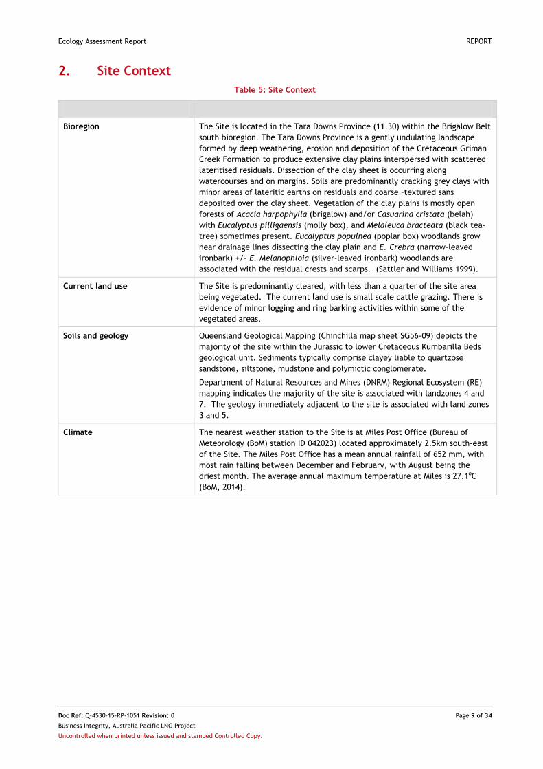
2. Site Context
Table 5: Site Context
Bioregion The Site is located in the Tara Downs Province (11.30) within the Brigalow Belt
south bioregion. The Tara Downs Province is a gently undulating landscape
formed by deep weathering, erosion and deposition of the Cretaceous Griman
Creek Formation to produce extensive clay plains interspersed with scattered
lateritised residuals. Dissection of the clay sheet is occurring along
watercourses and on margins. Soils are predominantly cracking grey clays with
minor areas of lateritic earths on residuals and coarse –textured sans
deposited over the clay sheet. Vegetation of the clay plains is mostly open
forests of Acacia harpophylla (brigalow) and/or Casuarina cristata (belah)
with Eucalyptus pilligaensis (molly box), and Melaleuca bracteata (black tea-
tree) sometimes present. Eucalyptus populnea (poplar box) woodlands grow
near drainage lines dissecting the clay plain and E. Crebra (narrow-leaved
ironbark) +/- E. Melanophloia (silver-leaved ironbark) woodlands are
associated with the residual crests and scarps. (Sattler and Williams 1999).
Current land use The Site is predominantly cleared, with less than a quarter of the site area
being vegetated. The current land use is small scale cattle grazing. There is
evidence of minor logging and ring barking activities within some of the
vegetated areas.
Soils and geology Queensland Geological Mapping (Chinchilla map sheet SG56-09) depicts the
majority of the site within the Jurassic to lower Cretaceous Kumbarilla Beds
geological unit. Sediments typically comprise clayey liable to quartzose
sandstone, siltstone, mudstone and polymictic conglomerate.
Department of Natural Resources and Mines (DNRM) Regional Ecosystem (RE)
mapping indicates the majority of the site is associated with landzones 4 and
7. The geology immediately adjacent to the site is associated with land zones
3 and 5.
Climate The nearest weather station to the Site is at Miles Post Office (Bureau of
Meteorology (BoM) station ID 042023) located approximately 2.5km south-east
of the Site. The Miles Post Office has a mean annual rainfall of 652 mm, with
most rain falling between December and February, with August being the
driest month. The average annual maximum temperature at Miles is 27.1oC
(BoM, 2014).
Ecology Assessment Report REPORT
Doc Ref: Q-4530-15-RP-1051 Revision: 0 Page 10 of 34
Business Integrity, Australia Pacific LNG Project
Uncontrolled when printed unless issued and stamped Controlled Copy.
3. Methodology
The methodology employed in compilation of this Ecological Assessment Report consisted of:
A desktop and literature review of ecological databases and literature sources as direct
references for the survey undertaken
A field survey of the Site
An explanation of these activities is outlined in this section.
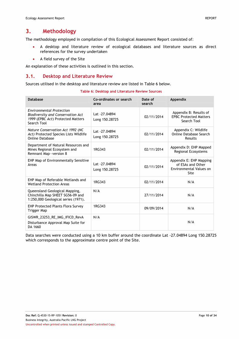
3.1. Desktop and Literature Review
Sources utilised in the desktop and literature review are listed in Table 6 below.
Table 6: Desktop and Literature Review Sources
Database Co-ordinates or search area
Date of search
Appendix
Environmental Protection Biodiversity and Conservation Act 1999 (EPBC Act) Protected Matters Search Tool
Lat -27.04894
Long 150.28725 02/11/2014
Appendix B: Results of EPBC Protected Matters
Search Tool
Nature Conservation Act 1992 (NC Act) Protected Species Lists Wildlife Online Database
Lat -27.04894
Long 150.28725 02/11/2014
Appendix C: Wildlife Online Database Search
Results
Department of Natural Resources and Mines Regional Ecosystem and Remnant Map—version 8
1RG343 02/11/2014 Appendix D: EHP Mapped
Regional Ecosystems
EHP Map of Environmentally Sensitive Areas Lat -27.04894
Long 150.28725 02/11/2014
Appendix E: EHP Mapping of ESAs and Other
Environmental Values on Site
EHP Map of Referable Wetlands and Wetland Protection Areas
1RG343 02/11/2014 N/A
Queensland Geological Mapping, Chinchilla Map SHEET SG56-09 and 1:250,000 Geological series (1971).
N/A 27/11/2014 N/A
EHP Protected Plants Flora Survey Trigger Map
1RG343 09/09/2014 N/A
GISWR_23253_RE_IMG_IFICD_RevA
Disturbance Approval Map Suite for DA 1660
N/A
N/A
Data searches were conducted using a 10 km buffer around the coordinate Lat -27.04894 Long 150.28725
which corresponds to the approximate centre point of the Site.
Ecology Assessment Report REPORT
Doc Ref: Q-4530-15-RP-1051 Revision: 0 Page 11 of 34
Business Integrity, Australia Pacific LNG Project
Uncontrolled when printed unless issued and stamped Controlled Copy.
3.2. Field Survey
Ecological surveys were conducted in accordance with:
The Methodology for Survey and Mapping of Regional Ecosystems and Vegetation Communities in
Queensland (Neldner et al. 2005)
In line with the methodology described in the Environmental Constraints Planning and Field
Development Protocol (Q-LNG01-15-MP-0109, Australia Pacific LNG 2011).
Field surveys were undertaken between the 28th November 2014 and the 2nd December 2014.
3.2.1. Vegetation Community Survey
Baseline botanical surveys were undertaken to describe dominant flora and vegetation community
structure throughout the survey site. Botanical surveys were consistent with the tertiary level of data
collection as described in Neldner et al. (2012).
The vegetation community surveys were undertaken within 50m x 10m plots for the purpose of typifying
the vegetation community under assessment. Vegetation community data was entered into the data
fields provided by the Trimble data capture system. A total of 4 formal vegetation community surveys
were undertaken within the Site. Ground-truthing of the DNRM RE designation (DNRM 2014) at and
surrounding the Site was undertaken via quaternary level and random meanders transect assessments, as
defined by Neldner et al. (2012).
The locations of the vegetation community survey sites are presented in Appendix A: Site Location and
Survey Points.
Relative abundance data was collected for each stratum within the community as per the methodology
described in the Environmental Constraints Planning and Field Development Protocol (Q-LNG01-15-MP-
0109 Australia Pacific LNG (2011)), as presented by the vegetation structure point data sheet of the
Trimble unit. Representative photo(s) were taken of the subject vegetation community via the Trimble
unit or camera. Photo aspect data was recorded.
Vegetation community polygons were verified in accordance with Queensland regional ecosystem
(biodiversity status) (DNRM 2014) and EPBC threatened ecological community (TEC) criteria (DSEWPaC
2009).
3.2.2. Habitat Surveys
Habitat surveys were undertaken in conjunction with vegetation community survey within the 50m x 10m
quadrant. A total of 4 formal habitat surveys were undertaken across the Site (Appendix A: Site Location
and Survey Points).
Within each habitat survey, a range of habitat features were recorded on the relevant Trimble data
sheet. Where deemed appropriate, representative photo(s) were taken of the given habitat patch via the
Trimble unit. Photo aspect data is entered into the relevant data sheet.
3.2.3. Threatened Flora and Fauna Survey
Threat-listed species are those listed under the EPBC Act 1999 and the Nature Conservation (Wildlife)
Regulation 2006.
Targeted threat-listed flora searches were undertaken for species highlighted by the database and
literature review. Searches were undertaken based on incidental field observations of high quality
habitat, the identification of distinct ecological features through the preliminary desktop and literature
review, or within the vicinity of a vegetation community survey/habitat feature plots where field
ecologists deemed the given area to be of sufficient potential value to a threatened species to warrant
such a search.
Fauna species were recorded opportunistically throughout the survey area.
Any observations of threatened species (whether within search areas or opportunistically) were recorded
using the Trimble data capture system.
Ecology Assessment Report REPORT
Doc Ref: Q-4530-15-RP-1051 Revision: 0 Page 12 of 34
Business Integrity, Australia Pacific LNG Project
Uncontrolled when printed unless issued and stamped Controlled Copy.
3.2.4. Exotic Flora and Fauna Survey
Presence and abundance of declared flora and fauna as defined by the Land Protection (Pest and Stock
Route Management) Act 2002 (LP Act), were recorded at the time of the survey both within survey plots
and opportunistically while traversing the Site. Exotic flora and fauna species were entered into the
Trimble data capture system when encountered.
3.2.5. Disturbance Survey
Evidence of disturbance at survey sites was recorded for type, severity and estimated time of most
recent occurrence. The recording of disturbance was also conducted at opportunistic levels where
appropriate.
3.2.6. Survey Limitations
A number of factors are considered likely to influence survey results for particular species or species
groups. These factors include, but are not limited to:
Timing (seasons) and duration of the survey period
Weather conditions in the preceding seasons and immediately prior to the survey
Restricted spatial area of the habitats within the Site
Due to the above-listed items, the surveys undertaken may not provide a true indication of seasonal
habitat utilisation by fauna species within the Site. Some cryptic flora species may only be detected
during particular flowering periods. The field investigations undertaken were limited to passive
techniques (e.g. no live trapping) and were limited to the summer season. Additional survey effort would
be required to provide a more comprehensive inventory of species, both threatened and common.
Ecology Assessment Report REPORT
Doc Ref: Q-4530-15-RP-1051 Revision: 0 Page 13 of 34
Business Integrity, Australia Pacific LNG Project
Uncontrolled when printed unless issued and stamped Controlled Copy.
4. Results and Discussions
This section includes the results of the database and literature review. Some information is contained in
the appendices and is referenced below.
4.1. Desktop and Literature Review
Results of the desktop and literature review can be found in Appendices B - E, as listed in Table 6.
4.2. Field Survey
Results of field surveys are detailed in the following sections. A comprehensive list of flora and fauna
species identified during the field survey is included in Appendix F: List of Flora and Fauna Species
Identified on Site.
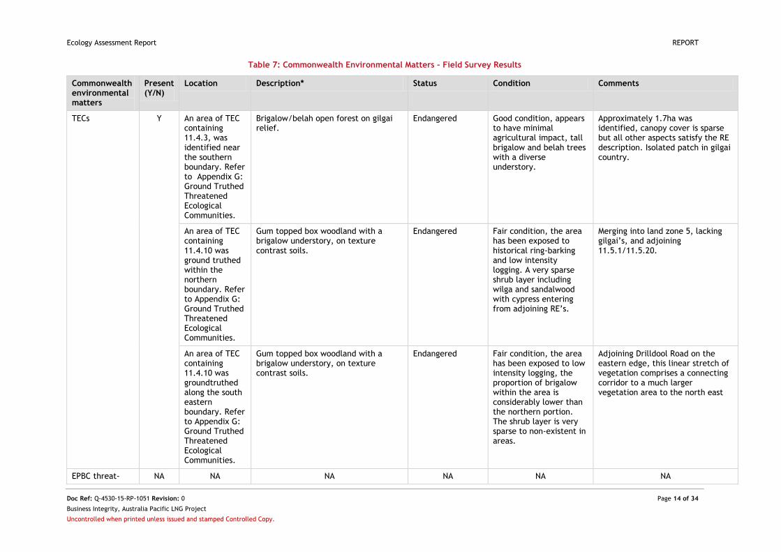
4.2.1. Commonwealth Environmental Matters
Field survey results for Commonwealth environmental matters (Matters of National Environmental
Significance (MNES), TECs, threat-listed species) are outlined in Table 7.
Three areas meeting TEC listing criteria were ground-truthed within the Site; all qualified as the
Brigalow (Acacia harpophylla dominant and co-dominant) TEC, with two areas classified as RE 11/4/10,
and a small area in the southern portion of the Site identified as 11.4.3.
One Migratory (rainbow bee-eater (Merops ornatus)) and three Marine species were identified within the
survey area; the rainbow bee-eater (Merops ornatus), the black-faced cuckoo shrike (Coracina
novaehollandiae), the magpie lark (Grallina cyanoleuca) and the nankeen kestrel (Falco cenchroides).
Ecology Assessment Report REPORT
Doc Ref: Q-4530-15-RP-1051 Revision: 0 Page 14 of 34
Business Integrity, Australia Pacific LNG Project
Uncontrolled when printed unless issued and stamped Controlled Copy.
Table 7: Commonwealth Environmental Matters – Field Survey Results
Commonwealth environmental matters
Present (Y/N)
Location Description* Status Condition Comments
TECs Y An area of TEC containing 11.4.3, was identified near the southern boundary. Refer to Appendix G: Ground Truthed Threatened Ecological Communities.
Brigalow/belah open forest on gilgai relief.
Endangered Good condition, appears to have minimal agricultural impact, tall brigalow and belah trees with a diverse understory.
Approximately 1.7ha was identified, canopy cover is sparse but all other aspects satisfy the RE description. Isolated patch in gilgai country.
An area of TEC containing 11.4.10 was ground truthed within the northern boundary. Refer to Appendix G: Ground Truthed Threatened Ecological Communities.
Gum topped box woodland with a brigalow understory, on texture contrast soils.
Endangered Fair condition, the area has been exposed to historical ring-barking and low intensity logging. A very sparse shrub layer including wilga and sandalwood with cypress entering from adjoining RE’s.
Merging into land zone 5, lacking gilgai’s, and adjoining 11.5.1/11.5.20.
An area of TEC containing 11.4.10 was groundtruthed along the south eastern boundary. Refer to Appendix G: Ground Truthed Threatened Ecological Communities.
Gum topped box woodland with a brigalow understory, on texture contrast soils.
Endangered Fair condition, the area has been exposed to low intensity logging, the proportion of brigalow within the area is considerably lower than the northern portion. The shrub layer is very sparse to non-existent in areas.
Adjoining Drilldool Road on the eastern edge, this linear stretch of vegetation comprises a connecting corridor to a much larger vegetation area to the north east
EPBC threat- NA NA NA NA NA NA

Ecology Assessment Report REPORT
Doc Ref: Q-4530-15-RP-1051 Revision: 0 Page 15 of 34
Business Integrity, Australia Pacific LNG Project
Uncontrolled when printed unless issued and stamped Controlled Copy.
Commonwealth environmental matters
Present (Y/N)
Location Description* Status Condition Comments
listed flora
EPBC threat-listed fauna
NA NA NA NA NA NA
Migratory species
Y This species was observed in two locations on the Site; both were vegetation along edges of cleared areas. Refer to Appendix I: Ground Truthed EPBC Threat Listed Species Present on Site.
rainbow bee-eater (Merops ornatus)
Migratory NA NA
Marine species Y These species were observed in varied habitats within the Site. Refer to Appendix I: Ground Truthed EPBC Threat Listed Species Present on Site.
rainbow bee-eater (Merops ornatus)
black-faced cuckoo shrike (Coracina novaehollandiae)
magpie lark (Grallina cyanoleuca)
nankeen kestrel (Falco cenchroides)
Marine NA NA
*Status taken from DoE 2014
Ecology Assessment Report REPORT
Doc Ref: Q-4530-15-RP-1051 Revision: 0 Page 16 of 34
Business Integrity, Australia Pacific LNG Project
Uncontrolled when printed unless issued and stamped Controlled Copy.
4.2.2. Queensland Environmental Matters
4.2.2.1. Field Survey Results
Field survey results for State environmental matters (EVNT etc) are outlined in Table 8.
Table 8: State Environmental Matters – Field Survey Results
State environmental
matters
Present
(Y/N)
Location Description* Status* Comments
Endangered regional
ecosystems
Y Near to the
southern
boundary, mid
property
11.4.3 Acacia harpophylla and/or Casuarina
cristata shrubby open forest on Cainozoic
clay plains.
Endangered Approximately 1.7ha was identified, canopy cover is sparse but all other aspects satisfy the RE description. Isolated patch in gilgai country.
Small patch
within northern
boundary and
along eastern
boundary
11.4.10 Eucalyptus populnea or E.
woollsiana, Acacia harpophylla, Casuarina
cristata open forest to woodland on margins
of Cainozoic clay plains.
Endangered Fringing remnants merging with
11.5.1/11.5.20. Gilgai relief is
replaced by Land Zone 5
characteristics.
Linear patch
extending into
the road reserve
along the south
eastern
boundary
11.4.10 Eucalyptus populnea or E.
woollsiana, Acacia harpophylla, Casuarina
cristata open forest to woodland on margins
of Cainozoic clay plains.
Endangered Remnants entering Site from the
road reserve. Saved from historic,
agricultural due to the lighter soils.
Good examples of large, mature
Eucalyptus microcarpa.
Of concern regional
ecosystems
NA NA NA NA NA
NC Act listed flora
(EVNT)
NA NA NA NA NA
NC Act listed fauna
(EVNT)
NA NA NA NA NA
Special Least Concern
Flora
Y Refer to
Appendix J:
Ground Truthed
NC Act Threat
Santalum lanceolatum (sandalwood)
Cymbidium canaliculatum (black orchid)
Cheilanthes sieberi (mulga fern)
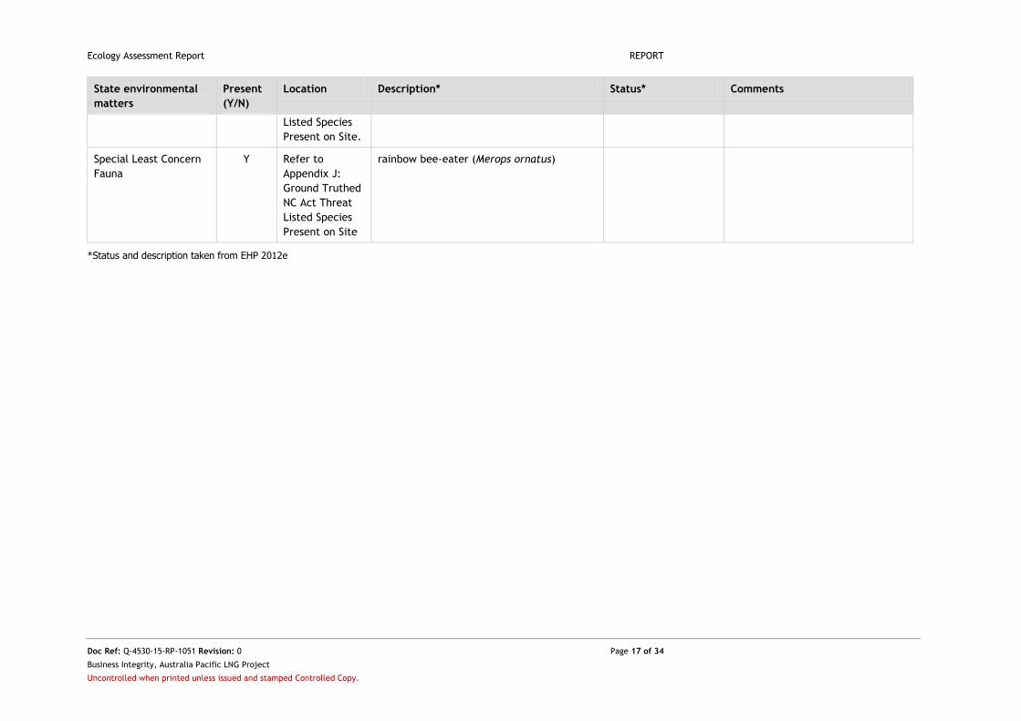
Ecology Assessment Report REPORT
Doc Ref: Q-4530-15-RP-1051 Revision: 0 Page 17 of 34
Business Integrity, Australia Pacific LNG Project
Uncontrolled when printed unless issued and stamped Controlled Copy.
State environmental
matters
Present
(Y/N)
Location Description* Status* Comments
Listed Species
Present on Site.
Special Least Concern
Fauna
Y Refer to
Appendix J:
Ground Truthed
NC Act Threat
Listed Species
Present on Site
rainbow bee-eater (Merops ornatus)
*Status and description taken from EHP 2012e
Ecology Assessment Report REPORT
Doc Ref: Q-4530-15-RP-1051 Revision: 0 Page 18 of 34
Business Integrity, Australia Pacific LNG Project
Uncontrolled when printed unless issued and stamped Controlled Copy.
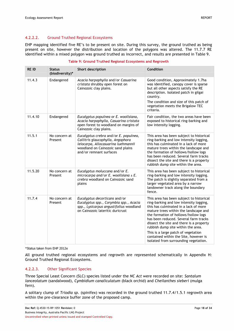
4.2.2.2. Ground Truthed Regional Ecosystems
EHP mapping identified five RE’s to be present on site. During this survey, the ground truthed as being
present on site, however the distribution and location of the polygons was altered. The 11.7.7 RE
identified within a mixed polygon was ground truthed as incorrect, and results are presented in Table 9.
Table 9: Ground Truthed Regional Ecosystems and Regrowth
RE ID Status (biodiversity)*
Short description Condition
11.4.3 Endangered Acacia harpophylla and/or Casuarina cristata shrubby open forest on Cainozoic clay plains.
Good condition, Approximately 1.7ha was identified, canopy cover is sparse but all other aspects satisfy the RE description. Isolated patch in gilgai country.
The condition and size of this patch of vegetation meets the Brigalow TEC criteria.
11.4.10 Endangered Eucalyptus populnea or E. woollsiana, Acacia harpophylla, Casuarina cristata open forest to woodland on margins of Cainozoic clay plains.
Fair condition, the two areas have been exposed to historical ring-barking and low intensity logging.
11.5.1 No concern at Present
Eucalyptus crebra and/or E. populnea, Callitris glaucophylla, Angophora leiocarpa, Allocasuarina luehmannii woodland on Cainozoic sand plains and/or remnant surfaces
This area has been subject to historical ring-barking and low intensity logging, this has culminated in a lack of more mature trees within the landscape and the formation of hollows/hollow logs has been reduced. Several farm tracks dissect the site and there is a property rubbish dump site within the area.
11.5.20 No concern at Present
Eucalyptus moluccana and/or E. microcarpa and/or E. woollsiana ± E. crebra woodland on Cainozoic sand plains
This area has been subject to historical ring-barking and low intensity logging. The patch is slightly separated from a larger vegetated area by a narrow landowner track along the boundary fence.
11.7.4 No concern at Present
Eucalyptus decorticans and/or Eucalyptus spp., Corymbia spp., Acacia spp., Lysicarpus angustifolius woodland on Cainozoic lateritic duricrust
This area has been subject to historical ring-barking and low intensity logging, this has culminated in a lack of more mature trees within the landscape and the formation of hollows/hollow logs has been reduced. Several farm tracks dissect the site and there is a property rubbish dump site within the area.
This is a large patch of vegetation contained within the Site, however is isolated from surrounding vegetation.
*Status taken from EHP 2012e
All ground truthed regional ecosystems and regrowth are represented schematically in Appendix H:
Ground Truthed Regional Ecosystems.
4.2.2.3. Other Significant Species
Three Special Least Concern (SLC) species listed under the NC Act were recorded on site: Santalum
lanceolatum (sandalwood), Cymbidium canaliculatum (black orchid) and Cheilanthes sieberi (mulga
fern).
A solitary clump of Triodia sp. (spinifex) was recorded in the ground truthed 11.7.4/1.5.1 regrowth area
within the pre-clearance buffer zone of the proposed camp.
Ecology Assessment Report REPORT
Doc Ref: Q-4530-15-RP-1051 Revision: 0 Page 19 of 34
Business Integrity, Australia Pacific LNG Project
Uncontrolled when printed unless issued and stamped Controlled Copy.
Three yellow tailed black cockatoos were sighted foraging amongst E. Microcarpa within remnant
11.4.10 along the eastern boundary.
Appendix J: Ground Truthed NC Act Threat Listed Species Present on Site.
4.2.2.4. Other Environmental Values
The large, deep gilgai's covering much of the Site hold significant habitat value, and the scattered
regrowth vegetation within these cleared areas provides suitable refuge for many avifauna. The
remaining vegetation patches alongside the cleared paddocks provides habitat for foraging avifauna as
displayed with the rainbow bee-eater.
4.2.2.5. Weeds and Pests
Distribution of Weeds of National Significance (WoNS), Class 1, 2 and 3 species declared under the LP Act
and pest fauna on site has been mapped based on field survey results. Appendix K: Ground Truthed
Weeds and Pest Fauna Present on Site is a schematic of the field surveyed weeds and pests.
Pest flora and fauna encountered during the field survey are listed in Table 10.
Table 10: Pest Flora Recorded on Site
Scientific Name Common Name Status* Area of Occurrence
Opuntia tomentosa velvety tree pear WoNS and LP Act Class 2
Low densities across Site, appeared to be less dense in certain cleared paddocks where the landowner has been actively managing the plant.
Opuntia stricta prickly pear WoNS and LP Act Class 2
Very low densities across Site, appeared to be less dense in certain cleared paddocks where the landowner has been actively managing the plant.
*Status taken from LP Act/DoE 2014
4.2.3. Disturbance
The Site has been extensively cleared for agricultural purposes and is currently experiencing severe
drought conditions with remaining stock still grazing the majority of the property. A homestead and
associated infrastructure is situated within the south east corner of the property, landowner tracks
dissect the Site.
There is evidence of low intensity logging and ring barking within the vegetated areas of the Site. There
is a rubbish dump site within the 11.7.4/11.5.1 polygon located in the north east section of the Site.
Observed erosion was minimal, with the Site being relatively flat and the majority of soil types being not
susceptible to erosion.
Origin Energy CSG activities exist on Site, these include an exploration and appraisal well Conabri 10 and
associated infrastructure, near to the south west corner; and a Condabri monitoring wellsite MB5-G and
MB6-S and associated infrastructure in the north east corner of the Site.
Ecology Assessment Report REPORT
Doc Ref: Q-4530-15-RP-1051 Revision: 0 Page 20 of 34
Business Integrity, Australia Pacific LNG Project
Uncontrolled when printed unless issued and stamped Controlled Copy.
5. Conclusions
The Site was almost entirely cleared for agricultural purposes with scattered regrowth vegetation. The
vegetated areas were all in fair condition. Key environmental and ecological values identified within the
survey area are:
Three areas of ground-truthed remnant vegetation in the northern, southern and
south-eastern sections of the Site qualifying as the Brigalow TEC; two areas consistent
with Endangered RE 11.4.10, and one area consistent with Endangered RE 11.4.3.
Remnant vegetation consistent with No Concern at Present REs 11.5.1, 11.5.20 and
11.7.4 represented the limited vegetation on the Site.
A rainbow bee-eater (Merops ornatus), black-faced cuckoo shrike (Coracina
novaehollandiae), magpie lark (Grallina cyanoleuca) and nankeen kestrel (Falco
cenchroides) – EPBC Act Marine and Migratory species were observed within the Site.
Three Special Least Concern flora species; Santalum lanceolatum (sandalwood),
Cymbidium canaliculatum (black orchid) and Cheilanthes sieberi (mulga fern) were
observed scattered across the Site.
A low density population of Opuntia tomentosa and Opuntia stricta scattered
throughout the Site. Both species are Class 2 declared plants and WoNS.
Evidence of wild pig (Sus scrofa), a Class 2 pest fauna species were observed in several
areas within the Site.
A number of habitat features such as scattered timber, habitat trees (limited), stags,
bird nests and loose bark identified evenly-spread throughout the remnant vegetation
within the Site.
Agricultural clearing, low intensity logging and ring barking were the primary disturbance features
identified within the survey area.
It is recommended that the findings in this report are considered during detailed development planning
such that disturbance to the ecological values of the site and locality may be avoided wherever
practical. Where disturbance is unavoidable, impact mitigation measures are to be implemented in
accordance with the approved site environmental management plan and regulatory approval conditions.

Ecology Assessment Report REPORT
Doc Ref: Q-4530-15-RP-1051 Revision: 0 Page 21 of 34
Business Integrity, Australia Pacific LNG Project
Uncontrolled when printed unless issued and stamped Controlled Copy.
Appendix A: Site Location and Survey Points
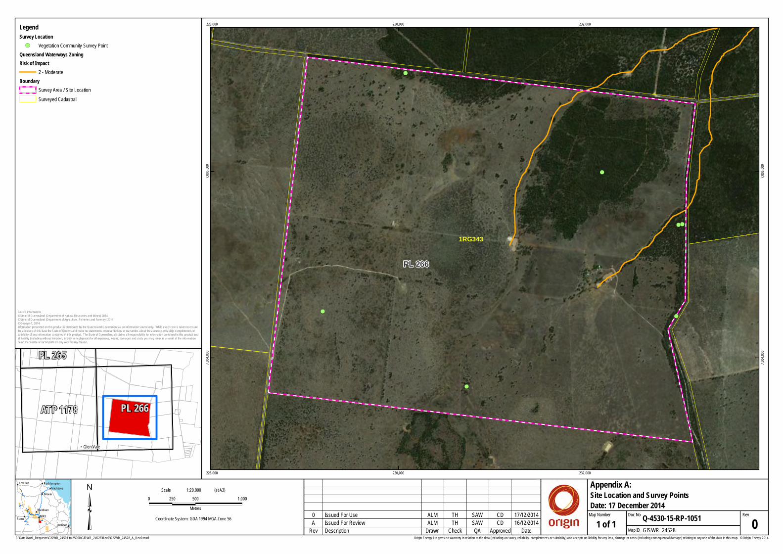
S:\Data\Work_Requests\GISWR_24501 to 25000\GISWR_24528\Rev0\GISWR_24528_A_Rev0.mxd
³ 0 500 1,000250Metres
Coordinate System: GDA 1994 MGA Zone 56
Origin Energy Ltd gives no warranty in relation to the data (including accuracy, reliability, completeness or suitability) and accepts no liability for any loss, damage or costs (including consequential damage) relating to any use of the data in this map. © Origin Energy 2014
!(
!(
!(
!(
!(
!(
!(
PL 266
1RG343
228,000
228,000
230,000
230,000
232,000
232,000
7,004,
000
7,004,
000
7,006,
000
7,006,
000
ALM SAWTH CD
1:20,000Scale (at A3)
16/12/2014Description GISWR_24528Check Map IDDrawn QA Approved 1 of 1
Site Location and Survey Points
Rev Date
RevQ-4530-15-RP-1051
Appendix A:
Map Number Doc NoIssued For Review 0A
0 17/12/2014Issued For Use
SAW
CD
TH
ALM
Date: 17 December 2014
!
!
!
!!
!
!
!
Roma Miles
Biloela
Emerald
Wandoan
Brisbane
GladstoneRockhampton
Source Information:© State of Queensland (Department of Natural Resources and Mines) 2014© State of Queensland (Department of Agriculture, Fisheries and Forestry) 2014© Geoeye-1, 2014Information presented on this product is distributed by the Queensland Government as an information source only. While every care is taken to ensurethe accuracy of this data the State of Queensland make no statements, representations or warranties about the accuracy, reliability, completeness orsuitability of any information contained in this product. The State of Queensland disclaims all responsibility for information contained in this product andall liability (including without limitation, liability in negligence) for all expenses, losses, damages and costs you may incur as a result of the informationbeing inaccurate or incomplete on any way for any reason.
!! Glen Vale
ATP 1178
PL 265
PL 266
LegendSurvey Location !( Vegetation Community Survey Point
Queensland Waterways ZoningRisk of Impact
2 - ModerateBoundary
Survey Area / Site Location Surveyed Cadastral

Ecology Assessment Report REPORT
Doc Ref: Q-4530-15-RP-1051 Revision: 0 Page 22 of 34
Business Integrity, Australia Pacific LNG Project
Uncontrolled when printed unless issued and stamped Controlled Copy.
Appendix B: Results of EPBC Protected Matters Search Tool
The search of the EBPC protected matters database was carried out on 02/11/2014.
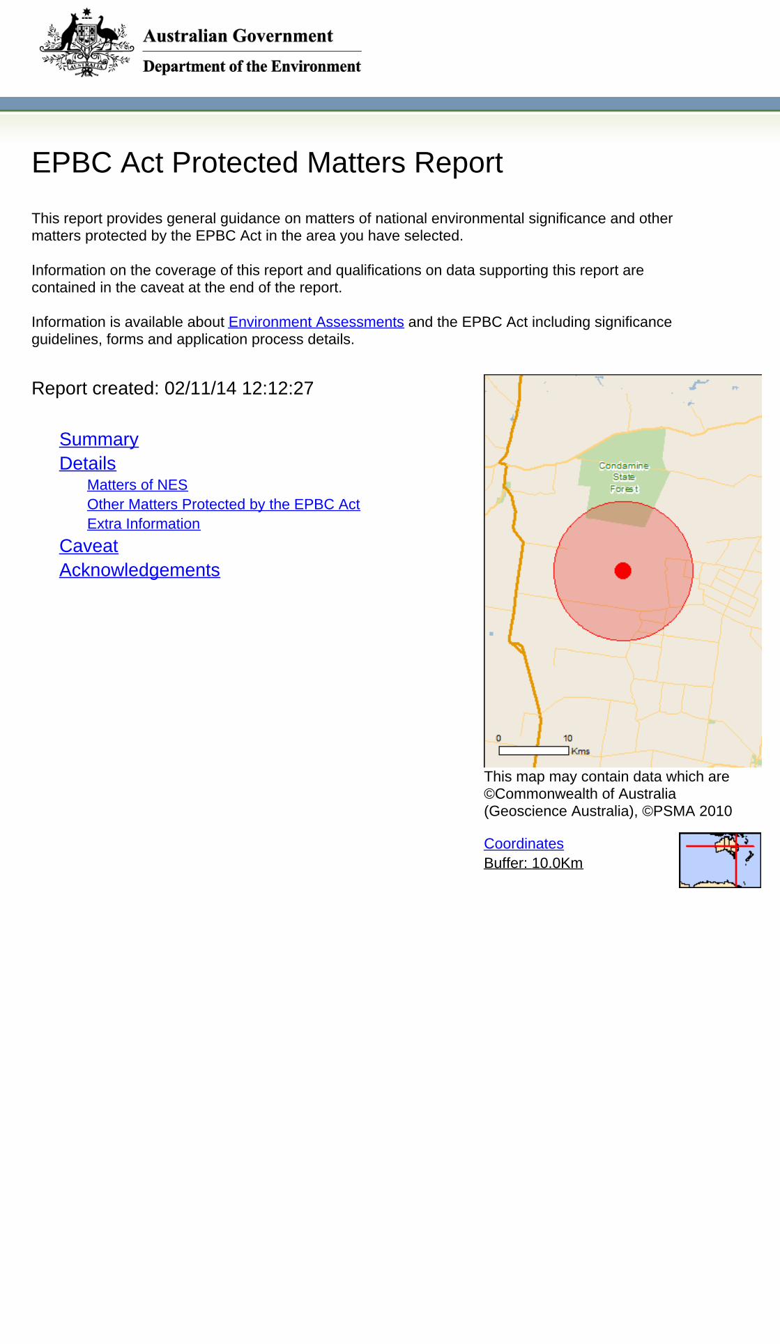
EPBC Act Protected Matters Report
This report provides general guidance on matters of national environmental significance and othermatters protected by the EPBC Act in the area you have selected.
Information on the coverage of this report and qualifications on data supporting this report arecontained in the caveat at the end of the report.
Information is available about Environment Assessments and the EPBC Act including significanceguidelines, forms and application process details.
Other Matters Protected by the EPBC Act
Acknowledgements
Buffer: 10.0Km
Matters of NES
Report created: 02/11/14 12:12:27
Coordinates
This map may contain data which are©Commonwealth of Australia(Geoscience Australia), ©PSMA 2010
CaveatExtra Information
DetailsSummary
Summary
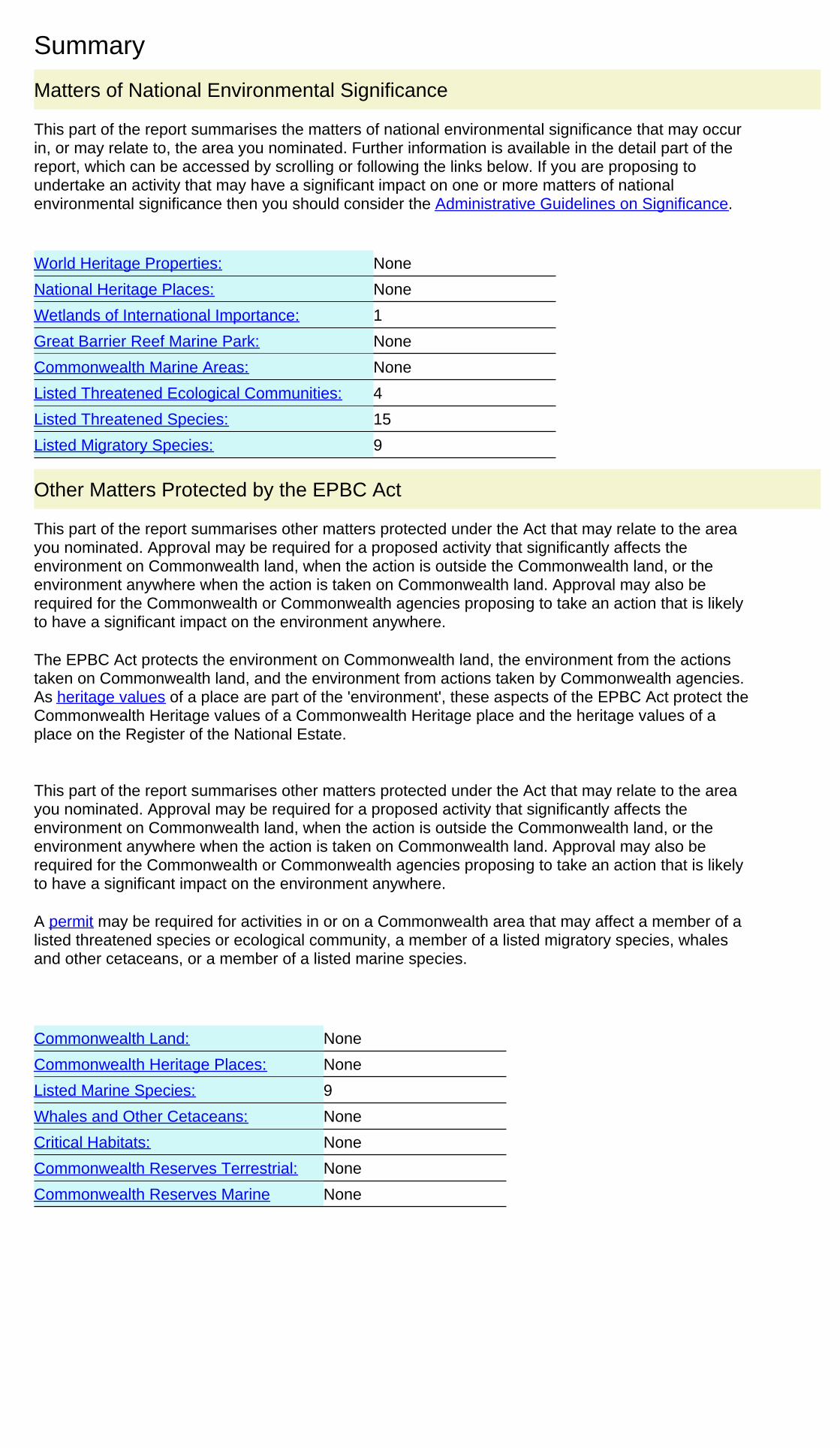
This part of the report summarises the matters of national environmental significance that may occurin, or may relate to, the area you nominated. Further information is available in the detail part of thereport, which can be accessed by scrolling or following the links below. If you are proposing toundertake an activity that may have a significant impact on one or more matters of nationalenvironmental significance then you should consider the Administrative Guidelines on Significance.
Matters of National Environmental Significance
Listed Threatened Ecological Communities:
Listed Migratory Species:
4
Great Barrier Reef Marine Park:
Wetlands of International Importance:
Listed Threatened Species:
None
15
None
None
National Heritage Places:
Commonwealth Marine Areas:
World Heritage Properties:
1
None
9
This part of the report summarises other matters protected under the Act that may relate to the areayou nominated. Approval may be required for a proposed activity that significantly affects theenvironment on Commonwealth land, when the action is outside the Commonwealth land, or theenvironment anywhere when the action is taken on Commonwealth land. Approval may also berequired for the Commonwealth or Commonwealth agencies proposing to take an action that is likelyto have a significant impact on the environment anywhere.
The EPBC Act protects the environment on Commonwealth land, the environment from the actionstaken on Commonwealth land, and the environment from actions taken by Commonwealth agencies.As heritage values of a place are part of the 'environment', these aspects of the EPBC Act protect theCommonwealth Heritage values of a Commonwealth Heritage place and the heritage values of aplace on the Register of the National Estate.
This part of the report summarises other matters protected under the Act that may relate to the areayou nominated. Approval may be required for a proposed activity that significantly affects theenvironment on Commonwealth land, when the action is outside the Commonwealth land, or theenvironment anywhere when the action is taken on Commonwealth land. Approval may also berequired for the Commonwealth or Commonwealth agencies proposing to take an action that is likelyto have a significant impact on the environment anywhere.
A permit may be required for activities in or on a Commonwealth area that may affect a member of alisted threatened species or ecological community, a member of a listed migratory species, whalesand other cetaceans, or a member of a listed marine species.
Other Matters Protected by the EPBC Act
None
None
None
Listed Marine Species:
Whales and Other Cetaceans:
9
Commonwealth Heritage Places:
None
None
Critical Habitats:
Commonwealth Land:
Commonwealth Reserves Terrestrial:
NoneCommonwealth Reserves Marine
Details
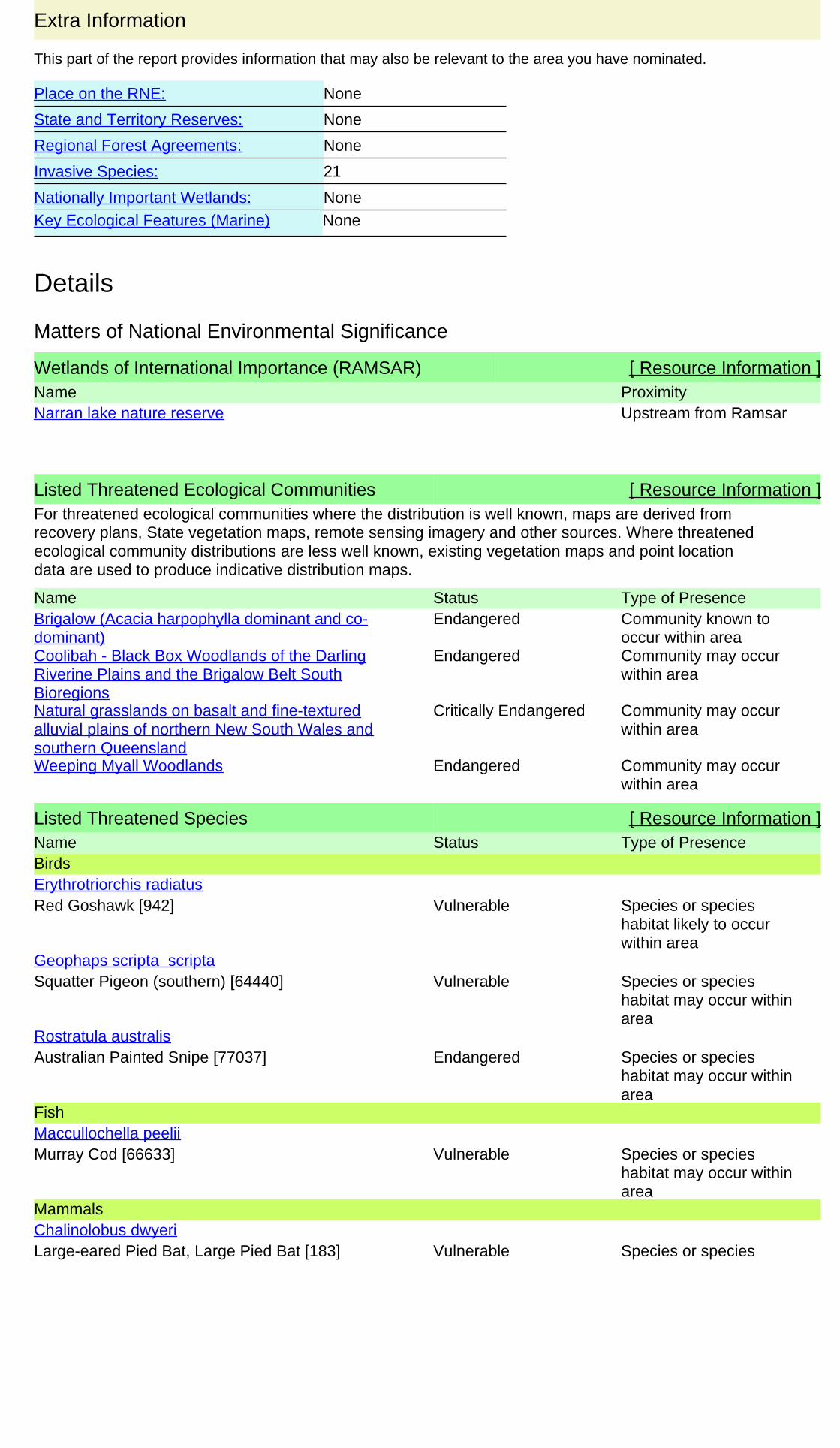
Wetlands of International Importance (RAMSAR) [ Resource Information ]Name ProximityNarran lake nature reserve Upstream from Ramsar
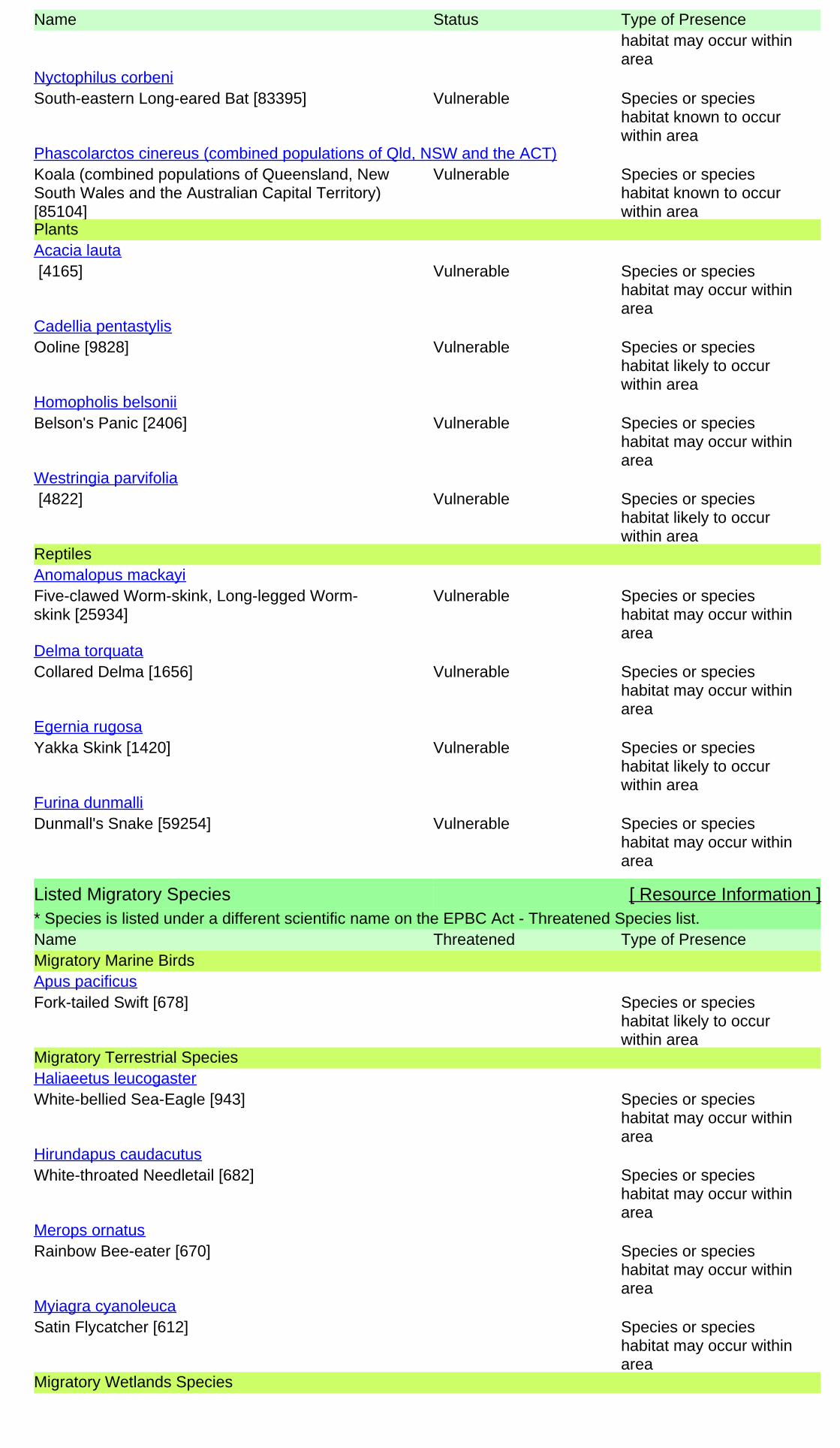
Listed Threatened Species [ Resource Information ]Name Status Type of PresenceBirds
Red Goshawk [942] Vulnerable Species or specieshabitat likely to occurwithin area
Erythrotriorchis radiatus
Squatter Pigeon (southern) [64440] Vulnerable Species or specieshabitat may occur withinarea
Geophaps scripta scripta
Australian Painted Snipe [77037] Endangered Species or specieshabitat may occur withinarea
Rostratula australis
Fish
Murray Cod [66633] Vulnerable Species or specieshabitat may occur withinarea
Maccullochella peelii
Mammals
Large-eared Pied Bat, Large Pied Bat [183] Vulnerable Species or speciesChalinolobus dwyeri
For threatened ecological communities where the distribution is well known, maps are derived fromrecovery plans, State vegetation maps, remote sensing imagery and other sources. Where threatenedecological community distributions are less well known, existing vegetation maps and point locationdata are used to produce indicative distribution maps.
Listed Threatened Ecological Communities [ Resource Information ]
Name Status Type of PresenceBrigalow (Acacia harpophylla dominant and co-dominant)
Endangered Community known tooccur within area
Coolibah - Black Box Woodlands of the DarlingRiverine Plains and the Brigalow Belt SouthBioregions
Endangered Community may occurwithin area
Natural grasslands on basalt and fine-texturedalluvial plains of northern New South Wales andsouthern Queensland
Critically Endangered Community may occurwithin area
Weeping Myall Woodlands Endangered Community may occurwithin area
Matters of National Environmental Significance
This part of the report provides information that may also be relevant to the area you have nominated.
Extra Information
Regional Forest Agreements:
21
Place on the RNE:
None
None
Invasive Species:
None
Nationally Important Wetlands:
State and Territory Reserves:
None
Key Ecological Features (Marine) None
Name Status Type of Presencehabitat may occur withinarea
South-eastern Long-eared Bat [83395] Vulnerable Species or specieshabitat known to occurwithin area
Nyctophilus corbeni
Koala (combined populations of Queensland, NewSouth Wales and the Australian Capital Territory)[85104]
Vulnerable Species or specieshabitat known to occurwithin area
Phascolarctos cinereus (combined populations of Qld, NSW and the ACT)
Plants
[4165] Vulnerable Species or specieshabitat may occur withinarea
Acacia lauta
Ooline [9828] Vulnerable Species or specieshabitat likely to occurwithin area
Cadellia pentastylis
Belson's Panic [2406] Vulnerable Species or specieshabitat may occur withinarea
Homopholis belsonii
[4822] Vulnerable Species or specieshabitat likely to occurwithin area
Westringia parvifolia
Reptiles
Five-clawed Worm-skink, Long-legged Worm-skink [25934]
Vulnerable Species or specieshabitat may occur withinarea
Anomalopus mackayi
Collared Delma [1656] Vulnerable Species or specieshabitat may occur withinarea
Delma torquata
Yakka Skink [1420] Vulnerable Species or specieshabitat likely to occurwithin area
Egernia rugosa
Dunmall's Snake [59254] Vulnerable Species or specieshabitat may occur withinarea
Furina dunmalli
Listed Migratory Species [ Resource Information ]* Species is listed under a different scientific name on the EPBC Act - Threatened Species list.Name Threatened Type of PresenceMigratory Marine Birds
Fork-tailed Swift [678] Species or specieshabitat likely to occurwithin area
Apus pacificus
Migratory Terrestrial Species
White-bellied Sea-Eagle [943] Species or specieshabitat may occur withinarea
Haliaeetus leucogaster
White-throated Needletail [682] Species or specieshabitat may occur withinarea
Hirundapus caudacutus
Rainbow Bee-eater [670] Species or specieshabitat may occur withinarea
Merops ornatus
Satin Flycatcher [612] Species or specieshabitat may occur withinarea
Myiagra cyanoleuca
Migratory Wetlands Species
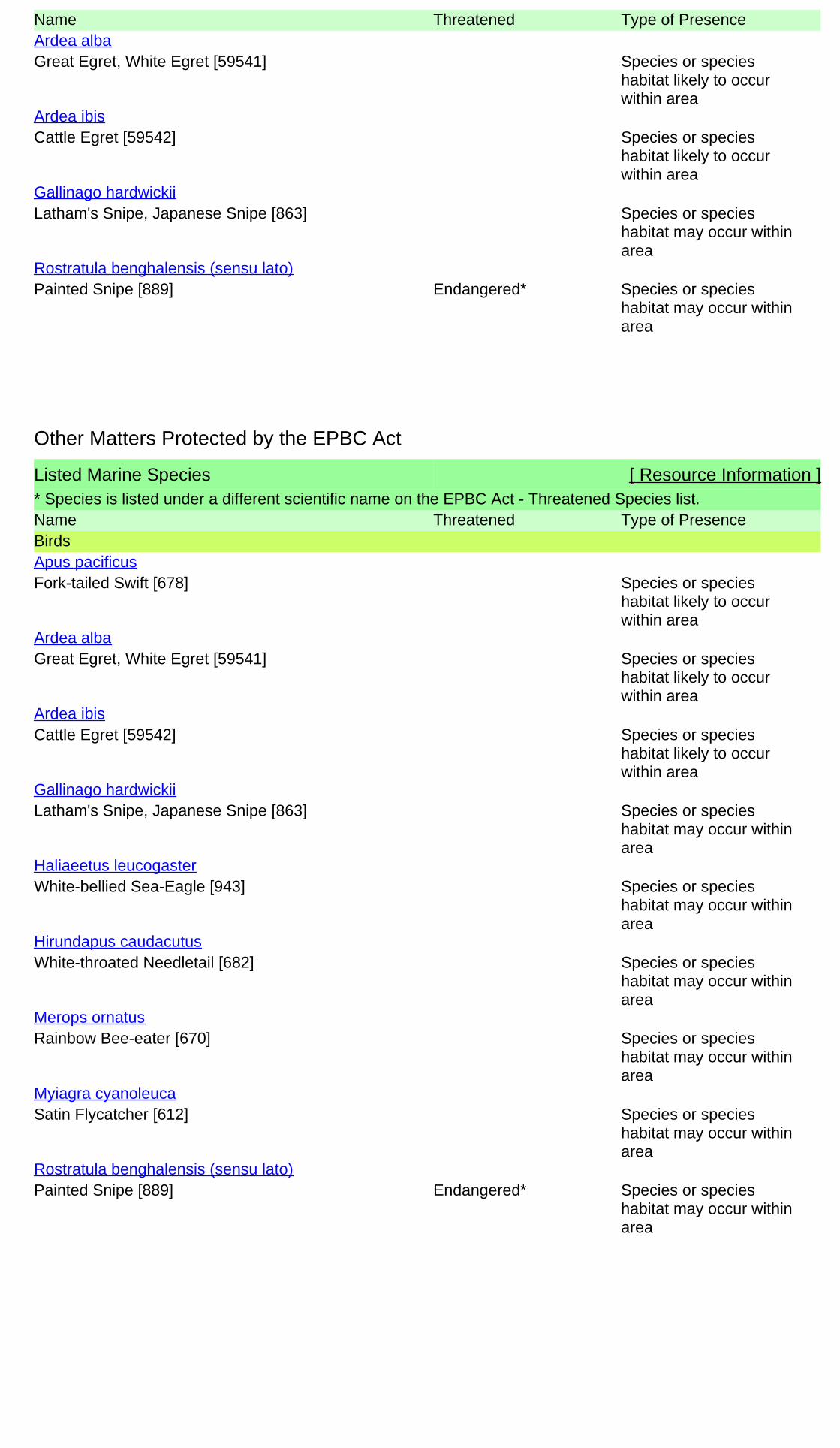
Name Threatened Type of Presence
Great Egret, White Egret [59541] Species or specieshabitat likely to occurwithin area
Ardea alba
Cattle Egret [59542] Species or specieshabitat likely to occurwithin area
Ardea ibis
Latham's Snipe, Japanese Snipe [863] Species or specieshabitat may occur withinarea
Gallinago hardwickii
Painted Snipe [889] Endangered* Species or specieshabitat may occur withinarea
Rostratula benghalensis (sensu lato)
Listed Marine Species [ Resource Information ]* Species is listed under a different scientific name on the EPBC Act - Threatened Species list.Name Threatened Type of PresenceBirds
Fork-tailed Swift [678] Species or specieshabitat likely to occurwithin area
Apus pacificus
Great Egret, White Egret [59541] Species or specieshabitat likely to occurwithin area
Ardea alba
Cattle Egret [59542] Species or specieshabitat likely to occurwithin area
Ardea ibis
Latham's Snipe, Japanese Snipe [863] Species or specieshabitat may occur withinarea
Gallinago hardwickii
White-bellied Sea-Eagle [943] Species or specieshabitat may occur withinarea
Haliaeetus leucogaster
White-throated Needletail [682] Species or specieshabitat may occur withinarea
Hirundapus caudacutus
Rainbow Bee-eater [670] Species or specieshabitat may occur withinarea
Merops ornatus
Satin Flycatcher [612] Species or specieshabitat may occur withinarea
Myiagra cyanoleuca
Painted Snipe [889] Endangered* Species or specieshabitat may occur withinarea
Rostratula benghalensis (sensu lato)
Other Matters Protected by the EPBC Act
Extra Information
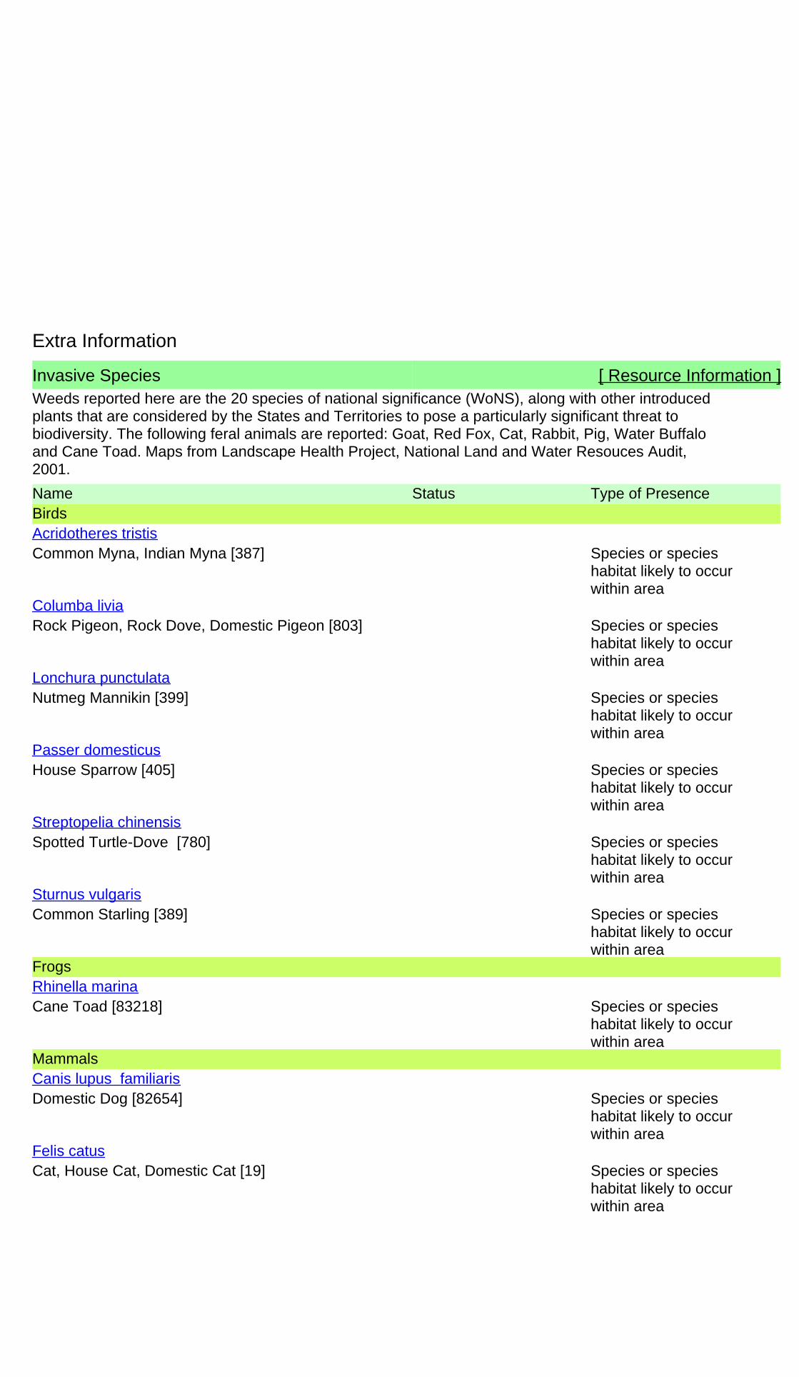
Invasive Species [ Resource Information ]Weeds reported here are the 20 species of national significance (WoNS), along with other introducedplants that are considered by the States and Territories to pose a particularly significant threat tobiodiversity. The following feral animals are reported: Goat, Red Fox, Cat, Rabbit, Pig, Water Buffaloand Cane Toad. Maps from Landscape Health Project, National Land and Water Resouces Audit,2001.
Name Status Type of PresenceBirds
Common Myna, Indian Myna [387] Species or specieshabitat likely to occurwithin area
Acridotheres tristis
Rock Pigeon, Rock Dove, Domestic Pigeon [803] Species or specieshabitat likely to occurwithin area
Columba livia
Nutmeg Mannikin [399] Species or specieshabitat likely to occurwithin area
Lonchura punctulata
House Sparrow [405] Species or specieshabitat likely to occurwithin area
Passer domesticus
Spotted Turtle-Dove [780] Species or specieshabitat likely to occurwithin area
Streptopelia chinensis
Common Starling [389] Species or specieshabitat likely to occurwithin area
Sturnus vulgaris
Frogs
Cane Toad [83218] Species or specieshabitat likely to occurwithin area
Rhinella marina
Mammals
Domestic Dog [82654] Species or specieshabitat likely to occurwithin area
Canis lupus familiaris
Cat, House Cat, Domestic Cat [19] Species or specieshabitat likely to occurwithin area
Felis catus
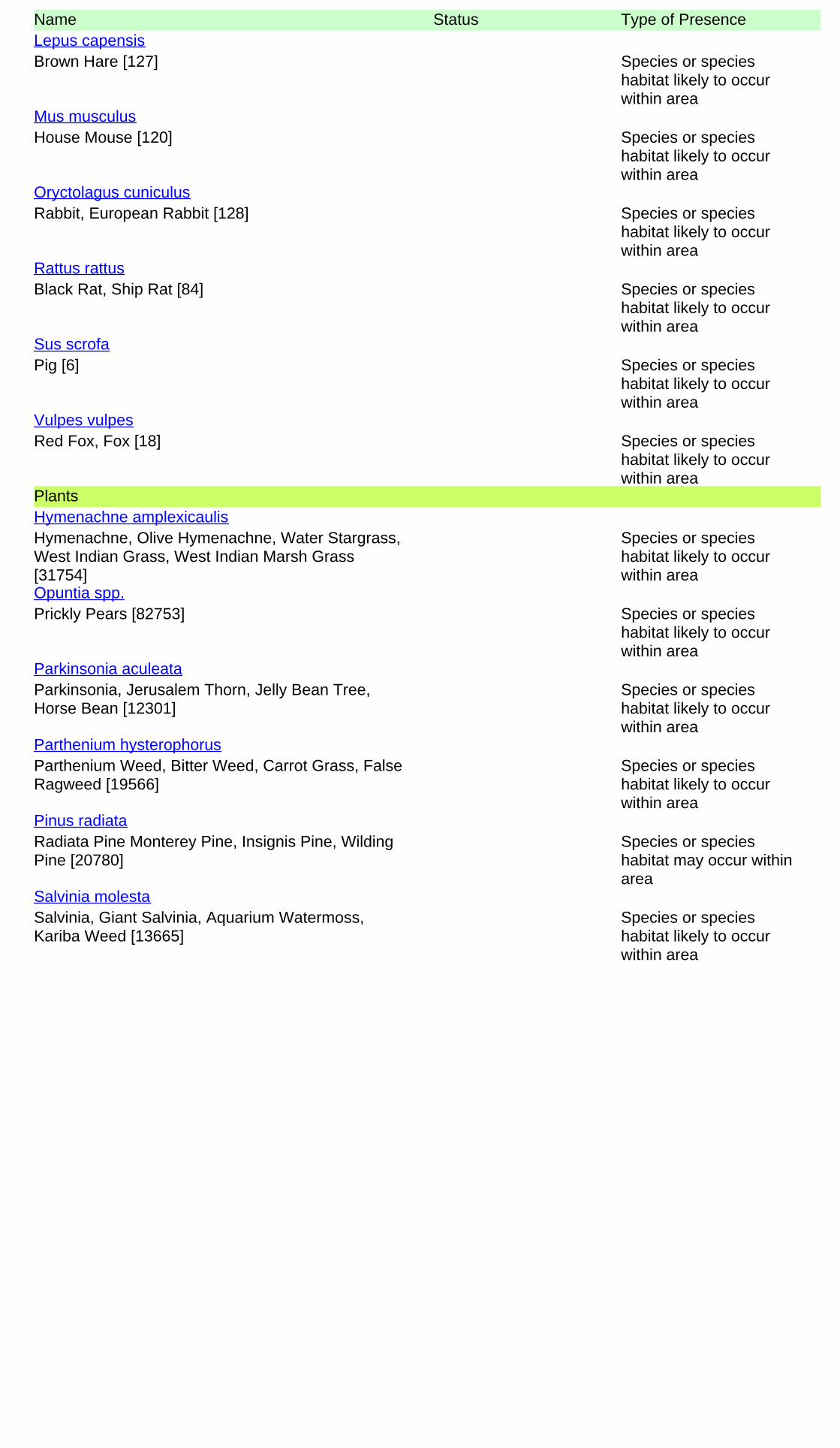
Name Status Type of Presence
Brown Hare [127] Species or specieshabitat likely to occurwithin area
Lepus capensis
House Mouse [120] Species or specieshabitat likely to occurwithin area
Mus musculus
Rabbit, European Rabbit [128] Species or specieshabitat likely to occurwithin area
Oryctolagus cuniculus
Black Rat, Ship Rat [84] Species or specieshabitat likely to occurwithin area
Rattus rattus
Pig [6] Species or specieshabitat likely to occurwithin area
Sus scrofa
Red Fox, Fox [18] Species or specieshabitat likely to occurwithin area
Vulpes vulpes
Plants
Hymenachne, Olive Hymenachne, Water Stargrass,West Indian Grass, West Indian Marsh Grass[31754]
Species or specieshabitat likely to occurwithin area
Hymenachne amplexicaulis
Prickly Pears [82753] Species or specieshabitat likely to occurwithin area
Opuntia spp.
Parkinsonia, Jerusalem Thorn, Jelly Bean Tree,Horse Bean [12301]
Species or specieshabitat likely to occurwithin area
Parkinsonia aculeata
Parthenium Weed, Bitter Weed, Carrot Grass, FalseRagweed [19566]
Species or specieshabitat likely to occurwithin area
Parthenium hysterophorus
Radiata Pine Monterey Pine, Insignis Pine, WildingPine [20780]
Species or specieshabitat may occur withinarea
Pinus radiata
Salvinia, Giant Salvinia, Aquarium Watermoss,Kariba Weed [13665]
Species or specieshabitat likely to occurwithin area
Salvinia molesta
-27.04894 150.28725
Coordinates
- non-threatened seabirds which have only been mapped for recorded breeding sites
- migratory species that are very widespread, vagrant, or only occur in small numbers
- some species and ecological communities that have only recently been listed
Not all species listed under the EPBC Act have been mapped (see below) and therefore a report is a generalguide only. Where available data supports mapping, the type of presence that can be determined from thedata is indicated in general terms. People using this information in making a referral may need to considerthe qualifications below and may need to seek and consider other information sources.
For threatened ecological communities where the distribution is well known, maps are derived fromrecovery plans, State vegetation maps, remote sensing imagery and other sources. Where threatenedecological community distributions are less well known, existing vegetation maps and point location dataare used to produce indicative distribution maps.
- seals which have only been mapped for breeding sites near the Australian continentSuch breeding sites may be important for the protection of the Commonwealth Marine environment.
For species where the distributions are well known, maps are digitised from sources such as recovery plansand detailed habitat studies. Where appropriate, core breeding, foraging and roosting areas are indicatedunder 'type of presence'. For species whose distributions are less well known, point locations are collatedfrom government wildlife authorities, museums, and non-government organisations; bioclimaticdistribution models are generated and these validated by experts. In some cases, the distribution maps arebased solely on expert knowledge.
The information presented in this report has been provided by a range of data sources as acknowledged atthe end of the report.
Caveat
- migratory and
The following species and ecological communities have not been mapped and do not appear in reportsproduced from this database:
- marine
This report is designed to assist in identifying the locations of places which may be relevant in determiningobligations under the Environment Protection and Biodiversity Conservation Act 1999. It holds mappedlocations of World Heritage and Register of National Estate properties, Wetlands of InternationalImportance, Commonwealth and State/Territory reserves, listed threatened, migratory and marine speciesand listed threatened ecological communities. Mapping of Commonwealth land is not complete at thisstage. Maps have been collated from a range of sources at various resolutions.
- threatened species listed as extinct or considered as vagrants
- some terrestrial species that overfly the Commonwealth marine area
The following groups have been mapped, but may not cover the complete distribution of the species:
Only selected species covered by the following provisions of the EPBC Act have been mapped:
-Department of the Environment, Climate Change, Energy and Water-Birds Australia-Australian Bird and Bat Banding Scheme
-Department of Environment and Conservation, Western Australia
Acknowledgements
-Department of Environment, Climate Change and Water, New South Wales
-Department of Primary Industries, Parks, Water and Environment, Tasmania
-Parks and Wildlife Service NT, NT Dept of Natural Resources, Environment and the Arts-Environmental and Resource Management, Queensland
-Department of Sustainability and Environment, Victoria
-Australian National Wildlife Collection
-Department of Environment and Natural Resources, South Australia
This database has been compiled from a range of data sources. The department acknowledges thefollowing custodians who have contributed valuable data and advice:
-Australian Museum
-National Herbarium of NSW
-State Forests of NSW-Australian Government, Department of Defence
-State Herbarium of South Australia
The Department is extremely grateful to the many organisations and individuals who providedexpert advice and information on numerous draft distributions.
-Natural history museums of Australia
-Queensland Museum
-Australian National Herbarium, Atherton and Canberra
-Royal Botanic Gardens and National Herbarium of Victoria
-Geoscience Australia
-Ocean Biogeographic Information System
-Online Zoological Collections of Australian Museums-Queensland Herbarium
-Western Australian Herbarium
-Tasmanian Herbarium
-Northern Territory Herbarium
-SA Museum
-Museum Victoria
-University of New England
-CSIRO-Other groups and individuals
© Commonwealth of Australia
+61 2 6274 1111
Canberra ACT 2601 Australia
GPO Box 787
Department of the Environment
Please feel free to provide feedback via the Contact Us page.

Ecology Assessment Report REPORT
Doc Ref: Q-4530-15-RP-1051 Revision: 0 Page 23 of 34
Business Integrity, Australia Pacific LNG Project
Uncontrolled when printed unless issued and stamped Controlled Copy.
Appendix C: Wildlife Online Database Search Results
The search of the Wildlife Online database was carried out on 02/11/2014.
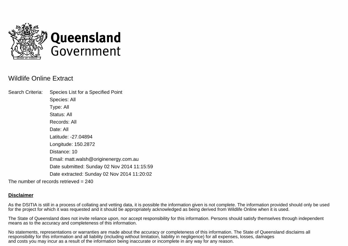
Wildlife Online Extract
Search Criteria: Species List for a Specified Point
Species: All
Type: All
Status: All
Records: All
Date: All
Latitude: -27.04894
Longitude: 150.2872
Distance: 10
Email: [email protected]
Date submitted: Sunday 02 Nov 2014 11:15:59
Date extracted: Sunday 02 Nov 2014 11:20:02
The number of records retrieved = 240
Disclaimer
As the DSITIA is still in a process of collating and vetting data, it is possible the information given is not complete. The information provided should only be usedfor the project for which it was requested and it should be appropriately acknowledged as being derived from Wildlife Online when it is used.
The State of Queensland does not invite reliance upon, nor accept responsibility for this information. Persons should satisfy themselves through independentmeans as to the accuracy and completeness of this information.
No statements, representations or warranties are made about the accuracy or completeness of this information. The State of Queensland disclaims allresponsibility for this information and all liability (including without limitation, liability in negligence) for all expenses, losses, damagesand costs you may incur as a result of the information being inaccurate or incomplete in any way for any reason.
Feedback about Wildlife Online should be emailed to [email protected]
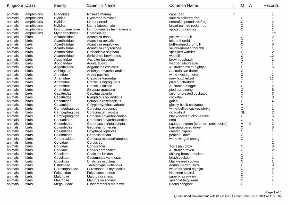
Kingdom Class Family Scientific Name Common Name I Q A Records
animals amphibians Bufonidae Rhinella marina cane toad Y 1 animals amphibians Hylidae Cyclorana brevipes superb collared frog C 1 animals amphibians Hylidae Litoria peronii emerald spotted treefrog C 2 animals amphibians Hylidae Litoria latopalmata broad palmed rocketfrog C 1 animals amphibians Limnodynastidae Limnodynastes tasmaniensis spotted grassfrog C 1 animals amphibians Myobatrachidae Uperoleia sp. 1/1animals birds Acanthizidae Acanthiza nana yellow thornbill C 2 animals birds Acanthizidae Acanthiza apicalis inland thornbill C 4 animals birds Acanthizidae Acanthiza reguloides buff-rumped thornbill C 5 animals birds Acanthizidae Acanthiza chrysorrhoa yellow-rumped thornbill C 1 animals birds Acanthizidae Chthonicola sagittata speckled warbler C 2 animals birds Acanthizidae Smicrornis brevirostris weebill C 12 animals birds Accipitridae Accipiter fasciatus brown goshawk C 1 animals birds Accipitridae Aquila audax wedge-tailed eagle C 1 animals birds Aegothelidae Aegotheles cristatus Australian owlet-nightjar C 5 animals birds Anhingidae Anhinga novaehollandiae Australasian darter C 1 animals birds Ardeidae Ardea pacifica white-necked heron C 1 animals birds Artamidae Cracticus torquatus grey butcherbird C 11 animals birds Artamidae Cracticus nigrogularis pied butcherbird C 1 animals birds Artamidae Cracticus tibicen Australian magpie C 2 animals birds Artamidae Strepera graculina pied currawong C 8 animals birds Cacatuidae Cacatua galerita sulphur-crested cockatoo C 3 animals birds Cacatuidae Nymphicus hollandicus cockatiel C 3 animals birds Cacatuidae Eolophus roseicapillus galah C 4 animals birds Cacatuidae Calyptorhynchus lathami glossy black-cockatoo V 1 animals birds Campephagidae Coracina papuensis white-bellied cuckoo-shrike C 1 animals birds Campephagidae Coracina tenuirostris cicadabird SL 2 animals birds Campephagidae Coracina novaehollandiae black-faced cuckoo-shrike C 5 animals birds Casuariidae Dromaius novaehollandiae emu C 4 animals birds Columbidae Geophaps scripta scripta squatter pigeon (southern subspecies) V V 1 animals birds Columbidae Geopelia humeralis bar-shouldered dove C 5 animals birds Columbidae Ocyphaps lophotes crested pigeon C 1 animals birds Columbidae Geopelia striata peaceful dove C 1 animals birds Corcoracidae Corcorax melanorhamphos white-winged chough C 1 animals birds Corvidae Corvus sp. 2 animals birds Corvidae Corvus orru Torresian crow C 3 animals birds Corvidae Corvus coronoides Australian raven C 2 animals birds Cuculidae Chalcites lucidus shining bronze-cuckoo C 1 animals birds Cuculidae Cacomantis variolosus brush cuckoo C 1 animals birds Cuculidae Chalcites osculans black-eared cuckoo C 1 animals birds Estrildidae Taeniopygia bichenovii double-barred finch C 3 animals birds Eurostopodidae Eurostopodus mystacalis white-throated nightjar C 2 animals birds Falconidae Falco cenchroides Nankeen kestrel C 1 animals birds Maluridae Malurus cyaneus superb fairy-wren C 4 animals birds Maluridae Malurus splendens splendid fairy-wren C 1 animals birds Megaluridae Cincloramphus mathewsi rufous songlark C 1
Page 1 of 6Queensland Government Wildlife Online - Extract Date 02/11/2014 at 11:20:02
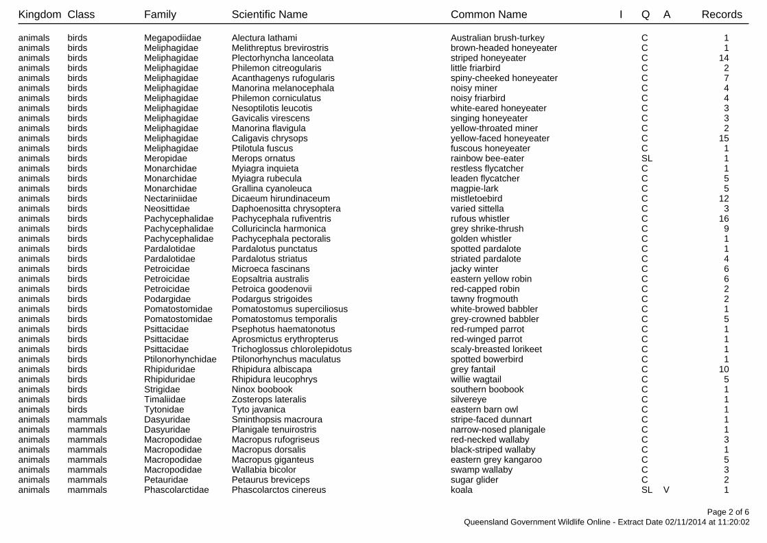
Kingdom Class Family Scientific Name Common Name I Q A Records
animals birds Megapodiidae Alectura lathami Australian brush-turkey C 1 animals birds Meliphagidae Melithreptus brevirostris brown-headed honeyeater C 1 animals birds Meliphagidae Plectorhyncha lanceolata striped honeyeater C 14 animals birds Meliphagidae Philemon citreogularis little friarbird C 2 animals birds Meliphagidae Acanthagenys rufogularis spiny-cheeked honeyeater C 7 animals birds Meliphagidae Manorina melanocephala noisy miner C 4 animals birds Meliphagidae Philemon corniculatus noisy friarbird C 4 animals birds Meliphagidae Nesoptilotis leucotis white-eared honeyeater C 3 animals birds Meliphagidae Gavicalis virescens singing honeyeater C 3 animals birds Meliphagidae Manorina flavigula yellow-throated miner C 2 animals birds Meliphagidae Caligavis chrysops yellow-faced honeyeater C 15 animals birds Meliphagidae Ptilotula fuscus fuscous honeyeater C 1 animals birds Meropidae Merops ornatus rainbow bee-eater SL 1 animals birds Monarchidae Myiagra inquieta restless flycatcher C 1 animals birds Monarchidae Myiagra rubecula leaden flycatcher C 5 animals birds Monarchidae Grallina cyanoleuca magpie-lark C 5 animals birds Nectariniidae Dicaeum hirundinaceum mistletoebird C 12 animals birds Neosittidae Daphoenositta chrysoptera varied sittella C 3 animals birds Pachycephalidae Pachycephala rufiventris rufous whistler C 16 animals birds Pachycephalidae Colluricincla harmonica grey shrike-thrush C 9 animals birds Pachycephalidae Pachycephala pectoralis golden whistler C 1 animals birds Pardalotidae Pardalotus punctatus spotted pardalote C 1 animals birds Pardalotidae Pardalotus striatus striated pardalote C 4 animals birds Petroicidae Microeca fascinans jacky winter C 6 animals birds Petroicidae Eopsaltria australis eastern yellow robin C 6 animals birds Petroicidae Petroica goodenovii red-capped robin C 2 animals birds Podargidae Podargus strigoides tawny frogmouth C 2 animals birds Pomatostomidae Pomatostomus superciliosus white-browed babbler C 1 animals birds Pomatostomidae Pomatostomus temporalis grey-crowned babbler C 5 animals birds Psittacidae Psephotus haematonotus red-rumped parrot C 1 animals birds Psittacidae Aprosmictus erythropterus red-winged parrot C 1 animals birds Psittacidae Trichoglossus chlorolepidotus scaly-breasted lorikeet C 1 animals birds Ptilonorhynchidae Ptilonorhynchus maculatus spotted bowerbird C 1 animals birds Rhipiduridae Rhipidura albiscapa grey fantail C 10 animals birds Rhipiduridae Rhipidura leucophrys willie wagtail C 5 animals birds Strigidae Ninox boobook southern boobook C 1 animals birds Timaliidae Zosterops lateralis silvereye C 1 animals birds Tytonidae Tyto javanica eastern barn owl C 1 animals mammals Dasyuridae Sminthopsis macroura stripe-faced dunnart C 1 animals mammals Dasyuridae Planigale tenuirostris narrow-nosed planigale C 1 animals mammals Macropodidae Macropus rufogriseus red-necked wallaby C 3 animals mammals Macropodidae Macropus dorsalis black-striped wallaby C 1 animals mammals Macropodidae Macropus giganteus eastern grey kangaroo C 5 animals mammals Macropodidae Wallabia bicolor swamp wallaby C 3 animals mammals Petauridae Petaurus breviceps sugar glider C 2 animals mammals Phascolarctidae Phascolarctos cinereus koala SL V 1
Page 2 of 6Queensland Government Wildlife Online - Extract Date 02/11/2014 at 11:20:02
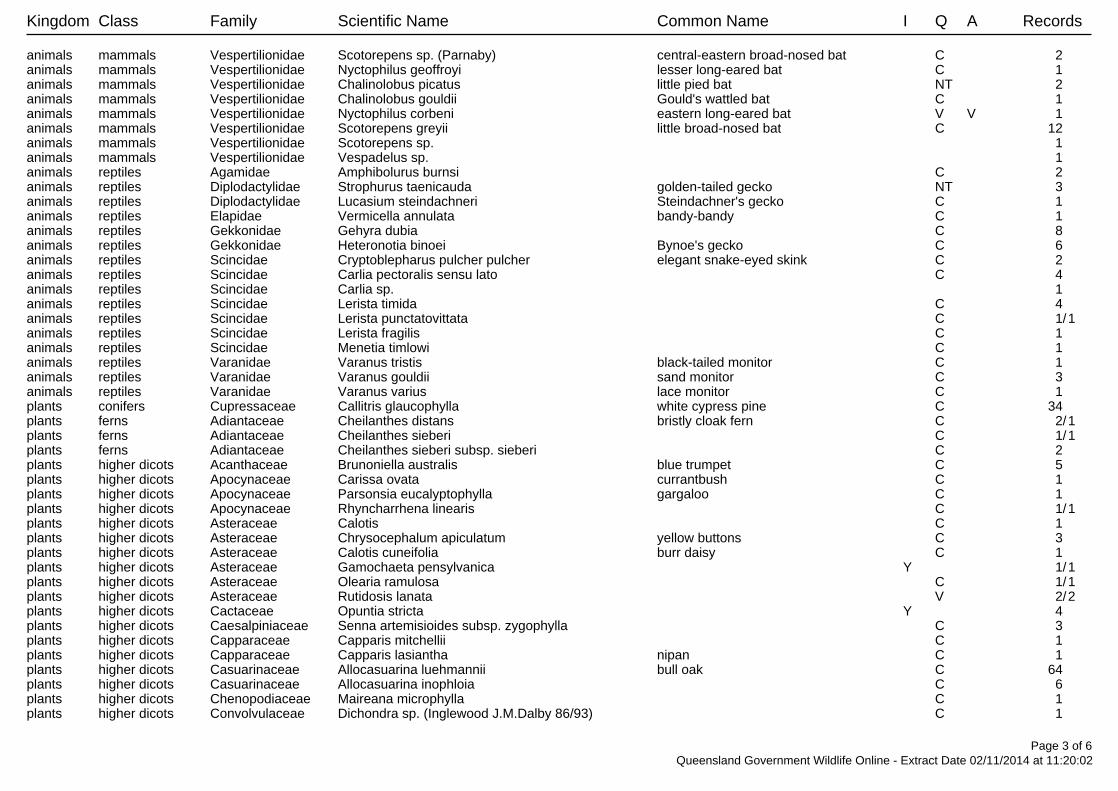
Kingdom Class Family Scientific Name Common Name I Q A Records
animals mammals Vespertilionidae Scotorepens sp. (Parnaby) central-eastern broad-nosed bat C 2 animals mammals Vespertilionidae Nyctophilus geoffroyi lesser long-eared bat C 1 animals mammals Vespertilionidae Chalinolobus picatus little pied bat NT 2 animals mammals Vespertilionidae Chalinolobus gouldii Gould's wattled bat C 1 animals mammals Vespertilionidae Nyctophilus corbeni eastern long-eared bat V V 1 animals mammals Vespertilionidae Scotorepens greyii little broad-nosed bat C 12 animals mammals Vespertilionidae Scotorepens sp. 1 animals mammals Vespertilionidae Vespadelus sp. 1 animals reptiles Agamidae Amphibolurus burnsi C 2 animals reptiles Diplodactylidae Strophurus taenicauda golden-tailed gecko NT 3 animals reptiles Diplodactylidae Lucasium steindachneri Steindachner's gecko C 1 animals reptiles Elapidae Vermicella annulata bandy-bandy C 1 animals reptiles Gekkonidae Gehyra dubia C 8 animals reptiles Gekkonidae Heteronotia binoei Bynoe's gecko C 6 animals reptiles Scincidae Cryptoblepharus pulcher pulcher elegant snake-eyed skink C 2 animals reptiles Scincidae Carlia pectoralis sensu lato C 4 animals reptiles Scincidae Carlia sp. 1 animals reptiles Scincidae Lerista timida C 4 animals reptiles Scincidae Lerista punctatovittata C 1/1animals reptiles Scincidae Lerista fragilis C 1 animals reptiles Scincidae Menetia timlowi C 1 animals reptiles Varanidae Varanus tristis black-tailed monitor C 1 animals reptiles Varanidae Varanus gouldii sand monitor C 3 animals reptiles Varanidae Varanus varius lace monitor C 1 plants conifers Cupressaceae Callitris glaucophylla white cypress pine C 34 plants ferns Adiantaceae Cheilanthes distans bristly cloak fern C 2/1plants ferns Adiantaceae Cheilanthes sieberi C 1/1plants ferns Adiantaceae Cheilanthes sieberi subsp. sieberi C 2 plants higher dicots Acanthaceae Brunoniella australis blue trumpet C 5 plants higher dicots Apocynaceae Carissa ovata currantbush C 1 plants higher dicots Apocynaceae Parsonsia eucalyptophylla gargaloo C 1 plants higher dicots Apocynaceae Rhyncharrhena linearis C 1/1plants higher dicots Asteraceae Calotis C 1 plants higher dicots Asteraceae Chrysocephalum apiculatum yellow buttons C 3 plants higher dicots Asteraceae Calotis cuneifolia burr daisy C 1 plants higher dicots Asteraceae Gamochaeta pensylvanica Y 1/1plants higher dicots Asteraceae Olearia ramulosa C 1/1plants higher dicots Asteraceae Rutidosis lanata V 2/2plants higher dicots Cactaceae Opuntia stricta Y 4 plants higher dicots Caesalpiniaceae Senna artemisioides subsp. zygophylla C 3 plants higher dicots Capparaceae Capparis mitchellii C 1 plants higher dicots Capparaceae Capparis lasiantha nipan C 1 plants higher dicots Casuarinaceae Allocasuarina luehmannii bull oak C 64 plants higher dicots Casuarinaceae Allocasuarina inophloia C 6 plants higher dicots Chenopodiaceae Maireana microphylla C 1 plants higher dicots Convolvulaceae Dichondra sp. (Inglewood J.M.Dalby 86/93) C 1
Page 3 of 6Queensland Government Wildlife Online - Extract Date 02/11/2014 at 11:20:02

Kingdom Class Family Scientific Name Common Name I Q A Records
plants higher dicots Droseraceae Drosera burmanni C 1/1plants higher dicots Droseraceae Drosera finlaysoniana C 1/1plants higher dicots Fabaceae Daviesia genistifolia broom bitter pea C 1/1plants higher dicots Fabaceae Glycine clandestina var. sericea C 1 plants higher dicots Goodeniaceae Goodenia glabra C 3 plants higher dicots Haloragaceae Myriophyllum simulans C 1/1plants higher dicots Haloragaceae Gonocarpus chinensis subsp. verrucosus C 1 plants higher dicots Lamiaceae Westringia cheelii C 2/2plants higher dicots Lamiaceae Prostanthera C 1 plants higher dicots Loranthaceae Amyema pendula subsp. longifolia C 1/1plants higher dicots Loranthaceae Amyema quandang var. bancroftii broad-leaved grey mistletoe C 2 plants higher dicots Loranthaceae Amyema quandang var. quandang C 1 plants higher dicots Loranthaceae Lysiana exocarpi subsp. tenuis C 2 plants higher dicots Malvaceae Hibiscus sturtii var. sturtii C 5 plants higher dicots Meliaceae Owenia acidula emu apple C 2 plants higher dicots Mimosaceae Acacia juncifolia C 1 plants higher dicots Mimosaceae Acacia muelleriana C 1/1plants higher dicots Mimosaceae Acacia spectabilis pilliga wattle C 1 plants higher dicots Mimosaceae Acacia blakei subsp. blakei C 8 plants higher dicots Mimosaceae Acacia crassa subsp. crassa C 28/1plants higher dicots Mimosaceae Acacia leiocalyx subsp. leiocalyx C 11 plants higher dicots Mimosaceae Acacia wardellii V 10/3plants higher dicots Mimosaceae Acacia hakeoides hakea wattle C 2/1plants higher dicots Mimosaceae Acacia conferta C 2 plants higher dicots Mimosaceae Acacia burrowii C 42 plants higher dicots Mimosaceae Acacia jucunda C 2/1plants higher dicots Mimosaceae Acacia C 1 plants higher dicots Mimosaceae Acacia neriifolia pechey wattle C 1/1plants higher dicots Mimosaceae Acacia harpophylla brigalow C 14 plants higher dicots Myrtaceae Kardomia jucunda C 1/1plants higher dicots Myrtaceae Melaleuca decora C 1 plants higher dicots Myrtaceae Eucalyptus bakeri Baker's mallee C 2/2plants higher dicots Myrtaceae Eucalyptus crebra narrow-leaved red ironbark C 130 plants higher dicots Myrtaceae Eucalyptus elegans C 3 plants higher dicots Myrtaceae Eucalyptus exserta Queensland peppermint C 11 plants higher dicots Myrtaceae Eucalyptus viridis C 2/2plants higher dicots Myrtaceae Angophora leiocarpa rusty gum C 2/1plants higher dicots Myrtaceae Eucalyptus populnea poplar box C 4 plants higher dicots Myrtaceae Melaleuca lanceolata C 1/1plants higher dicots Myrtaceae Corymbia clarksoniana C 2 plants higher dicots Myrtaceae Eucalyptus woollsiana C 60/1plants higher dicots Myrtaceae Eucalyptus chloroclada Baradine red gum C 1 plants higher dicots Myrtaceae Eucalyptus decorticans C 1/1plants higher dicots Myrtaceae Melaleuca densispicata C 1/1plants higher dicots Myrtaceae Eucalyptus fibrosa subsp. nubila C 35 plants higher dicots Myrtaceae Corymbia trachyphloia subsp. trachyphloia C 7
Page 4 of 6Queensland Government Wildlife Online - Extract Date 02/11/2014 at 11:20:02
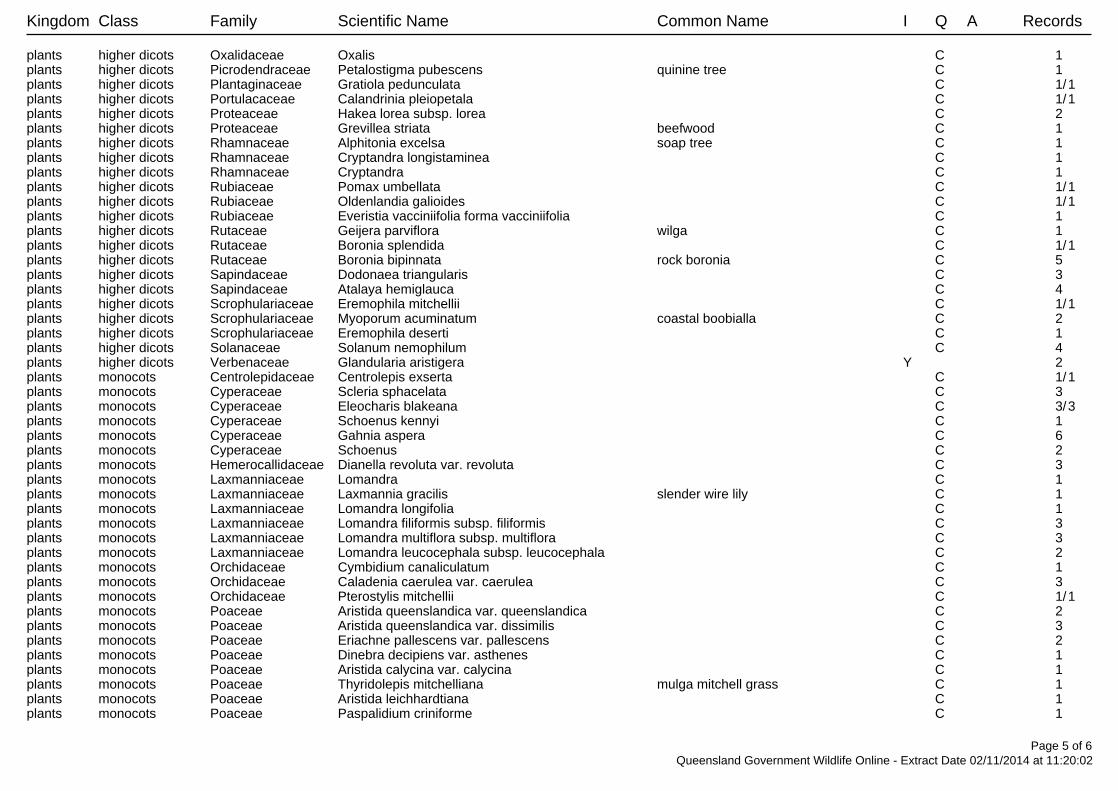
Kingdom Class Family Scientific Name Common Name I Q A Records
plants higher dicots Oxalidaceae Oxalis C 1 plants higher dicots Picrodendraceae Petalostigma pubescens quinine tree C 1 plants higher dicots Plantaginaceae Gratiola pedunculata C 1/1plants higher dicots Portulacaceae Calandrinia pleiopetala C 1/1plants higher dicots Proteaceae Hakea lorea subsp. lorea C 2 plants higher dicots Proteaceae Grevillea striata beefwood C 1 plants higher dicots Rhamnaceae Alphitonia excelsa soap tree C 1 plants higher dicots Rhamnaceae Cryptandra longistaminea C 1 plants higher dicots Rhamnaceae Cryptandra C 1 plants higher dicots Rubiaceae Pomax umbellata C 1/1plants higher dicots Rubiaceae Oldenlandia galioides C 1/1plants higher dicots Rubiaceae Everistia vacciniifolia forma vacciniifolia C 1 plants higher dicots Rutaceae Geijera parviflora wilga C 1 plants higher dicots Rutaceae Boronia splendida C 1/1plants higher dicots Rutaceae Boronia bipinnata rock boronia C 5 plants higher dicots Sapindaceae Dodonaea triangularis C 3 plants higher dicots Sapindaceae Atalaya hemiglauca C 4 plants higher dicots Scrophulariaceae Eremophila mitchellii C 1/1plants higher dicots Scrophulariaceae Myoporum acuminatum coastal boobialla C 2 plants higher dicots Scrophulariaceae Eremophila deserti C 1 plants higher dicots Solanaceae Solanum nemophilum C 4 plants higher dicots Verbenaceae Glandularia aristigera Y 2 plants monocots Centrolepidaceae Centrolepis exserta C 1/1plants monocots Cyperaceae Scleria sphacelata C 3 plants monocots Cyperaceae Eleocharis blakeana C 3/3plants monocots Cyperaceae Schoenus kennyi C 1 plants monocots Cyperaceae Gahnia aspera C 6 plants monocots Cyperaceae Schoenus C 2 plants monocots Hemerocallidaceae Dianella revoluta var. revoluta C 3 plants monocots Laxmanniaceae Lomandra C 1 plants monocots Laxmanniaceae Laxmannia gracilis slender wire lily C 1 plants monocots Laxmanniaceae Lomandra longifolia C 1 plants monocots Laxmanniaceae Lomandra filiformis subsp. filiformis C 3 plants monocots Laxmanniaceae Lomandra multiflora subsp. multiflora C 3 plants monocots Laxmanniaceae Lomandra leucocephala subsp. leucocephala C 2 plants monocots Orchidaceae Cymbidium canaliculatum C 1 plants monocots Orchidaceae Caladenia caerulea var. caerulea C 3 plants monocots Orchidaceae Pterostylis mitchellii C 1/1plants monocots Poaceae Aristida queenslandica var. queenslandica C 2 plants monocots Poaceae Aristida queenslandica var. dissimilis C 3 plants monocots Poaceae Eriachne pallescens var. pallescens C 2 plants monocots Poaceae Dinebra decipiens var. asthenes C 1 plants monocots Poaceae Aristida calycina var. calycina C 1 plants monocots Poaceae Thyridolepis mitchelliana mulga mitchell grass C 1 plants monocots Poaceae Aristida leichhardtiana C 1 plants monocots Poaceae Paspalidium criniforme C 1
Page 5 of 6Queensland Government Wildlife Online - Extract Date 02/11/2014 at 11:20:02
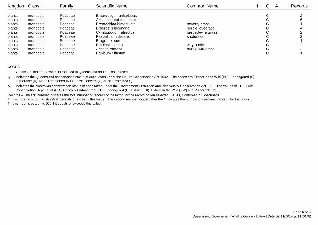
Kingdom Class Family Scientific Name Common Name I Q A Records
plants monocots Poaceae Enteropogon unispiceus C 2 plants monocots Poaceae Aristida caput-medusae C 6 plants monocots Poaceae Eremochloa bimaculata poverty grass C 1 plants monocots Poaceae Eragrostis lacunaria purple lovegrass C 4 plants monocots Poaceae Cymbopogon refractus barbed-wire grass C 2 plants monocots Poaceae Paspalidium distans shotgrass C 2 plants monocots Poaceae Eragrostis sororia C 1 plants monocots Poaceae Entolasia stricta wiry panic C 2 plants monocots Poaceae Aristida ramosa purple wiregrass C 2 plants monocots Poaceae Panicum effusum C 1
CODES
I - Y indicates that the taxon is introduced to Queensland and has naturalised.
Q - Indicates the Queensland conservation status of each taxon under the Nature Conservation Act 1992. The codes are Extinct in the Wild (PE), Endangered (E),Vulnerable (V), Near Threatened (NT), Least Concern (C) or Not Protected ( ).
A - Indicates the Australian conservation status of each taxon under the Environment Protection and Biodiversity Conservation Act 1999. The values of EPBC areConservation Dependent (CD), Critically Endangered (CE), Endangered (E), Extinct (EX), Extinct in the Wild (XW) and Vulnerable (V).
Records – The first number indicates the total number of records of the taxon for the record option selected (i.e. All, Confirmed or Specimens).This number is output as 99999 if it equals or exceeds this value. The second number located after the / indicates the number of specimen records for the taxon.This number is output as 999 if it equals or exceeds this value.
Page 6 of 6Queensland Government Wildlife Online - Extract Date 02/11/2014 at 11:20:02
Ecology Assessment Report REPORT
Doc Ref: Q-4530-15-RP-1051 Revision: 0 Page 24 of 34
Business Integrity, Australia Pacific LNG Project
Uncontrolled when printed unless issued and stamped Controlled Copy.
Appendix D: EHP Mapped Regional Ecosystems
This Appendix provides an overview of EHP mapped regional ecosystems.
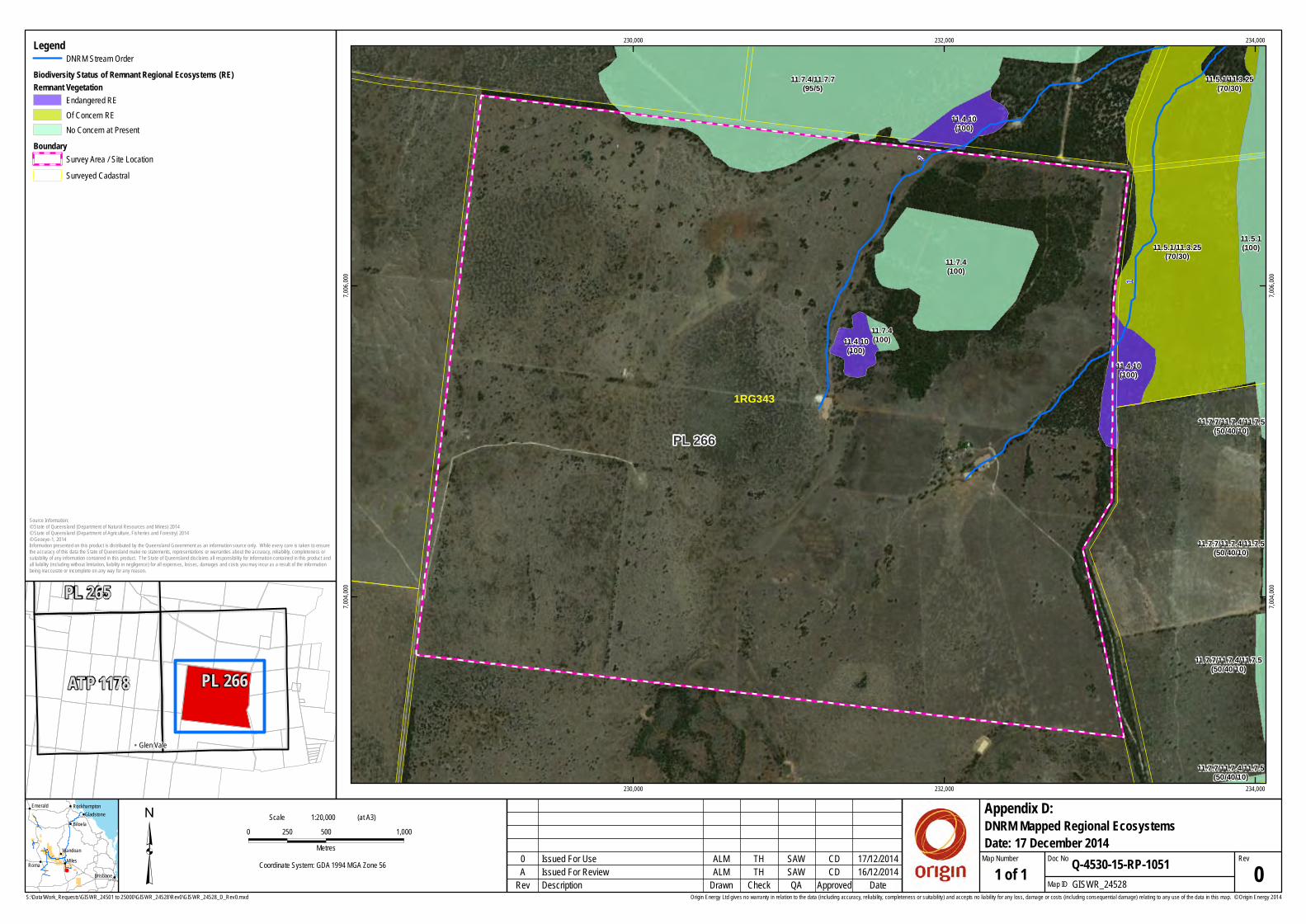
S:\Data\Work_Requests\GISWR_24501 to 25000\GISWR_24528\Rev0\GISWR_24528_D_Rev0.mxd
³ 0 500 1,000250Metres
Coordinate System: GDA 1994 MGA Zone 56
Origin Energy Ltd gives no warranty in relation to the data (including accuracy, reliability, completeness or suitability) and accepts no liability for any loss, damage or costs (including consequential damage) relating to any use of the data in this map. © Origin Energy 2014
PL 26611.7.7/11.7.4/11.7.5
(50/40/10)
11.7.7/11.7.4/11.7.5(50/40/10)
11.7.7/11.7.4/11.7.5(50/40/10)
11.7.7/11.7.4/11.7.5(50/40/10)
11.5.1(100)
11.7.4/11.7.7(95/5)
11.7.4(100)
11.7.4(100)
11.5.1/11.3.25(70/30)
11.5.1/11.3.25(70/30)
11.4.10(100)
11.4.10(100)
11.4.10(100)
1
1
1RG343
230,000
230,000
232,000
232,000
234,000
234,000
7,004,
000
7,004,
000
7,006,
000
7,006,
000
ALM SAWTH CD
1:20,000Scale (at A3)
16/12/2014Description GISWR_24528Check Map IDDrawn QA Approved 1 of 1
DNRM Mapped Regional Ecosystems
Rev Date
RevQ-4530-15-RP-1051
Appendix D:
Map Number Doc NoIssued For Review 0A
0 17/12/2014Issued For Use
SAW
CD
TH
ALM
Date: 17 December 2014
!
!
!
!!
!
!
!
Roma Miles
Biloela
Emerald
Wandoan
Brisbane
GladstoneRockhampton
Source Information:© State of Queensland (Department of Natural Resources and Mines) 2014© State of Queensland (Department of Agriculture, Fisheries and Forestry) 2014© Geoeye-1, 2014Information presented on this product is distributed by the Queensland Government as an information source only. While every care is taken to ensurethe accuracy of this data the State of Queensland make no statements, representations or warranties about the accuracy, reliability, completeness orsuitability of any information contained in this product. The State of Queensland disclaims all responsibility for information contained in this product andall liability (including without limitation, liability in negligence) for all expenses, losses, damages and costs you may incur as a result of the informationbeing inaccurate or incomplete on any way for any reason.
!! Glen Vale
ATP 1178
PL 265
PL 266
LegendDNRM Stream Order
Biodiversity Status of Remnant Regional Ecosystems (RE)Remnant Vegetation
Endangered REOf Concern RENo Concern at Present
Boundary Survey Area / Site LocationSurveyed Cadastral

Ecology Assessment Report REPORT
Doc Ref: Q-4530-15-RP-1051 Revision: 0 Page 25 of 34
Business Integrity, Australia Pacific LNG Project
Uncontrolled when printed unless issued and stamped Controlled Copy.
Appendix E: EHP Mapping of ESAs and Other Environmental Values on Site
\\
\
\\
\
\
\
\
\
\
\
\
\\
\
\
\
\
\
\
\
\
\\
\
\
\
\
\
\\
\
\
\\
\
\
\
\
\
\
\
\
\
\
\
\
\
\
\\
\
\
\
\
\
\
\\
\
\
\
\
\
\
\
\
\
\\
\\
\
\
\
\
\
\
\
\
\
\
\
\
\
\
\\
\
\
\
\
\
\
\
\
\
\
\
\
\
\
\\
\
\ \
\
\
\
\
\
\
\
\
\
\
\
\
\
\
\
\
\
\
\
\
\
\
\
\
\
\
\
\
\
\
\
\
\
\
\
\ \
\
\
\
\
\
\
\
\
\
\
\
\
\
\
\
\
\
\
\
\\
\
\
\
\
\
\
\
\
\
\
\
\
\
\
\
\
\
\
\
\
\
\
\
\
\
\
\\
\ \
\
\\
\
\
\
\
\\
\\
\
\
\
\\
\
\
\
\ \
\
\
\
\
\
\\
\
\
\
\
\\
\
\
\
\
\
\
\
\
\
\
\
\
\
\
\
\
\
\
\
\
\ \
\
\
\
\
\
\\
\
\\
\
\
\
\
\
\
\
\\
\
\
PL180
PL266
PL263PL
265
PL228
150 °24 '0 "E
150 °24 '0 "E
150 °22 '0 "E
150 °22 '0 "E
150 °20 '0 "E
150 °20 '0 "E
150 °18 '0 "E
150 °18 '0 "E
150 °16 '0 "E
150 °16 '0 "E
150 °14 '0 "E
150 °14 '0 "E
150 °12 '0 "E
150 °12 '0 "E
150 °10 '0 "E
150 °10 '0 "E26
°58'0
"S 26°5
8'0"S
27°0
'0"S 27°0
'0"S
27°2
'0"S 27°2
'0"S
27°4
'0"S 27
°4'0"
S
27°6
'0"S 27°6
'0"S
27°8
'0"S 27
°8'0"
SENVIRONMENTALLY SENSITIVE AREAS - non-mining resource activities (EP Act)
¯© The S tate of Queensland, 2014
Requested By: [email protected]: 02 Nov 14 Time: 11.14.16
Centred on point position:Latitude: -27.0489 Longitude: 150.2872
(decimal degrees)
This product is projected into GDA 1994 MGA Zone 56
0 1300 2600 3900 5200 6500 m
LOCALITY D IAGRAM
Petroleum LeasesCATEGORY ANational ParksRegional Parks (general)Forest ReservesWet Tropics World HeritageAreaGreat Barrier Reef Marine Park AreaMarine Parks other than General Use ZonesCATEGORY BWorld Heritage AreasQueensland Heritage Register PlacesRamsar S itesCultural HeritageRegistered Areasand DLA's otherthan StanbrokeSpecial Forestry AreasFish Habitat AreasKoala P lanCoordinated Conservation AreasEndangered Regional Ecosystems (remnant and mature regrowth(biodiversity status))Marine Parks other than General Use ZonesMarine Plants
CATEGORY CEssential HabitatNature RefugesRegional Parks (resource use area)State ForestsTimber ReservesOf Concern Regional Ecosystems(remnant biodiversity status)OTHERS
! TownsRoads© Pitney Bowes Software Pty LtdRivers
# Springs\
\\
\
\\ \ \\\\\\ \
\
\
\
\
\
Referable WetlandsDominant Wetlands (51-100%)Subdominant Wetlands (0-50%)Queensland
2014
NOTE TO USER: Themes presented in this map are indicative only. Field survey may berequired to verify the 'true' spatia l extent and value. Not all environmentally sensitiveareas are presented in this map. A user should refer to the particular circumstancesrelevant to their situation to assess the 'completeness' of themes provided.The user should note that some boundaries and indicated values are ambient or subjectto change over time (e.g. regional ecosystem boundaries and conservation status,watercourse mapping etc).The user should be aware that due to multiple overlapping themes present, somethemes/layers may be obscured by others. Ordering in the Legend does not accuratelyreflect the order by which themes are displayed.Mature Regrowth vegetation, depicting endangered regional ecosystems, wasincorporated as of 24/07/2012.
Information presented on this product is distributed by the QueenslandGovernment as an information source only. While every care is taken toensure the accuracy of this data, Pitney Bowes Software and the State ofQueensland makes no statements, representations or warranties aboutthe accuracy, reliabil ity, completeness or suitabil ity of any informationcontained in this product.
The State of Queensland disclaims all responsibility for informationcontained in this product and all liability (including without limitation,liabil ity in negligence) for all expenses, losses, damages and costs youmay incur as a result of the information being inaccurate or ncomplete inany way for any reason.
External contributors (non-government parties) of the data for this productare: Great Barrier Reef Marine Park Authority and Pitney Bowes SoftwareRegional ecosystem mapping (remnant biodiversity status) mayincorporate amendments, resulting from property level assessments,to the release version of the mapping available on QGIS.
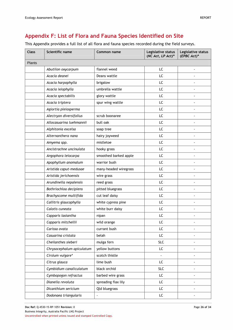
Ecology Assessment Report REPORT
Doc Ref: Q-4530-15-RP-1051 Revision: 0 Page 26 of 34
Business Integrity, Australia Pacific LNG Project
Uncontrolled when printed unless issued and stamped Controlled Copy.
Appendix F: List of Flora and Fauna Species Identified on Site
This Appendix provides a full list of all flora and fauna species recorded during the field surveys.
Class Scientific name Common name Legislative status (NC Act, LP Act)*
Legislative status (EPBC Act)*
Plants
Abutilon oxycarpum flannel weed LC -
Acacia deanei Deans wattle LC -
Acacia harpophylla brigalow LC -
Acacia ixiophylla umbrella wattle LC -
Acacia spectabilis glory wattle LC -
Acacia triptera spur wing wattle LC -
Agiortia pleiosperma LC -
Alectryon diversifolius scrub boonaree LC -
Allocasuarina luehmannii bull oak LC -
Alphitonia excelsa soap tree LC -
Alternanthera nana hairy joyweed LC -
Amyema spp. mistletoe LC -
Ancistrachne uncinulata hooky grass LC -
Angophora leiocarpa smoothed barked apple LC -
Apophyllum anomalum warrior bush LC -
Aristida caput-medusae many-headed wiregrass LC -
Aristida jerichoensis wire grass LC -
Arundinella nepalensis reed grass LC -
Bothriochloa decipiens pitted bluegrass LC -
Brachyscome multifida cut leaf daisy LC -
Callitris glaucophylla white cypress pine LC -
Calotis cuneata white burr daisy LC -
Capparis lasiantha nipan LC -
Capparis mitchellii wild orange LC -
Carissa ovata currant bush LC -
Casuarina cristata belah LC -
Cheilanthes sieberi mulga fern SLC -
Chrysocephalum apiculatum yellow buttons LC -
Cirsium vulgare* scotch thistle - -
Citrus glauca lime bush LC -
Cymbidium canaliculatum black orchid SLC -
Cymbopogon refractus barbed wire grass LC -
Dianella revoluta spreading flax lily LC -
Dicanthium sericium Qld bluegrass LC -
Dodonaea triangularis - LC -
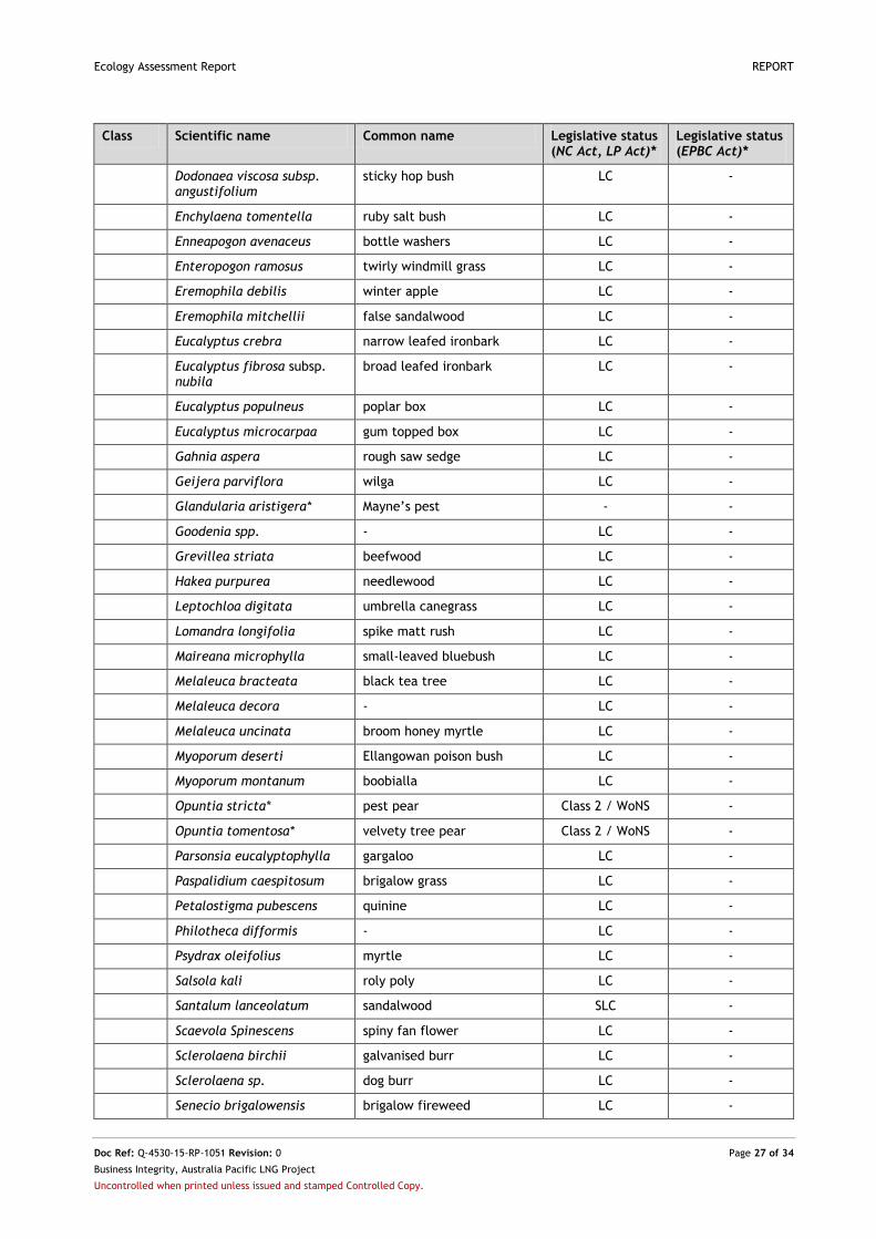
Ecology Assessment Report REPORT
Doc Ref: Q-4530-15-RP-1051 Revision: 0 Page 27 of 34
Business Integrity, Australia Pacific LNG Project
Uncontrolled when printed unless issued and stamped Controlled Copy.
Class Scientific name Common name Legislative status (NC Act, LP Act)*
Legislative status (EPBC Act)*
Dodonaea viscosa subsp. angustifolium
sticky hop bush LC -
Enchylaena tomentella ruby salt bush LC -
Enneapogon avenaceus bottle washers LC -
Enteropogon ramosus twirly windmill grass LC -
Eremophila debilis winter apple LC -
Eremophila mitchellii false sandalwood LC -
Eucalyptus crebra narrow leafed ironbark LC -
Eucalyptus fibrosa subsp. nubila
broad leafed ironbark LC -
Eucalyptus populneus poplar box LC -
Eucalyptus microcarpaa gum topped box LC -
Gahnia aspera rough saw sedge LC -
Geijera parviflora wilga LC -
Glandularia aristigera* Mayne’s pest - -
Goodenia spp. - LC -
Grevillea striata beefwood LC -
Hakea purpurea needlewood LC -
Leptochloa digitata umbrella canegrass LC -
Lomandra longifolia spike matt rush LC -
Maireana microphylla small-leaved bluebush LC -
Melaleuca bracteata black tea tree LC -
Melaleuca decora - LC -
Melaleuca uncinata broom honey myrtle LC -
Myoporum deserti Ellangowan poison bush LC -
Myoporum montanum boobialla LC -
Opuntia stricta* pest pear Class 2 / WoNS -
Opuntia tomentosa* velvety tree pear Class 2 / WoNS -
Parsonsia eucalyptophylla gargaloo LC -
Paspalidium caespitosum brigalow grass LC -
Petalostigma pubescens quinine LC -
Philotheca difformis - LC -
Psydrax oleifolius myrtle LC -
Salsola kali roly poly LC -
Santalum lanceolatum sandalwood SLC -
Scaevola Spinescens spiny fan flower LC -
Sclerolaena birchii galvanised burr LC -
Sclerolaena sp. dog burr LC -
Senecio brigalowensis brigalow fireweed LC -
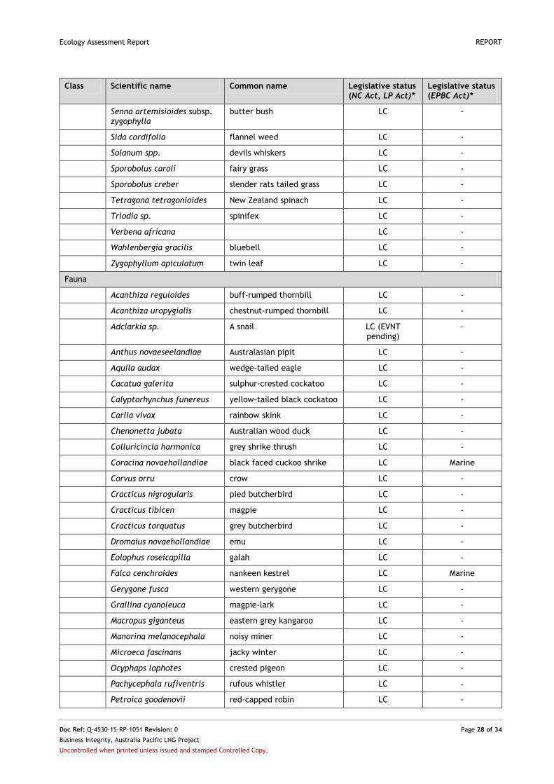
Ecology Assessment Report REPORT
Doc Ref: Q-4530-15-RP-1051 Revision: 0 Page 28 of 34
Business Integrity, Australia Pacific LNG Project
Uncontrolled when printed unless issued and stamped Controlled Copy.
Class Scientific name Common name Legislative status (NC Act, LP Act)*
Legislative status (EPBC Act)*
Senna artemisioides subsp. zygophylla
butter bush LC -
Sida cordifolia flannel weed LC -
Solanum spp. devils whiskers LC -
Sporobolus caroli fairy grass LC -
Sporobolus creber slender rats tailed grass LC -
Tetragona tetragonioides New Zealand spinach LC -
Triodia sp. spinifex LC -
Verbena africana LC -
Wahlenbergia gracilis bluebell LC -
Zygophyllum apiculatum twin leaf LC -
Fauna
Acanthiza reguloides buff-rumped thornbill LC -
Acanthiza uropygialis chestnut-rumped thornbill LC -
Adclarkia sp. A snail LC (EVNT pending)
-
Anthus novaeseelandiae Australasian pipit LC -
Aquila audax wedge-tailed eagle LC -
Cacatua galerita sulphur-crested cockatoo LC -
Calyptorhynchus funereus yellow-tailed black cockatoo LC -
Carlia vivax rainbow skink LC -
Chenonetta jubata Australian wood duck LC -
Colluricincla harmonica grey shrike thrush LC -
Coracina novaehollandiae black faced cuckoo shrike LC Marine
Corvus orru crow LC -
Cracticus nigrogularis pied butcherbird LC -
Cracticus tibicen magpie LC -
Cracticus torquatus grey butcherbird LC -
Dromaius novaehollandiae emu LC -
Eolophus roseicapilla galah LC -
Falco cenchroides nankeen kestrel LC Marine
Gerygone fusca western gerygone LC -
Grallina cyanoleuca magpie-lark LC -
Macropus giganteus eastern grey kangaroo LC -
Manorina melanocephala noisy miner LC -
Microeca fascinans jacky winter LC -
Ocyphaps lophotes crested pigeon LC -
Pachycephala rufiventris rufous whistler LC -
Petroica goodenovii red-capped robin LC -

Ecology Assessment Report REPORT
Doc Ref: Q-4530-15-RP-1051 Revision: 0 Page 29 of 34
Business Integrity, Australia Pacific LNG Project
Uncontrolled when printed unless issued and stamped Controlled Copy.
Class Scientific name Common name Legislative status (NC Act, LP Act)*
Legislative status (EPBC Act)*
Platycercus_adscitus pale-headed rosella LC -
Plectorhyncha lanceolata striped honeyeater LC -
Pomatostomus temporalis grey crowned babbler LC -
Merops ornatus rainbow bee-eater SLC Marine/Migratory
Northiella haematogaster blue bonnet LC -
Rhipidura albiscapa grey fantail LC -
Rhipidura leucophyrys willie wagtail LC -
Strepera graculina pied currawong LC -
Struthidea cinerea apostle bird LC -
Sus scrofa pig* - -
Taeniopygia bichenovii double-barred finch LC -
Vanellus tricolor banded lapwing LC -
Varanus sp. goanna LC -
*Status taken from EHP (2014) and DoE 2014
Ecology Assessment Report REPORT
Doc Ref: Q-4530-15-RP-1051 Revision: 0 Page 30 of 34
Business Integrity, Australia Pacific LNG Project
Uncontrolled when printed unless issued and stamped Controlled Copy.
Appendix G: Ground Truthed Threatened Ecological Communities
This Appendix provides mapping of all field validated EPBC TECs surveyed on site
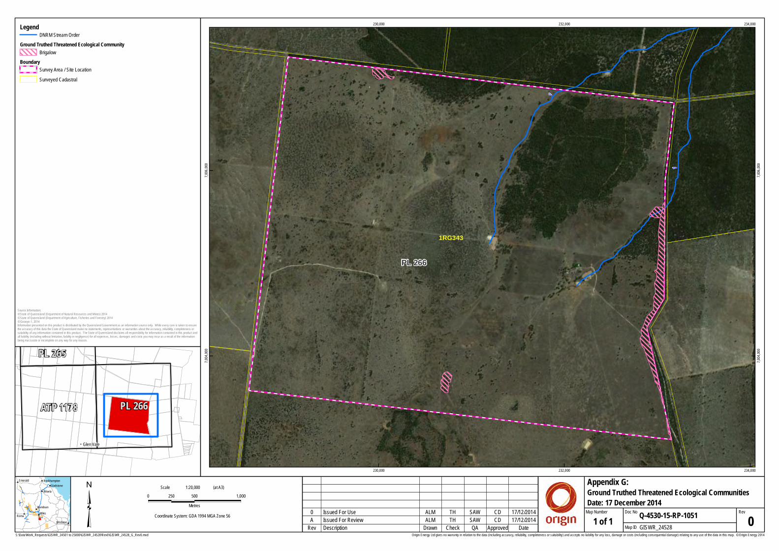
S:\Data\Work_Requests\GISWR_24501 to 25000\GISWR_24528\Rev0\GISWR_24528_G_Rev0.mxd
³ 0 500 1,000250Metres
Coordinate System: GDA 1994 MGA Zone 56
Origin Energy Ltd gives no warranty in relation to the data (including accuracy, reliability, completeness or suitability) and accepts no liability for any loss, damage or costs (including consequential damage) relating to any use of the data in this map. © Origin Energy 2014
PL 266
1
1
1RG343
230,000
230,000
232,000
232,000
234,000
234,000
7,004,
000
7,004,
000
7,006,
000
7,006,
000
ALM SAWTH CD
1:20,000Scale (at A3)
17/12/2014Description GISWR_24528Check Map IDDrawn QA Approved 1 of 1
Ground Truthed Threatened Ecological Communities
Rev Date
RevQ-4530-15-RP-1051
Appendix G:
Map Number Doc NoIssued For Review 0A
0 17/12/2014Issued For Use
SAW
CD
TH
ALM
Date: 17 December 2014
!
!
!
!!
!
!
!
Roma Miles
Biloela
Emerald
Wandoan
Brisbane
GladstoneRockhampton
Source Information:© State of Queensland (Department of Natural Resources and Mines) 2014© State of Queensland (Department of Agriculture, Fisheries and Forestry) 2014© Geoeye-1, 2014Information presented on this product is distributed by the Queensland Government as an information source only. While every care is taken to ensurethe accuracy of this data the State of Queensland make no statements, representations or warranties about the accuracy, reliability, completeness orsuitability of any information contained in this product. The State of Queensland disclaims all responsibility for information contained in this product andall liability (including without limitation, liability in negligence) for all expenses, losses, damages and costs you may incur as a result of the informationbeing inaccurate or incomplete on any way for any reason.
!! Glen Vale
ATP 1178
PL 265
PL 266
LegendDNRM Stream Order
Ground Truthed Threatened Ecological Community Brigalow
Boundary Survey Area / Site Location Surveyed Cadastral

Ecology Assessment Report REPORT
Doc Ref: Q-4530-15-RP-1051 Revision: 0 Page 31 of 34
Business Integrity, Australia Pacific LNG Project
Uncontrolled when printed unless issued and stamped Controlled Copy.
Appendix H: Ground Truthed Regional Ecosystems
This Appendix provides mapping of all field validated GTRE recorded on site.
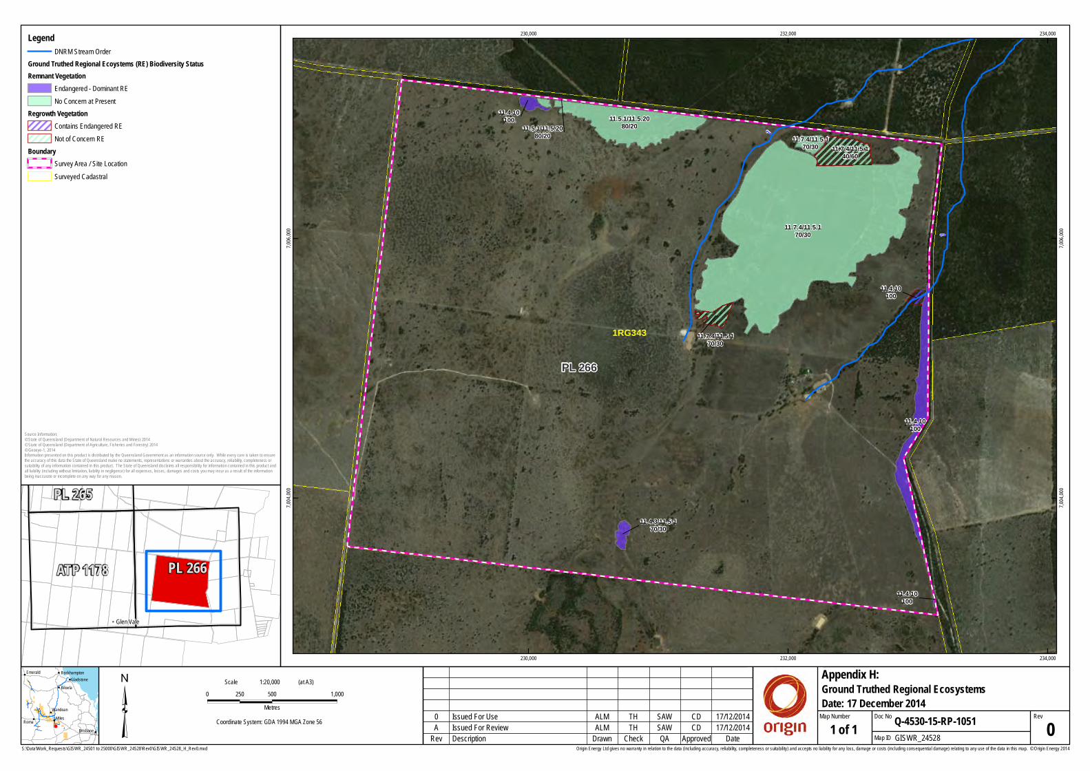
S:\Data\Work_Requests\GISWR_24501 to 25000\GISWR_24528\Rev0\GISWR_24528_H_Rev0.mxd
³ 0 500 1,000250Metres
Coordinate System: GDA 1994 MGA Zone 56
Origin Energy Ltd gives no warranty in relation to the data (including accuracy, reliability, completeness or suitability) and accepts no liability for any loss, damage or costs (including consequential damage) relating to any use of the data in this map. © Origin Energy 2014
11.4.3/11.5.170/30
11.5.1/11.5.2080/20
11.7.4/11.5.170/30
11.7.4/11.5.170/30
11.4.10100
11.4.10100
11.4.10100
11.7.4/11.5.140/60
11.4.10100
11.7.4/11.5.170/30
11.5.1/11.5.2080/20
PL 266
1
1
1RG343
230,000
230,000
232,000
232,000
234,000
234,000
7,004,
000
7,004,
000
7,006,
000
7,006,
000
ALM SAWTH CD
1:20,000Scale (at A3)
17/12/2014Description GISWR_24528Check Map IDDrawn QA Approved 1 of 1
Ground Truthed Regional Ecosystems
Rev Date
RevQ-4530-15-RP-1051
Appendix H:
Map Number Doc NoIssued For Review 0A
0 17/12/2014Issued For Use
SAW
CD
TH
ALM
Date: 17 December 2014
!
!
!
!!
!
!
!
Roma Miles
Biloela
Emerald
Wandoan
Brisbane
GladstoneRockhampton
Source Information:© State of Queensland (Department of Natural Resources and Mines) 2014© State of Queensland (Department of Agriculture, Fisheries and Forestry) 2014© Geoeye-1, 2014Information presented on this product is distributed by the Queensland Government as an information source only. While every care is taken to ensurethe accuracy of this data the State of Queensland make no statements, representations or warranties about the accuracy, reliability, completeness orsuitability of any information contained in this product. The State of Queensland disclaims all responsibility for information contained in this product andall liability (including without limitation, liability in negligence) for all expenses, losses, damages and costs you may incur as a result of the informationbeing inaccurate or incomplete on any way for any reason.
!! Glen Vale
ATP 1178
PL 265
PL 266
LegendDNRM Stream Order
Ground Truthed Regional Ecoystems (RE) Biodiversity Status Remnant Vegetation
Endangered - Dominant RENo Concern at Present
Regrowth VegetationContains Endangered RENot of Concern RE
Boundary Survey Area / Site Location Surveyed Cadastral
Ecology Assessment Report REPORT
Doc Ref: Q-4530-15-RP-1051 Revision: 0 Page 32 of 34
Business Integrity, Australia Pacific LNG Project
Uncontrolled when printed unless issued and stamped Controlled Copy.
Appendix I: Ground Truthed EPBC Threat Listed Species Present on Site
This Appendix provides mapping of all EPBC threat listed species recorded on site during the field survey.

S:\Data\Work_Requests\GISWR_24501 to 25000\GISWR_24528\Rev0\GISWR_24528_I_Rev0.mxd
³ 0 500 1,000250Metres
Coordinate System: GDA 1994 MGA Zone 56
Origin Energy Ltd gives no warranty in relation to the data (including accuracy, reliability, completeness or suitability) and accepts no liability for any loss, damage or costs (including consequential damage) relating to any use of the data in this map. © Origin Energy 2014
YXW
XW
XW
XW
XW
PL 2661RG343
230,000
230,000
232,000
232,000
234,000
234,000
7,004,
000
7,004,
000
7,006,
000
7,006,
000
ALM SAWTH CD
1:20,000Scale (at A3)
17/12/2014Description GISWR_24528Check Map IDDrawn QA Approved 1 of 1
Ground Truthed EPBC Threat Listed Species Present on Site
Rev Date
RevQ-4530-15-RP-1051
Appendix I:
Map Number Doc NoIssued For Review 0A
0 17/12/2014Issued For Use
SAW
CD
TH
ALM
Date: 17 December 2014
!
!
!
!!
!
!
!
Roma Miles
Biloela
Emerald
Wandoan
Brisbane
GladstoneRockhampton
Source Information:© State of Queensland (Department of Natural Resources and Mines) 2014© State of Queensland (Department of Agriculture, Fisheries and Forestry) 2014© Geoeye-1, 2014Information presented on this product is distributed by the Queensland Government as an information source only. While every care is taken to ensurethe accuracy of this data the State of Queensland make no statements, representations or warranties about the accuracy, reliability, completeness orsuitability of any information contained in this product. The State of Queensland disclaims all responsibility for information contained in this product andall liability (including without limitation, liability in negligence) for all expenses, losses, damages and costs you may incur as a result of the informationbeing inaccurate or incomplete on any way for any reason.
!! Glen Vale
ATP 1178
PL 265
PL 266
LegendGround Truthed EPBC Threat Listed Species XW Rainbow Bee-Eater (Merops ornatus)XW Nankeen Kestrel (Falco cenchroides)XW Magpie-Lark (Grallina cyanoleuca)
Y Black-Faced Cuckoo-Shrike (Coracina novaehollandiae)
Boundary Survey Area / Site Location Surveyed Cadastral
Ecology Assessment Report REPORT
Doc Ref: Q-4530-15-RP-1051 Revision: 0 Page 33 of 34
Business Integrity, Australia Pacific LNG Project
Uncontrolled when printed unless issued and stamped Controlled Copy.
Appendix J: Ground Truthed NC Act Threat Listed Species Present on Site
This Appendix provides mapping of all field validated NC Act threat listed species recorded on site.
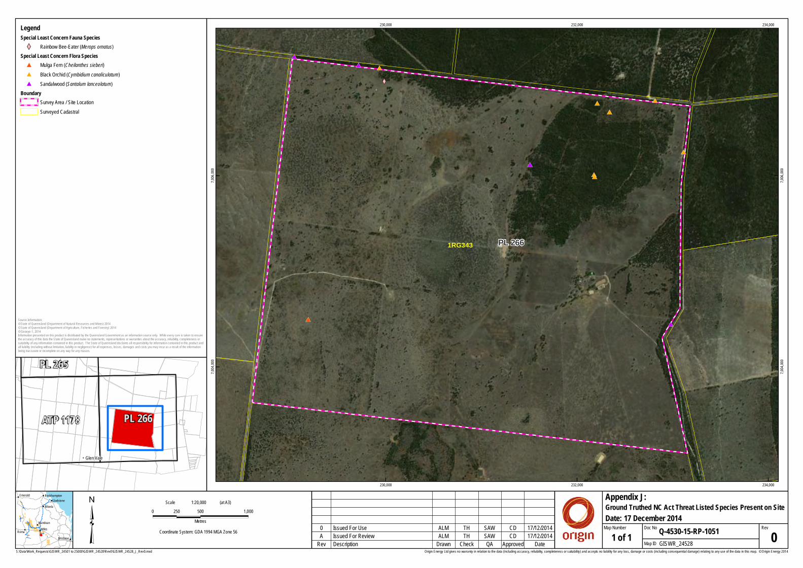
S:\Data\Work_Requests\GISWR_24501 to 25000\GISWR_24528\Rev0\GISWR_24528_J_Rev0.mxd
³ 0 500 1,000250Metres
Coordinate System: GDA 1994 MGA Zone 56
Origin Energy Ltd gives no warranty in relation to the data (including accuracy, reliability, completeness or suitability) and accepts no liability for any loss, damage or costs (including consequential damage) relating to any use of the data in this map. © Origin Energy 2014
#*
#*#*
#*
#*
#*
#*
#*
#*
#*
#*
#*
XW
PL 2661RG343
230,000
230,000
232,000
232,000
234,000
234,000
7,004,
000
7,004,
000
7,006,
000
7,006,
000
ALM SAWTH CD
1:20,000Scale (at A3)
17/12/2014Description GISWR_24528Check Map IDDrawn QA Approved 1 of 1
Ground Truthed NC Act Threat Listed Species Present on Site
Rev Date
RevQ-4530-15-RP-1051
Appendix J:
Map Number Doc NoIssued For Review 0A
0 17/12/2014Issued For Use
SAW
CD
TH
ALM
Date: 17 December 2014
!
!
!
!!
!
!
!
Roma Miles
Biloela
Emerald
Wandoan
Brisbane
GladstoneRockhampton
Source Information:© State of Queensland (Department of Natural Resources and Mines) 2014© State of Queensland (Department of Agriculture, Fisheries and Forestry) 2014© Geoeye-1, 2014Information presented on this product is distributed by the Queensland Government as an information source only. While every care is taken to ensurethe accuracy of this data the State of Queensland make no statements, representations or warranties about the accuracy, reliability, completeness orsuitability of any information contained in this product. The State of Queensland disclaims all responsibility for information contained in this product andall liability (including without limitation, liability in negligence) for all expenses, losses, damages and costs you may incur as a result of the informationbeing inaccurate or incomplete on any way for any reason.
!! Glen Vale
ATP 1178
PL 265
PL 266
LegendSpecial Least Concern Fauna Species XW Rainbow Bee-Eater (Merops ornatus)
Special Least Concern Flora Species #* Mulga Fern (Cheilanthes sieberi)#* Black Orchid (Cymbidium canaliculatum)#* Sandalwood (Santalum lanceolatum)
Boundary Survey Area / Site Location Surveyed Cadastral

Ecology Assessment Report REPORT
Doc Ref: Q-4530-15-RP-1051 Revision: 0 Page 34 of 34
Business Integrity, Australia Pacific LNG Project
Uncontrolled when printed unless issued and stamped Controlled Copy.
Appendix K: Ground Truthed Weeds and Pest Fauna Present on Site
This Appendix provides mapping of all ground truthed weeds and pest fauna surveyed on site.
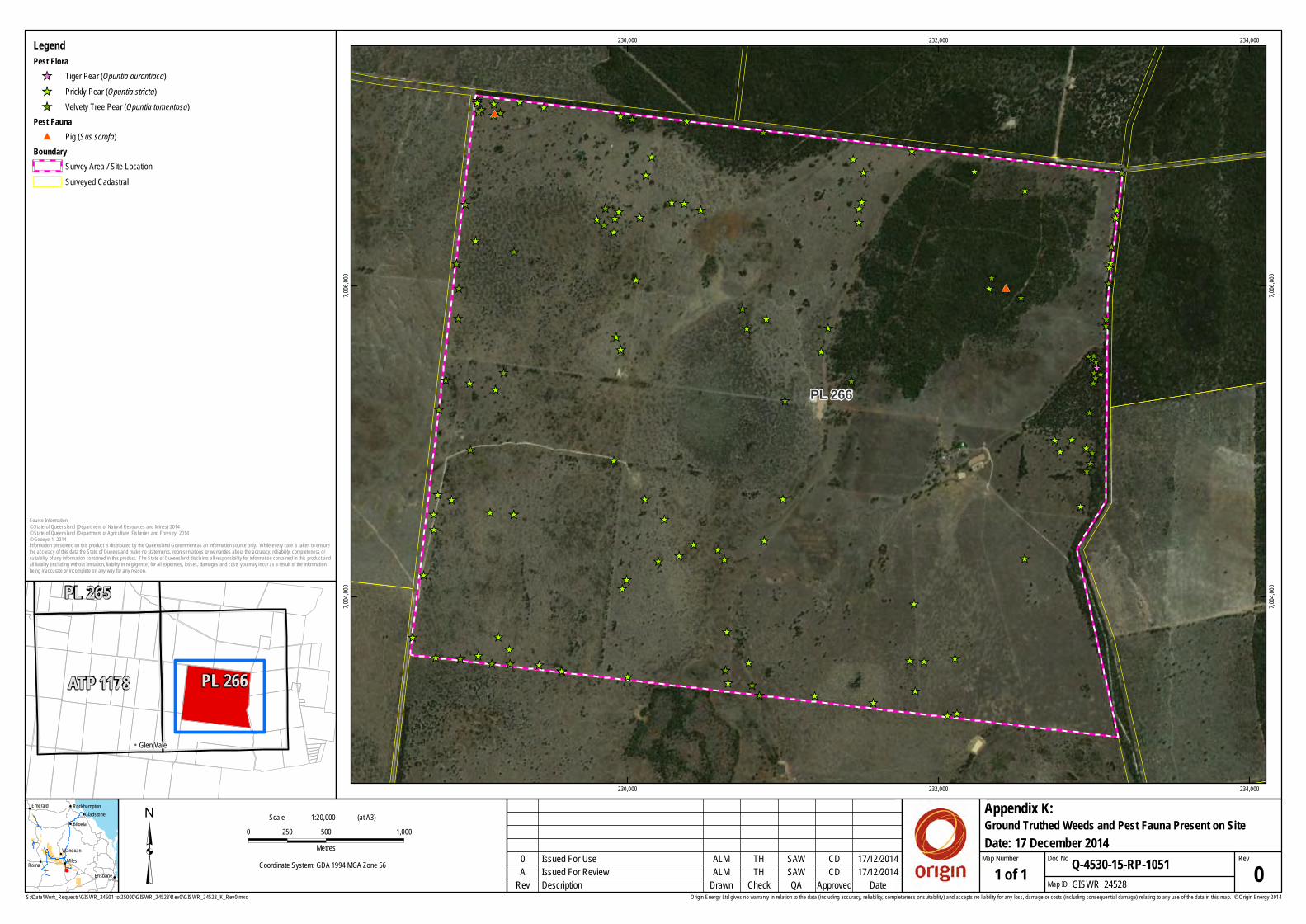
S:\Data\Work_Requests\GISWR_24501 to 25000\GISWR_24528\Rev0\GISWR_24528_K_Rev0.mxd
³ 0 500 1,000250Metres
Coordinate System: GDA 1994 MGA Zone 56
Origin Energy Ltd gives no warranty in relation to the data (including accuracy, reliability, completeness or suitability) and accepts no liability for any loss, damage or costs (including consequential damage) relating to any use of the data in this map. © Origin Energy 2014
_̂̂__̂
_̂_̂̂__̂
_̂̂__̂
_̂_̂ _̂
_̂
_̂_̂
_̂_̂̂_
_̂
_̂
_̂_̂_̂
_̂_̂_̂
_̂
_̂_̂̂_
_̂
_̂_̂_̂
_̂_̂
_̂_̂
_̂
_̂
_̂_̂
_̂
_̂_̂
_̂ _̂̂__̂
_̂
_̂
_̂ _̂̂_ _̂_̂ _̂
_̂_̂
_̂ _̂̂_ _̂
_̂_̂
_̂
_̂
_̂
_̂
_̂
_̂
_̂̂_ _̂_̂
_̂
_̂
_̂
_̂̂_
_̂
_̂_̂
_̂̂_ _̂_̂̂_̂_
_̂ _̂
_̂_̂
_̂
_̂
_̂̂_
_̂_̂_̂̂__̂̂_
_̂
_̂
_̂_̂
_̂_̂
_̂_̂
_̂
_̂
_̂_̂
_̂
_̂
_̂
_̂
_̂
_̂_̂
_̂
_̂̂_̂_
_̂
_̂_̂_̂
_̂
_̂_̂_̂
_̂
_̂
_̂
_̂
_̂_̂_̂_̂
_̂
#*
#*
PL 266
230,000
230,000
232,000
232,000
234,000
234,000
7,004,
000
7,004,
000
7,006,
000
7,006,
000
ALM SAWTH CD
1:20,000Scale (at A3)
17/12/2014Description GISWR_24528Check Map IDDrawn QA Approved 1 of 1
Ground Truthed Weeds and Pest Fauna Present on Site
Rev Date
RevQ-4530-15-RP-1051
Appendix K:
Map Number Doc NoIssued For Review 0A
0 17/12/2014Issued For Use
SAW
CD
TH
ALM
Date: 17 December 2014
!
!
!
!!
!
!
!
Roma Miles
Biloela
Emerald
Wandoan
Brisbane
GladstoneRockhampton
Source Information:© State of Queensland (Department of Natural Resources and Mines) 2014© State of Queensland (Department of Agriculture, Fisheries and Forestry) 2014© Geoeye-1, 2014Information presented on this product is distributed by the Queensland Government as an information source only. While every care is taken to ensurethe accuracy of this data the State of Queensland make no statements, representations or warranties about the accuracy, reliability, completeness orsuitability of any information contained in this product. The State of Queensland disclaims all responsibility for information contained in this product andall liability (including without limitation, liability in negligence) for all expenses, losses, damages and costs you may incur as a result of the informationbeing inaccurate or incomplete on any way for any reason.
!! Glen Vale
ATP 1178
PL 265
PL 266
LegendPest Flora _̂ Tiger Pear (Opuntia aurantiaca)_̂ Prickly Pear (Opuntia stricta)_̂ Velvety Tree Pear (Opuntia tomentosa)
Pest Fauna #* Pig (Sus scrofa)
Boundary Survey Area / Site Location Surveyed Cadastral