Embed Size (px)
Citation preview
No. 39 • April 2021
MAKE EVERY DR P C UNT,
AND C UNT EVERY DR P:
VANISHING GR UNDWATER NEEDS PR PER M NIT RING
AND MANAGEMENT
Grahame Campbell

POLICY Paper 39
Make every drop count, and count every drop: Vanishing groundwater
needs proper monitoring and management
Grahame Campbell
ContentsExecutive summary ................................................................................................................................. 1
Current Status of Groundwater Use and Management ................................................................................... 2
Groundwater extraction ................................................................................................................... 2
Groundwater monitoring system and technology ................................................................................. 3
Groundwater management and stakeholder involvement ...................................................................... 3
Case studies ........................................................................................................................................... 4
Namoi Catchment ........................................................................................................................... 4
Surat Basin .................................................................................................................................... 4
Conclusion and proposals ......................................................................................................................... 5
Endnotes ............................................................................................................................................... 6
1
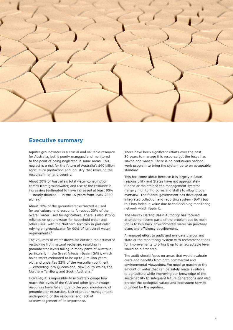
Aquifer groundwater is a crucial and valuable resource for Australia, but is poorly managed and monitored to the point of being neglected in some areas. This neglect is a risk for the future of Australia’s $60 billion agriculture production and industry that relies on the resource in an arid country.
About 30% of Australia’s total water consumption comes from groundwater, and use of the resource is increasing (estimated to have increased at least 90% — nearly doubled — in the 15 years from 1985-2000 alone).1
About 70% of the groundwater extracted is used for agriculture, and accounts for about 30% of the overall water used for agriculture. There is also strong reliance on groundwater for household water and other uses, with the Northern Territory in particular relying on groundwater for 90% of its overall water requirements.2
The volumes of water drawn far outstrip the estimated restocking from natural recharge, resulting in groundwater levels falling in many parts of Australia; particularly in the Great Artesian Basin (GAB), which holds water estimated to be up to 2 million years old, and underlies 22% of the Australian continent — extending into Queensland, New South Wales, the Northern Territory, and South Australia.3
However, it is impossible to accurately gauge how much the levels of the GAB and other groundwater resources have fallen, due to the poor monitoring of groundwater extraction, lack of proper management, underpricing of the resource, and lack of acknowledgement of its importance.
There have been significant efforts over the past 30 years to manage this resource but the focus has waxed and waned. There is no continuous national work program to bring the system up to an acceptable standard.
This has come about because it is largely a State responsibility and States have not appropriately funded or maintained the management systems (largely monitoring bores and staff) to allow proper overview. The federal government has developed an integrated collection and reporting system (BoM) but this has faded in value due to the declining monitoring network which feeds it.
The Murray Darling Basin Authority has focused attention on some parts of the problem but its main job is to buy back environmental water via purchase plans and efficiency development.
A renewed effort to audit and evaluate the current state of the monitoring system with recommendations for improvements to bring it up to an acceptable level would be a first step.
The audit should focus on areas that would evaluate costs and benefits from both commercial and environmental viewpoints. We need to maximise the amount of water that can be safely made available to agriculture while improving our knowledge of the sustainability to safeguard future generations and also protect the ecological values and ecosystem service provided by the aquifers.
Executive summary
2
Between 2004 and 2006, the federal government and all state and territory governments signed the National Water Initiative (NWI), reinvigorating coordinated national water reforms. Broadly, the NWI sought to improve water governance, and the efficiency, productivity, and environmental sustainability of water use. Among other things, it focused on achieving transparent and statute-based water planning, nationally compatible water access entitlements, integrated management of surface water and groundwater, resolution of water over-allocation and over-use, effective water accounting, and open water markets. The National Water Commission was established in 2004 to oversee the reforms.
The 2007 Water Act gave regulatory teeth to elements of the NWI, at least in the Murray-Darling Basin. Contrary to common views, parts of the Water Act also apply outside the Murray-Darling Basin. The Act grants substantial powers to the Bureau of Meteorology in relation to collecting and disseminating information about groundwater around the nation,
much of which had been buried in paper files at state and local water agencies.
Though less sensational than reining in water use in the Murray-Darling Basin, the creation of an easily accessible repository of groundwater information provided vital support to agencies and businesses for understanding and managing groundwater resources. Unfortunately all of this activity faded away from 2013.
This is surprising given that children are taught from an early age that water is a precious commodity in the world’s driest continent.
Groundwater extraction
About 30% of Australia’s total water consumption comes from groundwater, and use of the resource is increasing (estimated to have increased at least 90%, nearly doubled, in just the 15 years from 1985-2000 alone).4
Current Status of Groundwater Use and Management
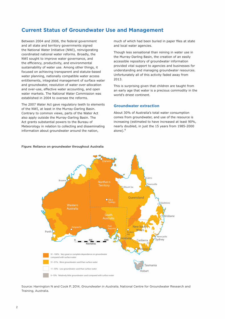
Source: Harrington N and Cook P, 2014, Groundwater in Australia, National Centre for Groundwater Research and Training, Australia.
Figure: Reliance on groundwater throughout Australia
9
ROU
ND
WATER IN
AU
STRALIA
NATIONAL CENTRE FOR GROUNDWATER RESEARCH AND TRAINING
Kilometres
500 10000 Adelaide
Darwin
Perth
Hobart
Melbour ne
Canberra
Brisbane
Sydney
TownsvilleMount Isa
Cairns
Gladstone
Newcastle
Broome
Kalgoorlie PortAugusta
BrokenHill
AliceSprings
Norther nTerritory
WesternAustralia
SouthAustralia
Queensland
New SouthWales
Victoria
Tasmania
Figure 4c. Groundwater use at a national scale as a percentage of total water use (AWRC, 1981; CSIRO, 2008; CSIRO, 2009a–e; Barron et al., 2011; NT Department of Land Resource Management, pers. comm., 4 Sept 2013; WA Department of Water, pers. comm., 23 Oct 2013) 6.
6Note: this figure is based upon the original AWRC map from 1981, with more recent data added where available as per the references provided. The divisions used in the original map were based upon drainage divisions, and extra detail has been added to this based upon the references provided.
91–100%: Very great or complete dependence on groundwater compared with surface water
51–91%: More groundwater used than surface water
11–50%: Less groundwater used than surface water
0–10%: Relatively little groundwater used compared with surface water 9
ROU
ND
WATER IN
AU
STRALIA
NATIONAL CENTRE FOR GROUNDWATER RESEARCH AND TRAINING
Kilometres
500 10000 Adelaide
Darwin
Perth
Hobart
Melbour ne
Canberra
Brisbane
Sydney
TownsvilleMount Isa
Cairns
Gladstone
Newcastle
Broome
Kalgoorlie PortAugusta
BrokenHill
AliceSprings
Norther nTerritory
WesternAustralia
SouthAustralia
Queensland
New SouthWales
Victoria
Tasmania
Figure 4c. Groundwater use at a national scale as a percentage of total water use (AWRC, 1981; CSIRO, 2008; CSIRO, 2009a–e; Barron et al., 2011; NT Department of Land Resource Management, pers. comm., 4 Sept 2013; WA Department of Water, pers. comm., 23 Oct 2013) 6.
6Note: this figure is based upon the original AWRC map from 1981, with more recent data added where available as per the references provided. The divisions used in the original map were based upon drainage divisions, and extra detail has been added to this based upon the references provided.
91–100%: Very great or complete dependence on groundwater compared with surface water
51–91%: More groundwater used than surface water
11–50%: Less groundwater used than surface water
0–10%: Relatively little groundwater used compared with surface water
3
About 70% of the groundwater extracted is used for agriculture, and accounts for about 30% of the overall water used for agriculture. In 2018-19, 8 million megalitres of water overall was used in agricultural production, of which 2.3 million megalitres was groundwater (a rise of 6%).5 However, Harrington and Cook state there is wide belief that actual groundwater use may be up to double this figure.6
There is also strong reliance on groundwater for household water and other uses, such as industry. The Northern Territory relies on groundwater for 90% of its overall water requirements, followed by Western Australia (around 63%), New South Wales (around 36%) and Queensland (32%).7
There is growing concern about the impact of falling groundwater levels resulting from increased extraction far outstripping recharging of aquifers — calling into question the sustainability of the resource particularly as the lack of monitoring has allowed over-allocation and underpriced or free extraction8
Groundwater overuse is a particularly thorny issue in the context of aquifers that were recharged during different geologic periods and climates, and are no longer actively recharged — for example, the Great Artesian Basin and the Murray Group Limestone aquifer that straddles the Victoria-South Australia border. In such areas, groundwater extraction permanently depletes, or ‘mines’ the resource. This ‘fossil’ groundwater supports around $25 billion (one-third) of Australian mineral exports, as well as many homesteads, towns, mines, and pastoral enterprises in this arid zone.
The key management issue is setting an acceptable rate of aquifer depletion, which involves considering the appropriate planning horizon, the direct and indirect costs and benefits of depletion to present and future generations, strategies for coping with post-depletion water scarcity, the protection of any ecosystems and cultural values that depend on the resource, public participation requirements, and appropriate monitoring strategies.
Groundwater monitoring system and technology
Australia’s network of 23,000 monitoring bores is key to the information needed for current and future management of groundwater. However, the ageing network requires a thorough assessment to identify monitoring failures and gaps.9 With better data we can develop better management.
As Rebecca Nelson noted:
In adopting a focus on controlling extraction, policy-makers have tended to overlook groundwater management approaches that rely on infrastructure or more active management. At least two notable opportunities arise in connection with a more active management approach: managed aquifer recharge
(MAR) and conjunctive water management strategies.
Conjunctive water management strategically takes advantage of the different attributes of groundwater and surface water. For example, accessing and alternating between surface water and groundwater can increase water security and business flexibility, and engineering technologies can use aquifer storage space to maintain or enhance in-stream flows.10
There is general consensus that groundwater monitoring needs a significant audit and considerable support to bring it up to a competent management tool for good governance. It’s not clear that new thinking on the ability to evaluate the current available data is driven by necessity or the belief that acceptable results can be produced by innovation.
There has also been government reluctance or resistance to taking on board the local knowledge of water users in several important aquifer areas, such as the Namoi.
However, the Surat Basin seems to be the most comprehensive analysis of groundwater management in Australia, with extensive monitoring and modelling of extraction and recharge rates.11 Work done in the Surat basin over the past decade could provide a template for an audit to be conducted throughout Australia’s groundwater resources.
An assessment of groundwater monitoring technology by Sinclair Knight Merz (SKM) judged monitoring bores to be the “most reliable and low maintenance way to monitor resource condition in terms of cost, longevity, repeatability, and the ability to be implemented by jurisdictional or regional stakeholders—86% of monitoring data is collected through manual monitoring.”12
While remote sensing has been suggested as a solution for aquifers with a high distribution of extraction points, metered points remain the most accurate method for gauging groundwater use.
Remote technology has been implemented on only a small percentage of the monitoring bores, with dataloggers on 9% and telemetry on 5%, however this allows more frequent monitoring without the need to continually visit distant locations in widely-dispersed rural areas.
The reducing number, and growing deterioration, of monitoring bores was highlighted in a report by GHD on groundwater management in the Murray-Darling Basin, which found there was “increasing focus by states to rationalise monitoring networks for economic reasons” which undermined the ability to identify problems as they emerged. The report urged “regular revision of management plans, monitoring networks and underlying numerical models based on updated monitoring data,” citing scarcity and maintenance of the monitoring network bores as key issues.13
SKM further estimated in 2011 that an additional $52 million annually was required to repair and replace
4
failing monitoring bores and conduct appropriate monitoring and maintenance — a 33% increase of federal funding — of which $36 million annually would be needed for planning and management that includes identifying groundwater planning as a separate component of overall water planning for “effective cost recovery.” However, a more considerable investment of $872 million would be needed if deterioration reached a stage where complete replacement was needed.14
Groundwater management and stakeholder involvement
Appropriate and effective management of both the groundwater and the monitoring networks can only be implemented when there is clarity about the objectives and responsibilities for all parties, including government departments, farmers and industries. The capture and inclusion of local knowledge would also reduce the risks inherent in relying on the currently-
incomplete monitoring data as the basis of making decisions.15
Community and stakeholder engagement is crucial in the decision-making and management process, and should be integrated into considerations of the “wider context of surface water connections, catchment management and cross-sectoral issues with economics, energy, climate, agriculture and the environment.”16
A disturbing trend in Australia is that we are losing our capability to study the problem as universities are cutting back on groundwater courses as funding dries up. R&D has been reduced and when we hit crisis levels in the future, which we most certainly will, we will have to engage overseas expertise which will take time to acclimatise to Australian conditions.
A little foresight could avoid the problem by setting up a key team to map out the work programmes to fill in the knowledge gaps.
Case studies
Case studies below will examine contrasts in management between the Great Artesian Basin’s sub-areas of the Namoi catchment and Surat basin.
Namoi Catchment
The Namoi catchment Water Sharing Plan (WSP) was completed after the overarching National Water Initiative (NWI) was finalised, and hence the NWI offered little information covering the connectivity between the groundwater system and the — usually dry — single riverbed above it, in a region where over-allocation of groundwater has become a serious problem.17
This problem is compounded by long periods of lag in obtaining sufficient data, with two decades of extraction in the Namoi Catchment before there was enough data to map the holdings and analyse the impact of extraction.
CSIRO noted that increased dedicated monitoring was needed “at a higher frequency along other reaches of the river network” as the reduced levels in the aquifer will result in “depletion of the river baseflow” itself, and that the past decade of groundwater extraction for irrigation has already caused depletion in the Namoi River.18
The results presented show that further research is required on the delivery and usage of water, at different times and to different locations, to achieve both goals of supporting irrigated agriculture and protecting groundwater-dependent ecosystems. This
can be more readily achieved if surface-water and groundwater are managed as a single resource at the catchment scale. We now have enough knowledge of the effects of groundwater withdrawals and their impacts on groundwater level, and on stream-and-aquifer interaction. This facilitates research opportunities on optimising the conjunctive use of surface-water and groundwater, while considering the ecological impacts.19
Surat Basin
The Surat Cumulative Management Area (CMA) contains around 22,500 bores. Around 8,100 draw from the Great Artesian Basin largely for stock and domestic (S&D), stock intensive, industrial and town water supply. About 13,500 bores access the overlying alluvium (mainly the Condamine Alluvium) and tertiary basalts for irrigation and S&D purposes. The remaining 900 or so bores access the underlying Bowen Basin. The majority of groundwater extraction — other than that used in coal-seam gas production is not metered, leading to “a high degree of uncertainty in relation to actual use.”20
Ongoing research by the Office of Groundwater Impact Assessment (OGIA) and others, using scientific assessment and additional datasets acquired since the previous report three years earlier, was reported in 2019 to have improved understanding of the geology and groundwater flow systems in the Surat basin. It also allowed redevelopment of the geological model incorporating up-to-date mapping and coal seam gas
5
While the changes on the demand side can probably be predicted with reasonable certainty, the processes that govern groundwater recharge are highly non-linear in both time and space; and rely on rainfall amounts, distribution, intensity, frequency, temperature, evapotranspiration and soil moisture processes.
Because of the spatio-temporal variabilities and non-linear processes (small changes in climate variables may lead to large changes in recharge), we will likely be saddled with large uncertainties on recharge estimates.
A pragmatic solution to this problem is to determine the actual recharge by monitoring groundwater levels and to use the data for adaptive management. As we are recognising the role of groundwater for ecosystem services, groundwater-dependent ecosystems, and providing baseflow to streams, we should reconsider how we strategically locate our future groundwater monitoring networks to also monitor the health of ecosystems and impacts on ecosystem processes.
New or updated bore networks therefore need to be optimised to both monitor the state of the resource as well as impacts on ecological assets. Individual bores also need to be designed and optimised for both water level and water quality monitoring, whereas focus in the past has primarily been on water levels. To support this report research into a number of issues should be initiated
1. Estimates of the spatial and temporal variability of groundwater recharge (the rate of recharge is the key sustainability parameter rather than aquifer volumes).
2. Ecological impacts of groundwater drawdown and better methods for determining environmental water requirements and determining the true costs
of environmental degradation due to groundwater depletion.
3. Water quality changes (deterioration) due to groundwater depletion as well as changes in physical water management (e.g. water quality changes caused by managed aquifer recharge schemes).
4. Cost-benefit analysis of the true value of groundwater and processes it supports (including environmental, ecological social and cultural).
5. Sociological studies of alternative governance and management strategies (e.g. cooperatives etc.).
Next steps
1. Develop scope of work for design of monitoring system described above including timing of work to review progressive updates.
2. Award contract
3. Review outcomes and develop construction plan.
4. Award sub contracts on an aquifer basis to install monitoring system.
5. Review effectiveness of work on a regular basis.
A higher level review of aquifer connectivity and its effects should be studied as data emerges from the work.
We spend billions of dollars on social programmes which will be wasted if we run out of potable water. Groundwater is a key part of the overall system and needs to be studied deeply to properly manage a sustainable future for our country.
Conclusion and proposals
(CSG) well and geophysical data in “a complex model that simulates 34 layers of geological strata over a large area – about 450 x 650 km.”21
The 2019 report noted that the monitoring network would be increased from the then approximately 600 monitoring points to 622 groundwater level and 103 water chemistry monitoring points — a 10% increase on the 2016 specification. There is also provision for ongoing replacement of monitoring bores that are no longer suitable.
This improvement in monitoring is used to more accurately calibrate the groundwater flow model, produce more accurate estimations of groundwater extraction and aquifer levels, and also inform the
efficiency and effectiveness of reinjection schemes in the basin. The results suggest that groundwater declines are likely to be caused by non-CSG extraction from the Hutton Sandstone aquifer, and that reinjection is the leading positive effect on water levels.
The model is also the basis for predicting impacts from existing and planned CSG projects — both in the short- and long-term (in which a water level decline of more than five metres is predicted) — which informs proactive ‘make good’ mitigation or reinjection arrangements. This saw 100 new bores added to the 122 previously identified with short-term impacts, with 88 assessed and 99 ‘make good’ reinjection arrangements reported as being implemented.22
1 Groundwater Use. https://www.ga.gov.au/scientific-topics/water/groundwater/basics/groundwater-use
2 Harrington N and Cook P, 2014, Groundwater in Australia, National Centre for Groundwater Research and Training, Australia
3 Jakeman A.J, Barreteau O, Hunt R.J, Rinaudo J-D, Ross A, Arshad M, and Hamilton S. Integrated Groundwater Management (IGM) An Overview of Concepts and Challenges 2018
4 Groundwater Use. https://www.ga.gov.au/scientific-topics/water/groundwater/basics/groundwater-use
5 Water Use on Australian Farms https://www.abs.gov.au/statistics/industry/agriculture/water-use-australian-farms/latest-release (May 2020)
6 Harrington N and Cook P, 2014, Groundwater in Australia, National Centre for Groundwater Research and Training, Australia
7 Ibid.
8 Jakeman A.J, Barreteau O, Hunt R.J, Rinaudo J-D, Ross A, Arshad M, and Hamilton S. Integrated Groundwater Management (IGM) An Overview of Concepts and Challenges 2018
9 Waterlines Report Series No 90, September 2012. Sinclair Knight Merz
10 Nelson R. Groundwater Hidden promise, hidden perils – CEDA. https://www.yumpu.com/en/document/view/37331996/groundwater-hidden-promise-hidden-perils-ceda. pp1, 12
11 UWIR Surat basin 2019. Third Underground Water Impact Report
12 Waterlines Report Series No 90, September 2012. Sinclair Knight Merz
13 GHD, Hydrosimulations, Hamstead Consulting: Approaches to Achieve Sustainable Use and Management of Groundwater Resources in the Murray–Darling Basin Using Rules and Resource
Condition Limits https://www.mdba.gov.au/sites/default/files/pubs/Approaches-to-achieve-sustainable-groundwater-management.PDF
14 Waterlines Report Series No 90, September 2012. Sinclair Knight Merz
15 GHD, Hydrosimulations, Hamstead Consulting: Approaches to Achieve Sustainable Use and Management of Groundwater Resources in the Murray–Darling Basin Using Rules and Resource Condition Limits https://www.mdba.gov.au/sites/default/files/pubs/Approaches-to-achieve-sustainable-groundwater-management.PDF
16 Jakeman A.J, Barreteau O, Hunt R.J, Rinaudo J-D, Ross A, Arshad M, and Hamilton S. Integrated Groundwater Management (IGM) An Overview of Concepts and Challenges 2018
17 G Kuehne, H Bjornlund: Frustration, Confusion and Uncertainty: Qualitative Responses from Namoi Valley Irrigators. 2006. https://www.researchgate.net/publication/228384776_Frustration_confusion_and_uncertainty_qualitative_responses_from_Namoi_Valley_irrigators’
18 Kelly B. F. J., Timms W. A. , Andersen M. S., McCallum A. M., Blakers R. S., Smith R., Rau G. C., Badenhop A., Ludowici K. and Acworth R. I. Aquifer heterogeneity and response time: the challenge for groundwater management. Crop and Pasture Science 64(12) 1141-1154. https://doi.org/10.1071/CP13084 64, 1141–1154
19 Ibid. https://doi.org/10.1071/CP13084 6 November 2013. https://www.publish.csiro.au/cp/Fulltext/cp13084
20 Office of Groundwater Impact Assessment: Underground Water Impact Report for the Surat Cumulative Management Area. 2019. https://www.resources.qld.gov.au/__data/assets/pdf_file/0019/1461241/uwir-full-report.pdf
21 Ibid.
22 Ibid.
Endnotes
6
Level 1, 131 Macquarie St, Sydney NSW 2000 • phone: 02 9438 4377 • email: [email protected]
POLICY Paper 39 (PP39) • ISSN: 2209-2447 • ISBN: 978-1-925744-79-8
Published April 2021 by the Centre for Independent Studies Limited. Views expressed are those of the authors and do not necessarily reflect the views of the Centre’s staff, advisors, directors or officers.
© Centre for Independent Studies (ABN 15 001 495 012)
This publication is available from the Centre for Independent Studies. Visit cis.org.au
About the Author
Grahame CampbellGrahame Campbell served as the Managing Director of CMPS&F – one of the largest engineering and project management groups in Australia – from 1987 to 1995. He is a past president of the Association of Consulting Engineers in Australia and the Australian Pipeline Industry Association, a past member of the Pacific Basin Economic Council and a Fellow of the Royal Society NSW (FRSN). He is an Honorary Fellow of the Institution of Engineers Australia and holds Bachelor of Engineering and Master of Engineering Science degrees from the University of New South Wales.
Related Works
Roger Bate, All the Water in the World, Policy Monographs 71, August 2006. cis.org.au/publications/policy-monographs/all-the-water-in-the-world/
Rebecca Gill, Droughts and Flooding Rains: Water Provision for a Growing Australia, Policy Monographs 115, July 2015. cis.org.au/app/uploads/2015/07/pm115.pdf