Embed Size (px)
Citation preview
Director’s Report:
CRTN, Epoch Update & Dynamic Datum
Yehuda Bock
California Spatial Reference Center (CSRC)
Scripps Orbit and Permanent Array Center (SOPAC)
Institute of Geophysics and Planetary Physics (IGPP)
Scripps Institution of Oceanography (SIO)
University of California San Diego (UCSD)
May 4, 2017
IGPP, La Jolla
Summary
• CRTN update
• Status 2017.00 epoch date for California
• Dynamic datum
• Earthquake and Local Tsunami Early Warning System

Director: Yehuda Bock
Coordinator: Maria Turingan
Analysis: Peng Fang
System Administrator: Anne Sullivan
Programmers: Allen Nance, TBD
Archivist & Web Admin: TBD
CRTN Engineer: Matt Norenberg
Graduate Students: Dara Goldberg, Lauren Coden, Minghua Wang
Consultant: John Canas, PLS
SOPAC/CSRC Group
Chairperson: Richard C. Maher
Vice-Chairperson: Scott P. Martin
Secretary: Thomas Dougherty
Treasurer: Jim McNeil
Member: Bryan Banister
Member: Kimberley Holtz
Member: Greg Helmer
Member: Ken Joyce
Non-elected:
Past Chairperson: Art Andrew
UCSD representative: John Orcutt
Director of IGPP: Steve Constable
NGS Adviser: Dana Caccamise
CSRC Director: Yehuda Bock
CSRC Executive Committee
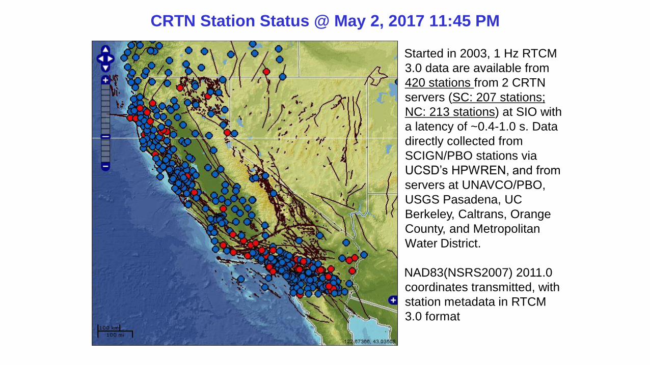
CRTN Station Status @ May 2, 2017 11:45 PM
Started in 2003, 1 Hz RTCM
3.0 data are available from
420 stations from 2 CRTN
servers (SC: 207 stations;
NC: 213 stations) at SIO with
a latency of ~0.4-1.0 s. Data
directly collected from
SCIGN/PBO stations via
UCSD’s HPWREN, and from
servers at UNAVCO/PBO,
USGS Pasadena, UC
Berkeley, Caltrans, Orange
County, and Metropolitan
Water District.
NAD83(NSRS2007) 2011.0
coordinates transmitted, with
station metadata in RTCM
3.0 format
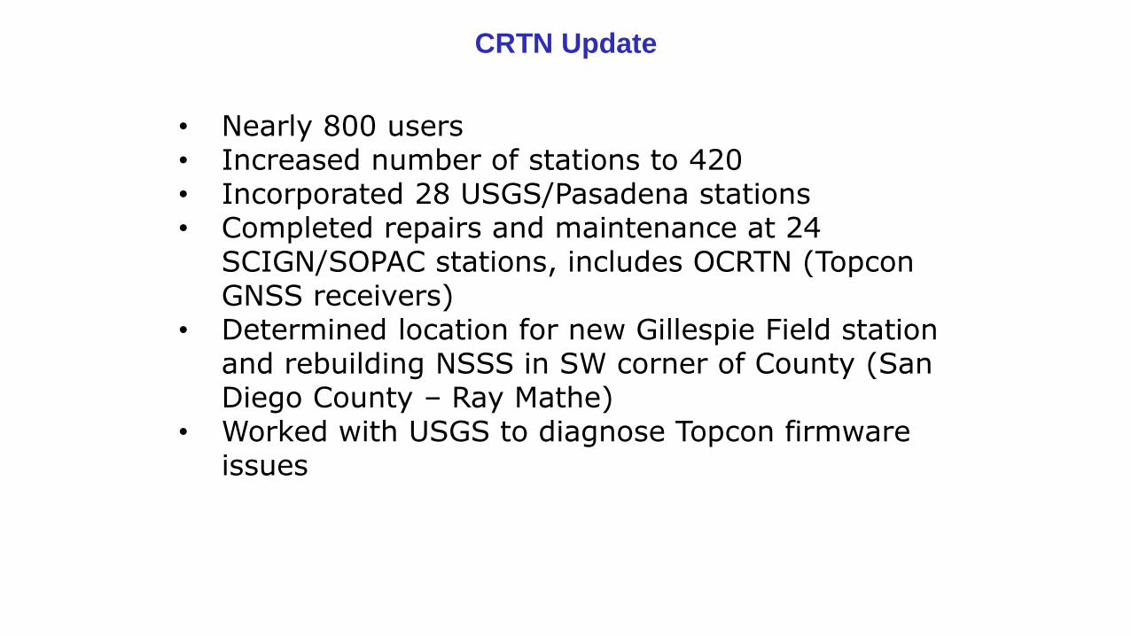
CRTN Update
• Nearly 800 users• Increased number of stations to 420• Incorporated 28 USGS/Pasadena stations• Completed repairs and maintenance at 24
SCIGN/SOPAC stations, includes OCRTN (Topcon GNSS receivers)
• Determined location for new Gillespie Field station and rebuilding NSSS in SW corner of County (San Diego County – Ray Mathe)
• Worked with USGS to diagnose Topcon firmware issues
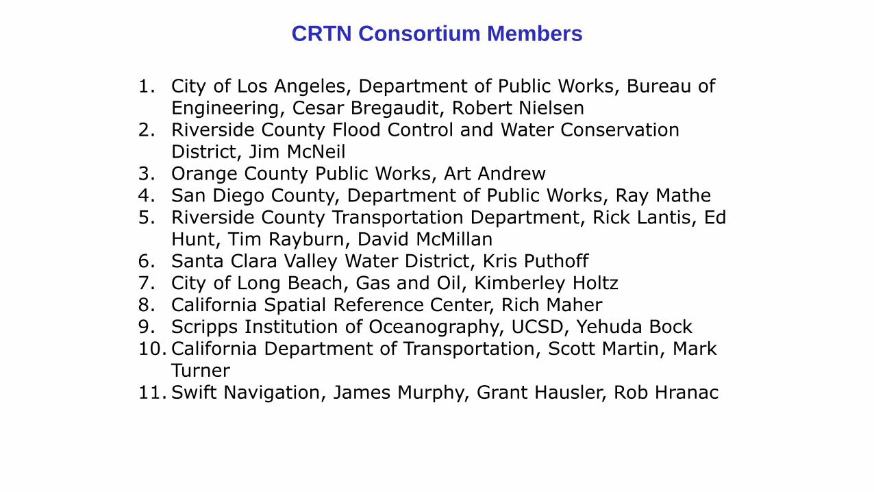
CRTN Consortium Members
1. City of Los Angeles, Department of Public Works, Bureau of Engineering, Cesar Bregaudit, Robert Nielsen
2. Riverside County Flood Control and Water Conservation District, Jim McNeil
3. Orange County Public Works, Art Andrew4. San Diego County, Department of Public Works, Ray Mathe5. Riverside County Transportation Department, Rick Lantis, Ed
Hunt, Tim Rayburn, David McMillan6. Santa Clara Valley Water District, Kris Puthoff 7. City of Long Beach, Gas and Oil, Kimberley Holtz8. California Spatial Reference Center, Rich Maher9. Scripps Institution of Oceanography, UCSD, Yehuda Bock10. California Department of Transportation, Scott Martin, Mark
Turner11. Swift Navigation, James Murphy, Grant Hausler, Rob Hranac
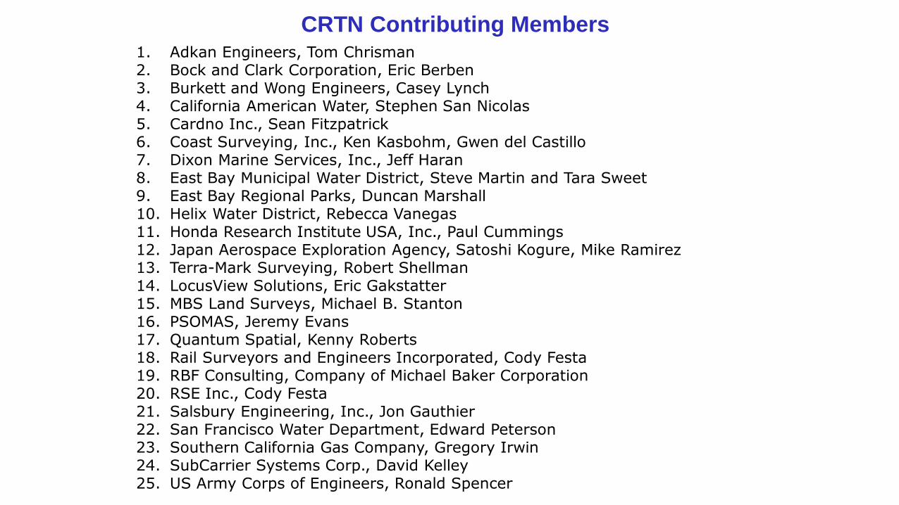
CRTN Contributing Members1. Adkan Engineers, Tom Chrisman2. Bock and Clark Corporation, Eric Berben3. Burkett and Wong Engineers, Casey Lynch4. California American Water, Stephen San Nicolas5. Cardno Inc., Sean Fitzpatrick6. Coast Surveying, Inc., Ken Kasbohm, Gwen del Castillo7. Dixon Marine Services, Inc., Jeff Haran8. East Bay Municipal Water District, Steve Martin and Tara Sweet9. East Bay Regional Parks, Duncan Marshall10. Helix Water District, Rebecca Vanegas11. Honda Research Institute USA, Inc., Paul Cummings12. Japan Aerospace Exploration Agency, Satoshi Kogure, Mike Ramirez13. Terra-Mark Surveying, Robert Shellman14. LocusView Solutions, Eric Gakstatter15. MBS Land Surveys, Michael B. Stanton16. PSOMAS, Jeremy Evans17. Quantum Spatial, Kenny Roberts18. Rail Surveyors and Engineers Incorporated, Cody Festa19. RBF Consulting, Company of Michael Baker Corporation20. RSE Inc., Cody Festa21. Salsbury Engineering, Inc., Jon Gauthier22. San Francisco Water Department, Edward Peterson23. Southern California Gas Company, Gregory Irwin24. SubCarrier Systems Corp., David Kelley25. US Army Corps of Engineers, Ronald Spencer
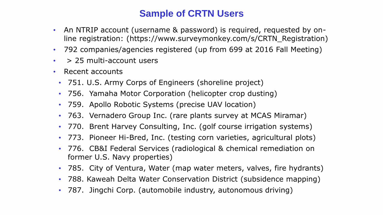
Sample of CRTN Users
• An NTRIP account (username & password) is required, requested by on-line registration: (https://www.surveymonkey.com/s/CRTN_Registration)
• 792 companies/agencies registered (up from 699 at 2016 Fall Meeting)
• > 25 multi-account users
• Recent accounts
• 751. U.S. Army Corps of Engineers (shoreline project)
• 756. Yamaha Motor Corporation (helicopter crop dusting)
• 759. Apollo Robotic Systems (precise UAV location)
• 763. Vernadero Group Inc. (rare plants survey at MCAS Miramar)
• 770. Brent Harvey Consulting, Inc. (golf course irrigation systems)
• 773. Pioneer Hi-Bred, Inc. (testing corn varieties, agricultural plots)
• 776. CB&I Federal Services (radiological & chemical remediation on former U.S. Navy properties)
• 785. City of Ventura, Water (map water meters, valves, fire hydrants)
• 788. Kaweah Delta Water Conservation District (subsidence mapping)
• 787. Jingchi Corp. (automobile industry, autonomous driving)
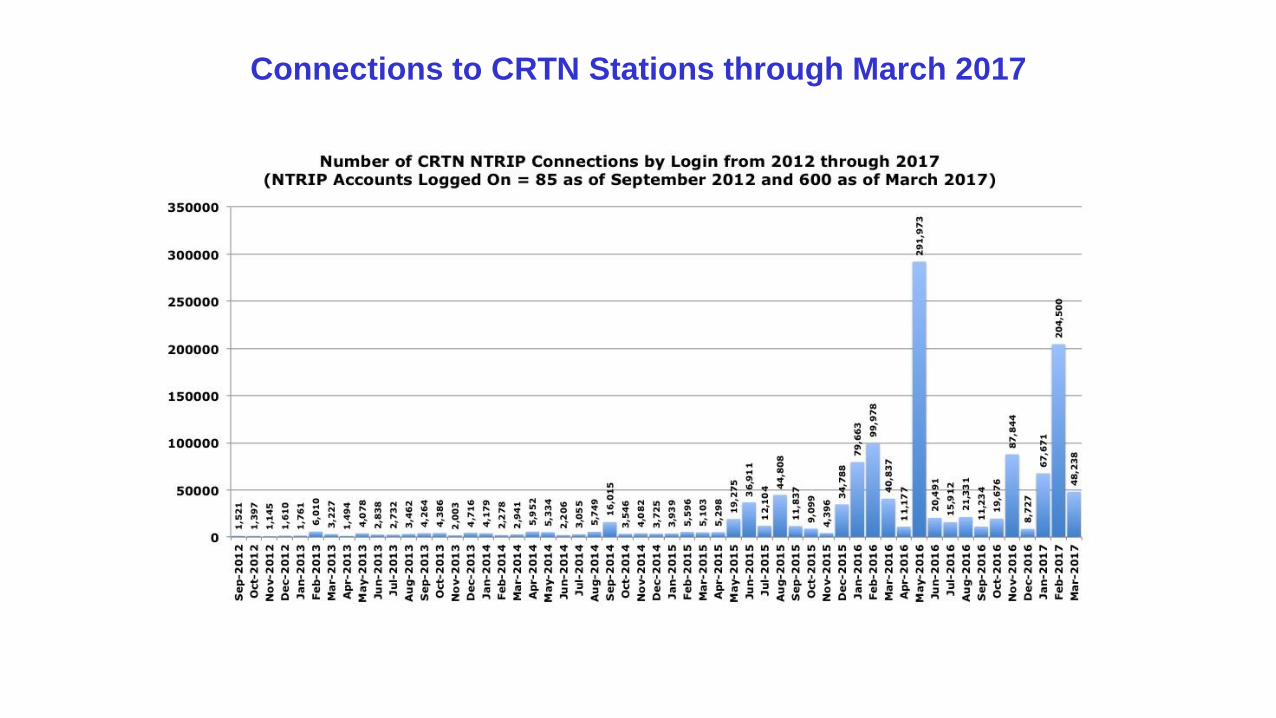
Connections to CRTN Stations through March 2017
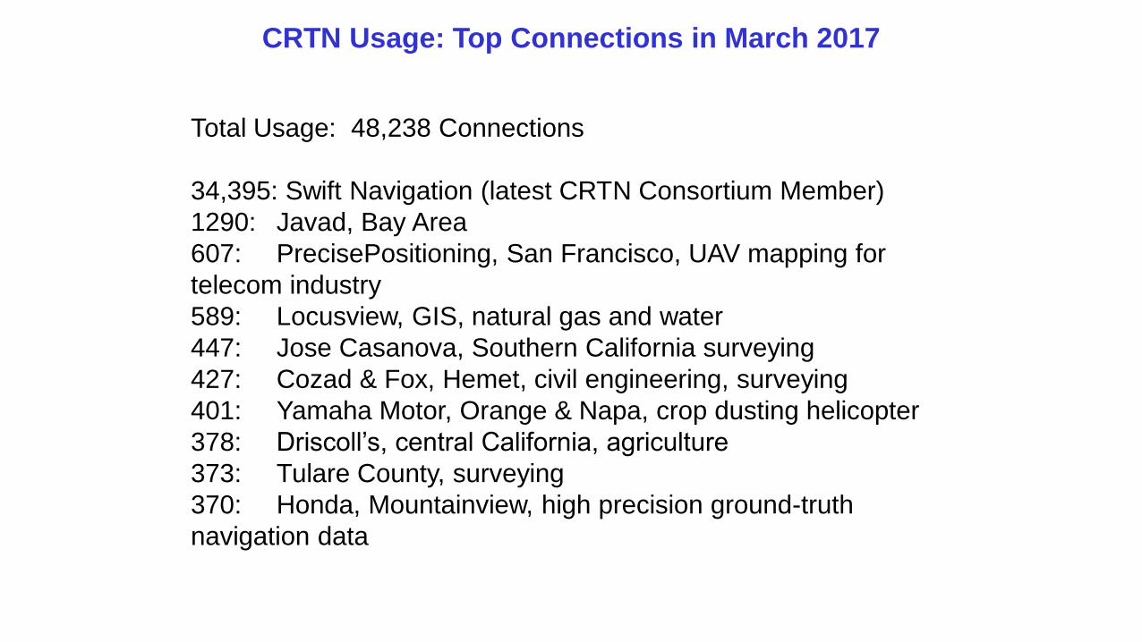
CRTN Usage: Top Connections in March 2017
Total Usage: 48,238 Connections
34,395: Swift Navigation (latest CRTN Consortium Member)
1290: Javad, Bay Area
607: PrecisePositioning, San Francisco, UAV mapping for
telecom industry
589: Locusview, GIS, natural gas and water
447: Jose Casanova, Southern California surveying
427: Cozad & Fox, Hemet, civil engineering, surveying
401: Yamaha Motor, Orange & Napa, crop dusting helicopter
378: Driscoll’s, central California, agriculture
373: Tulare County, surveying
370: Honda, Mountainview, high precision ground-truth
navigation data
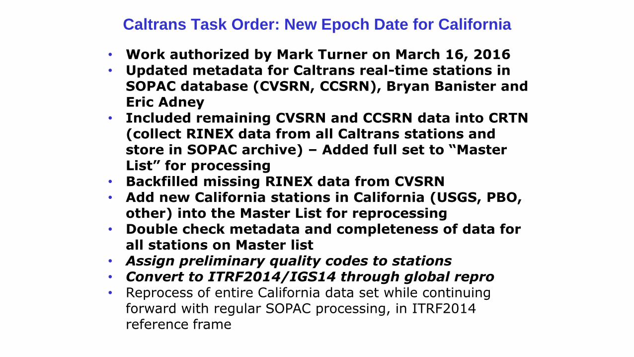
• Work authorized by Mark Turner on March 16, 2016• Updated metadata for Caltrans real-time stations in
SOPAC database (CVSRN, CCSRN), Bryan Banister and Eric Adney
• Included remaining CVSRN and CCSRN data into CRTN (collect RINEX data from all Caltrans stations and store in SOPAC archive) – Added full set to “Master List” for processing
• Backfilled missing RINEX data from CVSRN• Add new California stations in California (USGS, PBO,
other) into the Master List for reprocessing• Double check metadata and completeness of data for
all stations on Master list• Assign preliminary quality codes to stations• Convert to ITRF2014/IGS14 through global repro• Reprocess of entire California data set while continuing
forward with regular SOPAC processing, in ITRF2014 reference frame
Caltrans Task Order: New Epoch Date for California
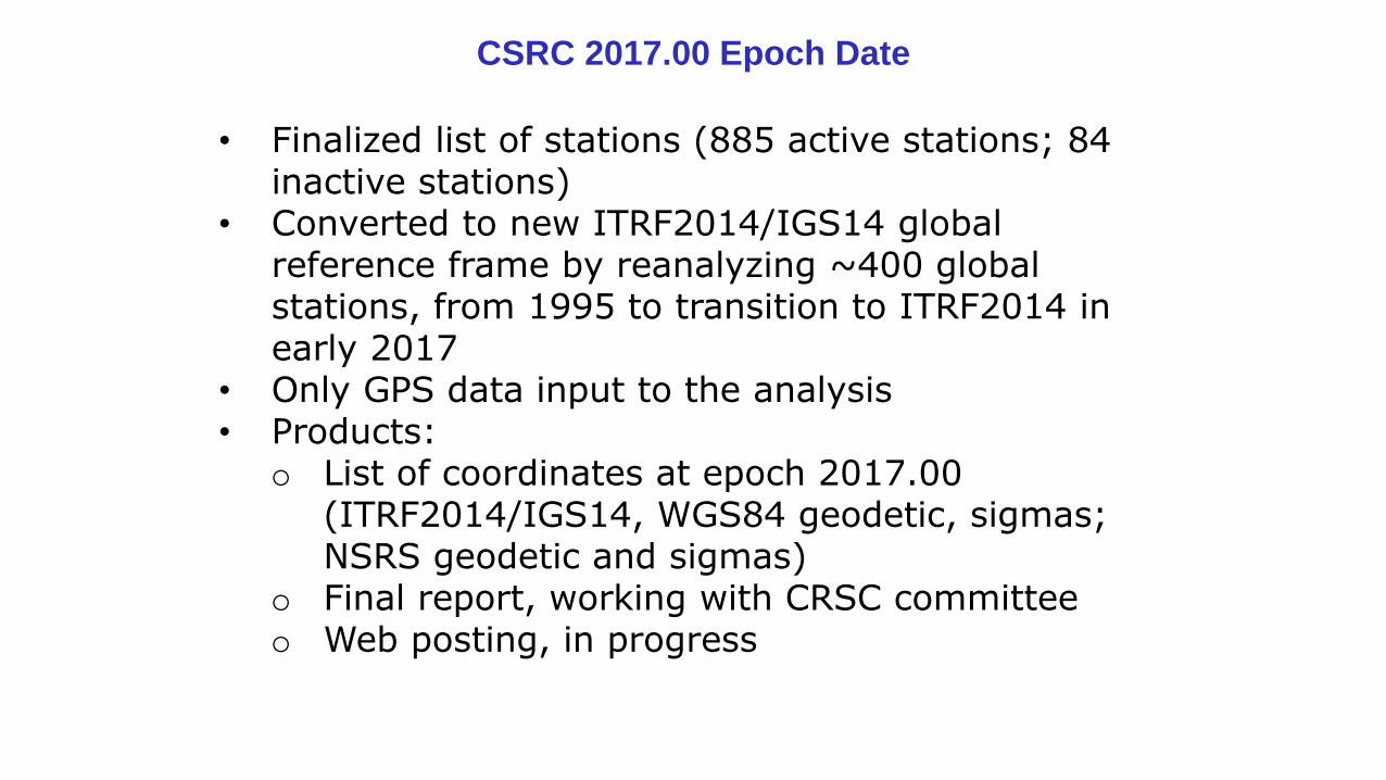
CSRC 2017.00 Epoch Date
• Finalized list of stations (885 active stations; 84 inactive stations)
• Converted to new ITRF2014/IGS14 global reference frame by reanalyzing ~400 global stations, from 1995 to transition to ITRF2014 in early 2017
• Only GPS data input to the analysis• Products:
o List of coordinates at epoch 2017.00 (ITRF2014/IGS14, WGS84 geodetic, sigmas; NSRS geodetic and sigmas)
o Final report, working with CRSC committeeo Web posting, in progress
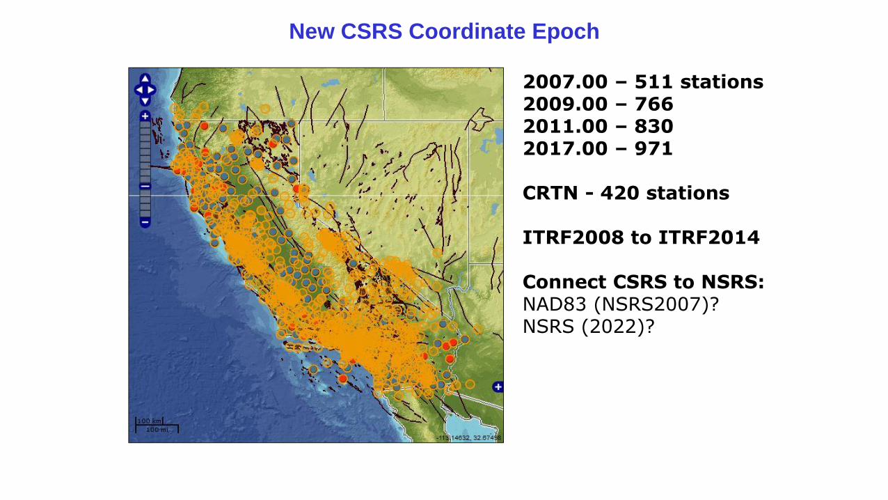
New CSRS Coordinate Epoch
2007.00 – 511 stations2009.00 – 766 2011.00 – 830 2017.00 – 971
CRTN - 420 stations
ITRF2008 to ITRF2014
Connect CSRS to NSRS:NAD83 (NSRS2007)?NSRS (2022)?
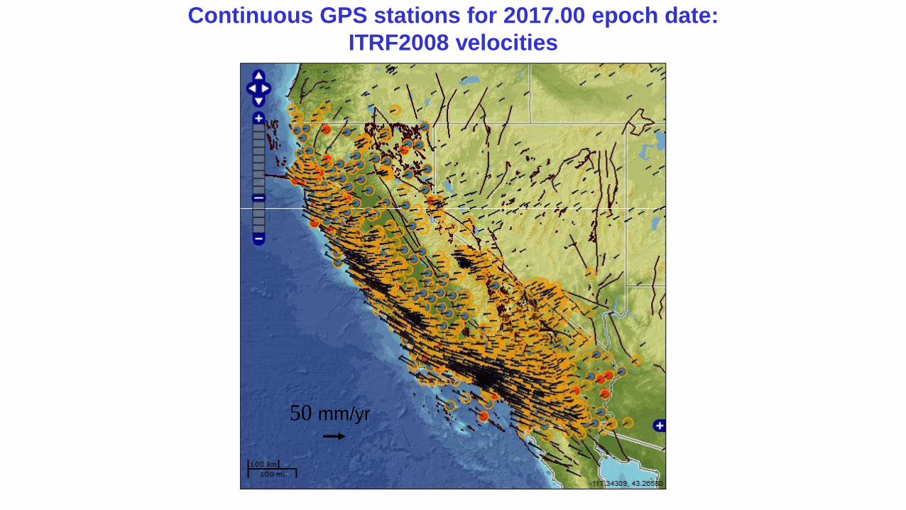
Continuous GPS stations for 2017.00 epoch date:
ITRF2008 velocities
50 mm/yr
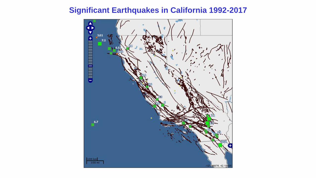
Significant Earthquakes in California 1992-2017
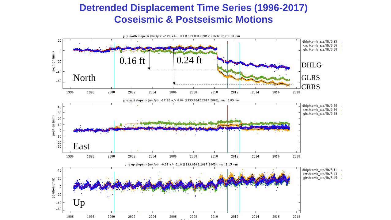
Detrended Displacement Time Series (1996-2017)
Coseismic & Postseismic Motions
CRRS
DHLG
GLRS
East
Up
North
0.24 ft0.16 ft
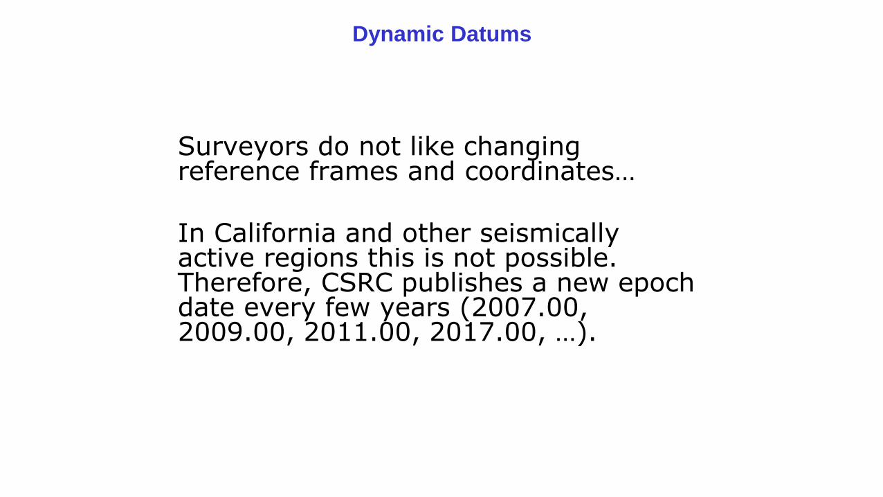
Surveyors do not like changing reference frames and coordinates…
In California and other seismically active regions this is not possible. Therefore, CSRC publishes a new epoch date every few years (2007.00, 2009.00, 2011.00, 2017.00, …).
Dynamic Datums
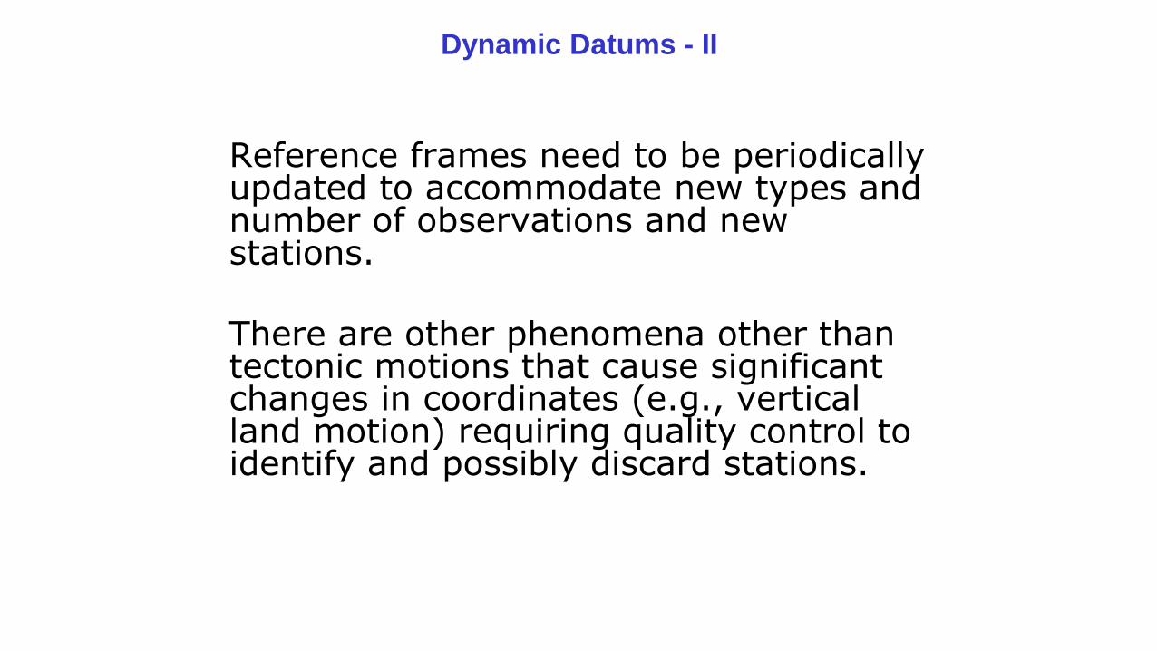
Dynamic Datums - II
Reference frames need to be periodically updated to accommodate new types and number of observations and new stations.
There are other phenomena other than tectonic motions that cause significant changes in coordinates (e.g., vertical land motion) requiring quality control to identify and possibly discard stations.
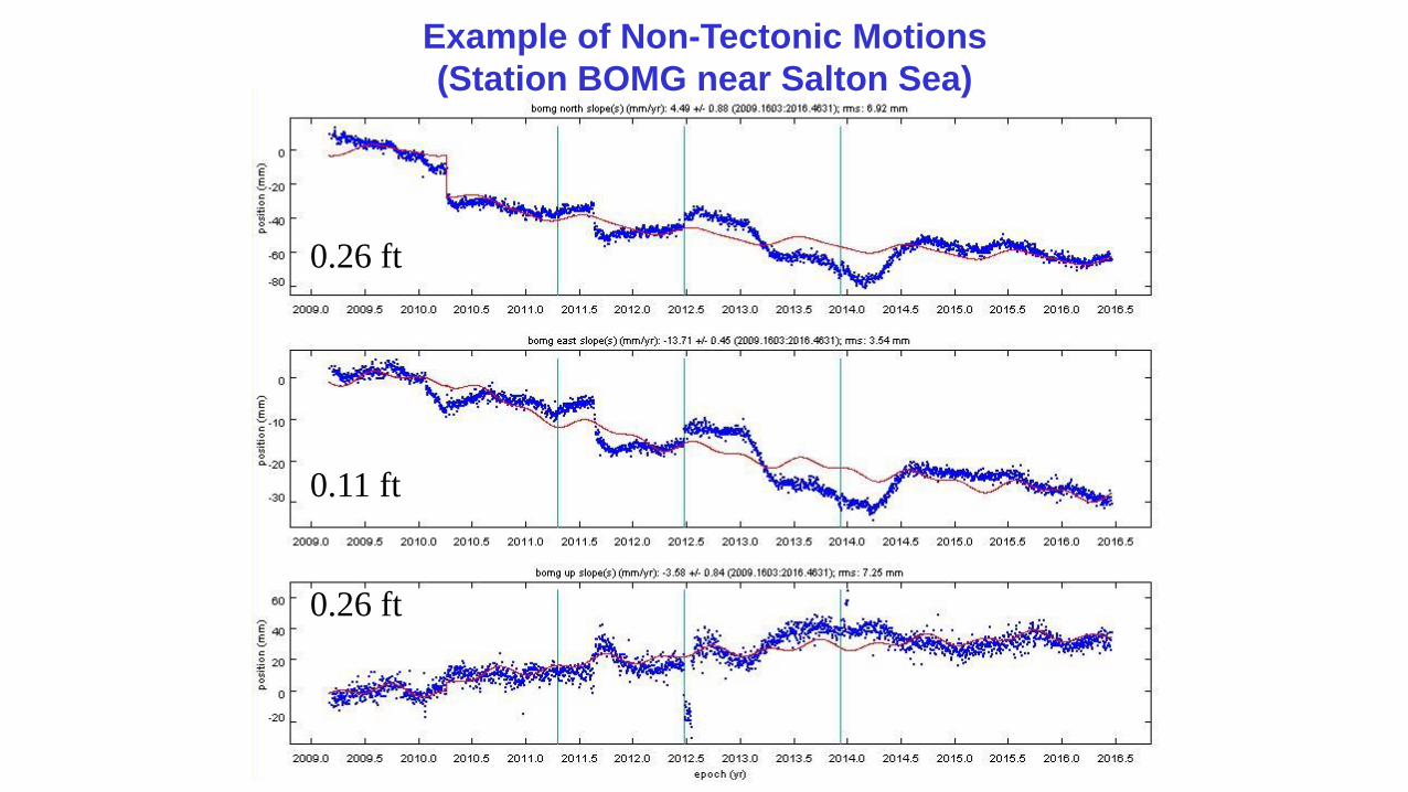
Example of Non-Tectonic Motions
(Station BOMG near Salton Sea)
0.26 ft
0.26 ft
0.11 ft
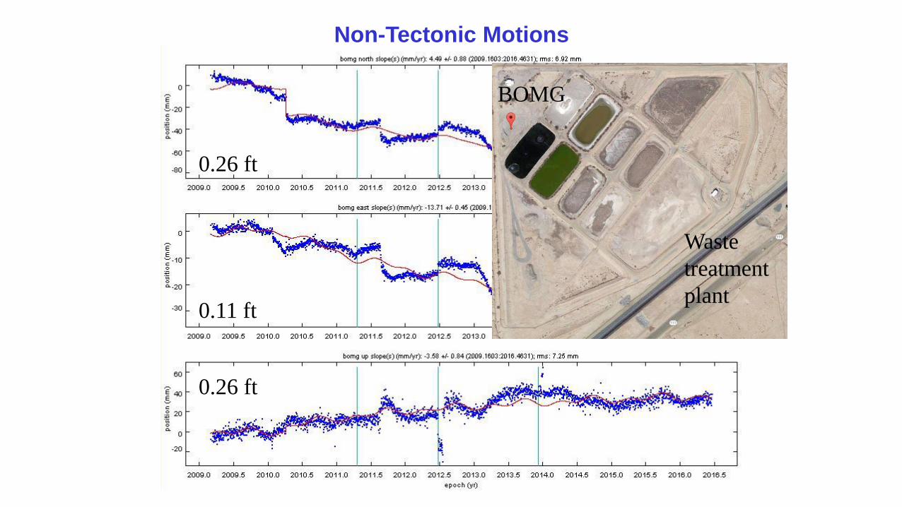
BOMG
Waste
treatment
plant
Non-Tectonic Motions
0.26 ft
0.26 ft
0.11 ft
Dynamic Datums - III
Creating a new epoch date for coordinates with an increase in number of stations modifies the reference system, realized through the epoch-date coordinates of the permanent GNSS stations. So does the change from, say, ITRF2008 to ITRF2014
You can think of the reference frame as a triangulated network in 2-D (or a polyhedron in 3-D) whose shape and size changes in time. The epoch-date coordinates are a snapshot at a particular epoch of time with respect to a global reference frame (ITRF2014/IGS14)
Dynamic Datums - IV
The reference frame is defined by the positions of the permanent GNSS at a particular epoch of time (now CSRC Epoch 2011.00), and you can update CSRS station coordinates to any other epoch through, for example, SOPAC’s SECTOR application.
However, estimating the true-of-date coordinates of a new surveyed station with respect to the reference frame requires an additional step.
There are at least two approaches: interpolation or crustal deformation model
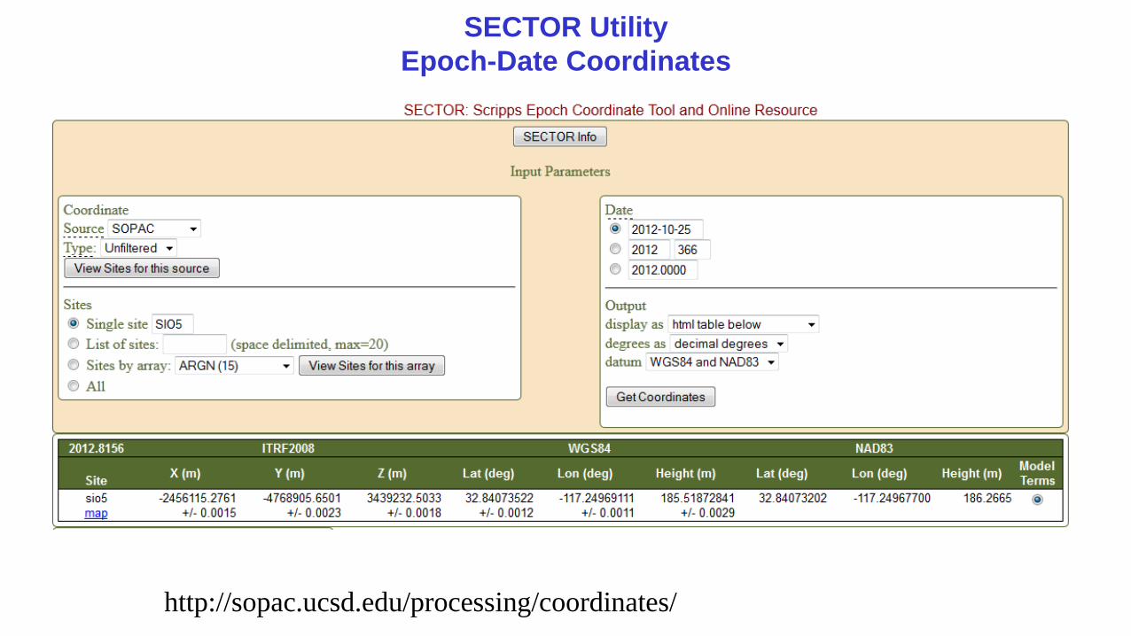
SECTOR Utility
Epoch-Date Coordinates
http://sopac.ucsd.edu/processing/coordinates/
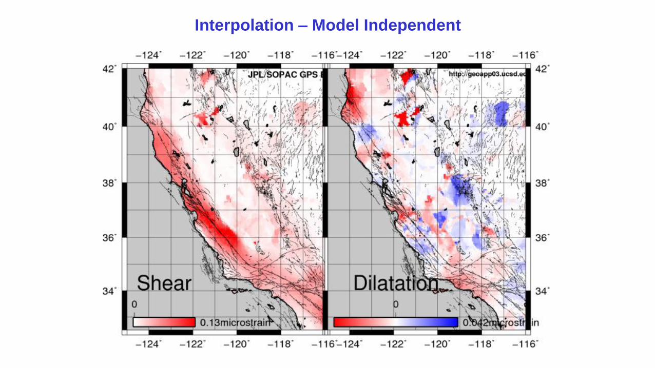
Interpolation – Model Independent
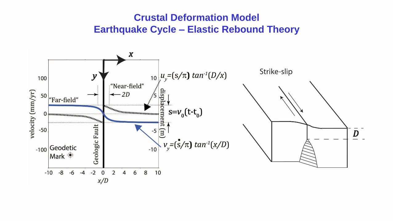
Crustal Deformation Model
Earthquake Cycle – Elastic Rebound Theory
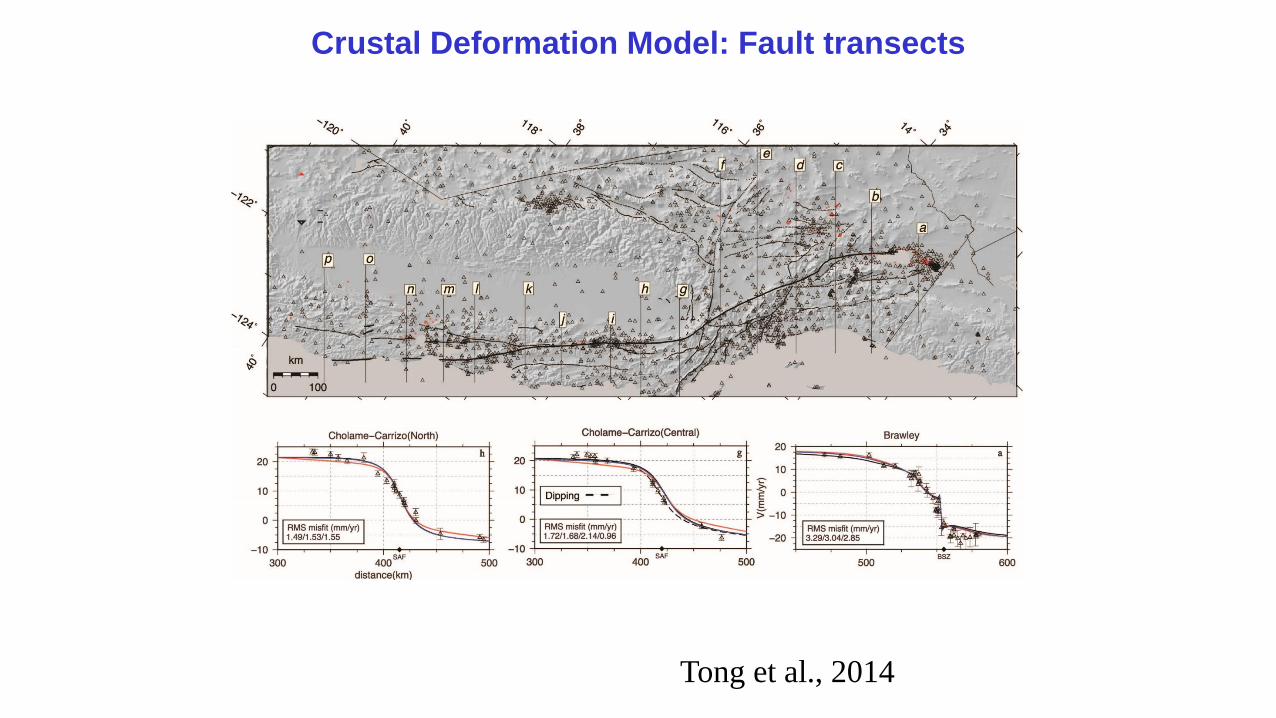
Crustal Deformation Model: Fault transects
Tong et al., 2014
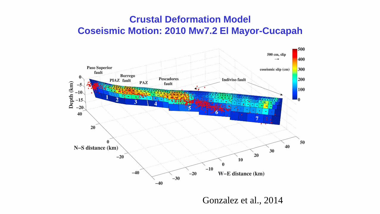
Crustal Deformation Model
Coseismic Motion: 2010 Mw7.2 El Mayor-Cucapah
Gonzalez et al., 2014
Dynamic Datums - V
• A GNSS survey (say RTK) is conducted at some date and positioned wrt the CSRS (say, in real time using CRTN). The surveyor receives the metadata for the reference station(s) and true-of-date ITRF coordinates as part of the RTCM3 message, consistent with the IGS frame and orbits, and estimates coordinates of surveyed marks with his/her usual field device. The true-of-date coordinates of the CRTN stations are derived using a SECTOR-type app.
• The surveyor can refer back to an earlier epoch date using an up-to-date HTDP-type model, which is consistent with the CSRS, since the model was derived from the CSRN coordinate time series.
• Whether at the survey date or an earlier date, the ITRF positions can then be converted to geodetic coordinates (say with respect to the NSRS) and then to map coordinates, if required.
• Is implementation and acceptance of a dynamic datum made any easier now that maps are digital, or after paper maps have been digitized?
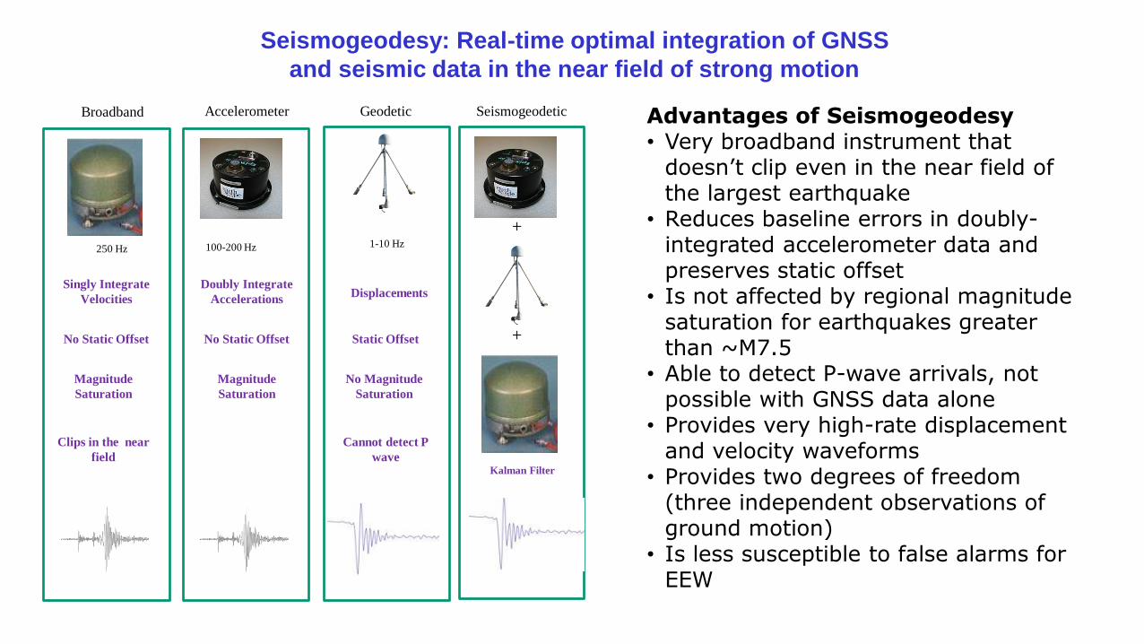
Advantages of Seismogeodesy• Very broadband instrument that
doesn’t clip even in the near field of the largest earthquake
• Reduces baseline errors in doubly-integrated accelerometer data and preserves static offset
• Is not affected by regional magnitude saturation for earthquakes greater than ~M7.5
• Able to detect P-wave arrivals, not possible with GNSS data alone
• Provides very high-rate displacement and velocity waveforms
• Provides two degrees of freedom (three independent observations of ground motion)
• Is less susceptible to false alarms for EEW
Seismogeodesy: Real-time optimal integration of GNSS
and seismic data in the near field of strong motion
1-10 Hz100-200 Hz
DisplacementsDoubly Integrate
Accelerations
Kalman Filter
Accelerometer Geodetic Seismogeodetic
250 Hz
Singly Integrate
Velocities
+
+
Clips in the near
field
No Static Offset No Static Offset Static Offset
Broadband
Magnitude
Saturation
Magnitude
Saturation
Cannot detect P
wave
No Magnitude
Saturation
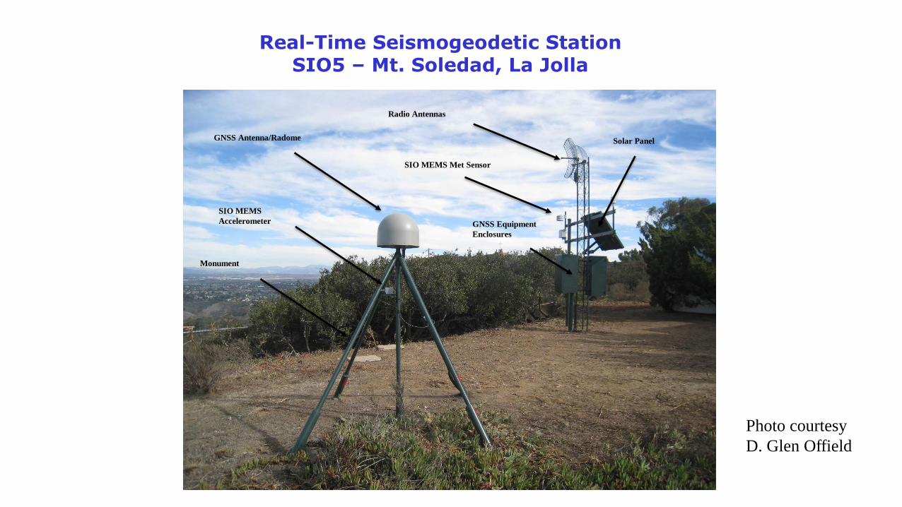
Real-Time Seismogeodetic Station SIO5 – Mt. Soledad, La Jolla
GNSS Antenna/Radome
Monument
SIO MEMS
Accelerometer
Radio Antennas
Solar Panel
SIO MEMS Met Sensor
GNSS Equipment
Enclosures
Photo courtesy
D. Glen Offield
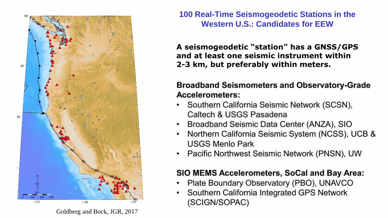
100 Real-Time Seismogeodetic Stations in the
Western U.S.: Candidates for EEW
A seismogeodetic “station” has a GNSS/GPS and at least one seismic instrument within 2-3 km, but preferably within meters.
Goldberg and Bock, JGR, 2017
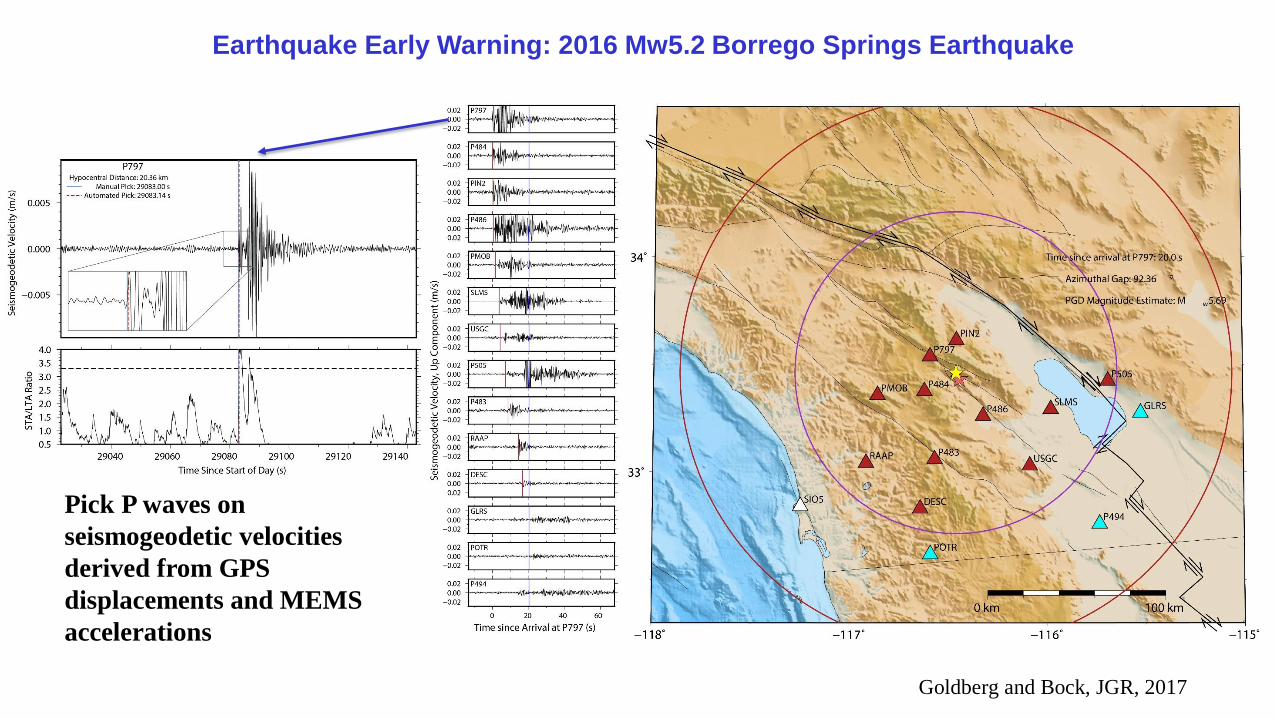
Earthquake Early Warning: 2016 Mw5.2 Borrego Springs Earthquake
Goldberg and Bock, JGR, 2017
Pick P waves on
seismogeodetic velocities
derived from GPS
displacements and MEMS
accelerations
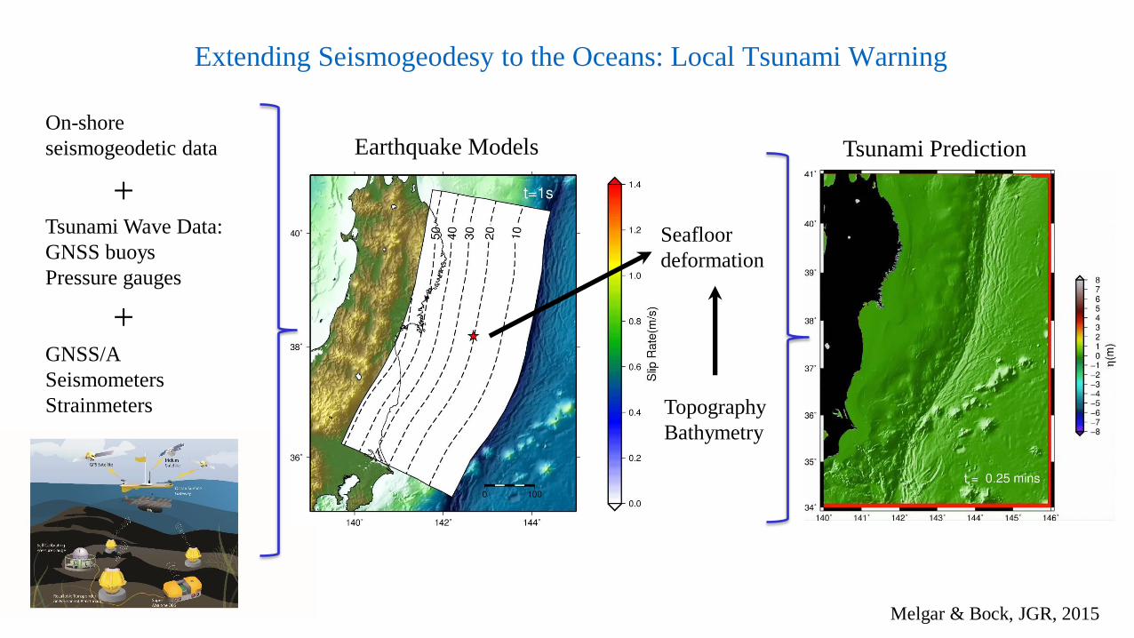
Extending Seismogeodesy to the Oceans: Local Tsunami Warning
Melgar & Bock, JGR, 2015
On-shore
seismogeodetic data
Tsunami Wave Data:
GNSS buoys
Pressure gauges
GNSS/A
Seismometers
Strainmeters
Seafloor
deformation
Earthquake Models
Topography
Bathymetry
Tsunami Prediction
+
+
Satellite
Orbits
&
Clocks
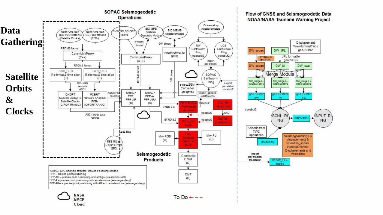
Data
Gathering
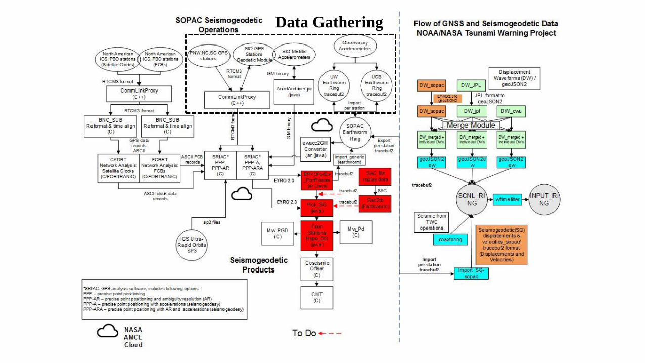
Data Gathering
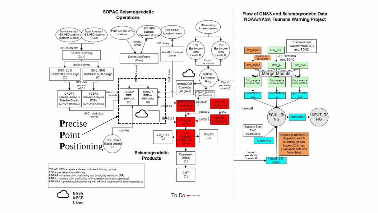
Precise
Point
Positioning
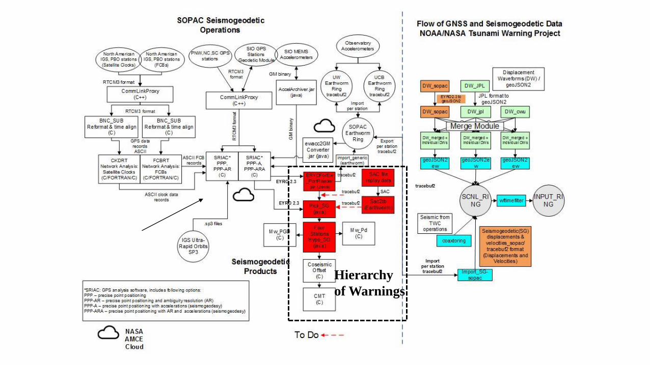
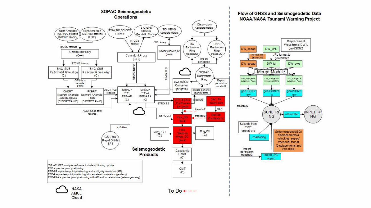
Hierarchy
of Warnings
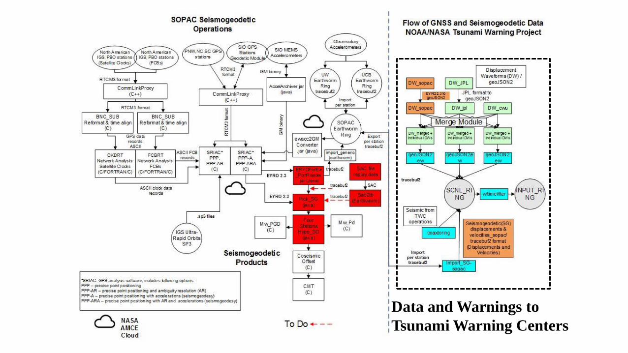
Data and Warnings to
Tsunami Warning Centers
Director’s Report:
CRTN, Epoch Update & Dynamic Datum
Questions?