Embed Size (px)
Citation preview
El Garouani A. and Alobeid A.
1 Eighth National GIS Symposium in Saudi Arabia – April 15-17, 2013, Dammam
Digital Surface Model generation for 3D City Modeling (Fez, Morocco)
Dr. Abdelkader El Garouani
Faculty of Sciences and Techiques, Sidi Mohamed Ben Abdellah University, Fez, Morocco. Mobile: 212663829046 [email protected]
Dr.-Ing. Abdalla Alobeid
Institute of Photogrammetry and GeoInformation, Leibniz University, Hannover, Germany Tel: +4951176217310
Abstract:
The Historic Medina of Fez is one of the most important tourism locations in Morocco and is a challenge for 3D city modeling due to its complex building and roads structure. Due to its importance this Historic Medina of Fez was added to the UNESCO World Heritage List in 1981. It is located on the northern part of Morocco. Several disciplines like urban planning, architecture, telecommunication, tourism, environmental protection and many others have an increasing demand for digital 3D city models, in order to use such complex data for planning, analyses, visualization and simulation in different applications. Additionally, the open geospatial viewers (e.g. Google Earth, Virtual Earth, etc.) increase the demand on 3D city models. 3D city model and its update require the development of automatic methods for acquisition of Digital Surface Models (DSM). In this work, we discuss the construction of a digital surface model based on aerial image stereo pairs using matching method and the use of this DSM for 3D city planning. We used aerial photographs with high accuracy (1/4000) covering the study area acquired in 2007 and additional cartographic data from Fez. To process these data we used LPS of Erdas Imagine 9.3 and ArcGIS 10. 3D models can be used as a user-friendly interface for querying the urban environment as a Geographic Information Systems (GIS), for hyper-linking Web-based information, for visualizing model results, and for accessing functional simulation models. Key-word: 3D City Model, DSM, Historic city planning, Fez, Morocco
I- INTRODUCTION
3D city models are digital representations of the Earth’s surface and related objects belonging to urban areas (like cities, factories, buildings etc.). Several disciplines like urban planning, architecture, telecommunication, tourism, environmental protection and many others have an increasing demand for digital 3D city models, in order to use such complex data for planning, analyses, visualization and simulation in different applications. Additionally, the open geospatial viewers (e.g. Google Earth, Virtual Earth, etc.) increase the demand on 3D city models (Remondino et al., 2006). 3D city model and its update require the development of automatic methods for
El Garouani A. and Alobeid A.
2 Eighth National GIS Symposium in Saudi Arabia – April 15-17, 2013, Dammam
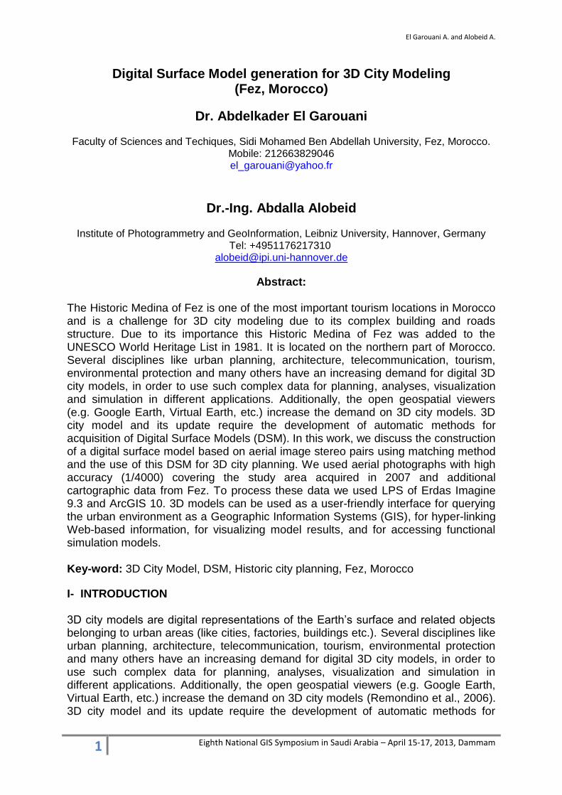
acquisition of Digital Surface Models (DSM) (Toutin and Gray, 2000). Digital photogrammetry, both airborne and spatial, is efficient modern technique for DSM acquisition as a base for 3D city modelling. A digital surface model represents the elevation associated with the surface of the earth including topography and all natural or human-made features located on the surface of the earth. There is a variety of DSM source data available for developed areas and the suitability of this available data is depending on the project specifications. In remote regions around the World, were little or no source data is available, the DSM can be produced automatically from stereo satellite scenes, from satellite sensors such as IKONOS, SPOT-5 and Terra-ASTER (Alobeid, et al., 2010; Jacobsen, 2004). The DSM can also be provided from stereo digital aerial photography at various resolutions, depending on the quality and scale of the aerial photography. This study concerns the historic city of Fez which is one of the most important tourism locations in Morocco and is a challenge for 3D city modelling due to its complex building and roads structure. Due to its importance this historic Medina of Fez was added to the UNESCO World Heritage List in 1981. It is located on the northern part of Morocco (Fig. 1).
Figure 1: Location of the study area
In this work, we discuss the construction of a digital surface model based on aerial image stereo pairs using matching method and the use of this DSM for 3D city planning. II- MATERIAL AND METHOD
2.1. Study region
Africa
Morocco
Mali
Algeria
Mauritania
Fez
El Garouani A. and Alobeid A.
3 Eighth National GIS Symposium in Saudi Arabia – April 15-17, 2013, Dammam
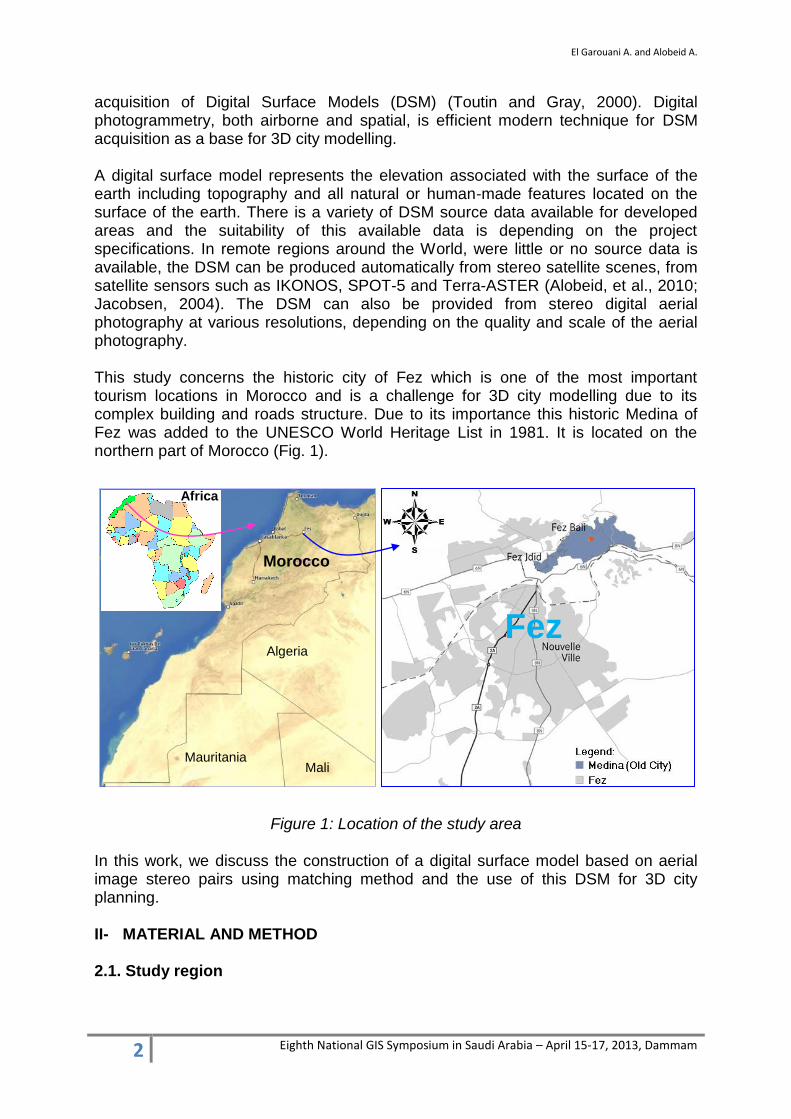
Fez is the most ancient of the imperial cities of Morocco. The urban community of Fez accounts for one million inhabitants and the city has about 30 km² (El Garouani et al., 2011). Founded in 789 by Moulay Idriss 1st and home to the oldest university in the world (Quaraouiyyîn university built in 857), Fez reached its height in the 13th–14th centuries under the Marinids, when it replaced Marrakesh as the capital of the kingdom. The urban fabric and the principal monuments in the medina – madrasas (traditional school), fondouks (traditional hotels), palaces, residences, mosques and fountains - date from this period (EL Garouani et al., 2012). Although the political capital of Morocco was transferred to Rabat in 1912, Fez has retained its status as the country's cultural and spiritual center. Fez is a religious, touristic and academic center. The figure bellow presents some historic landscapes of Fez Medina.
Figure 2: Royal Palace (in the left), Univesity Quaraouiyne (in the right) The 3D city model of Fez can be used for many applications:
visualize the city for various purposes (tourism, virtual tours, etc.),
urban planning,
navigation systems,
intelligent transportation systems,
urban risk modelling;
architectural visualization;
telecoms – positioning of mobile phone transmitters;
flood risk mapping.
2.2. DSM generation method This work investigates the topic of automatic image matching with focus on the generation of DSMs using imagery acquired from airborne or space sensors. There is a variety of algorithms that have been developed for DSM generating from satellite images and aerial photography (Büyüksalih and Jacobsen, 2007). One of the methods is to use two images at a time for the reconstruction of a three dimensional stereo model in which the altimetric information can be extracted (Toutin, 1995). This method generally contains three basic steps: set up sensor mathematical model to reflect the relationship between points on the ground and pixels on the image, do image matching to get a disparity map, and finally calculate each point’s altitude. In

El Garouani A. and Alobeid A.
4 Eighth National GIS Symposium in Saudi Arabia – April 15-17, 2013, Dammam
this study, we can use the procedure of DSM generation developed by Kwoh et al. (2004). This process can be broken down into the following steps: Figure 3 shows the main work flows of the research work. The work flow is mainly designed to develop a DSM which will take aerial image stereo pairs data and other additional information as input and will produce desired surface model as output (El Garouani, 2009).
Figure 3: Working process of DSM generation Step 1 - Ground Point Coordinate Determination The point measurement tool is designed to collect Ground Control Points (GCPs) and tie points that are common to two images so that the images can be correlated. In the case of IKONOS imagery, the RPC file that comes with the images contains valuable information that lessens the need to collect large numbers of control points. In this step we can see how choosing GCPs and generating automatic tie points can considerably improve the results of the orthorectification (Rottensteiner et al. 2008). Step 2 - Digital Image Matching for DSM Ground points appearing within the overlap portion of the left and right images associated with a DSM are identified. This is referred to as digital image matching. The resulting output consists of the image location of ground points appearing within a DSM. Step 3 - DSM Construction
Aerial image Stereo pairs
Generate image pyramid
Contrast
enhancement Tie points or
GCPs
Define sensor
model
Gradient magnitude
images
Hierarchical image matching
to generate DSM
El Garouani A. and Alobeid A.
5 Eighth National GIS Symposium in Saudi Arabia – April 15-17, 2013, Dammam
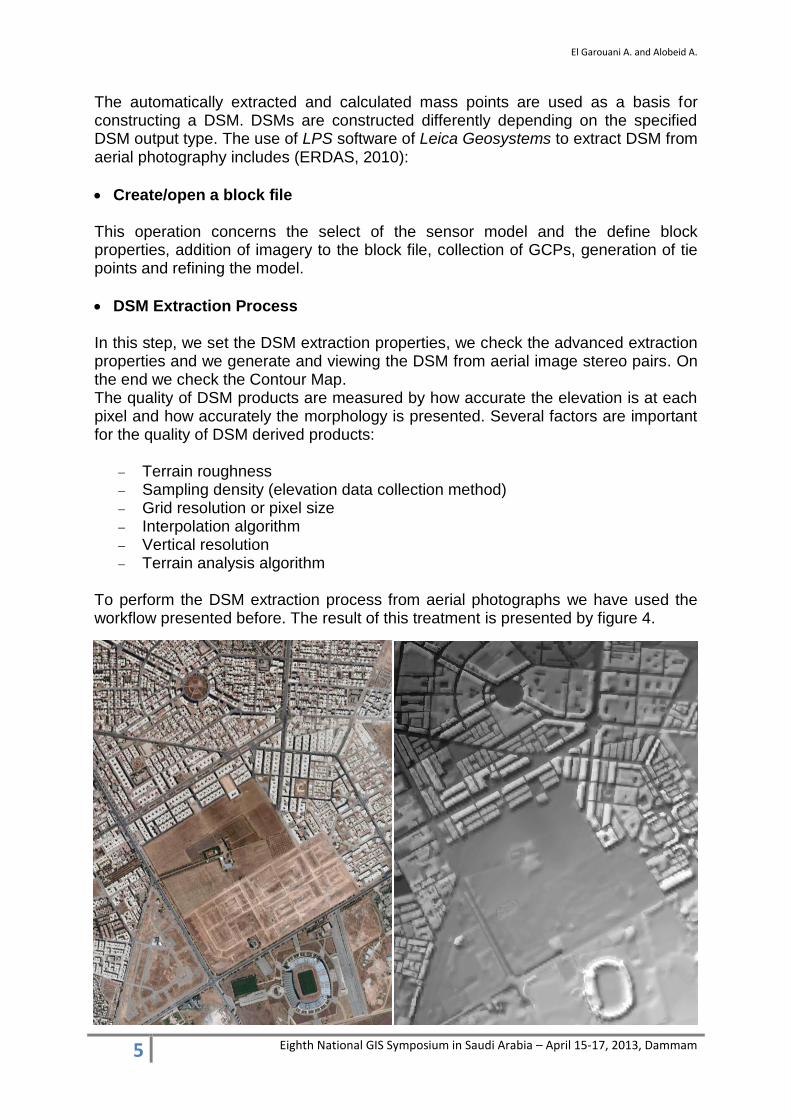
The automatically extracted and calculated mass points are used as a basis for constructing a DSM. DSMs are constructed differently depending on the specified DSM output type. The use of LPS software of Leica Geosystems to extract DSM from aerial photography includes (ERDAS, 2010):
Create/open a block file This operation concerns the select of the sensor model and the define block properties, addition of imagery to the block file, collection of GCPs, generation of tie points and refining the model.
DSM Extraction Process In this step, we set the DSM extraction properties, we check the advanced extraction properties and we generate and viewing the DSM from aerial image stereo pairs. On the end we check the Contour Map. The quality of DSM products are measured by how accurate the elevation is at each pixel and how accurately the morphology is presented. Several factors are important for the quality of DSM derived products:
Terrain roughness Sampling density (elevation data collection method) Grid resolution or pixel size Interpolation algorithm Vertical resolution Terrain analysis algorithm
To perform the DSM extraction process from aerial photographs we have used the workflow presented before. The result of this treatment is presented by figure 4.
El Garouani A. and Alobeid A.
6 Eighth National GIS Symposium in Saudi Arabia – April 15-17, 2013, Dammam
Figure 4: DSM generated from aerial photographs
III. RESULTS AND DISCUSSION
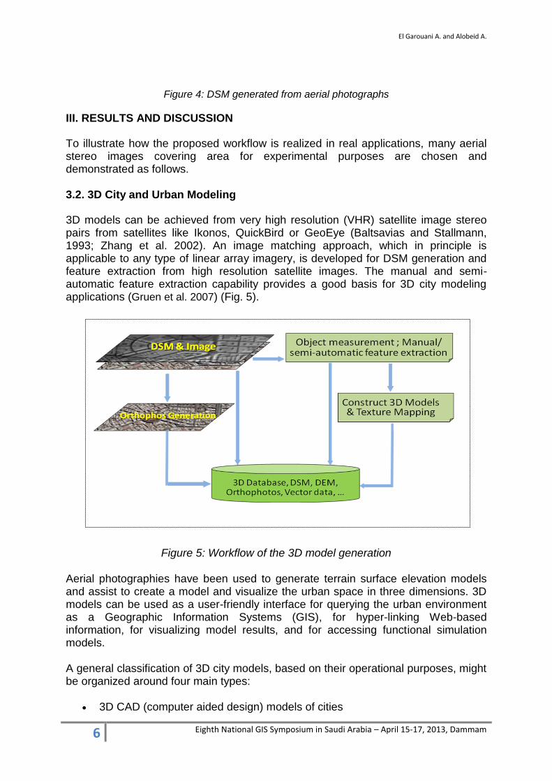
To illustrate how the proposed workflow is realized in real applications, many aerial stereo images covering area for experimental purposes are chosen and demonstrated as follows. 3.2. 3D City and Urban Modeling
3D models can be achieved from very high resolution (VHR) satellite image stereo pairs from satellites like Ikonos, QuickBird or GeoEye (Baltsavias and Stallmann, 1993; Zhang et al. 2002). An image matching approach, which in principle is applicable to any type of linear array imagery, is developed for DSM generation and feature extraction from high resolution satellite images. The manual and semi-automatic feature extraction capability provides a good basis for 3D city modeling applications (Gruen et al. 2007) (Fig. 5).
Figure 5: Workflow of the 3D model generation
Aerial photographies have been used to generate terrain surface elevation models and assist to create a model and visualize the urban space in three dimensions. 3D models can be used as a user-friendly interface for querying the urban environment as a Geographic Information Systems (GIS), for hyper-linking Web-based information, for visualizing model results, and for accessing functional simulation models. A general classification of 3D city models, based on their operational purposes, might be organized around four main types:
3D CAD (computer aided design) models of cities
El Garouani A. and Alobeid A.
7 Eighth National GIS Symposium in Saudi Arabia – April 15-17, 2013, Dammam
Static 3D GIS (geographic information systems) models of cities Navigable 3D GIS models of cities 3D urban simulation model
If a 3D terrain modeling and visualization application requires good detail pertaining to the terrain features and terrain slopes for critical project decisions, an accurate digital terrain model (DTM) and digital surface model (DSM) must be available. 3D city model is basically a computerized model or digital model of a city. This work considers important stages involved in creation of 3D city models, which includes reconstruction of buildings, landscape and urban settings that are relevant in urban and environmental planning. The platform used in the creation of a virtual 3D city model was provided by the GIS environment and assisted by a 3D modeling software. The emphasis is placed on the use of aerial and terrestrial photographic techniques and the existing topographical map data.
In this work, to generate the 3D model, we followed several steps:
• Geodatabase/2D Information.
• 3D Streets, Blocks, and Parcels (import or creation).
• 3D Extrusion, Roof Generation, and Street Furniture.
• Texturing and Façade Creation.
• Finished 3D City and Updated in the Geodatabase.
CityEngine software delivers a full suite of tools to aggregate geospatial data, layout and edit street networks, generate and modify buildings. The essential tasks performed are:
• Turn the 2D feature into 3D based on an elevation surface.
• Create 3D urban scenes based on standard GIS data.
• Semi-automatic and manual extraction of 3D features.
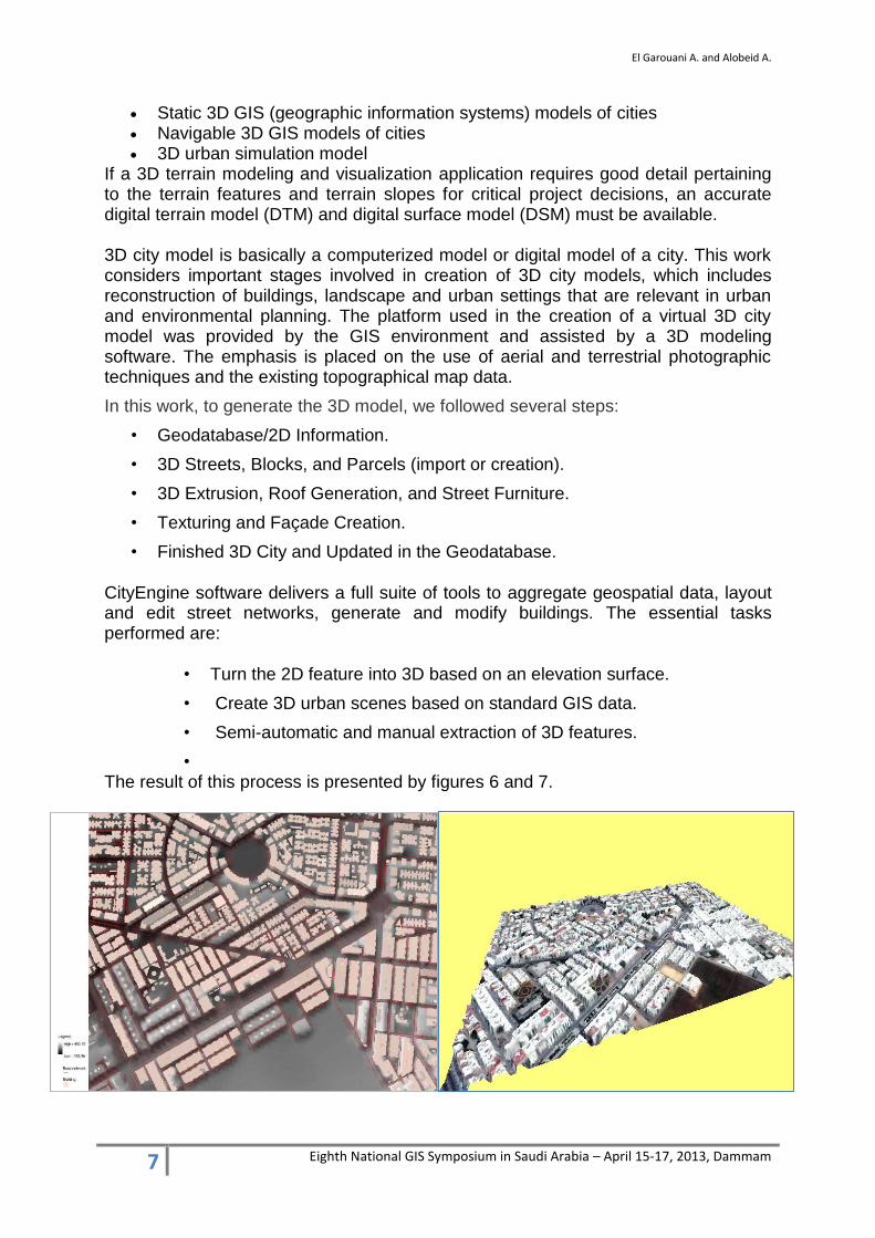
• The result of this process is presented by figures 6 and 7.
El Garouani A. and Alobeid A.
8 Eighth National GIS Symposium in Saudi Arabia – April 15-17, 2013, Dammam
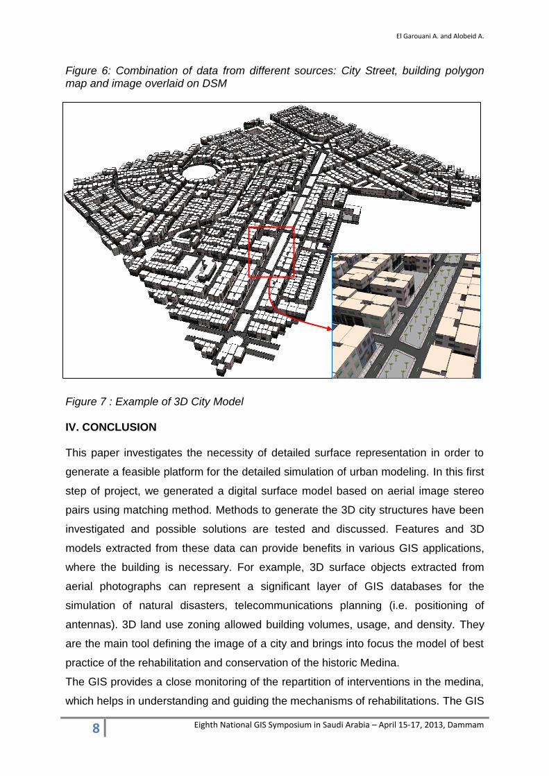
Figure 6: Combination of data from different sources: City Street, building polygon map and image overlaid on DSM Figure 7 : Example of 3D City Model IV. CONCLUSION This paper investigates the necessity of detailed surface representation in order to
generate a feasible platform for the detailed simulation of urban modeling. In this first
step of project, we generated a digital surface model based on aerial image stereo
pairs using matching method. Methods to generate the 3D city structures have been
investigated and possible solutions are tested and discussed. Features and 3D
models extracted from these data can provide benefits in various GIS applications,
where the building is necessary. For example, 3D surface objects extracted from
aerial photographs can represent a significant layer of GIS databases for the
simulation of natural disasters, telecommunications planning (i.e. positioning of
antennas). 3D land use zoning allowed building volumes, usage, and density. They
are the main tool defining the image of a city and brings into focus the model of best
practice of the rehabilitation and conservation of the historic Medina.
The GIS provides a close monitoring of the repartition of interventions in the medina,
which helps in understanding and guiding the mechanisms of rehabilitations. The GIS
El Garouani A. and Alobeid A.
9 Eighth National GIS Symposium in Saudi Arabia – April 15-17, 2013, Dammam
of Fez is an edge management tool for the conservation data and supervision of
projected and implemented projects.
ACKNOWLEDGMENT: The authors wish to thank the Sidi Mohamed Ibn Abdellah
University (Fez, Morocco) and the German Academic Exchange Service: Deutscher
Akademischer Austauschdienst (DAAD) for the funding of this research conducted at
the Institute of Photogrammetry and GeoInformation (IPI), Leibniz University
(Hannover, Germany) and at the Faculty of Science and Techniques (Fez, Morocco).
The authors also thank Dr. F. Rottensteiner, Dr. K. Jacobsen and Prof. C. Heipke,
Director of IPI for their support.
REFERENCES Alobeid, A., Jacobsen, K. & Heipke, C. (2010) - Comparison of Matching Algorithms
for DSM Generation in Urban Areas from Ikonos Imagery. Photogrammetric Engineering & Remote Sensing, 76(9). pp. 1041-1050.
Baltsavias, E. & Stallmann, D., (1993) - SPOT stereo matching for Digital Terrain Model generation. Proc. of 2nd Swiss Symposium on Pattern Recognition and Computer Vision, pp. 61-72, Zurich, 1993
Büyüksalih, G.; Jacobsen, K (2007) - Comparison of DEM Generation by Very High Resolution Optical Satellites: EARSeL. Band "New Developments and Challenges in Remote Sensing". Rotterdam : Millpress, Warschau, 2007, S. 627-637
El Garouani A., Barry R. A., El Garouani S., & Lahrach A. (2012) - Geospatial database template for urban management in Fez (Morocco). Journal of Geographic Information System, Vol. 4, N° 4, 2012, pp. 335 - 340, DOI: 10.4236/jgis.2012.44038
El Garouani A., Barry R. A. & Lahrach A. (2011) - GIS for City Planning, Cas of Fez (Morocco). GTC 2011, Geomatics Technologies in the City, First International Geomatics, Symposium, 10 – 13 May 2011, Jeddah, Saudi Arabia
El Garouani A. (2009) - DEM/DSM generation from satellite images: Application in 3D City and urban modelling. Scientific report of visit to Institute of Photogrammety and Geo-Information, Hannover, Germany.
ERDAS, (2010) - LPS: Project Manager, User’s Guide. ERDAS, Inc. Norcross, GA 30092-2500 USA. 443 p.
Gruen A., Kocaman S., Wolff K., (2007) - High accuracy 3D processing of stereo satellite images in mountainous areas. Dreilaendertagung 2007, Muttenz-Basel, Switzerland, 19-21 June.
Jacobsen, K., 2004: DEM Generation by SPOT HRS. ISPRS Congress, Istanbul 2004, Int. Archive of the ISPRS, Vol XXXV, B1, Com1, pp 439-444

El Garouani A. and Alobeid A.
10 Eighth National GIS Symposium in Saudi Arabia – April 15-17, 2013, Dammam
Kwoh, L.K, Liew, S.C. & Xiong, Z., (2004) - Automatic DEM generation from satellite image. The 25th Asian Conference & 1th Asain Space Conference on Remote Sensing November 22 - 26, 2004, Thailand.
Remondino, F., Gruen, Armin & Zhang, L. (2006) - High-Resolution Satellite Imagery for 3D Modeling and Visualization of Cultural Heritage Sites. The Journal of Survey. V. 56, 30-33
Rottensteiner, F.; Fraser, C.; Weser, T. (2008) - Georeferencing and orthoimage generation from long strips of ALOS imagery: ALOS PI Symposium. Rhodos, 2008, CD, 7 S.
Toutin, T. (1995) - Generating DEM from Stereo Images with a Photogrammetric Approach: Examples with VIR and SAR Data. EARSeL Journal “Advances in Remote Sensing”, Vol. 4, No. 2, pp. 110-117, 1995.
Toutin T. & Gray, L. (2000) - State-of-the-art of elevation extraction from satellite SAR Data. ISPRS Journal of Photogrammetry and Remote Sensing, Vol. 55, No 1, pp. 13-33
Zhang, L., Pateraki, M. & Baltsavias, E., (2002) - Matching of IKONOS Stereo and Multitemporal Images for DSM Generation. Proc. Map Asia 2002, Asian Conf. on GIS, GPS Aerial Photography and Remote Sensing, 7– 9 August, Bangkok, Thailand. (on CD ROM).


![Broch FEZ Domino[1]](https://img.pdfslide.us/doc/110x75/5571faef4979599169938a64/broch-fez-domino1.jpg)