Embed Size (px)
Citation preview
N.T. S.
LAT. 49'45.5"
DIAMOND D R I L L I N G REPORT
ON
THE RAINBOW CLAIM GROUP,
NANAIMO MINING D I V I S I O N
u)c c ~ ~ f i ~ s
92F/14W, 9Z f / /&
LONG. 1 2 5 " H W 140
OF
OWILL,-- fa BETTER RESOURCES LIMITED / " ;
OCTOBER., 1986 RICHMOND, B.C.
J a m e s F. B r i s t o w P. E n g .
DIAMOND DRILLING REPORT
THE RAINBOW CLAIM GROUP ON
TABLE-OF CONTENTS PAGE
................................................... GENERAL LOCATION MAP 1
SU.Y 2 ................................................................ INTRODUCTION ........................................................... 2
LOCATION AND ACCESS .................................................... 2
TOPOGRAPHY AND CLIMATE ................................................. 2
HISTORY ................................................................ 4
PROPERTY DESCRIPTION ................................................... 4
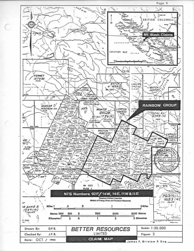
MINERAL CLAIM filAP ...................................................... 6
DISCUSSION ............................................................. 7
COST STATEMENT ......................................................... 8
AUTHOR'S QUALIFICATIONS & CERTIFICATION ................................ 9
AP P END1 X
1) INVOICES ........................................................... 10
3 ) ASSAY CERTIFICATES ................................................. 12 2) DIAMOND D R I U LOG .................................................. 11
J a m e s F . B r i s t o w P . E n g .
.-
OuRCES
James F. B r i s t o w P. Eng.
Page 2 .
SUMMARY
One NQ wi re l ine diamond d r i l l ho le t o t a l l i n g 61 metres w a s d r i l l e d on the Rainbow C l a i m Group. This ho le confirms t h e presence of economic grade gold values wi th in brecc ia ted karmutsen volcanics which form the southwest margin of t h e Murex Breccia body.
Cost of t h e d r i l l i n g programme was i n excess of $ 10,000.00.
INTRODUCTION
This r epor t conta ins the r e s u l t s obtained from 61 metres of NQ w i re l ine diamond d r i l l i n g conducted on the Rainbow Claim Group between 25 August 1986 and 28 August 1986 by Globe D r i l l i n g Ltd. of Vancouver B r i t i s h Columbia.
LOCATION AND ACCESS
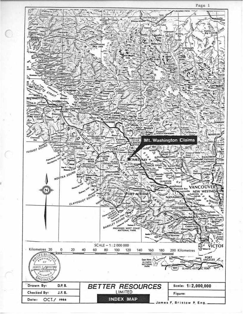
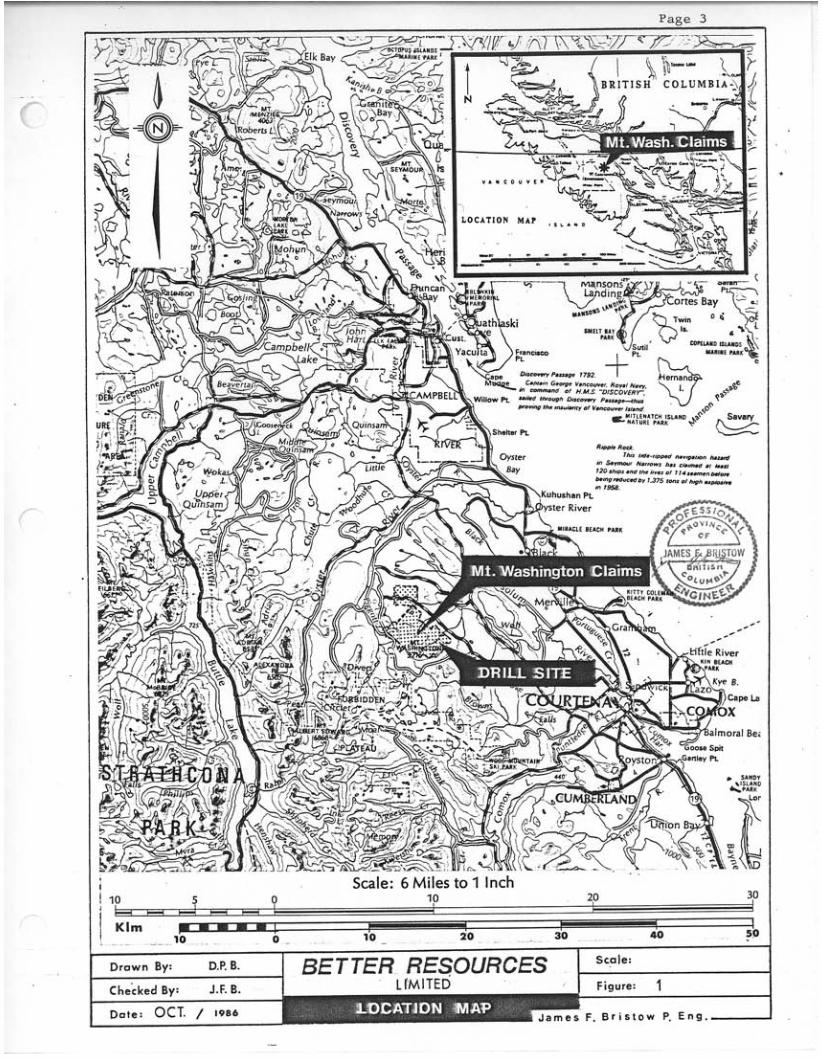
The Rainbow Group of Mineral Claims a r e cent red on Lat i tude 49'45.5'
The claims a r e loca ted approximately 20 North, Longitude 125O15' West wi th in map shee t s N.T.S. 92F/llW, 92F/14W and t h e Nanaimo Mining Divis ion. k i lomet res northwest of Courtenay, B.C. approximately 0.5 k i lomet res e a s t of t h e summit of M t . Washington. Group encompasses the Murex Creek bas in and immediately ad jo in ing a reas . Figure 2 ) .
The western claim boundary is loca ted
(See The claim
Access t o the claims i s by a network of w e l l maintained paved and grave l mining and logging roads. Depending on snowfal l and runoff condi t ions access t o wi th in 1.0 k i lomet res of any point on t h e property i s usua l ly poss ib le by four wheel d r i v e veh ic l e between J u l y and November.
TOPOGRAPHY AND CLIMATE
M t . Washington is loca ted along the e a s t e r n margin of the northwest t rending Vancouver I s l and Ranges i n t h e I n s u l a r Bel t . charac te r ized by moderate t o p rec ip i tous topography covered gene ra l ly , by a th i ck mixed coni fe rous f o r e s t of hemlock, red and yellow cedar , douglas f i r and balsam f i r . cu r ren t ly covered by th i ck inpenet rab le second growth. heather and krumholtz is developed above 1500 metres. Property e l eva t ions range from 300 metres t o 1480 metres. by c i rque development, g l a c i a l s t r i a e and t h i n t o moderate but pervasive g l a c i a l till development.
The landscape i s
Local ly t h i s f o r e s t has been ex tens ive ly logged and is A subalpine f o r e s t of
Evidence of recent g l a c i a t i o n i s noted
October t o May i s charac te r ized by cold and wet weather with cons iderable snow accumulations. of snow may p e r s i s t i n she l t e red a r e a s wel l i n t o t h e summer months. through September a r e d r i e r with temperatures ranging from near f r eez ing t o g r e a t e r than 25OC.
Depth may exceed 5 metres a t higher l e v e l s where patches June
J a m e s F. B r i s t o w P. E n g . I
10 20 30 ~
10 5 0
I I rn n 10 20 30 40 50 ' Klm c - - - - ! I 1
F. B r i s t o w P, E n g .
-
Page 4
HISTORY
Since 1940 the M t . Washington a rea has been t h e focus of sporadic in t ens ive explora t ion a c t i v i t y .
The fol lowing chronological summary from K.E. Northcote 's r epor t dated May 1983, covers t h e time span from discovery of gold minera l iza t ion i n 1940 t o 1982.
"Gold minera l iza t ion was discovered i n p lace on M t . Washington i n May 1940 by J . M . McKay, a young mining engineer and prospector who sys temat ica l ly panned creeks up from t h e Oyster River t o f i n d course co lours i n a creek dra in ing i n t o McKay Lake. trenched and sampled under the d i r e c t i o n of D r . D.F. Kidd i n 1940 - 41. I n 1944 - 45 Karl Springer financed a d i t s on the copper bear ing ve ins nor th of t h e a rea sampled f o r gold. Washington Copper Co. Ltd. w a s formed i n 1956 by Gordon C. Murray and var ious j o i n t agreements and opt ions with Noranda and Cominco explored the property u n t i l 1964. From 1964 t o 1966 M t . Washington under rev ised agreement with Cominco and a j o i n t Venture with Cumberland Mining Co. mined and mil led 392,173 tons of 1.16% Cu, 0.01 oz per ton Au and 0.5 oz per ton Ag. Upon exhaustion of economic open p i t copper minera l iza t ion the m i l l was dismantled.
The gold bearing s t r u c t u r e s were prospected,
M t .
The property was optioned by Mariet ta Resources Company Ltd. i n 1969 f u r t h e r explored by M t . Washington i n 1970 - 71 and then optioned t o Imperial O i l from 1973 t o 1982. During t h i s l a t t e r per iod the explora t ion emphasis appears t o have been d i r ec t ed towards a search f o r more ex tens ive copper mineral iz- a t i o n with l i t t l e explora t ion f o r gold."
I n May, 1983, Bet te r Resources Limited acquired v i a Veerman Botel Limited, an opt ion on a block of claims previously con t ro l l ed by M t . Washing- ton Copper Co. Ltd. By 1984, t h i s land pos i t i on w a s expanded t o 130 u n i t s and a programme t o a s s e s s the a reas precious metal p o t e n t i a l was i n i t i a t e d . the sp r ing of 1986 t h e land pos i t i on w a s expanded t o approximately 230 units. Two diamond d r i l l s a r e c u r r e n t l y opera t ing cont inuously t o expand and d e l i n e a t e known precious metal occurances previously found by t renching , s o i l geochemical surveys and prospect ing.
PROPERTY DESCRIPTION
By
The Rainbow Claim Group owned by Be t t e r Resources Limited of Vancouver, B r i t i s h Columbia, is comprised of the following contiguous two pas t mineral claims as shown i n f i g u r e 2.
1 J a m e s F. B r i s t o w P, E n g . 2
Page 5
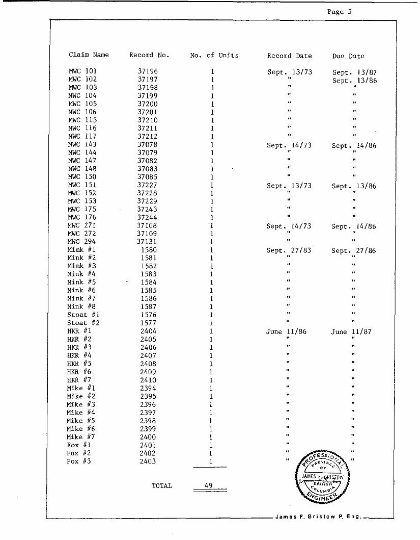
C l a i m Name
MWC 101 MWC 102 MWC 103 MWC 104 MWC 105 MWC 106 MWC 115 MWC 116 MWC 117 MWC 143 MWC 144 MWC 147 MWC 148 MWC 150 MWC 151 MWC 152 MWC 153 MWC 175 MWC 176 MWC 271 MWC 272 MWC 294 M i n k #1 Mink #2 Mink #3 Mink #4 M i n k #5 Mink #6 Mink 117 Mink #8 S toa t #1 S toa t #2 HKR #1 HKR 112 HKR #3 HKR f14 HKR 115 HKR #6 HKR #7 Mike #l Mike #2 Mike #3 Mike #4 Mike #5 Mike #6 Mike #7 Fox #l Fox 112 Fox 13
Record No.
37196 37197 37198 37199 37200 37201 37210 37211 37212 37078 37079 37082 37083 37085 37227 37228 37229 37243 37244 37108 37109 37131
1580 1581 1582 1583
. 1584 1585 1586 1587 1576 1577 2404 2405 2406 2407 2408 2409 2410 2394 2395 2396 2397 2398 2399 2400 2401 2402 2403
No. of Units
1 1 1 1 1 1 1 1 1 1 1 1 1 1 1 1
1 1
1 1
1 1 1 1 1
1 1 1 1
TOTAL 49
Record Date Due Date
Sept. 13/73 Sept . 13/87 Sept . 13/86
Sept . 14/73 Sept. 14/86
Sept . 13/73 Sept . 13/86
Sept . 14/73 Sept. 14/86
Sept . 27/83 Sept . 27/86
June 11/86 June 11/87
I J a m e s F. B r i s t o w P, E n g . 2
. . .~ ~.
F. B r i s t o w P. E n g .
Page 7
DISCUSSION
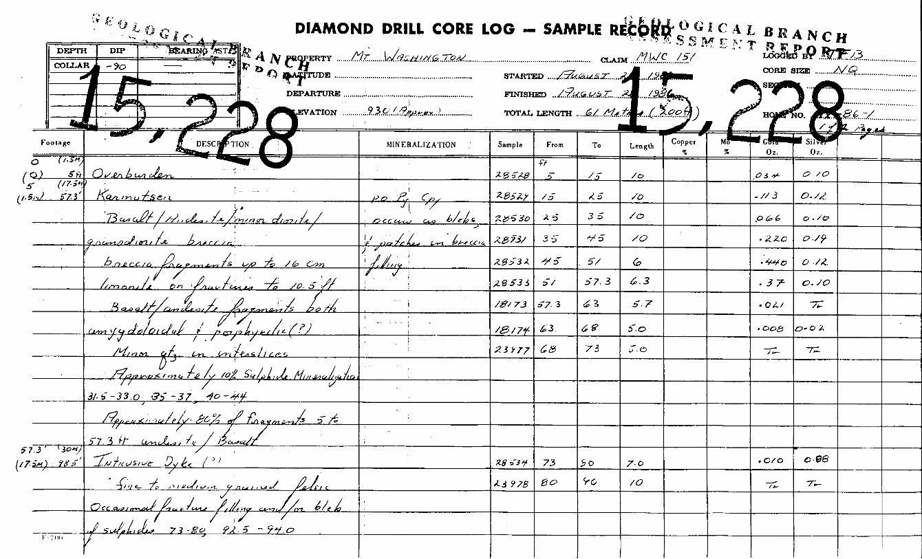
The genera l geology of t h e Mt. Washington area shows a th ick sequence of T ras s i c Karmutsen volcanics ove r l a in by sediments of t h e Cretaceous Comox formation. Both sequences a r e cu t by i n t r u s i v e f e ldspa r porphyry and d i o r i t i c dykes and sills of T e r t i a r y age. The formations a r e i n t u r n pierced by brecc ia systems of var ious composition, s i z e , shape and poss ib ly of d i f f e r e n t ages.
One such mul t i s tage brecc ia (Murex Breccia) is loca ted wi th in the Rainbow Limited pas t su r f ace sampling ind ica ted t h e presence of economic C l a i m Group.
grade gold minera l iza t ion wi th in the boundaries of the brecc ia system.
The purpose of NQ s i z e diamond d r i l l hole Mx-86-1 was t o confirm the presence of t h i s minera l iza t ion .
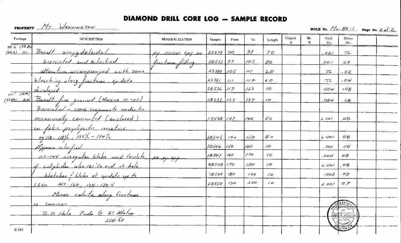
The d r i l l hole i s l o c a t e t o t a l l y wi th in t h e brecc ia body. Fragments vary from a mixture of b a s a l t j a n d e s i t e and a r g i l l i t e near t h e top of t h e hole t o mainly c h l o r i t i z e d amygdoloidal b a s a l t and d i o r i t e fragments near the bottom. Minera l iza t ion occurs as sulphide c l o t t s , i r r e g u l a r blebs and diseminat ions i n t e r s t i c a l t o the brecc ia fragments. P y r r h o t i t e , p y r i t e , and cha lcopyr i te a r e t h e main sulphide minerals . found t o conta in s i g n i f i c a n t gold values .
The top 17.5 metres of the d r i l l ho le w a s
D r i l l i n g t o da t e has not penetrated t h e brecc ia sequence.
The d r i l l core i s c u r r e n t l y s to red wi th in Frankl in E l e c t r i c ' s s to rage yard i n Courtenay, B.C. Drill core was logged by the w r i t e r . The diamond d r i l l i n g program was supervised by Barry Needham or the writer depending on the a v a i l a b i l i t y of personnel.
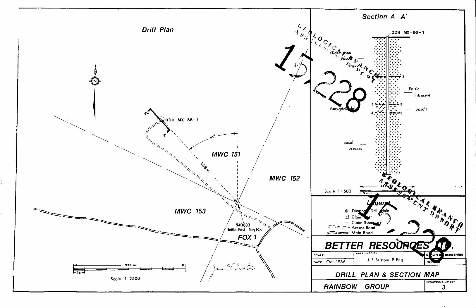
Diamond D r i l l Hole Mx-86-1 w a s surveyed with respec t t o No 1 post Fox #1 claim. This information was used t o prepare a 1:2500 s c a l e Diamond D r i l l Hole Plan (See Figure 3 ) .
A one hole d r i l l s ec t ion was prepared t o accompany the d r i l l ho le plan.
J a m e s F. E r i s t o w P, E n g . 2
Page 8
COST STATEMENT
RAINBOW CLAIM GROW
Location of Drillsite and Access Road
James F. Bristow P. Eng. 22 Aug/86 1 day @ $ 250.00/day
R.D. Bristow 22 Aug/86 1 day @ $ 95.00/day
Drillsite and Access Road Construction
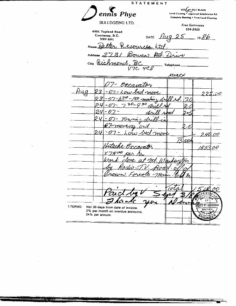
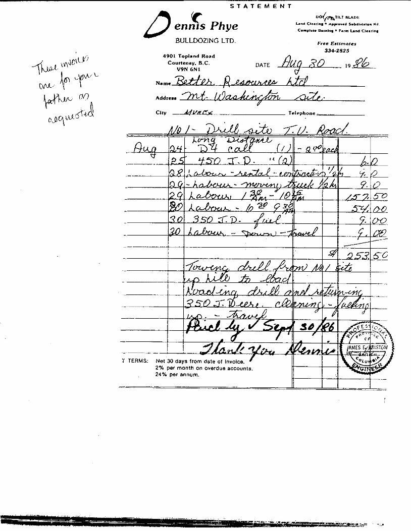
Dennis Pye Bulldozing Ltd. 23/24 Aug/86 As per invoice
Barry Needham 23/24 Aug/86 2 days @ $ 120.00/day
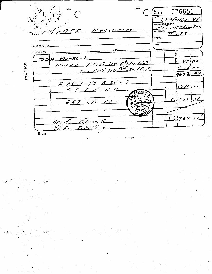
Diamond Drilling (as per invoice) 61 metres @ $ 76.92/metre
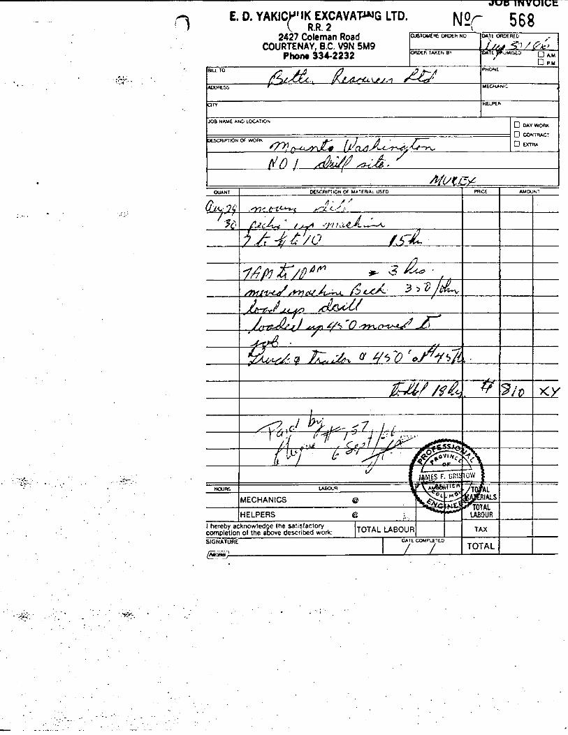
Demobilization E.D. Yakichuk Excavating Ltd. as per invoice
Supervision and Core Logging
James F. Bristow P. Eng. 24 - 31 Aug/86 Total 3 days @ $ 250.00/day
Core Splitting 26,29,30 Aug/86 S Jut 3 days @ $ 95.00/day
Assaying 26 core samples for gold silver
26 @ $ 14.25/sample Sample Freight
4 X 4 Truck Rental 7 days @. $ 25.00/day
Food and Lodging 10 days @ $ 25.00/day
Report Preparation (including drafting & typing)
CERTIFIED CORRECT
, s F. Bristow, P. Eng.
$ 250.00
95.00
1,771.59
240.00
4,692.00
810.00
750.00
285.00
370.50 50.00
280.00
250.00
500.00
$ 10,344.00
I J a m e s F. 8 r i s t o w P, E n g . d
Page 9
QUALIFICATIONS AND CERTIFICATION
I, James F. Bristow, of 3431 Bowen Drive, i n the Municipal i ty of Richmond, Province of B r i t i s h Columbia, hereby c e r t i f y a s follows:
1 ) I a m a graduate of the Universi ty of B r i t i s h Columbia with a B.A. Degree (Geology and Physics)
I a m a Profess iona l Engineer r e g i s t e r e d i n the province of B r i t i s h Columbia.
I am a member of The Associat ion of Explorat ion Geochemists, the Geological Society of South Afr ica and the Canadian I n s t i t u t e of Mining and Metallurgy.
I have a c t i v e l y p rac t i ced my profess ion i n mineral explora t ion and mining geology s ince my graduat ion i n 1957.
That t h i s r epor t is based on da ta e i t h e r gathered by myself or by persons working under my d i r e c t superv is ion .
2 )
3 )
4 )
5)
6 ) That I am a Direc tor of Bet te r Resources Limited and hold a d i r e c t i n t e r e s t i n t h e S e c u r i t i e s of t h i s company.
Dated a t Richmond, B r i t i s h Columbia, t h i s 3 . , d day of November 1986.
P. Eng. / ’
J a m e s F. E r i s t o w P. E n g . 2
Page I0
APPENDIX I
INVOICES
, -.-.I . .
.
.. .
B 032
. .
. - '
2427 Coleman Road COURTENAY, B.C. V9N 5M9
Phono 33&2232
CUSTOMER5 ORDEW NO
O f W R TAKEh BY
L . . . . ... . .
BJLL TO
ADDRESS
UlY
.::. ....
mwt
MECMNIL
nEmk
. . -;'-. .. .<v-. . . . . ..... ...... . . . .
. ;+.- . * . . ..
. . .
S T A T E M E N T D en;% Phye BULLDOZING LTD.
Free Estlmotcs 334-2825
4901 Topland Road
V9N 6N1 Courtcnay, B.C. DATE .&g 2 5 1 9 # 6
Clty Telephone
1 TERMS: Net 30 days from date of invoice. 2% per month on overdue accounts. 24% per annum.
~
S T A T E M E N T
‘c ennis Phye BULLDOZING LTD.
4901 Topland Road Courtenay. B.C.
V9N 6N1
Land C l e a r l y nppwowed Subdlwlelon Hd
Complrt. Bumlnm Farm Land ‘Clearing
Free Estimates 334-2825
d
A Clty Telephone 8
- 7’ TERMS: Net 30 days from da
2% per month on ov 24% per annum.
II 1 - ---_ - -
I
Page 11
A P P E N D I X I1
DIAMOND D R I L L LOG (Mx-86-1 i n pocket)
APPENDIX I11
Page 12 I
J a m e s F. B r i s t o w p. E n g .
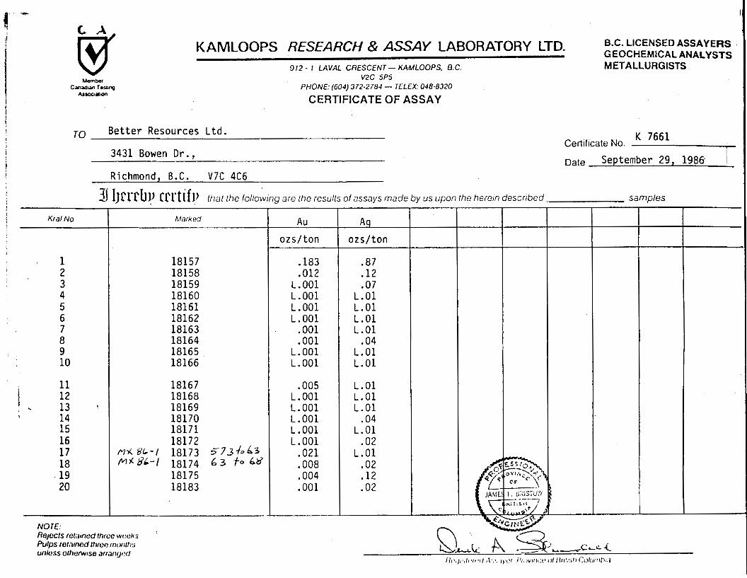
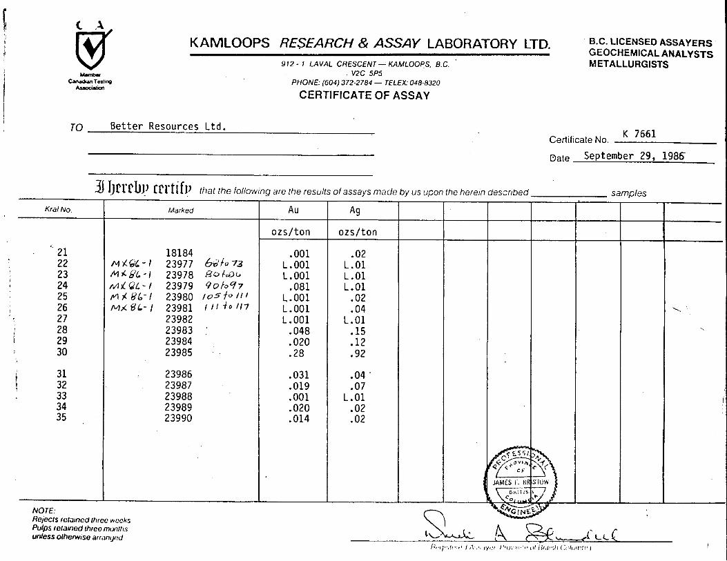
ASSAY CERTIFICATES
U.C. LICENSED ASSA'IEflS
M ETALLU R G I STS G E OC H E !#I I C A L F\ F i A L y STS KAMLOOPS RESEARCH & ASSAY LABORATOHY LTD.
! I 1 2 - I LAVA1 CfiCSCCPdT - KAhlLOOPS, fJ C v2c 5P5
PtiONC: (GO.!) 372-2784 - TELEX: 048-0320
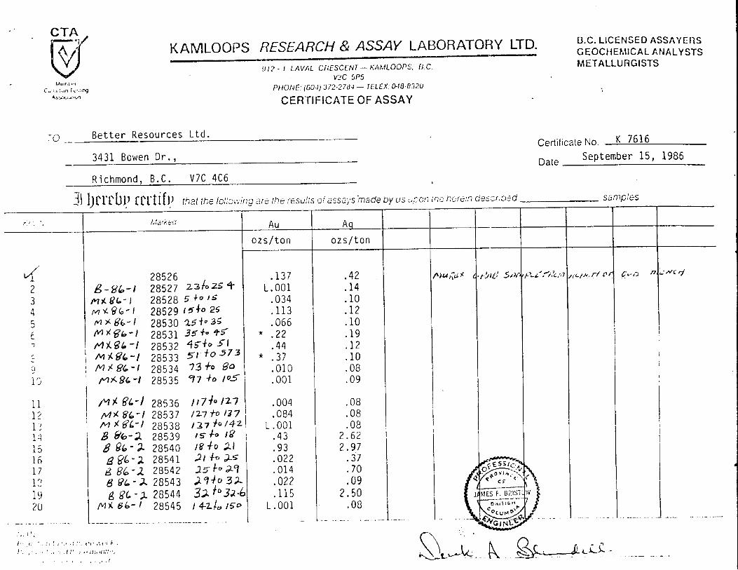
CERTIFICATE OF ASSAY I

I - -?-. Better Resources L t d . - K 7616 - 2 Certificatt? b!o.
KAMLOOPS RESEARCH & ASSAY LABORATORY LTD. 912 - 1 LAVA1 CRESCENT- KAMLOOPS, 6.C.
v2c 5P5 PHONE: (604) 372-2784 - TELEX: 048-8320
B.C. LICENSED ASSAYERS GEOCHEMICAL ANALYSTS METALLURGISTS
. I
CERTIFICATE OF ASSAY
B e t t e r Resources L t d . TO
3431 Bowen D r . ,
Richmond, B.C. V 7 C 4C6
K 7661 I Certificate No.
Date September 29, 1986 1
3 IJrrcbl! r u t if!) that the following are the results of assays made by us upon the herem described samples
I
KAMLOOPS RESEARCH & ASSAY LABORATORY LTD. 912 - 1 LAVAL CRESCENT - KAMLOOPS, B.C.
v2c 5P5 PHONE: (604) 372-2784 - TELEX: 048-8320
CERTIFICATE OF ASSAY
TO B e t t e r Resources L t d .
B.C. LICENSED ASSAYERS GEOCHEMICAL ANALYSTS M ETA LLU R G ISTS
I Date September 29, 1986
I
\ \
MWC 153
Drill Plan
Section A - A ’
/DDH MX-86-1
-.-
-= Main Road
RAINBOW GROUP
250 m. * I I I 1 b I I 4 m 4
I I 1 3
Scale 1 ~ 2 5 0 0
MWC 152
1 DIAMOF
5
U G l C A L BJp . '. ' . ;i.f s s n.fl 8' h* t A N c n
s. :. -,. ~- +
ID DRILL CORE LOG - SAMPLE RE&b&$
/yI.Jc I%%&@ .?WG .......................... ............................................................... CLAIM .............................
I
I I
I I
I I I
I I 1 I I I I 1
i I I
I 1
I 1
I I
I I I I 1 I