Embed Size (px)
Citation preview
United States Department of Agriculture Forest Service October 2012
Decision Memo Diamond Creek Exploration Drilling Project
Salmon-Cobalt Ranger District Salmon-Challis National Forest Lemhi County, Idaho
T.23 N., R.21 E. – sections 26 and 35, Boise Prime Meridian, Lemhi County, Idaho.
.

The U.S. Department of Agriculture (USDA) prohibits discrimination in all its programs and activities on the basis of race, color, national origin, age, disability, and where applicable, sex, marital status, familial status, parental status, religion, sexual orientation, genetic information, political beliefs, reprisal, or because all or part of an individuals income is derived from any public assistance program. (Not all prohibited bases apply to all programs.) Persons with disabilities who require alternative means for communication of program information (Braille, large print, audiotape, etc.) should contact USDA's TARGET Center at (202) 720-2600 (voice and TDD). To file a complaint of discrimination, write to USDA, Director, Office of Civil Rights, 1400 Independence Avenue, S.W., Washington, DC 20250-9410, or call (800) 795-3272 (voice) or (202) 720-6382 (TDD). USDA is an equal opportunity provider and employer.
Diamond Creek Exploration Drilling Project Decision Memo
-1-
DECISION I have decided to conditionally approve a Plan of Operations (Plan) to conduct exploration for minerals. The project area is located in the Diamond Creek drainage within the Salmon-Cobalt Ranger District, Salmon-Challis National Forest, Idaho (Figure 1). This memo documents the rationale for conditionally approving the proponent’s Plan to core drill on previously disturbed ground on or adjacent to existing two-track roads. The project will not authorize any new system roads, temporary roads or trails or change the status for motorized routes in the Salmon-Challis NF Motor Vehicle Use Map (MVUM) (also known as the Travel Plan). The total area of disturbance will be less than 2.0 acres. Equipment will include an excavator or backhoe, a track-mounted core drill, ATVs, and 4WD pick-up trucks. All proposed activities will be greater than 300 feet from live water. The Plan approval under this decision will be contingent on the operator’s acceptance of the terms and conditions specified below and collection of a bond for reclamation.
PURPOSE AND NEED Background Minex Exploration submitted a Plan of Operations on March 28, 2012 to conduct mineral exploration on National Forest System (NFS) lands. They are proposing exploratory core drilling at two locations within the Diamond Creek drainage. Activities will occur on the Salmon-Cobalt Ranger District, Salmon-Challis National Forest. Legal description for the area is T.23N., R.21E., Sections 26 and 35, Boise Meridian, Lemhi County, Idaho. The project area is in Management Prescription 5B and will be accessed via Forest Service Roads 60129, Diamond Creek, and FSR 60249, Diamond Cutoff (Figure 1).
After consideration of the proposal, site visits by an interdisciplinary team, clarifications from the project proponent, interdisciplinary development of project design criteria, and review of the project file including public scoping measures, I have determined that the exploration activities may be conducted while protecting other surface resources, as required by applicable laws and regulations and the agency direction described below.
Forest Service Minerals Regulations Forest Service policy in Title 36 Code of Federal Regulations Part 228 (36 CFR 228.1) states that use of the surface of National Forest System lands in connection with operations authorized by the United States mining laws (30 U.S.C. 21–54), which confer a statutory right to enter upon the public lands to search for minerals, shall be conducted so as to minimize adverse environmental impacts on National Forest System surface resources.
Diamond Creek Exploration Drilling Project Decision Memo
-2-
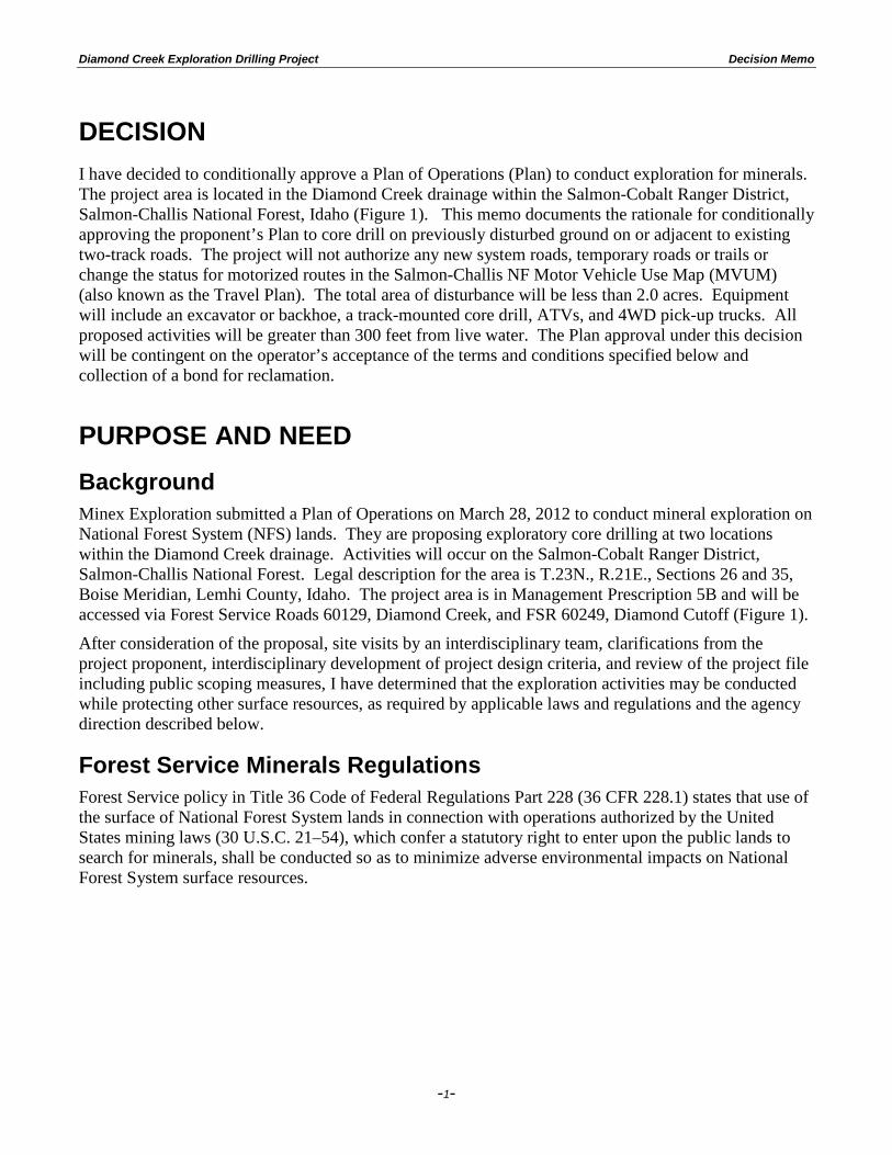
Figure 1. Map of exploration roads and project activities.
Forest Service Manual Direction Relevant policy in the Minerals and Geology Manual (FSM 2802) states that the Forest Service will:
1. Encourage and facilitate the orderly exploration and development of mineral and energy resources on National Forest System lands to maintain a viable, healthy minerals industry, and
2. Ensure that exploration, development, and production of mineral and energy resources are conducted in an environmentally sound manner.
Forest Plan A Forest-wide goal set forth in the Salmon National Forest Land and Resource Management Plan1 (Forest Plan) is to:
1 Land and Resource Management Plan for the Salmon National Forest, 1988, USDA Forest Service
Diamond Creek Exploration Drilling Project Decision Memo
-3-
1. Encourage the legitimate exploration and extraction of leasable and locatable minerals from National Forest lands while maintaining or improving other resource values (IV-3).
Relevant direction in the Forest Plan also includes:
1. On unclassified lands, minerals and energy activities will be managed to prevent unreasonable and unnecessary surface disturbance during operations, and to provide for reclamation of disturbed lands after operations cease (IV-49).
The project is located in Management Prescription 5B, which allows for mineral exploration subject to Forest Plan direction (IV-129).
Because the proposed exploration activities, in conjunction with the required project design criteria, will have no significant impacts on the surface resources managed by the Forest Service, I have decided to conditionally approve the proponent’s Plan. This decision is based on the environmental analyses in the project file that show other surface resources will be protected, as required by federal law and Forest Service minerals regulations and policy, and that the project complies with the Salmon National Forest Land and Resource Management Plan.
PROPOSED ACTION The proposed action is to approve Minex Exploration’s March 28, 2012 Plan of Operations in conjunction with the design criteria and project monitoring requirements specified below. This decision is only for the activities described in this document. If the proponent intends to use other methods or plans additional activities, the proponent is required to submit a revised, supplemental, or new Plan of Operations and the proposed operations would be reviewed with additional site-specific analysis and public scoping. A separate decision and approval would be required.
Plan of Operations Core drilling is proposed at two locations using a track-mounted core drill. One to two holes may be drilled at each location. These two drilling locations are within existing disturbance (i.e. on existing roads and/or in areas of previous mineral exploration). Drill holes will be a maximum of 400 feet deep and three inches in diameter. Drill locations will be leveled with a D-3 or equivalent size dozer, excavator, or backhoe, and will be 24 feet by 22 feet with a staging area and sumps. Total disturbance at each drill site will not exceed 750 ft2. This same equipment will be used to open closed spur roads, and to close these roads to their approximate pre-exploration condition at the end of the operation. When drilling is complete, each drill hole will be filled from the total depth to the collar with cement grout or bentonite slurry and capped. Sumps will be backfilled, sumps and pads will be recontoured to grade, and revegetated with an approved seed mixture and certified weed-free mulch.
There will be no new road construction. One closed road (U232135J) will be re-opened for the drill rig and support vehicle access, and will be closed at the end of operations. No trees above 7” dbh will be removed to allow access.
Total disturbance is expected to be less than 2.0 acres, including road re-opening. All proposed drilling activities are greater than 300 feet from live water, with the exception of a small seep near drill site #1. A temporary drainage structure may need to be placed at this location to minimize disturbance and facilitate travel until drilling operations are complete. The company has proposed a project start-up of Fall 2012 or Summer 2013 with completion of drilling and associated reclamation by the end of October 2013. The operator will be required to post a bond to ensure the reclamation of all disturbance.
Diamond Creek Exploration Drilling Project Decision Memo
-4-
Water drafting will be from Diamond Creek (Idaho Department of Water Resources Temporary Permit #TP-75-88) where it crosses FSR 60129 on NFS administered lands, either by pump directly into the water truck, or by gravity feed into a storage tank from which water would be pumped into the water truck. There will be no discharge to waters of the U.S. In the event that the proposed drafting location is dry when the project is implemented, or that a temporary water right has not been obtained, water for drilling would be trucked to the site from off-Forest, and then stored in 500-1000 gallon tank(s). Water will be recirculated from the sumps when possible. The water truck will haul water only as needed to accomplish drilling, estimated to be not more than two trips per 12-hour shift. A maximum of 3000 gallons of water per 12-hour shift will be necessary. Water in sumps will be decanted or allowed to percolate into the ground. Sumps will be refilled at time of reclamation, covered with topsoil, and the surface re-contoured. Following re-contouring, an appropriate seed mix and certified weed-free mulch will be applied.
Equipment not in use will be parked at the staging area for each drill site. A portable toilet may be located there. This area will also be used for core logging/cutting.
Secondary containment will be used for all petroleum products and drilling media at the site. Spill kits will be placed at fuel transfer sites. All containers will be labeled as to their contents. Fire prevention tools will also be kept on-site. If a reportable quantity of a hazardous substance is released, it will be reported to the Forest Service immediately. Any contaminated soils will be removed to an approved disposal/treatment facility.
If cultural artifacts are found, excavation will stop and the Forest Service will be notified.
Project Design Criteria Terms and conditions of my approval of the proposed Plan of Operations will include the items listed below (and attached Appendix B). The proponent must formally agree to implement these design criteria (management requirements and constraints) prior to Plan of Operations approval.
Approvals, Access, Requirements 1. The operator will notify the Forest Service (FS) a minimum of three days in advance prior to
commencing initial activities. Prior to commencing activities the FS Administrator, Operator, and contractor shall review locations for drilling.
2. Appendix B contains a comprehensive list of mitigation measures that will be required as modifications of the Operator’s plan. These mitigation measures are contained in the Forest Land and Resource Management Plan (FLRMP) (IV-51 item 1a and Appendix C VII-C-pg. 1-14), and are the standards and guidelines for locatable minerals operations that occur on the Forest.
Water Quality and Fisheries 3. Water for drilling would be drafted or gravity fed from Diamond Creek and stored at the
drafting site in 500-1000 gallon tanks and used as needed, or directly trucked to the drill sites and stored in tanks there.
4. Logs or coarse rock will be placed in the wet area near drill site #1 to allow for water seepage across the road prism, and will be removed when drilling operations have concluded.
5. Project activities will be conducted when site conditions are conducive to minimizing impacts on soil and water resources. Activities will not be allowed when roads and exploration area are
Diamond Creek Exploration Drilling Project Decision Memo
-5-
very wet and excessive road rutting or soil compaction would occur. Dry conditions should generally exist from July 15 until October 1. Operations outside of this period will be agreed to by the Operator and the Forest Service.
6. The existing closed Forest Service Road (U232135J) will be minimally cleared (only larger boulders, rocks and minimal slough material) for an approximate distance of 0.5 miles to allow for 4-wheel drive and support vehicle access. Leaving vegetation, smaller rocks and harder material on the existing road surface during operations will aid in sediment retention and stability of the road.
7. The operator shall minimize any vegetation removal on and near existing road prism during the road opening process, however, the clearing of grass and brush from access routes may be needed to reduce fire hazard.
8. Any debris (rocks, loose gravel, unused fill material) removed during this process will be placed in a suitable location and later used for reclamation purposes. No debris will be placed on the down-hill side of the access road to aid in the prevention of sediment transport or rolling debris.
9. Only one drill hole may be left open at one time. Drill pads and sumps will be reclaimed once operations are complete at that location.
10. Equipment staging areas and fuel storage shall be located at least 300 feet from any streams and be placed inside secondary containment of sufficient capacity to contain any spilled fuel, ensuring that petroleum products will not enter any stream in the event of spills or leaks. The FS shall approve all fuel storage areas and spill plans. Oil pans will be positioned under all parked vehicles on site.
11. The operator will be required to have a spill response cache in the project area and a spill response kit in all equipment that will be operating near streams (i.e. pumps).
Wildlife and Plants 12. Should any unusual plant species be found in the the TES Plant Action Area, they will be
evaluated to determine if they are Threatened or Endangered, and if so, appropriate mitigation measures would be implemented by the USFS. Potential mitigation measures are detailed in the Wildlife and Rare Plants Specialist Report (Project File, Supervisor’s Office).
13. Should an active TES or sensitive species den be found in or near the project area, US Fish and Wildlife Service will be notified and appropriate mitigation measures as determined by the USFS and USFWS would be implemented to avoid disturbance to and/or abandonment of the den, if necessary. Potential mitigation measures are detailed in the Wildlife and Rare Plants Specialist Report (Project File, Supervisor’s Office).
14. Should an active TES or sensitive species raptor nest be found within 0.5 miles of the project site while project activities are on-going, the Salmon LRMP standard of a 0.25-0.5 mile radius “no activity” buffer will be implemented while unfledged young are present.
15. Mesh fencing shall be placed around sumps until they are closed to prevent accidental entrapment of wildlife species.
Weeds 16. Locate and use weed-free staging areas where available.
Diamond Creek Exploration Drilling Project Decision Memo
-6-
17. The operator needs to clean and present equipment used in the operation for an inspection to certify the equipment is clean of weed seeds, reproductive root fragments and mud or other debris that may contain seeds or root fragments.
18. Retain native vegetation in and around project activity to the maximum extent possible, consistent with project objectives. Minimize soil disturbance to the extent practical, consistent with project objectives. All soil-disturbed sites associated with project activities will be monitored for the establishment and/or spread of noxious weeds. Treat all new and existing noxious weed infestations found for eradication.
Reclamation 19. The operator will stockpile the topsoil separately from the subsoil for reclamation. Drill holes
will be filled from depth to collar with cement grout or bentonite slurry and capped. After replacing the topsoil on the capped drill holes, the operator will be required to revegetate the areas as described in #22, below.
20. The operator will be required to backfill and reshape the drill pads and sumps back to the approximate original contour and perform other erosion control measures should they be necessary. Each drill pad and sump shall be reclaimed prior to opening and drilling a new drill pad, core hole, and sump.
21. Final reclamation will include complete re-contouring of any disturbance to the natural contours and the removal of any drainage structures.
22. Revegetate disturbed soils (except travel ways on surfaced projects) in a manner that optimizes plant establishment for that site. Revegetation may include topsoil replacement, placement of large woody debris, planting, seeding, fertilizing and mulching. Use native materials and certified weed-free/weed seed-free hay and straw. A recommended revegetation seed mix will be provided to the operator prior to commencement of activities. Mulch application rates should be approximately one ton per acre.
CATEGORY OF THE PROPOSED ACTION This action is being undertaken because Minex Corporation has submitted a Plan of Operations to conduct exploratory drilling for locatable minerals. This action falls into a category of actions excluded from documentation in an environmental impact statement (EIS) or environmental analysis (EA), as defined in 36 CFR 220.6(e)(8)(vii) and FSH 1909.15, Section 32.2, Category 8:
Short-term (one year or less) mineral, energy, or geophysical investigations and their incidental support activities that may require cross-country travel by vehicles and equipment, construction of less than one mile of low standard road, or use and minor repair of existing roads.
The Diamond Creek Exploration Drilling Project meets the intent of the category because it will authorize approval of less than one full year of operations and requires less than one mile of use and minor repair of existing roads. If, based on the results of this project, Minex Exploration proposes additional exploration; it will be subject to a separate analysis and approval. There are no extraordinary circumstances or other issues that would require the preparation of an EA or EIS.
This project does not individually or cumulatively have a significant effect (40 CFR 1508.27) on the quality of the human environment and, therefore, may be categorically excluded from documentation in
Diamond Creek Exploration Drilling Project Decision Memo
-7-
an EIS or EA. A project or case file and a decision memo are required and were prepared. There are no known or reasonably foreseeable activities associated with this operation.
Scoping and Public Involvement The project was listed in the Forest Schedule of Proposed Actions on July 1, 2012. A display advertisement describing the project and requesting comments was published in the newspaper of record, The Recorder Herald, on May 31, 2012. The Forest Service received two scoping comments in response to that advertisement.
RATIONALE FOR CATEGORICAL EXCLUSION Test for Extraordinary Circumstances An interdisciplinary team made a determination that no extraordinary circumstances related to the proposed action exist. Resource conditions that were considered in determining whether extraordinary circumstances related to the proposed action warranted further analysis and documentation in an EA or an EIS include:
a. Federally listed threatened or endangered species or designated critical habitat, species proposed for Federal listing or proposed critical habitat, or Forest Service sensitive species. This project will have “No Effect” on Threatened or Endangered species and will not modify their habitat (see Findings Required by Other Laws and Regulations section). The project will have “No Impact” or “May Impact, but Not Likely to Adversely Impact” on species listed as sensitive by the Regional Forester. It will not contribute to a trend toward federal listing or cause a loss of viability to populations of sensitive species (see National Forest Management Act and Endangered Species Act sections below; see also project file, Wildlife and Fisheries Biological Assessments and Evaluations).
b. Flood plains, wetlands, or municipal watersheds. No flood plains, wetlands, or municipal watersheds will be negatively impacted by project activities (October 13, 2010 CE Checklist signature -Hydrologist).
c. Congressionally designated areas, such as wilderness, wilderness study areas, or national recreation areas. No project activities will occur in congressionally designated areas such as wilderness, wilderness study areas, or national recreation areas in the project area (Salmon National Forest Land and Resource Management Plan). d. Inventoried roadless areas or potential wilderness areas. The project area is not located within any inventoried roadless areas or potential wilderness areas.
e. Research natural areas. There are no research natural areas in the project area (Salmon National Forest Land and Resource Management Plan).
f. American Indians and Alaska Native religious or cultural sites. There are no known sites that may constitute religious or cultural sites. The area was previously surveyed. No significant sites, traditional use conflicts or other concerns were identified.
Diamond Creek Exploration Drilling Project Decision Memo
-8-
g. Archaeological sites, or historic properties or areas. Drill sites 1 and 2 are located within an area previously surveyed.
Findings Required by Other Laws and Regulations National Forest Management Act This decision is consistent with the Salmon National Forest Land and Resource Management Plan (Forest Plan) as required by the National Forest Management Act. Forest Plan goals encourage the legitimate exploration and extraction of leasable and locatable minerals from National Forest lands while maintaining or improving other resource values (Forest Plan, page IV-3).
Management Prescription 5B, in which the project is located, outlines that the area will be available for the exploration and development of locatable minerals and for leasable minerals and energy resources. (IV-49).
This action is also consistent with Forest Plan and PACFISH amendment goals to minimize impacts to forest health, watersheds and fish and wildlife habitat conditions. The project does not authorize any vegetative manipulation and there are no activities within Riparian Habitat Conservation Areas.
Biological Evaluations for Forest Service Sensitive Species and analysis of Management Indicator Species (MIS) for the Salmon-Challis National Forest have been completed. The project will have “No Impact” for aquatic Sensitive species (Westslope Cutthroat Trout), and “No Effect” on aquatic MIS (Bull Trout) (Fisheries Biological Evaluation); “No Impact” to: fisher,Townsend’s big-eared bat, spotted bat, pygmy rabbit, common loon, harlequin duck, bald eagle, peregrine falcon, northern goshawk, great gray owl, boreal owl, flammulated owl, three-toed woodpecker, yellow-billed cuckoo, Columbia spotted frog (MIS for riparian habitat), pink agoseris, Sacajawea’s bitterroot, Douglass’ biscuitroot, Salmon twin bladderpod, Marsh’s bluegrass, and Idaho range lichen; “May Impact but Not Likely to Adversely Impact” to: wolverine, bighorn sheep, sage grouse, Lemhi penstemon and flexible alpine collomia (Terrestrial Wildlife and Plant Species Biological Evaluation,). Sage grouse is also a MIS for sage-steppe habitat with an additional finding of “not likely to cause a trend to Federal listing or loss of viability” (Terrestrial Wildlife and Plant Species Biological Evaluation).
As required by Forest Plan soil and water and minerals standards, water quality in project area will continue to meet State standards and support beneficial uses and project design will ensure that water quality is maintained. The project is designed to avoid impacts to soil stability and productivity and is located and designed such that no fine sediment will erode or enter stream channels.
The recreational opportunity spectrum designation for the project area is “Semi-Primitive, Motorized” in which interaction between users is low, but there is often evidence of other users. Motorized use off existing routes is not permitted by the project. Because one of the project access routes will be temporarily opened, evidence of mining-related use will be evident during the operations but afterward when the route is closed, the area will revert to existing conditions. Therefore, the project is consistent with this designation.
The project area is located in an area with several routes open to motorized vehicle travel.2 The project does not authorize any new system roads, temporary roads or trails or change the status for motorized routes. The routes to be used are existing open Forest-system routes Diamond Creek Road (FSR60129), Diamond Cutoff (FSR 60249), and .3 miles of an existing undesignated route, which is not open to motorized vehicle use. Regulations at 36 CFR 212.51 (a) (8) provide for exemption to allow for motor vehicle use under a written authorization issued under Federal authority, i.e., Line Officer approval of 2 Salmon-Challis National Forest Motor Vehicle Use Map, Salmon-Cobalt Ranger District, 2012, USDA Forest Service.
Diamond Creek Exploration Drilling Project Decision Memo
-9-
the Plan of Operation. The existing undesignated route to be used for the project will be re-closed to post-project motorized use in accordance with the Salmon-Challis National Forest MVUM (travel plan map).
1955 Multiple Use Mining Act The project retains the management of surface resources for the Forest Service and authorizes surface disturbances that are reasonably incident to the exploration stage of operations within the context of the operator’s rights under the 1872 Mining Law, as amended.
National Environmental Policy Act (NEPA) Use of a Categorical Exclusion and Decision Memo is in compliance with NEPA and the Council on Environmental Quality regulations (40 CFR 1500-1508) for implementing NEPA.
Clean Water Act and Executive Orders 11990 and 11988 No 303(d)-listed (water-quality impaired) stream segments will be affected, and beneficial water uses will be maintained. The activities associated with the project will not result in negative impacts to streams, floodplains, or wetlands.
Endangered Species Act (ESA) This decision is consistent with the ESA. Biological Assessments for fish and wildlife species were completed for the Diamond Creek Exploration Drilling Project. A determination of “No Effect” was made for aquatic ESA species and designated habitat (Chinook Salmon, Steelhead, Bull Trout, Sockeye Salmon). A Biological Assessment of terrestrial ESA animal species for the project resulted in a determination of “No Effect” for Gray Wolf and Canada Lynx (Wildlife Biological Assessment). No ESA listed plant species are present in the project area or on the Forest.
Executive Order 12898 (Environmental Justice) In accordance with Title VI of the Civil Rights Act of 1964, this action does not directly, or through contractual or other arrangements, use criteria, methods, or practices that discriminate on the basis of race, color, or national origin. No disproportionately high and adverse environmental or human health effects on an identifiable low-income or minority population were discovered.
National Historic Preservation Act This operating area was surveyed by a Forest Service Archaeologist and the project was determined to have no affect on cultural resources. The core drilling sites are located within an historic mine site which is not eligible for the National Register of Historic Places. The Idaho State Historic Preservation Office concurred with this finding. The project will proceed with the understanding that if areas of impacts change or become more extensive, or if heritage resources are discovered within the project area, the Forest Archaeologist will be immediately contacted for additional project review prior to implementation of those changes.
Idaho Roadless Area Conservation; Final Rule Project activities are located outside any Idaho Roadless Areas.
Implementation The Salmon-Cobalt District Ranger intends to implement this decision by approving Minex Exploration’s Plan of Operations, provided it incorporates the design criteria itemized in this Decision Memo. Approval will also be contingent upon Forest Service receipt of a financial instrument to insure completion of required reclamation. Implementation will include Forest Service administration of the operation, as required in this decision and minerals regulations at 36 CFR 228 Subpart A.
Diamond Creek Exploration Drilling Project Decision Memo
-11-
Appendix B Management Requirements and Constraints Applicable measures will be required during implementation of Minex Exploration’s March 28, 2012 Diamond Creek Exploration Drilling Plan of Operations. Management Requirements and Constraints to be Incorporated into the Operating Plan: Approvals and Access 1. The operator (Minex Exploration) will notify the Forest Service (FS) Minerals Administrator a minimum of three days in advance prior to commencing initial activities. 2. Prior to commencing activities the FS Administrator and Operator shall review and approve drill pad and sump locations. Noxious Weeds 3. To reduce the threat of introducing exotic weed species, prior to entry onto National Forest System Lands, the operator will be required to power wash the undercarriage and tires/tracks/skids of all exploration equipment such that they are free of dirt and/or caked-mud that may contain weeds or weed seeds. The Forest Service Minerals Administrator will visually inspect all equipment. 4. The Operator will be responsible for eradication of all weeds found within the project area, for a period of two years (2012-2014) in those areas that were disturbed by the operator. Herbicide treatments will be conducted by an Idaho-certified professional weed applicator. 5. All mulch materials, straw bales and seed mixtures used in association with proposed exploration operations shall be certified free of noxious weeds or noxious weed seed to be in compliance with the weed free forage policy for National Forest System lands in Idaho (Special Order #04-00-097; 2/03). Backfilling Drill Pads and Sumps 6. Only one drill hole and sump may be left open at one time. Drill pads and sumps will be reclaimed by filling with materials excavated from the sump[s prior to drilling, covered with stockpiled topsoil and recontoured to original slope. The Operator will notify the Forest Service prior to reclaiming drill pads and sumps in order that the Forest Service may monitor the activity. Reclamation of all test pits will be done once excavation is completed at that location. Water drafting and fuel storage 7. Water drafting will not occur on this project.
Bonding 8. A bond (surety, certificate of deposit, letter of credit, etc.) will be required for the operation. The bond for this operation shall be posted prior to commencing any exploration activities. The amount of the bond will be calculated to ensure full reclamation, weed treatments, and re-vegetation of areas disturbed by the exploration activity. The standards which guide the use and release of the reclamation bond are contained in 36 CFR 228, as well as those documented in the plan of operations. Final Reclamation 9. Reclamation includes concurrent, seasonal, and final activities which are required to minimize surface disturbance, enhance stability, prevent erosion, and return disturbed land to a productive pre-mining condition. Final reclamation will occur at the conclusion of exploration operations. This includes reshaping all disturbed areas back to their original natural contour, reclamation of test pits, seeding, fertilizing, mulching and removal of all equipment. The Operator may be required to treat noxious weeds (see #4 above) if determined necessary by the Forest Service. All mulch materials, straw bales, and seed mixtures used in association with the proposed
Diamond Creek Exploration Drilling Project Decision Memo
-12-
operation shall be certified weed free (see #5 above). 10. A comprehensive list of mitigation measures that will be required as modifications of the Operator’s plan is contained in the Forest Land and Resource Management Plan (FLRMP) (IV-51 item 1a and Appendix C, VII-C-pg. 1-14). They are the standards and guidelines for locatable minerals operations that occur on the Forest. II. LOCATION AND CONSTRUCTION FACILITIES A. Equipment and facilities will be located out of riparian and floodplain areas to the extent practicable.
B. Flagging and markers of any kind must be approved by the Forest Service. Biodegradable ribbon will be used, or alternatively removal of ribbon must be provided for in the reclamation bond.
Ribbon and other materials not necessary for the operation will be removed from National Forest
System Lands. At the end of the project all material (ribbons, stakes etc.), not necessary for claim monumentation will be removed.
Construction sites shall minimize clearing and leveling requirements, avoid surface and ground water resources, protect high value resources and facilities such as roads, camping areas, critical wildlife habitats, and cultural-historic resources.
C. Facilities will be limited to those necessary for minerals operations. D. Refuse will be disposed of by hauling of all materials to approved sites. E. Primitive outdoor toilets will be located a minimum of 300 feet from any water course or must be
constructed to prevent contamination to any water source. Holding tanks or other chemical toilets must be emptied at dump stations or at facilities designed for sanitary disposal of human wastes.
F. The area of operations will be maintained to present a clean, neat, and orderly appearance. Trash,
debris, unusable machinery, improvements, etc. will be disposed of currently. III. CLEARING AND EXCAVATION Leveling, excavation, or other surface disturbing work will be reviewed and approved in advance by Forest Service personnel. The goal of these requirements is to keep the extent and duration of disturbance to a minimum consistent with mining/exploration needs. The operating season for earthwork of any kind will normally be that period after spring runoff (May to June), and before significant snow accumulations in the winter (November). Exceptions to this rule will be made on a case by case basis where it can be shown that resource damage will not occur due to incorporation of snow into earthwork, frozen ground caused by working in extremely cold temperatures, poor ground conditions and/or surface or sub-surface runoff.
A. Vegetative Clearing and Disposal
Timber as designated by the Forest Service will be cut only to the extent necessary for timely relocation of the operation. The following guidelines apply to timber removal (where timber is not used for mining purposes and is on a nonsurface rights claim):
Diamond Creek Exploration Drilling Project Decision Memo
-13-
1. All live timber felled during a exploration operation that meets the following specifications is considered merchantable. Diameter at breast height of 7.0 inches; an 8-foot piece length that is 6 inches in diameter inside the bark on the small end and at least 1/3 sound. All merchantable material will be cut and skidded tree length to a log deck for disposal or sale by the Forest Service.
Alternatively, merchantable timber may be used for erosion control or stabilization as directed by the Forest Service.
2. All limbs, unmerchantable trees, and brush will be piled where they can be burned (burn bays will
be required in dense timber), without damage to standing live trees and physical improvements.
Piles shall meet standard specifications for size, be located in existing clearings (or as designated by the Forest Service), a minimum of 10 feet from the drip line of standing trees and be dirt free. If conditions make it impracticable to locate piles where damage to live trees and physical improvements cannot be avoided, a space shall be cleared in a location designated by the Forest Service. Piles shall not be made on main traveled roads, in drainage ditches, below high water marks or live streams, in intermittent stream courses, or historic features (tailings piles, mining ditches, edits or mine shafts).
3. If slash amounts created from the operation are low, the piling requirements can be waived and the
slash treated by limbing and cutting trees into 8 foot lengths. Slash treated in this manner will be scattered or used for erosion control as directed by the Forest Service.
B. Topsoil Salvage
1. Topsoil or suitable growing medium will be removed from areas to be affected by surface
disturbance, where the slope is less than 45%, in quantities sufficient to allow a minimum of 12 inches of topsoil or combination of topsoil and subsoil to be respread over all disturbed areas. This does not include areas disturbed by low impact roads or other activities which do not involve earthen excavation or fill operations.
2. Topsoil will be stockpiled in an area which will be sheltered from wind and water erosion,
unnecessary compaction and contaminants. It will be stabilized as necessary with temporary vegetative cover. The operator will ensure that sufficient clearing is used to prevent the incorporation of slash or other material into the topsoil, and to ensure that the topsoil can be respread onto the disturbed area.
C. Erosion and Sediment Control
The operation will ensure that erosion and sedimentation of surface water is minimized through the use of measures which: 1) Minimize erosion by slowing or interrupting overland flow; 2) Divert clean water around areas of disturbance; 3) Contain water within disturbed sites; and 4) Pass sediment laden water through sediment control devices before leaving the site. These sediment control devices will be placed to contain sediment as close to the source as practical to keep sediment on site. Sediment control devices which will be used to meet this standard include straw dikes, riprap, check dams, mulches, vegetative filter strips, dugout ponds, cross ditches, and other measures described in the State of Idaho Best Management Practices for Mining Manual. The following erosion and sediment control measures are planned for the operation. Other measures may be required by the Forest Service to meet the stated erosion and sediment control standards.
Diamond Creek Exploration Drilling Project Decision Memo
-14-
1. Vegetative buffer zones will be maintained along all surface waters, seeps, wet areas to ensure bank stability and provide a filter strip for sediment. The size of this buffer will vary with the slope of the land, quantity of surface and ground water, and type of clearing or depth of excavation.
Minimum filter strip widths given sideslope, ground cover and rock type are found in the Soil and Water Guidelines in the Forest Plan.
2. In addition to the filter/buffer strips described in item 1, the operator will ensure that there is
adequate room between these strips and the clearing or excavation in which to implement sediment control measures to prevent or stop sediment or other contaminants from reaching surface waters.
On oversteepened slopes, operator will utilize right of way timber to support fills.
3. Plastic tanks will be used as directed by the Forest Service for drill water where it is feasible to
reduce surface disturbance and decrease the potential for sediment transport.
4. The smallest practicable area will be disturbed at any one time during the operation through progressive backfilling and prompt re-vegetation.
5. Erosion and sediment control facilities will be inspected after major precipitation events, in the
fall and spring and cleaned to maintain at least 60% of their volume capacity in sediment.
Sediment devices for surface drainage will be maintained until disturbed areas have been restored and re-vegetation requirements met.
IV. HAZARDOUS MATERIALS Hazardous materials are those which are toxic, ignitable, corrosive, reactive or capable of causing damage to plant or animal life. This includes fuels and lubricants as well as other chemical compounds. The objective of the following requirements is to ensure that such materials are properly transported and stored to prevent contact with the environment and that measures are in place to contain and dispose of such material in case of an accidental spill. The Operators plan of operation must describe all potentially hazardous materials that will be used in the operation including the type, amount, rate of use, method, size and frequency of, shipment, and type and size of onsite storage. Material Safety Data Sheets will be provided to the Forest Service by the operator for chemicals, additives or other potentially hazardous materials used in the operation. A. Facilities must be designed to contain the entire volume of stored hazardous materials in case of
accidental spillage. In addition, the storage area should be lined with an impermeable finer to prevent offsite damage, and to facilitate cleanup. A Spill Prevention Control and Countermeasures plan is required by DOT regulations for single tanks above ground in excess of 660 gallons or multiple tanks in excess of 1,320 gallons. A Spill Response Plan will be required for any deliveries of fuels to the site for onsite storage and use.
B. An area will be established where all equipment will be serviced, fueled and parked when not in use.
The area selected should minimize exposure to surface and ground water resources.
C. Used lubricants, hydraulic fluids, or other hazardous byproducts or waste will be disposed of at a State approved site.
Diamond Creek Exploration Drilling Project Decision Memo
-15-
D. Storage facilities for materials capable of causing water pollution, if accidentally discharged, shall be located to prevent any spillage into waters, or channels leading into water, that would result in harm to fish and wildlife or to human supplies.
E. Transportation of hazardous materials, explosives, or petroleum products shall be described in terms
of the transport vehicle type, size and frequency of shipments and shall meet all Department of Transportation and State requirements. The operator shall prepare a spill prevention and emergency response plan where bulk shipments of these materials are necessary for the operation and shall require the transport company to comply with all provisions of the plan. Such plans will describe materials and amount hauled, approved vehicle types, communications, spill response procedures and equipment.
V. ROADS A. Low Impact Access - Where the steepness and shape of slope allow, access will consist of vegetative
clearing, cutting of trees flush to the ground, and not earthen excavation or fill. These are typically temporary exploration access routes. Clearing limits will be the minimum necessary (not to exceed twenty feet), to allow safe vehicle passage. Where using this type of access, the volume and type of vehicles must be considered to avoid excessive compaction and rutting of the ground which would require ripping or reshaping during reclamation.
B. Exploration Access Requiring Ground Disturbance - The Salmon Forest Minimum Guidelines for
Mineral Access Roads will be used to design access for exploration where cut and fill construction is required. Right-of-Way clearing widths shall not exceed 30 feet unless otherwise approved by the Forest Service.
C. Road location, alignment, width, grades, and drainage will be reviewed in the field with the Operator,
Forest Service and Contractor and agreed upon in writing prior to construction. The Salmon National Forest Soil and Water Guidelines for Mining Access Rods will be used, unless more site specific design criteria are available. Filter strips along surface water will be as required by the Forest Plan Soil and Water Guidelines. All roads and pad locations shall be flagged and approved prior to construction.
D. Cut fillslopes and road prisms will be mulched if necessary and reseeded in the fall after construction.
Road drainage structures such as rolling dips (desirable), cross ditches or culverts will be installed as needed. This work will normally be completed prior to September 25 of each year.
To minimize water quality impacts operators will install culverts/bridges as approved by the Forest Service at all stream crossings. When no longer needed for access, roads will be reshaped to their original contour and revegetated as described "Reclamation."
VII. RECLAMATION Final reclamation activities and the normal sequence in which they occur are documented in A-G below. Exceptions to this normal sequence would be for those facilities which would be used for next years operation. Normally all areas disturbed by an operation will at a minimum be stabilized with erosion/sediment control measures and revegetated in the fall of the year in which the disturbance occurred. In all cases an annual reclamation plan update will be required which describes the reclamation status of the operation including all disturbance including unreclaimed, seasonal or final reclamation. This plan will also address all facilities and equipment left on National Forest System Land.
Diamond Creek Exploration Drilling Project Decision Memo
-16-
A. Remove or dispose of all equipment and facilities. This includes disposal of toxic or waste materials and draining of ponds. All such work will be accomplished in such a way to ensure long term stability of the site and to prevent contamination of ground or surface waters.
B. Backfilling - all excavation including access roads will be backfilled to allow recontouring to as near
the original as practicable. C. Recontouring - After backfill of materials and before the addition of topsoil, disturbed areas will be
shaped to meet the following objectives.
1. Minimize erosion onsite. This is accomplished through control of runoff, returning roads to as near the original contour as practicable, breaking up drainage patterns by reducing the length of continuous smooth slopes and the use of sediment control measures if necessary.
2. Sediment Control Measures - Sediment control measures will be installed as necessary to meet
the erosion and sediment control standards during the recontouring phase of reclamation. 3. Slash will be placed to simulate the conditions on either side of the facility being reshaped with
the objective of obtaining as natural appearance as possible.
D. Seedbed Preparation - Where compacted layers would inhibit vegetative growth, the top soil will be ripped or harrowed on the contour. Where erosion is expected to be a problem, mulch and/or terracing will be used.
E. Reseeding - A seed mixture designed to promote rapid ground cover and long-term stability will be
formulated based on site-specific conditions. Seed mixes should contain grasses, forbs and shrubs and consist of at least 6 species. Seed mixes proposed for use in reclamation projects will be reviewed and approved by the authorized officer prior to their use.
NOTE: SEED AND MULCH ARE TO BE CERTIFIED WEED FREE.
Seed will be broadcast and where necessary covered by raking to ensure optimum germination. Reseeding will normally be in the fall following backfilling, recontouring and topsoil placement. Revegetation efforts will be considered successful if it: results in at least 70% of the ground cover of the pre-disturbance or adjacent area reference for a period of two years; is effective in controlling on site erosion and; is self regenerating. Stocking for trees and/or shrub species will be evaluated using standard survival surveys as used by the Forest Service.
G. Bond will be retained until the Forest Service determines that the reclaimed sites have met criteria for
stability and productivity. VIII. RESOURCE PROTECTION A. Cultural Resources - No activities may commence until cultural clearance has been obtained. The
Operator shall not damage, alter or destroy any object of antiquity, historic structure or feature. If the operator should discover such an object, structure, or feature, operator will immediately suspend operations and notify the Forest Service Representative of its existence.
B. Fire and Fuels Management - Prior to burning of materials, such as road right-of-way slash, and other
refuse, the operator is required to obtain a burning permit. Approved mufflers and/or spark arrestors are required on all internal combustion engines. The operator will be required to maintain a cache of fire-ready tools, which include an axes/pulaskis, shovels and fire extinguishers, at the site(s) at all times. Tools shall be sharp, protected against rust and handles in good shape and for Fire Use Only.
Diamond Creek Exploration Drilling Project Decision Memo
-17-
Each piece of exploration equipment (excavator, dozer, loader etc.) shall also be equipped with an axe, shovel and fire extinguisher.
C. Water - Violation of State of Idaho Water Quality Standards as a result of any activity or facility
covered by this Plan shall be cause for immediate cessation of operations until successful corrective action has been taken. All diversions and water use must be authorized by the Idaho Department of Water Resources.
D. Wildlife - Observation or reports of threatened, endangered, or Forest Service sensitive plant or
animal species in the vicinity of the project will be cause for development of specific mitigation measures as appropriate to avoid adverse impacts.
IX. GENERAL
The right of the public to lawfully use the land encompassed by the boundaries of the mining claims shall not be restricted or denied by the operator. The right of the public does not include any activity that interferes with the operation of any activity that is mineral related without the consent of the claimant. The operator, in the exercise of this operating plan, shall require that his employees, sublessees, contractors, subcontractors, or renters and their employees comply with all conditions of this plan. All operations will be conducted in a safe manner, the operator will submit a traffic safety plan which will include, signing and safe driving practices on Forest roads for review of all personnel on the project. X. INSPECTIONS The Forest Service and the operator will ensure that the provisions of the operating plan are being followed. The agreed upon inspection schedule should be sufficient to certify compliance. A. Location of proposed construction B. Clearing, timber and slash disposal. C. Topsoil and overburden stripping and storage.
D. Earthwork and facility construction standards. This is especially important in regard to settling ponds, diversions, dams, hazardous materials or fuel storage.
E. Seasonal shutdown to establish interim reclamation/stabilization requirements as well as any final reclamation work.
F. Operating procedures and predicted environmental impacts. G. Removal/disposal of equipment and facilities. H. Backfilling/recontouring and construction of sediment control. 1. Spreading of topsoil. J. Seedbed preparation. K. Revegetation L. Fertilization M. Sediment control and reclamation success criteria.
The operators designated field representative will be familiar with all the requirements of this and previous plans and take proactive steps to ensure compliance with the plan(s). This may include the development of a check list for periodic inspections and documentation to the Forest Service Representative. This Plan of Operation and reclamation bond will be reviewed and updated annually.