Embed Size (px)
Citation preview
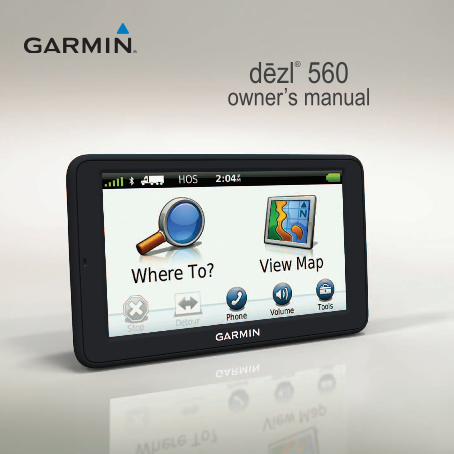
dēzl® 560owner’s manual
© 2012 Garmin Ltd. or its subsidiariesAll rights reserved. Except as expressly provided herein, no part of this manual may be reproduced, copied, transmitted, disseminated, downloaded or stored in any storage medium, for any purpose without the express prior written consent of Garmin. Garmin hereby grants permission to download a single copy of this manual onto a hard drive or other electronic storage medium to be viewed and to print one copy of this manual or of any revision hereto, provided that such electronic or printed copy of this manual must contain the complete text of this copyright notice and provided further that any unauthorized commercial distribution of this manual or any revision hereto is strictly prohibited.Information in this document is subject to change without notice. Garmin reserves the right to change or improve its products and to make changes in the content without obligation to notify any person or organization of such changes or improvements. Go to the Garmin Web site (www.garmin.com) for current updates and supplemental information concerning the use and operation of this and other Garmin products.Garmin®, the Garmin logo, and MapSource® are trademarks of Garmin Ltd. or its subsidiaries, registered in the USA and other countries. cityXplorer™, dēzl™, ecoRoute™, Garmin Lock™, myGarmin™, myGarmin Agent™, myTrends™, nüMaps Guarantee™, nüMaps Lifetime, nüRoute™, and trafficTrends™ are trademarks of Garmin Ltd. or its subsidiaries. These trademarks may not be used without the express permission of Garmin. The Bluetooth® word mark and logos are owned by the Bluetooth SIG, Inc., and any use of such name by Garmin is under license. Mac® is a trademark of Apple Computer, Inc., registered in the U.S. and other countries. microSD™ is a trademark of SD-3C, LLC. Windows® is a registered trademark of Microsoft Corporation in the United States and other countries.
dēzl 560 Owner’s Manual i
Table of Contents
Table of ContentsGetting Started .................... 1Mounting the Device .................. 1About myDashboard .................. 6Entering a Truck or RV Profile ... 7Acquiring Satellites .................... 7Device Overview........................ 8Adjusting the Screen Brightness 8Resetting the Device ................. 8Adjusting the Volume ................. 9Using the Main Menu................. 9Using the On-screen Buttons .. 10Using the On-screen Keyboard 10Transportation Modes ...............11Using a Backup Camera...........11Searching for a Location . 12Finding an Address .................. 12Using the Location Map ........... 12Finding a Location Using the
Map ....................................... 13Using a Breakdown Directory .. 13
Using Exit Services.................. 14Finding Trucking Points of
Interest .................................. 14Setting a Home Location ......... 14About Points of Interest ........... 15Finding Your Last Parking
Spot ....................................... 17Viewing a List of Recently
Found Locations ................... 17Favorites .................................. 17Entering Coordinates ............... 19Changing the Search Area ...... 19Planning a Trip .................. 20Scheduling a Trip ..................... 20Navigating a Saved Trip .......... 21Editing a Saved Trip ................ 21Setting a Simulated Location ... 21Simulating a Route .................. 21Navigation ......................... 22Map Features While
Navigating ............................. 22Using the Navigation Map ....... 23
ii dēzl 560 Owner’s Manual
Table of Contents
Viewing Trip Information ......... 24Viewing the Turn List .............. 25Viewing the Next Turn ............. 25Viewing the Junction View ....... 26Selecting a Route Calculation
Mode ..................................... 26Adding One Point to the Active
Route .................................... 26Taking a Detour ....................... 27Stopping the Route .................. 27About myTrends™ .................... 28Using the Pedestrian
Navigation Map ..................... 28Traffic ................................. 30Subscription Activation ............ 30Traffic Receiver ....................... 30Receiving Traffic Information ... 31About the Traffic Icon............... 31Traffic on Your Route ............... 32Viewing the Traffic Map ........... 32Searching for Traffic Delays .... 33Adding a Subscription.............. 33
About Offers and Advertisements ..................... 34
Using Trucking Features.. 35About IFTA Logging ................. 35About Hours of Service............ 38Using the Tools ................. 43Viewing Current Location
Information ............................ 43Using Help ............................... 43About ecoRoute™ ..................... 43Using the Picture Viewer ......... 47Using the World Clock ............ 48Using the Calculator ................ 48Capturing Screenshots ............ 48Using the Unit Converter ........ 48Hands-Free Phone Calls .. 50About Pairing the Devices ....... 50Receiving a Call ...................... 52Using the Device During a
Call ....................................... 52Dialing a Point of Interest ........ 53
dēzl 560 Owner’s Manual iii
Table of Contents
Dialing a Number ..................... 53Entering Your Phone Number .. 53Placing Calls Using Voice
Dial ........................................ 54Checking the Phone Status ..... 54Data Management ............. 55File Types ................................ 55About Memory Cards............... 55Transferring Files To Your
Computer ............................. 56Deleting Files .......................... 57Customizing the Device ... 58System Settings....................... 58Customizing the Main Menu .... 58Adding Truck or RV Profiles .... 60Automobile, Truck, and RV
Navigation Settings ............... 61Pedestrian Navigation
Settings ................................. 63Choosing Route Preferences .. 63Display Settings ....................... 66Language Settings................... 66
Viewing Map Information ........ 67Bluetooth Settings ................... 67Enabling Traffic ........................ 67Restoring Settings ................... 67Appendix ........................... 68Warning Icons .......................... 68Power Cables .......................... 69Caring for Your Device............. 70About Garmin Lock .................. 71Erasing User Data ................... 72Battery Information ................. 72Changing the Fuse in the
Vehicle Power Cable ............. 73Removing the Device, Cradle,
and Mount ............................. 74About nüMaps Lifetime™ ......... 75Device Models ......................... 75Purchasing Additional Maps .... 75Custom Points of Interest ........ 75Safety Cameras ....................... 76Purchasing Accessories .......... 77
iv dēzl 560 Owner’s Manual
Table of Contents
Contacting Garmin Product Support ................................. 77
Specifications .......................... 77Troubleshooting ....................... 78Index .................................. 80
dēzl 560 Owner’s Manual 1
Getting Started
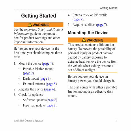
Getting Started WARNING
See the Important Safety and Product Information guide in the product box for product warnings and other important information.
Before you use your device for the first time, you should complete these tasks.
1. Mount the device (page 1):• Portable friction mount
(page 2).• Dash mount (page 3).• External antenna (page 5).
2. Register the device (page 6).3. Check for updates:
• Software updates (page 6).• Free map update (page 7).
4. Enter a truck or RV profile (page 7).
5. Acquire satellites (page 7).
Mounting the Device WARNING
This product contains a lithium-ion battery. To prevent the possibility of personal injury or product damage caused by battery exposure to extreme heat, remove the device from the vehicle when exiting or store it out of direct sunlight.
Before you use your device on battery power, you should charge it.
The dēzl comes with either a portable friction mount or an adhesive dash mount.
2 dēzl 560 Owner’s Manual
Getting Started
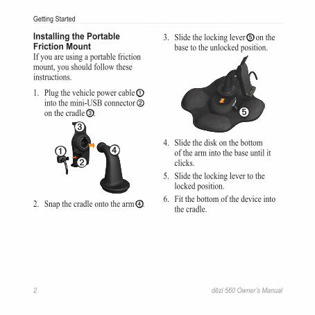
Installing the Portable Friction MountIf you are using a portable friction mount, you should follow these instructions.
1. Plug the vehicle power cable ➊ into the mini-USB connector ➋
on the cradle ➌.
➋➊
➌
➍
2. Snap the cradle onto the arm ➍.
3. Slide the locking lever ➎ on the base to the unlocked position.
➎
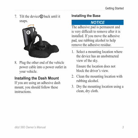
4. Slide the disk on the bottom of the arm into the base until it clicks.
5. Slide the locking lever to the locked position.
6. Fit the bottom of the device into the cradle.
dēzl 560 Owner’s Manual 3
Getting Started
7. Tilt the device ➏ back until it snaps.
➏
8. Plug the other end of the vehicle power cable into a power outlet in your vehicle.
Installing the Dash MountIf you are using an adhesive dash mount, you should follow these instructions.
Installing the Base
NOTICEThe adhesive pad is permanent and is very difficult to remove after it is installed. If you move the adhesive pad, use rubbing alcohol to help remove the adhesive residue.
1. Select a mounting location where the device has an unobstructed view of the sky.Ensure the location does not block the driver’s view.
2. Clean the mounting location with rubbing alcohol.
3. Dry the mounting location using a clean, dry cloth.
4 dēzl 560 Owner’s Manual
Getting Started
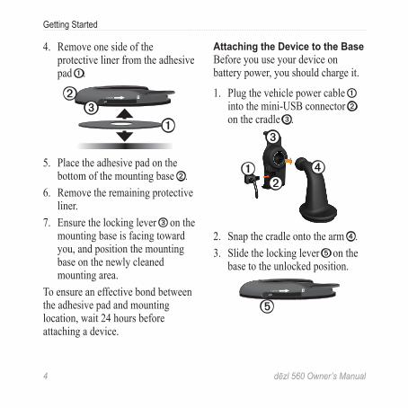
4. Remove one side of the protective liner from the adhesive pad ➊.
➊
LOCK
LOCK➋➌
5. Place the adhesive pad on the bottom of the mounting base ➋.
6. Remove the remaining protective liner.
7. Ensure the locking lever ➌ on the mounting base is facing toward you, and position the mounting base on the newly cleaned mounting area.
To ensure an effective bond between the adhesive pad and mounting location, wait 24 hours before attaching a device.
Attaching the Device to the BaseBefore you use your device on battery power, you should charge it.
1. Plug the vehicle power cable ➊ into the mini-USB connector ➋
on the cradle ➌.
➋➊
➌
➍
2. Snap the cradle onto the arm ➍.3. Slide the locking lever ➎ on the
base to the unlocked position.
LOCK
➎
dēzl 560 Owner’s Manual 5
Getting Started
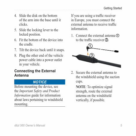
4. Slide the disk on the bottom of the arm into the base until it clicks.
5. Slide the locking lever to the locked position.
6. Fit the bottom of the device into the cradle.
7. Tilt the device back until it snaps.8. Plug the other end of the vehicle
power cable into a power outlet in your vehicle.
Connecting the External Antenna
NOTICEBefore mounting the device, see the Important Safety and Product Information guide for information about laws pertaining to windshield mounting.
If you are using a traffic receiver in Europe, you must connect the external antenna to receive traffic information.
1. Connect the external antenna ➊ to the traffic receiver ➋.
➊
➋
2. Secure the external antenna to the windshield using the suction cups.NOTE: To optimize signal strength, route the external antenna on the windshield vertically, if possible.
6 dēzl 560 Owner’s Manual
Getting Started
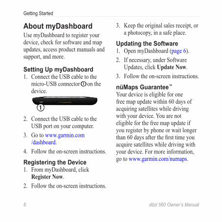
About myDashboardUse myDashboard to register your device, check for software and map updates, access product manuals and support, and more.
Setting Up myDashboard1. Connect the USB cable to the
micro-USB connector ➊ on the device.
➊2. Connect the USB cable to the
USB port on your computer.3. Go to www.garmin.com
/dashboard.4. Follow the on-screen instructions.
Registering the Device1. From myDashboard, click
Register Now.2. Follow the on-screen instructions.
3. Keep the original sales receipt, or a photocopy, in a safe place.
Updating the Software1. Open myDashboard (page 6).2. If necessary, under Software
Updates, click Update Now.3. Follow the on-screen instructions.
nüMaps Guarantee™
Your device is eligible for one free map update within 60 days of acquiring satellites while driving with your device. You are not eligible for the free map update if you register by phone or wait longer than 60 days after the first time you acquire satellites while driving with your device. For more information, go to www.garmin.com/numaps.
dēzl 560 Owner’s Manual 7
Getting Started
Updating Maps1. Open myDashboard (page 6).2. Register the device (page 6).3. If necessary, under Map Updates,
click Update Now.4. Follow the on-screen instructions.
Entering a Truck or RV Profile
WARNINGEntering your vehicle profile does not guarantee that your vehicle’s characteristics will be accounted for in all route suggestions. It is your responsibility to account for your vehicle’s height, length, weight, and other relevant restrictions when driving. Always defer to all posted road signs and road conditions when making driving decisions.
Before you can operate in Truck or RV mode, you must enter your truck or RV profile.
Truck transportation mode is selected the first time you turn on your device. You can select Switch Mode to enter an RV profile.
1. When the warning screen appears, touch Agree.
2. Touch Yes to enter your truck profile.
3. Follow the on-screen instructions.
Acquiring SatellitesBefore you can navigate with your device, you must acquire satellites.
For more information about GPS, go to www.garmin.com/aboutGPS.
8 dēzl 560 Owner’s Manual
Getting Started
1. Turn on your device.2. If necessary, go outdoors to
an open area, away from tall buildings and trees.
Acquiring satellites can take a few minutes. When the device has acquired satellite signals, the signal strength bars on the main menu are green . When it loses satellite signals, the bars turn red or clear
.
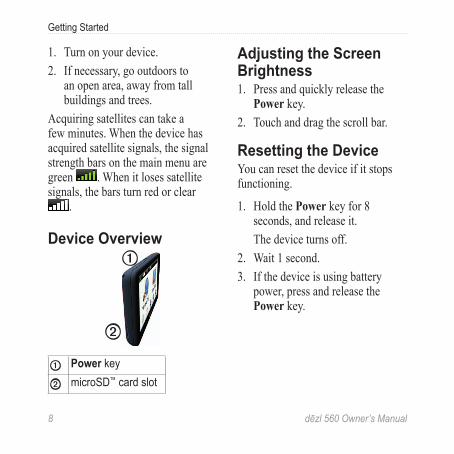
Device Overview➊
➋
➊ Power key
➋ microSD™ card slot
Adjusting the Screen Brightness1. Press and quickly release the
Power key.2. Touch and drag the scroll bar.
Resetting the DeviceYou can reset the device if it stops functioning.
1. Hold the Power key for 8 seconds, and release it.The device turns off.
2. Wait 1 second.3. If the device is using battery
power, press and release the Power key.
dēzl 560 Owner’s Manual 9
Getting Started
Adjusting the Volume1. Touch Volume. 2. Select an option:
• Adjust the slider left to right to adjust the volume.
• Touch to mute all audio.
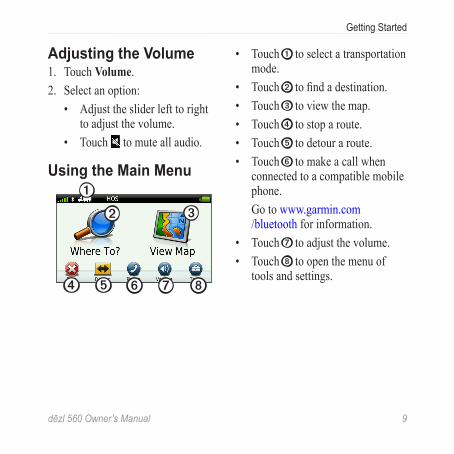
Using the Main Menu➊
➋ ➌
➍ ➐ ➑➎ ➏
• Touch ➊ to select a transportation mode.
• Touch ➋ to find a destination.• Touch ➌ to view the map.• Touch ➍ to stop a route.• Touch ➎ to detour a route.• Touch ➏ to make a call when
connected to a compatible mobile phone.Go to www.garmin.com/bluetooth for information.
• Touch ➐ to adjust the volume.• Touch ➑ to open the menu of
tools and settings.
10 dēzl 560 Owner’s Manual
Getting Started
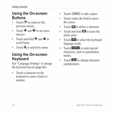
Using the On-screen Buttons• Touch to return to the
previous screen.• Touch and to see more
choices. • Touch and hold and to
scroll faster.• Touch to search by name.
Using the On-screen KeyboardSee “Language Settings” to change the keyboard layout (page 66).
• Touch a character on the keyboard to enter a letter or number.
• Touch to add a space.• Touch within the field to move
the cursor.• Touch to delete a character. • Touch and hold to erase the
entire entry.• Touch to select the keyboard
language mode. • Touch to enter special
characters, such as punctuation marks.
• Touch to change character capitalization.
dēzl 560 Owner’s Manual 11
Getting Started
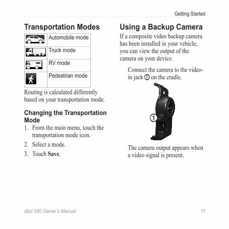
Transportation ModesAutomobile mode
Truck mode
RV mode
Pedestrian mode
Routing is calculated differently based on your transportation mode.
Changing the Transportation Mode1. From the main menu, touch the
transportation mode icon.2. Select a mode.3. Touch Save.
Using a Backup CameraIf a composite video backup camera has been installed in your vehicle, you can view the output of the camera on your device.
Connect the camera to the video-in jack ➊ on the cradle.
➊
The camera output appears when a video signal is present.
12 dēzl 560 Owner’s Manual
Searching for a Location
Searching for a Location
Finding an AddressNOTE: Depending on the version of the built-in map data on your device, the button names and the order of steps could be different from the steps below.
1. From the main menu, touch Where To? > Address.
2. If necessary, change the state, the country, or the province.
3. Touch Search All.TIP: You can touch Spell City to search by city or postal code. Not all map data provides postal code searching.
4. Enter the number for the address, and touch Done.
5. Enter the street name, and touch Done.
6. If necessary, select the street.7. If necessary, select the address.
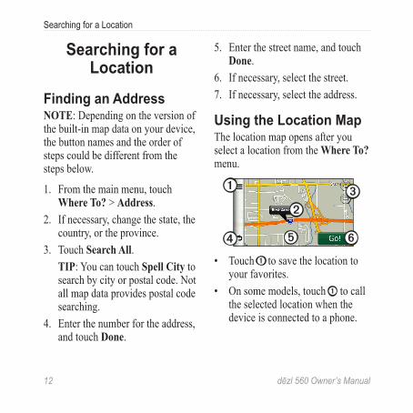
Using the Location MapThe location map opens after you select a location from the Where To? menu.
➋
➊
➍ ➎ ➏
➌
• Touch ➊ to save the location to your favorites.
• On some models, touch ➊ to call the selected location when the device is connected to a phone.
dēzl 560 Owner’s Manual 13
Searching for a Location
• Touch the information balloon ➋
to view more information for the location.
• Touch ➌ to zoom in and out.• Touch ➍ to return to the previous
page. • Touch and drag ➎ to view
different parts of the map. • Touch ➏ to create a turn-by-turn
route to this location.
Finding a Location Using the Map1. From the main menu, touch
Where To? > Browse Map. 2. Select a location. An information balloon appears
for the location.
Viewing a Route on the Map1. From the location map, touch the
information balloon.2. Touch the route information box.
Using a Breakdown DirectoryThe breakdown directory lists businesses for the trucking industry, such as truck repair and tire sales. The breakdown directory is available in some areas.
Data for the breakdown directory is updated periodically. To purchase updates, go to http://buy.garmin.com.
1. From the main menu, touch Where To?.
2. Select an option:NOTE: This menu option is determined by the breakdown directory provider for the device. • Touch TruckDown.
14 dēzl 560 Owner’s Manual
Searching for a Location
• Touch NTTS.2. Select a category.3. If necessary, select a subcategory.4. Select a destination.
Using Exit ServicesYou can find services such as fuel, lodging, and truck stops at upcoming highway exits. The device displays available services based on the usage mode. Exit service information is available only on controlled-access roads, such as interstates or motorways.
NOTE: Exit services are not available for Pedestrian mode.
1. While navigating a route, from the main menu, touch Where To? > Exit Services.
2. Select an option.
Finding Trucking Points of InterestThe detailed maps loaded in your device contain trucking points of interest, such as truck stops, rest areas, and weigh stations.
1. From the main menu, touch Where To? > Points of Interest > Trucking.
2. Select a category.3. If necessary, select a subcategory.4. Select a destination.
Setting a Home LocationYou can set your home location for the location you return to most often.
1. From the main menu, touch Where To? > Go Home.
2. Select Enter My Address, Use My Current Location, or Recently Found.
dēzl 560 Owner’s Manual 15
Searching for a Location
Going HomeBefore you can navigate to home, you must set a home location.
From the main menu, touch Where To? > Go Home.
Resetting Your Home Location1. From the main menu, touch
Where To? > > Set Home Location.
2. Select an option.
Editing Your Home Location Information1. From the main menu, touch
Where To? > Favorites > Home.2. Touch > Edit.3. Enter your changes.4. Touch Done.
About Points of InterestThe detailed maps loaded in your device contain points of interest, such as restaurants, hotels, and auto services. You can use the Points of Interest category to browse for nearby businesses and attractions.
Finding a Location by Spelling the Name1. From the main menu, touch
Where To? > Points of Interest > Spell Name.
2. Enter all or part of the name, and touch Done.
3. Select a destination.
Finding a Point of Interest by Category1. From the main menu, touch
Where To? > Points of Interest.2. Select a category.3. If necessary, select a subcategory.
16 dēzl 560 Owner’s Manual
Searching for a Location
4. Select a destination.
Using Photo NavigationYou can upload pictures onto your device or memory card that include location information and create routes to the pictured locations.
1. Connect your device to your computer (page 6).
2. Go to http://connect.garmin.com/photos.
3. Follow the instructions to select and load pictures to your device.
4. Disconnect the device from the computer.
5. Turn on the device.6. From the main menu, touch
Where To? > Favorites > Photos. A list of pictures with location information appears.
7. Select a picture.
Removing an Incorrect Point of InterestWhen your search results contain an outdated or incorrect point of interest, you can remove the location from future searches.
1. From the location map, touch the information balloon.
2. Touch > Report Error > Yes. The location is removed from future searches.
Reporting an Incorrect Point of InterestBefore you can report an incorrect point of interest, you must remove it from future searches (page 16).
1. Connect your device to your computer (page 6).
2. Go to www.garmin.com/dashboard.
dēzl 560 Owner’s Manual 17
Searching for a Location
3. Under myDashboard Preferences, click Change Preferences > Yes.
myDashboard collects the data from your device.
Rating a Point of InterestWhen available, you can view and change the star rating for a point of interest.
1. From the location map, touch the information balloon.If available, the star ratings appear under the address of the location.
2. Touch the stars to rate the point of interest.
The star rating updates on your device.
Finding Your Last Parking Spot
From the main menu, touch Where To? > Parking > Last Spot.
Viewing a List of Recently Found LocationsYour device stores the last 50 locations you have found.
From the main menu, touch Where To? > Recently Found.
Clearing the List of Recently Found Locations
From the main menu, touch Where To? > Recently Found >
> Clear > Yes.
FavoritesYou can save locations in your favorites so you can quickly find
18 dēzl 560 Owner’s Manual
Searching for a Location
them and create routes to them. Your home location is also stored in favorites.
Saving Your Current Location to Favorites1. From the map, touch the vehicle
icon. 2. Touch Save.3. Enter a name.The location is saved in Favorites.
Saving Locations to Favorites1. Search for the location (page 12).2. From the Go! page, touch >
Save > OK.
Finding Favorites1. From the main menu, touch
Where To? > Favorites.2. If necessary, select a category.3. Select a saved location.
Editing Favorites1. From the main menu, touch
Where To? > Favorites.2. Select a category.3. Select a favorite.4. Touch the information balloon.5. Touch > Edit.6. Select an option:
• Touch Name.• Touch Phone Number.• Touch Categories to enter
a category name for the favorite.NOTE: Categories appear if the device contains at least 12 favorites.
• Touch Assign Photo to save a photo with the favorite.
• Touch Change Map Symbol to change the symbol used to mark the favorite on a map.
dēzl 560 Owner’s Manual 19
Searching for a Location
7. Edit the information.8. Touch Done.
Deleting Favorites1. From the main menu, touch
Where To? > Favorites.2. If necessary, select a category.3. Select a favorite.4. Touch > Delete > Yes.
Entering CoordinatesIf you know the geographic coordinates of your destination, you can use your device to navigate to the destination using the latitude and longitude coordinates. This can be especially helpful when geocaching.
1. From the main menu, touch Where To? > Coordinates.
2. Touch a field to enter the latitude and longitude data.
3. Touch View on Map.
Changing the Map Coordinate Format1. From the Home Screen, touch
Where To? > Coordinates > Format.
2. Select a format.
Changing the Search AreaThe device automatically searches for places near your present location. You can also search for a location near a different city, near a recent destination, or near a favorite destination.
1. From the main menu, touch Where To? > > Near.
2. Select an option.3. Touch Save.
20 dēzl 560 Owner’s Manual
Planning a Trip
Planning a TripYou can use Trip Planner to create and save a trip with multiple destinations.
1. From the main menu, touch Where To? > Trip Planner.
2. Touch .3. Touch Select Start Location.4. Search for a location (page 12).5. Touch Select.6. Touch to add additional
locations.7. Touch Next.8. Enter a name, and touch Done.9. Touch Map to view the trip on
the map.
Scheduling a TripThe trip planner allows you to set a departure time and trip duration.
1. From the main menu, touch Where To? > Trip Planner.
2. Select a trip.3. Select a location.4. Touch Departure Time or
Arrival Time.5. Select a date and time.6. Touch Save.7. Touch Duration.8. Select the amount of time you
will spend at the location.9. Touch Save.10. If necessary, repeat steps 3–9 for
each location.
dēzl 560 Owner’s Manual 21
Planning a Trip
Navigating a Saved Trip1. From the main menu, touch
Where To? > Trip Planner.2. Select a saved trip.3. Touch Go!.
Editing a Saved Trip1. From the main menu, touch
Where To? > Trip Planner.2. Select a saved trip.3. Touch .4. Select an option:
• Touch Rename Trip to edit the trip name.
• Touch Edit Destinations to add or delete locations.
• Touch Delete Trip.• Touch Optimize Order to
arrange your trip locations in the most-efficient order.
Setting a Simulated Location1. From the main menu, touch Tools
> Settings > System > GPS Simulator > On.
2. From the main menu, touch Where To? > Browse Map.
3. Touch an area on the map.4. Touch > Set Location.
Simulating a Route1. From the main menu, touch Tools
> Settings > System > GPS Simulator > On.
2. Search for a location (page 12).3. Touch Go! > Yes.
22 dēzl 560 Owner’s Manual
Navigation
Navigation
Map Features While Navigating
NOTICEThe speed limit icon feature is for information only and does not replace the driver’s responsibility to abide by all posted speed limit signs and to use safe driving judgment at all times. Garmin will not be responsible for any traffic fines or citations that you may receive for failing to follow all applicable traffic laws and signs.
Your route is marked with a magenta line. A checkered flag marks your destination.
As you travel, your device guides you to your destination with voice
prompts, arrows on the map, and directions at the top of the map. If you depart from the original route, your device recalculates the route and provides new directions.
An icon displaying the current speed limit may appear as you travel on major roadways.
Truck speed limits may appear for Truck mode based on truck configuration data and applicable laws for the state or province.
When you are driving in Truck mode or RV mode, a tone may sound and may appear, indicating that truck suitability for this roadway is unknown. Always obey posted signs and regulations.
NOTE: Truck speed limits are not available for all areas.
dēzl 560 Owner’s Manual 23
Navigation
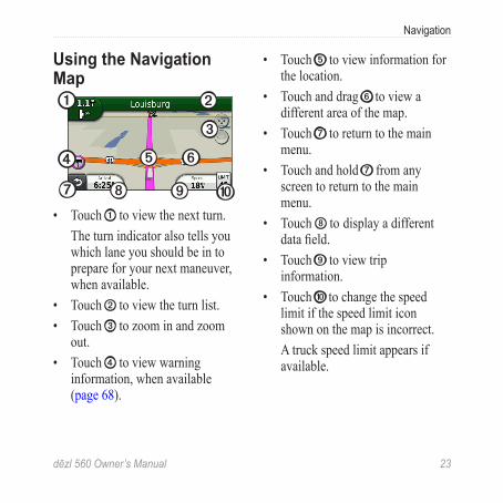
Using the Navigation Map➊ ➋
➌
➍ ➎ ➏
➐ ➑ ➒ ➓• Touch ➊ to view the next turn.
The turn indicator also tells you which lane you should be in to prepare for your next maneuver, when available.
• Touch ➋ to view the turn list.• Touch ➌ to zoom in and zoom
out.• Touch ➍ to view warning
information, when available (page 68).
• Touch ➎ to view information for the location.
• Touch and drag ➏ to view a different area of the map.
• Touch ➐ to return to the main menu.
• Touch and hold ➐ from any screen to return to the main menu.
• Touch ➑ to display a different data field.
• Touch ➒ to view trip information.
• Touch ➓ to change the speed limit if the speed limit icon shown on the map is incorrect.A truck speed limit appears if available.
24 dēzl 560 Owner’s Manual
Navigation
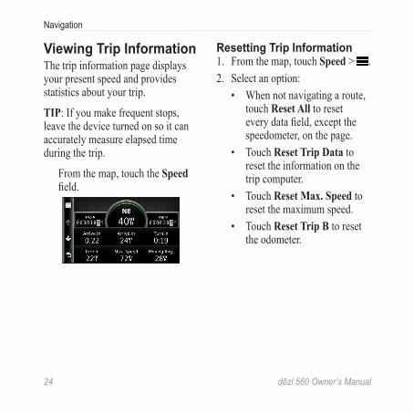
Viewing Trip Information The trip information page displays your present speed and provides statistics about your trip.
TIP: If you make frequent stops, leave the device turned on so it can accurately measure elapsed time during the trip.
From the map, touch the Speed field.
Resetting Trip Information1. From the map, touch Speed > .2. Select an option:
• When not navigating a route, touch Reset All to reset every data field, except the speedometer, on the page.
• Touch Reset Trip Data to reset the information on the trip computer.
• Touch Reset Max. Speed to reset the maximum speed.
• Touch Reset Trip B to reset the odometer.
dēzl 560 Owner’s Manual 25
Navigation
Viewing the Turn List When you are navigating a route, you can view all of the turns for your entire route and the distance between turns.
1. Touch the text bar on the top of the map.
2. Select an option:• Select a turn on the list to
view the next turn. • Touch > Show Map to
view the entire route on the map.
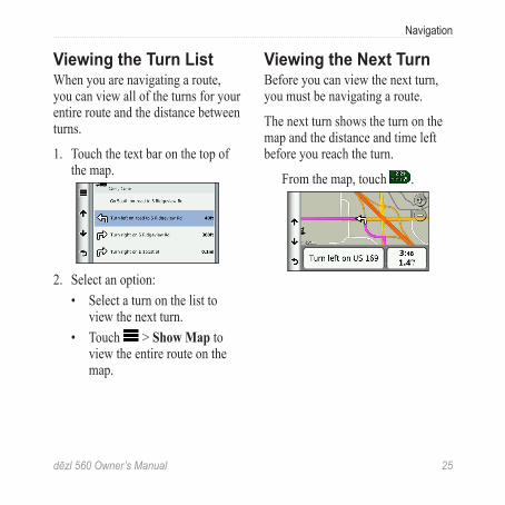
Viewing the Next TurnBefore you can view the next turn, you must be navigating a route.
The next turn shows the turn on the map and the distance and time left before you reach the turn.
From the map, touch .
26 dēzl 560 Owner’s Manual
Navigation
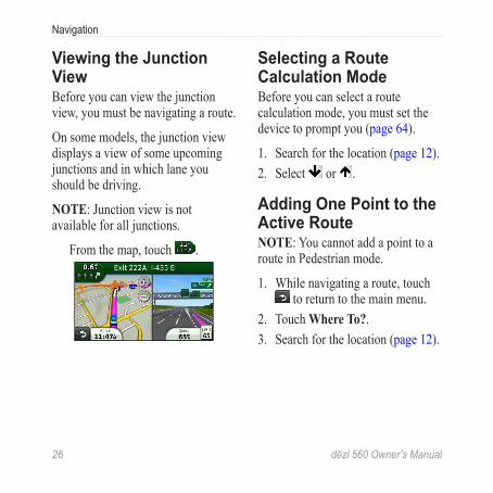
Viewing the Junction ViewBefore you can view the junction view, you must be navigating a route.
On some models, the junction view displays a view of some upcoming junctions and in which lane you should be driving.
NOTE: Junction view is not available for all junctions.
From the map, touch .
Selecting a Route Calculation ModeBefore you can select a route calculation mode, you must set the device to prompt you (page 64).
1. Search for the location (page 12).2. Select or .
Adding One Point to the Active RouteNOTE: You cannot add a point to a route in Pedestrian mode.
1. While navigating a route, touch to return to the main menu.
2. Touch Where To?.3. Search for the location (page 12).
dēzl 560 Owner’s Manual 27
Navigation
4. Touch Go!.5. Touch Add to Active Route.6. Touch and drag the locations to
order them, and touch Done.
Taking a DetourWhile navigating a route, you can use detours to avoid obstacles ahead of you, such as construction zones. If Advanced Detours is enabled, you can select a specific distance or road to avoid (page 65).
1. While navigating a route, touch to return to the main menu.
2. Touch Detour.3. If necessary, select an option:
• To avoid the next 1/2 mile, select Next 1/2 Mile on Route.
• To avoid the next 2 miles, select Next 2 Miles on Route.
• To avoid the next 5 miles, select Next 5 Miles on Route.
• To select a specific road to avoid, select Detour by Road(s) on Route.
If the route you are currently taking is the only reasonable option, the device might not calculate a detour.
Stopping the RouteWhile navigating a route, touch
> Stop.
28 dēzl 560 Owner’s Manual
Navigation
About myTrends™
After you save your frequently-visited destinations as favorites, myTrends senses when you drive to them. After recording your driving patterns, myTrends displays the route and the estimated time of arrival in the navigation bar on the map.
Setting up myTrends1. From the main menu, touch Tools
> Settings > Navigation.2. Select an option: Automobile,
Truck, or RV.3. Touch nüRoute > myTrends >
Enabled.4. Save a destination as a favorite
(page 17).5. With the device on, drive to the
favorite at least three times.
6. When myTrends information appears in the navigation bar, touch it to view route information.
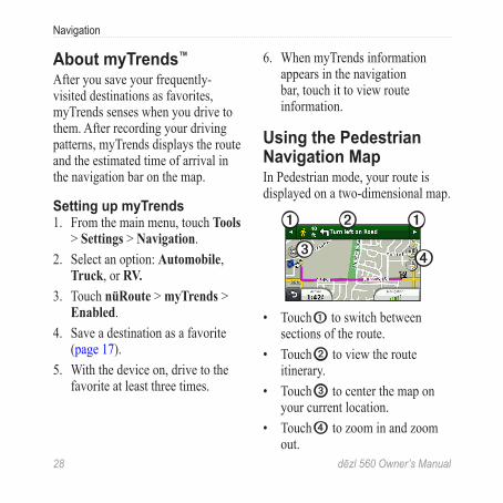
Using the Pedestrian Navigation MapIn Pedestrian mode, your route is displayed on a two-dimensional map.
➋➊ ➊
➌ ➍
• Touch ➊ to switch between sections of the route.
• Touch ➋ to view the route itinerary.
• Touch ➌ to center the map on your current location.
• Touch ➍ to zoom in and zoom out.
dēzl 560 Owner’s Manual 29
Navigation
Public Transit OptionsIf you have cityXplorer maps installed, the device calculates a route that uses a combination of public transit options, such as riding a bus or subway, and walking.
cityXplorer maps are not included with the device. See http://my.garmin.com to purchase cityXplorer maps.
The yellow icons indicate the navigation method used in each section of the route. For example, when you see , board a bus at that point in the route.
The black dots on the map are public transit stops along your route.
NOTE: You can limit the distance spent walking during a pedestrian route (page 63).
30 dēzl 560 Owner’s Manual
Traffic
TrafficNOTICE
Garmin is not responsible for the accuracy or timeliness of the traffic information. Traffic information is not available in all areas.
This device can receive FM Traffic Message Channel (TMC) traffic content, which provides information on nearby traffic incidents and construction. Some models are packaged with a FM TMC traffic receiver, built into the vehicle power cable, and have a lifetime traffic subscription.
For information about traffic receivers and coverage areas, go to www.garmin.com/traffic.
Subscription ActivationYou do not need to activate the subscription included with your FM traffic receiver. The subscription activates automatically after your device acquires satellite signals while receiving traffic signals from the pay service provider.
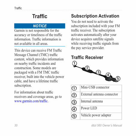
Traffic Receiver➊
➋➌ ➍
➎
➊ Mini-USB connector
➋ External antenna connector
➌ Internal antenna
➍ Power LED
➎ Vehicle power adapter
dēzl 560 Owner’s Manual 31
Traffic
Receiving Traffic InformationWhen the receiver is within a traffic coverage area, your device will begin displaying traffic information.
The traffic receiver and the device must be in data range of an FM station transmitting traffic information.
1. Connect the traffic receiver to an external power source.
2. Connect the traffic receiver to the device.
NOTE: Heated (metallized) windshields could degrade the performance of the traffic receiver.
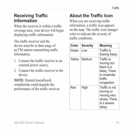
About the Traffic IconWhen you are receiving traffic information, a traffic icon appears on the map. The traffic icon changes color to indicate the severity of traffic conditions.
Color Severity MeaningGreen Low Traffic is
flowing freely.Yellow Medium Traffic is
moving but there is a delay. There is moderate traffic congestion.
Red High Traffic is not moving or moving very slowly. There is a severe delay.
32 dēzl 560 Owner’s Manual
Traffic
Traffic on Your Route CAUTION
If you choose to recalculate your route when you are navigating in Truck mode, the recalculated route might include roads that have not been verified for truck accessibility. You should use caution and good judgment and obey all posted signs and regulations.
When calculating your route, the device examines the current traffic and automatically optimizes the route for the shortest time. If a severe traffic delay occurs on your route while you are navigating, the device automatically recalculates the route. You might still be routed through traffic if no better alternative routes exist.
Manually Avoiding Traffic on Your Route1. From the map, touch .2. Touch Traffic On Route. 3. If necessary, touch the arrows to
view other traffic delays on your route.
4. Touch > Avoid.
Viewing the Traffic MapThe traffic map shows color-coded traffic flow and delays on nearby roads.
1. From the map, touch .2. Touch Traffic Map to view the
traffic incidents on a map.
dēzl 560 Owner’s Manual 33
Traffic
Searching for Traffic Delays1. From the map page, touch .2. Touch Traffic Search to view a
list of roads with traffic delays. 3. Touch an item in the list to view
delays on the road.4. If there is more than one delay,
touch the arrows to view additional delays.
Adding a SubscriptionYou can purchase traffic subscriptions for other regions or countries.
1. From the main menu, touch Tools > Settings > Traffic.
2. If necessary, touch Subscriptions.
3. Touch .4. Write down the FM traffic
receiver unit ID. 5. Go to www.garmin.com/fmtraffic
to purchase a subscription and get a 25-character code.
6. Touch Next on the device.7. Enter the code.8. Touch Done. The traffic subscription code cannot be reused. You must obtain a new code each time you renew your service. If you own multiple FM traffic receivers, you must obtain a new code for each receiver.
34 dēzl 560 Owner’s Manual
Traffic
About Offers and AdvertisementsIf your device package includes a traffic receiver, you will receive location-relevant offers and coupons. Ad-based traffic information is only available in North America.
The traffic receiver must be connected to external power and you must be in a coverage area to receive ad-based traffic information.
See our privacy statement at www.garmin.com/products/privacy for important privacy information.
NOTE: This feature is not available in all areas.
Viewing Offers CAUTION
Do not attempt to write down the coupon codes while driving.
1. Select an offer that appears on the screen to search for the nearest location related to that offer.
2. If the offer includes an icon, touch the icon on the location map to receive a coupon code.
3. Write down this code, and present it when you arrive at the location.
Viewing an Offer List From the main menu, touch Tools
> Offers.
Disabling Traffic and OffersBefore you can disable offers, you must disable traffic.
From the main menu, touch Tools > Settings > Traffic > Disabled.
dēzl 560 Owner’s Manual 35
Using Trucking Features
Using Trucking Features
About IFTA LoggingYou can use IFTA Logging to archive data needed for International Fuel Tax Agreement documentation, such as fuel-purchase data and miles driven.
Before you can use IFTA Logging, you must be in Truck mode (page 11).
NOTE: This feature is not available in all areas.
Entering Fuel Data1. From the main menu, touch Tools
> IFTA Logging > At the Pump.2. Enter the fuel price per gallon.3. Touch the Fuel Used field.4. Enter the amount of fuel
purchased.5. If necessary, select an option:
• To record the amount in liters, touch Gallons > Liters > Save.
• To record the amount in gallons, touch Liters > Gallons > Save.
6. If necessary, select the Tax Included check box.
36 dēzl 560 Owner’s Manual
Using Trucking Features
7. Touch Next.8. Select the vendor from whom
you purchased the fuel.9. Select the purchaser of the fuel.10. Touch Save.
Using Fuel LogsBefore you can use IFTA Logging, you must be in Truck mode (page 11).
NOTE: This feature is not available in all areas.
1. From the main menu, touch Tools > IFTA Logging > Fuel Logs.
2. If necessary, select a truck.3. If necessary, select a quarter.4. Select a log.
5. Select an option:• Touch a field to edit the
information.• Touch > Yes to delete the
log.
Viewing and Exporting a Jurisdiction SummaryThe jurisdiction summary lists data for each state or province in which your vehicle has operated during each quarter. The jurisdiction summary is available in some areas.
Before you can use IFTA Logging, you must be in Truck mode (page 11).
NOTE: This feature is not available in all areas.
dēzl 560 Owner’s Manual 37
Using Trucking Features
1. From the main menu, touch Tools > IFTA Logging > Jurisdiction Summary.
2. If necessary, select a truck.3. If necessary, select a quarter.4. To export a jurisdiction summary,
touch > Export > OK.The device exports the summary to a CSV file and stores it in the Reports folder in the device memory.
Using Trip ReportsBefore you can use IFTA Logging, you must be in Truck mode (page 11).
NOTE: This feature is not available in all areas.
1. From the main menu, touch Tools > IFTA Logging > Trip Reports.
2. If necessary, select a truck.3. If necessary, select a quarter.4. Select a report.5. Select an option:
• Touch > Delete, and touch the check box to delete a report.
• Touch > Combine, and touch the check boxes to combine reports.
• Touch > Export > OK.The device exports the report to a CSV file and stores it in the Reports folder in the device memory.
38 dēzl 560 Owner’s Manual
Using Trucking Features
Viewing Exported Jurisdiction Summaries and Trip Reports
NOTICEIf you do not know the purpose of a file, do not delete it. Your device memory contains important system files that should not be deleted.
1. Connect the device to your computer (page 6).
2. Open the “Garmin” drive or volume, and open the Reports folder.
3. Open the IFTA folder.4. Open the CSV file.
About Hours of ServiceNOTICE
Although this device is enabled to record hours-of-service information, this device is NOT an approved substitute for paper logbook recording requirements under Federal Motor Carrier Safety Administration regulations. Drivers should comply with all applicable federal and state paper logbook requirements.
You can use Hours of Service to record your working hours, which will help you comply with safety regulations.
Before you can use Hours of Service, you must be in Truck mode (page 11), and you must create a driver profile (page 40).
NOTE: This feature is not available in all areas.
dēzl 560 Owner’s Manual 39
Using Trucking Features
Recording Your Duty Status1. From the main menu, touch Tools
> Hours of Service.2. Select a driver > Duty Status.3. Select an option:
• Touch Off Duty to record the time you are off duty.
• Touch Sleeper to record the time you are resting in a sleeper berth.
• Touch Driving to record the time you are driving a commercial motor vehicle in operation.
• Touch On Duty to record the time you are on duty, but not driving a commercial motor vehicle.
4. Touch Save.
Using Driving LogsBefore you can use Hours of Service, you must be in Truck mode (page 11), and you must create a driver profile (page 40).
NOTE: This feature is not available in all areas.
1. From the main menu, touch Tools > Hours of Service.
2. Select a driver > View Log.3. Select an option:
• Touch the date field, and touch a different date to view.
• Touch a status bar to view status details.
• Touch the grid, and touch a field to edit.
• Touch to view violation information.
40 dēzl 560 Owner’s Manual
Using Trucking Features
About DriversMultiple drivers can use the same device to track hours of service.
Before you can use Hours of Service, you must be in Truck mode (page 11).
If you work for more than one carrier in a 24-hour period, you must record each carrier. You must record the time zone of your home terminal even if you cross other time zones.
NOTE: This feature is not available in all areas.
Adding Drivers1. From the main menu, touch Tools
> Hours of Service > .2. Follow the on-screen instructions.
Managing Driver Information1. From the main menu, touch Tools
> Hours of Service.2. Select a driver > Driver Info.3. Select an option:
• Touch a field to edit the information.
• Touch > Delete Driver > Yes to delete the driver.
Adding ShipmentsBefore you can use Hours of Service, you must be in Truck mode (page 11), and you must create a driver profile (page 40).
NOTE: This feature is not available in all areas.
dēzl 560 Owner’s Manual 41
Using Trucking Features
1. From the main menu, touch Tools > Hours of Service.
2. Select a driver > Manage Shipments > .
3. Touch Reference Number, enter the reference information, and touch Done.TIP: The reference number is the shipping document number, or the name of the company and the group you are transporting.
4. If necessary, touch Start Day, and touch the date service begins.
5. If necessary, touch End Day, and touch the date service ends.
6. Touch Save.
Managing ShipmentsBefore you can use Hours of Service, you must be in Truck mode (page 11), and you must create a driver profile (page 40).
NOTE: This feature is not available in all areas.
1. From the main menu, touch Tools > Hours of Service.
2. Select a driver > Manage Shipments.
3. Select a shipment.4. Select an option:
• Touch a field to edit the information.
• Touch > Delete Shipment > OK to delete the shipment.
42 dēzl 560 Owner’s Manual
Using Trucking Features
Exporting Driving LogsBefore you can use Hours of Service, you must be in Truck mode (page 11), and you must create a driver profile (page 40).
NOTE: This feature is not available in all areas.
1. From the main menu, touch Tools > Hours of Service.
2. Select a driver > Export Log.3. If necessary, enter your tractor
number, tractor VIN, and trailer number.
4. If necessary, select a log to export.
5. If necessary, select the location to export the log.
The device exports the log to a CSV file and stores it in the Reports folder in the device memory or on the memory card.
Viewing Exported Driving Logs
NOTICEIf you do not know the purpose of a file, do not delete it. Your device memory contains important system files that should not be deleted.
1. Connect the device to your computer (page 6).
2. Select an option: • To view the logs on your
device, open the “Garmin” drive or volume, and open the Reports folder.
• To view the logs on your memory card, open the drive or volume for the memory card, and open the Garmin folder.
3. Open the HOSExports folder.4. Open the CSV file.
dēzl 560 Owner’s Manual 43
Using the Tools
Using the Tools
Viewing Current Location InformationUse the Where Am I? page to view information about your current location. This feature is helpful if you need to tell emergency personnel your location.
From the main menu, touch Tools > Where Am I?.
Finding Nearby Services1. From the main menu, touch Tools
> Where Am I?2. Touch Hospitals, Police
Stations, or Fuel to view the nearest locations in that category.
Using Help From the main menu, touch Tools
> Help to view information about using the device.
Searching Help Topics From the main menu, touch Tools
> Help > .
About ecoRoute™
The ecoRoute feature calculates your vehicle fuel economy, carbon footprint, and the fuel price of navigating to a destination, and offers tools for improving fuel efficiency.
The data provided by the ecoRoute feature are estimates only. The data is not actually read from your vehicle. To receive more-accurate fuel reports for your specific vehicle and driving habits, calibrate the fuel economy (page 44).
44 dēzl 560 Owner’s Manual
Using the Tools
NOTE: ecoRoute is available only for Automobile mode.
Using ecoRoute1. From the main menu, select
Tools > ecoRoute.2. If prompted, enter fuel and
mileage information.The first time you use the ecoRoute features, you must enter vehicle information.
Calibrating the Fuel EconomyCalibrate the fuel economy to receive more-accurate fuel reports for your specific vehicle and driving habits. You should calibrate when you fill up your fuel tank.
1. From the main menu, select Tools > ecoRoute > At the Pump.
2. Enter the current fuel price.
3. Enter how much fuel your vehicle has used since the last fill up.
4. Enter the distance you have traveled since the last fill up.
5. Select Next. The device calculates the average vehicle fuel economy.
About the ecoChallengeThe ecoChallenge helps you maximize your fuel economy by scoring your driving habits. The higher your ecoChallenge scores, the more fuel you have saved. The ecoChallenge collects data and calculates a score whenever your device is moving and in Automobile transportation mode.
dēzl 560 Owner’s Manual 45
Using the Tools
Viewing Your ecoChallenge ScoresFrom the main menu, select Tools > ecoRoute > ecoChallenge.
About the ecoChallenge ScoreThe leaf color on the ecoChallenge icon changes depending on your performance in the challenge.
Overall—displays an average of the speed, acceleration, and braking score.
Speed—displays your score for driving at your vehicle’s optimal speed for conserving fuel (45-60 mph for most vehicles).
Acceleration—displays your score for smooth and gradual acceleration. You lose points for rapid acceleration.
Braking—displays your score for smooth and gradual braking. You lose points for hard braking.
Removing the ecoChallenge Score From the Map
From the map, select > > Settings > Hide.
Resetting the ecoChallengeFrom the map, select > > Reset.
Viewing Fuel Economy Information1. From the main menu, select Tools
> ecoRoute > Fuel Economy.2. Select a section of the graph to
zoom in.
46 dēzl 560 Owner’s Manual
Using the Tools
Adjusting the Vehicle Profile1. From the main menu, touch Tools
> ecoRoute > Vehicle Profile.2. Select an option to manually
adjust your fuel settings.• Fuel Type• City Fuel Economy• Hwy. Fuel Economy• Fuel Price
TIP: For best results, calibrate your fuel economy (page 44) instead of adjusting the city and highway fuel efficiency.
About the Mileage ReportMileage reports provide the distance, the time, the average fuel economy, and the fuel cost of navigating to a destination.
A mileage report is created for every route that you drive. If you stop a route on your device, a mileage report is created for the distance you traveled.
Viewing a Mileage ReportYou can view saved mileage reports on your device. You can also access mileage reports in the Reports folder on your device drive/volume (page 56).
1. From the main menu, touch Tools > ecoRoute > Mileage Report.
2. Select a report.
Viewing Driving TipsFrom the main menu, touch Tools > ecoRoute > Tips.
dēzl 560 Owner’s Manual 47
Using the Tools
Resetting ecoRoute Data1. From the main menu, touch Tools
> ecoRoute.2. Select a category.3. Touch > Reset.
Using the Picture ViewerYou can view pictures that you have stored in your device or on a memory card. See page 55 for more information about loading pictures on the device.
From the main menu, touch Tools > Picture Viewer.• Touch the arrows to scroll
through the images. • Touch a picture to view a
larger image of it.
• Touch to view a slide show of the pictures.
• Touch the screen to stop the slide show.
Setting a Picture as Wallpaper1. From the main menu, touch Tools
> Picture Viewer.2. Select a picture.3. Touch > Set as Wallpaper.4. Use the on-screen buttons to
adjust the wallpaper.5. Touch Save.
Deleting Pictures1. From the main menu, touch Tools
> Picture Viewer. 2. Select a picture.3. Touch > Delete > Yes.
48 dēzl 560 Owner’s Manual
Using the Tools
Using the World Clock 1. From the main menu, touch Tools
> World Clock.2. Touch a city name. 3. Enter a new city name4. Touch Done. 5. If necessary, select a city.
Viewing the World MapFrom the main menu, touch Tools > World Clock > . Nighttime hours appear in the shaded area.
Using the Calculator From the main menu, touch Tools
> Calculator.
Capturing Screenshots1. From the main menu, touch
Tools > Settings > Display > Screenshot > Enabled.
2. Touch to take a screenshot. The screenshot is saved as a PNG format image file in the Screenshot folder on the device (page 56).
Using the Unit Converter 1. From the main menu, touch Tools
> Unit Converter. 2. Touch the box with a unit of
measure listed. 3. Select a unit of measure.4. Touch Save.
Two units of measure are listed.5. Touch a unit of measure to
change.
dēzl 560 Owner’s Manual 49
Using the Tools
6. Select a unit of measure.7. Touch Done. 8. If necessary, repeat steps 5–7.9. Enter a value.10. Touch Done.
Setting Currency Conversion Rates ManuallyYou can update the currency conversion rates manually so that you are always using the most-current rates.
1. From the main menu, touch Tools > Unit Converter.
2. Select the box with a currency listed.
3. Select Currency.4. Touch Save.
5. Select a currency box.6. Select the currency you want to
update.7. If necessary, repeat steps 3–6 to
select a currency to convert to. 8. Select a box under a currency.9. Enter a new value for the
currency.10. Select Done.11. If necessary, repeat steps 8–10.
50 dēzl 560 Owner’s Manual
Hands-Free Phone Calls
Hands-Free Phone Calls
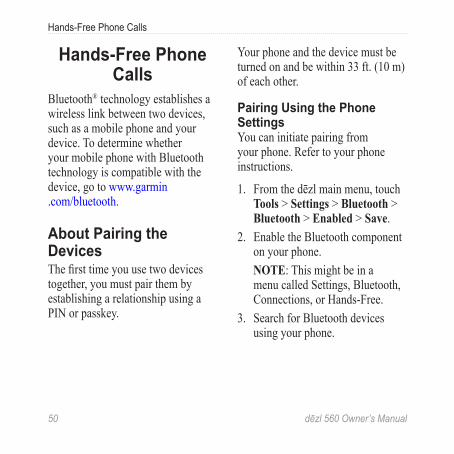
Bluetooth® technology establishes a wireless link between two devices, such as a mobile phone and your device. To determine whether your mobile phone with Bluetooth technology is compatible with the device, go to www.garmin.com/bluetooth.
About Pairing the DevicesThe first time you use two devices together, you must pair them by establishing a relationship using a PIN or passkey.
Your phone and the device must be turned on and be within 33 ft. (10 m) of each other.
Pairing Using the Phone SettingsYou can initiate pairing from your phone. Refer to your phone instructions.
1. From the dēzl main menu, touch Tools > Settings > Bluetooth > Bluetooth > Enabled > Save.
2. Enable the Bluetooth component on your phone.
NOTE: This might be in a menu called Settings, Bluetooth, Connections, or Hands-Free.
3. Search for Bluetooth devices using your phone.
dēzl 560 Owner’s Manual 51
Hands-Free Phone Calls
4. Select the dēzl from the list of devices.
5. If necessary, enter the device Bluetooth PIN (1234) into your phone.
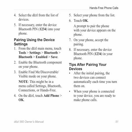
Pairing Using the Device Settings1. From the dēzl main menu, touch
Tools > Settings > Bluetooth > Bluetooth > Enabled > Save.
2. Enable the Bluetooth component on your phone.
3. Enable Find Me/Discoverable/Visible mode on your phone.
NOTE: This might be in a menu called Settings, Bluetooth, Connections, or Hands-Free.
4. On the dēzl, touch Add Phone > OK.
5. Select your phone from the list.6. Touch OK.
A prompt to pair the phone with your device appears on the phone.
7. On your phone, accept the pairing.
8. If necessary, enter the device Bluetooth PIN (1234) in your phone.
Tips After Pairing Your Devices• After the initial pairing, the
two devices can connect automatically each time you turn them on.
• When your phone is connected to your device, you are ready to make phone calls.

52 dēzl 560 Owner’s Manual
Hands-Free Phone Calls
• When you turn on the device, it tries to connect to the last phone to which it was connected.
• You might have to set your mobile phone to connect to the device automatically when it is turned on.
Managing the Bluetooth Device ListYou can add, disconnect, or delete phones that your device detects while Bluetooth is enabled.
1. From the main menu, touch Tools > Settings > Bluetooth > Add Phone.
2. Select an option:• Select a phone for your device
to connect with.• Touch to add a phone to
the menu.
• Touch to delete a phone from the device memory.
• Touch None to drop your current connection.
Receiving a Call • Touch Answer. • Touch Ignore to ignore the call.
Using the Device During a Call During a call, appears. Depending on the screen shown on your device, the In Call icon could look different.
1. From the main menu, touch > End Call.
2. Select an option:• Touch Keypad to view
a keypad page for using automated systems such as voice mail.
dēzl 560 Owner’s Manual 53
Hands-Free Phone Calls
• Touch Handset to turn off the device but remain on the call, or if you need privacy.TIP: To switch back, touch Hands-free.
• Touch Mute to turn off the sound on a call.
Using Call WaitingWhen you are on a call and you receive a second call (call waiting), a window appears.
• Touch Answer to answer the call and place the first call on hold.
• Touch > Switch To. • Touch End Call to hang up.
This does not disconnect the call on hold.
Dialing a Point of Interest1. From the main menu, touch
Phone > Points of Interest. 2. Search for a point of interest. 3. Touch Call.
Dialing a Number1. From the main menu, touch
Phone > Dial. 2. Enter the number.3. Touch Dial.
Entering Your Phone NumberYou can enter the phone number you want the device to call when you touch Call Home.
54 dēzl 560 Owner’s Manual
Hands-Free Phone Calls
1. From the main menu, touch Phone > Call Home.
2. Touch Enter Phone Number. 3. Enter the phone number.4. Touch Done > Yes. The device dials your home
phone number.
Calling HomeBefore you can call home, you must enter a phone number for your home location (page 53).
From the main menu, touch Phone > Call Home.
Placing Calls Using Voice DialBefore you can place calls using voice dial, you may need to train your phone to recognize your voice dial commands. Refer to your phone instructions.
1. From the main menu, touch Phone > Voice Dial.
2. Speak the contact name.
Checking the Phone StatusYou can check the battery level and signal strength for your phone.
From the main menu, touch Phone > Phone Status.
dēzl 560 Owner’s Manual 55
Data Management
Data ManagementYou can store files, such as JPEG image files, on your device. The device has a memory card slot for additional data storage.
NOTE: The device is not compatible with Windows® 95, 98, Me, Windows NT®, and Mac® OS 10.3 and earlier.
File TypesThe device supports these file types.
• JPEG and JPG image files(page 47).
• Maps and GPX waypoint files from MapSource® (page 75).
• GPI custom POI files from Garmin POI Loader (page 75).
About Memory CardsYou can purchase memory cards from an electronics supplier, or you can purchase pre-loaded Garmin mapping software (www.garmin.com/trip_planning). In addition to map storage, the memory card can be used to store files such as maps, images, geocaches, routes, waypoints, and custom POIs.
56 dēzl 560 Owner’s Manual
Data Management
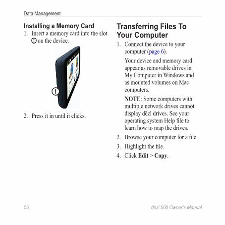
Installing a Memory Card1. Insert a memory card into the slot
➊ on the device.
➊
2. Press it in until it clicks.
Transferring Files To Your Computer 1. Connect the device to your
computer (page 6).Your device and memory card appear as removable drives in My Computer in Windows and as mounted volumes on Mac computers. NOTE: Some computers with multiple network drives cannot display dēzl drives. See your operating system Help file to learn how to map the drives.
2. Browse your computer for a file. 3. Highlight the file.4. Click Edit > Copy.
dēzl 560 Owner’s Manual 57
Data Management
5. Open the “Garmin” or memory card drive or volume.
6. Select Edit > Paste. The file appears in the list of files
in the device memory or on the memory card.
Disconnecting the USB Cable1. Complete an action:
• For Windows computers, click the eject icon in your system tray.
• For Mac computers, drag the volume icon to the Trash .
2. Disconnect the cable from your computer.
Deleting Files NOTICE
If you do not know the purpose of a file, do not delete it. Your device memory contains important system files that should not be deleted.
1. Open the “Garmin” drive or volume.
2. If necessary, open a folder or volume.
3. Select a file.4. Press the Delete key on your
keyboard.
58 dēzl 560 Owner’s Manual
Customizing the Device
Customizing the Device
System SettingsFrom the main menu, touch Tools > Settings > System.
• GPS Simulator—stops the device from receiving a GPS signal, and saves battery power.
• Units—allows you to change the units of measure for distance.
• Time Format—allows you to select a 12-hour, 24-hour, or UTC display time.
• Current Time—allows you to manually change the time.
• Safe Mode—disables all functions that require significant operator attention and could become a distraction while driving.
• Garmin Lock—locks the device (page 71).
• About—displays the software version number, the unit ID number, and information on several other software features.NOTE: You need this information when you update the system software or purchase additional map data (page 75).
• End User License Agreements
Customizing the Main MenuYou can create a customized main menu that contains up to 15 icons.
1. From the main menu, select Tools > Settings > Main Menu.
2. If necessary, select Customize.3. Select .
dēzl 560 Owner’s Manual 59
Customizing the Device
4. If necessary, select .5. Select an icon.6. Select Save.
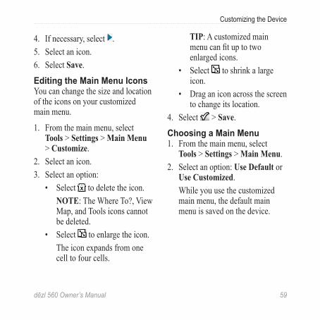
Editing the Main Menu IconsYou can change the size and location of the icons on your customized main menu.
1. From the main menu, select Tools > Settings > Main Menu > Customize.
2. Select an icon.3. Select an option:
• Select to delete the icon.NOTE: The Where To?, View Map, and Tools icons cannot be deleted.
• Select to enlarge the icon.The icon expands from one cell to four cells.
TIP: A customized main menu can fit up to two enlarged icons.
• Select to shrink a large icon.
• Drag an icon across the screen to change its location.
4. Select > Save.
Choosing a Main Menu1. From the main menu, select
Tools > Settings > Main Menu.2. Select an option: Use Default or
Use Customized.While you use the customized main menu, the default main menu is saved on the device.
60 dēzl 560 Owner’s Manual
Customizing the Device
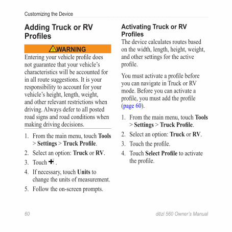
Adding Truck or RV Profiles
WARNINGEntering your vehicle profile does not guarantee that your vehicle’s characteristics will be accounted for in all route suggestions. It is your responsibility to account for your vehicle’s height, length, weight, and other relevant restrictions when driving. Always defer to all posted road signs and road conditions when making driving decisions.
1. From the main menu, touch Tools > Settings > Truck Profile.
2. Select an option: Truck or RV.3. Touch .4. If necessary, touch Units to
change the units of measurement.5. Follow the on-screen prompts.
Activating Truck or RV ProfilesThe device calculates routes based on the width, length, height, weight, and other settings for the active profile.
You must activate a profile before you can navigate in Truck or RV mode. Before you can activate a profile, you must add the profile (page 60).
1. From the main menu, touch Tools > Settings > Truck Profile.
2. Select an option: Truck or RV.3. Touch the profile.4. Touch Select Profile to activate
the profile.
dēzl 560 Owner’s Manual 61
Customizing the Device
Editing Truck or RV ProfilesBefore you can delete a profile, you must activate a different profile (page 60).
1. From the main menu, touch Tools > Settings > Truck Profile.
2. Touch a profile, and touch .3. Select an option: Edit or Delete.
Automobile, Truck, and RV Navigation SettingsFrom the main menu, touch Tools > Settings > Navigation, and select Automobile, Truck, or RV.
• nüRoute™ —see page 63.• Map Detail—sets the level of
detail on the map. More detail may cause the map to draw slower.
• Map View—sets the perspective on the map (page 62).
• Map Theme—changes the color of the map data.
• Map Data Layout—changes the amount of data visible on the map.
• Vehicle—changes the icon to represent your position on the map. Go to www.garmingarage.com for more icons.
• Trip Log ◦ Show on Map—displays the
path of your travels on the map.
◦ Clear Trip Log• Proximity Points—changes the
proximity points setting (page 62).
• Sharp Curve Warnings—allows you to set alerts for sharp curves.
62 dēzl 560 Owner’s Manual
Customizing the Device
Changing the Map Perspective1. From the main menu, touch Tools
> Settings > Navigation.2. Select an option: Automobile,
Truck, or RV.3. Touch Map View.4. Select an option:
• Touch Track Up to display the map in two dimensions (2-D), with your direction of travel at the top.
• Touch North Up to display the map in 2-D with North at the top.
• Touch 3-D to display the map in three dimensions.
Choosing Proximity Points SettingsThis option is visible only if you have proximity points or safety cameras loaded on your device. Proximity points include custom POIs and safety camera databases. Go to www.garmin.com/extras for more information.
1. From the main menu, touch Tools > Settings > Navigation.
2. Select an option: Automobile, Truck, or RV.
3. Touch Proximity Points.4. Select an option:
• Touch Alerts to enable alerts that sound as you approach proximity points.
• Touch Audio to set the type of alerts that sound as you approach proximity points.
dēzl 560 Owner’s Manual 63
Customizing the Device
Pedestrian Navigation SettingsFrom the main menu, touch Tools > Settings > Navigation > Pedestrian.
• Limit Walking—controls how much of a public transit route will include walking.
• Public Transit—avoids selected transit types.
• Trip Log—displays the path of your travels on the map. ◦ Show on Map—displays the
path of your travels on the map.
◦ Clear Trip Log
Avoiding Transit TypesNOTE: Transit types are available when cityXplorer maps are loaded (page 29).
1. From the main menu, touch Tools > Settings > Navigation > Pedestrian > Public Transit.
2. Select the transit type to avoid on your routes.
3. Touch Save.
Choosing Route Preferences1. From the main menu, touch Tools
> Settings > Navigation.2. Select an option: Automobile,
Truck, or RV.3. Touch nüRoute > Calculation
Mode.The route calculation is based on road speeds and vehicle acceleration data for a given route.
64 dēzl 560 Owner’s Manual
Customizing the Device
4. Select an option, if available:• Touch Faster Time to
calculate routes that are faster to drive but can be longer in distance.
• Touch Shorter Distance to calculate routes that are shorter in distance but can take more time to drive.
• Touch Less Fuel to calculate routes that could use less fuel than other routes.
• Touch Prompted to select a route calculation mode before navigating (page 26).
• Touch Off Road to calculate a direct line from your location to your destination.
Avoiding Road Features1. From the main menu, touch Tools
> Settings > Navigation.2. Select an option: Automobile,
Truck, or RV.3. Touch nüRoute > Avoidances.4. Select the road features to avoid
on your routes.5. Touch Save.
Setting Custom AvoidancesYou can set specific areas or roads for your device to avoid when calculating routes.
1. From the main menu, touch Tools > Settings > Navigation.
2. Select an option: Automobile, Truck, or RV.
dēzl 560 Owner’s Manual 65
Customizing the Device
3. Touch nüRoute > Custom Avoidances.
4. Select Add Avoid Area or Add Avoid Road.
5. Follow the on-screen instructions.
About Advanced DetoursWhen this feature is enabled, the device calculates a new route based on specific options you select (page 27).
Enabling Advanced Detours1. From the main menu, touch Tools
> Settings > Navigation.2. Select an option: Automobile,
Truck, or RV.3. Touch nüRoute > Advanced
Detours.4. Select Enabled.
About trafficTrends™
When the trafficTrends feature is enabled, your device uses historic traffic information to calculate more-efficient routes. Different routes may be calculated based on traffic trends for the day of the week or based on the time of day.
Enabling trafficTrends1. From the main menu, touch Tools
> Settings > Navigation.2. Select an option: Automobile,
Truck, or RV.3. Touch nüRoute > trafficTrends
> Enabled.
66 dēzl 560 Owner’s Manual
Customizing the Device
Display SettingsFrom the main menu, touch Tools > Settings > Display.
• Color Mode—sets a light background (Day), a dark background (Night), or automatically switches between the two based on the sunrise time and the sunset time for your current location (Auto).
• Brightness—changes the brightness of the screen. Decreasing the brightness can save battery power.
• Screenshot—allows you to take a picture of the device screen (page 48).
Language SettingsFrom the main menu, touch Tools > Settings > Language.
• Voice Language—sets the language for voice prompts.
• Text Language—sets all on-screen text to the selected language.NOTE: Changing the text language does not change the language of user-entered data or map data, such as street names.
• Keyboard Language—sets the language for your keyboard.
• Keyboard Layout—sets the keyboard layout to QWERTY (similar to a computer keyboard) or alphabetical.
dēzl 560 Owner’s Manual 67
Customizing the Device
Viewing Map Information From the main menu, touch Tools > Settings > myMaps.
Enabling Maps1. From the main menu, touch Tools
> Settings > myMaps.2. Touch a map.
Bluetooth SettingsFrom the main menu, touch Tools > Settings > Bluetooth.
• Add Phone—see page 52.• Bluetooth—enables the
Bluetooth component.The Bluetooth icon appears on the main menu if the Bluetooth component is turned on.
• Friendly Name—allows you to enter a friendly name that identifies your dēzl on devices with Bluetooth technology.
Enabling TrafficThe traffic receiver is included in some device packages.
From the main menu, touch Tools > Settings > Traffic > Traffic > Enabled.
About Traffic SubscriptionsYou can purchase additional subscriptions or a renewal if your subscription expires. Go to www.garmin.com/fmtraffic.
Viewing Traffic SubscriptionsFrom the main menu, touch Tools > Settings > Traffic > Subscriptions.
Restoring Settings1. From the main menu, touch Tools
> Settings.2. If necessary, select a settings
category.3. Select > Restore > Yes.
68 dēzl 560 Owner’s Manual
Appendix
Appendix
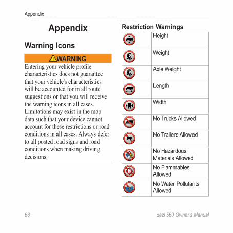
Warning IconsWARNING
Entering your vehicle profile characteristics does not guarantee that your vehicle's characteristics will be accounted for in all route suggestions or that you will receive the warning icons in all cases. Limitations may exist in the map data such that your device cannot account for these restrictions or road conditions in all cases. Always defer to all posted road signs and road conditions when making driving decisions.
Restriction WarningsHeight
Weight
Axle Weight
Length
Width
No Trucks Allowed
No Trailers Allowed
No Hazardous Materials AllowedNo Flammables AllowedNo Water Pollutants Allowed
dēzl 560 Owner’s Manual 69
Appendix
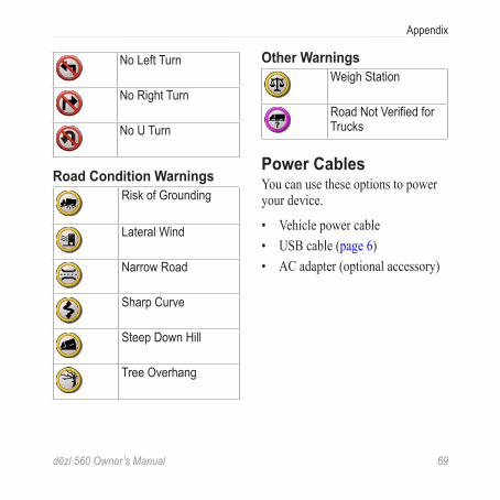
No Left Turn
No Right Turn
No U Turn
Road Condition WarningsRisk of Grounding
Lateral Wind
Narrow Road
Sharp Curve
Steep Down Hill
Tree Overhang
Other WarningsWeigh Station
Road Not Verified for Trucks
Power CablesYou can use these options to power your device.
• Vehicle power cable• USB cable (page 6)• AC adapter (optional accessory)
70 dēzl 560 Owner’s Manual
Appendix
Caring for Your DeviceNOTICE
Avoid dropping your device and operating it in high-shock and high-vibration environments.
Do not expose the device to water.
Contact with water can cause this device to malfunction.
Do not store the device where prolonged exposure to extreme temperatures can occur, because it can cause permanent damage.
Never use a hard or sharp object to operate the touchscreen, or damage may result.
Cleaning the Outer CasingNOTICE
Avoid chemical cleaners and solvents that can damage plastic components.
1. Clean the outer casing of the device (not the touchscreen) using a cloth dampened with a mild detergent solution.
2. Wipe the device dry.
Cleaning the Touchscreen1. Use a soft, clean, lint-free cloth.2. If necessary, use water, isopropyl
alcohol, or eyeglass lens cleaner.3. Apply the liquid to the cloth.4. Gently wipe the screen with the
cloth.
dēzl 560 Owner’s Manual 71
Appendix
Avoiding Theft• Remove the device and mount
from sight when not in use. • Remove the residue left on the
windshield by the suction cup. • Do not keep your unit in the
glove compartment. • Register your device at
http://my.garmin.com. • Use the Garmin Lock™ feature
(page 71).
About Garmin LockGarmin Lock is a theft-deterrent system that locks your device. Each time you turn on the device, you must enter the PIN or drive to the security location.
About the Security LocationYour security location should be a location you return to often, such as your home. If the device has satellite signals and you are at the security location, you do not need to enter the PIN.
NOTE: If you forget your PIN and your security location, you must send your device to Garmin to get it unlocked. You must also send a valid product registration or proof of purchase.
Locking the Device1. From the main menu, touch Tools
> Settings > System > Garmin Lock > Lock Device. The Garmin Lock menu appears.
2. Touch Enabled.3. Enter a 4-digit PIN twice.4. Drive to a security location.5. Touch Set.
72 dēzl 560 Owner’s Manual
Appendix
Changing Your Garmin Lock PIN1. From the Garmin Lock menu,
touch Change PIN.2. Enter a new 4-digit PIN twice.
Changing Your Security Location1. From the Garmin Lock menu,
touch Security Location.2. Drive to the new security
location.3. Touch Set.
Erasing User Data1. Turn on the device.2. Hold your finger on the lower-
right corner of the device screen.3. Keep your finger pressed until the
pop-up window appears. 4. Touch Yes.
All original settings are restored. Any items that you have saved are erased.
Battery Information The battery icon in the status bar indicates the status of the internal battery.
To increase the accuracy of the battery gauge, fully discharge the battery and then fully charge it. Do not unplug the device until it is fully charged.
Maximizing the Battery Life• From the main menu, touch
Tools > Settings > Display > Brightness to turn down the backlight.
• Do not leave your device in direct sunlight.
• Avoid prolonged exposure to excessive heat.
dēzl 560 Owner’s Manual 73
Appendix
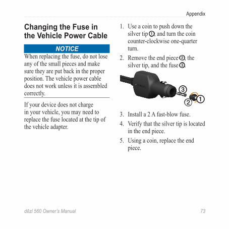
Changing the Fuse in the Vehicle Power Cable
NOTICEWhen replacing the fuse, do not lose any of the small pieces and make sure they are put back in the proper position. The vehicle power cable does not work unless it is assembled correctly.
If your device does not charge in your vehicle, you may need to replace the fuse located at the tip of the vehicle adapter.
1. Use a coin to push down the silver tip ➊, and turn the coin counter-clockwise one-quarter turn.
2. Remove the end piece ➋, the silver tip, and the fuse ➌.
➊➋
➌
3. Install a 2 A fast-blow fuse.4. Verify that the silver tip is located
in the end piece. 5. Using a coin, replace the end
piece.
74 dēzl 560 Owner’s Manual
Appendix
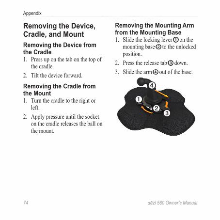
Removing the Device, Cradle, and MountRemoving the Device from the Cradle1. Press up on the tab on the top of
the cradle.2. Tilt the device forward.
Removing the Cradle from the Mount1. Turn the cradle to the right or
left.2. Apply pressure until the socket
on the cradle releases the ball on the mount.
Removing the Mounting Arm from the Mounting Base1. Slide the locking lever ➊ on the
mounting base ➋ to the unlocked position.
2. Press the release tab ➌ down.3. Slide the arm ➍ out of the base.
➊➋
➌
➍
dēzl 560 Owner’s Manual 75
Appendix
About nüMaps Lifetime™ For a one-time payment, you can receive up to four map updates each year for the life of your device. For more information on nüMaps Lifetime and complete terms and conditions, go to www.garmin.com/numaps, and click Maps.
Device Models• Models with “LM” after the
model number include a nüMaps Lifetime subscription.
• Models with “LT” after the model number include a lifetime traffic subscription and a traffic receiver.
• Models with “LMT” after the model number include a nüMaps Lifetime subscription, a lifetime traffic subscription (page 75), and a traffic receiver.
Purchasing Additional MapsYou can purchase additional maps for your device.
1. Go to your device product page on the Garmin Web site (www.garmin.com).
2. Click the Maps tab.3. Follow the on-screen instructions.
Custom Points of Interest Custom POIs are customized points on the map. They can contain alerts that let you know if you are near a designated point or if you are traveling faster than a specified speed.
76 dēzl 560 Owner’s Manual
Appendix
Installing a POI LoaderYou can create or download custom POI lists and install them on your device using POI Loader software.
1. Go to www.garmin.com/extras.2. Click Services > POI Loader.3. Install the POI Loader onto your
computer.Using the POI Loader Help FilesFor more information on the POI Loader, refer to the Help file.
With the POI Loader open, click Help.
Finding Extras1. From the main menu, touch
Where To? > Extras.2. Select a category.
Safety Cameras CAUTION
Garmin is not responsible for the accuracy of, or the consequences of using, a custom point of interest or a safety camera database.
Safety camera information is available in some locations. Go to http://my.garmin.com for availability. For these locations, the device includes the locations of hundreds of safety cameras. Your device alerts you when you are approaching a safety camera and can warn you if you are driving too fast. The data is updated at least weekly, so you always have access to the most up-to-date information.
dēzl 560 Owner’s Manual 77
Appendix
You can purchase a new region or extend an existing subscription at any time. Each region that you purchase has an expiration date.
Purchasing AccessoriesGo to http://buy.garmin.com.
Contacting Garmin Product SupportYou can contact Garmin Product Support if you have any questions about this product.
• In the USA, go to www.garmin.com/support, or contact Garmin USA by phone at (913) 397.8200 or (800) 800.1020.
• In the UK, contact Garmin (Europe) Ltd. by phone at 0808 2380000.
• In Europe, go to www.garmin.com/support and click Contact Support for in-country support information, or contact Garmin (Europe) Ltd. by phone at +44 (0) 870.8501241.
SpecificationsOperating temperature range:
32°F–140°F (0°C–60°C)Charging temperature range:
32°F–113°F (0°C–45°C)
78 dēzl 560 Owner’s Manual
Appendix
TroubleshootingProblem SolutionMy device is not acquiring satellite signals.
• Verify that the GPS simulator is turned off. • From the main menu, touch Tools > Settings >
System > GPS Simulator > Off. • Take your device out of parking garages and away
from tall buildings and trees. • Remain stationary for several minutes.
The device does not charge in my vehicle.
• Check the fuse in the vehicle power cable (page 73).
• Verify the vehicle is turned on and is supplying power to the power outlet.
• Your device can only charge between 32°F and 113°F (between 0°C and 45°C). If the device is placed in direct sunlight or in a hot environment, it cannot charge.
My battery does not stay charged for very long.
To maximize the time between charges, turn down the backlight (page 66).
How do I clear all of my user data?
See page 72.
My battery gauge does not seem accurate.
Allow the unit to fully discharge, and fully charge it (without interrupting the charge cycle).
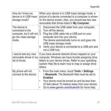
dēzl 560 Owner’s Manual 79
Appendix
How do I know my device is in USB mass storage mode?
When your device is in USB mass storage mode, a picture of a device connected to a computer is shown on the device screen. Also, you should see two new removable disk drives listed in My Computer.
The device is connected to the computer, but it will not go into mass storage mode.
1. Disconnect the USB cable from your computer. 2. Turn off the device. 3. Plug the USB cable into a USB port on your
computer and into your device. The device automatically turns on and goes into
USB mass storage mode. 4. Verify your device is connected to a USB port and
not a USB hub.I cannot see any new removable drives in my list of drives.
If you have several network drives mapped on your computer, Windows can have trouble assigning drive letters to your device drives. Refer to your operating system Help file to learn how to map or assign drive letters.
My phone will not connect to the device.
• From the main menu, touch Tools > Settings > Bluetooth. The Bluetooth field must be set to Enabled.
• Your phone must be turned on and be less than 33 feet (about 10 meters) away from your device.
• Go to www.garmin.com/bluetooth for more help.
Index
80 dēzl 560 Owner’s Manual
IndexNumbers2-D, 3-D map view 62
Aaccessories 77acquiring satellite signals
7, 7–8addresses, finding 12adhesive pad 3–5advanced detours 65anti-theft feature 71avoiding
areas and roads 64–65public transit types 63road features 64theft 71, 71–72traffic 32
Bbackup camera 11battery
heat and 1information 72
life 72, 78Bluetooth technology
50–54pairing with a phone
50–52settings 67
breakdown directory 13brightness, adjusting 8businesses and attractions,
finding 15–17buttons, on-screen 10
Ccalculator 48calls
answering 52call waiting 53hanging up 52home 54making 53muting 53to businesses 53voice dial 54
camerasbackup 11
safety 76–77caring for your device
70–71changing the fuse 73charging your device 78cityXplorer maps 29, 63cleaning your device 6, 70clearing. See deletingclock 48computer, connecting
to 6–7converting
currency 49units of measure
48–49coordinates 19cradle, removing 74current location 43current location, saving 18customized main menu
settings 58–59custom points of interest
75–76custom points of interest,
safety cameras and 76
Index
dēzl 560 Owner’s Manual 81
Ddash mount 3–5deleting
favorites 19files 57recently found
locations 17user data 72
destinations, multiple 20–21
detoursadvanced 65taking 27–28
devicecare 70–71charging 78help 43pairing with a phone
50–52protecting 70–71registering 6removing 74resetting 8
device settings, Bluetooth and 51
display settings 66drivers, truck 40driving directions 25driving logs 39
exporting 42viewing exported 42
duty status 39
EecoRoute
calibrating fuel economy 44
ecoChallenge score 45fuel economy
information 45mileage report 46tips 46vehicle profile 46
end user license agreements 58
erasing. See deletingexit services 14exporting
driving logs 42
jurisdiction summaries 36–37
trip reports 37extras 75
Ffavorites 17–19
deleting 19editing 18–19finding 18saving locations to 18saving your current
location to 18files
deleting 57supported types 55
friction mount 2–3fuel
data 35–36finding 43logs 36
fuel economy, calibrating 44
fuel economy information 45
Index
82 dēzl 560 Owner’s Manual
fuse, changing 73
GGarmin Lock 71–72Garmin Product Support
77geocaching 19GPS
satellite signals 7–8settings 58simulator 21, 58
guarantee, nuMaps 6
Hhelp 43home
calling 54editing location
information 15navigating 15phone number 54resetting the location
15setting a location 14
hospitals 43hours of service 38–42
drivers 40driving logs 39, 42duty status 39regulations 38shipments 40–41
IIFTA (International Fuel
Tax Agreement) 35IFTA logging 35–38
exported summaries and reports 38
fuel data 35–36fuel logs 36jurisdiction summary
36–37trip reports 37–38
Important Safety and Product Information guide 1, 5
installing the mount 1–5International Fuel Tax
Agreement (IFTA) 35
JJPEG image files 55
junction view 26jurisdiction summary
36–37
Kkeyboard 10
Llanguage settings 66latitude and longitude 19lithium-ion battery 1, 72loading pictures 16–19location, current 43location map options
12–13location, security 71locations, finding
addresses 12businesses and
attractions 15–17coordinates 19home 15recently found 17saved locations
(favorites) 18trucking points of
Index
dēzl 560 Owner’s Manual 83
interest 14–19using photos 16–17using the map 13
locations, saving to favorites 18
locking the device 71logs
driving 38, 39fuel 36
Mmain menu 9
customizing 58–59default 59editing 59
mapsadding 75cityXplorer 29, 63errors 16information 67location 12–13navigation 23pedestrian 28–29purchasing 75settings 61–62
updating 7MapSource 55, 75mass storage mode 55–57,
79measurements, converting
48–49memory cards 55–56memory card slot 8micro-B connector 6–7microSD card slot 8mileage reports 46modes, transportation 11mounting the device
installing 1–5removing from mount
74mounts
dash 3–5friction 2–3removing 74
multiple destinations 20–21
mutingaudio 9phone calls 53
myDashboard 6–7myMaps settings 67myTrends 28
Nnavigation
maps 23off road 64pedestrian 28photo 16–19
navigation settingspedestrian 63vehicle 61–62
nearby services 43next turn 25NTTS. See breakdown
directorynüMaps guarantee 6nüMaps Lifetime 75
Ooffers (ad-based)
disabling 34viewing 34
off-road navigation 64on-screen buttons 10
Index
84 dēzl 560 Owner’s Manual
Ppad, adhesive 3–4pairing a mobile phone
50–52pedestrian maps 28–29pedestrian mode, settings
63phone, pairing 50–52phone settings, Bluetooth
and 50–51phone status 54photo navigation 16–19picture viewer 47PIN
Bluetooth 51Garmin Lock 71
POI loader 55POI loader software 76points of interest
calling 53custom 75–76finding 15–17rating 17removing incorrect 16
reporting incorrect 16–17
trucking 14police stations 43portable friction mount
2–3power cables 69power key 8predictive routing 28present location 43present location, saving 18product support 77profiles
truck or RV 7, 60–61vehicle (ecoRoute) 46
protecting your device 70–71
public transitavoidances 63city maps 29
purchasing maps 75
Rrating points of interest 16recalculating routes
detours 27–28traffic 32
receiver, traffic 30–34recently found locations
17registering the device 6regulations, hours of
service 38removing incorrect points
of interest 16removing the device,
cradle, and mount 74reports
mileage 46trip 37–38
resettingdevice 8home location 15trip information 24
restoring settings 67restrictions, vehicle 7, 60reverse camera 11route preferences 26–28routes. See tripsroute settings 63–65
Index
dēzl 560 Owner’s Manual 85
RVprofiles 7, 60–61settings 61–62
Ssafe mode 58safety cameras 76–77satellite signals 7, 7–8saved locations.
See favoritessaving
found locations 18your current location
18school zone database 75score, ecoChallenge 45screen
brightness 8, 66buttons 10keyboard 10
screenshots 48search area 17search area, changing 19security
Garmin Lock 71–72
location 71theft, avoiding 71
security location 71services
exit 14nearby 43
settingsBluetooth 67customized main
menu 58–59display 66GPS 58language 66map 61–62, 67navigation, pedestrian
63navigation, vehicle
61–62restoring 67route 63–65simulator 21, 58system 58traffic 67truck or RV 60–61
shipments 40–41
simulator 21, 58software
information 58updating 6version 58
specifications 77speed limit feature 22status, duty 39storing the device 70subscriptions, traffic
30, 67support 77system settings 58
Ttheft, avoiding 71tips
Bluetooth 51–52driving 46troubleshooting 78–79
trafficavoiding 32icons 31receiver 30–34route recalculation 32
Index
86 dēzl 560 Owner’s Manual
settings 67subscriptions 30, 67trafficTrends 65
traffic information, accuracy and availability 30
transportation modes 11trip information
resetting 24viewing 24
trip reports 37–38trips 20–21troubleshooting 78–79truck
drivers 40profiles 7, 60–61settings 61–62shipments 40–41speed limits 22
TruckDown. See breakdown directory
trucking points of interest 14–19
turn-by-turn directions 25
turn, next 25
Uunit converter 48–49unit ID 58USB connector
cradle 2, 4device 6traffic receiver 30
USB mass storage mode 55–57, 79
user data, deleting 72
Vvehicle profiles
ecoRoute 46truck or RV 7, 60–61
vehicle restrictions 7, 60version information 58viewing
junctions 26trip information 24
voice dial 54volume 11
Wwallpaper 47warning icons, truck and
RV 68–69warnings, product 1windshield mounting 5world clock, world map
48


For the latest free software updates (excluding map data) throughout the life of your Garmin products, visit the Garmin Web site at www.garmin.com.
© 2012 Garmin Ltd. or its subsidiaries
Garmin International, Inc. 1200 East 151st Street, Olathe, Kansas 66062, USA
Garmin (Europe) Ltd. Liberty House, Hounsdown Business Park, Southampton, Hampshire, SO40 9LR UK
Garmin Corporation No. 68, Jangshu 2nd Road, Sijhih, Taipei County, Taiwan
www.garmin.com
June 2012 Part Number 190-01280-00 Rev. B Printed in Taiwan
![560 – 579 560. The Festival of Temuir [celebrated] by … 560 to 579.pdf560 – 579 560. The Festival of Temuir [celebrated] by Diarmait, son of Cerball. 560 Annals of Ulster The](https://img.pdfslide.us/doc/110x75/5b0051c87f8b9a84338c75d3/560-579-560-the-festival-of-temuir-celebrated-by-560-to-579pdf560-.jpg)