Embed Size (px)
Citation preview

Development of the Gulf of Guayaquil (Ecuador) during the
Quaternary as an effect of the North Andean block tectonic escape
Cesar Witt,1,2 Jacques Bourgois,1,2,3,4 Francois Michaud,1,2 Martha Ordonez,5
Nelson Jimenez,5 and Marc Sosson1
Received 5 August 2004; revised 27 December 2005; accepted 17 March 2006; published 21 June 2006.
[1] Interpretation of industrial multichannel seismicprofiles and well data are used to identify the maintectonic features of the Gulf of Guayaquil (GG) area.These include two E-W trending major detachments:the Posorja and the Jambelı detachment systems,which represent half grabens with oppositely dippingdetachments, to the south and to the north,respectively. The NE-SW trending Puna-Santa Clarafault system developed as a transfer fault systembetween the Posorja and the Jambelı detachments. TheEsperanza and the Jambelı basins exhibit 3–4 km ofsediment that accumulated during the past 1.6–1.8 Myr. The Puna-Santa Clara fault system boundsthe Esperanza and the Jambelı basins, evidencingthat the evolution of these basins is tightly controlledby the two detachments at depth. To the west, the N-Strending Domito fault system bounding the Posorjadetachment system and the Esperanza basin to thewest acted as a transfer zone between the shelf areaand the continental slope. The Pliocene series show nosignificant variations in thickness throughout the Gulfof Guayaquil area suggesting that no importanttectonic deformation occurred from 5.2 to 1.8–1.6 Ma. The major period of tectonic deformation inthe Gulf of Guayaquil area occurred during thePleistocene times. Three main tectonic steps areidentified. From early Pleistocene to �180 ka, majorsubsidence occurred along the Esperanza and Jambelıbasins. From �180 to �140 ka, most of the Gulf ofGuayaquil area was above sea level during the isotopesubstage 6 low stand. From �140 ka to Present,tectonic activity is restricted along the normal faultsbounding the Esperanza basin, the Tenguel fault, andthe Puna-Santa Clara and Domito fault systems. A N-Strending tensional stress regime characterizes the
Pleistocene times throughout. The northward driftingof the North Andean block is proposed to controlthe tectonic evolution and associated subsidence of theGulf of Guayaquil area. It is also accepted that thecollision of the Carnegie ridge with the trench axis hasto play a major role in controlling the North Andeanblock northward drift. Because the Carnegie ridgesubduction is possibly an ongoing process, whichbegan prior to the Pliocene, we postulate the along-strike morphology of the ridge at the origin ofinterplate coupling variations. The subduction of analong-strike positive relief of the ridge is proposed atthe origin of the major tectonic reorganization of theGG area occurring at �1.8–1.6 Ma. Citation: Witt, C.,
J. Bourgois, F. Michaud, M. Ordonez, N. Jimenez, and M. Sosson
(2006), Development of the Gulf of Guayaquil (Ecuador) during
the Quaternary as an effect of the North Andean block tectonic
escape, Tectonics, 25, TC3017, doi:10.1029/2004TC001723.
1. Introduction
[2] Active tectonic deformation in the Ecuadorian Andeshas been the subject of many studies during the last 15 years[Winter and Lavenu, 1989; Soulas et al., 1991; Tibaldi andFerrari, 1992; Winter et al., 1993; Ego et al., 1996].Nevertheless, few studies deal with the analyses of thecoastal active tectonics and the evolution of the Gulf ofGuayaquil (GG) area through time. In the GG area(Figure 1), the so-called Dolores-Guayaquil Fault System(DGFS) was considered to be part of the eastern activeboundary of the North Andean block (NAB), the northwardmotion of which was proposed to be at the origin of the GGarea subsidence [Campbell, 1974; Shepherd and Moberly,1981]. Deniaud et al. [1999] interpreted the tectonic defor-mation of the GG area as a consequence of an extensionalstrain associated with the northward drifting of the NAB.They proposed that the first phase of subsidence took placein the GG area during the Pliocene, the GG area developingas a pull-apart basin along the NAB eastern limit. However,the evolution of the GG area and the role of the NABeastern limit in its development remain poorly understood.[3] On the basis of multichannel seismic reflection pro-
files and well data acquired by Petroecuador (EcuadorianPetroleum Company) during the past two decades, wedocument the geodynamic evolution of the GG area forthe past 2 Myr. The study area includes (Figure 1b) offshorezones located on either side of the Puna and Santa Clara
TECTONICS, VOL. 25, TC3017, doi:10.1029/2004TC001723, 2006
1UMR Geosciences Azur, Observatoire Oceanologique de Villefranche-sur-Mer, Nice, France.
2Escuela Politecnica Nacional, Departamento de Geologıa, Quito,Ecuador.
3Centre National de la Recherche Scientifique, Paris, France.4Institut de Recherche pour le Developpement, Paris, France.5Geological Research Centre of Guayaquil, Petroproduccion, Guaya-
quil, Ecuador.
Copyright 2006 by the American Geophysical Union.0278-7407/06/2004TC001723$12.00
TC3017 1 of 22
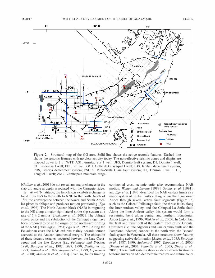
islands. Data are confined to above 100 m water depth,landward from the shelf slope break. We have identifiedthree major tectonic features: the Esperanza and Jambelıbasins and a diapiric zone located at the seaward edge of thecontinental platform. The evolution of these features iscontrolled by six main active fault systems (Figure 2),which include: the Puna-Santa Clara fault system (PSCFS),the Posorja detachment system (PDS), the Tenguel fault, theDomito fault system (DFS), the Esperanza graben, and theJambelı detachment system (JDS). These major structureshave been poorly characterized in previous studies. Theirdescription improves available constraints on the tectonicreconstruction and subsidence history of the area. In addi-tion, we present detailed mapping of the active structuresand their evolution through time, and a geodynamic sce-nario for the Pliocene and Quaternary based on theseconstraints.
2. Geodynamics and Geologic Framework
[4] The Nazca plate (Figure 1) is subducting eastwardbeneath the South America plate at a rate of about 6–7 cm/yrin an E-W direction [Freymueller et al., 1993; Kellogg andVega, 1995; Trenkamp et al., 2002]. The dip angle ofsubduction ranges between 25� and 35� [Pennington,1981; Guillier et al., 2001]. The Carnegie ridge is an
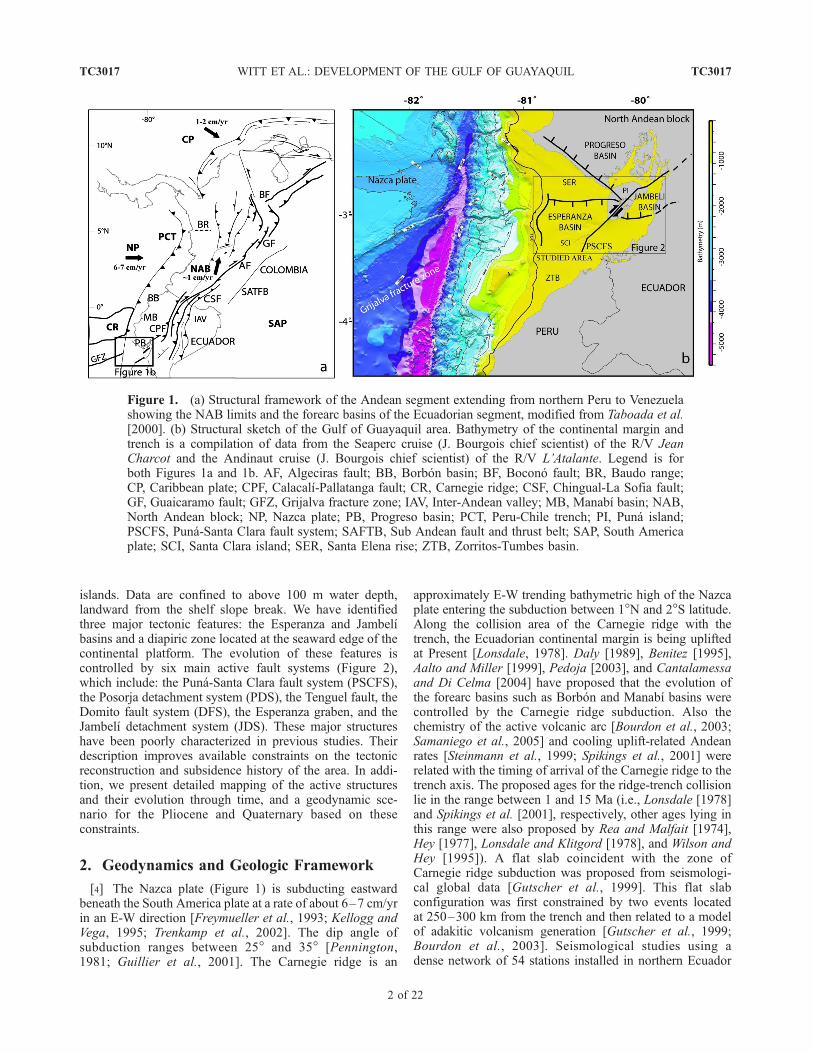
approximately E-W trending bathymetric high of the Nazcaplate entering the subduction between 1�N and 2�S latitude.Along the collision area of the Carnegie ridge with thetrench, the Ecuadorian continental margin is being upliftedat Present [Lonsdale, 1978]. Daly [1989], Benitez [1995],Aalto and Miller [1999], Pedoja [2003], and Cantalamessaand Di Celma [2004] have proposed that the evolution ofthe forearc basins such as Borbon and Manabı basins werecontrolled by the Carnegie ridge subduction. Also thechemistry of the active volcanic arc [Bourdon et al., 2003;Samaniego et al., 2005] and cooling uplift-related Andeanrates [Steinmann et al., 1999; Spikings et al., 2001] wererelated with the timing of arrival of the Carnegie ridge to thetrench axis. The proposed ages for the ridge-trench collisionlie in the range between 1 and 15 Ma (i.e., Lonsdale [1978]and Spikings et al. [2001], respectively, other ages lying inthis range were also proposed by Rea and Malfait [1974],Hey [1977], Lonsdale and Klitgord [1978], and Wilson andHey [1995]). A flat slab coincident with the zone ofCarnegie ridge subduction was proposed from seismologi-cal global data [Gutscher et al., 1999]. This flat slabconfiguration was first constrained by two events locatedat 250–300 km from the trench and then related to a modelof adakitic volcanism generation [Gutscher et al., 1999;Bourdon et al., 2003]. Seismological studies using adense network of 54 stations installed in northern Ecuador
Figure 1. (a) Structural framework of the Andean segment extending from northern Peru to Venezuelashowing the NAB limits and the forearc basins of the Ecuadorian segment, modified from Taboada et al.[2000]. (b) Structural sketch of the Gulf of Guayaquil area. Bathymetry of the continental margin andtrench is a compilation of data from the Seaperc cruise (J. Bourgois chief scientist) of the R/V JeanCharcot and the Andinaut cruise (J. Bourgois chief scientist) of the R/V L’Atalante. Legend is forboth Figures 1a and 1b. AF, Algeciras fault; BB, Borbon basin; BF, Bocono fault; BR, Baudo range;CP, Caribbean plate; CPF, Calacalı-Pallatanga fault; CR, Carnegie ridge; CSF, Chingual-La Sofia fault;GF, Guaicaramo fault; GFZ, Grijalva fracture zone; IAV, Inter-Andean valley; MB, Manabı basin; NAB,North Andean block; NP, Nazca plate; PB, Progreso basin; PCT, Peru-Chile trench; PI, Puna island;PSCFS, Puna-Santa Clara fault system; SAFTB, Sub Andean fault and thrust belt; SAP, South Americaplate; SCI, Santa Clara island; SER, Santa Elena rise; ZTB, Zorritos-Tumbes basin.
TC3017 WITT ET AL.: DEVELOPMENT OF THE GULF OF GUAYAQUIL
2 of 22
TC3017
[Guillier et al., 2001] do not reveal any major changes in theslab dip angle at depth associated with the Carnegie ridge.[5] At �1�N latitude, the trench axis exhibits a change in
trend from N-S to the south to NNE to the north. North of1�N, the convergence between the Nazca and South Amer-ica plates is oblique and produces motion partitioning [Egoet al., 1996]. The North Andean block (NAB) is migratingto the NE along a major right-lateral strike-slip system at arate of 6 ± 2 mm/yr [Trenkamp et al., 2002]. The obliqueconvergence and the subduction of the Carnegie ridge havebeen proposed to be at the origin of the northward driftingof the NAB [Pennington, 1981; Ego et al., 1996]. Along theEcuadorian coast the NAB exhibits mainly oceanic terraneaccreted to the Andean continental margin. The obductionof these oceanic terranes occurred between the Late Creta-ceous and the late Eocene [i.e., Feininger and Bristow,1980; Bourgois et al., 1982, 1987, 1990; Benitez et al.,1993; Jaillard et al., 1997; Reynaud et al., 1999; Lapierre etal., 2000; Mamberti et al., 2003]. Even so, faults limiting
continental crust tectonic units also accommodate NABmotion. Winter and Lavenu [1989], Soulas et al. [1991],and Ego et al. [1996] described the NAB eastern limits as amajor system of dextral faults cutting across the EcuadorianAndes through several active fault segments (Figure 1a)such as the Calacalı-Pallatanga fault, the thrust faults alongthe Inter-Andean valley, and the Chingual-La Sofia fault.Along the Inter-Andean valley this system would form arestraining bend along central and northern EcuadorianAndes [Ego et al., 1996; Winkler et al., 2005]. In Colombia,the fault and thrust belt of the eastern front of the OrientalCordillera (i.e., the Algeciras and Guaicaramo faults and thePamplona indenter) connect to the north with the Boconofault system in Venezuela. All these structures show featuressuggesting active deformation [Boinet et al., 1985; Bourgoiset al., 1987, 1990; Audemard, 1997; Taboada et al., 2000;Dimate et al., 2003; Velandia et al., 2005; Dhont et al.,2005]. These fault systems show evidence of reactivation ortectonic inversion of older tectonic features and suture zones
Figure 2. Structural map of the GG area. Solid line shows the active tectonic features. Dashed lineshows the tectonic features with no clear activity today. The nonreflective seismic zones and diapirs aremapped down to 2 s TWTT. AS1, Amistad Sur 1 well; DFS, Domito fault system; D1, Domito 1 well;E1, Esperanza 1 well; FE1, Fe1 well; GG1, Golfo de Guayaquil 1 well; JDS, Jambelı detachment system;PDS, Posorja detachment system; PSCFS, Puna-Santa Clara fault system; T1, Tiburon 1 well; TL1,Tenguel 1 well; ZMR, Zambapala mountain range.
TC3017 WITT ET AL.: DEVELOPMENT OF THE GULF OF GUAYAQUIL
3 of 22
TC3017

[Audemard, 1997; Guillier et al., 2001; Dimate et al., 2003;Winkler et al., 2005]. Even so, other models suggest that theNAB does not act as a single block moving northward andthat the accommodation of the deformation is more com-plicated since the Caribbean plate (Figure 1a) influences thearea north of 4–5�N [Ego et al., 1996; Taboada et al., 2000;Corredor, 2003; Acosta et al., 2004; Cortes et al., 2005].This model suggests that the zone of transition betweenthe NE-ENE Nazca plate-related compression to the ESECaribbean plate-related compression is placed at 4–5�Nalong an E-W trending transfer zone (i.e., the Baudo range,Figure 1a [Taboada et al., 2000]).[6] The forearc evolution is marked by the develop-
ment of four main basins, from north to south theseinclude: the Borbon, the Manabı, the Progreso, and theGG (Esperanza and Jambelı) basins. All of these basinsshow periods of shallowing or deepening of facies asthey evolved through time [Benitez, 1995; Deniaud,2000]. Except in the GG area, the subsidence of theother basins began approximately during the early Mio-cene. The sediment accumulation of the Esperanza andJambelı basins is mainly composed of clastic depositsranging in age from Mio-Pliocene (prerift sequences) toPleistocene (synrift sequences). The Santa Elena rise
separates the Miocene Progreso basin from the Pleisto-cene GG basins (Figures 1a and 2). The sedimentaccumulation of the GG area has recorded the tectonicand climatic signals of the adjacent continental areas. Itincludes the major continental crustal thinning of the GGarea basement and the sediment coastal drainage andtransport to the trench. Therefore the GG area is a keyzone to develop analyses for constraining the tectonicevolution of the southern boundary of the NAB. Seawardof the GG area, the upper and middle continental slopeare characterized by intense deformation along seawarddipping normal faults which constraint a subduction-erosion tectonic regime working at depth. At the toe ofthe continental slope, trench fill sediments are offscrapedto form an incipient frontal accretionary prism [Collot etal., 2002; Calahorrano, 2005].
3. Data
[7] This study considers the stratigraphy of seven indus-trial wells located at key sites (Figures 2 and 3). The datainclude determinations of microfossil and pollen associa-tions as well as the environmental signature of sediment androck petrology analyses. The selected wells such as Tenguel
Figure 3. Stratigraphic columns from industrial wells drilled in the GG area. Age distribution is frommicropaleontological and pollen assemblages. No well reached oceanic or continental basement. Tiburon1 well is placed along the Santa Elena rise, away from the basin depocenters. The Tiburon 1 well data areused for basin basement correlations (acoustic basement along lines). See Figure 2 for well location.Numbers refer to depth below seafloor.
TC3017 WITT ET AL.: DEVELOPMENT OF THE GULF OF GUAYAQUIL
4 of 22
TC3017

1 and Esperanza 1 are located at sites where high subsidencerate is recorded. The Amistad Sur 1, Fe1, and Domito 1wells on one side, and the Golfo de Guayaquil 1 andTiburon 1 wells on the other side were selected becausethey are located above structural high and along transitionzones, respectively. Only the Tiburon 1 well is used foracoustic basement correlations. This well is located awayfrom zones of thick sediment filling, so we did not use it tocorrelate ages in those zones. The Fe1 well, which is locatedover a zone showing no clear seismic reflection resolution,also exhibits poorly defined stratigraphic data. As a conse-quence, no correlation of the Fe1 well data with recordsfrom the GG area is possible.[8] The sediment accumulation of the Esperanza and
Jambelı basins is mainly composed of clastic depositsranging in age from Mio-Pliocene (prerift sequences) toPleistocene (synrift sequences). The early middle Miocenesequences (Subibaja Formation) accumulate in an outerplatform to continental environment. The middle to lateMiocene transitional sequences (Progreso Formation) andthe Pliocene-Pleistocene marine sequences (Lower andUpper Puna formations) were deposited in an inner platformenvironment [Benitez, 1995, and references therein].Deniaud et al. [1999] identified at least four subsidencephases for the GG area: (1) a phase of low subsidence–lowsedimentation rates during Mio-Pliocene, (2) a phase ofhigh subsidence–high sediment deposition rates duringearly Pleistocene, (3) a phase of low subsidence– lowsediment accumulation rates in the late Pleistocene, and(4) a phase of relatively high subsidence–high sedimentaccumulation rates during the Holocene. No evidence ofstratigraphic age exists for phases 3 and 4. In this work, weassume that the GG area evolved through two main steps.The first one, during the Mio-Pliocene is characterized bylow subsidence–low sedimentation rates, and the secondone, during the Pleistocene, exhibits high subsidence andsedimentation rates that a short exposure phase of the GGarea interrupted.[9] The seismic lines used in this work were collected
and processed by different companies between 1980 and1983. We have analyzed about 100 of them for a total of�4000 km (Figure 2). Only 15 key lines are presented inthis work. All profiles have been treated using a conven-tional processing sequence including deconvolution andmigration. The analyzed seismic lines show high-qualityseismic reflections down to 4–5 s two-way traveltime(TWTT). The poor quality of seismic reflections does notoffer proper constraints on the tectonic history of the deeperseries.
4. Interpretation
[10] The GG area (Figure 2) shows three main zonesexhibiting different origin and style of tectonic deformation.The central zone exhibits the Esperanza basin, whichdeveloped south of the Posorja detachment system (PDS).The Domito fault system (DFS) and the Puna-Santa Clarafault system (PSCFS) bound this basin to the west and to theeast, respectively. The Jambelı basin develops east of the
PSCFS. The Jambelı detachment system (JDS) bounds theJambelı basin to the south. The upper continental slopeextends west of the DFS.
4.1. Posorja Detachment System
[11] The Posorja detachment system (PDS) bounds theEsperanza basin to the north. It corresponds to the boundarybetween the Santa Elena rise and the Esperanza basin,which separates the Paleocene–early Miocene acousticbasement to the north from the Pliocene-Quaternary basininfill to the south (Figure 2). It exhibits a strong signature onprofiles at depth ranging from 2 to 5 s TWTT. Oncecorrected for the �2.5 vertical exaggeration, this disconti-nuity dips to the south with an angle of about 20�. Theseismic profiles reveal that the direction of the PDS changesfrom E-W to NE-SW along trend. A southward increasingsubsidence rate and a rollover fold developing to the southis associated with the development of this major tectonicdiscontinuity. Consequently, the PDS is a low-angle flatramp. The seismic profiles show that this detachmentcontrolled the subsidence all along the system during theQuaternary. The subsidence is limited to the west by theDFS and to the east by the PSCFS (Figure 2). Along line 1,the lower series shows a normal drag fold pattern withhighest subsidence zones placed close to the discontinuity.This tectonic signature resembles that of a simple normalfault along the NW-SE segments of the PDS (line 1,Figure 4). Along line 2, subsidence is weaker but thehighest subsidence of Quaternary series is located awayfrom the tectonic discontinuity suggesting that southwardsubsidence was controlled by the detachment structure. Weconsider that high subsidence and normal drag fold subsi-dence related pattern observed close to the tectonic discon-tinuity of the PDS along line1 is a local signature related tochange in its trending direction. This change in trendpossibly plays an important role in the amount of subsi-dence generated by the PDS at this zone. In contrast, theshallow Quaternary series shows a rollover reverse drag foldpattern (lines 1 and 2). We assume that this tectonic featureis related to the major dip change of the detachment fromsubhorizontal to the north to about 20� to the south makingnecessary the rollover fold to develop. The rollover foldingplaced above the horizontal surface along line 1 probablyresults from the slip of an eastern or northern fault. Even sothis fault has not been observed in seismic lines. Thenorthern flank of the rollover fold is characterized by thedevelopment of normal faults (lines 1 and 2). These faultslocated above the flat ramp of the detachment accommodatethe rollover deformation in this area. Because global com-pilations of normal fault focal mechanisms show only asmall fraction of events with nodal plane dipping less than30�, doubt persists that faults either initiate or slip at shallowdips. However, geologic reconstructions and seismic reflec-tion profiling indicate that initiation and slip on low-anglenormal faults in the upper crust are common in the geologicrecord [i.e., Wernicke, 1981; Angelier and Coletta, 1983;Spencer, 1984; Buck, 1988].[12] The deeper series observed along the seismic profiles
along the western part of the PDS (lines 1 and 2) tend to
TC3017 WITT ET AL.: DEVELOPMENT OF THE GULF OF GUAYAQUIL
5 of 22
TC3017

thicken near the ramp, indicating that sedimentation oc-curred during tectonic deformation along the detachment.This began possibly during the Pliocene (the Pliocene seriesalong line 1 lies on the zone where seismic reflectionsbecome unclear) in the western part of the system. To theeast (line 2) the Pliocene shows no thickness variation. Themain subsidence event took place in the early Pleistocene.Because the late Pleistocene unconformably overlies (ES inFigure 4) the related rollover fold deformation, we considerthat the PDS has no significant activity since that time.[13] A thinner sequence of late Pleistocene age uncon-
formably overlies the thick syntectonic sediment accumu-lation. We assume that after this episode the PDS shows nosignificant activity. Even so, minor extensional activity hasbeen observed in the segment placed near the Puna island(Figure 2). There, the observed deformation is not related tothe detachment but to a growth fault that developed betweenthe flat ramp and the sedimentary cover.
4.2. Jambelı Detachment System
[14] The Jambelı detachment system (JDS) and the asso-ciated Jambelı basin (Figure 2) are characterized by a
complex array of old (pre-Quaternary) and recent structures.The projection of data from the Tiburon 1 well to the eastand the seismic facies interpretation from line to line allowsus to identify the Jambelı basin basement to be probably ofPaleocene–early Miocene age. The base of the early Pleis-tocene facies has been projected from the Amistad Sur 1well, using N-E and N-W trending seismic lines (line 5,Figure 5).[15] The JDS includes two major faults: a southern
normal fault and a northern low-angle slip surface bothdipping to the north. The northern fault (i.e., the PuertoBalao fault) connects the detachment at depth (line 3). TheJambelı basin exhibits a 2–3 km thick accumulation ofsediment. This accumulation is mainly controlled by thePuerto Balao fault development. The Puerto Balao faultshows a complex geometry. In line 3 it dips almostvertically close to the seafloor. It flattens downward to bealmost horizontal as it connects to the southern segment atdepth. The Puerto Balao fault marks the southern limit ofthe main early Pleistocene subsidence in the Jambelı basin.Along this fault, subsidence is also controlled by a series ofantithetic normal faults developing above the active slip
Figure 4. Posorja detachment system (PDS). (top) Line 1. Note that the development of the PDScontrolled the accumulation of sediment along the hanging wall. Also a rollover fold developed as the flatramp of the detachment developed. The late Pleistocene unconformably overlies the rollover fold. The ESunconformity is associated with an exposure occurring during the isotope substage 6 low stand. No activesubsidence related to the detachment is observed above the ES unconformity. (bottom) Line 2.Thickening of the syntectonic sequences show that the flat ramp of the PDS was mainly active during theearly Pleistocene. Note the presence of a rollover fold. Dark grey shows the basement (i.e., Paleocene–early Miocene sequence of the Santa Elena rise). Light grey shows the Pliocene. ES, exposure surface,unconformity. See Figure 2 for location of lines.
TC3017 WITT ET AL.: DEVELOPMENT OF THE GULF OF GUAYAQUIL
6 of 22
TC3017

Figure 5. Jambelı detachment system (JDS). (top) Line 3. Age interpretation is from Amistad Sur 1well data projected to the Jambelı area. Main subsidence phase occurred during the early Pleistocenetimes. (bottom left) Line 4, rollover folding developed in association with the flat ramp of the JDS. Notethat the synthetic and antithetic faults only developed above the flat ramps. (bottom right) Line 5, note theES unconformity that is coeval with that identified along line 3. Dark grey shows the basement. Lightgrey shows the Pliocene. ES, exposure surface, unconformity. See Figure 2 for location of lines.
TC3017 WITT ET AL.: DEVELOPMENT OF THE GULF OF GUAYAQUIL
7 of 22
TC3017

zone (line 4). Also rollover folds developed in these areas ofhigh subsidence rate indicating the presence of low-angleslip working at depth (lines 3 and 4). The sites showing thehighest subsidence are those located in the limit between theoffshore and onshore seismic lines enhancing a lack of datathat prevents an accurate analysis of this zone.[16] The southern fault of the JDS exhibits an E-W
trending direction, roughly parallel to the Puerto Balao fault(Figure 2). The almost horizontal attitude of the sedimentarysequences located between the two faults (line 3) reflects thelow tectonic activity of the southern segment. The recentactivity of this southern segment is characterized by low-amplitude vertical displacement, which is associated withlow subsidence in the sedimentary cover (lines 3 and 5,Figure 5). On the other hand, the basement of the Jambelıbasin exhibits a greater displacement along the fault (lines 3and 5, Figure 5). The difference in displacement observedbetween the recent and older sequences is possibly relatedto a recent reactivation of the fault in the early Pleistocene(Figure 5). Subsequently, no tectonic deformation existsduring the development of an erosional unconformity (ES inlines 3 and 5, Figure 5) overlying older sequences. Thisunconformity is associated with a general subaerial expo-sure of the GG area occurring between 182 and 329 ka(section 5.2).
4.3. Puna-Santa Clara Fault System
[17] On the basis of the available seismic profiles, wehave identified three main segments along the Puna-SantaClara fault system (PSCFS), from NE to SW it includes(Figure 2): the Puna segment, the Santa Clara platformsegment, and the southern Amistad structure.[18] To the north, along the Puna segment, the PSCFS
shows weak compressional deformation (line 6, Figure 6).The deeper sequences show no syntectonic features relatedto the formation of this structure, indicating that deforma-tion began recently. No evidence exists onshore for thePSCFS having a prolongation to the north. Northeast ofthe Puna island the seismic profiles show an elongated 5–7 km wide nonreflective zone (Figure 2). Close to thiszone the acoustic signature of the upper layers (profile notshown) shows major tectonic disruption also suggestingthat recent compressive activity occurred. The seismicprofiles allowed us to follow this nonreflective zone(Figure 2) to the south, across the Puna island and belowthe Zambapala mountain range (300 m above sea level).Unfortunately, the loss of seismic reflections and theuncertain correlation with the ages obtained from welldata prevent constraining properly the chronology of thetectonic activity within the area.[19] Southward, along the segment of the Santa Clara
platform (Figure 2) the seismic profiles reveal a pop-upcompressional structure (line 7, Figure 6). At that site, theseafloor exhibits a 4–17 m high scarp, indicating thatthe structure is active. On either side of the PSCFS, thethickness of the early Pleistocene-Pliocene sequences showsno significant variation, suggesting that the pop-up structureformed afterward. Because the syntectonic on-lap deposits,unconformably overlying the raised series, are of late
Pleistocene age, we assume that deformation began at theearly late Pleistocene boundary.[20] The southern prolongation of the PSCFS corre-
sponds to an antiform, the so-called Amistad structure(line 8, Figure 7). No Pliocene thickness variation isobserved crossing of the Amistad structure documentingthat no significant tectonic activity existed during thePliocene at that site (lines 8, 9, and 10, Figure 7).Paleontological markers from the Amistad Sur 1 well,combined with seismic facies signatures; show that Qua-ternary subsidence was more important west of thestructure than to the east. Instead to record the tectonicactivity of the PSCFS, this variation in thickness recordedthe subsidence history of the Esperanza basin that beganin the early Pleistocene. Indeed, the western segments oflines 8 and 9 (Figures 2 and 7) are located at the easternedge of the Esperanza basin. The late Pleistocene on-lapsedimentation unconformably overlying raised up seriesof early Pleistocene age (line 8, Figure 7) documents acompressional tectonic event that affected this basin limitat the early late Pleistocene boundary. More to the south(line 9, Figure 7), as the antiform broadens the on-lapsyntectonic deposits thin, which suggests that the edge ofthe basin is almost not affected by the late Pleistocenecompressional deformation at that site. The southernmostprofile (line 10, Figure 7) shows that no deformationexists in this area. At this point, the southern edge of theEsperanza basin has no clear expression. The mainactivity of the PSCFS has taken place during the Qua-ternary. At that time the tectonic activity along theAmistad structure propagates 6–7 km to the south in agentle flexure structure. Three to four km to the south,line 10 shows no tectonic structure or sediment thicknessvariation in the prolongation of the Amistad structure.Therefore the PSCFS exhibits no prolongation south of�3�250S.
4.4. Esperanza Graben
[21] The Esperanza graben is located in the central part ofthe GG area. It trends roughly perpendicular to the PSCFSand the DFS (Figure 2). The Esperanza graben is boundedto the north and to the south by a series of major normalfaults dipping toward the graben axis (line 11, Figure 8).The trend of the system changes from ESE to the west toENE to the east. The faults that limit the graben are amongthe most active tectonic features in the GG area. Also, thesefaults record the most significant dip-slip componentobserved from the available data. This graben is the areaof the GG where subsidence was the second greatest.Here the Quaternary series are more than 3000 m thick.During the late Pleistocene, no tectonic inversion is ob-served along the faults bounding the graben. An antiformtrending approximately E-W developed between the activelimits of the graben. The uniform thickness of the Pliocenethroughout the graben area (line 11) associated with theearly Pleistocene highest subsidence rates along faultsindicate that this antiform formed during the early Pleisto-cene time. Because this antiform is associated with majornormal faults we assume that it develops either as a rollover
TC3017 WITT ET AL.: DEVELOPMENT OF THE GULF OF GUAYAQUIL
8 of 22
TC3017

fold along a detachment fault at depth or as the signature ofa lateral strike-slip component along the normal faultsbounding the graben.
4.5. Tenguel Fault
[22] The Tenguel fault (line 12, Figure 8) shows a majorchange of its trending direction, from N-S to the north to E-
W to the south. It is a normal fault and its evolution isrecorded by 3600 m of Quaternary sediments. This is thehighest sedimentation rate known in the GG area. Theseismic profile (line 12, Figure 8) exhibits at least twofaults. A scarp on the seafloor indicating that tectonicdeformation is active underlines the main fault to the west.The two faults together and an antiform feature placedbetween them form a positive flower type structure located
Figure 6. Puna-Santa Clara fault system (PSCFS). (top) Line 6, northeastern segment of PSCFS. Noage correlation is possible in this area. Seismic record shows moderate contraction. The lost of seismicsignal upward prevents to characterize the most recent deformation. Sequences show no variation inthickness on either side of the PSCFS suggesting that tectonic deformation occurred recently. (bottom)Line 7, the Santa Clara island segment of PSCFS. The thickness of the Pliocene–early Pleistocenesequence shows no variation crossing the fault system. Fault activity began in the late Pleistocene. Therollover fold to the NW is related to the PDS development. Dark grey shows the basement. Light greyshows the Pliocene. See Figure 2 for location of lines.
TC3017 WITT ET AL.: DEVELOPMENT OF THE GULF OF GUAYAQUIL
9 of 22
TC3017

Figure 7. Southern segment of the Puna-Santa Clara fault system (PSCFS). (top) Line 8. The so-calledAmistad structure shows no significant variation in thickness of the Pliocene sediment, the antiformstructure formed afterward. (bottom left) Line 9. The Amistad structure flattens southward. (bottom right)Line 10. More to the south, no tectonic deformation exists in the prolongation of the Amistad structure.See Figure 2 for location of lines.
TC3017 WITT ET AL.: DEVELOPMENT OF THE GULF OF GUAYAQUIL
10 of 22
TC3017

in the central part of the system. The Tenguel fault evolvedthrough three tectonic episodes:[23] 1. During the early Pleistocene the southwestward
dropping and the thickened sedimentary series close to theTenguel fault suggest that a major normal faulting eventoccurred. The main accumulation of sediment occurred atthat time as the flat normal Tenguel fault evolved.[24] 2. The formation of the antiform occurred in late
Pleistocene times. This feature is associated with a trans-pressive component of deformation along the Tenguel faultand/or to space problems arising during downward move-ment of the hanging wall block. This effect is probably due
to the curvature of the fault at depth and to the drasticchange in trend which push-up the hanging wall block(Figures 2 and 8). Seismic lines do not allow us to constrainta single model for the antiform formation. Even so, if thereis a compressive episode, the compressive deformation doesnot significantly displace reflections as compared to the�1 km down throw, which occurred during the previoustensional episode. The tectonic inversion episode is a localand minor event.[25] 3. Subsequently, an extensional tectonic episode
occurred along the Tenguel fault. This tectonic event isassociated with the development of a normal fault, which
Figure 8. Esperanza graben and the Tenguel fault. (top) Line 11. The syntectonic series are of earlyPleistocene age. Note the antiform at the center of the line. It may originate either from strike-slip induceddeformation or rollover folding related to PDS at depth. Age controls are from the industrial E1 welllocated 8 km off line. (bottom) Line 12. The Tenguel fault evolved as a normal fault during the earlyPleistocene. The vertical eastern branch of the fault (EB) possibly originated from late Pleistocenecompression. At Present, the Tenguel fault is under tensional stress. Age controls are from the industrialT1 well located 8 km off line. ES, exposure surface, unconformity. See Figure 2 for location of lines.
TC3017 WITT ET AL.: DEVELOPMENT OF THE GULF OF GUAYAQUIL
11 of 22
TC3017

displaced the seafloor along an 11 to 40 m high scarp. Thissuggests that extensional processes controlled the tectonicevolution of the Tenguel fault during the late Pleistocene.The Tenguel fault, located above the PDS, appears as asecond-order tectonic feature associated with the first-orderPDS located at depth. We consider that the Tenguel fault isan antithetic tectonic feature that developed in close asso-ciated with the PDS at depth.
4.6. Domito Fault System
[26] The Domito fault system (DFS) is roughly locatedalong the shelf break, which bounds to the west thecontinental platform from the upper continental slope. Also,it marks the limit of the Esperanza basin to the west(Figures 2 and 9). Westward, from the DFS, the continentalslope exhibits a series of N-S trending structures with strongsignature both in bathymetric and seismic records. Theseseaward dipping tectonic features are listric normal faults(lines 13 and 14, Figure 9) accommodating the tensionaltectonic regime along this area. The tectonic style anddeformation along the continental slope is different thanthose identified to the east along the Esperanza basin.[27] Along the DFS the deepest deformed reflectors in the
northern part of the system are observed at 3.5–4 s TWTTbelow seafloor. The thickening of the sedimentary sequen-ces toward the DFS indicates the occurrence of syntectonicsedimentation suggesting that this fault system was mainlyactive during Miocene to Pliocene time (lines 13 and 14,Figure 9). To the south, close to the Peru-Ecuador border,the eastern fault of the DFS is associated with a N-Strending fold. We suggest that strike-slip motion occurredalong the fault (Figure 2). The roughly N-S trending PSCFSand DFS bound the Esperanza basin to the east and to thewest, respectively. As the PSCFS, the DFS acted as atransfer fault during Pleistocene time. Evidences includingthe presence of seafloor escarpments along the DFS showthat the system is active at Present.[28] Several mud diapirs exist along the seaward break of
the continental platform (line 15, Figure 9). These muddiapirs underline the DFS. Instead of being related tothe fault zone, Deniaud et al. [1999] proposed that theemplacement of the diapirs originated from Quaternarysediment having high sedimentation rate. We found nodirect relationship between the zones of high Quaternarysubsidence rate and the emplacement of the diapirs. As amatter of fact no diapirs are observed in areas of highestsubsidence rates (i.e., inside the Esperanza basin). Thediapirs are only observed along the upper continental slope,and their emplacement is tectonically controlled by N-Strending normal faults. The roots of the diapirs are notidentified in the seismic lines, indicating that the under-compacted mud material from which they originated islocated deeper than 5 s TWTT below seafloor (i.e., deeperthan 5000–6000 m below seafloor). Deep marine multi-channel seismic reflection profiles acquired across thewestern part of the GG and the continental platform [Collotet al., 2002] show that diapirs possibly root at the mainunconformity between the basement and the sedimentarycover at 6–8 s TWTT depth below seafloor [Calahorrano,
2005]. None of the diapirs identified in this area piercethrough to the seafloor suggesting that the process iscurrently inactive (line 15, Figure 9). Because the latePleistocene unconformably overlies the diapir structures,they probably remained inactive since that time.
5. Gulf of Guayaquil Area Evolution
[29] During the Miocene-Pliocene the GG shelf-slopebreak was probably located farther east than today. TheN-S trending DFS and associated seaward dipping normalfaults (line 14, Figure 9) that controlled the high subsidencerate were situated along the upper and middle continentalslopes during this period. The 2 to 7 s TWTT thick Mio-Pliocene (or older) sediment identified in this area recordedan E-W trending tensional tectonic step (Figure 10a). Thistectonic regime that induced trench parallel seaward dippingnormal faults is widely recognized along active marginswhere subduction-erosion is working at depth [Scholl et al.,1980; Bourgois et al., 1984, 1988; von Huene and Scholl,1991]. In this western area of the GG, we assume thatsubduction related processes controlled sediment accumu-lation during the Mio-Pliocene time. Indeed subsidence wasactive along the DFS at least since the late Miocene.Moreover, evidences show that the DFS connects southwardto Banco Peru and farther south to the Talara detachment[Witt et al., 2006] both structures being associated withwestward dipping N-S trending normal faults. Along thenorthern Peruvian margin subduction erosion working atdepth has been considered as the driving mechanism ofsubsidence of the continental margin since the middleMiocene [von Huene et al., 1988]. The tectonic regimeidentified along the continental margin of southern Ecuador(off the Gulf of Guayaquil) extended farther to the south offnorthern Peru.[30] On the basis of the occurrence of Mio-Pliocene
series in well data, Benitez [1995] proposed a Mio-Plioceneage for the GG area opening. However, the model of Benitez[1995] was not supported by seismic data. The Pliocenesediment accumulation shows no major difference in thick-ness throughout the GG area, suggesting that most of themajor tectonic features, which characterize the area, wereinactive during the Pliocene (Figure 10a). Calahorrano[2005] reached the same conclusion using 15 s TWTTlength MCS records acquired along the western Esperanzabasin area during the Sisteur cruise [Collot et al., 2002]. Thesynrift series along the Esperanza basin traverse are of earlyPleistocene age.[31] However, along seismic lines a weak opening pulse
of the Esperanza basin occurred locally during Pliocenetime. It is recorded along the PDS western segment(Figure 10a) showing a low subsidence rate and is likelynot related to the PSCFS. Indeed, we found no evidence forthe PSCFS to exist at that time. Minor subsidence events arealso observed along what will be the JDS. This period ofminor Pliocene subsidence was also observed by Deniaud etal. [1999].[32] Regarding the pre-Quaternary evolution, well data of
the GG area (Figures 2 and 3) show that the Miocene and
TC3017 WITT ET AL.: DEVELOPMENT OF THE GULF OF GUAYAQUIL
12 of 22
TC3017

Figure
9.
Domitofaultsystem
(DFS).E-W
trendingtensionalstress
westofDFSisassociated
withthetectonicevolution
oftheupper
continentalslope.(top)Line13.Upper
continentalslopeeastofDFS,notethatseaw
arddippingnorm
alfaults
arestillactivein
thelate
Pleistocene.
(middle)Line14.Themainsubsidence
phaseoccurred
duringMiocene-Pliocene
timealongseaw
arddippingnorm
alfault.(bottom)Line15.Diapir
emplacementalongtheupper
continentalslope
occurred
inearlyPleistocenetime.DarkgreyshowsSantaElenarise
basem
ent.LightgreyshowsPliocene.Lightgreywith
dotsshowsdiapir.ES,em
ersionsurface,
unconform
ity.
See
Figure
2forlocationoflines.
TC3017 WITT ET AL.: DEVELOPMENT OF THE GULF OF GUAYAQUIL
13 of 22
TC3017

Figure 10. Reconstruction of the tectonic history of the GG area. The coastline is considered only as ageographic reference frame. Dashed line shows the currently inactive features. (a) Pre-Quaternary time,main subsidence periods are shown; (b) early Pleistocene time; (c) Exposure of the GG area duringisotope substage 6 low stand; and (d) Present time. DFS, Domito fault system; EG, Esperanza graben;JDS, Jambelı detachment system; LCF, La Cruz fault; PDS, Posorja detachment system; PSCFS, Puna-Santa Clara fault system (including AS, Amistad structure; PS, Puna segment; SCPS, Santa Claraplatform segment; ZMR, Zambapala mountain range); SER, Santa Elena rise; TF, Tenguel fault. See textfor more detail.
TC3017 WITT ET AL.: DEVELOPMENT OF THE GULF OF GUAYAQUIL
14 of 22
TC3017
Pliocene facies described along the Progreso forearc basin(Figure 1) extend southward along the GG area, includingbelow the thick Quaternary sediment, which accumulatedalong the Esperanza basin. It is of importance to note thatthe paroxysm of subsidence along the Progreso basin issignificantly older than along the GG area. Main subsi-dence-related sedimentation rates along the Progreso basinoccurred during �23–14 Ma [Benitez, 1995; Deniaud,2000]. Subsequently, a stable or very low subsidence periodis installed from 14 Ma to present times, a period duringwhich NAB drifting probably begins [Winkler et al., 2005].Even so, minor change occurred during the Pliocene, thestable subsidence phase of the GG area was from �5 to�2 Ma [Deniaud, 2000]. At 2 Ma the subsidence-relatedsediment accumulation rate increased drastically being�6 times greater than that recorded during the Pliocene.In comparison with the Progresso basin, the GG sedimentaccumulation rate during the Quaternary is 3–5 and 20 timesgreater for the Miocene (23–14 Ma) and the Quaternarytimes, respectively. High subsidence rate along the GGduring the Quaternary define the most important tectonicevent in the Ecuadorian forearc for at least the past 10 Myr.To consider that the GG developed above a precursorProgreso basin, or if the Domito fault system extendedlandward, cannot be resolved with our seismic lines. How-ever, we consider that the major change in the subsidenceand deformation style during the early Pleistocene time isthe signature of a major reorganization along the NABsouthern limits.[33] It is possible that the major geodynamic reorganiza-
tion of Pleistocene-Holocene age documented along the GGarea extended to the north across the Progresso basin area.However, the reorganization along the Progreso basin wasmuch less significant than along the GG area where themajor PDS slip motion maintained the GG area below sealevel. This evolution of the GG area developed throughthree main tectonosedimentary steps: the first one and thelast one characterized by major extensional tectonic eventsand high subsidence-sediment accumulation rates and thesecond one by an extensive and short-lived emergence ofthe GG area in relation with an eustatic sea level low stand.
5.1. Early Pleistocene Step
[34] Major subsidence in the GG area occurred during theearly Pleistocene. Along the Esperanza basin the southwarddipping PDS controlled this subsidence phase. The earlyPleistocene subsidence phase identified in the Jambelı basindeveloped in relation to the northward dipping JDS. Thismajor flat detachment dips in the opposite direction to thatof the PDS (Figure 10b). Therefore during Pleistocene time,the Puna segment of the PSCFS has to develop as a transferfault (PS in Figure 10b) in order to accommodate theopposite motion of the two opposite verging detachmentsystems. The maximum of tectonic deformation to accom-modate the transfer of motion from one side to another hasto be located along the segment of PSCFS, which connectsthe two detachments (i.e., along the Zambapala mountainrange of the southern Puna island, Figure 2). Indeed thissegment of the PSCFS is the site of major deformation as
evidenced by the loss of reflections over a 5–7 km widecorridor following the PSCFS across southern Puna island(Figure 2). This strip of tectonic deformation, deeply rootedat depth is interpreted to be a major highly fractured zonethat defines a left-lateral transform zone. Unfortunately, noage can be projected from the Fe1 well data to this zone dueto the loss of reflections. In accordance with our transferfault model, the age of deformation along the southern Punasegment of PSCFS must be coeval with the early Pleisto-cene age of the southward and northward slip motionsdocumented along the two detachment systems.[35] The Esperanza and Jambelı basins evolved through a
N-S trending tensional regime. We assume that this regimeis related to the NAB northward drifting. The roughly N-Strending PSCFS and DFS bound the Esperanza basin to theeast and to the west, respectively. This implies that the DFSparticipates in the accommodation of the NAB northwarddrifting. The major depocenters with the highest subsidencerates are controlled by the Tenguel fault and the normalfaults, which bound the Esperanza graben. The developmentof these faults during Pleistocene time was controlled by thePDS at depth.
5.2. Short Period of Uplift and Exposure
[36] A pervasive unconformity marks the end of the earlyPleistocene subsidence phase, which occurred along thePosorja and Jambelı detachment systems. Early and latePleistocene are locally used to refer to the sequences locatedbelow and above the strong reflections that underline theunconformity. Because about 3000 m of sediment accumu-lated during the so-called early Pleistocene in the subsidingzones of the GG area, it is widely accepted that it wasabout 1 Myr in duration leading to an accumulation rate of�3 mm/yr. As a consequence the so-called late Pleistocenewould be about 600–800 kyr in duration. Accepting thisgross interpretation, we assume that the exposure of the GGarea has to occur during one of the four sea level low standknown during the past 600 kyr, i.e., at �21, �140, �350,and �450 kyr [Porter, 1989; Shackleton, 1997; Tzedakis etal., 1997; Lambeck et al., 2002]. During these past glaci-ations, sea level was lower by 120–140 m than today.Because these sea level low stands are 30 to 40 kyr induration [Winograd et al., 1997], we assume that theexposure of the GG area was short in duration, �20–50 kyr with respect to the location site. West of theEsperanza basin the unconformity is at a depth of �0.4–0.6 s TWTT (i.e., �350 to �500 m) below seafloor in waterdepth ranging from 150 to 200 m. Taking into account thatsea level was �140 m below than today, the unconformity,which underlines the exposure subsided between 310 and560 m in this area located more than 100 km west of thePresent coastline. Considering that (1) the NAB escape tothe north is recognized as a major leading factor controllingthe GG tectonics and (2) the kinematic situation allowing theNAB to drift northward has been stable since the base of thePleistocene at�1.6–1.8 Ma, we assume that subsidence ratein the GG area has no reason to experience major changeoriginating from kinematics constraint. In addition, the ex-posure was short in duration. Therefore it makes sense to
TC3017 WITT ET AL.: DEVELOPMENT OF THE GULF OF GUAYAQUIL
15 of 22
TC3017

apply to the GG area a main subsidence rate for the past 1.6–1.8Myr, whether or not it was below sea level. In that way, wecalculate that the western Esperanza basin subsided at a meanrate of about 1.7 mm/yr since the early Pleistocene time.Using this rate value we infer that the exposure should haveoccurred between 182 and 329 ka. Since glacial sea level fallsoccurred from 180 to 140 (isotopic substage 6e) and from 380to 350 ka (isotopic substage 10c), respectively, we assumethat the low stand isotopic substage 6e is the better candidatefor the GG area exposure. Indeed the entire GG is <100 mdepth, it should have been exposed during every glacialmaximum (i.e., �21, �140, �350, and �450 kyr [Porter,1989; Shackleton, 1997;Tzedakis et al., 1997; Lambeck et al.,2002]). However, only the �180–140 ka glacial maximumrelated erosion is observed. This could be explained by thefollowing: (1) other exposure surfaces are not imaged sincethe frequency used in the industrial seismic lines allows toimage the basin architecture at depth and not the sedimentaryprocesses of the shallower series and (2) considering that sealevel was 120–140 m lower than today, it is probablethat shorelines involved in the �21, �350, and �450 kalow stands are placed farther west of the available set oflines.[37] Evidence of compression exists at three zones in the
GG area. It includes the Santa Clara platform, the southernPuna island (both located along the PSCFS), and the centralsegment of the Tenguel fault (Figure 10c). Moreover,marine beds of Pleistocene age were documented on thetop of the Zambapala mountain range indicating that upliftof the cordillera occurred afterward [Deniaud et al., 1999;Dumont et al., 2005]. These compressional events, whichare roughly coeval with the short-period exposure, showlocal restricted extension both in space and time. It isdifficult to explain the existing compressional tectonicfeatures in the general frame of the kinematics situationwith the NAB drifting to the north. In this context, onlytensional deformation is expected along the GG area.Because (1) only short segments of the PSCFS and theTenguel fault show compressional tectonics with low am-plitude if compared with the deeply rooted tensional defor-mation (i.e., low tectonic inversion ratio), (2) no suchcompressional features exist along other faults trending inthe same direction, and (3) subsidence exists along the PDS(line 7, Figure 6) coeval with uplift along the PSCFS at theSanta Clara island platform, we consider that compressionobserved in the GG area is minor and local. In addition, thestructures that exhibit the weak compressive deformation inlate Pleistocene times (i.e., Tenguel fault and Santa Claraplatform) show a pervasive tensional deformation at Pres-ent. We conclude that an extensional stress regime charac-terizes the Pleistocene evolution of the GG throughout.
5.3. Postexposure Tectonics
[38] Currently, tensional tectonic activity takes placealong the DFS, the Esperanza graben and the Tenguel fault(Figure 10d). The PDS and JDS show no evidence forongoing extension today. This process implies a southwardmigration of the tectonic activity from the PDS to the faultbounding the Esperanza graben to the north. A major
reorganization of the basin limits is occurring at Present(Figure 10d). However, minor deformation has been ob-served along the eastern segment of the PDS. The tectonicactivity takes place along a growth fault, which developedbetween the ramp and the sedimentary cover. We proposethat the tectonic deformation associated with this fault is notdirectly related to the PDS flat ramp, but accommodates themotion produced by the currently active PSCFS and Ten-guel fault (Figure 2). Extensional tectonics controls theevolution of the GG area at Present.[39] It is quite difficult to recognize strike-slip deforma-
tion from seismic records because this type of data allowsonly the vertical motion to be quantified. Moreover, recog-nition of strike-slip movement may be particularly difficultin young fault systems with small cumulated displacement,where oblique slip or trending slip occurs, and where highrates of contemporaneous sedimentation blankets the evolv-ing deeper structures. This is the case of the PSCFS alongwhich major change in deformation style occurs. It includesseafloor displacements, ‘‘pop-up’’ systems, flower struc-tures and highly fractured vertical zones along trend. Thesetectonic features demonstrate that the PSCFS is a wrenchfault. Taking into account the nature of the detachmentzones (i.e., a basement rock along which the sedimentarycover slips) and the slip direction of the detached sedimen-tary series, we assumed that a left-lateral strike-slip com-ponent developed along the southern Puna segment (i.e.,between the junction of PDS and JDS with the PSCFS)during the main subsidence phase in early Pleistocene times.Subsequently, the end of the activity along the PDS and JDSmodifies the slip direction along the PSCFS. When tectonicactivity stopped along the PDS and JDS, the PSCFSaccommodated the dextral slip originating from the Tenguelfault, still active at Present. This is in agreement with theright-lateral transtensional deformation during the late Pleis-tocene described along the Zambapala mountain range[Deniaud et al., 1999; Dumont et al., 2005].[40] Along the coastal plain southeast of Guayaquil and
the Balao area (Figure 2), no morphotectonic feature isidentified suggesting that active fault exists in both thenorthward prolongation of the PSCFS [Eguez et al., 2003]and the eastward prolongation of the two faults of the JDS.We thus assume that the PSCFS and/or the JDS do notconnect directly to the Calacalı-Pallatanga fault at presenttime. The transfer of the partitioning motion between theNAB and the South American plate is not related to asimple fault system cutting across the coastal plain area. Inaddition, part of the present-day NAB motion must also beaccommodated along the seaward side of the continentalplatform, along the DFS, and across the Esperanza graben.
6. Discussion
[41] The NAB northward drifting was proposed to orig-inate from both the obliquity of the convergence betweenNazca and South America plates [Ego et al., 1996] and theCarnegie ridge subduction supposed to increase the inter-plate coupling [Pennington, 1981]. We thus postulate thatone of these two factors or both were at the origin of the
TC3017 WITT ET AL.: DEVELOPMENT OF THE GULF OF GUAYAQUIL
16 of 22
TC3017

main reorganization occurring south of the NAB (i.e., alongthe GG area) at the Pliocene-early Pleistocene boundary(i.e., at �1.6–1.8 Ma [Berggreen et al., 1985; Haq et al.,1988; Cande and Kent, 1995]). We also postulate that NABnorthward drift exerts important feedback coupling totectonic behavior and evolution of the GG area. Becauseno significant plate reorganization has been identifiedduring the past 5 Myr [Pardo-Casas and Molnar, 1987],we assume that no major change in the obliquity of theconvergence occurred at �1.6–1.8 Ma. Therefore, accept-ing seamount subduction as a major factor in the increase ofinterplate coupling [Cloos, 1992; Scholz and Small, 1997],it is reasonable to accept the Carnegie ridge subduction asthe main source of coupling between Nazca and SouthAmerica plates along the Ecuadorian segment of the Peru-Chile trench. We thus postulate the Carnegie ridge subduc-tion as being the major factor that induced the NABnorthward drifting to increase at the Pliocene–early Pleis-tocene boundary, and in this manner controlling the GG areaevolution.
6.1. Stress Regime Evolution
[42] Along the continental margin west of the GG, wedocument a pervasive Miocene-Pleistocene extensional tec-tonics associated with seaward dipping normal faults paral-leling the N-S trending DFS. This normal faulting alongactive margins is considered as the signature of subductionerosion working at depth [Scholl et al., 1980; Aubouin et al.,1982, 1984; Bourgois et al., 1984, 1988; von Huene et al.,1989; von Huene and Scholl, 1991].[43] In early Pleistocene times the subsidence in the
Esperanza and Jambelı basins began. The N-S vergingdetachment structures related to the northward escape ofthe NAB triggered off the subsidence. Consequently, theDFS marks the limit between a zone strongly controlled bymargin processes along the upper continental slope and thecontinental platform controlled by the northward tectonicescape of the NAB. This reflects that part of the partitioningmotion is accommodated along the DFS.[44] The major period of deformation in the GG area
occurred in early Pleistocene times. At that time a majorchange in the tensional stress regime occurred from �E-W(DFS) to �N-S (PDS and JDS) inducing a major reorgani-zation of the NAB southern limits. Accepting that thesubsidence along the GG area is controlled by the north-ward drifting of the NAB during Quaternary times, we thusconclude that the Pliocene–early Pleistocene boundary isassociated with a major increase in the northward migrationrate of the NAB.
6.2. North Andean Block Drifting
[45] Tectonic models suggest that the obliquity vector ofconvergence between the Nazca and South America platesis not fully partitioned throughout the NAB and that theCaribbean plate influenced mainly the area north of 5�N[Ego et al., 1996; Taboada et al., 2000; Corredor, 2003;Acosta et al., 2004; Cortes et al., 2005]. The zone oftransition being placed along a major seismically definedE-W transform zone at �5�N coincident with the Baudo
range (Figure 1a) [Taboada et al., 2000]. If only the regionsouth of 5�N is influenced by the Nazca plate obliqueconvergence, which induces a right-lateral stress regime(i.e., northward drifting of the NAB) the accommodation ofthe deformation is more complicated than that involved in asingle block moving northward as proposed from GPS data[Trenkamp et al., 2002]. Our data do not allow us tospeculate the northernmost extensions of the NAB. For thisreason, we only correlate the evolution of the GG area withthe proposed NAB limits south of the postulated [Taboadaet al., 2000] transition zone at �5�N.[46] The age of the NAB northward drifting has been
constrained considering mainly the age of the boundingtectonic features. In Colombia the NAB drifting is accom-modated along the Guaicaramo-Algeciras fault [i.e.,Velandiaet al., 2005; Dimate et al., 2003]. Quaternary tectonicfeatures are documented along this fault but no timing forthe beginning of the tectonic deformation is proposed. InEcuador, Lavenu et al. [1995] and Winkler et al. [2005]suggest that the Inter-Andean basins developed in a trans-pressive tectonic regime related to NAB northward driftingduring the past 5–6Myr. Even so, Lavenu et al. [1995] arguethat although the formation of the Inter-Andean valleyprobably began in the late Miocene, the structural analysisdemonstrates that it was subjected to major E-W shorteningbetween 1.85 and 1.21 Ma. Furthermore, in the zone wherethe NAB eastern limit swings to the GG area a major pull-apart basin formed along a transtensional-releasing bend.This pull-apart basin began to form �2.5 Myr ago [Winterand Lavenu, 1989]. Similarly,Winkler et al. [2005] defined amajor phase of compression younger that 2.9 Ma along thenorthern Inter-Andean valley. These results support ourinterpretation that a major reorganization of the NAB limitstook place at the Plio-Quaternary boundary. Furthermore,roughly dated Quaternary changes in the tectonic regime ofthe central part of the Inter-Andean valley has been related tomajor changes in the slip of the faults bounding the NAB[Tibaldi and Ferrari, 1992; Villagomez et al., 2002].[47] East of the GG area, the Andean foothills of the
Western Cordillera underline a �100 km displaced zone(southernmost prolongation of the Calacalı-Pallatanga fault)that has been linked with the dextral slip at the origin of theGG area [Steinmann et al., 1999; Hungerbuhler et al.,2002]. To consider that the opening of the GG is ofQuaternary age combined with the �1 cm/yr rate of NABnorthward drifting only �20 km of northward drifting of theNAB may account for Quaternary times. Mainly on thebasis of paleogeographic reconstructions and facies corre-lations Steinmann et al. [1999] and Hungerbuhler et al.[2002] suggest a direct connection between the Manabı andProgreso coastal basins and the Inter-Andean basins, priorto the uplift of the Andes. They propose that opening of theGG area occurred �10 Myr ago and that the opening of theGG area is related to the �100 km offset of the Andeanfoothills along the Calacalı-Pallatanga fault. This interpre-tation of data allows them to properly match the postulated�100 km offset and the NAB migration with a 10 Myrongoing dextral displacement. Following Steinmann et al.[1999] and Hungerbuhler et al. [2002], the GG area
TC3017 WITT ET AL.: DEVELOPMENT OF THE GULF OF GUAYAQUIL
17 of 22
TC3017

subsidence has to start during the late Miocene. Our data donot allow us to speculate about the connection between theforearc and Inter-Andean basins. However, our data of theGG area document a major discrepancy with this model:the main subsidence of the GG depocenters began duringthe early Pleistocene following a stable Pliocene periodduring which no significant tectonic deformation occurred.We thus consider that the �100 km of right-lateral slipalong the so-called Calacalı-Pallatanga fault zone cumulatednorthward drifting from tectonic events as old as thePaleocene [Dunkley and Gaibor, 1997; Pecora et al.,1999; Hughes and Pilatasig, 2002; Kerr et al., 2002].Furthermore, the �20 km NAB northward drifting thatoccurred during the Quaternary time is consistent with thetotal net lengthening calculated across a N-S section fromthe Santa Elena rise (Ecuador) to the Amotape massif (Peru)[Witt et al., 2006]. Whatever the old terrane accretion phasesare, the modern construction of NAB limits (i.e., since earlyPleistocene) started from reactivation of ancient suturezones as previously proposed along northern NAB bound-aries [Audemard, 1997; Guillier et al., 2001; Dimate et al.,2003; Winkler et al., 2005]. However, our conclusions leavean open question regarding the origin of the Pliocene stabletectonic phase. An understanding of this point could beachieved considering the along trend morphology of theCarnegie ridge which show a major central saddle associ-ated with a ridge necking at about 85–86�W longitude.Such a lowering and associated necking of the Carnegieridge relief entering the subduction may be related with lowcoupling at the plate interface and consequently with lowerrates of NAB drifting.
6.3. Carnegie Ridge History
[48] On the basis of onshore offshore wide-angle seismicdata, a minimum age of 1.4 Ma for the Carnegie ridgesubduction was proposed [Graindorge et al., 2004]. Agesfor the Carnegie ridge collision with the trench axis wereproposed from onshore offshore geophysical studies. Sev-eral first-order constraints were obtained from intensivesurveys of the Galapagos igneous province combiningseismic reflection, gravity, magnetic, and heat flow records[i.e., Malfait and Dinkelman, 1972; Rea and Malfait, 1974;Hey, 1977; Lonsdale, 1978; Lonsdale and Klitgord, 1978;Pilger, 1984; Wilson and Hey, 1995; Meschede andBarckhausen, 2000; Sallares and Charvis, 2003]. Theseworks provide constraints to show that the Nazca plate has acomplex plate tectonic history in relation with asymmetricaland complex tectonic history of the Cocos-Nazca spreadingcenter. Aseismic ridges and their associated seamounts arenot only the surficial manifestation of hot spot activity butalso reflect regional tectonic events including spreadingcenters jumps and migration. As a consequence, no simplerelation between distance and convergence rate can beestablished to date the arrival of the Carnegie ridge to thetrench axis. Models have been proposed suggesting thatridge-trench collision occurred at the Pliocene–early Pleis-tocene boundary [Rea and Malfait, 1974; Hey, 1977;Lonsdale, 1978; Lonsdale and Klitgord, 1978; Wilson andHey, 1995]. However, older ages for the ridge collision were
proposed including the late Miocene [Pilger, 1984] and theearly Miocene [Malfait and Dikleman, 1972].
6.4. Slab Geometry
[49] Daly [1989] explored the possible relationship be-tween slab geometry and the evolution of the forearc area.During the late Miocene, the Carnegie ridge subductionmay have triggered a regional tectonic inversion along theforearc. However, he noted that the Carnegie ridge subduc-tion occurred too late to be the unique factor responsible forthe inversion. Benitez [1995] proposed an extensive analysisof the forearc stratigraphy and deformation. He shows thatthe uplift of the forearc area, including the Manabı andProgresso basins originated from a tectonic inversion, whichoccurred during the Quaternary time. He thus favored aQuaternary age for the ridge subduction. Subsequently,Deniaud [2000] minimized the unconformity documentedat the base of the Pleistocene [Benitez, 1995; this work]. Onthe basis of this assumption they proposed an older agefor the Carnegie ridge subduction to begin. Recently,analyses of marine terrace uplift allowed Pedoja [2003]and Cantalamessa and Di Celma. [2004] to argue that ridgesubduction began at the late Pliocene–early Pleistocenelimit. Similarly, an important post-Pliocene change of theextensional tectonic regime that characterized the Borbonbasin was associated with the subduction of the ridge byAalto and Miller [1999]; they also proposed a Quaternaryage for the ridge subduction.[50] Other models such as Gutscher et al [1999] suggest
that the Carnegie ridge subduction began 8 Myr ago. Thosemodels imply the subducted ridge segments to extend far tothe east beneath the Andes. They argue from three majorpoints including (1) a suggested feedback mechanismbetween uplift and subsidence related to the southwardmigration of the ridge along the forearc, (2) a seismic gapof intermediate seismicity (flat slab model), and (3) theexistence of an adakite volcanism. More recent worksdealing specifically with each of these three particularpoints [Guillier et al., 2001; Pedoja, 2003; Cantalamessaand Di Celma, 2004; Garrison and Davidson, 2003; Stern,2004; Samaniego et al., 2005; Kay, 2005] have presentedevidences against the flat slab model and the related 8 Maage for ridge subduction initiation. The adakite volcanismextensively recognized along the broad Ecuador volcanicarc was proposed to either originate from lithospheric tearsseparating the flat Carnegie ridge from the steeper adjacentsegments or the slab flattening itself. It is postulated thathigher degrees of slab melting can be obtained from highergeothermal gradient originating from ridge flattening[Samaniego et al., 2002]. In that manner, the adakitic signal,which occurred since 1.5 Ma has been interpreted as ridgeinduced. Consequently, the ridge collision with the trenchwas proposed to occur at �5 Myr ago. Recently, Samaniegoet al. [2005] related an increase in adakitic products at about0.4 Ma with the arrival of the Carnegie ridge to the trenchaxis. Also extensive evidence was presented from numerousstudies documenting that adakites in the Andes can beexplained by equilibration of mantle wedge derived arcmagma with thickened garnet-bearing continental crust
TC3017 WITT ET AL.: DEVELOPMENT OF THE GULF OF GUAYAQUIL
18 of 22
TC3017

rather than by melting of subducted oceanic slabs [Garrisonand Davidson, 2003; Stern, 2004; Kay, 2005, and referencestherein].[51] Along-strike segmentation of the thermal and tec-
tonic response along the Eastern Cordillera of the Ecuador-ian Andes [Spikings et al., 2001] was also attributed todiffering along-strike subducted slab age, strength andcomposition. North of 1�30S, the development of highertopography and elevated cooling rates at �15 Ma (northhighest rates up to 50�C/Myr i.e., �1.4–1.5 mm/yr upliftrate) and �9 Ma (south highest rates up to 30�C/Myr i.e.,�0.8–1 mm/yr uplift rate) are associated with the presenceof the postulated subducted flat slab at depth. It is suggestedthat Carnegie ridge collided with the trench at �15 Ma andthat subsequent interplate coupling produced the high 9 Maexhumation rates. Beyond the uncertainty of the flat slab atdepth, the along-strike segmentation of the Andean chain isquestionable. In the southern Ecuadorian Andes (south of2�300S), Steinmann et al. [1999], Hungerbuhler et al.[2002] have defined a high cooling rate at �9 Ma coevalwith that documented north of 1�300S [Spikings et al.,2001]. Interestingly, Hungerbuhler et al. [2002] defined a�0.7 mm/yr high uplift rate south of 2�30’S from 9 Ma toPresent. Instead of being located far to the south, this upliftphase is also related with the Carnegie ridge subduction.Furthermore, southward along the Huayhuash Cordillera innorthern Peru (�10�S) the same 9–10 Ma cooling periodwas documented from the same termochronometric ap-proach [Garver et al., 2005]. Here no ridge exists, and thearea is located far away from the Nazca Ridge collisionzone [Hampel, 2002]. Similarly, along the Eastern Cordil-lera of Colombia a comparable cooling event (with seriescooling from temperatures of about 100�–150�C) of lateMiocene age was also inferred from fission track analyses[Gomez et al., 2003, 2005]. An extensive review of theuplift history of the central and northern Andes suggest thatthe 10–15 Ma uplift period was also important in theBolivia and Chile cordilleras [Gregory-Wodzicki, 2000]. Inaddition, younger cooling steps have been identified inEcuador between 3 and 5 Ma, as a regional event southof 2�45’S [Steinmann et al., 1999; Hungerbuhler et al.,2002] and as a local imprint north of 2�45’S [Spikings andCrowhurst, 2004]. The Plio-Quaternary cooling event wasalso documented in the Eastern Cordillera of Colombia andin the Merida Andes of Venezuela [Gregory-Wodzicki,2000; Audemard, 2003; Gomez et al., 2003, 2005]. Wide-spread cooling events have been observed in the Andes forat least the past 25 Myr and possibly represent an ongoingprocess. There appears to be no distinct cooling periodlinked with the Carnegie ridge subduction area or with itslandward postulated prolongation at depth.[52] As describes above, a late Miocene (�8–10 Ma) and
a late Pliocene–Quaternary (�3–2 Ma) are the two mainproposed ages for the collision of the Carnegie ridge withthe trench axis. Along the Ecuadorian forearc, the GG areais the zone of greatest deformation occurring during Qua-ternary. Since the oblique convergence remains constant forat least the past 5 Myr and because the evolution of the GGarea is strictly controlled by the northward migration of the
NAB we assume that a major reorganization of the NABnorthward drifting occurs at the Pliocene–early Pleistoceneboundary. We assume that the subduction of the Carnegieridge is at the origin of the increase of the interplatecoupling involved in the acceleration of the NAB migration.At present times an elastic locking of �50% of the conver-gence movement is taking place along the subduction zone[White et al., 2003]. This locking matches the NAB dis-placement rate of �1 cm/yr [Trenkamp et al., 2002; White etal., 2003]. Moreover, the Carnegie ridge is �10 km thickerthan the surrounding oceanic crust [Gallier, 2005]. Follow-ing the Scholz and Small [1997] model, this excess of crustthickness would induce an increase interplate coupling of atleast �200 MPa (buoyancy not included). We consider thatsuch an interplate coupling increase is high enough tomodify the kinematics of a wide zone, especially if theNAB is considered as a rigid block [Guillier et al., 2001;Trenkamp et al., 2002; White et al., 2003]. Therefore weconsider that the GG area has recorded the history of platecoupling in relation to the Carnegie ridge collision. In theGG area, the main tectonic deformation and related subsi-dence began by the beginning of early Pleistocene suggest-ing that the Carnegie ridge collision or the collision of analong-strike positive did not begin much earlier than at thattime (i.e., �1.8–1.6 Ma). If subduction of the Carnegieridge has been a constant process since late Miocene times[Pilger, 1984; Spikings et al., 2001] the subduction of apositive relief would explain the documented major reor-ganizations in the forearc deformation regime during thePlio-Quaternary limit [Deniaud et al., 1999; Aalto andMiller, 1999; Pedoja, 2003; Cantalamessa and Di Celma,2004] including NAB northward drifting acceleration.
7. Conclusions
[53] The tectonic analysis of the GG area allows us toidentify two major detachment systems: the Posorja (PDS)and the Jambelı (JDS) detachment systems. These twodetachments exhibits opposite verging slip direction, tothe south and to the north, respectively. The N-S trendingPuna-Santa Clara fault system (PSCFS), developed as atransfer fault system between the PDS and the JDS. Itaccommodated the opposite motion of the two oppositeverging detachment systems. It thus exhibits no prolon-gation to the north and to the south. The Esperanza andthe Jambelı basins exhibit 3–4 km of sediment thataccumulated during the past 1.6–1.8 Myr. The PSCFSbound the Esperanza and the Jambelı basins, evidencingthat the evolution of these basins is strictly controlled bythe two Posorja and Jambelı detachment systems. To the west,the N-S trending Domito fault system (DFS) acted as a transferzone between the shelf area and the continental slope. TheDFSbounds the PDS and the Esperanza basin to the west.[54] The Pliocene series observed in the Esperanza and
Jambelı basin areas show no significant variations in thick-ness throughout the GG area suggesting that no substantialdeformation occurred from 5.2 to 1.6–1.8 Ma. By contrast,a pervasive Miocene-Pliocene extensional tectonics is ob-served west the DFS in conjunction with N-S trending
TC3017 WITT ET AL.: DEVELOPMENT OF THE GULF OF GUAYAQUIL
19 of 22
TC3017

normal faults dipping seaward. These faults are consideredas related to subduction erosion working at depth asdemonstrated elsewhere along convergent margins [Schollet al., 1980; Aubouin et al., 1982, 1984; Bourgois et al.,1984, 1988; von Huene et al., 1989]. An E-W tensionalstress regime prevailed along the continental margin sinceMiocene time. In early Pleistocene time the E-W trendingPDS and JDS controlled the subsidence of the Esperanzaand Jambelı basins. Therefore a N-S tensional stress regimecharacterized the GG shelf area during the past 1.6–1.8 Myr.As previously proposed, we consider that the N-S tensionalstress regime of the GG area is the effect of the NABnorthward drift. The DFS marks the limit between an areastrongly controlled by margin processes (i.e., the uppercontinental slope) and another one (i.e., the shelf area)strongly controlled by the tectonic escape of the NAB. Thisreflects that part of the partitioning motion is accommodatedalong the DFS. The major period of deformation in theGG area occurred in early Pleistocene times. Taking intoaccount the strong dependence of the subsidence in the GGarea with respect to the northward drifting of the NAB, weassume that the Pliocene–early Pleistocene boundary isassociated with a major change in the northward migrationrate of the NAB. No major kinematic reorganizationoccurred along the Nazca-South America plate boundarysince the Pliocene (5.2 Ma) that would explain the higherrate of the NAB northward drifting during early Pleistocenetime. Therefore we postulate that the collision of theCarnegie ridge with the trench axis must play a major rolein controlling the NAB northward drift. Because evidencesexist for northward drift of the NAB prior to Miocene time,we assume that the increase of the interplate coupling at thePliocene–early Pleistocene boundary originated from theCarnegie ridge itself. We postulate that the along-strikemorphology of the ridge is possibly at the origin ofinterplate coupling variations.[55] A major exposure of the GG area occurred during
glacial sea level fall of isotopic substage 6e (between 180and 140 ka). This exposure induced the accumulation ofmarine sediment to stop. Also this major paleogeographicchange probably caused local strain changes able to havetectonic signatures. These are the so-called late Pleistocene
compressional deformations confined to two small seg-ments of the PSCFS and the central segment of the Tenguelfault. We consider that these local contractive tectonicfeatures (inversion) have local causes. Indeed no cinematicreorganization at plate boundaries existed at that time.Therefore we assume that no major change in the generaltectonic regime existed during the Quaternary evolution ofthe GG area. The GG area has been in an extensional stressregime since the early Pleistocene. At Present time, thetectonics of the studied area is dominantly extensional. Inthe GG area it is concentrated along the Esperanza grabenand along the Tenguel fault. The DFS shows reactivation asa normal fault in recent times while the Posorja and Jambelıdetachments are no longer active.[56] Detrital material discharges from the two major
Ecuadorian Andean-coastal drainage basins provide greatsediment input to the GG area. During the isotopic substage6 low stand, the exposure of the GG area allows thesediments to reach the trench axis instead of being trappedin the GG area. It has been shown elsewhere [i.e., vonHuene and Scholl, 1991; Bourgois et al., 2000] that sedi-ment supply to the trench axis is a major cause for thetectonic regime to switch from subduction-erosion to sub-duction-accretion. This reflects the potential importance ofthe GG area in controlling the tectonic regime along thesouthern Ecuadorian margin. Indeed the turbidite trench fillhas recently accreted against the margin backstop off theGG area [Collot et al., 2002]. During the cold period ofisotopic substage 6, the detrital material bypassing the GGallows rapid increase in trench deposition. Instead a postu-lated asperity subduction, variation in the sediment supplyto the trench axis could explain more convincingly thetectonic regime of the margin to switch from subductionerosion to subduction accretion.
[57] Acknowledgments. This study was supported by the Fundacyt(Ecuador), the French Embassy in Quito, the Institut de Recherche pour leDeveloppement (IRD, France), and the Centre National de la RechercheScientifique (CNRS, France). We are grateful to Petroproduccion forproviding the basic data for this work including drilling and seismicrecords. We thank Wilfred Winkler and Richard Spikings for their criticaland constructive reviews. Their comments greatly improved the originalmanuscript.
TC3017 WITT ET AL.: DEVELOPMENT OF THE GULF OF GUAYAQUIL
20 of 22
TC3017
ReferencesAalto, K. R., and W. Miller (1999), Sedimentology of
the Pliocene Upper Onzole Formation, an inner-trench slope succession in northwestern Ecuador,J. S. Am. Earth Sci., 12, 69– 85.
Acosta, J., L. Lonergana, and M. P. Coward (2004),Oblique transpression in the western thrust frontof the Colombian Eastern Cordillera, J. S. Am.Earth Sci., 17, 181–194.
Angelier, J., and B. Coletta (1983), Tension fracturesand extensional tectonics, Nature, 301, 49–51.
Aubouin, J., et al. (1982), Leg 84 of the Deep SeaDrilling Project: Subduction without accretion:Middle America Trench off Guatemala, Nature,297, 458–460.
Aubouin, J., J. Bourgois, and J. Azema (1984), A newtype of active margin: The convergent-extensionalmargin, as exemplified by the Middle AmericaTrench off Guatemala, Earth Planet. Sci. Lett., 67,211–218.
Audemard, F. (1997), Holocene and historical earth-quakes on the Bocono fault system, southern Vene-zuelan Andes: Trench confirmation, J. Geodyn., 24,155–167.
Audemard, F. (2003), Geomorphic and geologic evi-dence of ongoing uplift and deformation in the Mer-ida Andes, Venezuela, Quat. Int., 101–102, 43–65.
Benitez, S. (1995), Evolution geodynamique de la pro-vince cotiere sud-equatorienne au Cretace superieurTertiaire, Ph.D. thesis, 221 pp, Univ. Grenoble 1,Grenoble, France, 11 July.
Benitez, S., E. Jaillard. M. Ordonez, and N. Jimenez(1993), Late Cretaceous to Eocene tectonic sedi-mentary evolution of southern coastal Ecuador:Geodynamic implications, paper presented at 2ndInternational Symposium of Andean Geody-namics, Inst. de Rech. pour le Dev., Oxford,U.K., 21 –23 Sept.
Berggreen, W. A., D. V. Kent, and J. J. Flynn (1985),Paleogene geochronology and chronostratigraphy,the chronology of the geological record, Mem.Geol. Soc. Am., 10, 141–195.
Boinet, T., J. Bourgois, H. Mendoza, and R. Vargas(1985), Le poincon de Pamplona (Colombie):Un jalon de la frontiere meridionale de la pla-que Caraıbe, Bull. Soc. Geol. Fr., 8(1), 403–413.
Bourdon, E., J. P. Eissen, M. A. Gutscher, M. Monzier,M. L. Hall, and J. Cotten (2003), Magmatic re-sponse to early aseismic ridge subduction: TheEcuadorian margin case (South America), EarthPlanet. Sci. Lett., 205, 123–138.
Bourgois, J., B. Calle, J. Tournon, and J. F. Toussaint(1982), The Andean ophiolitic megastructureson the Buga-Buenaventura transverse (WesternCordillera –Valle, Colombia), Tectonophysics, 82,207 –229.

TC3017 WITT ET AL.: DEVELOPMENT OF THE GULF OF GUAYAQUIL
21 of 22
TC3017
Bourgois, J., J. Azema, P. O. Baumgartner, J. Tournon,A. Desmet, and J. Aubouin (1984), The geologichistory of the Caribbean-Cocos plate boundary withspecial reference to the Nicoya ophiolite complex(Costa Rica) and D.S.D.P. (legs 67 and 84 off Gua-temala): A synthesis, Tectonophysics, 108, 1 – 32.
Bourgois, J., J. F. Toussaint, H. Gonzalez, J. Azema,B. Calle, A. Desmet, L. A. Murcia, A. P. Acevedo,E. Parra, and J. Tournon (1987), Geological historyof the Cretaceous ophiolitic complexes of northwest-ern South America (Western and Central cordillerasof the Colombia Andes), Tectonophysics, 143, 307–327.
Bourgois, J., et al. (1988), Seabeam and seismic reflex-ion imaging of the tectonic regime of the Andeancontinental margin off Peru (4�S to 10�S), EarthPlanet. Sci. Lett., 87, 111 –126.
Bourgois, J., A. Eguez, J. Butterlin, and P. De Wever(1990), Evolution geodynamique de la CordillereOccidentale des Andes d’Equateur: La decouvertede la Formation eocene d’Apagua, C. R. Acad. Sci.,311(2), 173–180.
Bourgois, J., C. Guivel, Y. Lagabrielle, T. Calmus,J. Boulegue, and V. Daux (2000), Glacial-interglacialtrench supply variation, spreading-ridge subduction,and feedback controls on the Andean margin devel-opment at the Chile triple junction area (45–48�S),J. Geophys. Res., 105, 8355–8386.
Buck, W. R. (1988), Flexural rotation of normal faults,Tectonics, 7, 959–973.
Calahorrano, A. (2005), Structure de la marge du Golfede Guayaquil (Equateur) et propriete physique duchenal de subduction, a partir de donnees de sismi-que marine reflexion et refraction, Ph.D. thesis, 227pp, Univ. Paris VI, Paris.
Campbell, C. J. (1974), Ecuadorian Andes, in MesozoicCenozoic Orogenic Belts: Data for OrogenicStudies, edited by A. M. Spencer, Geol. Soc. Spec.Publ., 4, 725–732.
Cande, S. C., and D. V. Kent (1995), Revised calibra-tion of the geomagnetic polarity time scale for theLate Cretaceous and Cenozoic, J. Geophys. Res.,100, 6093–6095.
Cantalamessa, G., and C. Di Celma (2004), Origin andchronology of Pleistocene marine terraces of Isla dela Plata and of flat, gently dipping surfaces of thesouthern coast of Cabo San Lorenzo (Manabı,Ecuador), J. S. Am. Earth Sci., 16, 633–648.
Cloos, M. (1992), Thrust-type subduction-zone earth-quakes and seamount asperities: A physical modelfor seismic rupture, Geology, 20, 601–604.
Collot, J. Y., P. Charvis, M. Gutscher, and E. Operto(2002), Exploring the Ecuador-Colombia activemargin and inter-plate seismogenic zone, EosTrans. AGU, 83(17), 185, 189–190.
Corredor, F. (2003), Seismic strain rates and distributedcontinental deformation in the northern Andes andthree-dimensional seismotectonics of the north-western South America, Tectonophysics, 372,147–166.
Cortes, M., J. Angelier, and B. Colletta (2005),Paleostress evolution of the northern Andes(Eastern Cordillera of Colombia): Implicationson plate kinematics of the south Caribbean re-gion, Tectonics, 24, TC1008, doi:10.1029/2003TC001551.
Daly, M. C. (1989), Correlations between Nazca-Farallon plate kynematics and forearc basin evolu-tion in Ecuador, Tectonics, 8, 769–790.
Deniaud, Y. (2000), Enregistrements sedimentaire etstructurale de l’evolution geodynamique des Andesequatoriennes au cours du Neogene: Etude des bas-sins d’avant-arc et bilans de masse, Ph.D. thesis,157 pp, Univ. Grenoble 1, Grenoble, France.
Deniaud, Y., P. Baby, C. Basile, M. Ordonez,G. Montentegro, and G. Mascle (1999), Ouvertureet evolution tectono-sedimentaire du Golfe deGuayaquil: Basin d’avant arc neogene et quaternairedu Sud des Andes equatoriennes, C. R. Acad. Sci.,328(3), 181 –187.
Dhont, D., G. Backe, and Y. Hervouet (2005), Plio-Quaternary extension in the Venezuelan Andes:
Mapping from SAR JERS imagery, Tectonophysics,399, 293–312.
Dimate, C., L. Rivera, A. Taboada, B. Delouis, A. Osorio,E. Jimenez, A. Fuenzalida, A. Cisternas, andI. Gomez (2003), The 19 January 1995 Tauramena(Colombia) earthquake: Geometry and stress regime,Tectonophysics, 363, 159–180.
Dumont, J., E. Santana, and W. Vilema (2005),Morphologic evidence of active motion of theZambapala Fault, Gulf of Guayaquil (Ecuador),Geomorphology, 65, 223–239.
Dunkley, P., and A. Gaibor (1997), Geology of theCordillera Occidental of Ecuador between 2–3�S,Proyecto de Desarrollo Miner. y Control Ambiental,Programa de Inf. Cartog. y Geol., CODIGEM-BGS,Quito, Equador.
Ego, F., M. Sebrier, A. Lavenu, H. Yepes, and A. Eguez(1996), Quaternary state of stress in the northernAndes and the restraining bend model for the Ecua-dorian Andes, Tectonophysics, 259, 101–116.
Eguez, A., A. Alvarado, H. Yepes, M. Machette,C. Costa, and R. Dart (2003), Database and map ofQuaternary faults and folds of Ecuador and its off-shore regions, U.S. Geol. Surv. Open File Rep., 03-289.
Feininger, T., and C. R. Bristow (1980), Cretaceous andPalaeogene geologic history of coastal Ecuador,Geol. Rundsch., 69, 849 –874.
Freymueller, J. T., J. Kellog, and V. Vega (1993), Platemotions in the north Andean region, J. Geophys.Res., 98, 21,853–21,863.
Gallier, A. (2005), Structure de la marge d’Equa-teur –Colombie par modelisation des donnees desismique grand angle marines: Influence sur lefonctionnement de la subduction et la sismicite,Ph.D. thesis, Univ. Nice-Sophia Antipolis, Nice,France.
Garrison, J., and J. Davidson (2003), Dubious case ofslab melting in the northern volcanic zone of theAndes, Geology, 31, 565–568.
Garver, J. I., P. W. Reiners, L. Walker, J. Ramage, andS. E. Perry (2005), Implications for timing ofAndean uplift from thermal resetting of radiation-damaged Zircon in the Cordillera Huayhuash,northern Peru, J. Geol., 113, 117–138.
Gomez, E., T. E. Jordan, R.W. Allmendinger, K. Hegarty,S. Kelleey, and M. Heizler (2003), Controls on archi-tecture of the Late Cretaceous to Cenozoic southernMiddle Magdalena Valley Basin, Colombia, Geol.Soc. Am. Bull., 115, 131–147.
Gomez, E., T. E. Jordan, R.W. Allmendinger, K. Hegarty,and S. Kelleey (2005), Syntectonic Cenozoic sedi-mentation in the northern middle Magdalena ValleyBasin of Colombia and implications for exhumationof the northernAndes,Geol. Soc. Am. Bull., 117, 547–569.
Graindorge, D., A. Calahorrano, P. Charvis, J. Y. Collot,and N. Bethoux (2004), Deep structures of theEcuador convergent margin and the Carnegie Ridge,possible consequence on great earthquakes recur-rence interval, Geophys. Res. Lett., 31, L04603,doi:10.1029/2003GL018803.
Gregory-Wodzicki, K. (2000), Uplift history of the cen-tral and northern Andes: A review, Geol. Soc. Am.Bull., 112, 1091–1105.
Guillier, B., J. L. Chatelain, E. Jaillard, H. Yepes,G. Poupinet, and J. F. Fels (2001), Seismologicalevidence on the geometry of the orogenic systemin central-northern Ecuador (South America), Geo-phys. Res. Lett., 28(19), 3749–3752.
Gutscher, M. A., J. Malavieille, S. Lallemand, and J. Y.Collot (1999), Tectonic segmentation of the northAndean margin: Impact of the Carnegie ridge colli-sion, Earth Planet. Sci. Lett., 168, 255 –270.
Hampel, A. (2002), The migration history of theNazca Ridge along the Peruvian active margin:A re-evaluation, Earth Planet. Sci. Lett., 203,665–679.
Haq, B. U., J. Hardenbold, and P. R. Vail (1988),Mesozoic and Cenozoic chronostratigraphy andcycles of sea-level change, Spec. Publ. Soc. Econ.Paleontol. Mineral., 42, 71– 108.
Hey, R. (1977), Tectonic evolution of the Cocos-Nazcaspreading center, Geol. Soc. Am. Bull., 88, 1404–1420.
Hughes, R., and L. Pilatasig (2002), Cretaceous andTertiary terrane accretion in the Cordillera Occiden-tal of the Andes of Ecuador, Tectonophysics, 345,29 –48.
Hungerbuhler, D.,M. Steinmann,W.Winkler, D. Seward,A. Eguez, D. E. Peterson, U. Helg, and C. Hammer(2002), Neogene stratigraphy and Andean geody-namics of southern Ecuador, Earth. Sci. Rev., 57,75–124.
Jaillard, E., S. Benıtez, and G. Mascle (1997), Les de-formations paleogenes de la zone d’avant-arc sud-equatorienne en relation avec l’evolution geodyna-mique, Bull. Soc. Geol. Fr., 168(4), 403–412.
Kay, S. M. (2005), Andean adakites from slab melting,forearc subduction erosion and crustal thickening,paper presented at 12th Congreso Latinoamericanode Geologia, Col. de Ing. Geol. De Pichincha, Quito,Ecuador.
Kellogg, J. N., and V. Vega (1995), Tectonic develop-ment of Panama, Costa Rica and the ColombianAndes: Constraints from Global Positioning System(GPS) geodetic studies and gravity, in Geologic andTectonic Development of the Caribbean PlateBoundary in Southern Central America, edited byP. Mann, Spec. Pap. Geol. Soc. Am., 295, 75– 90.
Kerr, A., J. Aspden, J. Tarney, and L. Pilatasig (2002),The nature and provenance of accreted oceanic ter-ranes in western Ecuador: Geochemical and tec-tonic constraints, J. Geol. Soc. London, 159,577 –594.
Lambeck, K., Y. Yokoyama, and T. Purcell (2002), Intoand out of the Last Glacial Maximum: Sea levelchange during oxygen isotope stage 3 and 2, Quat.Sci. Rev., 21, 343–360.
Lapierre, H., et al. (2000), Multiple plume events in thegenesis of the peri-Caribbean Cretaceous oceanicplateau province, J. Geophys. Res., 105, 8403 –8421.
Lavenu, A., T. Winter, and F. Davila (1995), A Plio-cene-Quaternary compressional basin in the Inter-andean depression, central Ecuador, Geophys. J.Int., 121, 279 –300.
Lonsdale, P. (1978), The Ecuadorian subduction sys-tem, AAPG. Bull., 62, 2454–2477.
Lonsdale, P., and K. Klitgord (1978), Structure andtectonic history of the eastern Panama Basin, Geol.Soc. Am. Bull., 89, 981–999.
Malfait, B. T., and M. G. Dinkelman (1972), Circum-Caribbean tectonic and igneous activity and theevolution of the Caribbean plate, Geol. Soc. Am.Bull., 83, 251–272.
Mamberti, M., H. Lapierre, D. Bosch, E. Jaillard,R. Ethien, J. Hernandez, and M. Polve (2003),Accreted fragments of the Late Cretaceous Car-ibbean–Colombian Plateau in Ecuador, Lithos,66, 173–199.
Meschede, M., and U. Barckhausen (2000), Plate tec-tonic evolution of the Cocos-Nazca spreading cen-ter, Proc. Ocean Drill. Program, Sci. Results, 170,1 –10.
Pardo-Casas, F., and P. Molnar (1987), Relativemotion of the Nazca (Farallon) and SouthAmerica plate since late Cretaceous times, Tec-tonics, 6, 233–248.
Pecora, L., E. Jaillard, and H. Lapierre (1999), Accre-tion paleogene et decrochement dextre d’un terrainoceanique dans le Nord du Perou, C. R. Acad. Sci.,329(6), 389–396.
Pedoja, K. (2003), Les terrasses marines de la margeNord Andine (Equateur et Nord Perou): Relationsavec le contexte geodynamique, Ph.D. thesis, 413pp, Univ. Paris VI, Paris.
Pennington, W. D. (1981), Subduction of the easternPanama Basin and seismotectonics of northwesternSouth America, J. Geophys. Res., 86, 10,753 –10,770.
Pilger, R. H. (1984), Cenozoic plate kinematics, sub-duction and magmatism: South American Andes,J. Geol. Soc. London, 141, 793 –802.

TC3017 WITT ET AL.: DEVELOPMENT OF THE GULF OF GUAYAQUIL
22 of 22
TC3017
Porter, S. C. (1989), Some geological implications ofaverage Quaternary glacial conditions, Quat. Res.,32, 245–261.
Rea, D. K., and B. T. Malfait (1974), Geologic evolu-tion of the northern Nazca Plate, Geology, 2, 317–320.
Reynaud, C., E. Jaillard, H. Lapierre, G. Mascle,and V. Dupuis (1999), Oceanic plateau and islandarcs of southwestern Ecuador: Their place in thegeodynamic evolution of the northwestern America,Tectonophysics, 307, 235–254.
Sallares, V., and P. Charvis (2003), Crustal thicknessconstraints on the geodynamic evolution of the Ga-lapagos Volcanic Province, Earth Planet. Sci. Lett.,214, 545–559.
Samaniego, P., H. Martin, C. Robin, and M. Monzier(2002), Transition from calc-alkalic to adakiticmagmatism at Cayambe volcano, Ecuador: Insightinto slab melts and mantle wedge interactions,Geology, 30, 967–970.
Samaniego, P., H. Martin, M. Monzier, C. Robin,M. Fornari, J. P. Eissen, and J. Cotten (2005), Tem-poral evolution of magmatism in the northern volca-nic zone of the Andes: The geology and petrology ofCayambe Volcanic Complex (Ecuador), J. Petrol.,46(11), 2225–2252, doi:10.1093/petrology/egi053.
Scholl, D., R. von Huene, T. Vallier, and D. Howell(1980), Sedimentary masses and concepts abouttectonic processes at underthrust ocean margins,Geology, 8, 564 –568.
Scholz, C., and C. Small (1997), The effect of seamountsubduction on seismic coupling, Geology, 25, 487–490.
Shackleton, N. J. (1997), The deep sea sediment recordat the Pliocene-Pleistocene boundary, Quat. Int., 40,33– 35.
Shepherd, G. L., and R. Moberly (1981), Coastal struc-ture of the continental margin northwest Peru andsouthwest Ecuador, in Nazca Plate: Crustal Forma-tion and Andean Convergence, edited by L. D.Kulm et al., Mem. Geol. Soc. Am., 154, 351–391.
Soulas, J. P., A. Eguez, H. Yepes, and V. Perez (1991),Tectonica activa y riesgo sismico en los Andesecuatorianos y el extremo sur de Colombia, Bol.Geol. Ecuat., 2(1), 3 –11.
Spencer, J. E. (1984), Role of tectonic denudation inwarping and uplift of low angle normal faults,Geology, 12, 95 –98.
Spikings, R. A., and P. V. Crowhurst (2004), (U-Th)/Hetermochronometric constraints on the Late Miocene-Pliocene tectonic development of the northern Cor-
dillera Real and the Interandean depression, Ecuador,J. South Am. Earth Sci., 17, 239–251.
Spikings, R. A., A. Winkler, D. Seward, and R. Handler(2001), Along-strike variations in the thermal andtectonic response of the continental Ecuadorian An-des to the collision with heterogeneous oceaniccrust, Earth Planet. Sci. Lett., 186, 57–73.
Steinmann, M., D. Hungerbuhler, D. Seward, andW. Winkler (1999), Neogene tectonic evolutionand exhumation of the southern EcuadorianAndes: A combined stratigraphy and fissiontrack approach, Tectonophysics, 307, 255 –276.
Stern, C. R. (2004), Active Andean volcanism: Its geo-logic and tectonic setting, Rev. Geol. Chile, 31,161–206.
Taboada, A., L. Rivera, A. Fuenzalida, A. Cisternas,H. Philip, H. Bjwaard, J. Olaya, and C. Rivera(2000), Geodynamics of the northern Andes: Sub-duction and intracontinental deformation (Colom-bia), Tectonics, 19, 787–873.
Tibaldi, A., and L. Ferrari (1992), Latest Pleistocene-Holocene tectonics on the Ecuadorian Andes, Tec-tonophysics, 205, 109–125.
Trenkamp, R., J. N. Kellogg, T. Freymuller, and P. H.Mora (2002), Wide plate margin deformation,southern Central America and northwestern SouthAmerica, CASA GPS observations, J. South Am.Earth Sci., 15, 157–171.
Tzedakis, P. C., et al. (1997), Comparison of terrestrialand marine records of changing climate of the last500,000 years, Earth Planet. Sci. Lett., 150, 171 –176.
Velandia, F., J. Acosta, R. Terraza, and H. Villegas(2005), The current tectonic motion of the northernAndes along the Algeciras Fault System in SWColombia, Tectonophysics, 399, 313–329.
Villagomez, D., A. Eguez, W. Winkler, and R. Spikings(2002), Plio-Quaternary sedimentary and tectonicevolution of the central Inter-Andean Valley inEcuador, paper presented at 4th InternationalSymposium on Andean Geodynamics (ISAG),Inst. de Rech. pour le Dev., Toulouse, France,16–18 Sept.
von Huene, R., and D. Scholl (1991), Observations atconvergent margins concerning sediment subduc-tion, subduction erosion, and the growth of conti-nental crust, Rev. Geophys., 29(3), 279–316.
von Huene, R., E. Suess, and the Leg 112 ShipboardScientists (1988), Ocean Drilling Program Leg 112,Peru continental margin: Part 1, Tectonic history,Geology, 16, 934–938.
von Huene, R., J. Bourgois, J. Miller, and G. Pautot(1989), A large tsunamogenic landslide and debrisalong the Peru Trench, J. Geophys. Res., 94, 1703–1714.
Wernicke, B. (1981), Low-angle faults in the Basin andRange province: Nape tectonics in an extendingorogen, Nature, 291, 645–648.
White, S., R. Trenkamp, and J. Kellog (2003), Recentcrustal deformation and the earthquake cycle alongthe Ecuador-Colombia subduction zone, Earth Pla-net. Sci. Lett., 216, 231–242.
Wilson, D. S., and R. Hey (1995), History of rift pro-pagation and magnetization intensity for the Cocos-Nazca spreading center, J. Geophys. Res., 100,10,041–10,056.
Winkler, W., D. Villagomez, R. Spikings, P. Abegglen,St. Tobler, and A. Eguez (2005), The Chota basinand its significance for the inception and tectonicsetting of the inter-Andean depression in Ecuador,J. South Am. Earth Sci., 19, 5 – 19.
Winograd, I. J., J. M. Landwehr, K. R. Ludwig, T. B.Tyler, and A. C. Riggs (1997), Duration and struc-ture of the past four interglaciations, Quat. Res., 48,141 –154.
Winter, T., and A. Lavenu (1989), Morphological andmicrotectonic evidence for a major active right-lateral strike-slip fault across central Ecuador(South America), Ann. Tect., 3(2), 123–139.
Winter, T., J. Avouac, and A. Lavenu (1993), LateQuaternary kinematics of the Pallatanga strike slipfault (central Ecuador) from topographic measure-ments of displaced morphological features, Geo-phys. J. Int., 115, 905–920.
Witt, C., J. Bourgois, and F. Michaud (2006), Quatern-ary tectonic history of the Gulf of Guayaquil-Tumbes basin as the signature of the North Andeanblock tectonic escape, paper presented at the Back-bone of the Americas, Geol. Soc. of Am., Mendoza,Argentina, 3 – 7 April.
���������J. Bourgois, F. Michaud, M. Sosson, and C. Witt,
Geosciences Azur, La Darse BP. 48, F-06230Villefranche-sur-Mer, France. ([email protected];[email protected]; [email protected]; [email protected])
N. Jimenez and M. Ordonez, Labogeo Petroproduc-cion, Via a Salinas, km 6 1/2, Guayaquil, Ecuador.([email protected]; [email protected])