Embed Size (px)
Citation preview
University of Rhode Island University of Rhode Island
DigitalCommons@URI DigitalCommons@URI
Open Access Master's Theses
1992
Development of a Prototype Pavement Management System for Development of a Prototype Pavement Management System for
Municipal Maintained Roads and the Integration with a Municipal Maintained Roads and the Integration with a
Geographic Information System Geographic Information System
Olumide Adedamola Adeyinka University of Rhode Island
Follow this and additional works at: https://digitalcommons.uri.edu/theses
Recommended Citation Recommended Citation Adeyinka, Olumide Adedamola, "Development of a Prototype Pavement Management System for Municipal Maintained Roads and the Integration with a Geographic Information System" (1992). Open Access Master's Theses. Paper 874. https://digitalcommons.uri.edu/theses/874
This Thesis is brought to you for free and open access by DigitalCommons@URI. It has been accepted for inclusion in Open Access Master's Theses by an authorized administrator of DigitalCommons@URI. For more information, please contact [email protected].

DEVELOPMENT OF A PROTOTYPE PAVEMENT MANAGEMENT SYSTEM
FOR MUNICIPAL MAINTAINED ROADS AND
THE INTEGRATION WITH A GEOGRAPHIC INFORMATION SYSTEM
BY
OLUMIDE ADEDAMOLA ADEYINKA
A THESIS SUBMITTED IN PARTIAL FULFILLMENT OF THE
REQUIREMENTS FOR THE DEGREE OF
MASTER OF SCIENCE
IN
CIVIL AND ENVIRONMENTAL ENGINEERING
UNIVERSITY OF RHODE ISLAND
1992

MASTER OF SCIENCE THESIS
OF
OLUMIDE ADEDAMOLA ADEYINKA
APPROVED:
Thesis Committee
Major Professor
UNIVERSITY OF RHODE ISLAND 1992

ABSTRACT
A pavement management system (PMS) is a set of tools or methods that assist
decision makers in finding optimum strategies for providing and maintaining pavements
in a serviceable condition over a given period of time at the least cost. Without such
a routine pavement maintenance program, roads require more frequent reconstruction,
thereby costing the state and local governments additional dollars.
In this study, a prototype PMS for municipal maintained roads was developed
for a typical township in Rhode Island, the Town of South Kingstown. Based on the
results of a questionnaire survey and comparative analysis, Micro PAVER was selected
as the most appropriate microcomputer-based PMS for this particular purpose. A
prototype PMS was prepared using Micro PAVER as the core. Pilot implementation of
the Micro PAVER PMS was conducted in the Town of South Kingstown. Surface
distresses were visually observed to evaluate the pavement condition, and the
prioritization was based on the derived pavement condition index (PCI). The developed
prototype PMS used a ten percent sampling technique for pavement condition surveys.
A preliminary list of techniques and costs for maintenance and rehabilitation (M & R)
was prepared, and deterioration rate curves were developed for the selected network.
The establishment of a GIS network for the town consisted of developing the
following coverages: a town boundary, pavement management zone boundary, study
area boundary, and a road network in the study area. The coverages were developed
using the PC ARC/INFO GIS and the United States Geological Survey (USGS 7 .5
minute series) 1 :24,000 digitized maps. The data integration involved bringing
together separate software components and reducing database management
duplication. The GIS integration process required the PMS data to be in ASCII format.
The Micro PAVER management data were converted to R:BASE SYSTEM V and
exported as an ASCII fixed file. TABLES database manager under PC ARC/INFO starter
kit was used to create templates that formed the attribute data e.g., pavement age,
surface type, zone identification, pavement rank, branch number, section number, and
ii

street name. The pavement condition data were then imported to TABLES and linked
to roadway network using the pavement section identification numbers. These ID
numbers are common to the digitized road network and the pavement data. Templates
were also created for the study area boundary coverage with attributes such as
average PCI. number of sections, and area of pavements. Once the databases were
complete, the data were queried to create maps for various attribute criteria such as
PCI. age, required maintenance and repair.
Integration of a PMS and a GIS proves to be useful in the display of pavement
data for decision making. Data interpretation is assisted by the ability to visually
display the relationship of pavement management data with other relevant data, such
as traffic volumes, soil data, and land use. Graphical outputs (such as pavement
conditions, age, surface type) indicating network conditions and projects could be
easily comprehended by engineers, planners, politicians and citizens.
This study serves as a guide to cities and towns that wish to implement the
developed prototype PMS and practice. The study also shows how the integration of
transportation related data (pavement management condition data) using a GIS for
graphical display can greatly assist in the decision making.
iii

ACKNOWLEDGEMENTS
The author gratefully acknowledges the contributions received from various
organizations and individuals in the completion of this thesis. The guidance and
motivation of my major professor, Dr. K. Wayne Lee, is greatly appreciated.
The thoughts and suggestions of my thesis committee members, Professors
Peter V. August, Robert B. Shaw , and Farhad Atash are also valued. Thanks are
extended to Messrs. Gary Bowen, Mark Morancy, and William O'Rourke for their
assistance. The author also wishes to express appreciation to Mr. Armand J.
Desvoyaux, Assistant Town Engineer, and Mr. Alfred J. Curnow, Town Engineer, of
the Town of South Kingstown, for their contributions and guidance on the Town's
pavement management practices.
The unlimited support from the author's family and friends is also appreciated,
especially the author's wife Susan Adeola Adeyinka for her endless support and
encouragement. To these wonderful people I am very grateful. This thesis is
dedicated to the author's father, the late Isaiah Oludele Adeyinka, who during his
lifetime as a civil engineer helped the author develop the same interest he had in this
field.
Olumide A. Adeyinka
iv

TABLE OF CONTENTS
ABSTRACT . . . . . . . . . . . . . . . . . . . . . . . . . . . . . . . . . . . . . . . . . . . . . . . . ii
ACKNOWLEDGEMENTS . . . . . . . . . . . . . . . . . . . . . . . . . . . . . . . . . . . . . . . . iv
CHAPTER 1. INTRODUCTION . . . . . . . . . . . . . . . . . . . . . . . . . . . . . . . . . . . 1
CHAPTER 2. PAVEMENT MANAGEMENT PRACTICES . . . . . . . . . . . . . . . . . 4 2.1 Fundamental Concepts of Pavement Management . . . . . . . . . . . 4 2.2 Statewide Inventory of Municipal-Level Pavement Management
Practices . . . . . . . . . . . . . . . . . . . . . . . . . . . . . . . . . . . . . . . . 6
CHAPTER 3. DEVELOPMENT OF A PROTOTYPE PMS FOR MUNICIPALLY MAINTAINED ROADS IN RHODE ISLAND . . . . . . . . . . . . . . . . . . . . . 11 3.1 Evaluation of Computer Programs and Systems . . . . . . . . . . . . 11
3. 1 .1 Preliminary Review . . . . . . . . . . . . . . . . . . . . . . . . . . 11 3.1.2 Program Comparison . . . . . . . . . . . . . . . . . . . . . . . . . 12
3.3 Selection of Micro PAVER Computer Program . . . . . . . . . . . . . 17 3.4 Development of a Prototype PMS for Municipal Maintained Roads
in Rhode Island . . . . . . . . . . . . . . . . . . . . . . . . . . . . . . . . . . 1 7 3.4.1 Development of Guidelines for Data Collection . . . . . . . . 18 3.4.2 Development of a Prototype PMS on Pilot Network . . . . 19
CHAPTER 4. IMPLEMENTATION OF THE PROTOTYPE PMS IN A TYPICAL TOWN . . . . . . . . . . . . . . . . . . . . . . . . . . . . . . . . . . . . . . . . . . . . . 41 4. 1 Network Development and Data Collection . . . . . . . . . . . . . . . 42 4. 2 Summary of Existing Conditions . . . . . . . . . . . . . . . . . . . . . . . 45 4.3 Maintenance and Repair Policy . . . . . . . . . . . . . . . . . . . . . . . . 45 4.4 Development of Deterioration Prediction Curves . . . . . . . . . . . . 52 4.5 Budget Development for the Road Improvement Program . . . . . 53
CHAPTER 5. INTEGRATION OF A PROTOTYPE PMS FOR MUNICIPAL MAINTAINED ROADS WITH A GIS.......................... 61 5.1 Concepts of a Geographic Information System . . . . . . . . . . . . . 61
5.1.1 Description of pc ARC/INFO Software . . . . . . . . . . . . . . 62 5.2 Integration of Micro PAVER PMS with PC ARC/INFO GIS . . . . . 63
5.2.1 Data Conversion in R:BASE SYSTEM V . . . . . . . . . . . . . 63 5.2.2 Network Development in pc ARC/INFO . . . . . . . . . . . . . 68 5.2.3 Development of Network Attributes . . . . . . . . . . . . . . . 69
5.3 Verification and Map Production/Analysis . . . . . . . . . . . . . . . . 74
CHAPTER 6. CONCLUSIONS AND RECOMMENDATIONS . . . . . . . . . . . . . . 80 6. 1 Conclusions . . . . . . . . . . . . . . . . . . . . . . . . . . . . . . . . . . . . . 80 6.2 Recommendations . . . . . . . . . . . . . . . . . . . . . . . . . . . . . . . . 81
v

TABLE OF CONTENTS CONTINUED
REFERENCES . . . . . . . . . . . . . . . . . . . . . . . . . . . . . . . . . . . . . . . . . . . . . . 83
APPENDIX A. DESCRIPTION OF PMS SOFTWARE . . . . . . . . . . . . . . . . . . . 85
APPENDIX B. BRANCH LIST REPORT . . . . . . . . . . . . . . . . . . . . . . . . . . . . 93
APPENDIX C. PCI REPORTS . . . . . . . . . . . . . . . . . . . . . . . . . . . . . . . . . . . 102
APPENDIX D. MACRO USED IN CREATING PLOTS . . . . . . . . . . . . . . . . . . . 135
BIBLIOGRAPHY 141
vi

LIST OF TABLES
Tables
2. 1 Pavement Management Survey Questionnaire Responses . . . . . . . . . . . . . 8 3. 1 Microcomputer-Based Pavement Management System Software . . . . . . . 13 3.2 Major Features of Promising Pavement Management System Software . . 16 3.3 Recommended Sampling Strategy for the Prototype Micro PAVER PMS . . 20 3.4 University of Rhode Island Branch Information . . . . . . . . . . . . . . . . . . . 23 3.5 Sample PCI Comparison . . . . . . . . . . . . . . . . . . . . . . . . . . . . . . . . . . . 26 3.6 Section PCI Comparison . . . . . . . . . . . . . . . . . . . . . . . . . . . . . . . . . . . 27 3. 7 Annual Network Deterioration Projections . . . . . . . . . . . . . . . . . . . . . . 29 3.8 M & R Strategies and Unit Costs for Network-Level PMS (Asphalt
Concrete) . . . . . . . . . . . . . . . . . . . . . . . . . . . . . . . . . . . . . . . . . . . 30 3.9 Asphalt Concrete Pavement Distress Types and Routine M & R Alternatives 32 3. 10 Minimum PCI Repair Schedule ......................... ·. . . . . 36 3.11 Rate of Deterioration for Inspection Scheduling . . . . . . . . . . . . . . . . . . 37 3.12 Section List for Inspection Schedule Report . . . . . . . . . . . . . . . . . . . . . 39 3.13 Typical Economic Analysis Report . . . . . . . . . . . . . . . . . . . . . . . . . . . 40 4.1 Partial Listing of the Street Inventory File . . . . . . . . . . . . . . . . . . . . . . . 43 4.2 Pavement Condition of South Kingstown Roadways by Zone . . . . . . . . . 48 4.3 Pavement Condition by Section Category, Pavement Rank and
Surface Type . . . . . . . . . . . . . . . . . . . . . . . . . . . . . . . . . . . . . . . . . 49 4.4 Maintenance and Repair Policy for the Town of South Kingstown . . . . . . 51 4.5 Six Year (1990-1991) Road Improvement Program . . . . . . . . . . . . . . . . 57 4.6 Road Sealing Program . . . . . . . . . . . . . . . . . . . . . . . . . . . . . . . . . . . . 59 5.1 Micro PAVER Database Tables in R:BASE . . . . . . . . . . . . . . . . . . . . . . 65 5.2 ASCII Delimited Export File (SECTION.FIX) from R:BASE . . . . . . . . . . . . 66 5.3 ASCII Delimited Export File (BRANCH.FIX) from R:BASE . . . . . . . . . . . . 67 5.4 Data Structure in TABLES . . . . . . . . . . . . . . . . . . . . . . . . . . . . . . . . . 70 5.5 Partial List of Attribute Data for SECTION.DAT in TABLES . . . . . . . . . . . 71 5.6 Partial List of Attribute Data for AGE.DAT in TABLES . . . . . . . . . . . . . . 72 5.7 Partial List of Attribute Data for BRANCH.DAT in TABLES . . . . . . . . . . . 73 5.8 PMS Data Structure in TABLES . . . . . . . . . . . . . . . . . . . . . . . . . . . . . . 75
vii

LIST OF FIGURES
Figure
2. 1 Functions of a Pavement Management System . . . . . . . . . . . . . . . . . . . 5 2.2 Road Deterioration and Comparative Deterioration Costs Over Time . . . . . 7 3. 1 A Typical Branch/Section/Sample Unit Application . . . . . . . . . . . . . . . . 21 3.2 University of Rhode Island Network . . . . . . . . . . . . . . . . . . . . . . . . . . 24 3.3 Predicted Network PCI . . . . . . . . . . . . . . . . . . . . . . . . . . . . . . . . . . . 28 3.4 A Typical Deterioration Curve for Roads with Known Construction Dates in
URI Kingston Campus . . . . . . . . . . . . . . . . . . . . . . . . . . . . . . . . . . . 33 3.5 Budget Planning . . . . . . . . . . . . . . . . . . . . . . . . . . . . . . . . . . . . . . . . 35 3.6 Plot of Inspection Schedule Report . . . . . . . . . . . . . . . . . . . . . . . . . . . 38 4.1 Pavement Management Zone Structure for the Town of South Kingstown 44 4.2 Network Inspection Schedule for the Town of South Kingstown . . . . . . 46 4.3 Average Pavement Condition for the Town of South Kingstown . . . . . . 47 4.4 Deterioration Prediction Curve for Stone Seal Pavements .... · . . . . . . . 54 4.5 Deterioration Prediction Curve for Asphalt Concrete Pavements . . . . . . . 55 5.1 PMS and GIS Integration Process . . . . . . . . . . . . . . . . . . . . . . . . . . . . 64 5.2 Pavement Condition Index . . . . . . . . . . . . . . . . . . . . . . . . . . . . . . . . . 76 5.3 Surface Type . . . . . . . . . . . . . . . . . . . . . . . . . . . . . . . . . . . . . . . . . 77 5.4 Pavement Age . . . . . . . . . . . . . . . . . . . . . . . . . . . . . . . . . . . . . . . . . 78 5.5 Maintenance and Repair Actions . . . . . . . . . . . . . . . . . . . . . . . . . . . . 79
viii

CHAPTER 1. INTRODUCTION
The problem of maintaining roads in an orderly and systematic fashion has been
around for many years. Every public works official is familiar with the problem of crumbling
streets, cracked pavements, and potholes. The issue is not one of familiarity, but how and
when, and with what treatment to obtain the optimum return on the dollar. Today, local
governments are faced with the problems of deteriorating infrastructure and reduced
funding. Rising costs, reduced resources, increased utilization of the system, needs that
far exceed revenues, and a changing emphasis from system expansion to system
rehabilitation are issues which highway administrators and engineers must address.
A pavement management system (PMS) is a systematic approach that assists
highway administrators and engineers in finding accurate information and optimum
strategies needed to effectively manage their highway pavements. It includes the
collection, processing, analysis and reporting of data on pavement sections and their
construction and maintenance history. The analysis and reporting capabilities of a PMS
are directed towards identifying current and future deficiencies and needs, developing
rehabilitation programs, priority programming of projects and funds, and providing
feedback on the performance of designs, materials, rehabilitation techniques, and
maintenance levels.
An attempt was made to develop a prototype PMS for Rhode Island Municipal
Maintained roads in this study. It started with the statewide inventory of current pavement
management practices for local roads and streets as administered by all thirty-nine Rhode
Island communities. Existing micro computer-based pavement management programs
were then evaluated for use in Rhode Island, and Micro PAVER was selected as the most
appropriate software package. The Micro PAVER program was utilized as the core of the
prototype PMS for the Rhode Island Municipal Maintained roads. The road network of the
Kingston Campus of the University of Rhode Island located within the Town of South
Kingstown was used during the development of the prototype PMS.
The developed prototype network was implemented and tested for the road
network of the Town of South Kingstown. The implementation consisted of data
collection, data entry, data analysis, and a review of the maintenance and repair policies
of the · town. The first phase of implementing the prototype PMS for the town was
completed in June 1989. The average pavement condition was determined, and the Town
subsequently used the PMS to develop and justify projects for the Road Improvement
Program.
Further development has been done to integrate the town's PMS data with a
Geographic Information System (GIS). The roadway condition and treatments are typically
printed in tabular form, and it is up to the highway engineer to transfer this information to
a base map by hand as a first step in developing projects. A map based interface and
geocoded data would greatly facilitate the process of project development and scheduling.
It would help in developing and producing graphical outputs indicating the condition of a
PMS network and scheduling projects.
A GIS data model involves storage of tabular data (attributes) in association with
simple cartographic features (points, lines, and polygons). Cartographic data is stored not
as graphics primitives or symbols but as tables in a non-symbolized form that stands in
relation to other att_ributes. While similar to a CAD approach in its use of coordinates, the
data model for this technology is fundamentally different in its simplicity and approach.
It provides the use of topology (networks} to store relationship among spatial objects ( 1
& 2). A GIS can be used as a tool for automated drafting, simple storage, and
regeneration of graphics and plots of information maintained in the database. Rather than
storing map features as graphic symbology, the GIS data structure organizes features with
descriptive characteristics. GIS software makes it easy to manage, organize, query, and
display large collections of spatial information (2). The PC ARC/INFO version 3.40 GIS
was used for the development of the town's 1989 pavement management network
structure. Two zones, i.e. Worden's Pond and West Kingston of the town's eight zones
in the roadway network were used for the integration process. This process serves as a
prototype for further development to complete the integration of the town's network.
2

This thesis presents the results of research in the following format. Chapter 2
summarizes the fundamental concepts of a PMS. Chapter 3 describes the development
process of a prototype PMS with the Micro PAVER computer program for the Rhode
Island Municipal Maintained roads. The implementation of a municipal pavement
management system in the Town of South Kingstown is described in Chapter 4. Chapter
5 presents concepts of a geographic information system, the modules of the PC
ARC/INFO software, and a description of the integration of the Micro PAVER PMS with
PC ARC/INFO GIS. The last chapter includes conclusions and recommendations based
on the findings of this study.
3

CHAPTER 2. PAVEMENT MANAGEMENT PRACTICES AT THE MUNICIPAL
LEVEL
2.1. Fundamental Concepts of Pavement Management
Pavement management is the effective and efficient directing of the activities
involved in providing and sustaining pavements in an acceptable condition at the lowest
life-cycle cost. A pavement management system {PMS) is an established, documented
procedure that treats all of the activities involved in pavement management in a
systematic and coordinated manner (3).
Pavement management is most conveniently described in terms of two generalized
levels: 1) the network level and 2) the project level. The network level, incorporates the
key administrative decisions that effect programs for road networks, and the project level,
in which technical management decisions are made for specific projects. The functions
of a PMS at these two levels are shown in Figure 2.1. At the network level, the
management system provides information pertinent to the development of an agency-wide
program of new construction, maintenance, or rehabilitation that will optimize the use of
available resources. At the project level, detailed consideration is given to alternative
design, construction, maintenance, or rehabilitation activities for a particular roadway
section or project within the overall program { 4).
The primary objectives of pavement management are to obtain the best possible
value for the available public funds and to provide a transportation system that is safe,
economical and comfortable. Highway agencies are adopting PMS's for a variety of other
reasons: to develop a physical inventory, to prioritize maintenance needs, and to justify
maintenance budget increases. A PMS also improves the efficiency of decision-making,
provides feedback on the consequences of decisions, facilitates the coordination of
activities within the agency, and ensures the consistency of decisions made at different
management levels within the same organization.
4

Pavement Management System
Network Management
Budgeting
Planning
Scheduling
Resource Allocation
Selection of Maintenance and Rehabilitation Actions
Project Management
Selection of Initial Design
Selection of Maintenance and Repair Actions
Figure 2. 1 Functions of a Pavement Management System
5

The most important attribute of a PMS, however, is that it assists agencies to attain
the best possible road network for the least amount of money. Several engineering
studies have shown that the most economical way to preserve pavements is through
preventive and timely application of the correct maintenance alternative (5). As shown in
Figure 2.2, for about seventy five percent of a pavement's life, its serviceability is good
and its cost of maintenance is less than one-fifth the cost of maintaining/rehabilitating a
pavement which has been allowed to enter the rapid deterioration stage of the last quarter
of its design life. By monitoring pavement deterioration with well developed condition
rating schemes, agencies can identify this critical condition or optimum maintenance
period, and schedule appropriate pavement investments to maintain the network at a high
service level at the lowest possible cost.
2.2 Statewide Inventory of Munlclpal-Level Pavement Management Practices
One of the initial tasks of this project was to conduct a questionnaire survey of the
status of municipal pavement management programs in Rhode Island's thirty-nine
communities. The purpose of this survey was threefold:
1) to identify the existing pavement maintenance practices;
2) to identify the use and availability of computers within the municipalities'
public works and highway maintenance departments; and
3) to develop an interest in the implementation of a computerized pavement
management system (PMS).
The Pavement Management Program Questionnaires were distributed in July 1988.
By May 1989, all thirty-nine cities and towns responded to the survey. The reaction by
the communities confirmed the need for statewide implementation of a microcomputer
based PMS in Rhode Island.
The questionnaire results indicated that each Rhode Island community maintains
an average of 130 miles of roadway. The responses from each community are shown in
Table 2.1. Only one community identified maintenance responsibilities for portland cement
concrete (PCC) road surfaces (a total length of only 2 miles).
6

~ ROAD DETERIOAATION vs
TIME
5 10 15 YEARS
20
Figure 2.2. Road Deterioration and Comparative Deterioration Costs Over Time (5)
7

Table 2.1 Pavement Management Survey Questionnaire Responses
MILESOF MUNCPAL CONCERNED IU!GUUJl SIZEOF USE COMPUTllRS COMPU- Dm!IU5t1!D IN
MILESOP MPHALT A80UI' PAVE- Ml!1110D10 ROAD MAl1'ffi. AT LOCATION/ 1YPBOPDATA 11!JU7J!D IMPLl!Ml!ln1NG NUNarAL CONamn! MENT Dl!Tl!R- Dl!Tl!RMINI! USB MAIH11!MAHCl! NANCI! ATOilffiR 1YPl!OF MANAGl!MENT PMS IN A COMPUTI!R-
MUNICPAUTY ROADS ROADS !ORATION OP Rl!SOURCJ!S PROORAM-1YPB STAFF LOCATION COMPl.Tll!RS SOPIWARB USB IZEDPMS
Baniact .. II 81 YES loopeclloa/S...., No ' Yeo IBM re D Bu< Ill YES YES Brillol 100 99 YES laopooloa/Surwy Yeo - Aaa...ily ' No · Yea IBM re NO YES BumlMllc 114..lS 114.SS YES laopooloa/Surwy Ya · Aaa..U, 12 No· Yes NO MAYBE Caur.iFaJta 28 28 YES laopooloa/Surwy Ya-~ l No - Yeo NO YES 0..rbl""" "
,_, YES laopooloo/Sw¥<y Ya - ........, ' No · Yea IBM PC NO MAYBE
C-.uy 201 YES Ya- au.er 21 Yeo D Bu< Ill NO YES Cnmloa lM lM YES Coodllloo RaUJac Ya- Olbcr 40 Yeo NO YES Oambalaad 211 YES rriority/Avalbblc 8..c1i<1 Ya · Aaa..U, 22 Yeo NO YES EaolG.- 66.&S ll.99 YES Yes · Scal..-.uJty 12 Yeo IBM PC D Bu< Ill NO YES Eaol Prooldaacc ISS ISS YES Coodllloo Rutiaa Ya - Am_,, JO Yeo IBM PC NO Yl!S
Emcr 100 10 YES Ya --.i ' No - No NO Foolcr ao JO YES Ya - Q..1<11J' ' No - Ya IBM PC NO Olacal<r '° ' YES Ya - OUier II No - No NO MAYBE HoptialOG 144 YES No ' NO YES J- " 10 YES R.oo4tDnillla< ..... Ya - ,._, ' Ya DS-111 NO - 1lO 120 YES Ya - ,._, 20 No-Ya NO NO
'-- " 63 YES l'riorllJIA_...,.. No ' Ya IBM PC NO
CX> Unit c.o.poe 21 21 YES PriorityfA_blc...,.. Ya - AMUly No - Yeo NO Yl!S - 12' 12' YES Ya - - • Ho - Yea DS-111 Yl!S NO ....,..._. 100 ao YES Ya · Odll:r 11 Ya NO
Newport 100 ,. YES l'llarltyfA-hfld y,. . ,__ ' No - Ya NO YES -- 11 4 Yl!S No 1 No - Ya NO Nonll laoploft 10.4 160 YES .__...., Ym - AMUly 10 Ym IUM PC DS-111 NO Yl!S -- 106 106 YES Ya -A-, No - Yeo NO Yl!S --- ,. 40 YES l'riorllJI_.....,. Ym - - 10 No · Ya os-m NO YES ,_
1'7 1'7 YES ~ Ya-Olkr u Yeo os-m NO Yl!S ,_ '° as YES y .. . ,._, 12 No - Ya NO Yl!S - 36$ YES ~ No 24 No - No NO Yl!S - 63 I YES Yeo - AMally No - Ya NO Yl!S
Sdl- ao 7S YES Ya · <>*r 13 No - No NO
Saklllld4 120 as YES Prioril)'IAvallolllchd&<t Yeo-Olkr ' No - No NO MAYBB
Sootll~ 12' IS YES Ya -5-al Z3 Yeo DS-111 NO YES ,_,.. 20) YES Ya - 0......,. ' No - No NO YES
Wam:a " 4S YES I~ Ya · Sc.oGal 10 No - No NO YES w..- 440 430 YES lupoalc>o/Surwy No '° Yeo NO YES
Wa1a1y 180 .. , YES Ym - Am..a, ll No · Ya DS...111 YES Wa1G- 10 40 YES Ya --U, 4 No · Ho NO NO
WCM Wuwk:t Ill Ill! YES y .. . ..... ..u, 20 No - Yes mM PC
NO
w- in YES ~...., y .. . -...u, 20 Ya DS-111 NO YES

All thirty-nine communities expressed concern about the deterioration of their
municipally maintained pavements. However, their written responses to deciding the most
cost-effective method for spending limited resources varied. Eleven communities reported
the use of some type of inspection or survey method, and two municipalities responded
as currently utilizing a condition ranking system. Priority or available budget is the
decision factor in six municipalities. One locality utilized a comprehensive road and
drainage plan. Unfortunately, the remaining nineteen responses were either inappropriate
or blank.
According to the survey, thirty-three communities (85 percent) utilize a regular
maintenance program. These programs are conducted annually in fifteen communities,
semi-annually in one community, and seasonally in six communities. Six municipalities
considered their maintenance program as something other than those prev~ously
mentioned. The question regarding the size of the municipal maintenance staff was
misinterpreted by several communities. Some respondents considered "maintenance
staff" to include all public works department personnel, but others identified only the
number of workers in field crews. Answers ranged from 3 to 60 people with an average
of 14 people. In addition, two towns reported that maintenance work was contracted, and
consequently maintenance personnel were not employed.
Only eleven of the thirty-nine communities (28 percent) actually use computers
within the public works departments. However, eighteen of the remaining twenty-eight
communities have access to computers at another location. In terms of the type of
computer available, nine communities have IBM PC's compatible computers. Only ten
municipalities do not have any access to a computer. The most commonly used software
for data management, according to ten communities, is dBase Ill. Six communities use
some other type of data management software and three respondents were uncertain as
to what type(s) were available. Most of the communities however, do not have any data
management software.
Although all thirty-nine communities expressed concern about the deterioration of
their municipally maintained pavements, an overwhelming majority of the communities (92
9

percent) do not have a computerized PMS in use. Further investigation of the three towns
which claimed to have a PMS revealed that only one of the municipalities has a
computerized PMS with limited capabilities; another has a computerized budget
management system; and the third had hired an engineering consulting firm to implement
its PMS. Not including the town with the PMS installed by the consultant, at least twenty
two municipalities indicated an interest in implementing a computerized PMS, while four
other communities indicated they possibly may be interested. Only four towns actually
expressed no desire to install a PMS; while the eight remaining communities did not
respond to this question.
10

CHAPTER 3. DEVELOPMENT OF A PROTOTYPE PMS FOR MUNICIPALLY
MAINTAINED ROADS IN RHODE ISLAND
The responses by the communities to the questionnaire confirmed the lack of
rational, systematic methods for the upkeep of municipally maintained pavements
throughout the state. The diversity of the responses also established the primary
requirements for a municipal level pavement management system (PMS): the system must
be low cost, microcomputer-based, simple to maintain and easy to operate.
3.1 Evaluation of Computer Programs and Systems
The process of evaluating the multitude of pavement and infrastructure
management systems was simplified by performing the procedure in two phases. The first
phase of the evaluation involved a preliminary review of available literature and software
( 6). The second phase consisted of a more detailed comparison of the most promising
programs identified in the first phase.
3.1.1 Prellmlnary Review
The first phase of the evaluation assessed the programs general features,
operations, costs, developer support, degree of completeness, simplicity, and capabilities.
Although ratings or rankings were not assigned to each category, the following general
guidelines were considered essential for the programs:
1) The overall operation and implementation of the system must be simple. The most
desirable PMS would be user friendly, with menu-driven software employing an on
line self-help feature, which the municipal engineering staffs can maintain with
minimal outside assistance.
2) The initial cost and annual maintenance fees should be minimal. The ideal
program would be non-proprietary, with little or no development costs imposed on
the users. 3
) The system should be based on visual observations of pavement distresses and
possible overall riding quality.
11

4) The collected data should be converted into an index number which indicates the
pavement performance condition. The employed distress survey methodology
must be objective and repeatable, and the derived index must allow prioritization
of road sections for maintenance.
5) The system should include, as a minimum, the following capabilities: storing
pavement condition data, developing an objective pavement condition index,
prioritizing pavement sections for maintenance needs, providing maintenance
alternatives, performing life-cycle cost analysis, and providing annual budget
requirements to keep pavements in acceptable condition .
6) The software should run on an IBM or compatible system configuration.
The programs reviewed in this first phase are listed in Table 3.1. More detailed
descriptions and specifications for these programs are contained in Appendix A.
3.1.2 Program Comparison
After the preliminary review in the first phase, seven promising computer programs
were selected for a more thorough investigation of the second phase. The non-quantified
examination addressed the following seven specific characteristics:
1) Ease of Program Use
2) Clarity and_ Completeness of Documentation
3) Accessibility and Quality of Support and Updating Procedures
4) Program Costs
5) Data Management Components
A. Database condition rating data (distress, non-destructive testing) cost data maintenance history inventory information
B. Retrieval methods · file flexibility · output flexibility
6) Pavement Management Levels A. Network level B. Project level
7) Interim and Long Term Use Feasibility
12

Table 3.1 Microcomputer-Based Pavement Management System Software
PROGRAM
1. CANDLINK
2. COSTOMIZE
3. Flexible PMS
4. FPMS
5. HCPM
6. Inventory
7. Local Roads Forecasting Model
8. Low-Volume Road Maintenance
9. Metro Pavement Management
10. Micro PAVER
11. Pavement Management System
12. Pavement Management System
13. Pavement Management System
14. Pavement Management System
15. Pavement Management System
16. Pavement Management System
17. Pavement Management System
18. PMI Pavement Management System
19. PMP
20. PMS
21. PMS
22. PMS-ITRE
23. PMS Series 1 OA-1 OG Infrastructure Database Management Series
24. PMS Series 20 Annual Maintenance Program Analysis
25· PMS Series 30 Pavement Management Rehabilitation Program
DEVELOPERNENDOR
West Virginia University
Pavement Management Systems
FHWA Region 9/West Virginia Univ.
CAL TRANS
Capital District Transportation Committee
Bernardin and Associates
Metro Area Planning Council
West Virginia University
Metropolitan Transportation ·commission
U.S. Army Construction Engin. Research
Laboratory/American Public Works Assoc.
BSI Consultants, Inc.
Carter Associates, Inc.
Morrison, Knudsen
PMS Inc. of Cambridge, Ontario
Tulare County Association of Government
Vanasse Hangen Brustlin, Inc.
Washington Department of Transportation
Harris and Associates
Midwest Pavement Management
Allan Davis & Associates
De Leuw Cather & Co.
University of North Carolina
Pavement Management Systems, Inc.
Pavement Management Systems, Inc.
Pavement Management Systems, Inc.
13

Table 3.1 Microcomputer-Based Pavement Management System Software continued
26. PMS Series 40 Pavement Management Fully Optimized Rehabilitation Program
27. PMS Series 50 Project Level
28. PMS Series 60 Customized Pavement Management System
29. Regional Highway Planning
30. Road Manager
31. RSMMS
32. RSMS
33. STAMPP
Pavement Management Systems, Inc.
Pavement Management Systems, Inc.
Pavement Management Systems, Inc.
Capital District Transportation Committee
Christman Associates, Inc.
Wilbur Smith Associates, BTML Division
Technology Transfer Center, Univ. of New Hampshire
Pennsylvania Department of Transportation
INFRASTRUCTURE RELATED SYSTEMS
34. IMS-I
35. IMS-II
36. IMS Pavement Management System
37. INFRACON
38. MAPCON
39. Public Works Maintenance Management System
40. Roadway Management
41. Street Inventory System
AUTOMATED SYSTEMS
42. ARAI 1
43. ARAN and PURD
44. ARIA 2
45. PAS 1
Public Works Software, Inc.
Public Works Software, Inc.
Infrastructure Management
Infrastructure Management Consultants, Inc.
McTrans Center, University of Florida
Burke & Associates
Engineering Technology Corporation
Hoffman Associates
MHM Associates, Inc.
Federal Technical Surveys
MH M Associates, Inc.
Pavedex, Inc.
14

Most of the programs appeared to be fairly easy to learn and use. Documentation
for most of the software was explicit; some packages included detailed examples and
applications. The accessibility and quality of support appeared to be adequate; most
developers identified contact individuals who are familiar with the product, while others
provided newsletters and/or an electronic bulletin board. The programs with larger
numbers of users experienced significant input about problems and potential
improvements which facilitates updating procedures. The costs of the programs were
reasonable; the consultant-developed packages with customized software options
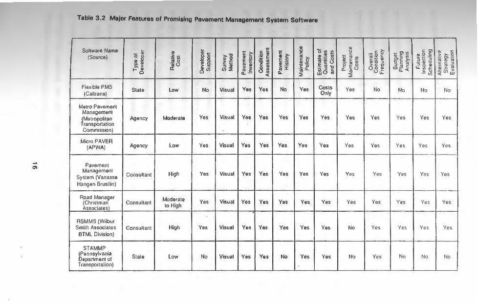
generally cost more and require an annual or periodic support fees. Table 3.2 lists the
seven programs and also shows a comparison of their major features.
The quality of the data management components depended on the limitations of the
database manager used in its development. Most of the packages were deficient in terms
of file flexibility, especially those which used input and output file coding other than the
American Standard Code for Information Interchange (ASCII). ASCII files contain
standard text characters which may be read by different computer operating systems, and
appear in a readable form when displayed on the screen. The degree of output flexibility
was fairly standard among the programs; in most of the packages, specific information can
be generated by selecting the appropriate options, and then the reports can be sent to a
disk file, screen or printer. The data analysis methods of most of the programs were
very similar. A numeric pavement condition index or rating is derived from the quantity
and severity of pavement distress. The distress data and pavement condition index are
then used in other analysis routines within the program.
Most of the programs allowed both network and project level analyses, although some
of the programs included capabilities for only one level of analysis. All seven of the
packages were suitable for municipal use, but only a few appeared adaptable for site
specific modifications at a future time.
15
m
Table 3.2 Major Features of Promising Pavement Management System Software
Sollware Name (Source)
Flexible PMS (Callrans)
Melro Pavement Management (Metropolitan r ransportatron Commission)
Micro PAVER (APWA)
Pavement Management
System (Vanasse Hangen Brustlin)
Road Manager (Christman Associateil
RSMMS (Wilbur Smilh Associates
BTML Division)
STAMMP (Pennsylvania Department ol Transportation)
- Q; 0 a. Q) .Q a. Q) >- > f- Q)
0
State
Agency
Agency
Consultant
Consultant
Consullant
State
Q)
-~ u; ro o
Qj () a:
Low
Moderate
Low
High
Moderate to High
High
Low
Qi e B- 8. Q) a. > ::i ~ (/)
No
Yes
Yes
Yes
Yes
Yes
No
>- "U Q) 0 2: -5 ::i Q)
(/) ::2
Visual
Visual
Visual
c 2:-Q) 0 E c Q) Q) > > ro c:
Cl. -
Yes
Yes
Yes
c: c :~ E "U Ul c: Ul
8 m <(
Yes
Yes
Yes
Visual I Yes I Yes
Visual I Yes I Yes
Visual I Yes I Yes
Visual I Yes I Yes
c Q) 2:' E o Q) iii > ·-ro :r:
Cl.
No
Yes
Yes
Yes
Yes
Yes
No
Q)
g ro c: (J' Ql · -c 0 ·n; Cl.
::2
Yes
Yes
Yes
Yes
Yes
Yes
Yes
0 U') U')
Q) .!!! iii n; ·~ 0 E c: o ·- ro -u u; :::> c w 0 ro
Costs Only
Yes
Yes
Yes
Yes
Yes
Yes
Q) u
- c: ~ ro ui
·- ~ Vi Q c 0
Cl. 'iii 0 :2
Yes
Yes
Yes
Yes
Yes
No
No
- g () ~ :~ ~ Q) "U ::> > c: cr 0 0 Q) ou:
No
Yes
Yes
Yes
Yes
Yes
Ye s
0\"' a; c iii °'c ~ -u c: ro :i ro c
ro a: <I:
No
Yes
Yes
Yes
Yes
Yes
No
c 0\ Q) Q '= :Ju :; - a> ·o ::i a. Q)
lL "' ..c c u - (/)
No
Yes
Yes
Yes
Ye s
Yes
No
Q) c > >- 0 ;:: 0\ ;:: ro a> ro c - ::i .._ tO -a> ~ ro ;:{iii ~
No
Yes
YC!s
Yes
Yes
YC!S
No
3.3 Selection of Micro PAVER Computer Program
The pavement management system evaluation process identified several excellent
microcomputer-based programs. Some useful functions were unique to certain programs;
thus no single program included all the necessary capabilities of the ideal pavement
management system. The features of Micro PAVER, however, distinguish it as the most
appropriate PMS software for Rhode Island municipalities.
Micro PAVER is one of the simplest menu-driven microcomputer-based programs
which features an objective and repeatable visual distress survey methodology. Since it
was developed by a government agency, Micro PAVER is non-proprietary and does not
require any development costs. Continuous support is provided by the American Public
Works Association (APWA) and periodic updates are furnished to its users. In October
1989, Micro Paver Version 2.1 was released. · Accordingly, Micro PAVER is one of the
most widely utilized programs; more than 110 users are organized as a non-profit user
group to assist each other and facilitate program updates ( 7).
The Micro PAVER system provides the user with a practical decision approach for
identifying cost-effective maintenance strategies for roads and streets. Interface programs
of Micro PAVER provide report generation capabilities for critical information which allows
objective input to the decision-making process. Other important capabilities include data
storage and retrieval, pavement network definition, pavement condition index (PCl)/rating
(PCR), project prioritization, inspection scheduling, determination of present and future
network condition, determination of needs for maintenance and repair (M & R),
performance of economic analysis, and budget planning (B,9, 10, 11 & 12).
3.4 Development of a Prototype PMS for Municipal Maintained Roads In Rhode Island
During the evaluation process of available microcomputer based pavement
management systems, two pilot networks were created: the Kingston campus of the
University of Rhode Island (URI) and the Town of South Kingstown (TSK). The roadway
17

system of the URI campus was established to investigate the adaptability of promising
computer programs to an actual street layout and to develop a prototype PMS for Rhode
Island municipal-maintained roads.
3.4.1 Development of Guidelines for Data Collection
Before data can be collected, a municipality must first identify its pavement network
components. A zone is the largest subdivision within a network. Zone boundaries are
usually defined by permanent or physical obstructions (such as natural/semi-natural
barriers, state/major local roads), or less commonly, by administrative divisions (such as
voting wards or school districts). A branch is any identifiable part of the network that is
a single entity and has distinct function, such as an individual street. Ideally, each branch
should be contained in one individual zone, but occasionally, branches may be
components of two or more zones.
Sections are those portions of branches which are uniform in pavement structure ·
composition, traffic, construction history, pavement rank, drainage facilities and shoulders.
Other factors to be considered in defining sections include management, data availability,
costs, and whether section limits can be changed. Since no formal length restrictions are
imposed on sections, a branch may consist of a single section. For example, minor
residential streets and dead end roads typically have identical characteristics throughout,
and therefore consist of only one section. Sample units are the smallest component of
the network. The sample is the portion of the section which is actually inspected;
therefore the sample(s) must be a representative of the entire section. For sections with
asphalt surfaces, the sample unit(s) consist of 2500 ± 1000 square feet (250 ± 100 square meters).
Accurate section PCl's are essential to both network and project level decisions.
However, inspection of every sample unit within a pavement section would involve
considerable time and effort. Such a practice would require more manpower, funds and
time than are available in most municipalities. Since sections have been defined as
having common characteristics (including surface type, structure, maintenance history,
18

traffic conditions, and about the same level of deterioration), statistical extrapolation is
applied to reduce the collection effort of distress data. Thus, only selected sample units
are inspected and the PCI for the entire section is extrapolated. For initial network
implementation, a ten percent sampling level should be sufficient as shown in Table 3.3.
Figure 3.1 shows a typical application of sections and sample units for a branch. The first
and last sample units of a section are not usually inspected since they may include
pavement characteristics of the intersection.
A municipality should select its sampling level according to the desired level of
accuracy. Since additional sampling can always be performed in the future, a
community's first-time sampling needs could be underestimated without jeopardizing this
previously collected data. All subsequent inspections should always include the previously
surveyed samples. Periodic inspection of the same sample unit assures the -repeatability
and reproducibility of the PCI methodology and also yields a more accurate deterioration
rate for the pavement section.
3.4.2 Development of a Prototype PMS on Piiot Network
The URI Kingston campus features a roadway network similar to most municipalities
in the state, but only at a smaller scale. The roadways on the campus are primarily two
lane streets with asphalt concrete surfaces with functional classifications ranging from
service roads to circulators (Heavily traveled).
The URI network was used for training of municipal personnel and as a pilot network
( 13 & 14). This pilot network was also utilized in examining the repeatability (technically
reproducibility) of the procedure. The network will serve as a standard for calibration of
condition surveys and continuous evaluation of the prototype Micro PAVER PMS.
The URI is a medium-size state university with its main campus located in the rural
village of Kingston in southern Rhode Island. The campus is representative of a
19

Table 3.3 Recommended Sampling Strategy for the Prototype Micro PAVER PMS
Number of Sample Units per Section
1 - 10
11 - 20
21 - 30
31 - 40
Recommended Sample(s) to Inspect (if representative)
2nd
2nd, 12th
2nd, 12th, 22nd
2nd, 12th, 22nd, 32nd
20

UPPER COLLEGE ROAD (BRANCH No. 10220)
3347' (1020 m)
Key
I 001 l = Section No.
= Sample Unit No. Surveyed
NOTTO SCALE
Figure 3.1 A Typical Branch/Section/Sample Unit Application
21

suburban area; the highway network generally consists of two-lane asphalt concrete
surfaced roadways which are functionally classified as circulator, access, or service roads
(Table 3.4). On-street parking and sidewalks are present on some streets in the network.
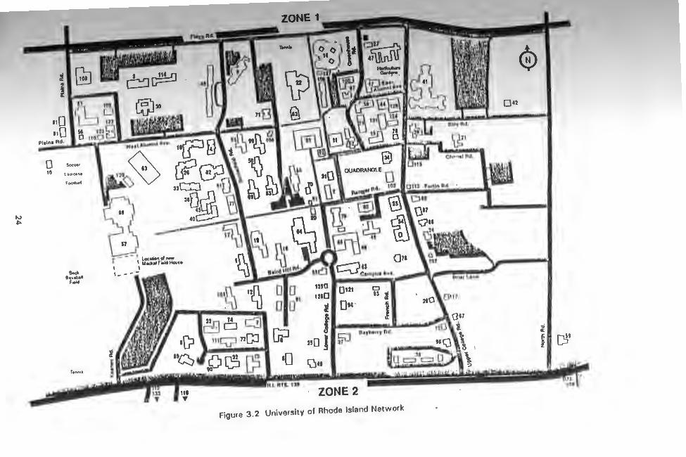
The URI campus network is divided into two zones as shown in Figure 3.2. The zone
boundaries were established by using Route 138, which divides the main campus from
other URI facilities.
The pavement condition surveys were performed with the developed guidelines in the
summer of 1988 and spring of 1989 by two different survey crews, with supervision of a
research assistant. In 1988, the survey was done by TSK personnel as part of a training
exercise in data collection and pavement evaluation procedures. In 1989, the survey was
performed by civil engineering students in the highway engineering and pavement
management classes, as a training exercise in pavement management data collection.
The use of different survey parties provides a test of Micro PAVER PMS for repeatability.
Branch inspections and data collection were performed either from west to east, or
south to north. Branch numbers were sequentially assigned to an alphabetized list of the
branches. Pavement sections were based on the structural composition or surface type.
A twenty percent sampling level was used and the inspected sample units were
representative of .the entire section. Crews of two or three people recorded the quantity
and severity of nineteen types of visual distress.
The results of the network level inspections using the developed guideline showed a
fair pavement condition, with an average PCI of 52. However, more than half of the total
network area (51.3 percent) has a PCI of 55 or better.
The repeatability of the PCI procedure was analyzed by comparing the condition data
for the five branches which had been surveyed in both years. Both sample and section
PCl's were used in this process. The analysis revealed the importance of inspecting the
same sample units each time the branch is surveyed; more accurate
22

Table 3.4 University of Rhode Island Branch Information
NUMBER
BRANCH BRANCH FUNCTIONAL BRANCH OF
NUMBER BRANCH NAME USE CLASSIFICATION AREA {SF) SECTIONS
10010 Alumni Ave. East Roadway Circulator 23 ,505 3
10020 Alumni Ave . West Roadway Circulator 50,996 2
10030 Baird Hill Road Roadway Circulator 23 ,1 00
10040 Butterfield Road Roadway Circulator 46,696 2
10050 Chafee Road Roadway Access 19,551
10060 Davis Road Roadway Service 13,522 2
10070 Faculty Apt. Cir. Roadway Access 29,200 1
10080 Farmhouse Road Roadway Access 11,550
10090 Flagg Road Roadway Circulator 186,680 2
10100 Fraternity Circle Roadway Access 53,525 5
10110 Grad. Viii. East Roadway Access 19,250
10120 Grad. Viii West Roadway Access 19,251 1
10130 Greenhouse Road Roadway Access 21,855 3
10140 Heatham Road Roadway Access 23,790 1
10150 Keaney Road Roadway Access 21 ,781
10160 Lippitt Road Roadway Service 5,900 2
10170 Lower College Rd. Roadway Circulator 45,382 3
10180 Peckham Farm Road Roadway Access 12,240
10190 Powerhouse Road Roadway Service 9,600 1
10200 Quarry Road Roadway Access 7,410
10210 Ranger Road Roadway Service 26,104 2
10220 Upper College Rd. Roadway Circulator 85,518 _g Totals 774,152 39
23
"' ~
~ : i ir l a ,
110 110
(1 109
L=J c;; Plain• Rd .
55 1230 o 1100B
wut f<lumnl ,. •• •
0 Socoo•
10 l •oms•
football
-Bauball f•ld - _ .... .....__ . ..._ - 010 "'" 0"' o
11 mo u .i
0 0 ~ OM · i CB t:i QI' J . 1119 nGJ [f.J 1 SJ Beyberry Rd.
. 2sO ,,
ler1n1t ·1:::. •O i;:i .. ~ . ~ ;;.·r;HIH-·+•• . - ~· ~· arLwnrnrr a•mar DI All= '111
ZONE 2
Figure 3 .2 University of Rhode Island Network
® ou
,; a:
~I CS9
z

section deterioration rates may be determined and discrepancies between samples may
be avoided.
The sample PCI correlation between the two different survey crews was reasonable .
The PCI deviation ranged from an increase of 14 to a decrease of 24, but
the average PCI of a sample decreased by 2.5 points between the two surveys. Table
3.5 summarizes the PCI data for all compatible samples. The section PCI correlation
between the two different survey cres was also reasonable. The PCI deviation ranged
from an increase of 7 to a decrease of 10, but the average PCI of a section decreased
by 1.5 points between the two surveys. Table 3.6 summarizes the section PCI
comparison. This analysis shows that the PCI methodology of Micro PAVER is both
repeatable. The procedure itself protects against unreasonable observed samples, and
additional samples may have to be inspected.
An overall PCI frequency report was generated to determine future network conditions
and to help establishing future network maintenance and repair (M & A) needs. The
impact of performing no major repairs shows the average network PCI will deteriorate from
52 to 41 over a six-year period (Figure 3.3). Similarly, Table 3.7 shows the estimated
frequency of occurrence for the same set of pavement sections for the analysis years
assuming no major repairs (such as overlay) have occurred between the last inspection
date and the prediction date.
One of the most important attributes of the implementation system was a preliminary
list of M & A techniques and costs for both project and network level management. The
most feasible M & A alternatives were developed (Table 3.8) based on the results of the
evaluation of the pavement condition, current university maintenance practices and
performance standards. The ranking of feasible M & R alternatives for any pavement se r · c ion is based on the impact of the alternative on future pavement performance and the
associated costs. The list will be used as a guide until another list is developed.
25

Table 3.5 Sample PCI Comparison
SECTION/ PCI RATING
SAMPLE SUMMER SPRING BRAN!:;H NAME NUMBER ..llfili.. 1989 DEVIATION
Baird Hill Road 001/002 46 43 3
001/006 21 35 -14
Butterfield Road 001 /001 10 5 5
0021002 8 6 2
Flagg Road 001/002 77 67 10
001/007 82 90 -8
001/012 93 85 8
001/017 98 100 -2
001 /022 96 91 5
001/002 77 63 14
002/006 37 32 5
002/012 77 79 -2
002/015 48 45 3
Greenhouse Road 001/002 54 52 ' 2
002/001 87 63 24
Keaney Road 001 /002 70 65 5
002/008 74 68 6
Lower College Road 001 /001 67 74 -7
002/003 78 74 4
002/006 59 68 -9
Upper College Road 001 /002 31 11 20
001/008 19 20 _,
002/002 65 72 -7
002/007 37 42 -5
AVERAGE PCI DEVIATION = 2.5
26

Table 3.6 Section PCI Comparison
PCI RATING
SECTION SUMMER SPRING BRANCH NAME NUMBER 1988 1989 DEVIATION
Baird Hill Road 001 33 39 -6
Butterfield Road 001 14 5 9
Flagg Road 001 90 87 3
002 59 54 5
Greenhouse Road 001 55 52 3
Keaney Road 001 72 66 6
Lower College Road 001 67 74 -7
002 64 66 -2
Upper College Road 001 25 15 10
002 51 57 -6
27

PREDICTED NETWORK PCI
70
60
so I 40 ~ 30 ~
I
201 1a 1
I
52
45 43 41 ------
of--~-L~~....l__~~~~-+-~~-+--~~-l---~___J~~____J
1988 1989 1990 1991 1992 1993 1994 1995 1996
YEAR
Figure 3.3 Predicted Network PCI
28

Table 3.7 Annual Network Deterioration Projections
Number of Sections YEAR
PCI RANGE 1989 1990 1991 1992 1993 1994 1995
0 - 10 2 4 4 7 7 8
11 - 25 7 6 4 5 2 2 2
26 - 40 4 8 8 8 10 10 10
41 - 55 9 7 7 7 5 5 6
56 - 70 10 8 8 9 10 10 9
71 - 85 5 5 6 4 3 4 4
86 - 100 4 4 3 3 3 2 2
Percent of Area YEAR
PCI RANGE 1989 1990 1991 1992 1993 1994 1995
0 - 10 2.5 6.2 12.4 12.4 18.2 18.2 19.1
11 - 25 16.6 13.0 6.7 9.3 3.6 3.6 2.6
26 - 40 12.1 14.9 14.9 14.9 23.2 23.2 23.2
41 - 55 17.5 21.8 21.8 20.8 12.5 12.5 13.6
56 - 70 23 . .6 16.5 16.5 20.5 21.5 21.5 20.5
71 - 85 8.4 18.4 26.1 20.5 19.6 19.9 19.9
86 - 100 19.2 19.2 1.5 1.5 1.5 1.2 1.2
29

Table 3.8 M & R Strategies and Unit Costs for Network-Level PMS {Asphalt Concrete)
PCI Range M & R Strategy Cost , $/SY. Cost , $/SF
0 - 20 Reconstruction or Recycling 12.00 1.33
21 - 40 Overlay {thick. may vary with PCI) 10.00 1.11
41 - 60 Stone Sealing (Surface Treatment) 8.00 0.89
61 - 80 Minor Repair 7.00 0.78
81 - 100 Routine Maintenance 3.00 0.33
·Note: Adjusted 1988 Costs ( 11)
30

The criteria for establishing priorities for pavement sections requiring routine
maintenance are different from those used for sections needing essential repair or
rehabilitation. Major maintenance or reconstruction of the pavement surface will bring the
road surface back to its original "as-constructed" condition. The length of time between
major maintenance operations will depend on the type of road surface. Major
maintenance includes the correction of the pavement surface with an asphalt overlay or
surface treatments. Routine maintenance includes the correction the correction of
pavement distress as it occurs rather than at specified periods of time after construction .
This type of maintenance includes patching with both temporary and permanent seals
such as fog seals, sand seals, or slurry seals. M & A priorities for sections requiring
routine maintenance are a function of the individual distress type and the severity of the
distress. The distresses which have a large effect on the operational condition of the
pavement are given highest priority.
The primary input for routine network level M & A analysis is the type, severity and
amount of distress. Table 3.9 summarizes M & A alternatives for asphalt concrete
pavement distress types ( 15). Priorities for sections requiring major M & A should be
based on the PCI and the functional classification. In addition to predicting pavement
performance for various M & A alternatives, valuable input to life cycle costs, budgeting,
and planning is also provided. Typical total network M & A costs expected for the
strategies used on the URI campus are summarized as follows:
reconstruction or recycling
asphalt overlay
surface treatment
$ 163,684
$ 76,893
$ 215,551
minor repair $ 129,341
routine maintenance $ 51,585
These costs were determined based on the present PCI, and are expressed in 1988 dollars.
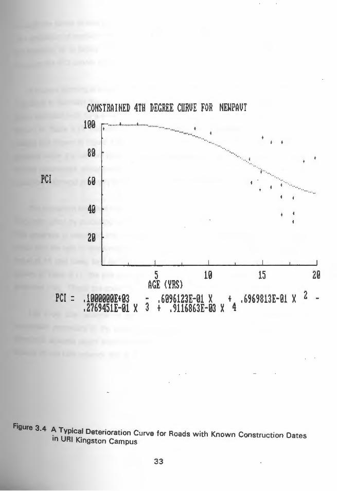
The other important feature is the deterioration curve developed as a pavement condition model f th . . . . or e network (Figure 3.4). This model includes a best fit curve
31

w N
Table 3.9 Asphalt Concrete Pavement Distress Types and Routine M & R Alternatives
~ Apply Apply
Do Creek P11tl1I Full
Skin Pothol1 HHt Sur11ce Nothing s ... . Depth Depth
Pitch Fllllng & Roll SHI Pitch Pitch
S1nd Emulslon e
1 Alligator M,H M,H l 2 Bleeding L L,M,H
3 Block L Cracking
4 Bumps & L M,H M,H M,H Sags
5 Corrugation L M,H M,H
6 Depression L M,H M,H M,H 7 Edge Cracking L L,M M.H" M,H•
8 Joint L L,M,H H Reflective Cracking
9 Lane: L Shoulder Drop·ofl
10 Longtudinal L L,M,H H L Transverse Cracking
11 Patching & L M H" H" Utility Cut
12 Polished A Aggregate
13 Potholes L L,M,H LM,H 14 Railroad L L,M,H
Crossing
15 Rutting L L,M,H M,H L,M,H
16 Shoving L M,H
17 Slippage L l M,H Cracking
18 Sell L M,H
19 Weathering & L H Raveling
Note: L = Low Severity; M = medium severify; H"' fiigh severity.
Apply Apply Aggre-
Reluve· gate NOTES nation Seal
Coat
L
L L,M
'Apply Shoulder seal, e.g., agg.
seal coal
M,H· 'Level ott shoulder & apply
agg. seal coat L L.M
• replace patch
A
L M,H
CONSTRAINED 4TH DEGREE CURUE FOR NEWPAUT 100 ....................... .............................. ..
······ .. .... .... ••, , I I ·· ..
80 "• ...... " ... +
"·
PCI 60 I . + "· ....
+ +
40 + +
20
5 10 15 AGE (YRS)
PCI : .1000000E+03 - .6096123E-01 X + .6969813E-01 X .2769451E-01 X 3 + .9116863E-03 X 4
....
2Q
2 -
F' igure 3.4 A Typical Deterioration Curve for Roads with Known Construction Dates
in URI Kingston Campus
33

through the family of data points representing all sections less than twenty years of age.
The prediction of section condition assumes that the behavior of the section is similar to
the behavior of its family. The curve has been constrained to eliminate positive slope,
because the PCI cannot increase with age.
A budget planning analysis was performed using the developed M & R strategies and
unit costs to estimate the annual rehabilitation required to maintain pavements above a
given condition level for a six-year period. Using the pavement condition repair schedule
shown in Table 3.10 and assuming a five-percent annual inflation rate produces the
budget plot shown in Figure 3.5. At the end of a six-year period, 24 of the 40 pavement
sections within the network would have been repaired at a total cost of $538,200. Based
on the parameters established in Table 3.10, the overall condition within the network
would be improved gradually by 1994, having an average section PCI of 55.
The inspection schedule report is used to maintain current condition data with efficient
inspection effort by producing a six-year schedule of pavement sections to be surveyed.
The schedule is based on the minimum PCI that a given pavement type is allowed to
reach and the rate of deterioration (loss of PCI points per year). Using a minimum PCI
value of 41 (the lower limit for fair pavement condition) and the deterioration schedule
shown in Table 3: 11, the plot and section list of inspection schedule report have been
produced { 10). These are shown in Figures 3.6 and Table 3.12 respectively.
Life cycle cost analysis of pavement maintenance alternatives is a proven and
acceptable procedure in the process of selecting the preferred alternative. A typical
economic analysis report outlining several feasible repair alternatives was applied to a
branch on the URI network, this is shown in Table 3.13.
34
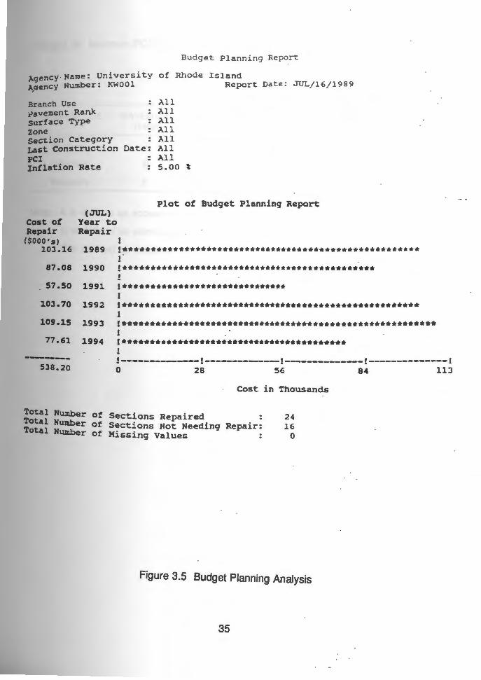
Budget Planning Repo!L
Agency Name: Univers ity of Rhode Island A~ency Number: KWOOl Report Date : JUL/ 16/1989
Branch Use a>avement Rank surface Type zone section Category Last Construction Date:
>.11 >.11 >.11 >.11 All All All 5.00 t
PCI Inflation Rate
Plot of Budget Planning Report (JUL)
Cost of Year to Repair Repair
C$000's) 103.16 1989
87.08 1990
57.50 1991
103.70 1992
109.15 1993
77.61 1994
-----538.20
!******************************************************
!********************************************** ! !****************************** 1 !****************************************************** l !********************************************************* 1 '*****************************************
!------------~1----~--~---1--------------r~------------1 0 28 56 84 113
Cost in Thousands
Total Humber of Sections Repaired 24 Total Number of 5 . ections Not Needing Repair: 16 Total Humber of Missing Values O
Figure 3.5 Budget Planning Analysis
35

Table 3.10 Minimum PCI Repair Schedule
Year of Repair/Minimum Allowable PCI
BRANCH USE PAVEMENT 1989 RANK
Roadway A 15
Roadway B 15
Roadway c 15
Note: A is defined as access roads
B is defined as service roads; and
C is defined as circulator roads
1990 1991 1992 1993
25 35 40 45
25 35 40 45
25 35 40 45
36
1994
55
55
55

Table 3.11 Rate of Deterioration for Inspection Scheduling
RATE OF DETERIORATION (PCI POINTS PER YEAR)
>9
6 to 9
2 to 9
<2
RE INSPECTION INTERVAL (YEARS)
37
2
3
4

Figure 3.6 Plot of Inspection Schedule Report
Agency Name: University of Rhode Island Report Date: JU1'1/29/l989
Branch Use All pavement Rank All surface Type All Zone All Section Category All Last Construction Date: All PCI All
Number of sections
Year to Inspect
l l
Plot of Inspection Schedule Report
16 1990 !••···················-·························· 0 1991
4 1992
20 1993
0 1994
0 1995
---------40
l l ! ! l
!•••········· ! !
!*********************•······································
!-----~-------!--------------!--~----------!--------------! 0 5 10 15 20
Number of Sections
Total Number of Sections to Inspect Total Number of Sections Not Heeding Inspection:
40 0 0 Total Humber of Hissing Values
38

Table 3.12 Section List for Inspection Schedule Report
Inspection Schedule Report
Age nc y Narne: Uni ver s ity o f Rhode Island Report Date : JUN /29/19 8 9
Sect i o n Lis t o f Inspection Schedu l e Repo rt
Year to Branch Section Inspect Num I Name I Use Nu:m jRank/ Surf/ >.rea ( SF) ------- ----------------------------------------- -------------------------1990 10010 /ALUMNI AVENUE EAST / ROADWAY 001 I c I AC I 3675 1990 10020 /ALUMNI AVENUE WEST / ROADWAY 001 I c I AC I 43670 1990 10030 /BAIRO HILL ROAD I ROADWAY 001 I c I AC I 23100 1990 10040 /BUTTERFIELD ROAD / ROADWAY 001 I c I .AC I 18976 1990 10040 /BUTTERFIELD ROAD /ROADWAY 002 I c I AC I 27720 1990 10050 /CHAFEE ROAD / ROADWAY 001 I .A I .AC I 19551 1990 10070 /FACULTY APARTMENT CIRCLE / ROADWAY 001 I A I AC I 29200 1990 10080 /FARMHOUSE ROAD / ROADWAY 001 I A I AC I 11550 1990 10100 /FRATERNITY CIRCLE / ROADWAY 001 I A I AC I 14775 1990 10100 /FRATERNITY CIRCLE I ROADWAY 003 I A I AC I 6424 1990 10100 /FRATERNITY CIRCLE I ROADWAY 004 I A I AC I 5790 1990 10160 /LIPPITT ROAD / ROADWAY 002 I B I MC I 2800 1990 10170 /LOWER COLLEGE ROAD I ROADWAY 003 I c I AC I 5832 1990 10200 /QUARRY ROAD / ROADWAY 001 I A I AC I 7410 1990 10210 /RANGER ROAD /ROADWAY 001 I B I MC I 4862 1990 10220 /UPPER COLLEGE ROAD / ROADWAY 001 I c I AC I 32400 1992 10010 /ALUMNI AVENUE EAST I ROADWAY 002 I c I MC I 2592 1992 10090 /FLAGG ROAD I ROADWAY 002 I c I AC I 52800 1992 10110 /GRADUATE VILLAGE EAST / ROADWAY 001 I A I AC I 19250 1992 10120 /GRADUATE VII.LAGE WEST / ROADWAY 001 I A . I AC I 19521 1993 10010 /ALUMNI AVENUE EAST / ROADWAY 003 I c I AC I 17238 1993 10020 /ALUMNI AVENUE WEST / ROADWAY 002 I c I AC I 7326 1993 10060 /DAVIS ROAD / ROADWAY 001 I B I MC I 2542 1993 10060 /DAVIS ROAD / ROADWAY 002 I B I MC I 10980 1993 10090 /FLAGG ROAD I ROADWAY 001 I c I AC I 133880 1993 10100 /FRATERNITY CIRCLE I ROADWAY 002 I A I AC I 15136 1993 10100 /FRATERNITY CIRCLE / ROADWAY 005 I A I AC I 11400 1993 10130 /GREENHOUSE ROAD / ROADWAY 001 I A I AC I 7750 1993 10130 /GREENHOUSE ROAD / ROADWAY 002 I A I AC I 7781 1993 10130 /GREENHOUSE ROAD / ROADWAY 003 I A I AC I 6324 1993 10140 /HEATHMAN ROAD / ROADWAY 01 I A I AC I 23790 1993 10150 /KEANEY ROAD / ROADWAY 001 I A I AC I 21781 1993 10160 /LIPPITT ROAD / ROADWAY 001 I B I MC I 3100 1993 10170 /LOWER COLLEGE ROAD / ROADWAY 001 I c I AC I 7300 1993 10170 /LOWER COLLEGE ROAD / ROADWAY 002 I c I AC I 32250 1993 10180 /PECKHAM FARM ROAD / ROADWAY 001 I A I AC I 12240 1993 10190 /POWERHOUSE ROAD / ROADW>.Y 001 I B I MC I 9600 1993 10210 /RANGER ROAD / RO>.OW>.Y 002 I B I MC I 21242 1993 10220 /UPPER COLLEGE ROAD / ROADWAY 002 I c I AC I 34398 1993 10220 /UPPER COLLEGE ROAD / ROADWAY 003 I c I AC I 18720
Total Humber Of Sections to Inspect 40 Total Humber Of Sections Hot Needing Inspection: 0 Total Humber of Mi ssing Values 0
39

Table 3.13 Typical Economic Analysis Report
DhTE:= AUG / 14 / 19 89 PROJECTED COST ANALYSIS ( D!:TAE )
SECTI ON ID:=BUTTE.RFIEL ALTERNATIVE:= RECONSTRUCTION SECTION AR EA(S . Y.):= 5190 . C
LIFE OF ALTERNATIVE:= 20 Ih'TEREST RATE:= 1 0 . 0 IN FLATION RATE:= 5.0
M&R ACTIVITY YEAR
RECONSTRUCTION 1989 PAINT LANE MARKERS 1989
ANNUAL TOTAL:"'
ROUTINE MAINTENANCE PAINT LANE MARKERS ROUTINE MAINTENANCE
1991 1992 1993
PAINT LANE MARKERS 1995 ROUTINE MAINTENANCE 1995
ANNUAL TOTAL: ..
ROUTINE MAINTENANCE PAINT LANE MARKERS ROUTINE MAINTENANCE
1997 1998 1999
PAINT LANE MARKERS 2001 ROUTINE MAINTENANCE 2001
ANNUAL TOTAL:-=
ROUTINE. MAINTENANCE PAINT LANE MARKERs
ROt.rrINE MAINTENANCE
2003 2004 2005
PAINT LANE MARKERS 2007 ROUTINE MAINTENANCE 2007
ANNUAL TOTAL:=
INITIAL COST($):= PREsENT VALUE($):c EQUIVALENT UNIFORM ANNUAL EUAC PER SQ. YD. ($):=
40
COST(S ) PRESENT VALUE($ )
62280.00 600.00
62880.00
62280.00 600.00
62880.00
1560.00 "600.00
1560.00
600.00 1560.00 2160.00
1560.00 600.00
1560.00
600.00 1560.00 2160.00
. 1560.00 600.00
1560.00
600.00 1560.00 2160.00
COST($):-=
62880.00 74225.96 8718.55
l.68
1421.40 521.84
l.295.12
453.87 1180.06 16JJ.9J
1075.22 394.75 979.69
343.33 892.65
l.235.98
BlJ.35 298 . 61 741 09
259. 71 675.25 934.96

CHAPTER 4. IMPLEMENTATION OF THE PROTOTYPE PMS IN A TYPICAL TOWN
The larger road network of the Town of South Kingstown (TSK) was instituted to test
the suitability of the developed prototype PMS in a typical community, and also to develop
additional municipal implementation.
The TSK, encompasses 62.3 square miles in mostly rural Washington County, in
Rhode Island. In addition to its primary attribute as a rural residential town, TSK serves
as the commercial hub for much of the southern Rhode Island region.
Approximately 400 miles of roadway are located within TSK's borders. The Town is
responsible for maintaining 125 of these miles of roadway. The municipal average for the
state is 130 miles. This fact, combined with the proximity of the TSK to the University of
Rhode Island, and the presence of both urban and rural areas within the township, made
it the ideal municipality for pilot implementation of the developed Micro PAVER PMS.
The TSK is governed by a Town Manager and a five member Town Council. The
Director of Public Works reports to these elected officials. The South Kingstown
Department of Public Works (DPW) is divided into three divisions: Engineering, Highway,
and Maintenance. The Engineering Division is responsible for the implementation of the
pavement management system. The Engineering Division is headed by a professional
engineer, and has one non-registered engineer, two engineering technicians, one
construction inspector and one clerical person. The Division also employs interns,
typically engineering students during the summer months. The PMS is currently
administered by one full-time engineering technician, with assistance from the intern,
under the supervision of the engineers. The engineering technician does have other
duties and responsibilities not directly related to the pavement management system.
The TSK began implementation of the prototype Micro PAVER PMS in June, 1988. D .
unng the first month of implementation, the standardized URI Kingston campus road
network was used to train the Town's engineering technician and a Public Works Intern in the data II .
co ect1on and computer entry procedures of Micro PAVER. In July, 1988, an
41

appropriate pavement management network structure was developed for the Town based
on the developed guidelines. The network structure comprised of a zone layout and,
branch and section numbering strategy.
4.1 Network Development and Data Collection
The network development and data collection effort was aided by the "Street
Inventory," and an in-house computer file of construction and major maintenance
activities. The "Street Inventory", a document maintained by the Engineering Division,
identifies the limits (location), right-of-way length and width, road ownership/maintenance
status (town, private or state), and other pertinent information for all 575 named roads
within the Town's borders ( 16). Table 4.1 shows part of the Inventory file. The
construction and major maintenance file is arranged in a similar format and includes data
fields for the road width and length, the classification type (Principal Arterial, Minor Arterial,
Collector, Local, or Private}, the construction or major maintenance activity, and the last
service date. However, the construction and maintenance records are not as complete
as the "Street Inventory."
The pavement management network was divided in eight zones (Figure 4.1 }, using
permanent or physical obstructions (such as natural/semi-natural barriers, or state/major
local roads). Branch numbers were assigned to the roads using five numeric characters
(numbers), the first character being the zone number, and the second, third, and fourth
characters are consecutive, sequential numbers assigned to an alphabetized list of the
branches (roads). The fifth character accommodates for future branches. Appendix B
shows the branch list report for the Town. Pavement sections were based on structural
composition or surface type, with section lengths of 500 feet and a forty percent sampling
rate. The inspection and data collection was performed in directions west to east, and south to north.
42

""" (,)
Table 4.1 Partial Listing of the Street Inventory File
STREET NAME & AREA LOCATION
Eagle Nest Terrace From Dendron Road north to dead end (Peace Dale)
East Farm Road From Kings t own Road east to dead end (Kingston)
Eastern View Avenue From Border Avenue north to Hilltop (Green Hill) Avenue
Easy Street From Hunt Avenue north then west to (Wakefield) Gregory St reet
Edgewater Road From Hillcrest Road north to Silver (Wakef ieldJ Lake Avenue
Edgewood Farm Road From Post Road at the top of Sugar (Wakef ieldJ Loaf Hill south to private R.O .W.
past Stoneway Road
Edwards Avenue From Middlebridge Road east to dead IMiddlebridge) e nd . (Nor t h of Torry Road)
Eisenhower Place From MacArthur Boulevard to Pershing (Wakef ieldJ Aven ue
Elderberry Lane From Gent i an Drive east to dead end (Peace Dale)
Eldred Court From Kenyon Avenue west to Sunset (Wakef ieldJ Avenue
Source: Street Inventory, Town of South Kingstown Notes:
ROW
MAP WIDTH LENGTH FT FT
F-8 so 364.8
D-7 970.!.
M-2 40 660
F-7 40 S30
G-7 40 1040
G-7 1930
D-10 30 631
G-8 so 813
F-6 so 2SS.!,
G-7 32 583 . 19
Road Status: T =Town Roads, P =Private Roads, S =State Roads
E
ROAD DATE ST . NO . & STAT ACCEPTED REFERENCES RANGE
T 4/10178 P81 6/ 1J7 0-71 1- 34 LEll S/ 52) TC38/7 7
s 1-97
T 4/14/69 PB9/659 1- 7 6 TC32/194
p PB13/939 1-52
T 3/10/41 PBl 017 08 1- 106 3/10/49 LE4 9/S 30
TC22
p LE35/ 498 1- 1)0
T 12/lS/75 LE43 /3 80 1- 50 LEJ 20/239
T 11/27 I 61 PB8/59 1 1-78 PBI0/715 - 16 PB13/ 1015 TC31/440
T 1/817 9 PB16/1430 - 40 1-2 0 TC39!) 4
T 12/8/52 PB12 /90 1B 1-57 LESO / 130 TC26/22
Reference Code Description: PB = Plan Book, TC = Town Council Book, LE = Land Evidence Book, SH = State Highway Book, LE = Land Evidence Book, SH State Highway Book, OB = Old Book of Highways

\ ______ _ TOWN OF SOUTH KINGSTOWN - - - :...... Zone Boundary
Q or Q State Highway ' I
6 WROP
.. :~ -I
/'1" 2 ----- I
""/ URI ~ l 1----.. ----~ G ' 7 ..faos ~ ------;
I _., I I ,_.- , ~-~ / I 8 I I I
I WKFL I -
/
' ( I
. { I I I I I
II J_ 9'/
.. 1 West Kingston
2 Univ. of RI
------r- ~ 4 . 1 5 J MTNK
GRNH I
3 Middlebridge
4 Matunuck
5 Green Hill
6 Worden's Pond
7 Peace Dale
8 Wakefield
Figure 4 1 p . · · avement Management Zone Structure for the Town of South Kingstown
44

The pavement condition surveys were performed during a one year period as shown
in Figure 4.2. Approximately ten hours per week were expended in the field for the
collection of condition data.
4.2 summary of Existing Conditions
The Micro Paver Pavement Condition Index (PCI) Report was used to analyze the
existing conditions of the towns roadways (Appendix C). The majority of the town
maintained paved roads in TSK are in good condition with an average PCI rating of 61.
As shown in Figure 4.3, sixty-two percent (sixty-five percent of the area) of the paved
roadway sections are In good condition or better. The average pavement condition for the
eight zones in the Town (Table 4.2), shows the zone pavement condition ratings to be
good, with PCI ratings varying between 56 and 69. As shown in Table 4.3 the pavement
condition data was compared by section category, pavement rank and surface type. The.
comparison of the data for pavement rank shows, the PCI to be 68 for secondary
roadways, 66 for primary roadways and 58 for tertiary roadways, which makes up
approximately seventy-one percent of the total sections (forty-three percent of the total
network area). The comparison between different surface types shows an average PCI
of 68 for asphalt concrete pavements, 55 for asphalt concrete overlay and 57 for stone
seal pavements.
4.3 Maintenance and Repair Policy
The annual maintenance and repair (M & R) requirements consists of activities for
preventive and safety maintenance and repair. Preventive maintenance and repair
consists of localized or global maintenance activities that slow deterioration rate to
preserve the pavement investment. Localized preventive maintenance includes crack
sealing and various patching techniques. Global preventive maintenance includes various methods of rt . su ace sealing for asphalt concrete pavements. Safety M & R involves pothole pat h" c rng and lane shoulder drop-off leveling ( 10).
45

110
100
100
90
90
80 80
70 (/J
70 c 0
:;:::;
UJ 60 c
60 () Q)
en 0 -u Q) 50 en
0 50 -c
(]) - () 0 ... 40 Q)
~
40 (])
a.. .c E ~ 30 z
(])
30 > ~ :J
20 20 E :J
(.)
10 10
0 0 ~ M ~ ~ ~ ~ ~ ~ ~ ~ ~ - ~ M
1988 1989
Im · Number of Sections -+- Cumulative Percent
Figure 4.2. Network Inspection Schedule for the Town of South Kingstown
46

c 0 -1) c 0 0
Foiled
0 5 10 15 Percent of Total
I 12l83 Sections llHI Areo
20 25 30
Figure 4.3. Average Pavement Condition for the Town of South Kingstown
47

Table 4.2 Pavement Condition of South Kingstown Roadways by Zone
Number Percent Area of of x 1000 Percent
Zone Name Sections Sections sq. ft . Area ·pc1
1 West Kingston 31 7.5 1,255 8.9 69
2 University of Rhode Island 27 6.6 843 6.0 59
3 Middlebridge 18 4.4 639 4.5 69
4 Matunuck 51 12.4 2,221 15.8 60
5 Green Hill 41 10.0 1,408 10.0 56
6 Worden's Pond 11 2.7 883 6.2 64
7 Peacedale 63 15.3 2,394 17.0 59
8 Wakefield 169 41.1 4,456 31.6 60
'PCI Report, September 1989
48

Table 4.3 Pavement Condition by Section Category, Pavement Rank and Surface Type
Number Percent Area of of x 1000 Percent
Sections Sections sq. ft. Area "PCI
Section Category
Urban 261 63.5 7,528 53.4 59 Rural 150 36.5 6,572 46.6 63
Pavement Rank"
Primary 56 13.6 4,622 32.8 66 Secondary 65 15.8 3,386 24.0 68 Tertiary 290 70.6 6,091 43.2 58
Surface Type
Asphalt Concrete 134 32.6 3,452 24.5 68
Asphalt Concrete 41 10.0 745 5.3 55 Overlay
Stone Seal 234 56.9 9,899 70.2 57
Other(bridge 2 0.5 4 NIA deck surfaces)
"September 1989 ~A= Not Applicable (Wooden Bridge Deck) Pavement Rank:
Primary includes Principal Arterials and Minor Arterials Secondary includes Collectors Tertiary includes Local or Private Roads
49

The TSK's current maintenance and repair policy (Table 4.4), uses patching for
localized preventive maintenance and safety M & R ( 17). The global preventive
maintenance is performed using stone seal (surface treatment), asphalt concrete overlays
or reconstruction. The global preventive maintenance is developed as part of the road
improvement program which is prepared annually as part of the six year work program.
The Road Improvement Program is a six year outline of the estimated costs and
scheduling of the proposed projects ( 18). The projects are classified according to four
categories:
1) Asphalt Paving Element: This element identifies Town-owned and maintained
highways that cannot be maintained by the conventional stone seal program. It
includes major a·rteries, town or urban type roads, and other roads that do not meet
the physical requirements for stone seal;
2) Reconstruction Element: This program provides road reconstruction by a private
contractor. These roads can no longer be maintained by stone sealing or asphalt
paving program. The problems are structural deterioration of the road surface
caused t;>y a combination of poor road base, weight or heavy traffic volumes;
3) Road Upgrading Element: This program provides upgrading of the Towns road
system with gravel surface. Once a year, these roads are leveled and graded. The
budget provides an annual amount for road building materials and equipment to
implement this program;
4) Road Hazard Correction: This program is used to improve roadway hazards such as
sight distances, alleviating vertical and horizontal curves, and other similar localized
repairs.
Individual road improvement projects are specifically identified for the most important
jobs, otherwise the general area is listed. Based on the experience of the town engineer,
judgements as to which maintenance and repair policy (treatments) is based on a
combination of the following elements:
The reasons for deterioration of a particular pavement section, such reasons could
be poor drainage, bad aggregates, poor construction, or inadequate design of existing structure.
Past success or failures observed over time.
50

Table 4.4 Maintenance and Repair Policy for the Town of South Kingstown ( 17)
Maintenance and Repair Policy
Localized Preventive Maintenance and Safety M & R
Patching
Global Preventive Maintenance
Stone Sealing
1 % inch Asphalt Concrete Overlay
3 inch Asphalt Concrete Overlay
Reconstruction
0
1989 Base Year Costs
51
Cost Per Sq. ft ($)°
.62
.13
.30
.59
1.65

Historical records or observations whereby certain treatments have
consistently outperformed others or conversely exhibited certain problems
after maintenance rehabilitation, or reconstruction.
The priorities tor routine maintenance activities are assigned by the
Maintenance Division primarily on a complaint/response basis. The TSK does not
currently use the prototype Micro PAVER PMS for selection of roads for
maintenance and repair. However, the PCI report was used to justify projects for
the 1990-91 Road Improvement Program.
4.4 Development of Deterioration Prediction Curves
In order to analyze life cycle for construction practices used by the Town,
family prediction analysis was performed using in Micro PAVER. The pavement
sections having common characteristics such as pavement type were grouped into
families. This was done to develop deterioration prediction curves for stone seal
pavements and asphalt concrete pavements. These equations are used to predict
the pavement life. Pavement life is the actual number of years in service, starting
from the year of construction or rehabilitation, for a pavement section to
accumulate the predetermined threshold value of distress points. For a newly
constructed pavement section, the life is assumed to be equal to the design life.
The actual pavement life could be shorter (the threshold value of distress is
reached in a shorter time period than the expected design life) or longer (the
threshold value of distress is reached in a longer period than the expected design
life) than the design life. The prediction model in Micro PAVER is based on
polynomial regression. The fourth degree constrained equations are:
Stone Seal Pavements
PCI = 100 - 4.441 x - 1.533 x2 + .212 x' - .0073 x4 (1)
Asphalt Concrete Pavements
PCI = 100 - 8.833 x + .580 x2 - .0154 x3 + .000123 x4 (2)
x = number of years
52

Based on the prediction curves developed, the average pavement life was
determined from the points of deterioration changes on the curve. The constrained
prediction curve for stone seal pavements (Figure 4.4) shows the average life to
be between six and eleven years while that for asphalt concrete pavements
(Figure 4.5) is between thirteen and twenty-three years. These deterioration rates
are based on the visual inspection of pavement distresses and pavement types.
Due to environmental conditions and structural base, these deterioration rates may
vary for unique pavement types. These deterioration rates agree with other
engineering studies on pavement surface deterioration ( 19,20 & 21).
The deterioration curves can be used 1 ) to assess and understand the impact
of rehabilitation strategy on the health of the pavement network, 2) examine the
pavement design methods and the impacts of the various design and construction
variables on pavement performance, and 3) produce prioritization lists of various
uniform sections of the network. An additional aspect of the deterioration curves
is the potential for statistical analysis of the pavement performance trends.
4.5 Budget Development for the Road Improvement Program
The funding for TSK's individual street improvement projects is requested by
the Director of Public Works on an annual basis through a general road
improvement program. Annual projects are not finalized until the Town Manager
and the Town Council approve a budget allocation. The budget for routine
maintenance activities is established as part of the annual operating budget and
is funded from general revenues.
With the data currently collected for the entire network, the Engineering
Division used Micro PAVER for development and justification of projects for the
1990-1991 Road Improvement Program.
53

PCI
CONSTRAINED 4TH DEGREE CURUE FOR STDATA 100 . I
t .... t + + +j
80
60
29
++ . .. + I + + \ ..... + t + ! + ! +
+ " + + + ! + + + · · ~ i ! +
+ + ++f~ "'1+. + t •. +' +; + i+ +
+ ++ + +k.' ; • + ++ + + ++ ··.... I i + + + + + * .. , i • + 1 + + ...... + +
' + : + ........ . ' ..... + + + i• ...... .............................. . + ........
+ + + t ".
+ + • + I i + + +
5 19 15 AGE <YRS)
20
PCI : .1000000E+03 .2115846E+00 X
- .4411498E+91 X - .1533111E+01 X 2 + 3 - .7262657E-92 X 4
Figure 4.4 Deterioration Prediction Curve for Stone Seal Pavements
54

PCI
CONSTRAINED 4TH DEGREE CURUE FOR ACDATP.
100 · ~· * 1 + i. + +
' 1 +
80 •\ .. . ; "· + • + + + + t"1 •+ *•
·+·· ... + .... • • * •,T +
+ . '""4"·.\.~. + + + + 60
• •
.... , .......................................................... . + + • • ....... .
20
+ t+ ........ , + \ + {
+ + • +
•
++
•• + +
5 10 AGE <YRS>
15 20 25 30
PCI : .1000000E+03 - .8833328E+01 X + .5803534E+00 X 2 -.1535828E-01 X 3 + .1229361E-03 X 4
Figure 4.5. Deterioration Prediction Curve for Asphalt Concrete Pavements
55

Before the implementation of Micro PAVER, the selection of individual projects was based
on factors such as available funds, citizen complaints, political considerations, utility
information and future development plans, these still play a role in determining the final
project list. The 1990-91 budgets were developed using the Micro PAVER developed
PCl's and other physical roadway deficiencies (such as drainage conditions and safety).
The budget estimates ( 18) for the 1990-1991 Road Improvement Program (Tables
4.5) allocates $290,000 for the first year, and $1,885,000 for the six years, this is
developed based on the four categories discussed under Maintenance and Repair
Policies. The Road Sealing Program which is developed as part of the operating budget
only includes projects on an annual basis, the estimated budget (Table 4.6) for this
program is $177,000, while the budget estimate for construction materials needed for
routine maintenance is $91,000.
56

Table 4.5 Six Year (1990-1991) Road Improvement Program
First Year Cost - $290,000 Six Year Cost - $1,885,000
Asphalt Paving Element ($80,000)
Square Project Programmed Fiscal
Location 1PCI Yards Cost ($) Cost($) Year
Allens Avenue 11 6,000 30,000 30,000 90-91 Moonstone Beach Rd. (Route 1 -Matunuck School House) 39 14,300 50,000 90-91 South Road (Route 138-RR track) 47 17,200 70,000 120,000 91-92 Moonstone Beach Rd, (Matunuck School House - Card's Pond) 58 4,300 20,000 20,000 91-92 Green Hill Beach Rd. (Matunuck School - Ocean) 58 14,000 60,000 105,000 92-93 Rodman St. 64 10,500 45,000 92-93 Middlebridge Rd. (Radial - Town line) 65 28,000 120,000 120,000 93-94 North Rd. (Route 108 - Fiore) 65 5,800 30,000 100,000 94-95 Matunuck Beach Rd. (Ocean -Carpenter's Stand) 66 15,300 70,000 94-95 Green Hill Beach Rd. (Route 1 -School House) 67 12,000 50,000 130,000 95-96 South Rd. (RR - Curtis Corner) 68 10,000 40,000 95-96 Rose Hill Rd. (Route 138 - Brook) 70 10,000 40,000 95-96
Reconstruction Element {$100,000)
Location 1PCI Phase Footage Programmed Fiscal Year Cost $
Matunuck School House Road 32 II 1,000 100,000 1990-91
Matunuck School House Road 32 Ill 1,000 100,000 1991-92 Green Hill Beach Road 58 II 1,000 100,000 1992-93 Broad Rock Road 16 1,000 100,000 1993-94 Torrey Road2 83 1,000 100,000 1994-95 Torre~ Road2 83 II 1,000 100,000 1995-96
Total 6,000 600,000 l~1
== Pavement Condrt1on Index ad and Drainage Improvements
57

Table 4.5 Six Year (1990-1991) Road Improvement Program continued
Road Reconstruction Element {$50,000}
Location Programmed Cost {$}
Fiscal Year
Amancio Street. Eastern View Avenue 50,000 1990-91
Border Avenue 50,000 1991-92
Kingston Area 50,000 1992-93
• Matunuck Area 50,000 1993-94
West Kingston Area 50,000 1994-95
East Matunuck Area 50,000 1995-96
Total 300,000
Road Hazard Correction {$60,000}
Location Phase PCI Cost($) Fiscal Year
Saugatucket at Broad Rock Road3 100 60,000 1990-91
Shannock Road I 53 60,000 1991-92
Saugatucket Road II 100 60,000 1992-93
Plains Road II 43 60,000 1993-94
Green Hill Beach Road 111 58 60,000 1994-95 Torre~ Road 50 60,000 1995-96
Total 360,000 3
Requested by the Traffic Commission
58

Table 4 .6 Road Sealing Program
1990-1991 Maintenance Budget: $177 ,000
Length Width Area Total Location/Street Name PCI (Feet) {Feet) (Sg. Yds) Cost ($)
Item A: Stone Sealing Program
WAKEFIELD 49 415 23 1061 1230 :atudobOn bnve
MacArthur Boulevard 68 1945 22 4754 5515 Eisenhower Place 2-8 825 23 2108 2446 Pershing Avenue 2-47 1213 23 3100 3596 Narragansett Avenue East 35 1625 36 4694 5446 Narragansett Avenue West 33 1253 22 3063 3553 Border Avenue 78 776 26 2242 2600 River Street 3-44 1640 32 5831 6764 Northup Street 26 505 24 1347 1562 Whitford Street 58 1540 28 4791 5558 GeorQe Street 59 465 18 930 1079 Highvrew Avenue 44 250 25 694 806 Hunt Avenue 1-71 1240 25 3722 4318 Hunt Avenue 2-62 920 16 1636 1897 Gr~ry Street 2-38 495 24 1430 1659 Ro land Street 79 765 26 2210 2564 Old Mountain Road 38 1435 21 3348 3884 Smith Street 0 520 23 1329 1542 Liberty Street 3 532 23 1360 1577 Victory Street 7 775 25 2153 2497 School Lane 213 21 497 577 Tucker Avenue 11 480 25 1333 1546 School Street 43 210 22 513 595
SUB TOTAL 54,1 46 62,811
PEACE DALE Church street 4-56 2692 26 7777 9021 Branch Street 24 630 21 1470 1705 Steven Circle 47 303 21 707 820 Rose Circle 53 266 21 621 720 Sprin~ Street 38 1105 25 3069 3561 Prke treet 0 545 25 1514 1756 Gould Street 47 775 25 2153 2497 Harrison Avenue 62 475 24 1267 1469 Austin Street 72 1280 25 3556 4124 Stedman Court 23 440 20 978 1134 Schaeffer Street 60 711 27 2133 2474 Nye Street 31 340 18 680 789 Drxon Street 0 535 17 1011 1172 Rodman Street 64 3094 24 8251 9571 George Schaeffer Street 15 1280 22 3129 3630 Dam Street 29 1465 20 3256 3776 Hopkins Lane 356' 45 477 15 795 922
59

Table 4 .6 Road Sealing Program continued
Length Width Area Total Location/Street Name PCI (Feet} {Feet) {Sg. Yds) Cost ·($}
PEACE DALE continued 5 730 18 1460 Green Street 1694
Larkin Street 350 18 700 812 Kersey Road 20 1480 28 4604 5341 Amos Street 33 490 25 1361 1579 Oak Dell Street 44 1517 24 4045 4693 Fagan Court 40 470 25 1306 1515 Kimball Street 3 240 21 560 650 Brown Street 34 445 22 1088 1262 Indian Run Road 36 540 22 1320 1531
SUB TOTAL 58,811 68,218
GREEN HILL Shannock Road 8266 21 19287 22373 Gravelly Hill Road West End 4180 22 10218 11853
SUB TOTAL 29,505 34,226
hem B: Sand Sealing
Little Rest Road 47 2226 22 5441 6312 Parkwood Drive 6 1947 23 4976 5772 Marion Road 17 937 21 2186 2536 Thistledown Road 12 415 19 876 1016 Mark Glen Court 33 354 23 905 1050
SUB TOTAL 14,384 16,686
GRAND TOTAL ITEM A & B 156,846 181,941
60

.CHAPTER 5. INTEGRATION OF A PROTOTYPE PMS FOR MUNICIPAL
MAINTAINED ROADS WITH A GIS
5.1 Concepts of a Geographic Information System
A Geographic Information System (GIS} is a data model that involves storage of
tabular data (attributes} in association with simple cartographic features (points, lines, and
polygons}. Cartographic data are stored not as graphics primitives or symbols but as
tables in non-symbolized form that stands in relation to other attributes. While similar to
Computer Aided Drafting (CAD} approach in its use of coordinates, the data model for this
technology is fundamentally different in its simplicity and approach. It provides the use
of topology to store relationship among spatial objects. A CAD system differs from a GIS
in that it typically has a more developed set of procedures to create an manipulate
graphical objects, but does not deduce and store information about relationship between
objects ( 1 & 2). The CAD database model treats spatial information as electronic
drawings made up of graphics features organized into layers. CAD does not create, or
store topology. A CAD drawing of a highway can thus be viewed as a database of the
lowest drawing elements that it is required to store or create a representation of the
highway ( 1 & 2).
A GIS can be used as a tool for automated drafting, simple storage, and regeneration
of graphics and plots of information maintained in the database. Rather than storing map
features as graphics symbology, the GIS data structure organizes features with descriptive
characteristics. GIS software makes it easy to manage, organize, query, and display large
collections of spatial information. The location information is represented by points,
features such as roads are represented by lines (arcs} and features such as lakes are
represented by areas {polygons}. The PC ARC/INFO version 3.40 GIS was used in
development of the prototype PMS/GIS integration.
61

5.1.1 Description of pc ARC/INFO Software
The software system PC ARC/INFO was developed by the Environmental Systems
Research Institute (ESRI), Redlands, California, a private commercial organization with
an extended development history in mapping and analysis. The PC ARC/INFO is a
vector-based geographic information system with modular design. Among the modules
included with the software are programs for digitizing, interactive editing of graphic and
statistical data, drawing and map production, and management of the attribute database.
The system integrates geographic analysis and modeling capabilities with a fully
interactive system for acquisition, management, and display of spatial data. The PC
ARC/INFO system consist of the following modules (22,23 & 24):
STARTER KIT is used for map creation and digitization, attribute table creation,
topologic data structuring, map plotting and host computer communication. The
STARTER KIT includes the ARC Digitizing System {ADS) to quickly create and edit .
map coverages; CLEAN and BUILD to create point, line and area features from raw
coordinates; and file management program called TABLES (24).
PC ARCEDIT is a sophisticated interactive graphics and database editor. This
module is used to create and modify coverages. PC ARCEDIT combines all the
facilities of the ADS component. It combines capabilities of CAD functions with
capabilities of a geographic database (25).
PC ARCPLOT is used for interactive map creation and display, graphical query, and
the generation of high quality maps. PC ARCPLOT allows the use a macro
programming language, SML {Simple Macro Language), for developing user interface
menus and automation of the cartographic production process (26).
PC OVERLAY is used for topology analysis such as polygon overlay, line and point
in-polygon overlay, and buffer generation. PC OVERLAY contains six overlay
commands {CLIP, ERASE, IDENTITY, INTERSECT, UNION, and UPDATE}, which
are very useful in geographic analysis (27).
The modules described above were used in the PMS/GIS integration. Other pc
ARC/INFO modules are: PCt · .
NFO is a stand-alone fully featured relational database management system
62
PC DATA CONVERSION is used for conversion of vector and grid cell formats to and
from ARC/INFO.
PC NETWORK is used for analytical functions for modeling networks, and performing
optimal routing, districting, address matching, and geocoding.
5.2 Integration of Micro PAVER PMS with PC ARC/INFO GIS
The data integration process required two steps: understanding the data descriptions
for the Micro Paver database, and the data needed for the integration with the GIS
network. The functionality of the process is to bring together separate software
components to enhance or extend the analysis whereby reducing the database
management system duplication. A framework was developed as guide for the integration
process (Figure 5.1 ). This process involves running the Micro PAVER and pc ARC/INFO
independently of each other and using R:BASE System V to export the necessary data
attributes in American Standard Code for Information Interchange (ASCII) format for import
and integration with the roadway network created in pc ARC/INFO. R:BASE System V
was developed by Microrim, Incorporated. It is a database management system for
microcomputers with powerful and flexible capabilities for storing, organizing, analyzing
and retrieving information (27).
5.2.1 Data Conversion In R:BASE SYSTEM V
The Micro PAVER database files ROADINV1 .RBF and ROADINV2.RBF were
converted from the Micro PAVER database format to R:BASE System V database format.
The CONVERT module of R:BASE was used in this process. Three files were created
by the conversion process. At the completion of the conversion process, the data
attributes necessary for the integration process were exported as ASCII files. In Table 5.1
the shaded area shows the different database tables and attributes used. Tables 5.2 and 5
·3 shows the ASCII delimited file SECTION.FIX and BRASCH.FIX.
63

Pavement Management System
I M icroPAVER
r Network Data
Development ... Collection
I
I H Data
Analysis
Data Conversion
RBase
System V
Geographic Information System
PC Arc
J Info
t Network
Development --+ Mapping/
i Analysis
Integration
of Data
Figure 5.1. PMS and GIS Integration Process
64

Table 5.1 Micro PAVER Database Tables in R:BASE
TABLES COLUMNS
system agency, secur, unit, name, add r, ctysta, zipcde, phone, passwrd
XDIST BRANUM, SECNUM, INSDAT, DISCOD, SEV, QUA, DEN, DEDVAL
ii -NDT BRANUM, SECNUM, NDTLOC, NDTDAT, NDTIEM, NDTLOA, MAXDEF, BASARE,
DSM, LOATRA
POLICY1 POLNUM, POLDES
POLICY2 POLNUM, DISCOD, SEV, WORTYP, MATLOD, EXTRA1 , EXTRA2
CONDHIST BRANUM, SECNUM, INSDAT, RIDQUA, SAF, DRAGON, SHOCON, OVECON, FOO, TOTSAM, NUMSAM, PCI, TOTRAN, TOTADD, MINSAM, PCISTA, PDVLOA, PDVCLI, PDVOTH
SAMPLE BRANUM, SECNUM, INSDAT, SAMNUM, SAMTYP, SAMSIZ, SAMPCI, DISCOD, SEV, QUA
WORKHIST BRANUM, SECNUM, WORTYP, DATCOM, MATCOD, THI, MANACC, WORQUA, TOTCOS, WORCOM, STADAT, IDDAT, PRONUM, PHANUM
TRAFFIC BRANUM, SECNUM, SURDAT, AIRTYP, ANNDEP, ADT, PERTRA, PER2AT, PER3AT, ESAL, TRACOM
WORREQ BRANUM, SECNUM, WORTYP, STADAT, IDDAT, PRONUM, PHANUM, MANACC, WORKQUA, TOTCOS, MATCOD, THI, WORCOM
MATPRO BRANUM, SECNUM, LAYER, TESTYP, TESTLOC, TESTVAL, DEPTH, MATCOM
Note: The shaded rows shows attributes that were used in the PMS/GIS integration.
65

Table 5.2. ASCII Delimited Export File (SECTION.FIX) from R:BASE
lOCIO 001 WKNGS AC 59 18 10621982/008/01 1988/008/09 100
10010 002 WKNGS ST 1371 16 219361988/008/01 1988 /00 8 /09 44
10010 003 WKNGS ST 100 14 1400 1982/008/01 1988/008/09 71
10010 004 WKNGS AC 122 28 34161982/008/01 1988 / 008/09 10 0
10010 005 WKNGS ST 532 13 69161982/008/01 1988 /008/09 71
10015 001 WKNGT ST 1044 22 229681984/008/01 1988/007/29 89
10020 001 WKNGS ST 1500 24 360001981/008/01 1989 /008/01 100
10020 002 WKNGS ST 200 22 44001981/008/01 1989 /008 /01 100
10020 003 WKNG S ST 4212 21 884521981/008/01 1989/008/01 100
10020 004 WKNGS x 43 16 6881981/008/0 1 1989/008/0 1 100
10030 001 WKNGT ST 2289 25 572251983/008/01 1988/008/02 71
10040 001 WKNGS ST 2400 25 600001988/008/01 1988 /0 10 /21 84
10040 002 WKNGS ST 1795 27 484651988/008/01 1988 /0 10/21 90
10040 003 WKNGS ST 3797 22 835341983/008/01 1988/011/08 83
10050 001 WKNGT ST 1703 19 323571981/008/01 1989/008/01 100
10050 002 WKNGT ST 4963 19 942971981/008/01 1989/008/01 100
10050 003 WKNGT ST 1700 18 306001981/008/01 1989/008/01 100
10060 001 WKNGS ST 1774 22 390281988/001/01 1988/008/02 75
10080 001 WKNGT ST 1838 16 294081960/001/01 1989/008/01 100
10100 001 WKNGT ST 3020 19 573801984/008/01 1988/008/04 75
10110 001 WKNGS ST 6369 21 1337491988/008/01 1988/011/09 87
10115 001 WKNGT AC 640 21 134401989/006/01 1989/006/16 100
10120 001 WKNGT ST 1311 26 340861960/001/01 1988/008/03 82
10130 001 WKNGT ST 5255 23 1208651984/008/01 1988/008/05 66
10140 001 WKNGS ST 1167 25 291751985/008/01 1988/008/11 7 6
10140 002 WKNGS AC 124 23 2852l985/008/01 1988/008/11 100 10140 003 WKNGS ST 3615 24 867601985/008/01 1988/008/11 84 10140 004 WKNGS AC 41 24 9841985/008/01 1988 / 008/11 100 10140 005 WKNGS AC 50 24 12001985/008/01 1988/008/11 100 10140 006 WKNGS ST 2 407 22 529541985/008/01 1988/008/11 66 10150 001 WKNGT ST 3281 18 590581984/008/01 1988/008/05 86 60010 001 WR DPT ST 1300 18 234001976/007/01 1988/012/06 60 60010 002 WRDPS ST 9549 25 2387251988/008/01 1988/012/06 9 2 60020 001 WR DPS ST 4550 20 910001988/008/01 1988/009/22 68 60030 001 WR DPT ST 2300 17 391001982/008/01 1988/011/29 42 60040 001 WR DPS ST 7941 20 1588201976/007/01 1988/012/06 53 60050 001 WRDPT AC 610 15 91501971/009/01 1988/009/22 42 60060 001 WR DPT ST 675 19 128251984/008/01 1988/009/20 61 60070 001 WR DPT AC 1085 26 282101980/008/01 1988/012/08 90 60080 001 WRDPP ST 200 22 44001986/008/01 1988/011/15 90 60080 002 WRDPP ST 5880 23 1352401986/008/01 1988/011/15 91 60080 003 WRDPP ST 5691 25 1422751988/008/01 1988/011/22 53
66

Table 5.3. ASCII Delimited Export File (BRANCH.FIX) from R:BASE
1001 0 BARBER'S POND ROAD ROADWAY s 34730 1001 5 BLACKBIRD ROAD ROADWAY I 22968 10020 DUG-WAY-BRIDGE ROAD ROADWAY 4 129540 10030 ESTELLE DRIVE ROADWAY 1 57225 10040 FAIRGROUNDS ROAD ROADWAY 3 199800 10050 GLEN ROCK ROAD ROADWAY 3 157254 10060 HUNDRED ACRE POND ROAD ROADWAY 1 39028 10070 HUNDRED ACRE POND RD EAST OTH ER 0 10080 JAMES TRAIL ROADWAY 1 29408 10090 JINGLE VALLEY ROAD OTH ER 0 10100 LAUREL LANE ROADWAY 1 57380 10110 LIBERTY LANE ROADWAY 1 133749 10115 OLD USQUEPAUGH ROAD ROADWAY 1 13440 10120 QUEEN'S RIVER DRIVE ROADWAY 1 34086 10130 SAND TURN ROAD ROADWAY 1 120865 10140 WAITES CORNER ROAD ROADWAY 6 173925 10150 YAWGOO POND ROAD ROADWAY 1 59058 60010 GRAVELLY HILL ROAD ROADWAY 2 262125 60020 LIBERTY LANE ROADWAY 1 91000 60030 MOONSTONE BEACH ROAD ROADWAY 1 39100 60040 SHANNOCK HILL ROAD ROADWAY 2 158820 60050 SHERMAN AVENUE ROADWAY 1 9150 60060 WATSON ROAD ROADWAY 1 12825 60070 WENDY LANE ROADWAY 1 28210 60080 WORDENS POND ROAD ROADWAY 3 28 1915
67

5.2.2 Network Development in pc ARC/INFO
The establishment of a GIS network for the town consisted of developing a
town boundary, pavement management zone boundaries, and a roadway network.
Two zones from the Town of South Kingstown road network were used in integrating
Micro PAVER PMS with the PC ARC/INFO GIS . These zones are the West Kingston
and Wordens Pond zones.
The original maps image were obtained from the Rhode Island Geographic
Information System database of United States Geographic Survey (USGS) maps. The
maps obtained consisted of the Town of South Kingstown's roadway. ne.twork, town
line, rivers, and the State rail lines. Theses coverages are in the Universal Tranverse
Mercator (UTMS) coordinate system. The town line coverage (SKTLS) was then
copied as a new coverage SKZONES. The various coverages i.e., roadway network,
rivers, and rail lines were then each edited in PC ARCEDIT. During the editing, all the
features that made up the pavement management zone boundary were selected and
put into the new coverage SKZONES. The pavement management zone boundary
coverage (SKZONES) were then edited in PC ARCEDIT for overshoots, and then
identification labels were assigned to each polygon, of the different PMS zones. The
coverage was cleaned and built using the PC ARC/INFO Starter Kit routines CLEAN and
BUILD, to create the PMS zone boundary coverage SKZONES. The roadway network
coverage (SKRDS) was then intersected with boundary coverage using the PC
OVERLAY routine INTERSECT. This procedure was done to assign the pavement
management zone numbers to the roadway network. This process created a new
roadway coverage PAVE which has PMS zone numbers attached to all lines (arcs).
The new roadway coverage (PAVE) was then edited in PC ARCED IT, to split
and unsplit the arcs which will identify the pavement management sections. The roads
belonging to the study areas, Wordens Pond and West Kingston were then selected . All r
mes (arcs) on the map representing town maintained roadways within the two study zones h .
were t en assigned their appropriate branch and section numbers. Since the branch a d .
n section numbers are independent in the Micro PAVER .database, the
68

branch and section numbers were combined to form one unique number to represent
the ID assigned to the arcs making up the PMS network. The ID item PAVEIDS is an
eight digit number made up of the five digit branch number and the three digit section
number, e.g., branch number 10080 and section number 001 would have a PAVEID
value equal to 10080001. Once this was completed for all sections in the study, the
coverage was then cleaned and built to create a new coverage PMSRDS. Four new
items were added using the command ADDITEM under the PC ARC/INFO Starter Kit ,
theses items BRANCH, SECNUM, HOLD and TEMPID were used to create a common
attribute for joining the roadway network with pavement data. The attribute data for
the ITEMS BRANUM, SECNUM, HOLD and TEMPID were then calculated for the
PMSRDS.AA T file in TABLES.
5.2.3 Development of Network Attributes
The TABLES database manager under pc ARC/INFO Starter Kit was used to create
templates that forms the attribute data. Three data files : SECTION.DAT, AGE.DAT,
and BRANCH.DAT were created. These data files were created using the DEFINE
command in TABLES. The database name, item name, items width, item type, and
number of decimal places are defined with this command. It is important, that the
database structure for the attributes being defined, correspond to the Micro PAVER
database TABLE exported by R:BASE System V. Table 5.4 shows the Data Structure
in TABLES for the files SECTION.DAT, AGE.DAT, and BRANCH.DAT. The items HOLD
and TEMPID were not part of the TABLES definition in SECTION.DAT file , these two
items were added after the ascii data were imported. The fixed ascii delimited files,
exported from R:BASE System V were then imported into the various database
TABLES using the LOAD command under TABLES. The items HOLD and TEMPID were
then added to the SECTIONS.DAT file using the ADDITEM command under PC
ARC/INFO Starter Kit module. The attribute data for the ITEMS "HOLD and TEMPID"
were then calculated for the SECTION.DAT file in TABLES. Tables 5.5 , 5.6 and 5.7
show Partial listings of the attribute data for SECTION.DAT, AGE.DAT, and
BRANCH.DAT. Once the data structure and the data import was completed, the Arc
Attribute File for the roadway network (PMSRDS.AAT) and the various data tables
69
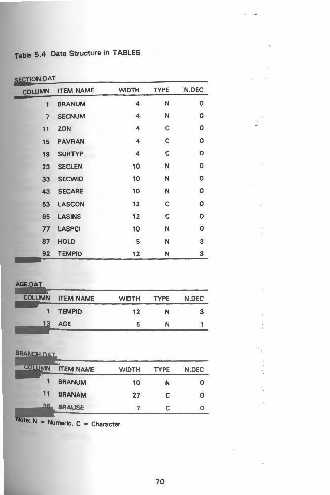
Table 5.4 Data Structure in TABLES
SECTION.DAT
COLUMN ITEM NAME
BRANUM
7 SECNUM
11 ZON
15 PAVRAN
19 SURTYP
23 SECLEN
33 SECWID
43 SE CARE
53 LAS CON
65 LAS INS
77 LAS PC I
87 HOLD
92 TEMPID
AGE.DAT
COLUMN ITEM NAME
TEMPID
13 AGE
BRANCH.DAT
COLUMN ITEM NAME
1 BRANUM
, 1 BRANAM
38 BRAUSE
WIDTH
4
4
4
4
4
10
10
10
12
12
10
5
12
WIDTH
12
5
WIDTH
10
27
7
Note: N - Nu . C - meric, = Character
TYPE
N
N
c c c N
N
N
c c N
N
N
TYPE
N
N
TYPE
N
c c
70
N.DEC
0
0
0
0
0
0
0
0
0
0
0
3
3
N.DEC
3
N.DEC
0
0
0

Table 5.5 Partial List of Attribute Data for SECTION.DAT in TABLES
$REC NO BRANUM 1001 SECNUM 001
ZON WKNG PAVRAN s SURTYP AC SEC LEN 59 SECWID 18 SEC ARE 1062 LASCON 1982/008/01 LAS INS 1988/008/09 LASPCI 100 AGE 6.0 HOLD 0.001 TEMPID 10010.001
$REC NO 2 BRANUM 10010 SECNUM 002 ZON WKNG PAVRAN s SURTYP ST SEC LEN 1371 SECWID 16 SECARE 21936 LASCON 1988/008/01 LAS INS 1988/008/09 LASPCI 44 AGE 0.0 HOLD 0.002 TEMPIO 10010.002
SR EC NO 3 BRANUM 10010 SECNUM 003 ZON WKNG PAVRAN s SURTYP ST SEC LEN 100 SECWIO 14 SECARE 1400 LAS CON 1982/008/01 LAS INS 1988/008/09 LASPCI 71 AGE 6.0 HOLD 0.003 TEMPID 10010.003
71
Table 5.6 Partial List of Attribute Data for AGE.DAT in TABLES
$REC NO TEMP ID AGE
10010.001 6.0
2 10010.002 0.0
3 10010.003 6.0
4 10010.004 6.0
5 10010.005 6.0
6 10015.001 4.0
7 10020.001 8.0
8 10020.002 8.0
9 10020.003 8.0
10 10020.004 8.0
11 10030.001 5.0
12 10040.001 0.2
13 10040.002 0.2
14 10040.003 5.3
15 10050.001 8.0
16 10050.002 8.0
17 10050.003 8.0
18 10060.001 0.6
19 10080.001 29.6
20 10100.001 4.0
21 10110.001 0.3
22 10115.001 0.0
23 10120.001 28.6
72

Table 5.7 List of Attribute Data for BRANCH.DAT in TABLES
$RECNO BRANUM BRANAM BRAUSE
10010 BARBER'POND ROAD ROADWAY
2 10015 BLACKBIRD ROAD ROADWAY
3 10020 DUG-WAY-BRIDGE ROAD ROADWAY
4 10030 ESTELLE DRIVE ROADWAY
5 10040 FAIRGROUNDS ROAD ROADWAY
6 10050 GLEN ROCK ROAD ROADWAY
7 10060 HUNDRED ARCE POND ROAD ROADWAY
8 10070 HUNDRED ARCE POND ROAD EAST OTHER .
9 10080 JAMES TRAIL ROADWAY
10 10090 JINGLE VALLEY ROAD OTHER
11 10100 LAUREL LANE ROADWAY
12 10110 LIBERTY LANE ROADWAY
13 10115 OLD USQUEPAUGH ROAD ROADWAY
14 10120 QUEEN'S RIVER DRIVE ROADWAY
15 10130 SAND TURN ROAD ROADWAY
16 10140 WAITES CORNER ROAD ROADWAY
17 10150 YAWGOO POND ROAD ROADWAY
18 60010 GRAVELLY HILL ROAD ROADWAY
19 60020 LIBERTY LANE ROADWAY
20 60030 MOONSTONE BEACH ROAD ROADWAY
21 60040 SHANNOCK HILL ROAD ROADWAY
22 60050 SHERMAN AVENUE ROADWAY
23 60060 WATSON ROAD ROADWAY
24 60070 WENDY LANE ROADWAY
25 60080 WORDENS POND ROAD ROADWAY
73

developed in TABLES were then joined together using the command JOIN ITEM under the
PC ARC/INFO Starter Kit module.
The attribute data for the AGE.DAT file were joined with the SECTION.DAT file
using TEMP ID attribute, and the attribute data for the BRANCH.DAT file was joined to the
SECTION.DAT file using the attribute BRANUM. Adding attribute about features to a
coverage involves, associating the new information about features with existing records
in the arc attribute table (AAT). The new SECTION.DAT file created from the joining of
AGE.DAT and BRANCH.DAT files were then joined to PMSRDS.AAT using the TEMPID
attribute. Table 5.8 shows the data structure and items for the PMS/GIS integrated
database in TABLES. The shaded area shows the attributes from the original coverage.
5.3 Verification and Map Productlon/Analysls
The verification of the PMS and GIS was accomplished by querying the data in
ARCPLOT and comparing the pavement section data to a 1:1000 scale town map with all
the pavement sections marked on it. Queries such as section number, section length,
pavement types, pavement age, and pavement condition were done. The graphical
queries were also compared to Micro PAVER tabular printouts. The reports used in this
process are the PCI and Inventory Reports.
Once the verification process was complete, simple macros, lookup tables, and title
keys were created to create plots in PC ARCPLOT. Appendix D contains examples of the
simple macro language (SML), lookup tables and key files. The macros were used in
ARCPLOT to create plots for PCI (Figure 5.2), surface type (Figure 5.3), pavement age
(Figure 5.4) and maintenance and repair (Figure 5.5).
74
Table 5.8 PMS Data Structure in TABLES
PMSRDS .AAT
COLUMN ITEM NAME WIDTH TYPE
107 BRANUM 10 N
117 SECNUM 4 N
121 ZON 4 c 125 PAVRAN 4 c 129 SURTYP 4 c 133 SEC LEN 10 N
143 SECWID 10 N
153 SEC ARE 10 N
163 LASCON 12 c 175 LAS INS 12 c 187 LAS PC I 10 N
197 AGE 5 N
202 BRANAM 27 c 229 BRAUSE 7 c 236 TEMPID 12 N
248 HOLD 5 N
N.DEC
0
0
0
0
0
0
0
0
0
0
0
0
0
3
3
Note: The shad d e area shows the attributes from the base coverage.
75
m :11m11
11 'I !Ir"' " a:t
•1111• 11/1 ~ •
n•1 llaJll
I llllltB
IDttlJll WI .
lllf& '...,
Ul.IVllU'& WI
SNOlllONOl 1N3R3AY d
M101S5Nli Hlnos ~o NIOl
9L
I
-

m :1mt1 ll'IU~~"'9'1a:l
11111• 11/1 ~ •
11•1 !lmJil
RIJJJrlll
11In11M3 I llllltil
1'11111111 lM
.-mun [NJ
S3dA1 30V3Hns
MIOlS. HlllOS :lO 001
LL
·- --·--·- - -----.. ------- ·- -.. --·--:---::=---=------·-·---·-·---.. ··- -·--·---·-·--·-._.. -·-·--·-·- · - - _,, .... - - - - ··-' --·-· ..... -···-·-·· ...... _, ··-·-----.--......
~ ~1
/
/
' ,, ", -~
............
' I
I
\ I
I I
I
{
r
I I I
\j \'
I' i
I : :
I
~ I
. I
I --- --- f _ ·_-------_ __:::.=--=--=---=---·----·· -·- --- -- ------- -· .. -------------·----·-·--·--· ·---·-·--·-- ... ··---·-.. ··- .. ·---...... ____ .. __________ -

m :1 m11 lllU~'{8'11'1m
a1111111/1 ~ 11!1
n•1 llaJU
Dl1!1Ilm
IJJlll 'I r--++--- Ill
I llftl II I [NJ
r I l lllU IHI l2I I I ! WI 11111 IH
lllUH Wl
r
I I UNi!li1 I
I
I
mz .. II.ml• lllml a
I m mum t llOISlll IUIS I Ill.I
-- -··"" ~--
,t
// /
,( --~ . -
-... -..... -........ ........
'- .
I ,, r
d 1i .
.I ' I
' I
I
.I . ·I
~ ;1 I I I
(
j
.1
.j '
·1 I' I, 1·
I
!
.1 I

.-------·--
m :a mt1 Ii 'H !Mt 'U,.. 'I lf.l
••11/m~i~
n•• lliDI Jll
111111 J J3ID~
llllllm I lllllUI
UN~!Hl1
A~31 VHlS H t n
1101~1 HlftOS :Kl 1101
6l
I
I
I I
~ .... I i
I
I
__ J
CHAPTER 6. CONCLUSIONS AND RECOMMENDATIONS
The conclusions and recommendations based on the results of this study are
summarized below.
6.1 Conclusions
1) A questionnaire survey revealed that thirty-three of the thirty-nine municipalities in
Rhode Island (eighty-five percent) utilize regular maintenance programs for their
highways; however, the statewide absence of a systematic and rational method to
manage municipally maintained roads .was evident. When this study began, only
one of the communities was using a semi-computerized PMS, a proven technique
to economically administer highway maintenance and rehabilitation.
2) Micro PAVER was selected as the most appropriate microcomputer-based
software for municipally maintained roads in Rhode Island. Micro PAVER is one
of the simplest menu-driven programs which provides users with a practical
decision making tool for identifying cost effective maintenance and repair
alternatives for roads and streets.
3) A prototype PMS was successfully developed for Rhode Island municipal
maintained roads by utilizing Micro PAVER software as the core. Through this
development process several critical functions and procedures were established:
i) a procedure for field crew training;
ii) database to check the reproducibility of pavement condition index (PCI)
values;
iii) guidelines for data collection; and
iv) recommended M & R strategies and unit costs for the prototype Network
level PMS (asphalt concrete). 4) The developed prototype PMS was successfully implemented on trial networks: the
URI Kingston Campus and the Town of South Kingstown (TSK). Through these
initial installations several critical functions were established:
80

i) a standard network (the URI road network) which will allow the future
study, training and calibration;
ii) a model municipal network (TSK) to encourage statewide implementation;
and
iii) a series of deterioration curves for full networks.
5) The deterioration prediction curves for the TSK indicated that stone sealed
pavements have a much shorter average life (six to eleven years) compared to
asphalt concrete (thirteen to twenty-three years).
6) The TSK used implementation results of the prototype PMS in development of
projects for the 1990-1991 Road Improvement Program.
7) Twenty-six Rhode Island municipalities (represented by a total of sixty-two
participants) attended at least one of the pavement management workshops jointly
offered by the Rhode Island Department of Transportation (RIDOT) and URI. At
least sixteen municipalities have decided to implement the developed prototype.
Micro PAVER PMS. Several other communities which expressed little or no
intere~t in a PMS are now recognizing the importance of a systematic and rational
method to maintain their municipal pavements.
8) The integration of the PMS and GIS is a promising development which shows that
the use of graphical queries complements the pavement management process.
The GIS/PMS prototype development addresses procedures and application of the
integration process. The integration process could be complex or straight forward
depending all the PMS attributes, that are integrated.
6.2 Recommendations
1) The URI PMS team should continue to assist all interested municipalities with the
implementation of the developed prototype PMS, and update the list of M & R
strategies, costs and pavement service life of all municipal pavement maintenance
2) practices typically in Rhode Island.
Implementation and research on the Town of South Kingstown model network
should be continued, and all other municipalities should consider utilizing or
adapting the results of this pilot network.
81
3) All systems installed with Micro PAVER 1.0, 1.2 or 2.1 should be upgraded to
Version 3.0 or later.
4) Municipalities should consider incorporating their PMS into a total public works
management system
82
REFERENCES
1. Dangermond, Jack, "CAD vs GIS," Graphics World, October 1986
2. Cowen, David, "GIS versus CAD, What are the Differences?" American Society of Photogrammetry and Remote Sensing, 1988.
3. Peterson, Dale E., "Pavement Management Practices," National Cooperative Highway Research Program Synthesis of Highway Practice No. 135, Transportation Research Board, November, 1987.
4. Carter Associates, Inc., "Pavement Management and Infrastructure Management Systems Brochure," May 1990.
5.
6.
7.
8.
8.
10.
11.
12.
13.
Hass, Ralph and W. Ronald Hudson, Pavement Management Systems, McGrawHill, 1982.
"Microcomputers in Public Works," Special Report No. 52, American Public Works Association, 1986.
Ewing, James W. II, "The Value of PAVER," Better Roads, March 1989.
Micro PAVER Version 1.0 Users Guide, U.S. Army Construction Engineering Research Laboratory, October 1986.
Micro PAVER Users Guide, Version 2.0, U.S. Army Corp of Engineers, Construction Engineering Research Laboratory, September 1988.
Uzarski, D.R. and R.C. Soule, "The Practical Use of PAVER in Planning, Programming and Developing Projects for Pavement Maintenance and Repair," U.S. Army Corp of Engineers, Construction Engineering Research Laboratory, Technical Report M-86/04, March 1986.
Shahin, M.Y. and S.D. Kohn, "Overview of PAVER Pavement Management System," Transportation Research Record 846, 1982.
Kohn, S.D. and M.Y. Shahin, "Economic Analysis of Field Implementation of PAVER Pavement Management System," Transportation Research Record 846, 1982.
Lee, K.W., W.D. Kovacs, B.L. Gray, 0.A. Adeyinka and G.E. Bowen, "A Preliminary Study for Field Crew Training, Standard Network Calibration, and Data Reproducibility to Implement a Pavement Management System for the Town of South Kingstown," Research Report No.1, University of Rhode Island, August 1988.
83

14.
15.
16.
17.
18.
19.
20.
21.
22.
23.
24.
25.
26.
27.
Lee, K.W., W.D. Kovacs, B.L. Gray, 0.A. Adeyinka and G.E. Bowen, "Preliminary Implementation of a Pilot PMS for the University of Rhode Island Kingston Campus," Research Report No.2, University of Rhode Island, September 1988.
Shahin, Mohammed Y., "Components of a Pavement Maintenance Management System," Transportation Research Record 781, 1980.
"Street Inventory Report," Town of South Kingstown, September 1987.
Correspondence with Almond J. Desvoyaux, Assistant Town Engineer, Town of South Kingstown, "Road Maintenance and Rehabilitation Costs," 1989.
"Road Improvement Program for the Fiscal Year 1990 -1991," Town of South Kingstown, December 1989
"Average Comparative Cost of Asphalt Maintenance," Better Roads, page 22, December 1 991 .
"Road Surface Management System," Technology Transfer Center, Department of Civil Engineering, University of New Hampshire, June 1990.
Feighan, Kieran J., M.Y. Shahin, K.C. Sinha and T.D. White," A Prioritization Scheme for the Micro PAVER Pavement Management System," Transportation Research Record 1215, 1989.
"GIS Assessment and Implementation Plan," North Carolina Department of Transportation , Division of Highways, September 1989.
Simkowitz , "GIS in Transportation Planning and Operations, Part One," Public Works, July 1 989
"PC ARC/INFO, Starter Kit, Users Guide," Environmental Systems Research Institute, April 1990.
"PC ARCEDIT I Users Guide, n Environmental Systems Research Institute, April 1990.
"PC ARC PLOT, Users Guide," Environmental Systems Research Institute, April 1990.
Simpson, Alan, Understanding R:BASE System V, SYBEX, 1987.
84

APPENDIX A. DESCRIPTION OF PMS SOFTWARE
85

1.
2.
3.
4.
5.
6.
7.
8.
CANDLINK - Dept. of Civil Engineering, West Virginia University, Morgantown.WV Aids user to decide whether to upgrade/rehabilitate unpaved low volume ro·ad links. the program is interactive. Input requirements include ADTs, surfacing, drainage, geometric design, soils, bridges, etc. Produces list of road links for upgrade or rehabilitation. System requirement are IBM-PC, PC/XT, PC/AT.
CUSTOMIZE - Pavement Management Systems, Denver, CO Customized system to meet agency needs. System requirements are IBM PC, PC/XT; 640K RAM .
FLEXIBLE PMS - FHWA Region 9 Determine the condition of flexible pavements and provides user with ability to reach decisions on which type of reconstruction or rehabilitation is needed. User can adjust distress levels, costs, and priorities and tailor program for lock conditions. The program features user friendly full screen editors to simplify its use. System requirements are IBMPC, PC/XT, PC/AT.
FPMS - CAL TRANS A microcomputer version of the California Flexible Pavement Management System; an inventory and strategy system for evaluation of pavement distress and plotting strategies and priorities for rehabilitation. System requirements are IBM PC compatible; 128K RAM; MS DOS 2.0.
HCPM (Highway Condition Projection Model) - Capital District Transportation Committee, Albany, NY This program projects highway conditions and maintenance costs for up to 99 years into the Mure, given current highway conditions, repair policies, and rates of road deterioration. The model takes the current highway condition scores and checks them against a matrix of repair policies. If a repair is specified, the road is repaired and the cost of the repair along with other pertinent data is saved. If no repair is specified, the road is deteriorated by the yearly amount. System requirements are XENIX; runs on any system with FORTRAN n .
INVENTORY - Bernardin and Associates, Evansville, IN Stores pavement type and width, condition, no. of lanes, shoulder type and width, condition; median type and width, right-of-way width, parking curbs, turn lanes, traffic volume, drainage, land-use characteristics, curve and grade statistics. System requirements are IBM-PM, PC/XT, PC/AT; hard disk required.
LOCAL ROADS FORECASTING MODEL - Metro Area Planning Council , Boston, MA Produces 1 O year forecasts of road conditions and calculates network's maintenance backlog. Input road maintenance construction costs, deterioration rates, annual maintenance expenditures, current road conditions, etc. System requirements are IBM PC, PC/XT, PC/AT; 128K RAM.
LOW-VOLUME ROAD MAINTENANCE - Dept. of Civil Engineering, University, Morgantown, WV Aids in decisions of upgrading unpaved low-volume unpaved road links. Interactive. User answers question re : road usage, road surfacing, drainage, geometric design, soils,
86

9.
10.
11.
12.
13.
14.
bridges. Output is list of rehabilitation candidates. System requirements are Apple II, IBM-PC. .
METRO PAVEMENT MNGT. - Metropolitan Transportation Commission, Oakland, CA Uses R:Base 4000 database to periorm three network level analyses for city and county agencies: preventive maintenance, rehabilitation, and stop-gap measures: utilizes visual survey and seven distress levels. System requirements are IBM PC, PC/XT, PC/AT; 512 RAM; 1 0 MB hard disk.
MICRO PAVER - U.S. Anny Construction Engineering Research Laboratory and American Public Works Association, Chicago, IL Similar to the mainframe PAVER system, Micro PAVER can be used as a tool in pavement management for flexible and rigid pavements such as roads and streets, parking lots, and airfield pavements. The system capabilities include data storage and retrieval, pavement condition prediction, budget planning, inspection scheduling, detennination of maintenance and repair needs and economic analysis. Micro PAVER is based on the Pavement Condition Index (PCI), which is a repeatable, objective rating of pavement condition based on observed distress types. Program identifies streets needing rehabilitatiori and estimates life-cycle costs for various strategies. Includes 6-year budget forecasts, "what-if" scenarios, forecasts future pavement conditions. As additional capabilities and/or technologies become available, the program will be updated. System requirements are IBM PC compatible, 640K RAM; 20 MB hard disk recommended.
PAVEMENT MANAGEMENT SYSTEM - BSI Consultants, Inc., San Diego, CA Features include field inventory program, pavement condition assessments, maintenance rehabilitation programs, priority scheduling, annual budget reports, maintenance history. Integrates with DYNAFLECT testing and destructive sampling. System requirements are IBM-PC, PC/XT, PC/AT; hard disk required.
PAVEMENT MANAGEMENT SYSTEM - Carter Associates, Inc., San Diego, CA Maintenance management program based on inventory data on roadway condition and pennitting policy alternatives, budget scenarios, and priority rating component. System requirements are IBM-PC, PC/XT, PC/AT; hard disk recommended.
PAVEMENT MANAGEMENT SYSTEM - Morrison, Knudsen, Denver, CO Based on dBase Ill; identifies immediate needs for asphalt surfaces only; tracks surface distress year-to-year. System requirements are IBM PC, PC/XT, PC/AT; 512 KRAM; hard disk recommended.
PAVEMENT MANAGEMENT SYSTEM - PMS, Inc. Cambridge, Ontario, Canada The pavement management utilized FORTRAN n programs to analyze and manipulate data, and update data files. The access to the entire system is through a series of screen display menus. There are six levels of menus, with a total of 18 different menus available. The menus range from data entry to report generating menus. Streets are ranked using a composite rating tenned Pavement Quality Index (PQI). The POI is a number from O to ~O that classifies pavement condition from very poor to brand new (excellent). The POI rs a function of three components of three components: Surface Distress Index (SDI), Surface Roughness Index (SRI) and Structural Adequacy Rating (SAR). System requirements are IBM PC XT/AT or PS/2 compatible, PC/MS DOS, 640K RAM, a 20 MB hard disk. Requires dBASE Ill+ database software. .
87

15.
16.
17.
18.
19.
20.
21.
22.
PAVEMENT MANAGEMENT SYSTEM - Tulare County Association of Government, Visalia, CA . This program is an adaptation of a pavement management system originally used by the California Department of Transportation to recommend and prioritize corrective maintenance on flexible pavements. System requirements are IBM PC compatible, MS DOS.
PAVEMENT MANAGEMENT SYSTEM - Vanasse Hangen Brustlin, Inc., Boston, MA The program is customized for particular roadway systems and needs. The program includes budget forecasts and maintenance alternatives to maximize allowable budgets. The system utilizes three separate pavement deterioration curves for local, collector and arterial roadways from which deduct values are assigned for specific distresses and their severity and extent. System requirements are IBM PC or PS/2 compatible.
PAVEMENT MANAGEMENT SYSTEM - Washington Department of Transportation, Olympia, WA Developed from a mainframe system; allows agency-defined maintenance policies; projects future pavement conditions based on current conditions and past data; prioritizes projects and performs life-cycle analyses. System requirements are IBM PA, PC/XT, PC/AT; 512K RAM; hard disk recommended.
PMI PAVEMENT MANAGEMENT SYSTEM - Hanis and Assoc., Concord, CA Flexible, easy-to-run and menu-driven program, can do budgetary planning for 5-year projections, calculates a preventative maintenance program for each segment, adjusts for climatic and structural design data; includes 20 year optimum maintenance program. System requirements are IBM PC, PC/XT, PC/AT; 512K RAM.
PMP - Midwest Pavement Management, St. Paul, MN Customized; written in Turbo Pascal; designed for use by non-engineers and non-computer specialists; uses data from visual survey and Mays Ride Meter; consists of core inventory file and nine connected files. System requirement are IBM PC, PC/XT, PC/AT; 512K RAM; hard disk required.
PMS - Allan Davis & Associates, Norwalk, CT Developed for Trumbull, Connecticut from canned software. Information to develop is available, not the software itself. Only asphalt, has 1-100 rating for prioritizing, stores condition survey data. Life cycle-costs. System requirements are Radio Shack II.
PMS - De Leuw Cather & Co., Gaithersburg, MD User inputs road links and networks, conditions assessment. Among program's key reports: survey of pavement conditions, priority street based on condition distress, proposed improvement strategies, economic analysis, project cost. System requirements are IBM-PC, PC/XT, PC/AT.
PMS-ITRE - The Institute for Transportation Research and Education (an activity of the University of North Carolina), Research Triangle Park, NC PMS-ITRE is used to enter and analyze data collected through ITRE's Pavement Condition Survey. The program is fully menu-driven and allows the user to change maintenance criteria and costs used in the calculations. Standard reports (such as an alphabetical listing
88

of streets/street segments, a priority listing of street/street segment improvements and a maintenance needs summary table) may easily be obtained by the us·er. System requirements are IBM PC compatible , 512K RAM, MS DOS, hard disk preferred.
23. PMS SERIES 10A-10G INFRASTRUCTURE Database MANAGEMENT SERIES -Pavement Management Systems, Inc. Denver, CO PMS Series 1 OA - 1 OG contains the following components : 1 OA Pavement Inventory Database, 1 OB-1 Road Needs Study, 1 OB-2 Minnesota Highway Inventory, 1 OB-3 Highway User's Tax Fund, 10C Complaint System, 10D Accident Reporting System, 10E Peripheral Concrete System, 1 OF Maintenance History System, and 1 OG Bridge Inventory System. system requirements are IBM PC XT/AT or PS/2 compatible, 10-20 MB hard disk, 640K RAM, and dBASE Ill Plus.
24. PMS SERIES 20 ANNUAL MAINTENANCE PROGRAM ANALYSIS - Pavement Management Systems, Inc., Denver, CO PMS Series 20 uses a comprehensive surface distress inventory to analyze the need for routine maintenance, calculate sectional and system costs, identify maintenance strategies, generate material quantities on a sectional and system basis, and estimate man hours. System requirements are IBM PC XT/AT or PS/2 compatible, 10-20 MB hard disk, 640K RAM, and dBase Ill plus.
25. PMS SERIES 30 PAVEMENT MANAGEMENT REHABILITATION PROGRAM - Pavement Management Systems, Inc., Denver, CO
26.
27.
28.
PMS Series 30 anticipates needs for future rehabilitation, by using local performance curves. It is based on surface distress, roughness and/or strength surveys. It generates locally identified rehabilitation strategies and costs based on economic analysis. User modifiable and friendly, it also produces one to ten year budget projections. System requirements are IBM PC XT/AT or PS/2 compatible, 10-20 MB HARD DISK, 640K RAM, and dBase Ill plus.
PMS SERIES 40 PAVEMENT MANAGEMENT FULLY OPTIMIZED REHABILITATION PROGRAM - Pavement Management System, Inc., Denver, CO PMS Series 40 anticipates needs for future rehabilitation, by using marginal analysis to generate to most optimum rehabilitation. It analyzes rehabilitation priorities over a userspecified program period. In addition, it considers the impact of budget levels of performance or quality of the system. Moreover, it generates needs for annual routine maintenance programs, and allows for user modifiable costs and local performance curves. System requirements are IBM PC Xf/AT or PS/2 compatible, 10-2 MB hard disk, 640K RAM, and dBase Ill Plus.
PMS SERIES 50 PROJECT LEVEL REHABILITATION ANALYSIS - Pavement Management Systems, Inc., Denver, CO PMS Series 50 uses comprehensive deflection testing and distress analysis to generate theoretical needs for asphalt overlay thickness at each test station. It is based on specified design life and projected current traffic levels (load factors included). It generates an estimated subgrade modules and CBR or R values, and performs economic analysis on selected rehabilitation strategies. System requirements are IBM PC Xf/AT or PS/2 compatible, 10-20 MB hard disk, 640K RAM, and dBase Ill Plus.
PMS SERIES 60 CUSTOMIZED PAVEMENT MANAGEMENT SYSTEM - Pavement Management Systems, Inc., Denver, CO
89

29.
30.
31.
32.
33.
PMS Series 60 is a totally designed and customized pavement management system. It can include any aspect of the other PMS Series programs, as well as local pavement management needs. It can build upon existing databases and/or systems . System requirements are Can use any agency system in existence or be designed for a new system.
REGIONAL HIGHWAY PLANNING-Capital DistrictTransportation Committee, Albany, NY Projects highway conditions and maintenance costs up to 99 years into future . Takes current highway condition scores and checks them against matrix of repair policies. If repair specified, road, repaired, cost saved. System requirements are IBM-PC, PC/XT, PC/AT.
ROAD MANAGER - Christman Associates, Inc., Chester, CT The Road Manager includes modules for general roadway information, drainage, utility, improvement planning and budgeting, maintaining a repair history, and diagramming roadways. The program allows for custom reports to be generated through a menu driven generator. It allows the user to define index calculations, repair categories, prioritization, budget preparation, and improvement plan. Graphics such as bar charts and line graphs are included. system requirements are IBM PC or PS/2 compatible, PC.MS DOS, 512K RAM, a hard disk, and a 132 Column Printer.
RSM MS (Road and Street Maintenance Management System) - Wilbur Smith Associates, BTML Division, Falls Church, VA The BTML/RSMSS is a road and street maintenance management tool that provides the manager with an inventory of the physical and functional characteristics of each road or street in the transportation network. It allows incorporation of specific performance guidelines which define each projected maintenance activity, applies standardized maintenance procedures; specifies labor, equipment and materials requirements; establishes accepted produceability rates and recommends safety funds based on labor , equipment and materials; and produces reports of work accomplished, accounting for costs and resources used. System requirements are IBM XT/AT compatible, PC/MS DOS 2.0+, 640K RAM, 10 MB hard disk.
RSMS (Road Surface Management System) - Technology Transfer Center, University of New Hampshire, Durham, NH The RSMS is tailored to meet the needs of any city or town. Implementation of the system involves identification of the road network, evaluation of road surface conditions and specification of maintenance practices and associated costs. The program yields multiple reports from which the municipality can select the most appropriate repair strategy. The RSMS uses a laptop computer for all data collection and storage, an electronic digitizing tablet to enter the road surface condition information into the computer and a fifth-wheel odometer to automatically collect mileage information during the road surface condition surveys.
STAMPP (Systematic Technique to Analyze and Monitor Pennsylvania Pavements) -Pennsylvania Department of Transportation, Harrisburg, PA Based on condition survey, assigns treatment based on level of deterioration. Includes Pennsylvania Automated Roadway Information system; traffic, ride quality, and pavement condition; outputs: condition summary report; strategy array matrix. System requirements are IBM PC, PC/XT, PC/AT; 512K RAM.
90

34.
35.
36.
37.
38.
39.
40.
41.
IMS-I - Public Works Software , Inc., Newington, CT . Infrastructure management system for pavement maintenance. Provides pavement
inventory, calculates serviceability indices: and extensive reporting and graphics. system requirements are IBM PC , PC/XT, PC/AT, 512K RAM.
IMS-II - Public Works Software, Inc., Newington, CT Automatically determines maintenance strategies. Analyzes life cycle costs of maintenance alternatives. Links maintenances alternatives with highest benefit/cost ratio for planning ; over-due preventive maintenance reports, equipment inventory list, others. System requirements are IBM PC, PC/XT, PC/AT; 640K RAM .
IMS PAVEMENT MANAGEMENT SYSTEM - Infrastructure Management, Arlington Heights, IL Eight pavement management modules including inventory, condition, factor, priority (by condition and traffic use), rehabilitation (150 strategies) , five year cost/benefit ratio, and five year programs based on performance, etc. System requirements are. IBM-PC, PC/XT, PC/AT; 512K RAM.
INFRACON - Infrastructure Management Consultants, Inc., Arlington Heights, IL PAVER - and Micro PAVER-based applications which integrate data collected with larger infrastructure management databases including mapping/GADD module. System requirements are IBM-PC, PC/XT, PC/AT; 512K RAM (Ref. 81).
MAPCON - McTrans Center, Gainesville, FL Includes several pavement - related programs and provides paths to all the individual programs, enabling the user to access programs for pavement safety, roughness, structural capacity, and to analyze surface conditions. System requirements are IBM-PC, PC/XT, PC/AT; 512K RAM; hard disk recommended.
PUBLIC WORKS MAINTENANCE MANAGEMENT SYSTEM - Burke & Associates, Inc. Aurora, CO The Public Works Maintenance Management System generates plans, budgets, work orders , and work progress reports for street, park, utility and other maintenance work. The program also provides performance and cost information by activity or project, as well as detail and summary data by work location (such as street segment or park) . Easy-to-follow menus enable the user to build the data files and to generate a number of helpful reports. The software also features on-line data entry of work reports that can be integrated with existing payroll, accounting and pavement management systems. System requirements are IBM PC x:r/AT/ or PS/2 compatible, PC/MS DOS, 512K RAM, A 10MB hard disk. Also requires PC INFO database software from Henco, Inc.
ROADWAY MANAGEMENT - Engineering Technology Corp., Rolling Meadows, IL Shares pavement management inventory database with Infrastructure Management Series. Offers planning and historical data by block or control section. System requirements are IBM-PC, PC/XT, PC/AT, 512K RAM, hard disk recommended.
STREET INVENTORY SYSTEM - Hoffman Associates, Rockville, MD !he Street Inventory System is a microcomputer-based system that contains essential information about pavement and other physical features located within street rights-of-way. The program captures, stores and retrieves information such as pavement type, width ,
91

condition, classification, jurisd iction, traffic volume , drainage systems and sidewalks. The system is available either as a stand-alone product or as a module to other public works maintenance systems developed by the company.
42. ARAI 1 (Automated Road Inventory Appl ications, Version 1) - MHM Associates, Inc., South Bend, IN ARAI 1 verifies and creates a road inventory and highway performance database by automatically collecting, compiling, analyzing, and summarizing inventory information covering defined portions of public road system. The program can be used in a mobile computer interfaced with a Distance Measuring Device and collect data for compiling statistics on mileage and surface characteristics of various types of roads, street, structures and other visible fixed points. It can also be used to collect statistics on surface type, width, condition, and type/severity of surface distress. The program can analyze pavement defects and recommend corrective repair strategies. System requirements are IBM PC compatible; 512K RAM, MS-DOS; Hard disk; and 80 column printer.
43. ARAN and PURD - Federal Technical Surveys, Paris, Ontario, Canada Two devices, ARAN (Automatic Road Analyzer) and PURD (Portable Universal Roughness Device) to collect data; provides summaries of surface distress for pavement sections. Outputs graphs, statistical summaries for each section, life cycle costs. System requirements are IBM-PC, PC/XT, PC/AT, DEC Rainbow; 640 KRAM.
44. ARIA 2 (Automated Road Image Analyzer, Version 2) - MHM Associates, Inc., South Bend, IN ARIA 2 can sample video log tape or direct video log of road surface distress recording and process video images to determine crack density or other distresses. The use can analyze one frame (unit) or several thousand units along the length of any road. The units sampled and their condition (distress density) is stored in a database with other pertinent information for pavement management purposes. System requirements are IBM PC compatible, 512K RAM, PC/MS 3.0+; Digitizer, VCR; Graphics Card; 80 Column printer.
45. PAS 1 - Pavedex, Inc., Spokane, WA PAS 1 is a fully automated system that analyzes pavement images, identifies the type of pavement surface deterioration and then quantifies that data. The enhanced images are stored on video tapes and are accessible for data review and condition verification. The image processing software package is compatible with most microcomputer system formats.
92

APPENDIX B. BRANCH LIST REPORT
93

BRANCH LISTING REPORT
Agency Name: SOUTH KINGSTOWN PUBLIC WORKS DEPARTMENT. Agency Number: 00001 Report Date: FEB/24/1992
Branch Number: All Branch use: All Number of Sections: All Branch Area: All
BRANCH NUMBER ------10010 10015 10020 10030 10040 10050 10060 10070 10080 10090 10100 10110 10115 10120 10130 10140 10150 20010 20020 20050 20060 20070 20090 20100 20110 20120 20130 20160 20170 20180 20220 20230 20240 20245 20255 20260 20270 30010 30020 30030 30040 30050 30060 30070 30080 30090 30100
BRANCH NAME
BARBER'S POND ROAD BLACJtBIRD ROAD DUG-WAY-BRIDGE ROAD ESTELLE DRIVE FAIRGROUNDS ROAD GLEN ROCK ROAD BUHDRED ACRE POND ROAD BUHDRED ACRE POND RD EAST JAMES TRAIL JINGLE VALLEY ROAD LAUREL LANE LIBERTY LANE OLD USQUEPAUGH ROAD QUEEN'S RIVER DRIVE SAND TURN ROAD WAITES CORNER ROAD YAWGOO POND ROAD ALTIN ROAD BAYBERRY ROAD BERTH AVENUE BILLS ROAD BRIAR LANE CAMPUS AVENUE CARRIAGE LANE CEDAR CIRCLE CHAPEL WAY DIANE DRIVE FORTIN ROAD FRANK AVENUE FRENCH ROAD OLD NORTH ROAD OLD ROSE BILL ROAD PLAINS ROAD RAILROAD ACCESS ROAD UPPER COLLEGE ROAD STONY FORT ROAD WAITES CORNER ROAD ASH STREET BERGLUND AVENUE BORDER DRIVE COOlt AVENUE EDWARDS AVENUE GRANT AVENUE BAHN AVENUE HARCOURT AVENUE BOLLAND DRIVE HILLSIDE ROAD
94
BRANCH USE
ROADWAY ROADWAY ROADWAY ROADWAY ROADWAY ROADWAY ROADWAY OTHER ROADWAY OTHER ROADWAY ROADWAY ROADWAY ROADWAY ROADWAY ROADWAY ROADWAY ROADWAY ROADWAY ROADWAY ROADWAY ROADWAY ROADWAY ROADWAY ROADWAY ROADWAY ROADWAY ROADWAY ROADWAY ROADWAY ROADWAY ROADWAY ROADWAY ROADWAY ROADWAY ROADWAY ROADWAY OTHER OTHER ROADWAY OTHER OTHER OTHER OTB ER OTHER ROADWAY ROADWAY
BRANCH AREA (SF)
34730.00 22968.00
129540.00 57225.00
199800.00 157254.00 39028.00
.oo 29408.00
.oo 57380.00
133749 .oo 13440.00 34086.00
120865.00 173925.00 59058.00
8272.00 19700.00 3600.00
34200.00 30082.00 25732.00 12600.00 10070.00 27600.00 16380.00 36480.00 26262.00
9400.00 181088.00
22180.00 151164.00 36360.00 39254.00
114095.00 40215.00
.oo
.oo 16008.00
.oo
.oo
.oo
.oo
.oo 18054.00 28581.00
NUMBER OF SECTIONS
5 1 4 1 3 3 1 0 1 0 1 1 1 1 1 6 1 l l l 1 1 1 1 1 1 1 1 1 l 5 3 2 1 1 2 1 0 0 1 0 0 0 0 0 1 1

BRANCH LISTING REPORT
Agency Name: SOUTH Jl:INGSTOWN PUBLIC wons DEPARTMENT. Agency Nwaber1 00001 Report Date: P'EB/24/1992
BRANCH BRANCH NAME BRANCH BRANCH NUMBER MtJMBER USE AREA (SP') OF SECTIONS
------ ------------------------- ------- --------- -----------30110 JOBN STREET OTHER .oo 0 30115 Jl:IMBERLY DRIVE ROADWAY 29640.00 1 30120 Jl:INGSTON AVENUE OTHER .oo 0 30130 LAFAYETT AVENUE OTHER .oo 0 30140 MAPLE STREET OTHER .oo 0 30150 MIDDLEBRIDGE ROAD ROADWAY 325520.00 3
30160 MITCHELL AVENUE OTHER .oo 0 30170 NARRAGANSETT AVENUE ROADWAY 29735.00 1 30180 OAlt CO~ OTHER .oo 0 30190 PECtalAM AVENUE ROADWAY 17250.00 1 30200 PINE COURT ROADWAY 1596.00 1 30210 POLLOCK AVENUE OTHER .oo 0 30220 RAI>IAL DRIVE ROADWAY 4715 .oo 1 30230 RIVER AVENUE 0'1'HER .oo 0 30240 RIVERSIDE DRIVE ROADWAY 48346.00 1 30250 SEAVIEW AVENUE ROADWAY 21064.00 2 30260 SBADBUSH TRAIL ROADWAY 5424.00 1 30270 SUMMIT AVENUE ROADWAY 13040.00 1 30280 TORREY ROAD ROADWAY 72150.00 1 30290 WAJtEP'IELD AVENUE OTHER .oo 0 30300 WALMSLEY LANE ROADWAY 3900.00 1 30310 WilnKAN DRIVE O'n!ER .oo 0 40010 ANTIQUE ROAD 0'1'HER .oo 0 40020 ATLANTIC AVENUE ROADWAY 40530.00 1 40030 ATLANTIC STREET ROADWAY 16236.00 1 40040 BARNEY AVENUE OTHER .oo 0 40050 BASS ROAD ROADWAY 23166.00 2 40060 BLACJCBERRY BILL DRIVE ROADWAY 92893.00 3 40070 BLISS ROAD ROADWAY 24273.00 1 40080 BOW STREET OTHER .oo 0 40090 BREAJCWATER ROAD ROADWAY 38157.00 2 40100 CARDS POND ROAD ROADWAY 139702.00 1 40110 CENTRAL STREET ROADWAY 9216.00 1 40120 CHAPPELL ROAD OTHER .oo 0 40130 CODDINGTON WAY OTHER .oo 0 40140 COMMUNITY DRIVE OTHER .oo 0 40150 COVE STREET ROADWAY 7326.00 1 40160 DAVIS STREET OTHER .oo 0 40170 DORY COURT ROADWAY 8802.00 1 40180 EMILY LANE OTHER .oo 0 40190 GALE DRIVE ROADWAY 32184.00 1 40200 GOOSEBERRY ROAD ROADWAY 113750.00 1 40210 HARTFORD AVENUE ROADWAY 24800.00 1 40220 BEM:BER HOLLOW DRIVE ROADWAY 31044.00 1 40230 BILL ROAD ROADWAY 8109.00 1 40240 BOLD&N ROAD ROADWAY 20420.00 1 40250 BOWARD CIRCLE ROADWAY 7722.00 1 40260 BULL STREET ROADWAY 19656.00 1 40280 LAD AVENUE ROADWAY 40000.00 1 40290 LEEWARD LANE OTHER .oo 0 40300 LOWER FARM ROAD ROADWAY 15813 .oo 1 40310 NARINE ROAD OTHER .oo 0 40320 MATUNUCJI: BEACH ROAD ROADWAY 260303.00 3
95

BRANCH LISTING REPORT
Agency Name: SOUTH ~INGSTOWN PUBLIC WORKS DEPARTMENT. Agency Nwnber: 00001 Report Date: FEB/24/1992
9JtANCB NUMBER ------40325 40330 40340 40350 40360 40370 40380 40390 40400 40410 40420 40430 40440 40450 40460 40470 40480 40490 40500 40510 40520 40530 40540 40550 40560 40570 40580 40590 40600 40610 40620 40630 40640 40650 40660 40670 40680 40690 40700 40710 40720 50010 50020 50030 50040 50050 50060 50070 50080 50090 50100 50110 50120
BRANCH NAME
KATUHUa SCHOOL BOUSE RD. MEADOW STREET NILL POND ROAD MITTENDORF ROAD MOONSTONE BEACH ROAD NINIGRET AVENUE NORTH WEEDEN ROAD OCEAN AVENUE OLD SUCCOTASH ROAD OLIVER DRIVE OSPREY ROAD P~ AVENUE PARTRIDGE LANE PENINSULA ROAD PERRYWINKLE ROAD POINT AVENUE PORT AVENUE POTTER ROAD PROSPECT ROAD SEABREEZE TERRACE SEGAR COURT SHANNON ROAD SHELDON POINT ROAD SBELLDRAltE ROAD SHERMAN ROAD SILVA STREET SOUTH WEEDEN ROAD STEDMAN ROAD SUCCOTASH ROAD SUMMER STREET SYCAMORE LANE TIDAL STREET WAGER LANE WASHINGTON STREET WATER STREET WEST STREET WEST SIDE ROAD WESTCOTE CLOSE WESTCOTE DRIVE WINDSWEPT DRIVE WINDWARD ROAD ASPEN ROAD AUBURN ROAD BALSAM ROAD BAYBERRY AVENUE BEDFORD DRIVE BIRCB ROAD BORDER AVENUE BROWNING STREET CANTERBURY ROAD CARPENTER DRIVE CHARLESTOWN BEACH ROAD COAST GUARD AVENUE
BRAN CB USE
ROADWAY ROADWAY OTHER OTHER ROADWAY O'l'BER ROADWAY ROADWAY ROADWAY ROADWAY ROADWAY ROADWAY OTHER OTHER ROADWAY OTHER OTHER OTHER ROADWAY ROADWAY OTHER OTHER OTHER ROADWAY ROADWAY OTHER ROADWAY O'l'BER OTHER ROADWAY OTHER ROADWAY ROADWAY ROADWAY OTHER ROADWAY ROADWAY OTHER OTHER OTHER O'l'BER ROADWAY ROADWAY ROADWAY O'l'BER ROADWAY ROADWAY OTllER ROADWAY ROADWAY ROADWAY OTHER ROADWAY
96
BRAN CB AREA (SP')
123486.00 15113 .00
.oo
.oo 157208.00
.oo 17871.00 23446.00 53438.00
6972.00 86800.00 30996.00
.oo
.oo 10605.00
.oo
.oo
.oo 47744.00 22950.00
.oo
.oo
.oo 17024.00 17367 .oo
.oo 51425 .oo
.oo
.oo 16320.00
.oo 8775.00 5600.00
44901.00 .oo
13091.00 5886.00
.oo
.oo
.oo
.oo 25231.00 42868.00 62223.00
.oo 36772 .oo 19881.00
.oo 32256.00 46900.00 81660.00
.oo 7568.00
NUMBER OF SECTIONS
1 1 0 0 2 0 1 1 2 1 1 l 0 0 1 0 0 0 1 1 0 0 0 l l 0 1 0 0 l 0 l 1 2 0 1 1 0 0 0 0 1 2 l 0 l 5 0 1 1 1 0 l

BRANCH LISTING REPORT
AgeDCJ Names SOUTH KINGSTOWN PUBLIC WORXS DEPARTMENT. Ag•DCY NWDb•rl 00001 Report Date: 17!.B/24/1992
sRAJlCB NtJMBER
------50130 50140 50150 50160 50170 50180 50190 50200 50210 50220 50230 50240 50250 50260 50270 50280 50290 50300 50310 50320 50340 50350 50355 50370 60010 60020 60030 60040 60050 60060 60070 60080 70010 70020 70030 70040 70050 70060 70070 70080 70090 70100 70110 70120 70125 70130 70140 70150 70160 70170 70180 70190 10200
BRANCH NAME
COREY ROAD DARTMOUTH LANE EASTERN VIEW AVENUE ELM ROAD GREEN BILL AVENUE GREEN BILL BEACH ROAD HEMLOCK ROAD BILL TOP AVENUE HOLLY ROAD JtJNIPER ROAD LAHD'N'SEA DRIVE LAUREL ROAD ~CK SCHOOL BOUSE RD. MAPLE DRIVE NAUTUCKET ROAD MIDDLE ROAD Oll ROAD OLD SHAHNOCK ROAD ROSE BRIAR AVENUE SHEPHERD DRIVE SPRUCE ROAD TUPELO ROAD TWIN PENINSULA AVENUE WEST VIEW DRIVE GRAVELLY BILL ROAD LIBERTY LANE MOONSTONE BEACH ROAD SHANHOCK BILL ROAD SHERMAN AVENUE WATSON ROAD WENDY LANE WORDENS POND ROAD ANDRE AVENUE ARROW BEAD TRAIL BARBER LANE BEVERLY LANE BIO WATER ROAD BISCUIT CITY ROAD BOW AND ARROW TRAIL BROAD ROCK ROAD CHERRY ROAD CLARK LANE CONANT LANE CRESTWOOD ROAD CURTIS CORNER ROAD ENTERPRIZE TERRACE FOREST PARK COURT GREENBRIAR PLACE GREENWOOD DRIVE BALP' MOON TRAIL BELKE ROAD HERITAGE DRIVE BIGGINS DRIVE
97
BRANCH USE
ROADWAY ROADWAY OTHER ROADWAY ROADWAY ROADWAY ROADWAY ROADWAY ROADWAY ROADWAY OTHER ROADWAY ROADWAY ROADWAY ROADWAY OTHER ROADWAY OTHER ROADWAY ROADWAY ROADWAY ROADWAY ROADWAY OTHER ROADWAY ROADWAY ROADWAY ROADWAY ROADWAY ROADWAY ROADWAY ROADWAY ROADWAY ROADWAY ROADWAY ROADWAY OTHER ROADWAY ROADWAY ROADWAY ROADWAY ROADWAY ROADWAY ROADWAY ROADWAY ROADWAY OTHER ROADWAY ROADWAY OTHER ROADWAY ROADWAY ROADWAY
BRANCH AREA (SF)
16800.00 6104.00
.00 14966.00 14292.00
227368.00 52344 .oo 19550.00 96124.00 58652.00
.oo 11898.00
309000.00 5256.00
102938.00 .oo
19220.00 .oo
23345.00 24960 .oo 14016.00 27896.00 9656.00
.oo 262125.00
91000.00 39100.00
158820.00 9150.00
12825.00 28210.00
281915 .oo 30288.00 23230.00 6534.00 8740.00
.oo 92620.00
3360.00 242811.00
27792.00 24219.00 45690.00 12650.00
361023 .oo 41600.00
.oo 6266.00
62504.00 .oo
25750.00 24504.00 19600.00
NUMBER OF SECTIONS
1 1 0 2 1 2 1 1 3 1 0 3 2 1 1 0 1 0 1 1 1 1 2 0 2 1 1 2 1 1 1 3 1 1 1 1 0 1 1 1 1 1 1 1 3 1 0 1 1 0 l 1 1
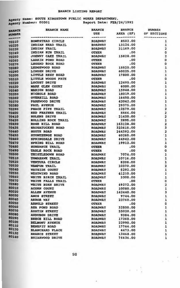
BRANCH LISTING REPORT
Ag•DCY Name: SOUTH KINGSTOWN PUBLIC WORKS DEPAR'l'MENT. Ag•DCY Number: 00001 Report Date: FEB/24/1992
------70210 70220 70230 70240 70250 70260 70270 70280 70290 70300 70310 70320 70330 70340 70350 70360 70370 70380 70390 70400 70410 70420 70430 70435 70440 70450 70460 70470 70480 70490 70500 70510 70520 70530 70540 70550 70560 70570 70580 80010 80020 80030 80040 80050 80060 80070 80080 80090 80100 10110 10120 80130 8ouo
BRANCH NAME
BOMESrEAD CIRCLE INDIAN BEAD 'l'RAIL INDIAN 'l'RAIL INDIAN RUN TRAIL JOHNNY CAJCE 'l'RAIL LARJtIN POND ROAD LEGEND Roa ROAD LEDGEWOOD ROAD LINDEN DRIVE LIT'l'LE REST ROAD LITrLE WOODS PATH LOCUST DRIVE MARX GLEN COURT KAR.ION ROAD NICHOLS ROAD OVERBILL ROAD P~OOD DRIVE PAUL AVENUE PEACE PIPE TRAIL RED ~R TRAIL ROLENS DRIVE ROLLING ROCK TRAIL ROSI!: BILL ROAD SAUGATUCJt:ET ROAD SOUTH ROAD S~NEBENGE ROAD SPRINGDALE DRIVE SPRING BILL ROAD SUNDANCE TRAIL ~ ROCK ROAD THISTLEDOWN ROAD TOMAHAWK TRAIL VEHTUllA CIRCLE WAMPUM 'l'RAIL WAYSIDE COURX WES'l'WIND ROAD WHITE BIRCB TRAIL WHITE FALLS 'l'RAIL WHITE BORN DRIVE ACORN COURT ALLEN AVENUE AMOS STREET ARBOR WAY ARNOLD STREET ASA POND ROAD AUSTIN STREET AUDUBON DRIVE BEECB BILL ROAD BELMONT AVENUE BENEFIT ROAD BLANCHARD PLACE BRANCH STREET BRIARWOOD DRIVE
98
BRANCH USE
ROADWAY ROADWAY ROADWAY O'l'HER ROADWAY O'l'HER OTHER ROADWAY ROADWAY ROADWAY
ROADWAY ROADWAY ROADWAY ROADWAY ROADWAY ROADWAY ROADWAY ROADWAY ROADWAY ROADWAY ROADWAY ROADWAY ROADWAY ROADWAY ROADWAY ROADWAY ROADWAY OTHER OTBER ROADWAY ROADWAY ROADWAY ROADWAY ROADWAY ROADWAY ROADWAY OTHER ROADWAY ROADWAY ROADWAY ROADWAY ROADWAY O'l'HER ROADWAY ROADWAY ROADWAY ROADWAY ROADWAY ROADWAY ROADWAY ROADWAY ROADWAY
BRAH CB AREA (SF)
8502.00 13124.00 31169 .oo
.oo 15828.00
.oo
.oo 15525.00 60025.00 17800.00
.oo 12495 .oo 6000.00
15948.00 15019 .oo 16450.00 42042.00 29375.00 12579.00
5566 .oo 21420.00 2895.00
163128.00 323615.00 244392.00
40260.00 44942.00 19912.00
.oo
.oo 7074.00
10716.00 8208.00
10370.00 5292.00
41210.00 3300.00
.oo 49272.00 10080.00
142440.00 9744 .oo
23760.00 .oo
32500.00 33020.00
9384.00 17360.00 22990 .oo 17766 .oo
4473.00 13468 . 00 76636.00
NUMBER OF SECTIONS
1 1 2 0 2 0 0 1 1 1 0 1 1 1 1 1 1 1 2 2 2 1 2 3 2 1 1 1 0 0 1 1 1 2 1 1 1 0 2 1 3 1 1 0 1 1 1 1 1 1 1 1 1

BRANCH LISTING REPORT
A9•DCY Naae: SOUTH KINGSTOWN PUBLIC wo~s DEPARTMENT. A9•DCY Nwab•rz 00001 Report Date: P'EB/24/1992
BRAJfCH NtJMBER ------80150 80160 80170 80180 80190 80200 80210 80220 80230 80240 80250 80260 80270 80280 80290 80300 80310 80315 80320 80330 80340 80350 80360 80370 80380 80390 80400 80410 80420 80430 80440 80450 80460 80470 80480 80490 80500 80510 80520 80530 80540 80545 80550 80560 80570 80580 80585 80590 80600 8ouo 80620 80630 aouo
BRANCH NAME
BROADMOOR ROAD BROAD ROCK ROAD BROOKWOOD ROAD BROWN STREET BOXWOOD DRIVE CARDINAL LANE CASWELL STREET CENTRAL AVENUE CHARLES STREET CHAPPELL STREET CHRISTOPHER STREET CHERRY LANE CBUJtCB STREET CLEVELAHD STREET COLUMBIA STREET CONGDON DRIVE DALE CARLIA STREET DAN STREET DENDRON ROAD DEWBERRY ROAD DOCKRAY S1'R.EET DOBSON ROAD DONNA co~ DIXON STREET EAGLE NEST TERRACE EDGEWATER ROAD ELDRED co~ ELDERBERRY LANE ELK STREET EISENHOWER PLACE FAGAN co~ FOSTER SHELDON ROAD GENTIAN DRIVE GEORGE STREET GEORGE SCHAEFFER STREET GOULD STREET GREEN STREET GREGORY STREET GREY BIRCH COURT HARRISON AVENUE HAZARD AVENUE HAZARD STREET HENDRICK STREET HIGBLAHD AVENUE HIGBVIEW AVENUE HILLCREST AVENUE HOLLEY STREET HOPE COURT BUNT AVENUE ICEBOUSE ROAD INDIAN RUN ROAD INKBERRY ROAD JOHNSON PLACE
99
BRANCH USE
ROADWAY ROADWAY ROADWAY ROADWAY ROADWAY ROADWAY ROADWAY ROADWAY ROADWAY ROADWAY ROADWAY ROADWAY ROADWAY ROADWAY ROADWAY ROADWAY ROADWAY ROADWAY ROADWAY ROADWAY ROADWAY ROADWAY ROADWAY ROADWAY ROADWAY ROADWAY ROADWAY ROADWAY ROADWAY ROADWAY ROADWAY ROADWAY ROADWAY ROADWAY ROADWAY ROADWAY ROADWAY ROADWAY ROADWAY ROADWAY ROADWAY ROADWAY ROADWAY ROADWAY ROADWAY ROADWAY ROADWAY ROADWAY ROADWAY ROADWAY ROADWAY ROADWAY ROADWAY
BRANCH AREA (SF)
9300.00 141714.00 37638.00 11826.00 6860.00
17640.00 8480.00
10890.00 14612 .oo 3708.00
30100.00 13662.00 83102.00 32320.00 99400 .oo 52494 .oo
8512.00 18512.00 51974.00 6160.00
42640.00 10076 .oo
5616.00 8942.00 9175.00
21620.00 9008.00
24080.00 10185.00 22965 .oo
6675 .oo 30800.00 33124.00
6300.00 29832.00 19416.00 13794.00 10332.00
9234.00 7500.00
11070.00 10824.00 9350.00
49032.00 6050.00
23960.00 46560.00
4890.00 47050.00
9600.00 7486.00
15120.00 15210.00
NUMBER OF SECTIONS
1 2 1 1 1 1 1 1 1 1 1 1 4 3 1 1 1 1 2 1 1 1 1 1 1 1 1 1 1 2 1 1 1 1 1 1 1 2 1 1 1 1 1 1 1 2 1 1 2 1 1 1 1

BRANCB LISTING REPO~
a9eDCJ Name: SOUTB KINGSTOWN PUBLIC WORKS DEPARTMENT.
Agency Nuab•rz 00001 Report Date: P'EB/24/1992
paHCB BRANCB NAME BRAN CB BRAN CB NUMBER
J11JMBER USE AR!:A (SP') OF SECTIONS
------ ------------------------- ------- --------- -----------80650 BOPJ'.:INS LANE ROADWAY 4667.00 1 80660 D!HYON AVENUE ROADWAY 91338.00 1 80670 Ja:NWOOD AVENUE ROADWAY 21125 .oo 1 80680 ltIMBALL STREET ROADWAY 4928.00 1 80690 ltINGSWOOD COURT ROADWAY 11200.00 1 80695 LADS~ ROADWAY 25848.00 1 80700 LAJlltIN STREET ROADWAY 6175.00 1 80710 LIBERTY STREET ROADWAY 9766.00 1 80720 NACARTBOR BOULEVARD ROADWAY 44620.00 1 80730 MEADOW AVENUE ROADWAY 31510.00 3 80740 MECHANIC STREET ROADWAY 12150.00 1 80750 ICELBllIDGE DRIVE ROADWAY 13225.00 1 80760 MIDDLE BnEET O'rBER .oo 0 80770 111JLBERJlY DRIVE ROADWAY 56000.00 1 80780 JIARRAGANSE'r.r AVENUE ROADWAY 36450.00 1 80790 HORllANDY ROAD ROADWAY 24380.00 1 80800 HORD ROAD ROADWAY 117912 .oo 3 80810 RO~ STREET ROADWAY 11454.00 1 80820 HYE SnEET ROADWAY 6780 .oo 1 80830 OAlt SnEET ROADWAY 36126.00 1 80840 OAlt DELL STREET ROADWAY 34523.00 2 80850 OAlt BILL ROAD ROADWAY 22100.00 1 80860 OAJtWOODS DRIVE ROADWAY 102419.00 1 80870 OLD llOtnr.rAIN ROAD ROADWAY 31680.00 l 80875 OLD POST ROAD ROADWAY 46920.00 1 80880 ORCHARD AVENUE ROADWAY 35075.00 1 80890 PADDY BILL ROAD ROADWAY 5180.00 1 80900 PERRY AVENUE OTHER .oo 0 80910 PERSHING AVENUE ROADWAY 29650.00 2 80920 PINE STREET ROADWAY 11340.00 1 80930 PINE BILL ROAD ROADWAY 95698.00 2 80940 PID STREET ROADWAY 10794.00 1 80950 PLEASANT STREET ROADWAY 14612 .oo 3 80960 POND SnEET ROADWAY 139125.00 l 80970 PROSPECT AVENUE ROADWAY 16680.00 2 80975 QOAGHUT DRIVE ROADWAY 28000.00 1 80980 RAILROAD STREET ROADWAY 25576.00 2 80990 RIVER STREET ROADWAY 36024.00 3 81000 RODMAN STREET ROADWAY 94300.00 1 11010 ROBINSON STREET ROADWAY 36532.00 2 11020 ROCltLAHD DRIVE ROADWAY 17820.00 1 11030 ROSE CIRCLE ROADWAY 3335.00 1 81040 SALT POND ROAD ROADWAY 96195 .oo 1 11050 BAKtJEL RODMAN STREET ROADWAY 14202.00 1 11060 SCHAEFFER STREET ROADWAY 17625 .oo 1 81070 SCHOOL LANE ROADWAY 4400.00 1 81080 SCHOOL STREET ROADWAY 41050.00 l 11090 SECLUDED DRIVE ROADWAY 19500.00 1 11100 SILVER LAD AVENUE ROADWAY 3993.00 2 81110 STEDMAN COURT ROADWAY 9492.00 l 81120 SNITH STREET ROADWAY 9310.00 l 11130 SPENCER COURT OTB!:R .oo 0 81140 STOHEWAY ROAD ROADWAY 53160.00 1
100

BRANCH LISTING REPORT
Agency Name1 SOUTH ~INOSTOWN PUBLIC WORJtS DEPARTMEN'.r. Agency Number: 00001 Report Date: P'EB/24/1992
8JlANCB NtJMBER ------81150 81160 81170 81190 81200 81210 81220 81230 81240 81250 81260 81265 81270 11280 81290 11300 81310 81320 81325 81330 81340 81350 81360 81370 81380 81390
BRANCH NAME
SWEET ALLEN FARM ROAD SWEET FERN LANE SUNSET AVENUE SPRUCE COURT STEVEN CIRCLE SPRING STREET ~N ROAD TOWN P'ARH ROAD TUCDR ROAD TOCDRTOWN ROAD OHCLE SAM LANE UPPEJl DRRACE CIRCLE VI~RY Snn:T WAIUfEJl AVENUE ~VANE ROAD WHITFORD STREET WILLARD AVENUE WILSON STREET WINCHESTER DRIVE WINDSOR ROAD WINTER STREET WOOD LANE WOODBINE ROAD WOODMAN'S TRAIL WOODRtJFP' AVENUE WRIGHT AVENUE
101
BRANCH USE
ROADWAY ROADWAY ROADWAY ROADWAY ROADWAY ROADWAY ROADWAY ROADWAY ROADWAY ROADWAY OTHER ROADWAY ROADWAY ROADWAY ROADWAY ROADWAY ROADWAY ROADWAY ROADWAY ROADWAY ROADWAY OTHER ROADWAY ROADWAY ROADWAY ROADWAY
roTALS
BRANCH AREA (SF)
100352.00 34800.00 14256.00 10894.00
4340.00 26500.00
9200.00 21087.00 10879.00
218880.00 .oo
9720.00 18425.00 15813.00
109200.00 39442.00 96945.00
4590.00 91200.00 7848.00
43850.00 .oo
46125.00 21636.00
103950.00 20000.00
13570793.00
NUMBER OF SECTIONS
1 1 1 1 1 1 1 1 1 1 0 1 1 1 1 1 1 1 1 1 1 0 1 1 2 1
413

APPENDIX C. PCI REPORTS
102

PCI REPORT
Agency Name: SOUTH KINGSTOWN PUBLIC WORKS DEPARTMENT. Agency Number: 00001 Report Date: APR/21/1991
Branch Number : All section Number: All Branch Use: All surface Type: All ?avement Rank: All zone: All section Category: All section Area: All Last construction Date: All Last Inspection Date: All PCI: All
BRANCH NUMBER/USE/
NAME
10010 / ROADWAY BARBER'S POND ROAD
10010 / ROADWAY BARBER'S POND ROAD
10010 / ROADWAY BARBER'S POND ROAD
10010 / ROADWAY BARBER'S POND ROAD
10010 / ROADWAY BARBER'S POND ROAD
10015 I ROADWAY BLACKBIRD ROAD
10020 / ROADWAY DUG-WAY-BRIDGE ROAD
10020 / ROADWAY DUG-WAY-BRIDGE ROAD
SECTION LAST LAST CONSTRUCT INSPECTION PCI
NUM/RANlt/SORF/AREA(SF) DATE DATE
001/ s I AC I 1062.00 AUG/01/1982 AUG/09/1988 100 CAT: A ZONE: WJCNG AGE (YRS): 6.0
002/ s I ST I 21936.00 AUG/01/1988 AUG/09/1988 44 CAT: A ZONE: WKNG AGE (YRS) : • 0
003/ s I ST I 1400.00 AUG/01/1982 AUG/09/1988 71 CAT: A ZONE: WJCNG AGE (YRS): 6.0
004/ S / AC / 3416.00 AUG/01/1982 AUG/09/1988 100 CAT: A ZONE: WICNG AGE (YRS): 6.0
005/ S / ST / 6916.00 AUG/01/1982 AUG/09/1988 71 CAT: A ZONE: WJCNG AGE (YRS): 6.0
001/ T I ST I 22968.00 AUG/01/1984 JUL/29/1988 89 CAT: A ZONE: WJCNG AGE (YRS): 4.0
001/ s I ST I 36000.00 AUG/01/1981 AUG/01/1989 100 CAT: A ZONE: WJCNG AGE (YRS): 8.0
002/ S / ST / 4400.00 AUG/01/1981 AUG/01/1989 100 CAT: A ZONE: WKNG AGE (YRS): 8.0
------------------------------------------------------------------------------10020 / ROADWAY DUG-WAY-BRIDGE ROAD
003/ S / ST / 88452.00 AUG/01/1981 AUG/01/1989 100 CAT: A ZONE: WJCNG AGE (YRS): 8.0
------------------------------------------------------------------------------10020 / ROADWAY DUG-WAY-BRIDGE ROAD
004/ S / X / 688.00 AUG/01/1981 AUG/01/1989 100 CAT: A ZONE: WKNG AGE (YRS): 8.0
------------------------------------------------------------------------------10030 / ROADWAY ESTELLE DRIVE
001/ T / ST / 57225.00 AUG/01/1983 AUG/02/1988 71 CAT: A ZONE: WKNG AGE (YRS): 5.0
------------------------------------------------------------------------------10040 / ROADWAY FAIRGROUNDS ROAD
001/ s I ST I 60000.00 AUG/01/1988 OCT/21/1988 84 CAT: A ZONE: WKNG AGE (YRS): .2
------------------------------------------------------------------------------10040 I ROADWAY FAIRGROUNDS ROAD
002/ S / ST / 48465.00 AUG/01/1988 OCT/21/1988 90 CAT: A ZONE: WKNG AGE (YRS): .2
------------------------------------------------------------------------------
103

PCI REPORT
Aqency Name: SOOTH KINGSTOWN PUBLIC WORKS DEPARTMENT.
BRANCH NUMBER/USE/
NAME
SECTION
NUM/RANK/SURF/AREA(SF)
LAST LAST CONSTRUCT INSPECTION PCI
DATE DATE
------------------------------------------------------------------------------10040 I ROADWAY FAIRGROUNDS ROAD
003/ s I ST I 83534 . 00 AUG/01/1983 NOV/08/1988 83 CAT: A ZONE: WKNG AGE (YRS) : 5 . 3
------------------------------------------------------------------------------10050 I ROADWAY GLEN ROCK ROAD
001/ T / ST / 32357.00 AUG/01/1981 AUG/01/1989 100 CAT: A ZONE: WKNG AGE (YRS): 8 . 0
------------------------------------------------------------------------------10050 / ROADWAY GLEN ROC!t ROAD
002/ T / ST / 94297.00 AUG/01/1981 AUG/01/1989 100 CAT: A ZONE: WJCNG AGE (YRS) : 8.0
------------------------------------------------------------------------------10050 / ROADWAY GLEN ROC!t ROAD
003/ T / ST / 30600.00 AUG/01/1981 AUG/01/1989 100 CAT: A ZONE: WJCNG AGE (YRS): 8.0
---~--~-------------~-------------------------------------------------10060 I ROADWAY 001/ s I ST I 39028.00 JAN/01/1988 AUG/02/1988 75 HUNDRED ACRE POND ROAD CAT: A ZONE: WJCNG AGE (YRS): .6
-----------------------------------------------------------------10080 / ROADWAY JAMES TRAIL
001/ T I ST I 29408.00 JAN/01/1960 AUG/01/1989 100 CAT: A ZONE: WXNG AGE (YRS) : 2 9. 6
----------------------------------------------------------------------------10100 / ROADWAY LAUREL LANE
10110 / ROADWAY LIBERTY LANE
10115 / ROADWAY OLD OSQUEPAOGB ROAD
10120 / ROADWAY QUEEN'S RIVER DRIVE
10130 / ROADWAY SAND TURN ROAD
10140 / ROADWAY WAITES CORNER ROAD
10140 I ROADWAY WAITES CORNER ROAD
10140 / ROADWAY WAITES CORNER ROAD
001/ T / ST / 57380.00 AUG/01/1984 . AUG/04/1988 75 CAT: A ZONE: WJCNG AGE (YRS): 4.0
001/ S / ST / 133749.00 AUG/01/1988 NOV/09/1988 87 CAT: A ZONE: WJCNG AGE (YRS): .3
001/ T I AC I 13440.00 JUN/01/1989 JUN/16/1989 100 CAT: A ZONE: WJtNG AGE (YRS): .O
001/ T I ST I 34086.00 JAN/01/1960 AOG/03/1988 82 CAT: A ZONE: WJtNG AGE (YRS): 28.6
001/ T / ST / 120865.00 AOG/01/1984 AUG/05/1988 66 CAT: A ZONE: WKNG AGE (YRS) : 4.0
001/ S / ST / 29175.00 AUG/01/1985 AUG/11/1988 76 CAT: A ZONE: WKNG AGE (YRS): 3.0
002/ S / AC / 2852.00 AUG/01/1985 AUG/11/1988 100 CAT: A ZONE: WJtNG AGE (YRS): 3.0
003/ S / ST / 86760.00 AUG/01/1985 AUG/11/1988 84 CAT: A ZONE: WKNG AGE (YRS): 3.0
------------------------------------------------------------------------------10140 / ROADWAY WAITES CORNER ROAD
004/ S / AC / 984.00 AUG/01/1985 AUG/11/1988 100 CAT: A ZONE: WJtNG AGE (YRS): 3 . 0
------------------------------------------------------------------------------10140 / ROADWAY WAITES CORNER ROAD
005/ S / AC / 1200.00 AUG/01/1985 AUG/11/1988 100 CAT: A ZONE: WKNG AGE (YRS): 3.0
------------------------------------------------------------------------------10140 / ROADWAY WAITES CORNER ROAD
006/ S / ST / 52954.00 AUG/01/1985 AUG/ll/1988 66 CAT: A ZONE: WKNG AGE (YRS) : 3.0
------------------------------------------------------------------------------10150 / ROADWAY YAWGOO POND ROAD
001/ T / ST / 59058.00 AUG/01/1984 AUG/05/1988 86 CAT: A ZONE: WKNG AGE (YRS): 4.0
104

PCI REPORT
Agency Name: SOUTH KINGSTOWN PUBLIC WORKS DEPARTMENT.
BRANCH NUMBER/USE/
NAME
SECTION
NUM/RANK/SURF/AREA(SF)
LAST LAST CONSTRUCT INSPECTION PCI
DATE DATE
------------------------------------------------------------------------------------------------------------------------------------------------------------20010 I ROADWAY ALTIN ROAD
001/ T I ST I 8212.00 AUG/01/1980 SEP/14/1988 0 CAT: B ZONE: URI AGE (YRS): 8.1
------------------------------------------------------------------------------20020 / ROADWAY BAYBERRY ROAD
001/ s I ST I 19700.00 AUG/01/1986 JUL/18/1989 96 CAT: A ZONE: URI AGE (YRS): 3 . 0
------------------------------------------------------------------------------20050 / ROADWAY BERTH AVENUE
001/ T I ST I 3600.00 AUG/01/1988 SEP/14/1988 33 CAT: B ZONE: URI AGE (YRS): .1
------------------------------------------------------------------------------20060 / ROADWAY BILLS ROAD
001/ T / ST / 34200.00 AUG/01/1983 JUN/01/1988 30 CAT: B ZONE: URI AGE (YRS): 4.8 -------·-----------------------------·------·--
20070 / ROADWAY BRIAR LANE
001/ T I ST I 30082.00 AUG/01/1986 JUN/10/1988 90 CAT: B ZONE: URI AGE (YRS): 1 . 9
------------------------------------------------------------------------------20090 / ROADWAY CAMPOS AVENUE
20100 / ROADWAY CARRIAGE LANE
20110 / ROADWAY CEDAR CIRCLE
20120 / ROADWAY CHAPEL WAY
20130 / ROADWAY DIANE DRIVE
20160 / ROADWAY FORTIN ROAD
20170 I ROADWAY FRANK AVENUE
20180 / ROADWAY FRENCH ROAD
20220 / ROADWAY OLD NORTH ROAD
OOl/ T / ST / 25732.00 AOG/01/1986 JUN/15/1988 80 CAT: B ZONE: URI AGE (YRS): 1.9
001/ T / AC / 12600.00 AUG/01/1988 AUG/01/1988 100 CAT: B ZONE: URI AGE (YRS): .O
001/ T / ST / 10070.00 AUG/01/1986 AUG/22/1988 94 CAT: A ZONE: URI AGE (YRS): 2.1
001/ T / ST / 27600.00 AOG/01/1982 JUN/08/1988 71 CAT: B ZONE: URI AGE (YRS): 5.9
001/ T / AC / 16380.00 AUG/01/1980 SEP/14/1988 24 CAT: B ZONE: URI AGE (YRS): 8.1
001/ T / ST / 36480.00 AUG/01/1986 JUN/08/1988 54 CAT: B ZONE: URI AGE (YRS): 1.9
001/ T / ST / 26262.00 AUG/01/1980 SEP/19/1988 11 CAT: B ZONE: URI AGE (YRS): 8.1
001/ T I ST I 9400.00 AUG/01/1981 JUL/18/1989 63 CAT: A ZONE: URI AGE (YRS): 8.0
001/ P / AC / 22296.00 AUG/01/1983 AUG/22/1988 100 CAT: A ZONE: URI AGE (YRS): 5.1
------------------------------------------------------------------------------20220 / ROADWAY OLD NORTH ROAD
002/ p I AC I 13896.00 AUG/01/1983 AUG/22/1988 78 CAT: A ZONE: URI AGE (YRS): 5.1
------------------------------------------------------------------------------20220 / ROADWAY OLD NORTH ROAD
003/ p I AC I 23232.00 AUG/01/1983 AUG/22/1988 100 CAT: A ZONE: URI AGE (YRS): 5.1
------------------------------------------------------------------------------20220 I ROADWAY OLD NORTH ROAD
004/ P / AC / 21696.00 AUG/01/1983 AUG/22/1988 100 CAT: A ZONE: URI AGE (YRS): 5.1
------------------------------------------------------------------------------20220 I ROADWAY 005/ P / ST / 99968.00 AUG/01/1983 AUG/22/1988 72
105
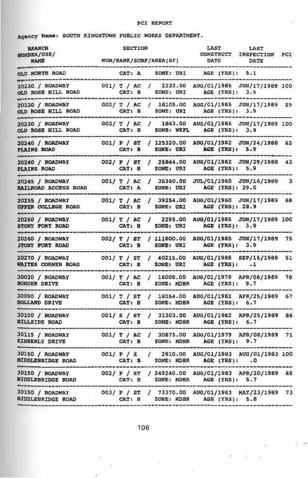
PCI REPORT
Agency Name: SOUTH KINGSTOWN PUBLIC WORKS DEPARTMENT.
BRANCH NUMBER/USE/
NAME
SECTION
NUM/RANK/SURF/AREA(SF)
LAST LAST CONSTRUCT INSPECTION PCI
DATE DATE
------------------------------------------------------------------------------OLD NORTH ROAD CAT: A ZONE: URI AGE (YRS) : 5 . l
------------------------------------------------------------------------------20230 I ROADWAY OLD ROSE HILL ROAD
001/ T / AC / 2232.00 AUG/01/1985 JUN/17/1989 100 CAT: B ZONE: URI AGE (YRS): 3.9
------------------------------------------------------------------------------20230 / ROADWAY OLD ROSE HILL ROAD
002/ T I AC I 18105.00 AUG/01/1985 JUN/17/1989 59 CAT: B ZONE: URI AGE (YRS): 3.9
------------------------------------------------------------------------------20230 I ROADWAY OLD ROSE HILL ROAD
003/ T I AC I 1843.00 AUG/01/1985 JUN/17/1989 100 CAT: B ZONE: WKFL AGE (YRS) : 3. 9
--------------------------------------------------·----------------20240 I ROADWAY PLAINS ROAD
001/ p I ST I 125320.00 AUG/01/1982 JUN/24/1988 62 CAT: B ZONE: URI AGE (YRS): 5.9
---------------------------------------------------------------------20240 / ROADWAY PLAINS ROAD
20245 / ROADWAY RAILROAD ACCESS ROAD
20255 / ROADWAY OPPER COLLEGE ROAD
20260 / ROADWAY STONY FORT ROAD
20260 / ROADWAY .lTONY PORT ROAD
20270 / ROADWAY WAITES CORNER ROAD
30030 / ROADWAY BORDER DRIVE
30090 I ROADWAY HOLLAND DRIVE
30100 / ROADWAY HILLSIDE ROAD
30115 / ROADWAY JtIMBERLY DRIVE
30150 / ROADWAY MIDDLEBRIDGE ROAD
002/ p I ST I 25844.00 AUG/01/1982 JUN/29/1988 43 CAT: B ZONE: ORI AGE (YRS): 5.9
001/ T I AC I 36360.00 JUL/01/1960 JUN/16/1989 3 CAT: A ZONE: URI AGE (Y~): 29.0
001/ T / AC . / 39254.00 AUG/01/1960 JUN/17/1989 68 CAT: B ZONE: URI AGE (YRS): 28.9
001/ T I AC I 2295.00 AUG/01/1985 JUN/17/1989 100 CAT: B ZONE: ORI AGE (YRS): 3.9
002/ T / ST / 111800.00 AUG/01/1985 JUN/17/1989 75 CAT: B ZONE: URI AGE (YRS): 3.9
001/ T / ST / 40215.00 AUG/01/1988 SEP/15/1988 51 CAT: B ZONE: URI AGE (YRS): .1
001/ T / AC / 16008.00 AUG/01/1979 APR/08/1989 78 CAT: B ZONE: MDBR AGE (YRS): 9.7
001/ T / ST / 18054.00 AUG/01/1982 APR/25/1989 67 CAT: B ZONE: MDBR AGE (YRS): 6.7
001/ S / ST / 31303.00 AUG/01/1982 APR/25/1989 86 CAT: B ZONE: MDBR AGE (YRS): 6.7
001/ T / AC / 30875.00 AUG/01/1979 APR/08/1989 71 CAT: B ZONE: MDBR AGE (YRS): 9.7
001/ p I x I 2910.00 AUG/01/1983 AUG/01/1983 100 CAT: B ZONE: MDBR AGE (YRS): .O
------------------------------------------------------------------------------30150 / ROADWAY MIDDLEBRIDGE ROAD
002/ P / ST / 249240.00 AUG/01/1983 APR/20/1989 65 CAT: B ZONE: MDBR AGE (YRS): 5.7
------------------------------------------------------------------------------30150 / ROADWAY MIDDLEBRIDGE ROAD
003/ P / ST / 73370.00 AUG/01/1983 MAY/23/1989 73 CAT: B ZONE: MDBR AGE (YRS): 5.8
------------------------------------------------------------------------------
106

PCI REPORT
Agency Name: SOUTH KINGSTOWN PUBLIC WORKS DEPARTMENT.
BRANCH NtJKBER/USE/
NAME
SECTION
NUM/RANK/SURF/AREA(SF)
LAST CONSTRUCT
DATE
LAST INSPECTION PCI
DATE
------------------------------------------------------------------------------30170 I ROADWAY NARRAGANSETT AVENUE
001/ T / AC / 29735.00 AUG/01/1982 APR/13/1989 35 CAT: B ZONE: MDBR AGE (YRS): 6.7
------------------------------------------------------------------------------30190 / ROADWAY PECKHAM AVENUE
30200 / ROADWAY PINE COURT
30220 / ROADWAY RADIAL DRIVE
30240 / ROADWAY RIVERSIDE DRIVE
30250 / ROADWAY SEAVIEW AVENUE
30250 I ROADWAY SEAVIEW AVENUE
30260 / ROADWAY SHADBUSH TRAIL
30270 I ROADWAY SUMMIT AVENUE
30280 / ROADWAY TORREY ROAD
30300 / ROADWAY WALMSLEY LANE
40020 / ROADWAY ATLANTIC AVENUE
40030 I ROADWAY ATLANTIC STREET
001/ T I AC I 17250.00 AUG/01/1974 APR/08/1989 83 CAT: B ZONE: MDBR AGE (YRS): 14.7
001/ T / AC / 1596.00 AUG/01/1965 APR/01/1989 41 CAT: B ZONE: MDBR AGE (YRS): 23.7
001/ T I ST I 4715.00 AOG/01/1983 MAR/31/1989 79 CAT: B ZONE: MDBR AGE (YRS): 5.7
001/ T / ST / 48346.00 AOG/01/1983 APR/01/1989 75 CAT: B ZONE: MDBR AGE (YRS): 5.7
001/ T I ST I 17424.00 AOG/01/1982 APR/08/1989 36 CAT: B ZONE: MDBR AGE (YRS): 6.7
002/ T I ST I 3640.00 AUG/01/1982 APR/08/1989 100 CAT: B ZONE: MDBR AGE (YRS): 6.7
001/ T ST / 5424.00 AUG/01/1983 MAR/31/1989 81 CAT: B ZONE: MDBR AGE (YRS): 5.7
001/ T / ST / 13040.00 AOG/01/1982 APR/08/1989 . 86 CAT: B ZONE: MDBR AGE (YRS): 6. 7
001/ p I AC I 72150.00 AUG/01/1987 APR/13/1989 83 CAT: B ZONE: MDBR AGE (YRS): 1.7
001/ T / AC / 3900.00 AUG/01/1965 APR/13/1989 39 CAT: B ZONE: MDBR AGE (YRS): 23.7
001/ T / ST / 40530.00 AUG/01/1985 DEC/15/1988 52 CAT: A ZONE: MTNK AGE (YRS): 3.4
001/ T / ST / 16236.00 AUG/01/1983 MAY/22/1989 86 CAT: A ZONE: MTNK AGE (YRS): 5.8
------------------------------------------------------------------------------40050 / ROADWAY BASS ROAD
001/ T / ST / 16350.00 AUG/01/1984 DEC/27/1988 57 CAT: A ZONE: MTNJ< AGE (YRS): 4.4
------------------------------------------------------------------------------40050 I ROADWAY BASS ROAD
002/ T / ST / 6816.00 AUG/01/1984 DEC/27/1988 100 CAT: A ZONE: MTNK AGE (YRS): 4.4
------------------------------------------------------------------------------40060 / ROADWAY BLACKBERRY HILL DRIVE
001/ S / ST / 39817.00 AUG/01/1984 DEC/12/1988 72 CAT: A ZONE: MTNK AGE (YRS): 4.4
------------------------------------------------------------------------------40060 / ROADWAY BLACKBERRY HILL DRIVE
002/ S / ST / 21196.00 AUG/01/1984 DEC/22/1988 70 CAT: A ZONE: MTNK AGE (YRS): 4.4
------------------------------------------------------------------------------40060 I ROADWAY BLACKBERRY HILL DRIVE
003/ S / AC / 32567.00 AUG/01/1987 DEC/22/1988 100 CAT: A ZONE: MTNK AGE (YRS): 1.4
107

PCI REPORT
Agency Name: SOUTH KINGSTOWN PUBLIC WORKS DEPARTMENT .
BRANCH NUMBER/USE/
NAME
SECTION
NUM/RANK/SURF/AREA(SF)
LAST LAST CONSTRUCT INSPECTION PCI
DATE DATE
------------------------------------------------------------------------------------------------------------------------------------------------------------40070 I ROADWAY BLISS ROAD
001/ T / ST / 24273.00 AUG/01/1983 MAY/22/1989 69 CAT: A ZONE: MTNK AGE (YRS) : 5 . 8
------------------------------------------------------------------------------40090 I ROADWAY BREAKWATER ROAD
001/ S / ST / 25350.00 AUG/01/1984 DEC/22/1988 48 CAT: A ZONE: MTNK AGE (YRS): 4 . 4
------------------------------------------------------------------------------40090 I ROADWAY BREAKWATER ROAD
002/ S / ST / 12320.00 AUG/Ol/1984 DEC/22/1988 77 CAT: A ZONE: MTNK AGE (YRS): 4.4
------------------------------------------------------------------------------40100 / ROADWAY CARDS POND ROAD
001/ S / ST / 139702.00 AOG/01/1982 DEC/27/1988 33 CAT: A ZONE: KTNK AGE (YRS): 6.4
-------------------------------------------------------------40110 / ROADWAY CENTRAL STREET
001/ T / ST / 9216.00 AOG/01/1985 DEC/15/1988 17 CAT: A ZONE: KTNK AGE (YRS): 3.4
------------------------------------------------------------------------------40150 / ROADWAY COVE STREET
40170 / ROADWAY DORY COURT
40190 / ROADWAY GALE DRIVE
001/ T / ST / 7326.00 AOG/01/1985 DEC/15/1988 88 CAT: A ZONE: KTNK AGE (YRS): 3.4
001/ T / AC / 8802.00 AOG/01/1965 MAY/23/1989 63 CAT: A ZONE: KTNK AGE (YRS): 23.8
001/ T I AC I 32184.00 AOG/01/1965 MAY/23/1989 93 CAT: A ZONE: KTNK AGE (YRS): 23.8
------------------------------------------------------------------------------40200 / ROADWAY GOOSEBERRY ROAD
40210 / ROADWAY HARTFORD A VENUE
40220 / ROADWAY HEATHER HOLLOW DRIVE
40230 I ROADWAY BILL ROAD
40240 / ROADWAY BOLDEN ROAD
40250 / ROADWAY BOWARD CIRCLE
001/ P / ST / 113750.00 AOG/01/1983 MAY/22/1989 Sl CAT: A ZONE: KTNK AGE (YRS): 5.8
001/ T / ST / 24800.00 AUG/01/1983 MAY/22/1989 44 CAT: A ZONE: MTNK AGE (YRS): 5.8
001/ T I ST I 31044.00 AUG/01/1983 JUN/10/1989 61 CAT: A ZONE: MTNK AGE (YRS): 5.9
001/ T / ST / 8109.00 AUG/01/1965 MAY/22/1989 l CAT: A ZONE: MTNK AGE (YRS): 23.8
001/ T / ST / 20420.00 AUG/01/1983 DEC/15/1988 74 CAT: A ZONE: MTNK AGE (YRS): 5.4
001/ T / AC / 7722.00 AOG/01/1980 DEC/15/1988 98 CAT: A ZONE: MTNK AGE (YRS): 8.4
------------------------------------------------------------------------------40260 / ROADWAY BOLL STREET
001/ T / ST / 19656.00 AOG/Ol/1983 MAY/22/1989 65 CAT: A ZONE: MTNK AGE (YRS): 5.8
------------------------------------------------------------------------------40280 / ROADWAY UltE AVENUE
001/ T / ST / 40000 . 00 AUG/01/1985 DEC/05/1988 69 CAT: A ZONE: MTNK AGE (YRS): 3.3
------------------------------------------------------------------------------40300 I ROADWAY LoWER FARM ROAD
001/ s I ST I 15813.00 AUG/01/1984 DEC/15/1988 50 CAT: A ZONE: MTNK AGE (YRS): 4.4
------------------------------------------------------------------------------40320 I ROADWAY 001/ p I AC I 137900.00 AUG/01/1984 JUN/06/1989 66
108

PCI REPORT
Agency Name: SOUTH KINGSTOWN PUBLIC WORKS DEPARTMENT.
BRANCH NUMBER/USE/
NAME
SECTION
NUM/RANK/SURF/AREA(SF)
LAST LAST CONSTRUCT INSPECTION PCI
DATE DATE
------------------------------------------------------------------------------KATUNUCK BEACH ROAD CAT: A ZONE: MTNK AGE (YRS ) : 4 . 8
------------------------------------------------------------------------------40320 I ROADWAY KATUNUCK BEACH ROAD
40320 I ROADWAY KATUNUCK BEACH ROAD
002/ p I AC I 53433.00 AUG/01/1984 JUN/20/1989 11 CAT: A ZONE: MTNK AGE (YRS): 4.9
003/ P / AC / 68970.00 AUG/01/1984 JUN/20/1989 83 CAT: A ZONE: MTNK AGE (YRS): 4.9
40325 / ROADWAY 001/ S / ST / 123486.00 AUG/01/1982 AUG/01/1989 100 KATUNUCK SCHOOL HOUSE RD. CAT: A ZONE: MTNK AGE (YRS): 7.0
40330 / ROADWAY MEADOW STREET
40360 / ROADWAY MOONSTONE BEACH ROAD
40360 / ROADWAY MOONSTONE BEACH ROAD
40380 / ROADWAY NORTH WEEDEN ROAD
40390 / ROADWAY OCEAN AVENUE
40400 / ROADWAY OLD SUCCOTASH ROAD
40400 I ROADWAY OLD SUCCOTASH ROAD
40410 I ROADWAY OLIVER DRIVE
001/ T / ST / 15113.00 AOG/01/1983 MAY/22/1989 79 CAT: A ZONE: KTNJC AGE (YRS): 5.8
001/ s I ST I 128976.00 AOG/01/1982 JUN/19/1989 39 CAT: A ZONE: MT?a AGE (YRS): 6.9
002/ s I ST I 38980.00 AOG/01/1982 JUN/20/1989 58 CAT: A ZONE: MTNK AGE (YRS): 6.9
001/ T / ST / 17871.00 AOG/01/1984 DEC/22/1988 68 CAT: A ZONE: KTNJC AGE (YRS): 4.4
001/ T I AC I 23446.00 AOG/01/1965 JUN/08/1989 66 CAT: A ZONE: KTNJC AGE (YRS): 23.9
001/ T / ST / 17138.00 AUG/01/1982 FEB/01/1989 59 CAT: A ZONE: MTNK AGE (YRS): 6.5
002/ T / ST / 36300.00 AUG/01/1982 FEB/01/1989 60 CAT: A ZONE: MTNK AGE (YRS): 6.5
001/ T / ST / 6972.00 AUG/01/1985 DEC/27/1988 62 CAT: A ZONE: KTNK AGE (YRS): 3.4
------------------------------------------------------------------------------40420 / ROADWAY OSPREY ROAD
40430 / ROADWAY PARK AVENUE
40460 I ROADWAY PERRYWINKLE ROAD
001/ s / AC / 86800.00 OCT/01/1979 DEC/15/1988 76 CAT: A ZONE: KTNK AGE (YRS): 9.2
001/ S / ST / 30996.00 AUG/01/1985 DEC/08/1988 77 CAT: A ZONE : MTNK AGE (YRS): 3.4
001/ T / ST / 10605.00 AUG/01/1983 MAY/22/1989 83 CAT: A ZONE: MTNK AGE (YRS): 5.8
------------------------------------------------------------------------------40500 / ROADWAY PROSPECT ROAD
001/ T I ST I 47744.00 AUG/01/1983 JUN/10/1989 56 CAT: A ZONE: KTNK AGE (YRS): 5.9
------------------------------------------------------------------------------40510 I ROADWAY SEABREEZE TERRACE
001/ T / ST / 22950.00 AUG/01/1985 DEC/27/1988 58 CAT: A ZONE: KTNK AGE (YRS): 3.4
------------------------------------------------------------------------------40550 I ROADWAY SHELLDRAKE ROAD
001/ S / ST / 476672.00 AUG/01/1984 DEC/12/1988 53 CAT: A ZONE: KTNK AGE (YRS): 4.4
------------------------------------------------------------------------------
109
PCI REPORT
Aqency Name: SOUTH KINGSTOWN PUBLIC WORKS DEPARTMENT.
BRANCH NUMBER/USE/
NAME
SECTION
NUM/RANK/SURF/AREA(SF)
LAST LAST CONSTRUCT INSPECTION PCI
DATE DATE
------------------------------------------------------------------------------40560 I ROADWAY SHERMAN ROAD
001/ T / ST / 17367.00 AUG/01/1984 MAY/22/1989 77 CAT: A ZONE: MTNK AGE (YRS): 4.8
------------------------------------------------------------------------------40580 I ROADWAY SOOTH WEEDEN ROAD
40610 / ROADWAY SOMMER STREET
40630 / ROADWAY TIDAL STREET
40640 / ROADWAY WAGER LANE
40650 / ROADWAY WASHINGTON STREET
40650 / ROADWAY WASHINGTON STREET
40670 / ROADWAY WEST STREET
40680 / ROADWAY WEST SIDE ROAD
50010 / ROADWAY ASPEN ROAD
50020 / ROADWAY AUBURN ROAD
50020 / ROADWAY AUBURN ROAD
50030 / ROADWAY BALSAM ROAD
001/ T / ST / 51425.00 AUG/01/1984 DEC/22/1988 61 CAT: A ZONE: KTNK AGE (YRS) : 4 . 4
001/ T / ST / 16320.00 AUG/01/1965 MAY/22/1989 59 CAT: A ZONE: MTNK AGE (YRS): 23.8
001/ T I AC I 8775.00 AUG/01/1965 MAY/23/1989 82 CAT: A ZONE: MTNK AGE (YRS): 23.8
001/ s I AC I 5600.00 OCT/01/1979 DEC/15/1988 100 CAT: A ZONE: MTNK AGE (YRS): 9. 2
001/ T / ST / 26439.00 AUG/01/1985 NOV/23/1988 91 CAT: A ZONE: KTNK AGE (YRS) : 3 • 3
002/ T / ST / 17934.00 AUG/01/1985 NOV/23/1988 SS CAT: A ZONE: MTNK AGE (YRS): 3.3
001/ T / ST / 13091.00 AUG/01/1983 MAY/22/1989 58 CAT: A ZONE: MTNK AGE (YRS): S.S
001/ T / ST / 5886.00 AUG/01/1982 MAY/23/1989 32 CAT: A ZONE: MTNK AGE (YRS): 6.8
001/ T / ST / 25231.00 AUG/01/1965 MAY/13/1989 91 CAT: A ZONE: GRNH AGE (YRS): 23.8
001/ T / ST / 32760.00 AUG/01/1965 MAY/13/1989 81 CAT: A ZONE: GRNH AGE (YRS): 23.8
002/ T / ST / 10108.00 AUG/01/1965 MAY/13/1989 76 CAT: A ZONE: GRNH . AGE (YRS): 23.8
001/ T I ST I 62223.00 JUL/01/1974 MAY/23/1989 72 CAT: A ZONE: GRNH AGE (YRS): 14.9
------------------------------------------------------------------------------50050 / ROADWAY BEDFORD DRIVE
001/ T I ST I 36772.00 AUG/ll/1965 MAY/13/1989 76 CAT: A ZONE: GRNH AGE (YRS): 23.8
------------------------------------------------------------------------------50060 / ROADWAY BIRCH ROAD
001/ T I ST I 4086.00 AUG/01/1978 MAY/23/1989 57 CAT: A ZONE: GRNH AGE (YRS): 10.8
------------------------------------------------------------------------------50060 / ROADWAY BIRCH ROAD
002/ T I ST I 3705.00 AUG/01/1978 MAY/23/1989 56 CAT: A ZONE: GRNH AGE (YRS): 10.8
------------------------------------------------------------------------------50060 I ROADWAY BIRCH ROAD
003/ T / ST / 4683.00 AOG/01/1978 MAY/23/1989 10 CAT: A ZONE: GRNH AGE (YRS): 10.8
------------------------------------------------------------------------------50060 / ROADWAY BIRCH ROAD
004/ T / ST / 4122.00 AUG/01/1978 MAY/23/1989 9 CAT: A ZONE: GRNH AGE (YRS): 10.8
110

PCI REPORT
Aqency Name: SOUTH KINGSTOWN PUBLIC WORKS DEPARTMENT.
BRANCH NUMBER/USE/
NAME
SECTION
NUM/RANK/SURF/AREA(SF)
LAST LAST CONSTRUCT INSPECTION PCI
DATE DATE
------------------------------------------------------------------------------------------------------------------------------------------------------------S0060 I ROADWAY BIRCH ROAD
005/ T / ST / 3285.00 AUG/01/1978 MAY/23/1989 57 CAT: A ZONE: GRNH AGE (YRS): 10.8
------------------------------------------------------------------------------50080 I ROADWAY BROWNING STREET
001/ T / ST / 32256.00 AUG/01/1984 MAY/14/1989 46 CAT: A ZONE: GRNH AGE (YRS): 4. 8
------------------------------------------------------------------------------50090 / ROADWAY CANTERBURY ROAD
001/ T / ST / 46900.00 AUG/01/1965 MAY/13/1989 64 CAT: A ZONE: GRNH AGE (YRS): 23.8
-----------------------------------------------~----------------------------50100 / ROADWAY CARPENTER DRIVE
001/ T I ST I 81660.00 AOG/01/1984 MAY/14/1989 68 CAT: A ZONE: GRNH AGE (YRS): 4.8
-------------------------------------------------------50120 I ROADWAY COAST GUARD AVENUE
001/ T / ST / 7568.00 AOG/01/1984 MAY/14/1989 78 CAT: A ZONE: GRNH AGE (YRS): 4.8
------------------------------------------------------------------------------50130 / ROADWAY COREY ROAD
50140 / ROADWAY DARTMOUTH LANE
50160 I ROADWAY ELK ROAD
50160 / ROADWAY ELK ROAD
50170 / ROADWAY GREEN HILL AVENUE
001/ T / AC / 16800.00 AUG/01/1988 FEB/07/1989 100 CAT: A ZONE: GRNH AGE (YRS): .S
001/ T / ST / 6104.00 AUG/01/1965 MAY/13/1989 62 CAT: A ZONE: GRNH AGE (YRS): 23.8
001/ T / AC / 9080.00 SEP/01/1970 MAY/25/1989 40 CAT: A ZONE: GRNH AGE (YRS): 18.7
002/ T / AC / 5886.00 SEP/01/1970 MAY/25/1989 40 CAT: A ZONE: GRNH AGE (YRS): 18.7
001/ T I ST I 14292.00 OCT/01/1970 MAY/14/1989 60 CAT: A ZONE: GRNH AGE (YRS): 18.6
50180 / ROADWAY 001/ P / ST / 126720.00 AUG/01/1978 MAY/25/1989 58 GREEN HILL BEACH ROAD CAT: A ZONE: GRNH AGE (YRS): 10.8
50180 / ROADWAY 002/ P / ST / 100648.00 AUG/01/1978 MAY/25/1989 67 GREEN HILL BEACH ROAD CAT: A ZONE: GRNH AGE (YRS): 10.8
50190 / ROADWAY 8EKLOC1t ROAD
50200 / ROADWAY HILL TOP AVENUE
001/ T / ST / 52344.00 JUL/01/1974 MAY/25/1989 55 CAT: A ZONE: GRNH AGE (YRS): 14.9
001/ T / ST / 19550.00 AUG/01/1984 MAY/14/1989 66 CAT: A ZONE: GRNH AGE (YRS): 4.8
------------------------------------------------------------------------------50210 / ROADWAY HOLLY ROAD
001/ T I AC I 21160.00 JTJL/01/1971 MAY/23/1989 8 CAT: A ZONE: GRNH AGE (YRS): 17.9
------------------------------------------------------------------------------50210 / ROADWAY HOLLY ROAD
002/ T I AC I 8340.00 JUL/01/1971 MAY/23/1989 94 CAT: A ZONE: GRNH AGE (YRS): 17.9
------------------------------------------------------------------------------50210 / ROADWAY HOLLY ROAD
003/ T I AC I 66624.00 JUL/01/1971 MAY/23/1989 57 CAT: A ZONE: GRNH AGE (YRS): 17.9
------------------------------------------------------------------------------50220 / ROADWAY 001/ T / ST / 58652.00 AUG/01/1974 MAY/23/1989 64
111

PCI llEPORT
Agency Name: SOUTH KINGSTOWN PUBLIC WORKS DEPARTMENT.
BRANCH NUMBER/USE/
NAME
SECTION
NUM/RANK/SURF/AllEA(SF)
LAST LAST CONSTRUCT INSPECTION PCI
DATE DATE
------------------------------------------------------------------------------JUNIPER ROAD CAT: A ZONE: GRNH AGE (YRS): 14.8
------------------------------------------------------------------------------50240 I ROADWAY LAUllEL ROAD
001/ T / ST / 3450.00 OCT/01/1970 MAY/23/1989 39 CAT: A ZONE: GRNH AGE (YRS): 18.6
------------------------------------------------------------------------------50240 I ROADWAY LAUllEL ROAD
50240 I ROADWAY LAUllEL ROAD
002/ T I AC I 4880.00 OCT/01/1970 MAY/23/1989 42 CAT: A ZONE: GRNH AGE (YRS): 18.6
003/ T / AC / 3568.00 OCT/01/1970 MAY/23/1989 36 CAT: A ZONE: GRNH AGE (YRS): 18.6
50250 / ROADWAY 001/ P / ST / 94600.00 AUG/01/1982 AUG/01/1989 100 KATUNUClt SCHOOL BOUSE RD. CAT: A ZONE: GRNH AGE (YRS): 7 .O
50250 / ROADWAY 002/ P / ST / 212400.00 AUG/01/1982 AUG/01/1989 100 KATUNUClt SCHOOL BOUSE RD. CAT: A ZONE: GRNH AGE (YRS) : 7 • 0
50260 / ROADWAY MAPLE DRIVE
001/ T I ST I 5256.00 FEB/01/1971 MAY/14/1989 78 CAT: A ZONE: GRNH AGE (YRS): 18.3
------------------------------------------------------------------------------50270 / ROADWAY KAUTUCKET ROAD
50290 / ROADWAY Oll ROAD
001/ T / ST / 102938.00 AUG/01/1986 MAY/13/1989 75 CAT: A ZONE: GRNH AGE (YRS): 2.8
001/ T I ST I 19220.00 AUG/01/1974 MAY/23/1989 17 CAT: A ZONE: GRNH AGE (YRS): 14.8
----------------------------------------------~-~-------------------------50310 / ROADWAY ROSE BRIAR AVENUE
50320 I "ROADWAY SHEPHERD DRIVE
50340 / ROADWAY SPRUCE ROAD
50350 I ROADWAY TUPELO ROAD
001/ T / ST / 23345.00 AUG/01/1982 MAY/14/1989 62 CAT: A ZONE: GRNH AGE (YRS): 6.8
001/ T / AC / 24960.00 AUG/01/1965 MAY/13/1989 93 CAT: A ZONE: GRNH AGE (YRS): 23.8
001/ T / ST / 14016.00 AUG/01/1986 MAY/13/1989 67 CAT: A ZONE: GRNH AGE (YRS) : 2 • 8
001/ T / ST / 27896.00 AUG/01/1986 MAY/13/1989 85 CAT: A ZONE: GRNH AGE (YRS): 2.8
50355 / ROADWAY 001/ T / ST / 6996.00 AUG/01/1984 MAY/14/1989 67 TWIN PENINSULA AVENUE CAT: A ZONE: GRNH AGE (YRS): 4.8
50355 / ROADWAY 002/ T / AC / 2660.00 AUG/01/1984 MAY/14/1989 0 TWIN PENINSULA AVENUE CAT: A ZONE: GRNH AGE (YRS): 4.8
------------------------------------------------------------------------------60010 / ROADWAY GRAVELLY BILL ROAD
001/ T I ST I 23400.00 JUL/01/1976 DEC/06/1988 60 CAT: A ZONE: WRDP AGE (YRS): 12.4
----------------------------------------------------------~-----------------60010 / ROADWAY GRAVELLY HILL ROAD
002/ S / ST / 238725.00 AUG/01/1988 DEC/06/1988 92 CAT: A ZONE: WRDP AGE (YRS): .3
------------------------------------------------------------------------------60020 / ROADWAY LIBERTY LANE
001/ S / ST / 91000.00 AUG/01/1988 SEP/22/1988 68 CAT: A ZONE: WRDP AGE (YRS): .l
------------------------------------------------------------------------------
112

PCI REPORT
Aqency Name: SOUTH KINGSTOWN PUBLIC WORKS DEPARTMENT .
BRANCH NUMBER/USE/
NAME
SECTION
NUM/RANK/SURF/AREA(SF)
LAST LAST CONSTRUCT INSPECTION PCI
DATE DATE
------------------------------------------------------------------------------60030 I ROADWAY MOONSTONE BEACH ROAD
001/ T I ST I 39100.00 AUG/01/1982 NOV/29/1988 42 CAT: A ZONE : WRDP AGE (YRS): 6.3
------------------------------------------------------------------------------60040 I ROADWAY SHANNOCK HILL ROAD
001/ s I ST I 158820.00 JUL/01/1976 DEC/06/1988 53 CAT: A ZONE: WRDP AGE (YRS): 12 . 4
------------------------------------------------------------------------------60050 / ROADWAY SHERMAN AVENUE
001/ T / AC / 9150.00 SEP/01/1971 SEP/22/1988 42 CAT: A ZONE: WRDP AGE (YRS): 17 . 1
------------------------------------------------------------------------------60060 I ROADWAY WATSON ROAD
001/ T / ST / 12825 . 00 AUG/01/1984 SEP/20/1988 61 CAT: A ZONE: WRDP AGE (YRS): 4.1
----------------------------------~-----------------------------------------60070 / ROADWAY WENDY LANE
60080 / ROADWAY WORDENS POND ROAD
001/ T / AC / 28210.00 AUG/01/1980 DEC/08/1988 90 CAT: A ZONE: WRDP AGE (YRS): 8.4
001/ P / ST / 4400.00 AUG/01/1986 NOV/15/1988 90 CAT: A ZONE: WRDP AGE (YRS) : 2.3
------------------------------------------------------·-----------------------60080 / ROADWAY WORDENS POND ROAD
60080 / ROADWAY WORDENS POND ROAD
70010 I ROADWAY ANDRE AVENUE
70020 / ROADWAY ARROW HEAD TRAIL
70030 / ROADWAY BARBER LANE
70040 / ROADWAY BEVERLY LANE
70060 I ROADWAY BISCUIT CITY ROAD
70070 I ROADWAY BOW AND ARROW TRAIL
70080 / ROADWAY BROAD ROCK ROAD
002/ p I ST I 135240.00 AUG/01/1986 . N~V/15/1988 91 CAT: A ZONE: WRDP AGE (YRS): 2. 3
003/ p I ST I 142275.00 AUG/01/1988 NOV/22/1988 53 CAT: A ZONE: WRDP AGE (YRS): .3
001/ T I AC I 30288.00 AUG/Pl/1986 JAN/27/1989 100 CAT: B ZONE: PCDL AGE (YRS): 2.5
001/ T / ST / 23230.00 AUG/01/1983 MAY/25/1989 49 CAT: B ZONE: PCDL AGE (YRS): 5.8
001/ T / ST / 6534.00 AUG/01/1985 KAR/03/1989 95 CAT: A ZONE: PCDL AGE (YRS): 3.6
001/ T I ST I 8740.00 AUG/01/1985 KAR/02/1989 70 CAT: A ZONE: PCDL AGE (YRS): 3.6
001/ s I ST I 92620.00 AUG/01/1984 NOV/23/1988 75 CAT: B ZONE: PCDL AGE (YRS) : 4.3
001/ T / ST / 3360.00 AUG/01/1973 MAY/23/1989 12 CAT: B ZONE: PCDL AGE (YRS): 15.8
001/ p I ST I 242811.00 AUG/01/1985 JUN/22/1989 16 CAT: B ZONE: PCDL AGE (YRS): 3.9
------------------------------------------------------------------------------70090 / ROADWAY CHERRY ROAD
001/ T / ST / 27792.00 AUG/01/1985 MAY/06/1989 96 CAT: B ZONE: AGE (YRS): 3.8
------------------------------------------------------------------------------70100 / ROADWAY CLARK LANE
001/ T / ST / 24219.00 AUG/01/1985 MAY/06/1989 65 CAT: B ZONE: PCDL AGE (YRS): 3.8
------------------------------------------------------------------------------70110 / ROADWAY CONANT LANE
001/ T / ST / 45690.00 AUG/01/1985 MAY/06/1989 94 CAT: B ZONE: PCDL ACE (YRS): 3 . 8
113

PCI REPORT
Aqency Name: SOUTH KINGSTOWN PUBLIC WORKS DEPARTMENT.
BRANCH NUMBER/USE/
NAME
SECTION
NUM/RANK/SURF/AREA(SF)
LAST LAST CONSTRUCT INSPECTION PCI
DATE DATE
------------------------------------------------------------------------------70120 I ROADWAY CRESTWOOD ROAD
70125 I ROADWAY CURTIS CORNER ROAD
70125 / ROADWAY CURTIS CORNER ROAD
70125 / ROADWAY CURTIS CORNER ROAD
70130 / ROADWAY ENTERPRIZE TERRACE
70150 I ROADWAY GREENBRIAR PLACE
70160 / ROADWAY GREENWOOD DRIVE
70180 / ROADWAY BELKE ROAD
70190 I ROADWAY HERITAGE DRIVE
70200 / ROADWAY BIGGINS DRIVE
70210 I ROADWAY HOMESTEAD CIRCLE
70220 / ROADWAY INDIAN HEAD TRAIL
70230 / ROADWAY INDIAN TRAIL
001/ T / ST / 12650.00 AUG/01/1984 DEC/29/1988 88 CAT: B ZONE: PCDL AGE (YRS): 4.4
001/ p I ST I 217100.00 OCT/01/1979 JUN/20/1989 90 CAT: A ZONE: PCDL AGE (YRS): 9.7
002/ p I AC I 45604.00 OCT/01/1979 JUN/21/1989 21 CAT: B ZONE: PCDL AGE (YRS): 9. 7
003/ p I ST I 117460.00 OCT/01/1979 JUN/21/1989 92 CAT: B ZONE: PCDL AGE (YRS): 9.7
001/ T I AC I 41600.00 AUG/01/1965 JUN/10/1989 99 CAT: B ZONE: PCDL AGE (YRS): 23.9
001/ T / ST / 6266.00 AUG/01/1985 MAY/06/1989 86 CAT: B ZONE: PCDL AGE (YRS): 3.8
001/ s I AC I 62504.00 AUG/01/1986 JAN/27/1989 98 CAT: B ZONE: PCDL AGE (YRS): 2.5
001/ T / ST / 25750.00 AUG/01/1984 NOV/23/1988 57 CAT: B ZONE: PCDL AGE (YRS): 4.3
001/ T / AC / 24504.00 AUG/01/1965 JUN/10/1989 89 CAT: B ZONE: PCDL AGE (YRS): 23.9
001/ T / ST / 19600.00 AUG/01/1984 DEC/29/1988 74 CAT: B ZONE: PCDL AGE (YRS): 4.4
001/ T I AC I 8502.00 AUG/01/1965 JUN/10/1989 83 CAT: B ZONE: PCDL AGE (YRS): 23.9
001/ T · / ST / 13124.00 AUG/01/1981 MAY/23/1989 9 CAT: B ZONE: PCDL AGE (YRS): 7.8
001/ T / ST / 4598.00 AUG/01/1983 MAY/25/1989 0 CAT: B ZONE: PCDL AGE (YRS): 5.8
------------------------------------------------------------------------------70230 I ROADWAY INDIAN TRAIL
002/ T / ST / 26571.00 AUG/01/1983 MAY/25/1989 15 CAT: B ZONE: PCDL AGE (YRS): 5.8
------------------------------------------------------------------------------70250 I ROADWAY JOHNNY CAKE TRAIL
001/ T / ST / 2688.00 AUG/01/1983 MAY/25/1989 57 CAT: B ZONE: PCDL AGE (YRS): 5.8
------------------------------------------------------------------------------70250 / ROADWAY JOHNNY CAKE TRAIL
002/ T / ST / 13140.00 AUG/01/1983 MAY/25/1989 70 CAT: B ZONE: PCDL AGE (YRS): 5.8
------------------------------------------------------------------------------70280 I ROADWAY LEDGEWOOD ROAD
001/ T / ST / 15525.00 AUG/01/1984 DEC/29/1988 38 CAT: B ZONE: PCDL AGE (YRS): 4.4
------------------------------------------------------------------------------70290 / ROADWAY 001/ T / ST / 60025.00 AUG/01/1985 MAY/06/1989 69
114

PCI REPORT
Agency Name: SOOTH KINGSTOWN PUBLIC WORKS DEPARTMENT.
BRANCH NUMBER/USE/
NAME
SECTION
NUM/RANK/SURF/AREA(SF)
LAST LAST CONSTRUCT INSPECTION PCI
DATE DATE
------------------------------------------------------------------------------LINDEN DRIVE CAT: B ZONE: PCDL AGE (YRS): 3 . 8
------------------------------------------------------------------------------70300 I ROADWAY LITTLE REST ROAD
70320 I ROADWAY LOCUST DRIVE
70330 I ROADWAY HARK GLEN COURT
70340 / ROADWAY MARION ROAD
70350 / ROADWAY NICHOLS ROAD
70360 / ROADWAY OVERHILL ROAD
70370 / ROADWAY PARKWOOD DRIVE
70380 I ROADWAY PAUL AVENUE
70390 / ROADWAY PEACE PIPE TRAIL
70390 / ROADWAY PEACE PIPE TRAIL
70400 I ROADWAY RED FEATHER TRAIL
70400 I ROADWAY RED FEATHER TRAIL
001/ s I ST I 17800.00 AUG/01/1982 JAN/20/1989 47 CAT: B ZONE: PCDL AGE (YRS): 6.5
001/ T / ST / 12495.00 AUG/01/1985 MAY/06/1989 76 CAT: B ZONE: PCDL AGE (YRS): 3.8
001/ T I ST I 6000.00 AUG/01/1982 JAN/20/1989 33 CAT: B ZONE: PCDL AGE (YRS): 6.5
001/ T I ST I 15948.00 AUG/01/1982 JAN/20/1989 17 CAT: B ZONE: PCDL AGE (YRS): 6.5
001/ T I ST I 15019.00 AUG/01/1984 JtJN/11/1989 65 CAT: B ZONE: PCDL AGE (YRS): 4.9
001/ T I AC I 16450.00 AUG/01/1986 JAN/27/1989 96 CAT: B ZONE: PCDL AGE (YRS): 2.5
001/ T I ST I 42042.00 AUG/01/1981 JAN/20/1989 6 CAT: B ZONE: PCDL AGE (YRS): 7.5
001/ T I AC I 29375.00 AUG/01/1986 JAN/27/1989 100 CAT: B ZONE: PCDL AGE (YRS): 2.5
001/ T / ST / 4851.00 AUG/01/1978 MAY/23/1989 42 CAT: B ZONE: PCDL AGE (YRS): 10.8
002/ T / ST / 7728.00 AUG/01/1978 MAY/25/1989 16 CAT: B ZONE: PCDL AGE (YRS): 10.8
001/ T I ST I 2827.00 AUG/01/1973 MAY/23/1989 75 CAT: B ZONE: PCDL AGE (YRS): 15.8
002/ T I ST I 2739.00 AUG/01/1973 MAY/23/1989 0 CAT: B ZONE: PCDL AGE (YRS): 15.8
------------------------------------------------------------------------------70410 I ROADWAY ROLENS DRIVE
001/ T / AC / 2070.00 AUG/01/1965 JtJN/03/1989 43 CAT: B ZONE: PCDL AGE (YRS): 23.8
------------------------------------------------------------------------------70410 / ROADWAY ROLENS DRIVE
002/ T I AAC I 19350.00 JtJN/01/1989 JUN/03/1989 100 CAT: B ZONE: PCDL AGE (YRS): .0
------------------------------------------------------------------------------70420 / ROADWAY ROLLING ROCK TRAIL
001/ T / ST / 2895.00 AUG/01/1982 MAY/25/1989 76 CAT: B ZONE: PCDL AGE (YRS): 6.8
------------------------------------------------------------------------------70430 I ROADWAY ROSE HILL ROAD
001/ p I AC I 75768.00 AUG/01/1965 JtJN/17/1989 79 CAT: B ZONE: PCDL AGE (YRS): 23.9
------------------------------------------------------------------------------70430 / ROADWAY ROSE HILL ROAD
002/ p I ST I 87360.00 AUG/01/1965 JUN/17/1989 70 CAT: B ZONE: PCDL AGE (YRS): 23.9
------------------------------------------------------------------------------
115

PCI REPORT
Agency Name: SOUTH KINGSTOWN PUBLIC WORJtS DEPARTMENT.
BRANCH NUMBER/USE/
NAME
SECTION
NUK/RANK/SURF/AREA(SF)
LAST LAST CONSTRUCT INSPECTION PCI
DATE D1'TE
------------------------------------------------------------------------------70435 I ROADWAY SAUGATUCltET ROAD
001/ p I AC I 160000.00 JON/01/1989 JUN/22/1989 100 CAT: B ZONE: PCDL AGE (YRS): .l
------------------------------------------------------------------------------70435 I ROADWAY SAUGATUCltET ROAD
002/ p I AC I 49750.00 AUG/01/1980 JUN/22/1989 11 CAT: B ZONE: PCDL AGE (YRS): 8.9
------------------------------------------------------------------------------70435 I ROADWAY SAUGATUCJCET ROAD
70440 / ROADWAY SOUTH ROAD
003/ p I AC I 116350.00 AUG/01/1980 JUN/22/1989 93 CAT: B ZONE: PCDL AGE (YRS) : 8. 9
001/ P / ST / 89544.00 AUG/01/1985 KAY/25/1989 68 CAT: B ZONE: PCDL AGE (YRS): 3.8
---------------------------------------70440 / ROADWAY SOOTH ROAD
002/ p I AC I 154848.00 AUG/01/1985 KAY/25/1989 47 CAT: B ZONE: PCDL AGE (YRS): 3.8
------~--------------------- ·-------------------------------70450 / ROADWAY STONEHENGE ROAD
70460 / ROADWAY SPRINGDALE DRIVE
70470 I ROADWAY SPRING HILL ROAD
001/ T I ST I 40260.00 AUG/01/1984 JUN/11/1989 74 CAT: B ZONE: PCDL AGE (YRS): 4.9
001/ T / ST / 44942.00 AUG/01/1984 .. DEC/29/1988 43 CAT: B ZONE: PCDL AGE (YRS): 4.4
--------------------001/ T I ST I 19912.00 AUG/01/1984 JON/11/1989 42
CAT: B ZONE: PCDL AGE (YRS): 4.9
--~----------------------------70500 / ROADWAY THISTLEDOWN ROAD
70510 / ROADWAY TOMAHAWK TRAIL
70520 / ROADWAY VENTURA CIRCLE
001/ T I ST I 7074.00 AUG/01/1982 JAN/20/1989 12 CAT: B ZONE: PCDL AGE (YRS): 6.5
001/ T / ST / 10716.00 AUG/01/1981 KAY/23/1989 10 CAT: B ZONE: PCDL AGE (YRS): 7.8
001/ T I AC I 8208.00 AUG/01/1965 JON/10/1989 100 CAT: B ZONE: PCDL AGE (YRS): 23.9
------------------------------------------------------------------------------70530 / ROADWAY WAMPUM TRAIL
001/ T I ST I 3740.00 AUG/01/1983 KAY/25/1989 45 CAT: B ZONE: PCDL AGE (YRS): 5.8
------------------------------------------------------------------------------70530 / ROADWAY WAMPUM TRAIL
002/ T / ST / 6630.00 AUG/01/1983 KAY/25/1989 73 CAT: B ZONE: PCDL AGE (YRS): 5.8
------------------------------------------------------------------------------70540 / ROADWAY WAYSIDE COURT
001/ T / AAC / 5292.00 AOG/01/1977 JUN/03/1989 77 CAT: B ZONE: PCDL AGE (YRS): 11.8
------------------------------------------------------------------------------70550 / ROADWAY WESTWIND ROAD
001/ T I AC I 41210.00 AOG/01/1965 JUN/03/1989 100 CAT: B ZONE: PCDL AGE (YRS): 23.8
------------------------------------------------------------------------------70560 / ROADWAY WHITE BIRCH TRAIL
001/ T / ST / 3300.00 AUG/01/1982 KAY/25/1989 72 CAT: B ZONE: PCDL AGE (YRS): 6.8
------------------------------------------------------------------------------70580 / ROADWAY WHITE HORN DRIVE
001/ T / ST / 38170.00 AUG/01/1984 KAY/06/1989 55 CAT: B ZONE: PCDL AGE (YRS): 4.8
------------------------------------------------------------------------------70580 / ROADWAY WHITE HORN DRIVE
002/ T / ST / 11102.00 AUG/01/1984 KAY/06/1989 100 CAT: B ZONE: PCDL AGE (YRS): 4.8
116

PCI REPORT
Agency Name: SOOTH KINGSTOWN PUBLIC WORKS DEPARTMENT.
BRANCH NUMBER/USE/
NAME
SECTION
NUM/RANK/SURF/AREA(SF)
LAST LAST CONSTRUCT INSPECTION PCI
DATE DATE
------------------------------------------------------------------------------------------------------------------------------------------------------------80010 I ROADWAY ACORN COURT
001/ T / AC / 10080.00 AUG/01/1987 FEB/07/1989 100 CAT: B ZONE: WKFL AGE (YRS): l.5
------------------------------------------------------------------------------80020 I ROADWAY ALLEN AVENUE
80020 / ROADWAY ALLEN AVENUE
80030 / ROADWAY AMOS STREET
80040 I ROADWAY ARBOR WAY
80060 / ROADWAY ASA POND ROAD
80070 / ROADWAY. AUSTIN STREET
001/ p I ST I 37283.00 OCT/01/1979 JUN/21/1989 67 CAT: B ZONE: WJa'L AGE (YRS): 9. 7
003/ p I ST I 94416.00 OCT/01/1979 JUN/21/1989 75 CAT: B ZONE: WJa'L AGE (YRS) : 9 • 7
001/ T I AC I 9744.00 AUG/01/1980 JUN/10/1989 33 CAT: B ZONE: WJa'L AGE (YRS): 8.9
------------------------001/ s I AC I 23760.00 JfIL/01/1974 JAN/17/1989 82
CAT: B ZONE: WltFL AGE (YRS): 14.5
001/ T / ST / 32500.00 AUG/01/1986 JAN/19/1989 80 CAT: B ZONE: WJa'L AGE (YRS): 2.5
001/ s I AAC I 33020.00 AUG/01/1977 JAN/20/1989 72 CAT: B ZONE: WltFL AGE (YRS): 11. 5
----------------------------------------------80080 / ROADWAY AtJDUBON DRIVE
001/ T I AAC I 9384.00 AUG/01/1977 FEB/01/1989 49 CAT: B ZONE: WltFL AGE (YRS): 11.5
----------------------------------------------80090 / ROADWAY BEECH HILL ROAD
80100 / ROADWAY BELMONT AVENUE
001/ T I AC I 17360.00 JfIL/01/1974 JAN/01/1989 57 CAT: B ZONE: WU'L AGE (YRS): 14.5
--------------------001/ S / ST / 22990.00 AUG/01/1987 DEC/27/1988 69
CAT: B ZONE: WltFL AGE (YRS): 1.4
--------------------------80110 / ROADWAY BENEFIT ROAD
80120 / ROADWAY BLANCHARD PLACE
80130 / ROADWAY BRANCH STREET
80140 / ROADWAY BRIARWOOD DRIVE
80150 / ROADWAY BROADMOOR ROAD
001/ T I ST I 17766.00 AUG/01/1981 JUN/06/1989 69 CAT: B ZONE: WJa'L AGE (YRS): 7.8
001/ T / AC / 4473.00 AUG/01/1971 AUG/01/1989 100 CAT: B ZONE: ~L AGE (YRS): 18.0
001/ T I AAC I 13468.00 AUG/01/1977 KAY/30/1989 24 CAT: B ZONE: WJa'L AGE (YRS): 11.8
001/ T / AC / 76636.00 AUG/01/1985 JAN/19/1989 97 CAT: B ZONE: WJa'L AGE (YRS): 3. 5
001/ T I ST I 9300.00 AUG/01/1988 JAN/31/1989 77 CAT: B ZONE : WJa'L AGE (YRS ) : • 5
------------------------------------------------------------------------------80160 / ROADWAY BROAD ROCJ\'. ROAD
001/ s I AC I 56112.00 AUG/01/1985 JUN/19/1989 77 CAT: B ZONE: WJa'L AGE (YRS): 3. 9
------------------------------------------------------------------------------80160 / ROADWAY BROAD ROCJ\'. ROAD
002/ s / ST / 85602.00 AUG/01/1985 JUN/19/1989 74 CAT: B ZONE: WKFL AGE (YRS): 3.9
------------------------------------------------------------------------------80170 / ROADWAY 001/ T / ST / 37638.00 AUG/01/1988 NOV/23/1988 85
117

PCI REPORT
Agency Name: SOUTH ~INGSTOWN PUBLIC WORKS DEPARTMENT.
BRANCH NUMBER/USE/
NAME
SECTION
NUM/RANK/SURF/AREA(SF)
LAST LAST CONSTRUCT INSPECTION PCI
DATE DATE
------------------------------------------------------------------------------BROOnlOOD ROAD CAT: A ZONE: WKFL AGE (YRS): .3
------------------------------------------------------------------------------80180 I ROADWAY BROWN STREET
001/ T I ST I 11826.00 AUG/01/1980 KAY/30/1989 34 CAT: B ZONE: WKFL AGE (YRS): 8.8
------------------------------------------------------------------------------80190 I ROADWAY BOXWOOD DRIVE
001/ T / AC / 6860.00 AUG/01/1986 JAN/17/1989 56 CAT: B ZONE: WKFL AGE (YRS): 2. 5
------------------------------------------------------------------------------80200 / ROADWAY CARDINAL LANE
80210 I ROADWAY CASWELL STREET
80220 / ROADWAY CENTRAL AVENUE
80230 / ROADWAY CHARLES S~
80240 / ROADWAY CHAPPELL STREET
80250 / ROADWAY CHRISTOPHER STREET
80260 / ROADWAY ::e:ERRY LANE
80270 / ROADWAY CHURCH STREET
80270 / ROADWAY CHURCH STREET
80270 / ROADWAY CHURCH STREET
80270 / ROADWAY CHURCH STREET
001/ T I AC I 17640.00 AUG/01/1985 JAN/19/1989 71 CAT: B ZONE: WXFL AGE (YRS): 3.5
----------------------001/ T / AAC / 8480.00 AOG/01/1977 AUG/01/1989 100
CAT: B ZONE: WJt1'L AGE (YRS ) : 12 • 0
001/ T / AAC / 10890.00 AOG/01/1977 AUG/01/1989 100 CAT: B ZONE: WKFL AGE (YRS) : 12 • 0
001/ T / AAC / 14612.00 AUG/01/1977 AUG/0'1/1989 100 CAT: B ZONE: WKFL AGE (YRS) : 12 • 0
001/ T / AC / 3708.00 AOG/01/1972 AUG/01/1989 100 CAT: B ZONE: WJt1'L AGE (YRS): 17. 0
001/ s I ST I 30100.00 AOG/01/1988 JAN/31/1989 95 CAT: B ZONE: WXFL AGE (YRS): .S
001/ T / AAC / 13662.00 AUG/01/1977 AUG/01/1989 100 CAT: B ZONE: WJt1'L AGE (YRS): 12.0
001/ P / AC / 41250.00 AUG/01/1979 KAY/30/1989 SO CAT: B ZONE: WKFL AGE ~YRS): 9.8
002/ p I AC I 16443.00 AUG/01/1979 JUN/13/1989 60 CAT: B ZONE: WK.FL AGE (YRS): 9.9
003/ p I ST I 8184.00 AUG/01/1979 JUN/13/1989 13 CAT: B ZONE: WK.FL AGE (YRS): 9.9
004/ p I AC I 17225.00 AUG/01/1979 JUN/13/1989 56 CAT: B ZONE: WKFL AGE (YRS): 9.9
------------------------------------------------------------------------------80280 / ROADWAY CLEVELAND STREET
001/ T / AAC / 9555.00 AUG/01/1977 AUG/01/1989 100 CAT: B ZONE: WKFL AGE (YRS): 12.0
------------------------------------------------------------------------------80280 / ROADWAY CLEVELAND STREET
002/ T / AAC / 5640.00 AUG/01/1977 AUG/01/1989 100 CAT: B ZONE: WKFL AGE (YRS): 12.0
------------------------------------------------------------------------------80280 / ROADWAY CLEVELAND STREET
003/ T / AAC / 17125.00 AUG/01/1977 AUG/01/1989 100 CAT: B ZONE: WK.FL AGE (YRS): 12.0
------------------------------------------------------------------------------80290 / ROADWAY COLUMBIA STREET
001/ p I ST I 99400.00 AUG/01/1977 JUN/21/1989 83 CAT: B ZONE: WKFL AGE (YRS): 11.9
------------------------------------------------------------------------------
, , 8

PCI REPORT
Agency Na.me: SOUTH KINGSTOWN PUBLIC WORKS DEPARTMENT.
BRANCH NUMBER/USE/
NAME
SECTION
NUM/RANK/SURF/AREA(SF)
LAST LAST CONSTRUCT INSPECTION PCI
DATE OJI.TE
------------------------------------------------------------------------------80300 I ROADWAY CONGDON DRIVE
80310 I ROADWAY DALE CARLIA STREET
80315 I ROADWAY DAM STREET
80320 I ROADWAY DENDRON ROAD
80320 / ROADWAY DENDRON ROAD
80330 I ROADWAY DEWBERRY ROAD
80340 / ROADWAY DOCKRAY STREET
80350 / ROADWAY DOBSON ROAD
80360 / ROADWAY DONNA COURT
80370 I ROADWAY DIXON STREET
80380 / ROADWAY EAGLE NEST TERRACE
80390 / ROADWAY EDGEWATER ROAD
80400 I ROADWAY ELDRED COURT
001/ T I ST I 52494.00 AUG/01/1986 NOV/29/1988 86 CAT: A ZONE: WKFL AGE (YRS): 2.3
001/ T / AC / 8512.00 AUG/01/1965 AUG/01/1989 100 CAT: B ZONE: WKFL AGE (YRS): 24.0
001/ T / ST / 19866.00 AUG/01/1969 APR/07/1989 29 CAT: B ZONE: WKFL AGE (YRS): 19.7
001/ T / AC / 7512.00 AUG/01/1984 JAN/18/1989 37 CAT: B ZONE: WKFL AGE (YRS): 4.5
002/ T I AC I 44462.00 AUG/01/1984 JAN/18/1989 80 CAT: B ZONE: WKFL AGE (YRS): 4.5
001/ T / AC / 6160.00 AUG/01/1986 JAN/19/1989 82 CAT: B ZONE: WKFL AGE (YRS): 2.5
001/ T / ST / 42640.00 AUG/01/1982 JAN/30/1989 83 CAT: B ZONE: WKFL AGE (YRS): 6.5
001/ T / AAC / 10076.00 AUG/01/1965 AUG/01/1989 100 CAT: B ZONE: WKFL AGE (YRS): 24.0
001/ T I ST I 5616.00 AUG/01/1986 JUN/06/1989 79 CAT: B ZONE: WKFL AGE (YRS): 2.8
001/ T I ST I 8942.00 AUG/01/1977 JAN/27/1989 0 CAT: B ZONE: WKFL AGE (YRS): 11.5
001/ T I AC I 9175.00 JUN/01/1981 JAN/18/1989 64 CAT: B ZONE: WKFL AGE (YRS): 7.6
001/ T / ST / 21620.00 AUG/01/1965 AUG/01/1989 100 ·CAT: B ZONE: WKFL AGE (YRS): 24. 0
001/ T / ST / 9008.00 AUG/01/1977 AUG/01/1989 100 CAT: B ZONE: WKFL AGE (YRS): 12.0
------------------------------------------------------------------------------80410 I ROADWAY ELDERBERRY LANE
001/ T I AC I 24080.00 MAY/01/1989 JUN/08/1989 100 CAT: B ZONE: WKFL AGE (YRS): .1
------------------------------------------------------------------------------80420 / ROADWAY ELM STREET
001/ T / AAC / 10185.00 AUG/01/1977 AUG/01/1989 100 CAT: B ZONE: WKFL AGE (YRS): 12.0
------------------------------------------------------------------------------80430 I ROADWAY EISENHOWER PLACE
001/ T / AC / 11063.00 AUG/01/1979 FEB/01/1989 47 CAT: B ZONE: WKFL AGE (YRS): 9.5
------------------------------------------------------------------------------80430 I ROADWAY EISENHOWER PLACE
002/ T / ST / 11902.00 AUG/01/1979 FEB/01/1989 CAT: B ZONE: WKFL AGE (YRS): 9.5
8
------------------------------------------------------------------------------80440 I ROADWAY FAGAN COURT
001/ T / ST / 6675.00 AUG/01/1982 JUN/16/1989 40 CAT: B ZONE: WKFL AGE (YRS): 6.9
119

PCI REPORT
Agency Name: SOUTH KINGSTOWN PUBLIC WORKS DEPARTMENT.
BRANCH NUMBER/USE/
NAME
SECTION
NUM/RANK/SURF/AREA(SF)
LAST LAST CONSTRUCT INSPECTION PCI
DATE DATE
------------------------------------------------------------------------------------------------------------------------------------------------------------80450 I ROADWAY FOSTER SHELDON ROAD
001/ T I AC I 30800.00 AUG/01/1988 JUN/08/1989 100 CAT: B ZONE: WKFL AGE (YRS): .9
------------------------------------------------------------------------------80460 I ROADWAY GENTIAN DRIVE
80470 I ROADWAY GEORGE STREET
001/ T / AC / 33124.00 AUG/01/1986 JAN/19/1989 100 CAT: B ZONE: WKFL AGE (YRS): 2.5
001/ T / AC / 6300.00 AOG/01/1978 DEC/29/1988 59 CAT: B ZONE: WJCFL AGE (YRS): 10.4
--------------------------------------------------~-------------------------80480 / ROADWAY 001/ T / ST / 29832.00 NOV/01/1980 JUN/01/1989 15 GEORGE SCHAEFFER STREET CAT: B ZONE: WJtFL AGE (YRS): 8.6 ~~-~--------------------------~--~~~~~-80490 I ROADWAY GOOLD STREET
80500 I ROADWAY GREEN STREET
80510 / ROADWAY GREGORY STREET
80510 / ROADWAY GREGORY STREET
80520 / ROADWAY GREY BIRCH COURT
80530 I ROADWAY HARRISON AVENUE
80540 I ROADWAY HAZARD AVENUE
80545 I ROADWAY HAZARD STREET
80550 I ROADWAY HENDRICK STREET
80560 / ROADWAY HIGHLAND AVENUE
80570 I ROADWAY HIGHVIEW AVENUE
001/ T / AAC / 19416.00 AOG/01/1977 DEC/30/1988 47 CAT: B ZONE: WJtFL AGE (YRS): 11.4
001/ T I AAC I 13794.00 AOG/01/1977 JUN/16/1989 5 CAT: B ZONE: WJCFL AGE (YRS): 11.·9
001/ S / AAC / 6951.00 AUG/01/1977 DEC/27/1988 97 CAT: B ZONE: WJCFL AGE (YRS): 11.4
002/ S / AAC / 3381.00 AUG/01/1977 DEC/27/1988 38 CAT: B ZONE: WJCFL AGE (YRS): 11.4
001/ T I AC I 9234.00 AOG/01/1978 JAN/17/1989 49 CAT: B ZONE: WJtFL AGE (YRS): 10.5
001/ T / AAC / 7500.00 AUG/01/1977 JAN/20/1989 62 CAT: B ZONE: WJtFL AGE (YRS): ll.5
001/ T / AAC / 11070.00 AUG/01/1977 AUG/01/1989 100 CAT: B ZONE: WKFL AGE (YRS): 12.0
001/ T / AC / 10824.00 AUG/01/1971 AUG/Ol/1989 100 CAT: B ZONE: WKFL AGE (YRS): 18.0
001/ T / AC / 9350.00 AUG/01/1971 AUG/01/1989 100 CAT: B ZONE: WKFL AGE (YRS): 18.0
001/ S / ST / 49032.00 AUG/01/1987 DEC/27/1988 93 CAT: B ZONE: WKFL AGE (YRS): l.4
001/ T I AC I 6050.00 JUN/01/1970 JUN/16/1989 44 CAT: B ZONE: WKFL AGE (YRS): 19.0
------------------------------------------------------------------------------80580 / ROADWAY HILLCREST AVENUE
001/ T / AC / 21160.00 AOG/01/1980 AUG/Ol/1989 100 CAT: B ZONE: WKFL AGE (YRS): 9.0
------------------------------------------------------------------------------80580 / ROADWAY HILLCREST AVENUE
002/ T / AC / 2800.00 AUG/01/1980 MAY/19/1989 56 CAT: B ZONE: WKFL AGE (YRS): 8.8
------------------------------------------------------------------------------80585 I ROADWAY 001/ s / AC / 46560.00 APR/01/1978 AUG/01/1989 100
120

PCI REPORT
Agency Name: SOUTH KINGSTOWN PUBLIC WORKS DEPARTMENT.
BRANCH NUMBER/USE/
NAME
SECTION
NUM/RANK/SURF/AREA(SF)
LAST LAST CONSTRUCT INSPECTION PCI
DATE DATE
------------------------------------------------------------------------------HOLLEY STREET CAT: B ZONE: WKFL AGE (YRS): 11.3
------------------------------------------------------------------------------80590 I ROADWAY HOPE COURT
80600 I ROADWAY HUNT AVENUE
80600 I ROADWAY HUNT AVENUE
80610 / ROADWAY ICEHOUSE ROAD
80620 / ROADWAY INDIAN RUN ROAD
80630 I ROADWAY INXBERRY ROAD
80640 / ROADWAY JOHNSON PLACE
80650 / ROADWAY HOPKINS LANE
80660 / ROADWAY KENYON AVENUE
80670 / ROADWAY ICENWOOD AVENUE
80680 I ROADWAY KIMBALL STREET
80690 I ROADWAY KINGSWOOD COURT
80695 / ROADWAY LAKE STREET
80700 / ROADWAY LARKIN STREET
001/ T I AC I 4890.00 AUG/01/1973 AUG/01/1989 100 CAT: B ZONE: WKFL AGE (YRS): 16.0
001/ s I AC I 33475.00 OCT/01/1979 DEC/30/1988 72 CAT: B ZONE: WKFL AGE (YRS): 9.2
002/ T / AC / 13575.00 OCT/01/1979 DEC/30/1988 6 CAT: B ZONE: WKFL AGE (YRS): 9.2
001/ T I ST I 9600.00 AUG/01/1987 JAN/18/1989 100 CAT: B ZONE: WKFL AGE (YRS) 1 l.5
001/ T / AC / 7486.00 AUG/01/1983 MAY/30/1989 36 . CAT: B ZONE: WJCFL AGE (YRS): 5.8
001/ T I AC I 15120.00 MAY/01/1989 JON/08/1989 100 CAT: B ZONE: WK.FL AGE (YRS): .l
001/ T / ST ( 15210.00 AUG/01/1977 JUN/06/1989 86 CAT: B ZONE: WK.FL AGE (YRS): 11.8
001/ T I AC I 4667.00 JUL/01/1960 JUN/10/1989 45 CAT: B ZONE: WK.FL AGE (YRS): 28.9
001/ p I ST I 91338.00 AUG/01/1978 JUN/20/1989 71 CAT: B ZONE: WKFL AGE (YRS): 10.9
001/ S / ST / 21125.00 AUG/01/1987 DEC/27/1988 99 CAT: B ZONE: WJCFL AGE (YRS) : l. 4
001/ T I ST I 4928.00 AUG/01/1980 JUN/08/1989 3 CAT: B ZONE: WKFL AGE (YRS): 8.9
001/ T / AC / 11200.00 AUG/01/1988 MAY/31/1989 100 CAT: B ZONE: WKFL AGE (YRS): .8
001/ T / AAC / 25848.00 AUG/01/1977 AUG/01/1989 100 CAT: B ZONE: WKFL AGE (YRS): 12.0
001/ T I AC I 6175.00 AUG/01/1978 JUN/16/1989 20 CAT: B ZONE: WKFL AGE (YRS): 10.9
------------------------------------------------------------------------------80710 / ROADWAY LIBERTY STREET
001/ T / ST / 9766.00 AUG/01/1982 JAN/11/1989 CAT: B ZONE: WKFL AGE (YRS): 6.4
3
------------------------------------------------------------------------------80720 I ROADWAY MACARTHUR BOULEVARD
001/ S / ST / 44620.00 AUG/01/1979 FEB/01/1989 68 CAT: B ZONE: WKFL AGE (YRS): 9.5
------------------------------------------------------------------------------80730 I ROADWAY MEADOW AVENUE
001/ T / AC / 7682.00 AUG/01/1980 AUG/01/1989 100 CAT: B ZONE: WKFL AGE (YRS): 9.0
------------------------------------------------------------------------------
121
PCI REPORT
Agency Name: SOUTH KINGSTOWN PUBLIC WORKS DEPARTMENT.
BRANCH NUMBER/USE/
NAME
SECTION
NUM/RANK/SURF/AREA(SF)
LAST LAST CONSTRUCT INSPECTION PCI
DATE 0.1'1.TE
------------------------------------------------------------------------------80730 I ROADWAY MEADOW AVENUE
80730 I ROADWAY MEADOW AVENUE
80740 I ROADWAY MECHANIC STREET
80750 I ROADWAY KELBRIDGE DRIVE
80770 / ROADWAY MULBERRY DRIVE
80780 I ROADWAY NARRAGANSETT AVENUE
80790 / ROADWAr NORMANDY ROAD
80800 / ROADWAY NORTH ROAD
80800 / ROADWAY NORTH ROAD
80800 / ROADWAY NORTH ROAD
80810 / ROADWAY NORTHUP STREET
80820 I ROADWAY NYE STREET
80830 / ROADWAY OAK STREET
002/ T I AC I 7452.00 AUG/01/1980 AUG/01/1989 100 CAT: B ZONE: WKFL AGE (YRS): 9.0
003/ T I AC I 8316.00 AUG/01/1980 AUG/01/1989 100 CAT: B ZONE: WKFL AGE (YRS): 9.0
001/ T / AAC / 12150.00 AUG/01/1977 AUG/01/1989 100 CAT: B ZONE: WKFL AGE (YRS): 12.0
001/ T / AC / 13225.00 AUG/01/1965 APR/07/1989 29 CAT: B ZONE: WKFL AGE (YRS): 23. 7
001/ T / AC / 56000.00 AUG/01/1986 JAN/27/1989 100 CAT: B ZONE: WK.FL AGE (YRS): 2.5
001/ T / AC / 36450.00 AUG/01/1982 FEB/01/1989 33 CAT: B ZONE: WK.FL AGE (YRS): 6.5
001/ T I ST I 24380.00 AUG/01/1988 JAN/31/1989 91 CAT: B ZONE: WKFL AGE (YRS): .5
001/ p I AAC I 9744.00 AUG/01/1977 JUN/03/1989 59 CAT: B ZONE: WKFL AGE (YRS): ll.8
002/ P / AAC / 56592.00 AUG/01/1977 JUN/03/1989 72 CAT: B ZONE: WK.FL AGE (YRS): 11.8
003/ p I AAC I 51576.00 AUG/01/1977 JUN/03/1989 82 CAT: B ZONE: WKFL AGE (YRS): 11.8
001/ T / AAC / 11454.00 AUG/01/1977 DEC/30/1988 26 CAT: B ZONE: WKFL AGE (YRS): 11.4
001/ T I ST I 6780.00 NOV/01/1983 JAN/27/1989 31 CAT: A ZONE: WKFL AGE (YRS): 5.2
001/ T / AAC / 36126.00 AUG/01/1977 AUG/01/1989 100 CAT: B ZONE: WKFL AGE (YRS): 12.0
------------------------------------------------------------------------------80840 / ROADWAY OAK DELL STREET
001/ T I AC I 5244.00 AUG/01/1979 JUN/03/1989 90 CAT: B ZONE: WKFL AGE (YRS): 9.8
·------------------------------------------------------------------------------80840 I ROADWAY OAJt DELL STREET
002/ T I AC I 29279.00 AUG/01/1979 JUN/03/1989 44 CAT: B ZONE: WKFL AGE (YRS): 9.8
------------------------------------------------------------------------------80850 / ROADWAY OAK HILL ROAD
001/ s I AC I 22100.00 JUN/01/1981 JAN/18/1989 62 CAT: B ZONE: WKFL AGE (YRS): 7.6
------------------------------------------------------------------------------80860 / ROADWAY OAKWOODS DRIVE
001/ s I AC I 102419.00 AUG/01/1984 JAN/18/1989 72 CAT: B ZONE: WKFL AGE (YRS): 4.5
------------------------------------------------------------------------------80870 I ROADWAY OLD MOUNTAIN ROAD
001/ T / AC / 31680.00 OCT/01/1979 APR/05/1989 38 CAT: B ZONE: WKFL AGE (YRS): 9.5
122

PCI REPORT
Agency Na.me: SOUTH KINGSTOWN PUBLIC WORKS DEPARTMENT.
BRANCH NUMBER/USE/
NAME
SECTION
NUM/RANK/SURF/AREA(SF)
LAST LAST CONSTRUCT INSPECTION PCI
DATE D!'.TE
------------------------------------------------------------------------------------------------------------------------------------------------------------80875 / ROADWAY OLD POST ROAD
80880 I ROADWAY ORCHARD AVENUE
80890 I ROADWAY PADDY HILL ROAD
80910 / ROADWAY PERSHING AVENUE
001/ T / AC / 46860.00 AUG/01/1988 JUN/15/1989 91 CAT: B ZONE: WKFL AGE (YRS): .9
001/ T / AC / 35075.00 AUG/01/1980 AUG/01/1989 100 CAT: B ZONE: WKFL AGE (YRS): 9.0
001/ T I AC I 5180.00 JUN/01/1989 JUN/20/1989 100 CAT: B ZONE: WKFL AGE (YRS): .l
001/ S / ST / 9648.00 AOG/01/1979 FEB/01/1989 77 CAT: B ZONE: WKFL AGE (YRS): 9.5
---------------------------------------------------80910 / ROADWAY PERSHING AVENUE
80920 / ROADWAY PINE STREET
80930 / ROADWAY PINE HILL ROAD
002/ S / AC / 20384.00 AOG/01/1979 FEB/01/1989 47 CAT: B ZONE: WKFL AGE (YRS): 9.5
001/ T / AAC / 11340.00 AOG/01/1977 AUG/01/1989 100 CAT: B ZONE: WKFL AGE (YRS): 12.0
001/ T I ST I 18102.00 AUG/01/1982. JUN/06/1989 79 CAT: B ZONE: WKFL AGE (YRS): 6.8
-------------------------------------------------------------------80930 I ROADWAY PINE HILL ROAD
80940 / ROADWAY PIKE STREET
80950 I ROADWAY PLEASANT STREET
80950 / ROADWAY PLEASANT STREET
80950 I ROADWAY PLEASANT STREET
80960 I ROADWAY POND STREET
002/ T I AC I 16996.00 AUG/01/1982 JUN/06/1989 97 CAT: B ZONE: WKFL AGE (YRS): 6.8
001/ S / AC / 10794.00 AOG/01/1977 DEC/30/1988 0 CAT: B ZONE: WKFL AGE (YRS): 11.4
001/ T / AC / 1080.00 AOG/01/1980 AUG/01/1980 100 CAT: B ZONE: WKFL AGE (YRS): .O
002/ T / ST / 5100.00 AUG/01/1980 AUG/01/1989 100 CAT: B ZONE: WKFL AGE (YRS): 9.0
003/ T / AC / 8432.00 AUG/01/1980 AUG/01/1989 100 CAT: B ZONE: WKFL AGE (YRS): 9.0
001/ P / ST / 139125.00 AUG/01/1986 MAY/19/1989 74 CAT: B ZONE: WKFL AGE (YRS): 2.8
------------------------------------------------------------------------------80970 I ROADWAY PROSPECT AVENUE
001/ T / AC / 9252.00 AUG/01/1979 AUG/01/1989 100 CAT: B ZONE: WKFL AGE (YRS): 10.0
------------------------------------------------------------------------------80970 / ROADWAY PROSPECT AVENUE
002/ T / AC / 6400.00 AUG/01/1979 AUG/01/1989 100 CAT: B ZONE: WKFL AGE (YRS): 10.0
------------------------------------------------------------------------------80975 / ROADWAY QUAGNUT DRIVE
001/ T I ST I 28000.00 AUG/01/1986 JAN/30/1989 80 CAT: B ZONE: WKFL AGE (YRS): 2.5
------------------------------------------------------------------------------80980 / ROADWAY RAILROAD STREET
001/ T / ST / 11725.00 AUG/01/1979 JUN/03/1989 24 CAT: B ZONE: WKFL AGE (YRS): 9.8
------------------------------------------------------------------------------80980 / ROADWAY 002/ T / AC / 13851.00 AUG/01/1979 JUN/03/1989 57
123

PCI REPORT
Agency Name: SOUTH KINGSTOWN PUBLIC WORKS DEPARTMENT.
BRANCH NUMBER/USE/
NAME
RAILROAD STREET
80990 I ROADWAY RIVER STREET
80990 I ROADWAY RIVER STREET
80990 I ROADWAY RIVER STREET
81000 / ROADWAY RODMAN STREET
81010 / ROADWAY ROBINSON STREET
81010 / ROADWAY ROBINSON STREET
81020 / ROADWAY ROCKLAND DRIVE
81030 / ROADWAY ROSE CIRCLE
81040 I ROADWAY SALT POND ROAD
81050 I ROADWAY SAMUEL RODMAN STREET
81060 / ROADWAY SCHAEFFER STREET
81070 / ROADWAY SCHOOL LANE
81080 I ROADWAY SCHOOL STREET
81090 / ROADWAY SECLUDED DRIVE
SECTION LAST LAST CONSTRUCT INSPECTION PCI
NUK/RANK/SORF/AREA(SF) DATE D.a..TE
CAT: B ZONE: WK.FL AGE (YRS ) : 9 . 8
001/ p I AAC I 8184.00 AUG/01/1977 JUN/10/1989 72 CAT: B ZONE: WK.FL AGE (YRS): 11.9
002/ p I AAC I 11328.00 AUG/01/1977 JUN/10/1989 97 CAT: B ZONE: WKFL AGE (YRS): 11.9
003/ p I AAC I 16512.00 AUG/01/1977 JUN/10/1989 99 CAT: B ZONE: WK.FL AGE (YRS): 11.9
001/ p I AAC I 94300.00 AOG/01/1984 JAN/20/1989 64 CAT: B ZONE: WKFL AGE (YRS): 4.5
001/ p I AC I 20020.00 AUG/01/1985 AUG/01/1989 100 CAT: B ZONE: WK.FL AGE (YRS): 4.0
002/ P / AC / 16512.00 AUG/01/1980 AUG/01/1989 100 CAT: B ZONE: WKFL AGE (YRS.): 9.0
001/ T I AC I 17820.00 AUG/01/1965 JUN/01/1989 79 CAT: B ZONE: WK.FL AGE (YRS): 23.8
001/ T I AAC I 3335.00 AUG/01/1977 JUN/08/1989 53 CAT: B ZONE: WKFL AGE (YRS): 11.9
001/ P / ST / 96195.00 AUG/01/1987 FEB/01/1989 51 CAT: B ZONE: WK.FL AGE (YRS): 1.5
001/ T I ST I 14202.00 AUG/01/1985 JUN/01/1989 82 CAT: B ZONE: WK.FL AGE (YRS): 3.8
001/ T I ST I 17625.00 AUG/01/1977 JAN/18/1989 60 CAT: B ZONE: WKFL AGE (YRS): 11.5
001/ T / AAC / 4400.00 AUG/01/1977 DEC/30/1988 87 CAT: B ZONE: WK.FL AGE (YRS): 11.4
001/ T / AAC / 41050.00 AUG/01/1965 AUG/01/1989 100 CAT: B ZONE: WKFL AGE (YRS): 24.0
001/ T I AC I 19500.00 AUG/01/1985 JAN/19/1989 100 CAT: B ZONE: WK.FL AGE (YRS): 3.5
------------------------------------------------------------------------------81100 / ROADWAY SILVER LAKE AVENUE
001/ s I ST I 41640.00 AUG/01/1980 JAN/31/1989 93 CAT: B ZONE: WKFL AGE (YRS): 8.5
------------------------------------------------------------------------------81100 / ROADWAY SILVER LAKE AVENUE
002/ s I ST I 24838.00 AUG/01/1980 JAN/31/1989 95 CAT: B ZONE: WK.FL AGE (YRS): 8.5
------------------------------------------------------------------------------81110 I ROADWAY STEDMAN COURT
001/ T I ST I 9492.00 JUN/01/1969 JAN/20/1989 23 CAT: B ZONE: WKFL AGE (YRS): 19.6
------------------------------------------------------------------------------
124

PCI REPORT
Agency Name: SOUTH KINGSTOWN PUBLIC WORKS DEPARTMENT.
BRANCH NUMBER/USE/
NAME
81120 I ROADWAY SMITH STREET
81140 / ROADWAY STONEWAY ROAD
81150 I ROADWAY SWEET ALLEN FARM ROAD
81160 I ROADWAY SWEET FERN LANE
81170 / ROADWAY SUNSET AVENUE
81190 / ROADWAY SPRUCE COURT
81200 I ROADWAY STEVEN CIRCLE
81210 / ROADWAY SPRING STREET
81220 / ROADWAY TARLETON ROAD
81230 I ROADWAY TOWN FARM ROAD
81240 / ROADWAY TUCKER ROAD
81250 / ROADWAY TUCKERTOWN ROAD
81265 I ROADWAY UPPER TERRACE CIRCLE
SECTION LAST LAST CONSTRUCT INSPECTION PCI
NUM/RANK/SURF/AREA(SF) DATE DATE
001/ T I ST I 9310.00 AUG/01/1982 DEC/29/1988 0 CAT: B ZONE: WKFL AGE (YRS): 6.4
001/ T I ST I 53160.00 AUG/01/1986 .JUN/06/1989 80 CAT: B ZONE: WKFL AGE (YRS): 2.8
001/ T I AC I 100352.00 AUG/01/1988 JUN/08/1989 100 CAT: B ZONE: WKFL AGE (YRS): .9
001/ T / ST / 34800.00 AUG/01/1988 JAN/27/1989 97 CAT: B ZONE: WJtFL AGE (YRS): .5
001/ T / AAC / 14256.00 AUG/01/1977 AUG/01/1989 100 CAT: B ZONE: WKFL AGE (YRS): 12.0
001/ T I AC I 10894.00 AUG/01/1978 JAN/17/1989 75 CAT: B ZONE: WKFL AGE (YRS): 10.5
001/ T / AAC / 4340.00 AUG/01/1977 MAY/30/1989 47 CAT: B ZONE: WJtFL AGE (YRS): 11.8
001/ T / AAC j CAT: B
26500.00 AUG/01/1977 JUN/13/1989 ZONE: WKFL AGE (YRS): 11.9
38
001/ T I ST I 9200.00 AUG/01/1988 JAN/31/1989 97 CAT: B ZONE: WKFL AGE (YRS): .5
001/ T I ST I 21087.00 AUG/01/1982 .JUN/16/1989 55 CAT: B ZONE: WKFL AGE (YRS): 6.9
001/ T / ST / 10879.00 AUG/01/1982 DEC/30/1988 11 CAT: B ZONE: WKFL AGE (YRS): 6.4
001/ P / ST / 218880.00 AUG/01/1987 NOV/10/1988 78 CAT: A ZONE: WKFL AGE (YRS): 1.3
001/ T I AC I 9720.00 AUG/01/1977 JAN/18/1989 74 CAT: B ZONE: WKFL AGE (YRS): 11.5
------------------------------------------------------------------------------81270 / ROADWAY VICTORY STREET
001/ T I ST I 18425.00 AUG/01/1982 JAN/11/1989 CAT: B ZONE: WKFL AGE (YRS): 6.4
7
------------------------------------------------------------------------------81280 / ROADWAY WARNER AVENUE
001/ T / AAC / 15813.00 AUG/01/1977 JAN/31/1989 64 CAT: B ZONE: WKFL AGE (YRS): 11.5
------------------------------------------------------------------------------81290 I ROADWAY WEATHERVANE ROAD
001/ T I AC I 109200.00 AUG/01/1988 JUN/08/1989 100 CAT: B ZONE: WKFL AGE (YRS): .9
------------------------------------------------------------------------------81300 / ROADWAY WHITFORD STREET
001/ S / AAC / 39442.00 AUG/01/1977 DEC/29/1988 58 CAT: B ZONE: WKFL AGE (YRS): 11.4
------------------------------------------------------------------------------81310 I ROADWAY WILLARD AVENUE
001/ P / ST / 96945.00 AUG/01/1985 DEC/27/1988 83 CAT: B ZONE: WKFL AGE (YRS): 3.4
125

PCI REPORT
Agency Name: SOUTH KINGSTOWN PUBLIC WORKS DEPARTMENT.
BRANCH NUMBER/USE/
NAME
SECTION
NUM/RANK/SURF/AREA(SF)
LAST LAST CONSTRUCT INSPECTION PCI
DATE DATE
------------------------------------------------------------------------------------------------------------------------------------------------------------81320 / ROADWAY WILSON STREET
001/ T / AC / 4590.00 AUG/01/1965 AUG/01/1989 100 CAT: B ZONE: WKFL AGE (YRS): 24.0
------------------------------------------------------------------------------81325 / ROADWAY WINCHESTER DRIVE
001/ T I ST I 91200.00 AUG/01/1986 JAN/30/1989 75 CAT: B ZONE: WKFL AGE (YRS): 2.5
------------------------------------------------------------------------------81330 / ROADWAY WINDSOR ROAD
001/ T I AAC I 7848.00 AUG/01/1977 AUG/01/1989 100 CAT: B ZONE: WKFL AGE (YRS): 12.0
------------------------------------------------------------------------------81340 / ROADWAY WINTER STREET
001/ s I ST I 43850.00 AUG/01/1987 DEC/27/1988 95 CAT: B ZONE: WKFL AGE (YRS): 1.4
------------------------------------------------------------------------------81360 / ROADWAY WOODBINE ROAD
81370 / ROADWAY WOODMAN'S TRAIL
81380 / ROADWAY WOODRUFF A VENUE
81380 / ROADWAY WOODRUFF AVENUE
81390 / ROADWAY WRIGHT AVENUE
001/ T I ST I 44280.00 AUG/01/1982 MAY/12/1989 68 CAT: B ZONE: WKFL AGE (YRS): 6.8
001/ T I ST I 21636.00 AUG/01/1982 JUN/05/1989 67 CAT: B ZONE: WKFL AGE (YRS): 6.8
001/ p I ST I 79170.00 AUG/01/1979 JUN/21/1989 74 CAT: B ZONE: WKFL AGE (YRS): 9.9
002/ p I AC I 24780.00 AUG/01/1979 JUN/21/1989 100 CAT: B ZONE: WKFL AGE (YRS): 9.9
001/ s I ST I 20000.00 AUG/01/1987 DEC/27/1988 84 CAT: B ZONE: WKFL AGE (YRS): 1.4
126

PCI FREQUENCY REPORT
Agency Name: SOUTH KINGSTOWN PUBLIC WORKS DEPARTMENT. Agency Number: 00001 Report Date: MAY/02/1991
Branch Use Pavement Rank Surface Type Zone Section Category Last Construction PCI
PCI
. Date:
All All All WRDP All All All
TABLE OF PCI
YEAR:
CONDITION RANGE NO. OF SECTIONS --------- --------- ---------------FAILED 0 - 10 VERY POOR 11 - 2S POOR 26 - 40 FAIR 41 - SS GOOD S6 - 70 VERY GOOD 71 - 8S EXCELLENT 86 - 100
TOTAL NUMBER OF SECTIONS AVERAGE PCI TOTAL SECTION AREA NUMBER OF MISSING VALUES
0 1 2 3 1 3 1
11 S6
88314S.OO 0
FREQUENCY REPORT
.JUN 1991
\ OF SECTIONS TOTAL AREA
------------- ------------.oo .oo 9.09 39100.00
18.18 2197S.OO 27.27 32449S.OO 9.09 91000.00
27.27 37836S.OO 9.09 28210.00
127
\ OF AREA ---------.00
4.43 2.49
36.74 10.30 42.84
3.19

PCI FREQUENCY REPORT
Agency Name: SOUTH KINGSTOWN PUBLIC WORKS DEPARTMENT. Agency Number: 00001 Report Date: MAY/02/1991
Branch Use All Pavement Rank All surf ace Type All Zone GRNH Section Category All Last Construction Date: All PCI All
TABLE OF PCI
YEAR:
PCI CONDITION RANGE NO. OF SECTIONS --------- --------- ---------------FAILED 0 - 10 VERY POOR 11 - 2S POOR 26 - 40 FAIR 41 - SS GOOD S6 - 70 VERY GOOD 71 - 8S EXCELLENT 86 - 100
TOTAL NUMBER OF SECTIONS AVERAGE PCI TOTAL SECTION AREA NUMBER OF MISSING VALUES
s l s
11 8 s 6
41 S3
1407744.00 0
FREQUENCY REPORT
JUN 1991
\ OF SECTIONS TOTAL AREA ------------- ------------12.20 5184S.OO
2.44 32256.00 12.20 26864.00 26.83 402331.00 19.Sl 39932S.OO 12.20 112792.00 14.63 382331.00
128
' OF AREA ---------3.68
2.29 l.91
28.S8 28.37 8.01
27.16

PCI FREQUENCY REPORT
Agency Name: SOUTH KINGSTOWN PUBLIC WORKS DEPARTMENT. Agency Number: 00001 Report Date: MAY/02/1991
Branch Use All Pavement Rank All Surface Type All Zone MDBR Section Category All Last Construction Date: All PCI All
TABLE OF PCI
YEAR:
PCI CONDITION RANGE NO. OF SECTIONS --------- --------- ---------------FAILED 0 - 10 VERY POOR 11 - 2S POOR 26 - 40 FAIR 41 - SS GOOD S6 - 70 VERY GOOD 7l - 8S EXCELLENT 86 - 100
TOTAL NUMBER OF SECTIONS AVERAGE PCI TOTAL SECTION AREA NUMBER OF MISSING VALUES
0 2 2 l s 7 l
18 61
638980.00 0
129
FREQUENCY REPORT
JUN 1991
\ OF SECTIONS TOTAL AREA ------------- ------------.oo .oo
11.ll 47159.00 11.ll 5496.00 5.56 249240.00
27.78 242795.00 38.89 90650.00 5.56 3640.00
' OF AREA ---------.oo
7.38 .86
39.01 38.00 14.19
.57

PCI FREQUENCY REPORT
Agency Name: SOUTH KINGSTOWN PUBLIC WORKS DEPARTMENT. Agency Number: 00001 Report Date: MAY/02/1991
Branch Use Pavement Rank Surface Type Zone Section Category Last Construction PCI
PCI
. Date:
All All All MTNK All All All
TABLE OF PCI
YEAR:
CONDITION RANGE NO. OF SECTIONS --------- --------- ---------------FAILED 0 - 10 VERY POOR 11 - 2S POOR 26 - 40 FAIR 41 - SS GOOD S6 - 70 VERY GOOD 71 - 8S EXCELLENT 86 - 100
TOTAL NUMBER OF SECTIONS AVERAGE PCI TOTAL SECTION AREA NUMBER OF MISSING VALUES
4 6 6
12 9 8 6
Sl S2
2221188.00 0
FREQUENCY REPORT
JUN 1991
\ OF SECTIONS TOTAL AREA
------------- ------------7.84 210460.00 ll.76 241355.00 ll. 76 688119.00 23.S3 437240.00 l7.6S 264241.00 lS.69 171398.00 11. 76 208375.00
130
\ OF AREA ---------9.48
10.87 30.98 19.68 ll.90
7. 72 9.38

PCI FREQUENCY REPORT
Agency Name: SOUTH KINGSTOWN PUBLIC WORKS DEPARTMENT. Agency Number: 00001 Report Date: MAY/02/1991
Branch Use Pavement Rank Surf ace Type Zone Section Category Last Construction PCI
. Date:
All All All PCDL All All All
TABLE OF PCI FREQUENCY REPORT
YEAR:
PCI CONDITION RANGE NO. OF SECTIONS --------- --------- ---------------FAILED 0 - 10 VERY POOR 11 - 25 POOR 26 - 40 FAIR 41 - SS GOOD 56 - 70 VERY GOOD 71 - 85 EXCELLENT 86 - 100
TOTAL NUMBER OF SECTIONS AVERAGE PCI TOTAL SECTION AREA NUMBER OF MISSING VALUES
16 3 6 6 9 6
16
62 so
2366468.00 0
JUN 1991
\ OF SECTIONS TOTAL AREA
-----·------- ------------2S.81 S38S32.00 4.84 178500.00 9.68 111871.00 9.68 200235.00
14.52 278300.00 9.68 111305.00
25.81 947725.00
131
' OF AREA ---------22.76
7.54 4.73 8.46
11. 76 4.70
40.05

PCI FREQUENCY REPORT
Agency Name: SOUTH KINGSTOWN PUBLIC WORKS DEPARTMENT. Agency Number: 00001 Report Date: MAY/02/1991
Branch Uae Pavement Rank Surface Type Zone Section Category Last Construction PCI
PCI
. Date:
All All All ORI All All All
TABLE OF PCI
YEAR:
CONDITION RANGE NO. OF SECTIONS --------- --------- ---------------FAILED 0 - 10 VERY POOR 11 - 2S POOR 26 - 40 FAIR 41 - SS GOOD S6 - 70 VERY GOOD 71 - 85 EXCELLENT 86 - 100
TOTAL NUMBER OF SECTIONS AVERAGE PCI TOTAL SECTION AREA NUMBER OF MISSING VALUES
6 2 l 4 s 2 7
27 Sl
842891.00 0
132
FREQUENCY REPORT
JUN 1991
\ OF SECTIONS TOTAL AREA ------------- ------------22.22 1S79S4.00
7.41 29444.00 3.70 1810S.OO
14.81 200667.00 18.S2 292Sl8.00
7.41 40152.00 25.93 1040Sl.OO
' OF AREA ---------18.74
3.49 2.15
23.81 34.70
4.76 12.34

PCI FREQUENCY REPORT
Agency Name: SOUTH KINGSTOWN PUBLIC WORKS DEPARTMENT. Agency Number: 00001 Report Date: MAY/02/1991
Branch Use Pavement Rank Surface Type Zone Section Category Last Construction PCI
PCI
. Date:
All All All WKFL All All All
TABLE OF PCI
YEAR:
CONDITION RANGE NO. OF SECTIONS
--------- --------- ---------------FAILED 0 - 10 VERY POOR 11 - 25 POOR 26 - 40 FAIR 41 - 55 GOOD 56 - 70 VERY GOOD 71 - 85 EXCELLENT 86 - 100
TOTAL NUMBER OF SECTIONS AVERAGE PCI TOTAL SECTION AREA NUMBER OF MISSING VALUES
18 12 11 21 28 14 65
169 63
4456267.00 0
FREQUENCY REPORT
JUN 1991
\ OF SECTIONS TOTAL AREA ------------- ------------10.65 313047.00
7.10 156693.00 6.51 395780.00
12.43 584494.00 16.57 1172057.00 8.28 515268.00
38.46 1318928.00
133
\ OF AREA ---------7.02
3.52 8.88
13.12 26.30 ll.56 29.60

PCI FREQUENCY REPORT
Agency Name: SOUTH KINGSTOWN PUBLIC WORKS DEPARTMENT. Agency Number: 00001 Report Date: MAY/02/1991
Branch Use Pavement Rank Surf ace Type Zone Section Category Last Construction PCI
PCI
. Date:
All All All WKNG All All All
TABLE OF PCI
YEAR:
CONDITION RANGE NO. OF SECTIONS
--------- --------- ---------------FAILED 0 - 10 VERY POOR ll - 2S POOR 26 - 40 FAIR 41 - SS GOOD S6 - 70 VERY GOOD 71 - 8S EXCELLENT 86 - 100
TOTAL NUMBER OF SECTIONS AVERAGE PCI TOTAL SECTION AREA NUMBER OF MISSING VALUES
0 0 2 3 s 7
14
31 77
l2S4655.00 0
FREQUENCY REPORT
JUN 1991
\ OF SECTIONS TOTAL AREA ------------- ------------.oo .oo
.oo .oo 6.4S 74890.00 9.68 20726S.OO
16.13 191484.00 22.S8 441860.00 4S.l6 3391S6.00
134
' OF AREA ---------.oo
.00 S.97
l6.S2 15.26 35.22 27.03

APPENDIX D. MACRO USED IN CREA TING PLOTS
135

SML FOR PAVEMENT CONDITION INDEX PLOT
~REM ****************************************** "REM STEP 1 -- SETTING UP ENVIRONMENT VARIABLES ~REM ******************************************
I.ECHO I.ON disp 4 @color kill PCIPLT map PCIPLT mbegin liaetvar 31 11 li:aetvar 32 17 PAGESIZE \31 \32
li:CALCVAR 11 \31 * 0.07 li:CALCVAR 12 \32 * 0.07 li:CALCVAR 13 \31 * 0.727 li:CALCVAR 14 \32 * 0.93S KAPLIMITS \11 \12 \13 \14 KAPPOSITION CEH CEN
KAPE PMSRDS LINESE'X line area atdaonea arcs pmsrds res paarda arcs branum gt 10000 and branWll ne 99999 arclin• paard• laapci pci.lut ARHOTEXT PMSRDS
u.ABEL BOX li:REN ****************************** li:REM PLOTTING MAP BOX AND CREDITORS ~REM ******************************
li:CALCVAR 11 \31 * .OS li:CALCVAR 12 \32 * .OS li:CALCVAR 13 \31 * .9S li:CALCVAR 14 \32 * .9S
LINESIZE .02 BOX ' \11 \12 \13 \14
li:CALCVAR 11 \31 • • oss li:CALCVAR 12 \32 • • 055 li:CALCVAR 13 \31 • • 94S li:CALCVAR 14 \32 • • 94S
LINESIZE 0 BOX \11 \12 U3 U4
li:CALCVAR 11 \31 • • 745 li:CALCVAR 12 ,32 * .oss li:CALCVAJt 13 ,32 * .94S
LINE Ul U2 Ul U3 li:CALCVAR 13 \31 * .94S li:CALCVAJt 14 \32 * .so li:CALCVAR lS \32 * .JO li:CALCVAR 18 ( UJ - \11
LINE Ul U4 U3 \14 LINE Ul US U3 US
I 2s
136
SML FOR PAVEMENT CONDITION INDEX PLOT CONTINUED
'CALCVAR 16 \31 * .755 'CALCVAR 17 \32 * .30 'CALCVAR 18 ( \13 - \11 ) I 48 'CALCVAR 19 \15 I 32
TEXTSIZE \19 \18 TEXTFONT 1 TEXT<JUALITY PROPORTIONAL
'CALCVAR 20 \15 I 28 'CALCVAR 21 \17 - \20
MOVE \16 \21 TEXTFILE A:CREDIT
~REM ******************************** 'REM PLOTTING MAP TITLE AND FOOTNOTES £REM ********************************
'OPEN TI'rl.El.TXT fJU!:.AD 33 'READ 33
l.LEHGTB 34 •\33• 'CALCVAR 36 \31 * 0.05 'CALCVAR 35 \31 * 0.140 I ( \34 + \36 ) 'CALCVAR 37 \35 * 2.2 'CALCVAR 38· \35 * .75
'l'EXTSIZE \37 \38 'CALCVAR 11 \31 • a.sos 'CALCVAR 12 \32 * 0.90
llOVE Ul '12
'READ 33 'READ 33
'l'EXT '\33'
l.LEHGTB 34 •\33• 'CALCVAR 35 \31 * 0.140 I ( \34 + \36 ) 'CALCVAR 37 \35 * 1.8 'CALCVAR 38 \35 * .75
TEXTSIZE \37 \38 'CALCVAR 12 \32 * 0.86
MOVE \11 \12
'READ 33 'READ 33
TEXT '\33'
t.LENGTB 34 •\33• 'CALCVAR 35 \31 * 0.140 / _ ( \34 + \36 ) 'CALCVAR 37 \35 * 1.8 'CALCVAR 38 \35 * .75
!rll:XTSIZE \37 \38 'CALCVAR 12 \32 * 0.82
llOVE Ul '12 TEXT '\33'
137

SML FOR PAVEMENT CONDITION INDEX PLOT CONTINUED
I.READ 33 I.READ 33 I.CLOSE
r.Ll!:NOTB 34 .,33• r.CALCVAR 35 ,31 * 0.140 I ( \34 + \36 ) 1.CALCVAR 37 \35 * 1.1 l.CALCVAR 38 \35 * .6
TEXTSIZE ,37 '38 l.CALCVAR 16 \31 * .81 l.CALCVAR 71 \32 * .07
TEXTSIZE '19 US llOVE '16 '21 TEXT '\33'
I.SYS •nc /LOG /L >TM.TMP• I.OPEN !rK. !rKP I.READ 33 t.READ 33 t.CLOSE
ll.ENGTB 34 .,33• t.CALCVAR 35 ,31 • 0.140 I ( \34 + \36 ) f.CALCVAR 37 \35 * 1.1 t.CALCVAR 38 \3S * .6
TEXTSIZE \37 \38 t.CALCVAR 16 \31 * .80 f.CALCVAR 21 \32 * .09
TEXTSIZE \19 \18 llOVE '16 \21 TEXT '\33'
r.REN ******************* r.REN PLO'l.'TING KAP LEGEND r.REM *******************
r.CALCVAR J3 \31 * O.lS * .08 TEXTS I ZE '3 3 TEXTFONT 9 r.CALCVAR 34 '31 * 0.815 r.CALCVAR 3S \32 * 0.74 MOVE \J4 \3S TEXT 'LEGEND'
l.CALCVAR J4 \31 * 0.016 l.CALCVAR 3S \J2 * 0.010 -U:YBOX '34 \JS r.CALCVAR J4 \31 * 0.02 r.CALCVAR 35 \J2 * 0.02 KBYSEPARATION \34 \JS r.CALCVAR 34 \31 * 0.81S r.CALCVAR JS \J2 * 0.70 ICEYPOSITION \J4 \3S r.CALCVAR 33 \31 * 0.08 * .06 r.CALCVAR 34 \33 * O.S TEXTSIZE \33 \34 DYLINE laapci.KEY
MEND CLEARS EL
138

COLUMN ITEM NAME 1 LASPCI
11 SYMBOL
PCI LOOJWP TABLE
WIDTH 10
4
TYPE N.DEC N 0 N 0
$RECNO LASPCI SYMBOL 1 0 0 2 10 2 3 25 7 4 40 3 5 55 5
' 70 ' 7 85 4 8 100 8
SUR.l'ACE TYPE LOOJWP TABLE
COLUMN ITEM NAME WIDTH TYPE N.DEC 1 St1RTYP 4 c 0 5 SYMBOL 3 H 0
$RECNO SURrYP SYMBOL 1 AC 2 2 ST 4 3 1'. 0
AGE LOOJWP TABLE
COLUMN ITEM NAME WIDTH TYPE N.DEC 1 AGE 5 H 0
' SYMBOL 3 H 0
$RECNO AGE SYMBOL 1 0 0 2 5 4 3 10 3 4 15 5 5 100 2
139

ICEYFILE (LASPCI.DY) FOR PCI COMPARISON
.2 FAILED .7 VERY POOR .3 POOR .5 P'AIR .6 GOOD .4 V.GOOD .a EXCELLENT
DYP'ILE (NAIHT.DY) FOR N Ir R ACTIONS
.4 ROUTINE MAINTENANCE .3 SURFACE DEAnlENT .5 MAJOR REPAIRS .2 OVERALL CONSTRUCTION
JCEYFILE (PAVEAGE.KEY) P'OR PAVEMENT AGE
·' 0-5 YEARS .3 '-10 YEARS .s 11-15 YEARS .2 > 16 YEARS
ltEYFILE (SUJUl'ACE.JCEY) FOR SURFACE TYPES
.2 AC
·' ST
140

BIBLIOGRAPHY
Adeyinka, Olumide A., "Statement of Thesis Proposal :lmplementation of a Pavement Management System for Municipal Maintained Roads and Integration with a Geographic Information System," University of Rhode Island, April 1991
"APWA-COE PAVER Implementation Manual," Draft, American Public Works Association Research Foundation, April 5, 1983.
August, Peter, "NRS 410 - GIS Methods in Environmental Management," University of Rhode Island, Kinkos Professor Publishing, Fall 1989.
"Average Corr arative Cost of Asphalt Maintenance," Better Roads, page 22, December 1991.
Bossler, J .D., et al, "GPS and GIS Map the Nation's Highway," Geo Info Systems, March 1991
Carter Associates, Inc., "Pavement Management and Infrastructure Management Systems Brochure," May 1990.
Chambers, Don., "Overview of GIS Database Design," ESRI, Spring 1989.
Correspondence with Amond J. Desvoyaux, Assistant Town Engineer, Town of South Kingstown, "Road Maintenance and Rehabilitation List," 1989.
Cowen, David, "GIS versus CAD, What are the Differences?" American Society of Photogrammetry and Remote Sensing, 1988.
Dangermond, Jack, "CAD vs GIS," Graphics World, October 1986
Ewing, James W. 11, "The Value of PAVER," Better Roads, March 1989.
Feighan, Kieran J., M.Y. Shahin, K.C. Sinha and T.D. White, "A Prioritization Scheme for the Micro PAVER Pavement Management System," Transportation Research Record 1215, 1989.
"GIS Assessment and Implementation Plan," North Carolina Department of Transportation, Divison of Highways, September 1 989.
Hass, Ralph and W. Ronald Hudson, Pavement Management Systems, McGraw-Hill, 1982.
"Integration of Geographic Information Technologies," ESRI, Winter 1989.
Kohn, S.D. and M.Y. Shahin, "Economic Analysis of Field Implementation of PAVER Pavement Management System," Transportation Research Record 846, 1982.
Lee, K.W., W.D. Kovacs, B.L. Gray, 0.A. Adeyinka and G.E. Bowen, "A Preliminary Study for Field Crew Training, Standard Network Calibration, and Data Reproducibility to Implement a Pavement Management System for the Town of South Kingstown," Research Report No.1, University of Rhode Island, August 1988.
141

Lee, K.W., W.D. Kovacs, B.L. Gray, O.A . Adeyinka and G.E. Bowen, "Preliminary Implementation of a Pilot PMS for the University of Rhode Island Kingston Campus," Research Report No.2, University of Rhode Island, September 1988.
Lee, K.W., et al, "A Pavement Management System for Municipally Maintained Roads," Final Report, Department of Civil Engineering, University of Rhode Island, March, 1990.
"Microcomputers in Public Works," Special Report No. 52, American Public Works Association, 1986.
Micro PAVER Version 1.0 User's Guide," U.S. Army Construction Engineering Research Laboratory, October, 1986.
Micro PAVER User's Guide, Version 2.1," U.S. Army Corps of Engineers Construction Engineering Research laboratory, April, 1989.
Mohan, S., K.W. Lee, and M. Bilal, "A Computerized Data Bank for Pavement Management," Third Conference Proceedings," Computing in Civil Engineering," April, 1984.
Monismith, C.L., et al, "Pavement Management at the Local Government Level, "Phase I Report, . Institute of Transportation Studies, University of California, Berkeley, Research Report UCB-ITSRR-88-12, March, 1988.
Peterson, Dale E., "Pavement Management Practices," National Cooperative Highway Research Program Synthesis of Highway Practice No. 135, Transportation Research Board, November, 1987.
Nyerges, Timothy, L., "Locational Referencing and Highway Segmentation in a Geographic Information System," Institute of Transportation Engineering Journal, March 1990.
Parades, M., Fernando, E., and T. Scullion, "Pavement Management Applications of GIS: A Case Study," Presented at the 69th Annual Meeting of the Transportation Research Board, January 1990.
"Pavement Management Practices," National Cooperative Highway Research Program Synthesis of Highway Practice No. 135, Transportation Research Board, November, 1987.
"Pavement Management: A Manual for Communities," Metroplitan Area Planning Council, 1986.
"Pavement Management Decision to Support Using a Geographic Information System," Wisconsin Department of Transportation, Report No. FHWA-SA-91-005, May 1990.
"PC ARCEDIT, Users Guide," Environmental Systems Research Institute, April 1990.
"PC ARC/INFO Starter Kit, Users Guide," Environmental Systems Research Institute, April 1990.
"PC ARCPLOT, Users Guide," Environmental Systems Research Institute, Apr!I 1990.
142

Petzold, R.G., and Deborah M. Freund, ·Potential for Geographic Information Systems (GIS) in Transportation Planning and Highway Infrastructure,• Presented at the 69th Annual Meeting of the Transportation Research Board, January 1990.
"Road Surface Management for Local Governments, Six Case Studies,• Revised Edition, U.S. Department of Transportation, April 1986.
•Road Surface Management System,• Technology Transfer Center, Department of Civil Engineering, University of New Hampshire, June 1990.
•Road Improvement Program for the Fiscal Year 1990 -1991 ,• Town of South Kingstown, December 1989.
Schwartz, C.W., Witczak, M.W., and S.D. Rabinow, •GIS Applications in Airfield Pavement Management,• Presented at the 70th Annual Meating of the Transportation Re~earch Board, January 1991.
Shahin, M.Y. and S.D. Kohn, "Overview of PAVER Pavement Management System,• Transportation Research Record 846, 1982.
Shahin, Mohamed Y. , ·components of a Pavement Maintenance Management System,• Transportation Research Record 781 , 1980.
Shahin, M.Y. and J .A. Walther, "Guidelines for the Development of Annual Long Range Pavement Work Plans Using Paver,· USACERL Technical Report M-90/08, US Army Corp of Engineers, Macrh 1990.
Simkowitz, •GIS in Transportation Planning and Operations, Part One,• Public Works, July 1989.
Simkowitz, Howard J ., ·using Geographic Information System Technology to Enhance the Pavement Management Process,• Presented at the 69th Annual Meeting of the Transportation Research Board, January 1990.
Simkowitz, ·Gls in Transportation Planning and Operations, Part Two,• Public Works, August 1989.
Simpson, Alan, Understanding R:BASE System V, SYBEX, 1987.
•Street Inventory Report,• Town of South Kingstown, September 1 987.
Tessendorf, Rex A . and Chuck Williams, •pavement Management It Works,• cc-trans, September/October 1991 .
Uzarski, D.R. and R.C. Soulaf •The Practical Use of PAVER in Planning, Programming and Developing Projects for Pavement Maintenance and Repair,• U.S. Army Corp of Engineers, Construction Engineering Research Laboratory, Technical Report M-86/04, March 1986.
143