Embed Size (px)
Citation preview

Arisauna Pahlevi, Dyah Pangastuti, Nabila Sofia, Adolfientje Kasenda, Kosasih Prijatna
Determination of Gravimetric Geoid Model in Sulawesi- Indonesia (7706)
FIG Working Week 2015
From the Wisdom of the Ages to the Challenges of the Modern World
Sofia, Bulgaria, 17-21 May 2015
1/18
Determination of Gravimetric Geoid Model in Sulawesi – Indonesia
Arisauna PAHLEVI, Dyah PANGASTUTI, Nabila SOFIA, Adolfientje KASENDA,
Kosasih PRIJATNA, Indonesia
Key words: Reference System, Gravimetric Geoid Model, Geometric Geoid, Airborne
Gravity
SUMMARY
In 2013, Indonesia has a new reference system, the Indonesian Geospatial Reference System
2013 (SRGI2013). SRGI2013 uses geoid as its vertical reference. Since a few decades ago,
many efforts have been made to determine the Indonesian geoid using terrestrial gravity
measurement. Indonesia is a large archipelagic, therefore gravity terrestrial measurement
cannot effectively cover the whole area. To solve this problem, in 2008, we started using
airborne gravity to obtain gravity data, collaboration between Technical University of
Denmark (DTU) and Geospatial Information Agency of Indonesia (Badan Informasi
Geospasial, BIG). Airborne gravity measurement was conducted in the Sulawesi Island. By
combining airborne gravity data, global geopotential model and topography model from
Shuttle Radar Topography Model (SRTM), we generate a geoid model of Sulawesi. The
accuracy of the new Sulawesi geoid model is better than the global geoid model, EGM2008
by 25 cm. The accuracy was obtained by comparing the gravimetric geoid and geometric
geoid from Global Navigation Satellite System, GPS- leveling measurement at vertical
benchmarks in Sulawesi Island.
RINGKASAN
Sejak disahkannya sistem referensi baru di Indonesia yaitu Sistem Referensi Geospasial
Indonesia 2013 (SRGI 2013), sistem referensi vertikal nasional yang disepakati adalah model
geoid. Usaha penentuan model geoid local Indonesia sudah dilakukan sejak beberapa decade
lalu, menggunakan data pengukuran gravity yang dilakukan secara terestris. Namun, karena
wilayah Indonesia yang luas dan kepulauan, maka pengukuran gravity ini kurang efektif.
Pada tahun 2008 mulai dilakukan pengukuran gayaberat dengan menggunakan teknologi
Airborne Gravity, hasil kerjasama antara DTU (Technical University of Denmark) dan BIG
(Geospatial Information Agency). Airborne Gravity Survey dilakukan di Pulau Sulawesi.
Dengan menggunakan hasil pengukuran airborne gravity dan mengombinasikannya dengan
model geopotensial global serta model topography dari Shuttle Radar Topography Model
(SRTM), dihasilkan model geoid Sulawesi dengan ketelitian yang lebih baik dari model geoid
global EGM2008 sebesar 25 cm. Ketelitian geoid yang dihasilkan diperoleh melalui
perbandingan antara geoid gravimetric dan geoid geometric hasil pengukuran GPS dan sipat
datar di pilar titik tinggi geodesi (TTG) di Pulau Sulawesi.

Arisauna Pahlevi, Dyah Pangastuti, Nabila Sofia, Adolfientje Kasenda, Kosasih Prijatna
Determination of Gravimetric Geoid Model in Sulawesi- Indonesia (7706)
FIG Working Week 2015
From the Wisdom of the Ages to the Challenges of the Modern World
Sofia, Bulgaria, 17-21 May 2015
2/18
Determination of Gravimetric Geoid Model in Sulawesi – Indonesia
Arisauna PAHLEVI, Dyah PANGASTUTI, Nabila SOFIA, Adolfientje KASENDA,
kosasih PRIJATNA, Indonesia
1. INTRODUCTION
Since the legalization of the Indonesian Geospatial Reference System 2013 (SRGI2013),
Indonesia has been using the geoid as the national vertical reference (Perka BIG 15/2013,
article 10(1)). The geoid model was obtained based on a gravimetric survey which was tied to
the Geodetic Control Networks (Jaring Kontrol Geodesi, JKG). JKG is tied to the IGSN71,
making the geoid model used as the national reference is tied globally (Perka BIG 15/2013,
article 10(2-3)).
Geoid is an equipotential surface which coincides with the mean sea level during an ideal
condition. Equipotential surface is a surface where every point on the surface has the same
potential value. Physically, it can be stated that water will not move on an equipotential
surface. Earth has many equipotential surfaces. However the surface which can be used as a
height reference is the surface which coincides with the MSL, namely the geoid (Bakosurtanal
1993).
The height measured from the geoid is known as orthometric height. With the development of
GPS, the orthometric height can be easily determined as long as a geoid model is provided.
The accuracy of the orthometric height depends on the accuracy of the ellipsoid height and the
geoid. Presently, the accuracy of the ellipsoid height can reach up to 1-2 cm. To obtain a
highly accurate orthometric height in Indonesia, a precise Indonesian geoid model is required.
Figure 1. A global description of geoid, ellipsoid, and topography (Prijatna, 2010)
The efforts to determine the Indonesian local geoid model has been done since the 1980s,
using terrestrial gravity measurement along the Vertical Benchmark points (Tanda Tinggi
Geodesi, TTG). The terrestrial gravity measurement was conducted until the 2000s. After two

Arisauna Pahlevi, Dyah Pangastuti, Nabila Sofia, Adolfientje Kasenda, Kosasih Prijatna
Determination of Gravimetric Geoid Model in Sulawesi- Indonesia (7706)
FIG Working Week 2015
From the Wisdom of the Ages to the Challenges of the Modern World
Sofia, Bulgaria, 17-21 May 2015
3/18
decades of terrestrial measurement, only 5871 gravity measurement points were obtained
(BIG, 2012). This number is too few to determine the Indonesian geoid model. The size of
Indonesian archipelago with its various terrains causes the terrestrial gravity measurement to
be ineffective and inefficient to carry out.
To overcome this, in 2008 the gravity measurement started to be carried out using Airborne
Gravity technology, a collaborative work between DTU (Technical University of Denmark)
and BIG (Formerly, Bakosurtanal). The implementation of airborne method allows a faster
completion of the necessary gravity data for the National Geoid model. The resolution of
gravity anomaly as obtained from the airborne gravity survey contributed to the short to
medium wavelength gravity data which are required for Geoid computation with the remove-
restore computation technique.
This research aims at determining the gravimetric geoid model in Sulawesi Island using data
from airborne gravity survey and other supporting data. The Geoid result was validated using
geometric geoid from GNSS measurement at vertical benchmarks. It was then compared with
EGM08 gravimetric geoid.
2. HEIGHT SYSTEM IN INDONESIA
2.1 Spirit Levelling
Indonesia has been doing spirit leveling at TTGs since the 1980s in almost every island in
Indonesia, including Sulawesi Island. The spirit leveling measurement is tied to the Mean Sea
Level (MSL) of each island. Figure 2 shows the distribution of TTGs in Indonesia, which
forms the national vertical control network (Jaring Kontrol Vertikal Nasional, JKVN). It can
be seen in Figure 2 that JKVN in Sulawesi Island is located in North Sulawesi, Central
Sulawesi, South Sulawesi, and Southeast Sulawesi. JKVN in North Sulawesi is tied to MSL at
Bitung tide station, JKVN in Central Sulawesi is tied to MSL at Palopo, Mamuju, and
Makassar tide stations, while JKVN in Southeast Sulawesi is tied to the MSL at Kendari tide
station.
By using several tide stations as tie points or reference points, the orthometric heights at
TTGs are not continuous because MSL has local characteristics and is highly dependent on
local bathymetry, meteorology, and oceanography. MSL can be used as a height reference if
there is no disturbance. However, this condition is never met. MSL is always dynamic and
affected by meteorology and oceanography condition. Therefore, in 2013, Indonesia changed
its height reference from MSL to geoid.

Arisauna Pahlevi, Dyah Pangastuti, Nabila Sofia, Adolfientje Kasenda, Kosasih Prijatna
Determination of Gravimetric Geoid Model in Sulawesi- Indonesia (7706)
FIG Working Week 2015
From the Wisdom of the Ages to the Challenges of the Modern World
Sofia, Bulgaria, 17-21 May 2015
4/18
Figure 2. Gravity Control Networks Distribution from 1980 - 2009 (BIG, 2012)
2.2 Airborne Gravity Survey
To model the geoid in Indonesia, a dense gravity data in the area are required. One way to
obtain such data in Indonesia in a short time is by using the airborne gravity technology.
Indonesia did an airborne gravity measurement between 2008 and 2010 in Sulawesi,
Kalimantan, and Papua with the total measuring time of around 750 flight hours. The
equipment used in the measurement is S-99 LaCoste-Romberg airborne/marine gravimeter
which was set on Cessna Caravan plane with the resolution of 0.01 mgal and accuracy at sea
of 1 mgal, dual frequency geodetic GPS receivers, and land gravimeter G-956.
Figure 3 shows the flight path of airborne in Sulawesi, Kalimantan, and Papua, with the
distance between each flight path of 10 nautical miles. The average velocity of the plane was
150 nautical miles/hour, or 77 m/s. The airborne gravimeter equipment measures the gravity
every second, which means the equipment did the measurement every 77 m in each flight
path.

Arisauna Pahlevi, Dyah Pangastuti, Nabila Sofia, Adolfientje Kasenda, Kosasih Prijatna
Determination of Gravimetric Geoid Model in Sulawesi- Indonesia (7706)
FIG Working Week 2015
From the Wisdom of the Ages to the Challenges of the Modern World
Sofia, Bulgaria, 17-21 May 2015
5/18
Figure 3. The flight path of airborne gravity measurement in Sulawesi, Kalimantan, and Papua
3. GRAVIMETRIC GEOID MODEL COMPUTATION METHOD
3.1 Gravimetric Geoid
Gravimetric geoid determination can be done using gravity data, either absolute or relative.
Absolute method is done by determining the gravity potential value at each point on earth,
while relative method is done by determining the height deviation and the geoid direction
from the reference ellipsoid. Absolute method requires a solution of the complex Geodetic
Boundary Value problem. Therefore, the relative method is more widely used. The relative
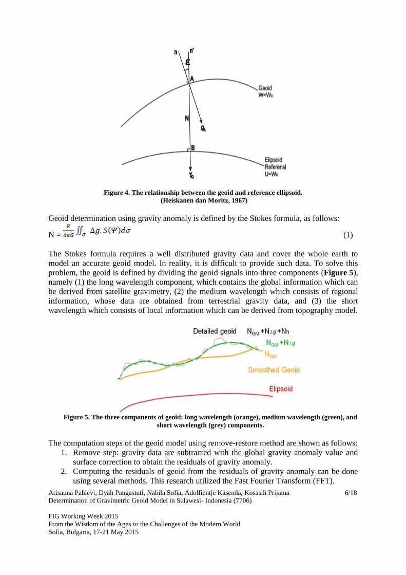
geoid determination is shown in Figure 4. One arbitrary point A on the geoid is projected to
point B on the reference ellipsoid. The distance AB is the undulation or geoid height (N),
while the angle between the normal geoid (n) and normal ellipsoid (n’) line is called the
deflection of vertical (ε).
Arisauna Pahlevi, Dyah Pangastuti, Nabila Sofia, Adolfientje Kasenda, Kosasih Prijatna
Determination of Gravimetric Geoid Model in Sulawesi- Indonesia (7706)
FIG Working Week 2015
From the Wisdom of the Ages to the Challenges of the Modern World
Sofia, Bulgaria, 17-21 May 2015
6/18
Figure 4. The relationship between the geoid and reference ellipsoid.
(Heiskanen dan Moritz, 1967)
Geoid determination using gravity anomaly is defined by the Stokes formula, as follows:
N = (1)
The Stokes formula requires a well distributed gravity data and cover the whole earth to
model an accurate geoid model. In reality, it is difficult to provide such data. To solve this
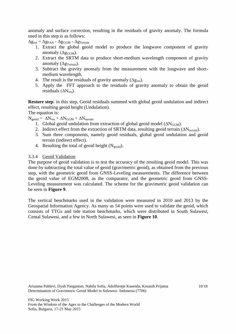
problem, the geoid is defined by dividing the geoid signals into three components (Figure 5),
namely (1) the long wavelength component, which contains the global information which can
be derived from satellite gravimetry, (2) the medium wavelength which consists of regional
information, whose data are obtained from terrestrial gravity data, and (3) the short
wavelength which consists of local information which can be derived from topography model.
Figure 5. The three components of geoid: long wavelength (orange), medium wavelength (green), and
short wavelength (grey) components.
The computation steps of the geoid model using remove-restore method are shown as follows:
1. Remove step: gravity data are subtracted with the global gravity anomaly value and
surface correction to obtain the residuals of gravity anomaly.
2. Computing the residuals of geoid from the residuals of gravity anomaly can be done
using several methods. This research utilized the Fast Fourier Transform (FFT).
ε

Arisauna Pahlevi, Dyah Pangastuti, Nabila Sofia, Adolfientje Kasenda, Kosasih Prijatna
Determination of Gravimetric Geoid Model in Sulawesi- Indonesia (7706)
FIG Working Week 2015
From the Wisdom of the Ages to the Challenges of the Modern World
Sofia, Bulgaria, 17-21 May 2015
7/18
3. Restore step: the residuals of geoid as obtained from step (2) are added with the global
geoid model value and indirect effects to obtain the geoid undulation value.
The remove-restore steps are shown in equations (2) and (3):
Ngeoid = ∆Nres + ∆NGM + ∆Nh (2)
∆gres = ∆gFA - ∆gGM - ∆gh (3)
3.2 Geometric Geoid
To determine the geometric geoid, the geoid undulation (N) is obtained from the height
difference between ellipsoid or geometric height (h) and orthometric height (H). The
geometric geoid undulation can be calculated if both geometric and orthometric height at a
certain point are known. The geometric geoid undulation can be computed using two
methods, namely the absolute and relative methods. The absolute method is done by
determining the undulation at one point using equation (6). While the relative method is done
by calculating the difference of the undulations at two points (ΔN) as shown in equations (7)
and (8) (Basciftci et al., 2006), and illustrated in Figure 6.
N = h –H (6)
NQ = NP + (hQ – hP) – (HQ – HP) (7)
This can be reduced to:
ΔNPQ = ΔhPQ - ΔHPQ (8)
Figure 6. Geometric undulation using absolute and relative methods (modified from Basciftci et al., 2006)
In this research, the geometric geoid is used as the validator of gravimetric geoid.
3.3 Data Computation Methodology
3.3.1 Case Study
The case study of this research is Sulawesi Island which is located at -6.5° S until 4.5°U and
118° until 126° E. This area was chosen because the short-medium wavelength data as
obtained from airborne gravity survey and the TTG are more evenly distributed that the other
two islands (see Figure 2). The case study area can be seen in Figure 7.

Arisauna Pahlevi, Dyah Pangastuti, Nabila Sofia, Adolfientje Kasenda, Kosasih Prijatna
Determination of Gravimetric Geoid Model in Sulawesi- Indonesia (7706)
FIG Working Week 2015
From the Wisdom of the Ages to the Challenges of the Modern World
Sofia, Bulgaria, 17-21 May 2015
8/18
Figure 7. Case study, Sulawesi Island
3.3.2 Data and Tools
The data used in this research are Global Geopotential Model (GGM), i.e. EGM2008, which
is combined with GOCE data as the long wavelength component, and the free air anomaly
from the airborne gravimetric in Sulawesi Island as the short-medium wavelength component.
The terrain data are corrected using SRTM30, which can be downloaded from
http://topex.ucsd.edu/WWW_html/srtm30_plus.html/. SRTM is used as the short wavelength
component. Those data are then processed in Gravsoft Package Software (Tscherning, 2014;
Srinivas et al., 2012).
3.3.3 Geoid Modelling
The determination of gravimetric geoid model is done using the remove-restore. This consists
of two computing steps, namely: processing the gravity data and geoid modelling. The first
step is the processing of raw data from the airborne gravity survey (gravity and position data)
to obtain the free air anomaly. The geoid modelling is computed from the free air anomaly
combined with other data, i.e. the Global Geopotential Model and SRTM. This research only
consists of the geoid modelling. The research scheme can be seen in Figure 8.

Arisauna Pahlevi, Dyah Pangastuti, Nabila Sofia, Adolfientje Kasenda, Kosasih Prijatna
Determination of Gravimetric Geoid Model in Sulawesi- Indonesia (7706)
FIG Working Week 2015
From the Wisdom of the Ages to the Challenges of the Modern World
Sofia, Bulgaria, 17-21 May 2015
9/18
Processing Geoid ModelR
esu
ltP
roce
ssin
gD
ata SRTM
Global
Geopotential
Model (EGM2008-
GOCE)
Free Air
Anomaly from
Airborne
Gravity Survey
Calculation of
Gravity Anomaly
and Geoid Model
For Long wave
length Component
Gravity
Anomaly
(GA)
longwave
Component
Geoid
Model
Longwave
Component
reduction of Free
Air Anomaly and
GA Longwave
Component
Calculation of GA
Terrain (Short
Wave Length)
GA include
terrain
Gravity
Anomaly
residual
non TC
Reduction GA of
GA Residual non
TC and GA
Include Terrain
GA residual
final (.lst)
Calculate N
residual
GeoGRID
N Residual
Combination of
N = Nlong+Nterrain+Nres
N total
Gridding GA
residual (dari .lst
ke .gri)
GA residual
final (.gri)
Figure 8. Processing cheme of the geoid modelling
Based on the scheme in Figure 8, the data processing step utilized remove-restore method.
Remove step: in this step, the gravity measurement data are subtracted with the global gravity
Remove Process
Restore Process
Arisauna Pahlevi, Dyah Pangastuti, Nabila Sofia, Adolfientje Kasenda, Kosasih Prijatna
Determination of Gravimetric Geoid Model in Sulawesi- Indonesia (7706)
FIG Working Week 2015
From the Wisdom of the Ages to the Challenges of the Modern World
Sofia, Bulgaria, 17-21 May 2015
10/18
anomaly and surface correction, resulting in the residuals of gravity anomaly. The formula
used in this step is as follows:
∆gres = ∆gFAA - ∆gGGM - ∆gTerrain
1. Extract the global geoid model to produce the longwave component of gravity
anomaly (∆gGGM).
2. Extract the SRTM data to produce short-medium wavelength component of gravity
anomaly (∆gTerrain).
3. Subtract the gravity anomaly from the measurement with the longwave and short-
medium wavelength.
4. The result is the residuals of gravity anomaly (∆gres).
5. Apply the FFT approach to the residuals of gravity anomaly to obtain the geoid
residuals (∆Nres).
Restore step: in this step, Geoid residuals summed with global geoid undulation and indirect
effect, resulting geoid height (Undulation).
The equation is:
Ngeoid = ∆Nres + ∆NGGM + ∆Nterrain
1. Global geoid undulation from extraction of global geoid model (∆NGGM).
2. Indirect effect from the extraction of SRTM data, resulting geoid terrain (∆Nterrain).
3. Sum three components, namely geoid residuals, global geoid undulation and geoid
terrain (indirect effect).
4. Resulting the total of geoid height (Ngeoid).
3.3.4 Geoid Validation
The purpose of geoid validation is to test the accuracy of the resulting geoid model. This was
done by subtracting the total value of geoid (gravimetric geoid), as obtained from the previous
step, with the geometric geoid from GNSS-Leveling measurements. The difference between
the geoid value of EGM2008, as the comparator, and the geometric geoid from GNSS-
Leveling measurement was calculated. The scheme for the gravimetric geoid validation can
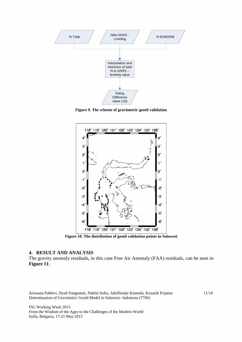
be seen in Figure 9.
The vertical benchmarks used in the validation were measured in 2010 and 2013 by the
Geospatial Information Agency. As many as 54 points were used to validate the geoid, which
consists of TTGs and tide station benchmarks, which were distributed in South Sulawesi,
Cental Sulawesi, and a few in North Sulawesi, as seen in Figure 10.
Arisauna Pahlevi, Dyah Pangastuti, Nabila Sofia, Adolfientje Kasenda, Kosasih Prijatna
Determination of Gravimetric Geoid Model in Sulawesi- Indonesia (7706)
FIG Working Week 2015
From the Wisdom of the Ages to the Challenges of the Modern World
Sofia, Bulgaria, 17-21 May 2015
11/18
Nilai GNSS -
Leveling
Interpolation and
reduction of total
N to GNSS –
leveling value
Fitting
Difference
value (.lst)
N Total N EGM2008
Figure 9. The scheme of gravimetric geoid validation
Figure 10. The distribution of geoid validation points in Sulawesi
4. RESULT AND ANALYSIS
The gravity anomaly residuals, in this case Free Air Anomaly (FAA) residuals, can be seen in
Figure 11.

Arisauna Pahlevi, Dyah Pangastuti, Nabila Sofia, Adolfientje Kasenda, Kosasih Prijatna
Determination of Gravimetric Geoid Model in Sulawesi- Indonesia (7706)
FIG Working Week 2015
From the Wisdom of the Ages to the Challenges of the Modern World
Sofia, Bulgaria, 17-21 May 2015
12/18
Figure 11. FAA Residuals
Figure 11 shows the FAA deficiency against the global model EGM08 by -60 mgal to 60
mgal. This means that the FAA signals in that range cannot be detected if using only the
global model. Therefore, the global model is not capable to detect the small variations in the
geoid as seen in Figure 12, where the geoid deficiency against the global model EGM08 by -
1 meter to 1 meter in Sulawesi.

Arisauna Pahlevi, Dyah Pangastuti, Nabila Sofia, Adolfientje Kasenda, Kosasih Prijatna
Determination of Gravimetric Geoid Model in Sulawesi- Indonesia (7706)
FIG Working Week 2015
From the Wisdom of the Ages to the Challenges of the Modern World
Sofia, Bulgaria, 17-21 May 2015
13/18
Figure 12. The geoid residuals in Sulawesi
Figure 13. Gravimetric geoid model of Sulawesi
Figure 13 shows the gravimetric geoid model of Sulawesi. The pattern of geoid in Sulawesi is

Arisauna Pahlevi, Dyah Pangastuti, Nabila Sofia, Adolfientje Kasenda, Kosasih Prijatna
Determination of Gravimetric Geoid Model in Sulawesi- Indonesia (7706)
FIG Working Week 2015
From the Wisdom of the Ages to the Challenges of the Modern World
Sofia, Bulgaria, 17-21 May 2015
14/18
that the value of the geoid increases from sothwest to northeast, with the geoid height range
between 45-80 meter.
To test the accuracy of the resulting geoid model, the geoid validation was done by comparing
the difference between geometric geoid and gravimetric geoid against the airborne gravity
measurements and EGM08. The validation result can be seen in Table 1.
Table 1. Comparison of the difference of geometric N and gravimetric N between the airborne gravity
result and EGM08
Table 1 shows that the geoid model from airborne gravity measurement has better quality

Arisauna Pahlevi, Dyah Pangastuti, Nabila Sofia, Adolfientje Kasenda, Kosasih Prijatna
Determination of Gravimetric Geoid Model in Sulawesi- Indonesia (7706)
FIG Working Week 2015
From the Wisdom of the Ages to the Challenges of the Modern World
Sofia, Bulgaria, 17-21 May 2015
15/18
than the EGM08 model. This can be seen from the value of standard deviation of both
models. The value of geoid standard deviation from airborne gravity result is smaller than that
from EGM08. The accuracy of the geoid model from airborne gravity measurement is 69 cm,
while the EGM08 geoid model has the accuracy of 94 cm.
The individual accuracy of the geoid from the measurement in Sulawesi dan be seen in Table
2. Table 2. Comparison of airborne gravity N and EGM08 N partially
Statistic N Airborne-N
Geometric N EGM08-N Geometric
South Sulawesi South Sulawesi
Average 0.66606367 0.865454579
Stdev 0.16821467 0.279395187
RMS 0.686352336 0.908134238
Central Sulawesi Central Sulawesi
Average 0.49514 0.764666667
Stdev 0.166689312 0.524247735
RMS 0.520669369 0.917185052
North Sulawesi North Sulawesi
Average 1.011360835 1.020377502
Stdev 0.351501671 0.634774851
RMS 1.061042849 1.173436338
The geoid model from airborne gravity measurement in Central Sulawesi has better accuracy
than North and South Sulawesi. This can be seen from the the variation of the difference
between geometric geoid and gravimetric geoid. The difference is smaller for Central
Sulawesi than North and South Sulawesi, with the RMS value of 52 cm. The gravimetric
geoid from airborne gravity measurement can improve the accuracy of global geoid model
EGM 2008 by 22 cm in South Sulawesi, 39 cm in Central Sulawesi, and 11 cm in North
Sulawesi. While for the island as a whole, the gravimetric geoid from airborne gravity
measurement can improve the accuracy of EGM 2008 by 25 cm.

Arisauna Pahlevi, Dyah Pangastuti, Nabila Sofia, Adolfientje Kasenda, Kosasih Prijatna
Determination of Gravimetric Geoid Model in Sulawesi- Indonesia (7706)
FIG Working Week 2015
From the Wisdom of the Ages to the Challenges of the Modern World
Sofia, Bulgaria, 17-21 May 2015
16/18
Figure 14. The difference between geometric N and gravimetric N in South Sulawesi
Figure 15. The difference between geometric N and gravimetric N in Central Sulawesi
Figure 16. The difference between geometric N and gravimetric N in North Sulawesi
Based on Figures 14, 15, and 16, the geoid model from airborne gravity measurement has
better consistency, as can be seen from the undulation difference. The variation in undulation
difference between gravimetric geoid from airborne gravity measurement and geometric
geoid in South Sulawesi is around 0.397 until 1.317 meter, while the difference between the
EGM2008 geoid model and geometric geoid is around 0.435 until 1.454 meter. The result is
better in Central Sulawesi, where the undulation difference between gravimetric geoid from
airborne gravity measurement and geometric geoid is around 0.141 until 0.744 meter, while
the difference between EGM2008 geoid model with geometric geoid is around 0.186 and
1.784 meter. In North Sulawesi, the undulation difference between gravimetric geoid from
airborne gravity measurement and geometric geoid is around 0.677 until 1.573 meter, while
the difference between EGM2008 geoid model and geometric geoid is around 0.231 until
1.580 meter.
5. CONCLUSIONS

Arisauna Pahlevi, Dyah Pangastuti, Nabila Sofia, Adolfientje Kasenda, Kosasih Prijatna
Determination of Gravimetric Geoid Model in Sulawesi- Indonesia (7706)
FIG Working Week 2015
From the Wisdom of the Ages to the Challenges of the Modern World
Sofia, Bulgaria, 17-21 May 2015
17/18
This reseach aims at developing the gravimetric geoid model of Sulawesi Island based on
airborne gravity survey. The remove-restore model was used to determine the gravimetric
geoid model. The standard deviation of the resulting model from airborne gravity data is
better than the global geoid model (EGM2008). Therefore, the utilization of airborne gravity
for the determination of gravimetric geoid model in Indonesia is very beneficial, because this
survey allows a faster determination of Indonesian geoid model with a high accuracy,
improving the precision of global geoid model, namely the EGM2008, by 25 cm in Sulawesi
Island.
REFERENCES
Badan Informasi Geospasial. 2012. Summary Report, The Indonesian Airborne Gravity a
Joint Survey BIG-DTU Space 2008-2011. BIG: Cibinong-Bogor.
Badan Informasi Geospasoal. 2013. Peraturan Kepala Badan Informasi Geospasial Nomor 15
Tahun 2013 Tentang Sistem Referensi Geospasial Indonesia 2013. BIG: Cibinong-
Bogor.
Brown, G.S., 1977. The average impulse response of a rough surface and its application.
IEEE Transactions on Antennas and Propagation. 25 (1), pp. 67–74.
Heiskanen, W. A. & H. Moritz, 1967. Physical Geodesy, Freeman, San Francisco.
Hwang, C. 1997. Analysis of some systematic errors affecting altimeter derived sea surface
gradient with application to geoid determination over Taiwan. Journal of Geodesy,
71, pp. 113-130.
Hwang, C., 1998, Inverse Vening Meinesz formula and deflection-geoid formula: applications
to the predictions of gravity and geoid over the South China Sea. Journal of Geodesy,
72, pp. 304-312.
Hwang, C., Guo, J., Deng, X.L., 2006. Coastal gravity anomalies from retracked Geosat/GM
altimetry: improvement, limitation and the role of airbornegravity data. Journal of
Geodesy, 80,pp. 204–216.
Pangastuti, D dan Pahlevi, A. 2013. Training Report-processing geoid model in Danmarks
Technisce Universitet (DTU). Denmark. BIG: Bogor.
Pangastuti, D. 2012. Penentuan Model Geoid Bali Menggunakan Metode Least Square
Collocation. FIT ISI: Jakarta.
Prijatna, K. 2010. Pengembangan Model Pengkombinasian Data Gayaberat dengan Model
Geopotensial Global untuk Penentuan Geoid RegionalWilayah Indonesia. Desertasi
Program Doktor. Institut Teknologi Bandung
Sanso, F dan Sideris, M. 2013. Geoid Determination-Theory and Methode. Springer: London.
Tscherning, C.C. 2014. Geoid determination by least-squares collocation using GRAVSOFT.
Copenhagen: University of Copenhagen.
Wahr. J. 1996. Geodesy and Gravity. Samizdat: Corolado.
Yildiz, H., Forsberg, R., Ågren, J., Tscherning, C.C. & Sjöberg, L.E. 2011. "Comparison of
removecompute- restore and least squares modification of Stokes' formula techniques
to quasi-geoid determination over the Auvergne test area". Journal of Geodetic
Science. 2, 1-12.
CONTACTS
Arisauna Maulidyan Pahlevi, ST.

Arisauna Pahlevi, Dyah Pangastuti, Nabila Sofia, Adolfientje Kasenda, Kosasih Prijatna
Determination of Gravimetric Geoid Model in Sulawesi- Indonesia (7706)
FIG Working Week 2015
From the Wisdom of the Ages to the Challenges of the Modern World
Sofia, Bulgaria, 17-21 May 2015
18/18
Geospatial Information Agency
Jalan Raya Jakarta-Bogor KM. 46, Cibinong
Bogor
INDONESIA
Tel. +62-21-8756081
Fax + 62-21-8758061
Email: [email protected]
Dyah Pangastuti, ST.
Geospatial Information Agency
Jalan Raya Jakarta-Bogor KM. 46, Cibinong
Bogor
INDONESIA
Tel. +62-21-8756081
Fax + 62-21-8758061
Email: [email protected]
Nabila Sofia, ST. MT.
Institut Teknologi Bandung
Jalan Ganesha Nomor 10
Bandung
INDONESIA
Tel. +62-22-2530701
Fax + 62-22-2530702
Email: [email protected]
Dr. Adolfientje Kasenda
Geospatial Information Agency
Jalan Raya Jakarta-Bogor KM. 46, Cibinong
Bogor
INDONESIA
Tel. +62-21-8756081
Fax + 62-21-8758061
Email: [email protected] / [email protected]
Dr. Kosasih Prijatna
Institut Teknologi Bandung
Jalan Ganesha Nomor 10
Bandung
INDONESIA
Tel. +62-22-2530701
Fax + 62-22-2530702
Email: [email protected]